Midday Stem Water Potential. Rolston St. Hilaire Plant and Environmental Sciences
|
|
|
- Zoe Logan
- 5 years ago
- Views:
Transcription
1 Midday Stem Water Potential Rolston St. Hilaire Plant and Environmental Sciences

2 Ways to improve irrigation Irrigation scheduling When to irrigate How much to apply efficiency in pecans Irrigation scheduling depends on the sensitivity of field measurements to water deficit. h6p://


 ncare.")

3 Measurements used for detecting water status in pecan orchards Plant-based Soil-based Plant-soil-based monash.edu.au Midday stem water Soil TDR Lysimeters potential (Ψ smd ) ncare.gov.jo Limitations: Small area, extraordinary cost, extraction time, leaf destruction.


4 We tried remote sensing to detect moisture status NASA'sLandsat- 8satellite Handheld portable Spectroradiometer Aerial photo plane Portable Spectroradiometer

.")
5 Remote sensing applications Scale up leaf-level physiological responses to large areas Detect pigment concentration Spectral regions from nm and nm were correlated with pecan water deficit (Johnson 2004). Landsat-5 image Electromagnetic spectrum

6 Objectives The overall goal of this research was to develop an advanced sensing and management technologies tooptimize water resources and drought monitoring of pecan orchards. Initial research objectives: 1 Screen leaf-level physiological changes that occur during cyclic irrigation to determine parameters that best represented changes in moisture status. 2 Assess the impact of water deficit developed during the flood irrigation dry-down cycles on photosynthesis and gas exchange. 3 Establish preliminary values of midday stem water potential where photosynthesis and gas exchange of pecans are affected.

7 Locations of the studies

8 Locations of the studies Mesilla Valley La Mancha Leyendecker


9 Sampling design

10 Sampling design
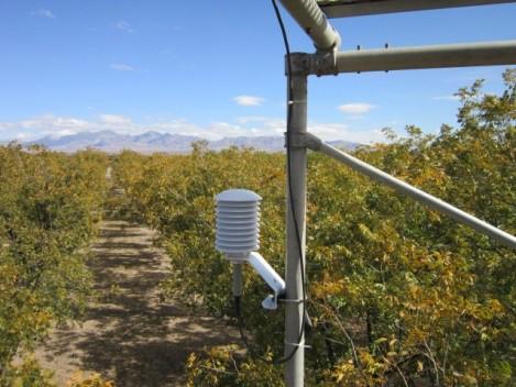


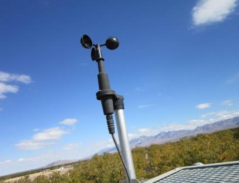

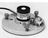
11 Meteorological instrumentation Net radiometer Temperature & relative humidity Anemometer Pyranometer


12 Treatment T1 Well-watered treatment T2 Moderate treatment T3 Severe treatment Irrigation Irrigation cycle Irrigation


")
 Remotely")
13 Spectral and physiological measurements Irrigation Day 1 Day 3 Day Measurements a) Midday stem water potential b) Remotely sensed surface reflectance data Irrigation

14 Satellite image processing 1) Satellite images were downloaded from United States Geological SurveyGlobal Visualization Viewer
 Radiometric correction")


15 Satellite image processing 2) Radiometric correction Improve the accuracy of surface spectralreflectance 3) Geometric correction Place data in their proper position.
 (--0.002 x ρ B ) + (0.002 x ρ G ) (0.")
16 Vegetation indices Band ratio B5/B7 Normalized Difference Infrared Index (NDII) (ρ NIR ρ SWIR(5) ) /(ρ NIR +ρ SWIR(5) ) Vegetation moisture index I I (VMI--II) ( x ρ B ) + (0.002 x ρ G ) (0.001 x ρ SWIR(2) ) (ρ NIR ρ R ) / (ρ NIR + ρ R ) NDVI


")

17 Physiological measurements Midday stem water potential Leaf area ratio Relative water content (%) Leaf temperature, transpiration Chlorophyll fluorescence (F v /F m ) Chlorophyll content (SPAD) Photosynthesis, stomatal conductance, vapor pressure deficit.
18 Screen leaf-level physiological variables Midday stem water potential Relative water content Leaf temperature Leaf area ratio Transpiration Photosynthesis Stomatal conductance Vapor pressure deficit Chlorophyll fluorescence Chlorophyll content (SPAD) Midday stem water potential (Ψ smd )
19 Remote sensing data Boxplot analysis of vegetation moisture index at three levels of midday stem water potential (Ψ smd ) at the La Mancha pecan orchard measured in 2012 and 2013.
20 Remote sensing index Boxplot analysis of vegetation moisture index at three levels of midday stem water potential (Ψ smd ) at the Leyendecker pecan orchard measured in 2012 and 2013.

21 Screen leaf-level physiological variables Midday stem water potential (Ψ smd ),and relative water content (RWC) of La Mancha and Leyendecker orchards measured in Different letters indicated a significant difference between irrigation treatments (P < 0.05).
22 Midday stem water potential boxplots of La Mancha and Leyendecker pecan orchards (Mesilla Valley, New Mexico) measured in 2012 and Rectangles represent the 25%, 50% (median), and 75% percentile of the data Outlier Midday stem water potential (MPa) Mean (dotted line) Maximum non-outlier value 75th percentile Median 25th percentile Minimum non-outlier value -1.6 Well watered (n = 60) Water deficit (n = 50) La Mancha (sandy loam soil) Leyendecker (clay loam soil)
23 Screen leaf-level physiological variables Boxplots of midday stem water potential (Ψ smd ) of two southern New Mexico pecan orchards subjected to cyclic flood irrigation (La Mancha and Leyendecker) during the 2011 growing season.
24 Relationship between stomatal conductance and midday stem water potential of trees at La Mancha and Leyendecker, southern New Mexico pecan orchards.
25 Relationship between photosynthesis and midday stem water potential of trees at La Mancha and Leyendecker, southern New Mexico pecan orchards. We used data set within the range -0.9 to -2.0 MPa to derive the mixed model equation.
26 Relationship between photosynthesis (decline) and midday stem water potential of trees at La Mancha and Leyendecker, southern New Mexico pecan orchards A B Photosynthesis % Decline % Decline Photosynthesis [CO 2 ( µ mol. m s )] P< Water deficit Well watered Water deficit Well watered Midday s tem water potential (MP a) Midday s tem water potential (MP a) L a Mancha L eyendecker P<
27 Conclusions Midday stem water potential was the best performing leaf-level physiological response variable for detecting moisture status in pecans. A marked decline in photosynthesis was noticed when midday stem water potential dropped below -0.9 MPa. A 50% reduction in photosynthesis and gas exchange only occurred when midday stem water potential exceeded -1.5 MPa. Data from a handheld spectroradiometer could be used to differentiate between well watered (Ψ smd -0.4 to MPa) and moderate water deficit (Ψ smd -0.9 to -1.5 MPa) trees.
28 Recommendation Maintain pecan orchards at midday stem water potentials that range between to MPa to prevent significant reductions in carbon assimilation and gas exchange.

29 Acknowledgements Personnel Yahia Othman Caiti Steele Dawn Vanleeuwen Richard Heerema Salim Bawazir Max P. Bleiweiss Cameron Radosevich Sanjit Kumar Deb Mohammad Sawaleha Brandon Radosevich Joshua Sherman Mid Ray Clark Leyendecker Research Staff Funding USDA-SCRI, grant no Plant and Environmental Sciences Department
Hyperspectral Surface Reflectance Data Detect Low Moisture Status of Pecan Orchards during Flood Irrigation
 J. AMER. SOC. HORT. SCI. 140(5):449 458. 2015. Hyperspectral Surface Reflectance Data Detect Low Moisture Status of Pecan Orchards during Flood Irrigation Yahia Othman 1 Plant and Environmental Sciences,
Response to salinity in young olive trees of three Iberian varieties Coelho R 1,2, Sousa A 1, Rato A 1, Vaz M 1
 Response to salinity in young olive trees of three Iberian varieties Coelho R 1,2, Sousa A 1, Rato A 1, Vaz M 1 1 ICAAM, Universidade de Évora, Apartado 94, 7002-554 Évora, Portugal 2 rcoelho@uevora.pt
Natural rubber production and productivity have to be increased to meet the growing demands of rubber based industries
 3-1-212 IRC 212, KERALA, INDIA 2 Natural rubber production and productivity have to be increased to meet the growing demands of rubber based industries High yielding clones with increased tolerance to
A Simple Irrigation Scheduling Approach for Pecan Irrigation in the Lower Rio Grande Valley
 ABSTRACT A Simple Irrigation Scheduling Approach for Pecan Irrigation in the Lower Rio Grande Valley Zhorab Samani, Salim Bawazir, Max Bleiweiss, Rhonda Skaggs, John Longworth, Aldo Piñon,Vien Tran Submitted
HORTSCIENCE 47(7):
:") HORTSCIENCE 47(7):907 916. 2012. Estimating Midday Leaf and Stem Water Potentials of Mature Pecan Trees from Soil Water Content and Climatic Parameters Sanjit K. Deb 1, Manoj K. Shukla, and John G. Mexal
HORTSCIENCE 47(7):907 916. 2012. Estimating Midday Leaf and Stem Water Potentials of Mature Pecan Trees from Soil Water Content and Climatic Parameters Sanjit K. Deb 1, Manoj K. Shukla, and John G. Mexal
Remote Estimation of Leaf and Canopy Water Content in Winter Wheat with Different Vertical Distribution of Water-Related Properties
 Remote Sens. 2015, 7, 4626-4650; doi:10.3390/rs70404626 Article OPEN ACCESS remote sensing ISSN 2072-4292 www.mdpi.com/journal/remotesensing Remote Estimation of Leaf and Canopy Water Content in Winter
CROP STATE MONITORING USING SATELLITE REMOTE SENSING IN ROMANIA
 CROP STATE MONITORING USING SATELLITE REMOTE SENSING IN ROMANIA Dr. Gheorghe Stancalie National Meteorological Administration Bucharest, Romania Content Introduction Earth Observation (EO) data Drought
Figure 1. Location of research sites in the Ameriflux network (from Ameriflux web site,
 CONTEXT - AMERIFLUX NETWORK Figure 1. Location of research sites in the Ameriflux network (from Ameriflux web site, http://public.ornl.gov/ameriflux/). AMERIFLUX OBJECTIVES: Quantify spatial and temporal
The Science Behind Measuring Depletions
 The Science Behind Measuring Depletions 1 The Science Behind Measuring Depletions Salim Bawazir, New Mexico State University Salim Bawazir is Associate Professor in the Civil Engineering (CE) Department
PROGRESS WITH MEASURING AND UTILIZING CROP EVAPOTRANSPIRATION (ETc) IN WALNUT
 IN WALNUT") PROGRESS WITH MEASURING AND UTILIZING CROP EVAPOTRANSPIRATION (ETc) IN WALNUT Allan Fulton, Cayle Little, Richard Snyder, Richard Buchner, Bruce Lampinen, and Sam Metcalf ABSTRACT Since 1982 when the California
PROGRESS WITH MEASURING AND UTILIZING CROP EVAPOTRANSPIRATION (ETc) IN WALNUT Allan Fulton, Cayle Little, Richard Snyder, Richard Buchner, Bruce Lampinen, and Sam Metcalf ABSTRACT Since 1982 when the California
Application of Remote Sensing On the Environment, Agriculture and Other Uses in Nepal
 Application of Remote Sensing On the Environment, Agriculture and Other Uses in Nepal Dr. Tilak B Shrestha PhD Geography/Remote Sensing (NAPA Member) A Talk Session Organized by NAPA Student Coordination
Department of Environmental Sciences, Nanjing Institute of Meteorology, Nanjing , China
 Evaluation of Remote Sensing Approaches to Monitor Crop Conditions under Specific Input Levels and Cropping Diversity X. Guo 1, Y. Zheng 1,4, O. Olfert 2, S. Brandt 3, A.G. Thomas 2, R.M. Weiss 2, L. Sproule
Recent increased frequency of drought events in Poyang Lake Basin, China: climate change or anthropogenic effects?
 Hydro-climatology: Variability and Change (Proceedings of symposium J-H02 held during IUGG2011 in Melbourne, Australia, July 2011) (IAHS Publ. 344, 2011). 99 Recent increased frequency of drought events
MULTI-SOURCE SPECTRAL APPROACH FOR EARLY WATER-STRESS DETECTION IN ACTUAL FIELD IRRIGATED CROPS
 Department of Geography and Environmental Studies MULTI-SOURCE SPECTRAL APPROACH FOR EARLY WATER-STRESS DETECTION IN ACTUAL FIELD IRRIGATED CROPS Maria Polinova 1, Thomas Jarmer 2, Anna Brook 1 1 Spectroscopy
Research Update Stem Water Potential Baseline and Mechanical Hedging of Oil Olive. Bill Krueger UCCE Farm Advisor, Glenn and Tehama Countiesw
 Research Update Stem Water Potential Baseline and Mechanical Hedging of Oil Olive Bill Krueger UCCE Farm Advisor, Glenn and Tehama Countiesw How is Tree Stress (Stem Water Potential) Measured, Conceptually?
Using Aerial Imagery for Irrigation Management Jake LaRue Valmont Irrigation, Valley, NE
 Using Aerial Imagery for Irrigation Management Jake LaRue Valmont Irrigation, Valley, NE jlarue@valmont.com Abstract Water, energy and labor resources are often limited and the need for improvements in
Hydrological Applications of LST Derived from AVHRR
 Hydrological Applications of LST Derived from AVHRR By Balaji Narasimhan Research Assistant Department of Agricultural Engineering Texas A&M University Outline Introduction All about LST Model Development
EVALUATING WATER REQUIREMENTS OF DEVELOPING WALNUT ORCHARDS IN THE SACRAMENTO VALLEY
 EVALUATING WATER REQUIREMENTS OF DEVELOPING WALNUT ORCHARDS IN THE SACRAMENTO VALLEY Allan Fulton ABSTRACT Most of the research on irrigation of walnuts has primarily focused on plant water relations and
VEGETATION AND SOIL MOISTURE ASSESSMENTS BASED ON MODIS DATA TO SUPPORT REGIONAL DROUGHT MONITORING
 University of Szeged Faculty of Science and Informatics Department of Physical Geography and Geoinformatics http://www.geo.u-szeged.hu kovacsf@geo.u-szeged.hu Satellite products for drought monitoring
Methods of Irrigation Scheduling and Determination of Irrigation threshold triggers
 Methods of Irrigation Scheduling and Determination of Irrigation threshold triggers Introduction Principle of irrigation Scheduling Methods of irrigation scheduling Determination of Irrigation Triggers
Spectral Responses of Eucalyptus Trees Submitted to Natural Hydrocarbon Seepages: An Integrated Approach from Leaf- to Canopy- Scales
 State University of Campinas - UNICAMP Institute of Geosciences (IG) Spectral Responses of Eucalyptus Trees Submitted to Natural Hydrocarbon Seepages: An Integrated Approach from Leaf- to Canopy- Scales
Evaluation of Indices for an Agricultural Drought Monitoring System in Arid and Semi-Arid Regions
 Evaluation of Indices for an Agricultural Drought Monitoring System in Arid and Semi-Arid Regions Alireza Shahabfar, Josef Eitzinger Institute of Meteorology, University of Natural Resources and Life Sciences
REMOTE SENSING ON GANODERMA DISEASE
 REMOTE SENSING ON GANODERMA DISEASE Nisfariza Mohd Noor Maris Senior Lecturer Department of Geography, University of Malaya KUALA LUMPUR, MALAYSIA Outline Introduc.on Ganoderma BSR Pathological symptom
SPECTRAL RESPONSE OF WATER STRESS IN QUERCUS SPP.
 SPECTRAL RESPONSE OF WATER STRESS IN QUERCUS SPP. IMPLICATIONS TOWARD EARLY DETECTION OF OAK WILT DISEASE Blake Weissling, Hongjie Xie, and Paul Jurena Laboratory of Remote Sensing and Geoinformatics Earth
The precision orchard?
 The precision orchard? Techniques from precision agriculture and their potential application to seed orchard production & management Chuck Bulmer BC FLNRORD, Vernon Presented to: BC Seed Orchard Association,
Measuring canopy nitrogen nutrition in tobacco plants using hyper spectrum parameters
 Measuring canopy nitrogen nutrition in tobacco plants using hyper spectrum parameters Yong Zou, Xiaoqing YE, et al. Shenzhen Tobacco Ind. Co., Ltd. of CNTC Layout Background Experimental Program Experimental
Integrated Early-Warning Monitoring and Forecasting: Data Products
 Integrated Early-Warning Monitoring and Forecasting: Data Products John J. Qu, Xianjun Hao & Lingli Wang jqu@gmu.edu Environmental Science & Technology Center (ESTC) College of Science George Mason University
DEMOCRATIC SOCIALIST REPUBLIC OF SRI LANKA
 SRI LANKA 1 DEMOCRATIC SOCIALIST REPUBLIC OF SRI LANKA Area 65610km2 Water 4.4% Population 20,277,597 Highest biodiversity density in Asia 2 3 Arthur C Clarke Institute for Modern Technologies (ACCIMT)
Improving Evapotranspiration Estimation Using Remote Sensing Technology
 Improving Evapotranspiration Estimation Using Remote Sensing Technology By Zohrab A. Samani, Professor A. Salim Bawazir, Associate Professor Civil Engineering Department New Mexico State University TECHNICAL
To provide timely, accurate, and useful statistics in service to U.S. agriculture
 NASS MISSION: To provide timely, accurate, and useful statistics in service to U.S. agriculture What does NASS do? Administer USDA s Statistical Estimating Program Conduct the 5-year Census of Agriculture
Chapter 4. Methodology and Modeling for Carbon Sequestration Pattern in Cashew Plantation
 Chapter 4 Methodology and Modeling for Carbon Sequestration Pattern in Cashew Plantation In this chapter, a new approach for carbon sequestration pattern of broad leaf vegetation is proposed using modified
Farming from Space: Current and future opportunities for remote sensing to boost productivity for grain growers
 Farming from Space: Current and future opportunities for remote sensing to boost productivity for grain growers Hamlyn G Jones Division of Plant Sciences and University of Dundee, UK School of Plant Biology
POTENTIALS FOR DETECTING CANOPY WATER STRESS USING GEOSTATIONARY MSG-SEVIRI SWIR DATA
 POTENTIALS FOR DETECTING CANOPY WATER STRESS USING GEOSTATIONARY MSG-SEVIRI SWIR DATA Rasmus Fensholt, *Department of Geography and Geology, University of Copenhagen, Denmark Co-workers; Silvia Huber*,
COMPREHENSIVE PROJECT REPORT Wes Asai, Paul Verdegaal, Warren Micke, Beth Teviotdale
 COMPREHENSIVE PROJECT REPORT 1993-94 Project No. 93-H5 - Effects of Water Supply and Irrigation Strategies on Almonds Project Leader: Cooperating Personnel: Terry L. Prichard, Water Management Specialist
Use of Chlorophyll Meters to Assess Nitrogen Fertilization Requirements for Optimum Wheat Grain and Silage Yield and Quality
 Project Title: Use of Chlorophyll Meters to Assess Nitrogen Fertilization Requirements for Optimum Wheat and Silage and Quality Project Leader: Brian Marsh Farm Advisor, UCCE Kern County Abstract Nitrogen
Study of Water Quality using Satellite data
 2nd Workshop on Parameterization of Lakes in Numerical Weather Prediction and Climate Modelling Study of Water Quality using Satellite data M. Potes, M. J. Costa (Évora Geophysics Centre, PORTUGAL) This
Evaluation of Air-infused Water Applied to Creeping Bentgrass Turf Prairie Turfgrass Research Centre Mark A. Anderson and James B.
 Evaluation of Air-infused Water Applied to Creeping Bentgrass Turf Prairie Turfgrass Research Centre Mark A. Anderson and James B. Ross January 2011 Summary This trial was developed in order to assess
Remote Sensing of Land & Vegetation. C S Murthy
 Remote Sensing of Land & Vegetation C S Murthy Remote Sensing current status New era of RS in 21 st Century Increased utilisation of data Quantitative algorithms/improved retrieval methods Better calibrations
Utilizing normalized difference vegetation indices (NDVI) and in-season crop and soil variables to estimate corn grain yield.
 and in-season crop and soil variables to estimate corn grain yield.") Utilizing normalized difference vegetation indices (NDVI) and in-season crop and soil variables to estimate corn grain yield. T.M. Shaver, R. Khosla, and D.G. Westfall Department of Soil and Crop Sciences,
Utilizing normalized difference vegetation indices (NDVI) and in-season crop and soil variables to estimate corn grain yield. T.M. Shaver, R. Khosla, and D.G. Westfall Department of Soil and Crop Sciences,
ET and Deficit Irrigation Approaches in Cotton
 ET and Deficit Irrigation Approaches in Cotton Daniel Munk University of California Cooperative Extension Fresno dsmunk@ucdavis.edu Current Issues State water supply- increasing water for environmental,
Supplementary Material. A - Population density
 Gond, V. et al. Vegetation structure and greenness in Central Africa from MODIS multitemporal data. 2013. Phil Trans Roy Soc B 368 doi: 10.1098/rstb.2012.0309 Supplementary Material A - Population density
Remote Sensing Uses in Agriculture at NASS
 Remote Sensing Uses in Agriculture at NASS United States Department of Agriculture (USDA) National Agriculture Statistics Service (NASS) Research and Development Division Geospatial Information Branch
CONTROL OF WETLAND HYDROLOGY BY BIOTIC PROCESSES
 HANDOUT # 2 (For 10/6 and 10/8 2004) ESP 155 Wetland Ecology, Fall 2004 Hydrology WETLAND HYDROLOGY Basic terms & concepts - most important determinant for establishing and maintenance of specific types
Satellite image classification of vegetation and surface water for assessment of flood damage to agricultural crops
 Satellite image classification of vegetation and surface water for assessment of flood damage to agricultural crops Lisa Colson 2, Mark Lindeman 1, Dath Mita 1, Tatiana Nawrocki 2, Paulette Sandene 1,
Full terms and conditions of use:
 This article was downloaded by:[george Mason University] [George Mason University] On: 26 March 2007 Access Details: [subscription number 768492716] Publisher: Taylor & Francis Informa Ltd Registered in
Estimation of chlorophyll-a concentration in estuarine waters:
 Estimation of chlorophyll-a concentration in estuarine waters: case study of the Pearl River estuary Yuanzhi Zhang *, Chuqun Chen #, Hongsheng Zhang *, Xiaofei*, Chen Guiying Chen# *Institute of Space
Phenotyping transpiration efficiency: Linking trait dissection to genetics
 Phenotyping transpiration efficiency: Linking trait dissection to genetics Erik van Oosterom, Karine Chenu, Greg McLean, Geetika, Kurt Deifel, Richard Sulman, Emma Mace, David Jordan, Graeme Hammer Outline
Remote Sensing for Monitoring USA Crop Production: What is the State of the Technology
 Remote Sensing for Monitoring USA Crop Production: What is the State of the Technology Monitoring Food Security Threats from Space - A CELC Seminar Centurion, SA 21 April 2016 David M. Johnson Geographer
How are these equations relevant to remotely sensed data? Source: earthsci.org/rockmin/rockmin.html
 Lecture 3 How does light give us information about environmental features Revision Select a different scoop from last week Post the key points as a reaction to http://www.scoop.it/t/env22-52-w2 (need to
Remote sensing for crop water stress detection in greenhouses
 Remote sensing for crop water stress detection in greenhouses Bartzanas T. 1, Katsoulas N. 1,2, Elvanidi A. 1,2, Ferentinos K.P. 1, Kittas C. 1,2 1 Centre for Research and Technology Hellas, Institute
Use of Chlorophyll Meters to Assess Nitrogen Fertilization Requirements for Optimum Wheat Grain and Silage Yield and Quality
 Project Title: Use of Chlorophyll Meters to Assess Nitrogen Fertilization Requirements for Optimum Wheat Grain and Silage Yield and Quality Project Leader: Brian Marsh Farm Advisor, UCCE Kern County Abstract
Forest change detection in boreal regions using
 Forest change detection in boreal regions using MODIS data time series Peter Potapov, Matthew C. Hansen Geographic Information Science Center of Excellence, South Dakota State University Data from the
HYDROLOGY AND WATER RESOURCES REMOTE SENSING IN SOIL AND WATER RESOURCE MANAGEMENT
 Ninth International Water Technology Conference, IWTC9 2005, Sharm El-Sheikh, Egypt 689 HYDROLOGY AND WATER RESOURCES REMOTE SENSING IN SOIL AND WATER RESOURCE MANAGEMENT Behrooz Sari Sarraf*, S. Reza
WATER STRESS ASSESSMENT IN MAIZE CROP USING FIELD HYPERSPECTRAL DATA
 WATER STRESS ASSESSMENT IN MAIZE CROP USING FIELD HYPERSPECTRAL DATA V.S.Manivasagam 1 and R.Nagarajan 2 1 Centre of Studies in Resources Engineering, Indian Institute of Technology Bombay, Powai, Mumbai
AGRICULTURAL CROP MAPPING USING OPTICAL AND SAR MULTI- TEMPORAL SEASONAL DATA: A CASE STUDY IN LOMBARDY REGION, ITALY
 AGRICULTURAL CROP MAPPING USING OPTICAL AND SAR MULTI- TEMPORAL SEASONAL DATA: A CASE STUDY IN LOMBARDY REGION, ITALY G. Fontanelli, A. Crema, R. Azar, D. Stroppiana, P. Villa, M. Boschetti Institute for
30 Years of Tree Canopy Cover Change in Unincorporated and Incorporated Areas of Orange County,
 30 Years of Tree Canopy Cover Change in Unincorporated and Incorporated Areas of Orange County, 1986-2016 Final Report to Orange County July 2017 Authors Dr. Shawn Landry, USF Water Institute, University
INFLUENCE OF FOREST STAND PARAMETERS ON VEGETATION INDICES USED FOR CONIFEROUS FOREST DAMAGE ASSESSMENT
 INFLUENCE OF FOREST STAND PARAMETERS ON VEGETATION INDICES USED FOR CONIFEROUS FOREST DAMAGE ASSESSMENT Jonas Ard6 Department of Physical Geography University of Lund S61vegatan 13 S-223 62 Lund, SWEDEN
Fluorescent Ratio Chlorophyll Content Measurement Nondestructive measurement of very small leaves and difficult samples.
 Application Note: #0212 Fluorescent Ratio Chlorophyll Content Measurement Nondestructive measurement of very small leaves and difficult samples. Possible applications include conifer needles, immature
Forest Change Caused by Wind, Water, Ice, Fire, Insects/Disease & Harvesting
 Forest Change Caused by Wind, Water, Ice, Fire, Insects/Disease & Harvesting Why use remote sensing for mapping forest changes? Synoptic view of damage on a forest landscape or regional level. Can stop
Irrigation A key component of high quality. Farming Systems Research division Ian Goodwin, Senior research scientist
 Irrigation A key component of high quality Farming Systems Research division Ian Goodwin, Senior research scientist Weather Conditions (sunlight, wind, humidity and temperature) Orchard water balance CROP
Estimation of crop water stress in a nectarine orchard using high-resolution imagery from unmanned aerial vehicle (UAV)
") 21st International Congress on Modelling and Simulation, Gold Coast, Australia, 29 Nov to 4 Dec 215 www.mssanz.org.au/modsim215 Estimation of crop water stress in a nectarine orchard using high-resolution
21st International Congress on Modelling and Simulation, Gold Coast, Australia, 29 Nov to 4 Dec 215 www.mssanz.org.au/modsim215 Estimation of crop water stress in a nectarine orchard using high-resolution
POSSIBILITY OF GCOM-C1 / SGLI FOR CLIMATE CHANGE IMPACTS ANALYZING
 POSSIBILITY OF GCOM-C1 / SGLI FOR CLIMATE CHANGE IMPACTS ANALYZING Y. Honda* a, M. Moriyama b, M. Hori c, M. Murakami c, A. Ono c, K. Kajiwara a a Center for Environmental Remote Sensing (CEReS), Chiba
Estimation of Beech Forest Decline in Tanzawa Mountains using Water Deficit Index (WDI)
") Estimation of Beech Forest Decline in Tanzawa Mountains using Water Deficit Index (WDI) Akihiro Ishimura, Yo Shimizu, Parinaz Rahimzadeh Bajgiran and Kenji Omasa 113 8657 1-1-1 Department of Biological
Estimation of Beech Forest Decline in Tanzawa Mountains using Water Deficit Index (WDI) Akihiro Ishimura, Yo Shimizu, Parinaz Rahimzadeh Bajgiran and Kenji Omasa 113 8657 1-1-1 Department of Biological
Lesson 4 LAI, NDVI, Biomass Plot-count and Point-center-quarter methods
 Lesson 4 LAI, NDVI, Biomass Plot-count and Point-center-quarter methods Possible Tasks for Class Projects Classification of bicycle bumps forest Analysis of the soil-vegetation relationships Indirect ordination
Need Additional Information? LEGAL DISCLAIMER ACKNOWLEDGEMENT:
 LEGAL DISCLAIMER This work was implemented as part of the CGIAR Research Program on Climate Change, Agriculture and Food Security (CCAFS) hosted by BISA-CIMMYT in South Asia. The views expressed in this
LARGE SCALE SOIL MOISTURE MODELLING
 Soil Moisture Workshop LARGE SCALE SOIL MOISTURE MODELLING Giuseppe Formetta, Vicky Bell, and Eleanor Blyth giufor@nerc.ac.uk Centre for Ecology and Hydrology, Wallingford, UK Wednesday 25 th January 2017
Strategies to Maximize Income with Limited Water
 Strategies to Maximize Income with Limited Water Tom Trout Research Leader, Agricultural Engineer USDA-ARS Water Management Research Unit Ft. Collins, CO 970-492-7419 Thomas.Trout@ars.usda.gov The best
User s manual CONTENTS. Catalog # 6440FS. Technologies, Inc. TDR 100 Soil Moisture Meter. General Overview 2. Meter Operation 2. Meter Configuration 3
 User s manual Catalog # 6440FS CONTENTS General Overview 2 Meter Operation 2 Meter Configuration 3 Taking Measurements 4 Factors Affecting Measurements 4 TDR 100 Soil Moisture Meter Relative Water Content
Preliminary Assessment of ABA Concentration in Roots of Drip Irrigated Peach Trees
 Preliminary Assessment of ABA Concentration in Roots of Drip Irrigated Peach Trees E. Xylogiannis a, A. Sofo, G. Montanaro, A.N. Mininni and B. Dichio DiCEM/SAFE Università degli Studi della Basilicata
Development of an energy balance model to estimate stomatal conductance as an indicator of plant stress
 Development of an energy balance model to estimate stomatal conductance as an indicator of plant stress Juan C. Suárez 1, Georgios Xenakis 1, Magdalena Smigaj 2, Roberto Antolín 1,3 1. Centre for Sustainable
NORMALIZED RED-EDGE INDEX NEW REFLECTANCE INDEX FOR DIAGNOSTICS OF NITROGEN STATUS IN BARLEY
 NORMALIZED RED-EDGE INDEX NEW REFLECTANCE INDEX FOR DIAGNOSTICS OF NITROGEN STATUS IN BARLEY Novotná K. 1, 2, Rajsnerová P. 1, 2, Míša P. 3, Míša M. 4, Klem K. 1, 2 1 Department of Agrosystems and Bioclimatology,
When does a plant need water? Water uptake by roots. Factors that influence Transpiration
 Micro irrigation for Orchards and Vineyards Ron Perry and Jim Flore Department of Hort. MSU Water relations for fruit tree crops Irrigation Scheduling for fruit trees Irrigation Systems for fruit Water
Determining C Factor of Universal Soil Loss Equation (USLE) Based on Remote Sensing
 Based on Remote Sensing") erd Research article Determining C Factor of Universal Soil Loss Equation (USLE) Based on Remote Sensing KUANG TING KUO Graduate School of Agriculture, Tokyo University of Agriculture, Tokyo, Japan Email:
erd Research article Determining C Factor of Universal Soil Loss Equation (USLE) Based on Remote Sensing KUANG TING KUO Graduate School of Agriculture, Tokyo University of Agriculture, Tokyo, Japan Email:
USE OF NORMALIZED DIFFERENCE WATER INDEX FOR MONITORING LIVE FUEL MOISTURE P.E. DENNISON
 USE OF NORMALIZED DIFFERENCE WATER INDEX FOR MONITORING LIVE FUEL MOISTURE P.E. DENNISON Department of Geography 260 S. Central Campus Dr. Rm. 270 University of Utah Salt Lake City, Utah 84112, USA dennison@geog.utah.edu
Monitoring maize N status with airborne and ground level sensors
 Monitoring maize N status with airborne and ground level sensors M. QUEMADA, J.L. GABRIEL, P. ZARCO-TEJADA, J. LÓPEZ-HERRERA, E. PÉREZ-MARTÍN, M. ALONSO-AYUSO School of Agricultural Engineering, Technical
REMOTE SENSING PRODUCTS IN AGRICULTURE AND DROUGHT MONITORING IN ROMANIA
 Ministry of Environment, Water and Forests NATIONAL METEOROLOGICAL ADMINISTRATION Şos. Bucureşti - Ploieşti nr. 97, sector 1, 013686, Bucharest, ROMANIA Phone: 021 316 31 16 / Fax: 021 316 31 43, e-mail:
Lessons learned in modeling forest responses to climate change
 Lessons learned in modeling forest responses to climate change Richard Waring College of Forestry Oregon State University Challenge Satellite-borne instruments can view current conditions, classify landscapes,
LI-COR 6400 Contact: Adriana Arango-Velez (August 21, 2013) V.2.
 V.2.") LI-COR 6400 Contact: Adriana Arango-Velez (August 21, 2013) V.2. Gas exchange provides a direct measure of net rate of photosynthetic carbon assimilation of individual, whole plants or plant canopy. LI-COR
LI-COR 6400 Contact: Adriana Arango-Velez (August 21, 2013) V.2. Gas exchange provides a direct measure of net rate of photosynthetic carbon assimilation of individual, whole plants or plant canopy. LI-COR
Use of GIS and Remote Sensing to assess Soil Erosion in Arid to Semiarid Basin in Jordan
 Use of GIS and Remote Sensing to assess Soil Erosion in Arid to Semiarid Basin in Jordan Ibrahim Farhan and Jawad Al Bakri Dept. Land, Water & Env. Faculty of Agriculture, University of Jordan, Amman,
Expert Meeting on Crop Monitoring for Improved Food Security, 17 February 2014, Vientiane, Lao PDR. By: Scientific Context
 Satellite Based Crop Monitoring & Estimation System for Food Security Application in Bangladesh Expert Meeting on Crop Monitoring for Improved Food Security, 17 February 2014, Vientiane, Lao PDR By: Bangladesh
ГЕОЛОГИЯ МЕСТОРОЖДЕНИЙ ПОЛЕЗНЫХ ИСКОПАЕМЫХ
 LE HUNG TRINH (Le Quy Don Technical University) APPLICATION OF REMOTE SENSING TECHNIQUE TO DETECT AND MAP IRON OXIDE, CLAY MINERALS, AND FERROUS MINERALS IN THAI NGUYEN PROVINCE (VIETNAM) This article
Researcher 2017;9(12)
") Obtaining NDVI zoning map of SEBAL model during harvesting season in Salman Farsi sugarcane cultivation fields Sh. Kooti 1, A. Naseri 2, S.Boroomand Nasab 3 1 M. Sc. Student of Irrigation and Drainage,
Obtaining NDVI zoning map of SEBAL model during harvesting season in Salman Farsi sugarcane cultivation fields Sh. Kooti 1, A. Naseri 2, S.Boroomand Nasab 3 1 M. Sc. Student of Irrigation and Drainage,
IEEE GEOSCIENCE AND REMOTE SENSING LETTERS, VOL. 12, NO. 2, FEBRUARY
 IEEE GEOSCIENCE AND REMOTE SENSING LETTERS, VOL. 12, NO. 2, FEBRUARY 2015 369 A Study of Shelterbelt Transpiration and Cropland Evapotranspiration in an Irrigated Area in the Middle Reaches of the Heihe
Remote Sensing and Environmental Plant Physiology
 Remote Sensing and Environmental Plant Physiology KRReddy@pss.msstate.edu Department of Plant and Soil Sciences Mississippi State University Mississippi State, MS What is Remote Sensing? Remote Sensing
What is Remote Sensing? Remote Sensing Includes. Remote Sensing. Remote Sensing and Environmental Plant Physiology. Scientific Principles
 Remote Sensing and Environmental Plant Physiology What is Remote Sensing? KRReddy@pss.msstate.edu Department of Plant and Soil Sciences Mississippi State University Mississippi State, MS Remote Sensing
Pasture Monitoring Using SAR with COSMO-SkyMed, ENVISAT ASAR, and ALOS PALSAR in Otway, Australia
 Remote Sens. 2013, 5, 3611-3636; doi:10.3390/rs5073611 Article OPEN ACCESS Remote Sensing ISSN 2072-4292 www.mdpi.com/journal/remotesensing Pasture Monitoring Using SAR with COSMO-SkyMed, ENVISAT ASAR,
Issues include coverage gaps, delays, measurement continuity and consistency, data format and QC, political restrictions
 Satellite-based Estimates of Groundwater Depletion, Ph.D. Chief, Hydrological Sciences Laboratory NASA Goddard Space Flight Center Greenbelt, MD Groundwater Monitoring Inadequacy of Surface Observations
Detection of Sclerotinia rot incidence in indian mustard from polar orbiting satellite platform
 PLANT PROTECTION: Diseases 79 Detection of Sclerotinia rot incidence in indian mustard from polar orbiting satellite platform B. K. Bhattacharya 1, C. Chattopadhyay 2, S. Dutta 1, R. L. Meena 2, Sumana
Reflectance Indices for the Detection of Water Stress in Greenhouse Plants
 Reflectance Indices for the Detection of Water Stress in Greenhouse Plants C. Kittas, A. Elvanidi, N. Katsoulas, T. Bartzanas K.P. Ferentinos University of Thessaly Center for Research & Technology Dept.
European Forest Fire Information System (EFFIS) - Rapid Damage Assessment: Appraisal of burnt area maps with MODIS data
 - Rapid Damage Assessment: Appraisal of burnt area maps with MODIS data") European Forest Fire Information System (EFFIS) - Rapid Damage Assessment: Appraisal of burnt area maps with MODIS data Paulo Barbosa European Commission, Joint Research Centre, Institute for Environment
European Forest Fire Information System (EFFIS) - Rapid Damage Assessment: Appraisal of burnt area maps with MODIS data Paulo Barbosa European Commission, Joint Research Centre, Institute for Environment
REMOTE SENSING FOR SOIL SCIENCE. Remote Sensing (GRS-20306)
") REMOTE SENSING FOR SOIL SCIENCE Remote Sensing (GRS-20306) Outline Soils RS & soils How to derive soil information from (remote) sensing data Instructions for the Exercise Why is soil so important? Vital
REMOTE SENSING FOR SOIL SCIENCE Remote Sensing (GRS-20306) Outline Soils RS & soils How to derive soil information from (remote) sensing data Instructions for the Exercise Why is soil so important? Vital
Enhancing Water Conservation and Crop Productivity in Irrigated Agriculture
 Enhancing Water Conservation and Crop Productivity in Irrigated Agriculture Kelly R. Thorp Kevin Bronson, Doug Hunsaker, Andrew French USDA-ARS-ALARC, Maricopa, Arizona Background U.S. Department of Agriculture
Hyperion. R=f(x,t,, ) 1. (t) van der Meer and Jong
 1. (t) van der Meer and Jong") 89 00 89 * 89 8 0 0 7 R=f(x,t,,) t x r TM MSS (x) (R) 0000 θ ( (t) van der Meer and Jong. 00 mobasheri@kntu.ac.iry * 89 90 (Ger Iris) Landsat TM Hunt 980 Hunt OH NH CN 980 Lignin IRIS van der Meer and
89 00 89 * 89 8 0 0 7 R=f(x,t,,) t x r TM MSS (x) (R) 0000 θ ( (t) van der Meer and Jong. 00 mobasheri@kntu.ac.iry * 89 90 (Ger Iris) Landsat TM Hunt 980 Hunt OH NH CN 980 Lignin IRIS van der Meer and
Competition and Site Interactions Experiment: Understanding Vegetation Management Treatment Responses
 Competition and Site Interactions Experiment: Understanding Vegetation Management Treatment Responses Maxwell Wightman, Carlos Gonzalez-Benecke and Claudio Guevara Department of Forest Engineering, Resources
Modeling and remote sensing link soil water storage effects to forest LAI
 Modeling and remote sensing link soil water storage effects to forest LAI Richard Waring 1 & Auro Almeida 2 1 College of Forestry Oregon State University Corvallis, Oregon, U.S.A. 2 CSIRO Sustainable Ecosystems
Irrigation Scheduling in Orchards. Terry Prichard CE Water Management Specialist UC Davis Dept LAWR
 Irrigation Scheduling in Orchards Terry Prichard CE Water Management Specialist UC Davis Dept LAWR Irrigation Scheduling When to apply irrigation water How Much to apply When and How Much? Different crops
COMPREHENSIVE PROJECT REPORT Project No. 95-M7 - Residual Effects of Water Deficits and Irrigation Strategies on Almonds
 COMPREHENSIVE PROJECT REPORT 1995-96 Project No. 95-M7 - Residual Effects of Water Deficits and Irrigation Strategies on Almonds Project Leader: Terry L. Prichard, Water Management Specialist University
Dr Kasper Johansen & Tri Raharjo Remote Sensing Research Centre The University of Queensland
 Pre- and Post-Pruning Assessment of Lychee Tree Crop Structure Using Multi-Spectral RPAS Imagery Dr Kasper Johansen & Tri Raharjo Remote Sensing Research Centre The University of Queensland 1 Outline 1.
Environmental Factors Rainfall and Irrigation. K. Raja Reddy
 Environmental Factors Rainfall and Irrigation K. Raja Reddy Krreddy@pss.msstate.edu Environmental and Cultural Factors Limiting Potential Yields Atmospheric Carbon Dioxide Solar Radiation Temperature (Extremes)