REQUEST FOR ADDITIONAL INFORMATION (RAI #1) JCP
|
|
|
- Emil Taylor
- 6 years ago
- Views:
Transcription
1 1 of January 15,, 2012 Lainie Edwards, Ph.D. Environmental Manager Florida Department of Environmental Protection Bureau of Beaches and Coastal Systems Mail Station Commonwealth Blvd. Tallahassee, FL Re: REQUEST FOR ADDITIONAL INFORMATION (RAI #1) JCP File Number: JC, Collier County Applicant Name: Collier County Project Name: Wiggins Pass Maintenance Dredging & Navigation Improvement Project Dear Lainie: This letter is in response to the Department's March 24, 2010 first Request for Additional Information (RAI #1) for the referenced project. Enclosed, please find three (3) hardcopies and one (1) electronic copy of our response. Please note that our responses and supporting attachments have been numbered to correspond with the numbers of the questions contained in the RAI. This RAI Response addresses comments made from FDEP, Florida Fish and Wildlife Conservation Commission (FWC), and Florida Park Service (FPS). We closed this file at the request of BBCS and we are requesting that the file be re-opened with submittal of this RAI] We have had numerous coordination meetings with the BBCS and have discussed the issues with the State Parks Service. We met in the filed with the NMFS and (Delnor Wiggins State Park (DWSP) personal in September 29, We have conducted a geological field investigation (attachment 27) that isolate the geological control, and better defined the inlets process. We used the result of these meeting and new data to expand the engineering report (attached 33a). In addition, coordination by the county has led to FDEP providing qualified support to the straightened channel alterative in their May 13, 2011 letter by Michael Barnett. In general the inlet is controlled by two hard substrates in the ebb shoal with the inlet set in the gap between. As the interior flood channel migrated to the north pushed by sediment filling the inlet from the south, it pushed the ebb channel to the south. The S-shaped inlet will get more extreme as this migration continues. A set of maps and aerials in the engineering report show that there has been other historic Gulf opening for the Cocohatchee River and the apex of the meander may be at the location of a historic waterway that connected to the Gulf thru Little Hickory Pass in geological history. Many of the comments from the March 24, 2010 RAI appear to be largely in response to the concerns of the State Park Service and the methods of disposal of dredge material, both of which have been addressed in the interim meeting and discussions. I believe we show the Parks concerns while important are not as severe as their letters imply. The fact that the northern
2 2 of 126 shoreline of Delnor Wiggins State Park has migrated at least 200 feet north in the last 100 years, and 100 feet since the 1970s while the inlet mouth migration was much smaller is an indicator that any impacts are small and pre-date dredging. This causes the rotation of the channel about the stabilizing point, leading to impacts to the Barefoot Beach (BB) mangroves and the northwest point of DWSP. Delnor Wiggins State Park was erosion prior to 1992, and has been accretional since, during the period of inlet maintenance when too much sand bypassing wen south. We believe that the centering of the channel will decrease cumulative impact to both Barefoot Beach and Delnor Wiggins State Park compare to the existing situation. The ebb channel rotation against the State Park is the source of most complaints, and a centered channel would decrease this nuisance. In consultation with BBCS, we will place all unsuitable material to the south. Based on the results of the geology field investigation, we aligned the channel minimize clay, peat and rock removal, but we could not eliminate it. We have included a conceptual QA/QC plan and ask for your comments before we finalize the cuts, alignment a disposal plan. FDEP Comment A - Preliminary evaluation of your proposed project leads Bureau staff to the conclusion that the placement options for the non-beach compatible material to be dredged from the channel expansion cannot be recommended for approval. Specifically, the placement of clay and peat into the existing inlet channel meander and/or the nearshore waters of the Gulf. Special handling is required for disposal of this material in an appropriate upland location outside the coastal zone. CPE Response to FDEP Comment A Based upon discussions with the FDEP, unsuitable materials will be disposed of properly in an offshore borrow pit at Borrow Area 6 location. This location was previously permitted. FDEP Comment B - Also, this does not imply that the staff will recommend approval of the excavation of the clay and peat substrata. The consolidated material beneath the inlet bottom acts to maintain the inlet at this historical location along the coast and its removal could lead to inlet migration and erosion of the adjacent Park lands. Additional information is requested below regarding this potential adverse impact. In any case, the staff does not anticipate a recommendation for approval of a permit that includes disposal of the clay/peat in the coastal zone. While this is by no means final agency action or notice of intent thereof, it does represent the staff review of your application and considerable experience in permitting matters. We are sending you these comments at this early stage of the processing to allow you to assess fully the further commitment of financial resources for design dependent on permit issuance. CPE Response to FDEP Comment B Based on additional geotechnical investigations, it has been found that there is no layer of consolidated material acting to maintain the inlet in its current configuration. A review of the vibracore and seismic data indicates that the Wiggins Pass ebb shoal, flood shoal and tributaries are predominantly fine-grained sand with pockets of shelly sediment (shelly sand or shell hash), organic clay and rock fragments. The seismic and vibracore data indicate that these sediment types do not occur in continuous layers, which is
3 3 of 126 consistent with reworked sediments associated with inlets. With the exception of a single core (WPVC-11-04) there is no evidence of a peat deposit. Since this is the only core that had peat (a 0.5 ft. thick layer), it is likely an isolated occurrence in Wiggins Pass. Additionally, no continuous rock layer was found within the inlet flood shoal, whose channel is free to migrate north. The inlet ebb channel is located in a gap between two hard substrate locations, which is stabilizing the inlet location. FDEP Comment No Describe in general terms the proposed activity including any phasing. Total estimated volume to be dredge is 80,000 cy. Please provide estimates of the dredge volumes to be placed in each of the material placement areas stated above. CPE Response to FDEP Comment No. 5-1 Please Refer to the Project Description (Attachment No. 5) and the updated engineering report included in Attachment 33a for volume estimates. The amount of Initial Construction Volume is described below. The ebb shoal volume can vary between 24,000 cy and 58,000 cy depending on the timing of the project start: Dredge Template: Ebb Shoal Channel: 41,000 cy Flood Shoal Channel: 36,400 cy Transition (incompatible): 7,500 cy Disposal Areas Fill- New Meander (flood channel) fill- 39,200 cy North nearshore & Ebb shoal disposal area: 38,200 cy South (DWSP) nearshore disposal area- None initially Re-use offshore (BA 6) disposal area- 7,500 cy The dredge depths noted on the cross-section vary from the table in Attachment 5. Please clarify the maximum dredge depths for the entire channel, noting the maximum dredge depths on a drawing for each subarea of the channel. CPE Response to FDEP Comment No Please Refer to the Project Description (Attachment No. 5) and the updated engineering report included in Attachment 33a for updated table and the new permit sketches (Attachment No. 24). Of the 80,000 cy proposed to be dredged from the channel, what volume will be placed in the existing channel meander, the beach disposal sites, and nearshore disposal sites? What portion of the total volume is expected to be unsuitable material? Of that unsuitable material volume, what is the volume of the rock, peat, organic clay, and silty sands? What portion of the total volume is expected to be beach quality sands? CPE Response to FDEP Comment No Please Refer to the Project Description (Attachment No. 5) and the updated engineering report included in Attachment 33a for volume estimates. A conceptual QA/QC plan is provided for your review as a prerequisite to final design. Only 7,500 cy of the initial quantity of 85,000 cy is expected
4 4 of 126 to be unsuitable. We will make final cuts and volume estimates based on the final disposal criteria and alignment. FDEP Comment No Describe the purpose and need of the proposed activity including any public benefits. Please provide information to justify the navigational need for straight interior channel as opposed to the recreational boating access that has been provided by the natural interior channel. Information may include a record of reported accidents and navigation advisories. CPE Response to FDEP Comment No. 7 The requested information is provided in Attachment No. 7. Navigability and a reduction of 10 year dredging from over 300,000 cy to 214,000 cy are two main accomplishments expected of the new project. FDEP Comment No Have you obtained approval from the Department of State, Division of Historical Resources? If yes, provide a copy of the letter of approval. We have requested this information on your behalf but it has not yet been received. No further action is required of you at this time, however, you application will remain incomplete until the information is received. CPE Response to FDEP Comment No. 11 Acknowledged. No historical resources have been identified in the project area. The closest historic site at Barefoot Beach is Half Shell Site (8CR871), but it is located away from the project area. Two other archaeological sites (8CR970 and 8CR218) also are located outside the project area (Attachment 11). The permit sketches (Attachment No. 24) show the outline of channel template in comparison to Barefoot Beach and Delnor-Wiggins Pass State Park. FDEP Comment No A copy of the Division of State Lands title determination. If you do not have title determination, department staff will request that the Division of State Lands conduct a title check. The title information check on your project reveals two existing easements (No ( )) and ( )) and two existing leases (No to Collier County for Barefoot Beach State Recreation Center, and No to DEP Division of Parks and Recreation for Delnor Wiggins State Recreation Area) in the project area - as well as state owned submerged lands. There is a concern that the new channel template may encroach onto Park land. Your project will require a letter of no objection from the other easement/lease holders, and the applicant is required to obtain and submit those letters to FDEP. See also Item 14 below. CPE Response to FDEP Comment No. 13 All lands are State lands, with Barefoot Beach managed by the County.
5 5 of 126 FDEP Comment No Satisfactory evidence demonstrating that the applicant has sufficient control and interest in the riparian upland property, as described in Subsection (3)(b), Florida Administrative Code. Governmental entities that qualify for the waiver or deferral outlined in this rule must provide supporting documentation in order to be eligible. If the applicant is not the property owner, then authorization from the property owner for such use must be provided. It is unclear from your response (attachment 14) if you are invoking the governmental waiver of this requirement. If you are, please submit evidence to show you qualify for the waiver. If you are not requesting the waiver your response it not satisfactory in response to this Item please provide the required information. CPE Response to FDEP Comment No. 14 All dredging and fill operations will be below MHW except for the placement of fill at Barefoot Beach to repair the scarp on the southern end and sand placement on the beach. These two fill areas are contingent on land use clarification, for the County managed Barefoot Beach, which are largely State lands. The trimming of a sand wave that has accreted in the last decade south of Wiggins Pass at Delnor Wiggins State Park is also above MHW. Both which are both owned by State Lands. The advantage to relocating the channel is the protection it provides to the mangroves at Barefoot Beach and the northwest corner of DWSP. The likely geological fate of an unchanged system will be server effects at Barefoot beach, but in geological time. Net impact to State lands on both sides of the inlet will be positive A waiver is requested. FDEP Comment No A legal property description and acreage of any sovereign submerged land that would be encompassed by the requested lease or easement, plus two (2) prints of a survey prepared, signed and sealed by a person properly licensed by the Florida State Board of Land Surveyors. Once the design has been finalized and the easement area has been determined we will required your sketches to be submitted and official notice of the proposed easement to be sent to all affected property owners within the 1000 foot (500 foot radius) of the easement area. The official notice template is attached. Noticing can occur after the permit has been issued, however, the easement package cannot be processed by the Department and the Division of State Lands until the permit is issued and the green cards (or attempted delivery notices) have been submitted. Construction may not begin until the easement has been recorded Please ensure your sketches meet the required 10 year public easement survey standards of the Division of State Lands. Your application will remain incomplete pending receipt of the required survey sketches. CPE Response to FDEP Comment No. 17 The legal property description and survey will be provided once the channel alignment is accepted. An estimate of acreage is as follows: The amount of acreage that will be encompassed by the requested project is as follows:
6 6 of 126 -Dredge Template: Existing and New Channels; 15.8 acres (687,728.2 SF) -Disposal Areas total 67.4 acres (2,936,000) New Meander (flood channel) fill- 4.5 acres 196,000 SF New & Existing North (BFB) nearshore disposal area acres 1,032,400 SF New Ebb shoal disposal area- 6.9 acres 300,600 SF Existing South (DWSP) nearshore disposal area acres (492,200 SF) Re-use offshore (BA 6) disposal area acres (915,000 SF) FDEP Comment No Written evidence, provided by the appropriate governmental agency having jurisdiction over the activity, that the proposed activity, as submitted to the Department, is consistent with the state-approved Local Comprehensive Plan. Please provide this information when it is available. Your application will remain incomplete pending your response. CPE Response to FDEP Comment No. 19 Coordination is currently underway with Collier County to secure a letter of consistency through the County's EIS process. FDEP Comment No Complete sets of construction plans and specification for the proposed activity, certified by an engineer duly registered pursuant to Chapter 471, Florida Statutes. The plans shall clearly distinguish between existing and proposed structures and grades, and shall include the following: a. Plan view of the proposed activity depicting the mean high-water line, any easement boundary and the erosion control line (if applicable) within the area of influence of the proposed activity. Identify the boundaries of significant geographical features (e.g., channels, shoals) and natural communities (e.g., submerged grass beds, hardbottom or mangroves) within the area of influence of the activity. Include a north arrow and a scale bar on each drawing. Show the mixing zone and OFW limits on the plan view drawings (please make sure they are shown together, along with the resources, on at least one plan view drawing). CPE Response to FDEP Comment No. 23a Acknowledged. Construction plans will be provided as a Notice to Proceed item. b. A sufficient number of cross-section views of the proposed activity depicting the slopes, the mean high-water line, any easement boundary and the erosion control line (if applicable) within the area of influence of the proposed activity. Identify the boundaries of significant geographical features and natural communities in the area of influence of the proposed activity. Elevations indicated on the crosssections shall be referenced to the North American Vertical Datum of 1988 (NAVD 88).
7 7 of 126 Please provide any missing cross section views (03+00, C-4, etc). Please provide longitudinal cross sections of the channel for all areas (C26 to 12+00, C33 to C29 and CN35 to C29). CPE Response to FDEP Comment No. 23b-1 Acknowledged. All crosssections are provided in Attachment 24 as permit sketches. Construction Plans will be provided as a Notice to Proceed Item. On sheet 30, why are there two colors shown on the fill cross-section of the scarp repair area does this just delineate the MHWL elevation? Or does it have more meaning? What is the plan for stabilizing the areas above MHW in this cross section? Why is construction to this elevation (+3.7 feet) necessary? How was this elevation chosen? Is it only temporary as a result of the containment dike construction? See also Item 28. CPE Response to FDEP Comment No. 23b-2 For the question on Sheet 30, please refer to the updated permit sketches in Attachment 24. The two colors on the outdated Sheet 30 represented the scarp repair (+3.7 to -2.0 ), which then tied into the meander fill (gray shaded area) which was filled up to a depth of -2.0 at the time of the previous permit submittal. Note that in this submittal, the meander fill has been shifted to correspond to the MLLW elevation of ft.-navd mimicking natural shoals. The containment dike will be flattened to this elevation at the end of construction. For the scarp repair component of the project, the elevation of +3.7 NAVD (5' NAVD) was chosen since it is the approximate elevation of the natural berm within the project area. This component is permanent in order to repair the severe scarp present at Southern Barefoot Beach. The scarp repair and meander fill are designed to blend together as a system, parallel to the new channel c. Details of construction, including materials and general construction procedures and equipment to be used (e.g., construction access, dredging method, dredged material containment, pipeline location). The Construction Document (Attachment 23c) should identify those reaches and placement options such that triggers are set to change the placement option as necessary. This is particularly important to address the dredging of organic clay, peat, silty, and rocky layers that have been identified through the geotechnical investigation and provide the Department with reasonable assurance that non-beach compatible material will not be placed on the beach, in the nearshore, or in the channel meander, and potentially impact resources both during construction and in the near future. (This is important for areas such as the organic clay layer seen in vibracore WPVC and those materials from the flood shoal and tributaries currently proposed for placement in the channel meander.)
8 8 of 126 CPE Response to FDEP Comment No. 23c-1 A conceptual QA/QC plan is attached. It proposes a plan similar to that used for Blind Pass in Lee County. We will finalize cut depths and alignment once accepted. Please clarify what is meant on page 5 of Attachment 5 where it states: In keeping with a small project, the material can be disposed by side casting to the area 1,000 feet north of the inlet. There is no hardbottom north of the inlet and the nearest hardbottom is approximately 1,200 feet south of the inlet. Since this is a short term solution to lengthen navigation, sand returning quickly to the channel is not the major concern. This is also mentioned again in Attachment 23c. CPE Response to FDEP Comment No. 23c-2 Please refer to the updated construction description Attachment No. 5 and in Attachment No. 23c for clarification. Side casting or pumping was discussed with BBCS staff recently and was favorably received. Side cast dredging has been practiced successfully in North Carolina for maintaining shallow inlets with dredge depths of -6 feet. Also, note that in light of recent findings, there is hardbottom to the north of Wiggins Pass. Refer to response to Comment No. 28 for further detail. However, the hardbottom is sufficiently north of the side casting\ebb shoal disposal area that it will not be affected by the project. The project offshore area was sides can in 1994 and diver investigated recently. This narrative (attachment 5) also states: Full periodic and intermediate maintenance dredging will be target for the low wave season during the late spring to early summer (during sea turtle nesting season), but with no on beach disposal or construction activity. Construction requiring beach placement of sand will take place outside sea turtle nesting season. What is the fate of material dredged during the periodic and intermediate maintenance dredging? Do you also intend to limit the placement of dredged material in the nearshore to between November 1 and April 30? CPE Response to FDEP Comment No. 23c-3 The fate of material dredged during the periodic and intermediate maintenance dredging will become part of the active nearshore profile or beach or provide material for reforming the ebb shoal. The narrative under Attachment 23c states: Turbidity will be addressed similar to existing requirements. Please elaborate on these methods as this is an insufficient explanation to provide reasonable assurance that state water quality standards will be met during and after construction (see also Item 33d). The placement of silty/organic material in the existing channel, even if capped by coarser material will potentially lead to chronic turbidity problems (and the associated natural resource concerns) if the filled existing channel eroded again in the future (see also Items 27 and 33b). Pay particular attention to
9 9 of 126 describing how you will meet the OFW turbidity standards of 0 NTU s above background at the edge of the mixing zone during construction in some parts of the project area and particularly where constructing the proposed dikes and associated infilling of the channel and the Delnor Wiggins beach and nearshore placement areas (see also Item 33d below). CPE Response to FDEP Comment No. 23c-4 Refer to new turbidity plan included in Attachment No. 33d. This is similar to what was permitted for the 2011 maintenance dredging. Please elaborate on the project design and construction details for the scarp repair area shown in Figure A of Attachment 5 and the same area of Barefoot Beach called out as South Point Restoration shown on sheets 3 and 5 of the plan view drawings and cross sections C-5, C-8 and sheet 30. Pay particular attention to describing how you will meet the OFW turbidity standards of 0 NTU s above background at the edge of your mixing zone (see also Item 33d below). CPE Response to FDEP Comment No. 23c-5 A variance request similar to the one approved last year is contained in Attachment No. 33d. What are the details of your plan to install new, or revise the locations of the existing, Aids to Navigation in the affected area? How will you update the appropriate Agencies navigational maps, Notice to Mariners, etc.? Have you coordinated with the US Coast Guard on your planned activities? If not, please do so. CPE Response to FDEP Comment No. 23c-6 The Collier County Coastal Zone Management has a dedicated staff that works in conjunction with local groups that handles navigation aid related manners. The County moves navigation aids as needed. Coordination between the County and agencies is presently done on a reoccurring basis. FDEP Comment No In addition to the full-size drawings requested above, the information required under Paragraphs (20), (22) and (23) above shall be provided on 8 1/2-inch by 11-inch paper, certified by an engineer duly registered pursuant to Chapter 471, Florida Statutes. Each drawing shall include an accurate scale or dimensions, and all information shown on the drawing shall be clearly legible. Please provide a fully annotated plot of the longitudinal cross-section of the proposed design of the channel cut, superimposed with the current bottom profile of the channel at Wiggins Pass and depicting the upper horizon of the limestone/peat/clay substrata. See also Item 23 above.
10 10 of 126 CPE Response to FDEP Comment No. 24 Refer to Attachment 24 for updated permit sketches. FDEP Comment No An aerial photograph or map with a scale of 1 = 200, showing: the project boundaries, DNR Reference Monument locations, major county landmarks, boundaries of significant natural communities (e.g., submerged aquatic vegetation, hardbottom or mangroves) and special aquatic or terrestrial sites (parks, sanctuaries, refuges, Outstanding Florida Waters, aquatic preserves, etc.) within the project boundary and a minimum of 1,000 feet in both shore parallel directions of the project boundary. This aerial does not meet the size requirement specified for this item; please submit expanded and updated resource maps for the dredge and fill regions that meet the proper scale requirements. Show the OFW boundaries and hardbottom resources on the map(s). Show the project area plus 1000 ft. in either direction on the map(s). See also Item 28 below regarding the identification of natural resources on this graphic that differ from the resource locations shown in Passarella Exhibit 1 (2007). CPE Response to FDEP Comment No. 25 The aerials have been modified to meet these size and scale requirements and they have been updated to include additional natural resource data. The revised aerials are provided in Attachment No. 25. FDEP Comment No A proposed construction schedule. The current maintenance dredging application is expired and the construction schedule you propose is ambitious, particularly in light of the proposed channel straightening. Has avoidance of snook spawning season been accounted for during the construction schedule, as with previous maintenance dredging events? If not please discuss this in an updated schedule. This item is complete, but provides an updated construction schedule after the final project design is achieved. CPE Response to FDEP Comment No. 26 An updated project schedule is provided in Attachment No. 23c. Snook spawning season coincides with summer sea turtle nesting season; the project will be scheduled to avoid sea turtle nesting season. FDEP Comment No Permit applications for excavation or fill activities shall include the following detailed information concerning the material to be excavated and the existing or native material at the beach fill site: a. Site plans showing the location of all core borings and the boundaries of the area to be excavated. Please provide a figure with the showing maximum dredge depths for each subarea of the channel with the locations of the vibracores and jet probes superimposed.
11 11 of 126 CPE Response to FDEP Comment No. 27a-1 See figures in Attachment Nos. 24 and 27. Please provide a drawing(s) of the best estimate of the extent of the rock and organic clay layer that underlie the ebb shoal and current channel mouth. Both the rock and the organic clay layer (as seen in WPVC-09-06) are noted in Attachment 27, but no figure is provided other than the extent of the rock ledge noted previously by CEC. CPE Response to FDEP Comment No. 27a-2 - An electronic version of the revised report is included at Attachment No. 27 and on the enclosed CD as Attachment No Figure 5 in the revised report is a sediment characterization map. On Figure 1 in Attachment 27, the locations of four possible peat areas (labeled 2009 Possible Peat Areas) are noted on the map. How were these located? Is this something observed in the field? Was the areal and/or vertical extent mapped? How much of the material to be dredged do these peat locations represent? CPE Response to FDEP Comment No. 27a-3 The original identification was visual by non-geologist divers. The 2011 investigation better defines the types and locations of various materials by geological classification (Attachment No. 27). An electronic version of the revised geotechnical report is included on the enclosed CD as Attachment No Although a dark surface seen by divers during a 2009 investigation was initially thought to be peat, subsequent work indicates that there is no uniform peat layer. Peat is sparse. b. Core boring logs of all cores taken throughout the area to be excavated and surrounding area. Logs should extend at least two feet below the proposed bottom elevation. The depth of each visible horizon in the log should be reported relative to NAVD (88) and the material in each stratum classified according to grain size. Please provide the jet probe logs and other supporting geotechnical information gained from the collection of the jet probes. (Were samples collected? Field notes made that may help define the extent of rock and/or the organic clay layer underlying the ebb shoal? A brief discussion was provided in the geotechnical report with the application, but the supporting documentation is being requested.) CPE Response to FDEP Comment No. 27b The revised geotechnical report is included as Attachment No. 27 and on the enclosed CD as Attachment No This report includes a discussion of the 2009 jetprobe investigation and the more recent geophysical and geotechnical (vibracore) investigations.
12 12 of 126 Jetprobes provide limited geotechnical information. The 2009 jetprobe investigation was conducted to provide information on the elevation at which refusal occurred. As such, samples were not collected. f. A sediment QA/QC plan that will ensure that the sediment to be used for beach restoration or nourishment will meet the standards set forth in paragraph 62B (2)(j), F.A.C. Please provide a sediment QA/QC plan required in Chapter 62B (1)(k)4.b. The template Sediment QA/QC plan and guidance document for offshore borrow areas is available for guidance for this project on the Bureau s website( Please submit a Word version of the plan so that changes from the template document can be easily seen and comments can be sent back to you (as necessary) using Track Changes feature in Word. CPE Response to FDEP Comment No. 27f A conceptual Sediment QA/ QC plan is provided based on the Blind Pass, Lee County plan. Detailed cut depths will be provided when the new alignment is accepted, and the template language will be incorporated. FDEP Comment No Using an established natural community classification system, describe each natural community within the area of influence of the proposed activity and include: a. Acreage. b. Identification of the flora and fauna to the lowest taxon practicable. c. Characterization of dominant and important flora and fauna and estimates of percent biotic cover. d. Sampling locations, date of sampling or measurements and methods used for sampling. Appendix 28-1 was missing Figure 2 and the map of the numbered resource Areas listed in Table 1 and some of the appendices referenced in this report. Please provide at least an electronic version of the complete report. CPE Response to FDEP Comment No An electronic version of the complete report is included on the enclosed CD as Attachment No The black and white resource map by Passarella Exhibit 1 submitted in the narrative under attachment 28-1B (page 6), based on natural resource surveys
13 13 of 126 performed in 2007 seems to indicate more resources and in different areas than shown on the aerial submitted in Attachment 25. Since this is black and white it is difficult to read please provide a color version of this figure and at a larger scale. Discuss the sometimes dramatic differences in resources and locations identified in the project area in just a year. Are you confident that the recently performed CPE field survey visited all the areas identified in this map and confirmed those resources do not exist today? CPE Response to FDEP Comment No Although some small patches of seagrass reported by Passarella in 2007 (provided in color as Appendix B to Attachment No. 28-1; we do not have original data from Passarella, and so cannot change the scale) were not observed by CPE in 2009, more seagrass was actually surveyed by CPE during the 2009 survey than what was reported in the Passarella report. A 2006 seagrass map provided by Humiston & Moore (included in Appendix B to Attachment No. 28-1) also showed very little seagrass when compared to the 2009 CPE survey. These previous surveys and seagrass maps were used in planning and conducting the 2008 and 2009 CPE surveys. The CPE 2009 survey visited all areas where seagrass had been observed in the past, and was conducted near the end of the growing season when the grasses were likely at their widest distribution and greatest cover for the season. A CPE biologist conducted an additional site visit on September 29, 2011 with Mark Sramek of NMFS Habitat Conservation Division. Shoal grass (Halodule wrightii) was observed in similar distribution to previous surveys. However, two small patches were observed during this visit which was not observed during the 2009 site visit (CPE), but which had been observed in 2007 (Passarella & Assoc.). These 2011 seagrass observations have been added to the natural resource data presented in Attachment No. 25. No paddle grass (Halophila decipiens) was observed during this site visit; it was acknowledged by Mr. Sramek that this species is highly ephemeral and so is not expected to be observed during all surveys CPE biologists are experienced in surveying both H. wrightii and H. decipiens. The distribution of both species can be somewhat ephemeral, especially H. decipiens, whose distribution and cover can change frequently, even within the same survey season. As such, no two surveys of the area are likely to be exactly alike; instead, similarities reflect more stable beds. CPE s 2009 survey differed even from their 2008 survey, illustrating the changing nature of these areas. Seasonality can also play a factor. Any differences between surveys may be attributable to some of the factors described above. As a result of this discrepancy between the statements in the narrative under Attachment 33d and 28-1B we must inquire for clarification on direct impacts. Please also elaborate on indirect and cumulative impacts, including potential sloughing of channel walls, which may impact the adjacent seagrass beds. What type, by species, and acreage(s) of benthic natural resources (seagrass, hardbottom, and oyster reefs) will be directly and indirectly impacted by filling in the old existing channel? By dredging the new alignment to the channel? By disposing of the material in the nearshore off Delnor Wiggins and Barefoot
14 14 of 126 Beach? What acreage of new intertidal habitat suitable for colonization of these resources will be created? Do you intend to transplant seagrasses into the newly created intertidal habitat where the channel is infilled? Will you maintain the diked areas that may be supratidal for some time period to ensure that no exotic invasive plant species colonize them? CPE Response to FDEP Comment No No benthic natural resources (seagrass, hardbottom, and oyster reefs) will be directly impacted by dredging or filling in the old existing channel. Placement of fill will occur on unconsolidated sandy substrate with some shell hash and will avoid the seagrass located on the northern side of the Pass (Attachment No. 25). Indirect impacts to this seagrass will be minimized through use of turbidity curtains during construction. The relationship between dredge and fill locations and habitat has been close in the past without known impacts, and this should be an indication that future impacts will be insignificant.. Dredging is not anticipated to cause direct impacts to seagrass or oyster beds; the new alignment portion of the proposed dredge template consists of unconsolidated sandy substrate. Where seagrass and oyster beds have been found closest to the channel wall (at the east end of the project area), the proposed east and south dredge template is the previously permitted template (Attachment No. 25). Multiple dredgings have already been conducted here. The east end, north and south channels are proposed for maintenance dredging at near existing depths; the channel sides will not be dredged. The goal for these channels is to remove sediment shoaled recently in these areas, and not to dredge new channels. Turbidity curtains may be utilized during construction to minimize indirect impacts from elevated turbidity to seagrass and oyster beds in areas adjacent to dredge areas. Our latest filed investigation and the new alignment show that clay and peat will be minimized and very small (Attachment No. 27) As there are no anticipated direct impacts to seagrass, there is no plan to transplant seagrass. Disposal of material in the nearshore environment off of Delnor-Wiggins and Barefoot Beach will not impact benthic natural resources (seagrass, hardbottom, or oyster reefs). No seagrass or oyster reefs are located in this environment. The most extensive reach of hardbottom is located south of Wiggins Pass, extending south of FDEP monument R-18; the location of this hardbottom has been verified by remote sensing and dives by CPE between 2003 and 2009 (Attachment No. 25). There are also potential hardbottom resources located north of Wiggins Pass, between R-9.5 and R-11 (Attachment No. 25). These resources were groundtruthed by Collier County divers in September 2010; divers found hardbottom north of the R-11 transect, and no hardbottom south of the R-11.5 transect. The bottom was predominately mud south of R The nearest hardbottom is estimated to be approximately 240 ft. west of the Delnor-Wiggins disposal area, which was previously permitted and used. North of the Pass, the nearest hardbottom is approximately 530 ft. west of the Barefoot Beach disposal area. The ebb shoal disposal area is located north of the inlet, far from hardbottom.
15 15 of 126 (Attachment No. 25). Fill at Barefoot Beach will be placed south of R-12 to avoid the potential hardbottom offshore of R-10, as permitted in Sand placement areas in the flood meander channel are proposed to be subtidal. As such, invasives such as Brazilian pepper (Schinus terebinthifolius) will not colonize these areas. The new shoal will act as similar bird habitat to the shoal being dredged in the proposed realignment area. The habitat created on the north side of the pass will be similar to the total area being dredged on the south side of the pass. Additionally, the placement of fill will prevent further erosion of the mangrove shoreline there. Over time, mangroves may encroach onto the newly stabilized area. Hardbottom exists directly south of the inlet and this edge was mapped during the Collier County nourishment project. A pre-construction update (baseline survey for this project) will be required. The project description states there is no hardbottom north of the pass (off Barefoot Beach disposal area which is suggested as the priority of the two placement areas). Is this based upon a prior survey? If so, provide the data from this survey in support of Item 28. The hardbottom south of the pass was mapped; the volumes of placement, equilibration of the toe of fill of the beach and nearshore placement material, etc. should be discussed in your response in relation to the existing hardbottom resources here. CPE Response to FDEP Comment No A 1994 sidescan sonar survey conducted by CPE revealed a nearshore potential hardbottom formation between R-10 and just south of R-11. In September of 2010, Collier County biologists conducted an in-situ diver investigation of the area. A smaller area of hardbottom was found by the biologists than what was surveyed in 1994, with a large portion of the area covered in a benthic mud. Results of that investigation are included in Attachment No. 25. The nearest hardbottom is estimated to be approximately 240 ft. west of the Delnor-Wiggins disposal area. North of the Pass, the nearest hardbottom is approximately 530 ft. west of the Barefoot Beach disposal area. The ebb shoal disposal area is located north of the inlet channel far from hardbottom. (Attachment No. 25). The material dredged from the pass will be placed with the same permitted template offshore of Delnor Wiggins Park and south of R-12 at Barefoot Beach as permitted in Monitoring of hardbottom has not identified any impact. During meetings, FDEP has concurred with incorporating any environmental hardbottom monitoring into the larger beach program. In addition, FDEP is considering how to proceed with future hardbottom monitoring, which the County will incorporate into their program.
16 16 of 126 Biological monitoring will be required at all hardbottom locations (either ephemeral or persistent) adjacent to the Pass. A recent baseline natural resource survey, conducted during the summer months, and a draft biological monitoring plan are required to be submitted as a completeness items (we acknowledge the 2009 survey, but normally our requirement is that the survey must be less than 1 year old. This is open to negotiation). Differentiate between ephemeral (less than 30cm of sand depth coverage) and persistently exposed nearshore hardbottom in these surveys. The applicant/agent is advised to contact Dr. Kosmynin about the current requirements of the post-construction biological monitoring plan and the baseline survey prior to conducting this survey in the field. The previous Collier County project can be used as a basis for developing a similar protocol even if the specific transect and quadrat locations will differ. CPE Response to FDEP Comment No Collier County will coordinate a biological monitoring plan with Dr. Kosmynin and the FDEP staff. Collier County intends to integrate any biological monitoring required for this project into the existing Collier County hardbottom biological monitoring program as part of the beach project. FDEP Comment No Results of available wildlife surveys that have been conducted on the site, and any comments pertaining to the proposed activity from the Florida Fish and Wildlife Conservation Commission. In accordance with Florida Statute (1), the following additional information is required for FWC to complete their review of this project. a. Please provide a detailed map showing the location of all gopher tortoise burrows within 25 feet of the area that is proposed to have scarp repair at the southern end of Barefoot Beach. These gopher tortoise burrows may need to be relocated prior to construction. Please check with your regional gopher tortoise conservation biologist. CPE Response to FDEP Comment No. 30a - A close-up map including the location of gopher tortoise burrows (2009 data) at the southern end of Barefoot Beach is provided in Attachment No. 25, Sheet 1e. No impact to Gopher Tortoises is expected, since active nests are unlikely on a scarp. No sand will be placed landward of the scarp edge. b. We are concerned about the ratio of sea turtle false crawls to nests in the proposed fill area on Delnor-Wiggins State Park (R17-R19) for the 2008 and 2009 sea turtle nesting seasons. Can you please explain the high ratio of sea turtle false crawls to nests for the past two nesting seasons in the proposed fill area? CPE Response to FDEP Comment No. 30b According to biologists with Collier County responsible for collecting sea turtle data, the sand on Delnor-
17 17 of 126 Wiggins beach in 2008 and 2009 was described as being compact with a high shell concentration which may account for the high false crawl numbers in the area (M. Hennig, Collier County, pers. comm., 2011). However, nesting success increased in 2010, with 20 observed nests compared to 17 false crawls. c. The table depicting the marine turtle nesting data shows the number of nests and false crawls for Barefoot Beach between R13 and R16. Does the nesting data include the area south of R-16 and the proposed South Point Restoration area? If not, please provide the marine turtle nesting data that has occurred south of the R- 16 marker on Barefoot Beach. CPE Response to FDEP Comment No. 30c - No nests have been recorded south of R16 over the past few years due to beach erosion south of the monument (M. Hennig, Collier County, pers. comm., 2011). The area has steep scarps. d. Although your application states there are none, please identify all derelict structures that will be removed prior to beneficial beach disposal (restoration) of dredged material or re-confirm there are no derelict structures, outfalls or mangrove stumps to be removed along these shorelines. CPE Response to FDEP Comment No. 30d There are no derelict structures or outfalls present at or near Wiggins Pass. There are no plans to remove mangrove stumps along the shoreline. Stump removal could destabilize the steep channel side up against the mangrove area. e. It has been noted that piping plovers have been observed on Barefoot Beach. Are winter shorebird surveys being conducted on Barefoot Beach and Delnor-Wiggins State Park for piping plovers and other shorebirds? If so, how often? It has been noted that no shorebirds have nested within Delnor-Wiggins Pass State Park since the 1980 s. Are nesting shorebird surveys being conducted on Delnor-Wiggins State Park and Barefoot Beach each year? CPE Response to FDEP Comment No. 30e - The Barefoot Beach shoreline provides important habitat for several bird species, including overwintering habitat for piping plovers (Townsend and Olson, 2007). Shorebird surveys within Delnor-Wiggins have shown that many species of birds utilize the shoreline for feeding or roosting, but no shorebirds have nested within Delnor-Wiggins Pass State Park since least tern nest sites were last documented in 1986 and 1987 (FDEP, 2009; Sally Braem, pers. comm., 2011). No piping plovers have been observed during shorebird surveys in Delnor-Wiggins Pass State Park (Carolyn Shaw, pers. comm., 2011). Barefoot Beach does not conduct any regular formal shorebird monitoring (Nancy Olsen, pers. comm., 2012). Delnor-Wiggins Pass State Park rangers and volunteers conduct informal shore bird counts. These counts include winter surveys to document migratory birds (Carolyn Shaw, pers. comm., 2011). Snowy plover surveys are conducted three times a year, and a survey is also completed at
18 18 of 126 the beginning of the season to observe any colonial nesters (in hopes that the tern colony may return) (Sally Braem, pers. comm., 2012). f. Creation of an elevated beach berm can expose marine turtle hatchlings to lights that were not visible prior to the beach project. Under existing state requirements, marine turtle nests cannot be relocated due to lighting. Prior to construction, the local government should ensure that appropriate measures are in place, such as a lighting ordinance, within the project area. We acknowledge a copy of the lighting ordinance for Collier County which includes Barefoot Beach has been provided. Is Delnor-Wiggins State Park under the same lighting ordinance? If it is different, please provide a copy of the lighting ordinance for Delnor-Wiggins State Park. Please contact Eric Seckinger at (850) or via at Eric.Seckinger@myfwc.com if you have questions or clarifications about this Item. CPE Response to FDEP Comment No. 30f - Delnor-Wiggins Pass State Park does not have a separate lighting ordinance. The Park follows state guidelines (62B-55, F.A.C.). Delnor-Wiggins Pass State Park has a light on a boardwalk by the pass which is shut off during sea turtle season. They do not have any lights on the buildings that are visible from the beach. (Robert Steiger, pers. comm, 2012). FDEP Comment No A current Biological Opinion from the U.S. Fish and Wildlife Service or the National Marine Fisheries Service, when the Florida Wildlife Conservation Commission has determined that the proposed project will result in a take of marine turtles, which could not be authorized without an incidental take determination under federal law. Please provide the USFWS and NMFS (if applicable, as essential [snook] fish habitat) Biological Opinion(s) for this project when they are available. Ensure your consultations cover the range of dredging equipment you propose to use under Attachment 23c and that all the federally listed fish, birds, reptiles/amphibians and mammals that may be impacted by the project are covered in your BO(s). Your application will remain incomplete until they are received. CPE Response to FDEP Comment No. 31 A site visit was conducted with Mark Sramek (NMFS Habitat Conservation Division) on September 29, Mr. Sramek indicated that he would need to evaluate the offshore sand placement template with regards to the nearshore hardbottom south of the inlet, but otherwise had no objections with the project. Any required Biological Opinions from USFWS and/or NMFS will be provided when they are available. A BO was developed with the 2011 maintenance dredging permit and the Programmatic State wide BO addresses maintenance dredging and nourishment. FDEP Comment No Analysis of the expected effect of the proposed activity on the coastal system including but not limited to:
19 19 of 126 a. Analysis of the expected physical effect of the proposed activity on the existing coastal conditions and natural shore and inlet processes. The analysis should include a quantitative description of the existing coastal system, the performance objectives of the proposed activity, the design parameters and assumptions, relevant computations, validation of the results and the data used in the analysis. FDEP Comment No. 33a-1: After a review of the information submitted in the application, the Bureau engineering staff considers the engineering data and analysis to be incomplete to adequately demonstrate the expected effect of the navigation channel expansion on the inlet and adjacent beaches. Coastal engineering data and analyses necessary to complete the application are requested under Item 33a and Item 33c below. In addition to other information contained in the application and the Bureau files, engineering staff has reviewed Attachment 33a to the application titled Engineering Report for a Maintenance Dredging, Navigation Improvement and Erosion Reduction Project for Wiggins Pass, Florida, February 2010, prepared by CP&E (35 pages). The engineering staff also reviewed: the draft Numerical Modeling of Wave Propagation, Currents and Morphology Changes, Phase II: Numerical Modeling of Alternatives Report, January 2009, also prepared by CP&E (89 pages); the Wiggins Pass Study, Hydrodynamic and Sand Transport Modeling, August 2007, prepared by Humiston and Moore; and the Wiggins Pass Inlet Management Plan report dated August 1995, prepared by CP&E. Coastal Engineering Analyses and Reporting Please provide a revised report including the information requested below. The report shall be certified by a professional engineer registered in the State of Florida. The data and analysis should include but not be limited to the following specific items below. Provide engineering data and analysis that demonstrates with reasonable assurance the proposed activity will maintain lateral stability within the historic alongshore location of the Wiggins Pass. The engineering and modeling reports do not provide adequate data and analysis of geologic control on the alongshore location of the inlet that is provided by the limestone, peat and clay substrata. More importantly, information does not demonstrate that dredging and removal of this stabilizing geologic feature will not cause the inlet to migrate and erode the adjacent Park lands. The ebb shoal provides hydraulic stability both in maintaining the lateral location along the shoreline and shoaling rates and patterns. The modeling analysis predicts the deflation and eventual loss of the ebb shoal feature after navigation channel expansion and continuing maintenance dredging. The
20 20 of 126 reports do not provide adequate data and analysis on the lateral stability of the inlet or shoaling rates and patterns under these conditions. Please provide engineering data and analysis that demonstrates with reasonable assurance the expected effects of the proposed activity on the inlet system and adjacent beaches. The data and analysis should include but not be limited to the following specific items below. The engineering report references the historical loss of ebb shoal volume attributed to channel maintenance dredging and associated with increased erosion rates on the adjacent beaches. As noted above, the modeling analysis indicates the deflation and perhaps eventual loss of the ebb shoal feature after navigation channel expansion and continuing maintenance dredging. The reports do not demonstrate that the placement of maintenance dredge material will be sufficient to offset increased erosion associated with long-term maintenance dredging activities in conjunction with continued deflation of the ebb shoal. The applicant has relied extensively upon numerical modeling to predict the expected effects of the proposed activity. Specific information is requested further below regarding the numerical modeling analysis; however, the Bureau engineering staff cannot recommend approval based numerical modeling without corroborating coastal data and analysis using generally accepted empirically- and theoretically based analytic solutions. Please include but not limit such an analysis to the following information: Inlets constricted by man-made or natural features may exhibit an actual throat section that is smaller than a stable cross-section in sedimentary equilibrium as determined from its tidal prism. The removal of constrictions can reduce the channel frictional resistance and thereby allow an increased flow that could cause increased sediment transport with unexpected results on channel shoaling and lateral stability. Removing the constriction(s), such as the peat and clay substrata within Wiggins Pass, could result in unexpected inlet cross-section enlargement. Empirical data may provide insight into this potential. An understanding of the general hydraulic characteristics has not been provided, notwithstanding the development of a fluvio-hydrodynamic model of the inlet. To assist in addressing the potential impacts of dredging Wiggins Pass, please provide the following hydraulic characteristics for both the predominantly diurnal tides and the predominantly semi-diurnal tides Gulf tide range 2a 0 Bay tide range 2a b Ratio of ranges Maximum ebb velocity V MAXE Average max. ebb velocity V MAXE Duration of ebb ΔTe
21 21 of 126 Lag of slack after low tide Δte Phase lag, ebb ε e Maximum flood velocity V MAXF Average max. flood velocity V MAXF Duration of flood ΔT f Lag of slack after high tide Δt f Phase lag, flood ε f Existing cross-sectional area of the inlet throat A existing ( or A c ) Critical cross-sectional area of the inlet throat Acritical ( or Ac* ) [ reference: O Brien, M.P., and Dean, R.G., Hydraulics and Sedimentary Stability of Coastal Inlets, Proceedings of the 13th International Conference on Coastal Engineering, Chapter 41, pp ] Hydraulic tidal prism for flood and ebb PH Keulegan coefficient of repletion K [ reference: Keulegan, G.H., Tidal Flows in Entrances: Water Level Fluctuations of Basins in Communication with Seas, Technical Bulletin No. 14, Committee on Tidal Hydraulics, Waterways Experiment Station, U.S. Army Corps of Engineers.] Impedance F = 2a 0 gsine/v max 2 [reference: O Brien, M.P., and Clark, R.R., Hydraulic Constants of Tidal Entrances, Proceedings of the 14th International Conference on Coastal Engineering, Chapter 90, pp ] CPE Response to FDEP Comment No. 33a-1, Coastal Engineering Analyses and Reporting The engineering report has been updated and is contained in Attachment No. 33a. The geological control is described in Attachment No. 33a and 27. The coastal process analysis based on physical data was developed largely separate from the modeling report, and there results complement each other in covering different aspect of the same problem. For example the modeling was used to find the optimal channel alignment and size, but was unable to completely solve the ebb shoal deflation; although modeling shows some ebb shoal growth occurs. The ebb shoal is addressed with direct placement of sand on the ebb shoal and south of R14.5 at Barefoot Beach as supplemental nourishment. Both the model and analysis of historic surveys data showed that there was a nodal point just north of Wiggins Pass that prevented sand from accumulating in the ebb shoal and adjacent to the inlet. In addition, an analysis of volumetric changes over the last 30 years showed that insufficient sand was being placed north of the inlet. The ebb shoal will be nourished during the initial 10 year period with direct placement of sand dredged from the inlet and a separate nourishment project incorporated into the large County nourishment program. This larger nourishment is a new feature that was not modeled fully. The solution developed is based on both empirical coastal process analysis and modeling, which are largely separate and complementary. The engineering report makes up the basis
22 22 of 126 for an inlet management study. A hydraulic summary is provided in the modeling reports and incorporated into the engineering report (Attachment No. 33a). Lateral stability for the inlet channel is provided by a gap in the hard substrate which holds the ebb channel. The new plan builds the ebb shoal and adjacent shoreline very slowly (see February 2010 modeling report), which is why a supplement nourishment is planned. Rebuilding the ebb shoal fast may be risky, but waiting for inlet the new inlet management to reach substantial recover could be years. Lateral stability provided by the ebb shoal is secondary at Wiggins Pass, but stability of the shoreline from the pass to R14.5 is the primary purpose of regrowing the ebb shoal. Throat constriction or expansion may be temporary after initial construction, but the inlet is expected to reach equilibrium quickly, especially with the help of the Cocohatchee River during peak flow season. The straight channel should have a moderately larger tidal prism due to less friction in a shorter and straight channel, since the throat should equilibrate quickly. The straightening plan is a channel similar to flows year ago. Vibracores show a layer of white sand over darker sand, which is about the depth of cut. The new channel is not drastically new. Flood shoal relocation has been done successfully in Bogue Inlet in North Caroline (Shore and Beach 2011) and many others. The tradition calculation of stability curves and velocities is not as helpful as modeling. Modeling replaces laborious calculations and allows for running many alternatives efficiently. The engineering report provides the basic calculation for the existing conditions and where appropriate, the selected plan. FDEP Comment No. 33a-2: Numerical Modeling Analyses and Reporting Please provide a revised report including the information requested below. The report shall be certified by a professional engineer registered in the State of Florida. The draft numerical modeling report does not contain information necessary for a complete Bureau engineering staff review and basis for recommending approval or denial of the permit. The long term morphology modeling simulation (4 years) needs to consider changes that would occur in the sediment characteristics at Wiggins Pass and the surrounding area, including adjacent beaches, after the construction of the proposed project. Wide variations in sediment size distribution can affect the sediment transport potential at Wiggins Pass and the adjacent beaches. For assurances that the long term morphology modeling simulation results are accurate, such as Figure 40 on page 41 of the report, the changes in the median sediment size distribution need to be well represented in the model. Considering a constant value of 0.35mm for the median sediment size for all the grids for the entire simulation period is not adequate for analyzing the coastal processes at Wiggins Pass.
23 23 of 126 In addition, please provide information on the sediment size distribution based on measured data assigned to the grid values in and about Wiggins Pass. (Also, provide the expected sediment size distribution after the 4 year morphology modeling simulation (equilibration).) As previously noted, the engineering and modeling reports indicate the deflation of the ebb shoal with historical and future maintenance dredging. However, the numerical modeling is limited to predict effects on the coastal system through an initial four-year post-construction period following navigation channel expansion dredging. Please demonstrate how the modeling results lead to the long-term management of the improved navigation inlet considering the continuing changes to the inlet ebb shoal. CPE Response to FDEP Comment No. 33a-2, Numerical Modeling Analyses and Reporting. In combination with the May 14, 2011 letter and FDEP review of the Scope of Work for this work, no new modeling was approved. The purpose of the modeling was to analyze a number of alternatives and find the one that performed best as a navigation channel. The result of modeming found the straighten channel performed better than the existing S-shaped configuration. The new alignment will shoal 25% less and maintain a navigation depth 2-3 feet deeper across the bar than the existing situation. The models were calibrated using hydraulics (wave height, tides and currents) and geomorphology (infill rate). During modeling, the importance of grain size became obvious, and we mapped the inlet with coarser grain size than the surrounding beaches and nearshore areas. We examined the sensitive of this difference, and found it essential to calibrating the modeling for realistic flood channel depths. Our Scope of Work and the needs of Collier County did not require extensive analysis of the fate of sand sizes in the inlet to select the best performing alternative. The data required to set up the horizontal and vertical sand size distribution and calibrate it after accounting for hydraulics and geomorphology adds a layer of complex not needed to achieve the county s goal. The use on homogeneous sediment grain sizes distributions is one of the simplifications considered in Delft3D and other morphodynamic models. In addition, Delft3D and other morphodynamic models rely on a number of other assumptions which are incorporated into the model s formulations and hydrodynamic forcing inputs. It is known that in coastal inlets and other coastal systems, the grain sizes vary both in horizontal and vertical axes. In Delft3D, the user may specify the bottom sediment characteristics using either a single, uniform sediment fraction or a small number of sediment fractions (2-5). In the case of multiple sediment fractions, each sediment fractions is specified in terms of its median grain size, the erodible sediment depth, and/or an optional percentage of that
24 24 of 126 sediment fraction within the erodible sediment depth. The erodible sediment depth and the percentages of each sediment fraction given as inputs are allowed to vary. Providing a spatially variable set of sediment fractions in this manner could add reliability to Wiggins Pass model by allowing for a more detailed representation of the erosion and sedimentation processes. However, one must remember that final model results are also influenced by the model forcing conditions, by other model parameters such as the BED and SUS factors, the governing equations, and the numerical solution scheme. Such limitations regarding forcing, modeling coefficients, and the governing equations are intrinsic to any numerical model. For these reason, a more detailed description of the bottom sediment will not necessarily produce results that are closer to the observed, historical erosion and sedimentation patterns. In other words, the real world is much more complex than any model is able to handle. We have chosen to use Delft3D, which is one of the most comprehensive, state-of-art, models of coastal processes that exist. Simple models, for example, a shoreline change model such as GENESIS or DNRBS, can calibrate perfectly to past shorelines by adjusting model sinks and source terms. However, that perfect calibration does not mean that the model is reproducing the process that controlled the shoreline change well, or that it will continue to do so if one changes the system with an engineering intervention such as a beach fill or a groin field. We do not recommend treating model results as an absolute forecast of the future conditions, nor do we advocate forcing a perfect calibration by tricks. Instead, we seek to focus on understanding the process and evolution of the coastal system, and we use models that produce realistic results as a tool for decision making. The numerical modeling studies are a tool in the toolbox of the engineer and should be treated as such A tool to better understand the evolution of a complex system and compare the effect of various design alternatives on that system. Its results should be interpreted and supported by field observations and coastal processes knowledge, providing insights to the long-term management of the improved navigation inlet. In that context we believe that the Wiggins Pass model as presently calibrated is a robust tool and has provided great insight for our engineering recommendation of non-structural inlet improvements, especially since we are comparing alternative performance side by side. We mapped fine and coarse sands in the model. The sediment size distribution in the project area is provided in the engineering report and the geological field investigation report. Given the slow recovery of the shoreline and ebb shoal in the model, we palm directly nourishment of the two areas which haven t been modeled.
25 25 of 126 FDEP Comment No. 33a-3:The numerical modeling is used to assess sediment transport patterns, which significantly revise the results of the 1995 sediment budget developed by CP&E. Please provide a detailed explanation of how the modeling results were used develop the sediment budget. Please demonstrate that the revisions are not the result of changes in predominate wave direction that may occur during the record periods. The Bureau engineering staff has observed such changes in other areas of southwest Florida, although not within Collier County. Please include an explanation of Figure 40 of the report that appears to indicate the inlet is not a sediment sink, but is losing sediment to the adjacent coastal system north and south of the inlet. The reliability of the sediment budget is critical to inlet management activities; a sediment budget based upon coastal monitoring data is requested in Item #33c to validate the numerical modeling results. Please provide additional detail from the simulation results, such as the channel stability computation methods used and the numerical values for each of the alternative, besides the classification provided in the tables. Please provide larger plots of the initial and final graphs with the borders of the channel designs of the 8 alternative cases drawn. In general, please provide larger plots than provided of key figures, such as of Figures for visual analysis. If the applicant or the applicant s consultant has any questions about the comments or information requested above, please contact Subarna Malakar Coastal Engineer, at CPE Response to FDEP Comment No. 33a-3 Refer to the updated engineering report in Attachment 33a along with the accompanying modeling report. The updated sediment budget is figure 7 in the engineering report, and the sediment budget from the 1995 report is shown the appendices. Figure 40 in the modeling report is not a sediment budget, but a net sediment transport output from the model. It does not show the transport due to inlet dredging nor other feature of a sediment budget. The sediment budget was based largely on analysis of volumetric change data form surveys and dredging records. We used profile, cross-section and bathymetric surveys data to calculate changes in littoral cells defined for the project. The result of modeling helped in identifying the location and magnitude of alongshore sediment transport at various locations in the project area, especially nodal points. These were used to determine the direction and magnitude of sediment transport in the sediment budget and to adjust the final sediment budget results. I would suggest that larger plots are possible using the Acrobat files and enlarging them on the computer screen. Please call me if you cannot enlarge the Acrobat files drawings sufficiently on your computer screen, and I will send you larger plots. I do not completely understand the last paragraph above. I believe the analysis you are suggesting kind of defeats the purpose of the modeling, if
26 26 of 126 we are going to translate all the data into the traditional form of inlet analysis develop prior to the wide availability of computers. In addition, this type of analysis was not envisioned when we developed our Scope of Work. I believe our work is of sufficient accuracy for our purpose. We calculated the wave distribution using WIS, WWIII and hypercube, both with this inlet study and the adjacent beach study (2011) in the county. They all show a distinctive nodal region around the inlet and a northward net sediment transport. This is consistent with the shadow effect from Sanibel Island and the measured volume change around the inlet. There is a variation year to year in the strength of the transport, but the general trend is the reason the 1995 plan needs to be modified, to address the imbalance caused by conventional wisdom in the day. FDEP Comment No. 33a-4:Looking at the cross-sections for profile lines C-12, and C- 13, there is an interesting shape to the cut bank wall of the existing meander channel. In C-11 and C-14, the cut bank wall is nearly vertical. In C-12 and C-13, a small ledge is seen in the wall. Is there some geologic control, such as a layer of organic or peat material, or is this a function of the flow regime within the channel? What types of sediment exist on the cut bank wall of the existing meander? CPE Response to FDEP Comment No. 33a-4 The steep bank is a feature of the meander, which scours deep and has a steep outside slope located immediately upon the mangrove shoreline. It represents an overly eroded shoreline within this area. The mangroves appear to be providing some stability to the top of the slope, but given 0.3 acres of mangroves have been eroded since the 1970, there is no reason to expect this recession into the mangroves to stop. There is no evidence that a stabilizing geology existing in this region. In fact, the remnants of a waterway stretch north from this region at cross-section 12, suggesting a historic connection to a Gulf outlet such as Little Hickory Pass. The long term process could be switching Gulf outlets between the current location and an outlet further north similar to the condition in the 1880s (see old chart in engineering report). Please refer to data presented in CPE s response to Comment No. 27 for sediment data within the area. The cut bank could indicate a number of natural processes, to include a step in sloughing of the bank or the stabling influence of the mangroves or other vegetation. FDEP Comment No. 33a-5:Within the existing meander channel, the channel deepens near profiles C-13 through C-15. Is this a function of a geologic control forcing the flow to erode the channel down (deepen the channel) rather than out (into the cut back) into the mangroves? Is there peat or organic clay at the channel bottom in the areas seaward of profile C-13? CPE Response to FDEP Comment No. 33a-5 The deepening of the channel observed in C-13 to C-15 is not due to any geological control
27 27 of 126 since none was found controlling the lateral portion of the inlet within this area. As meanders become tighter loops, the depth of the Meanders gets deeper Please refer to data presented in CPE s response to Comment No. 27 for further information on the geological control and sediment data. FDEP Comment No. 33a-6:The analysis provided does not adequately assess the geologic control of the existing meander positioning. Please provide additional data and analysis to determine what geologic controls (as noted in the two comments above) exist. CPE Response to FDEP Comment No. 33a-6 Refer the provided information in CPE s response to Attachment 27 for further information on geological control. Further information can also be found in the updated engineering report in Attachment 33a. FDEP Comment No. 33a-7: Please respond to the issues raised in the attached letter from DEP Parks and Recreation (see also Items 33 d below). CPE Response to FDEP Comment No. 33a-7 Issues presented in the DEP Parks and Recreation letter have been addressed in our responses throughout this RAI. We have contacted DEP Parks and have received only rudimentary information about their concerns. Their issues are summarize below, and discussed earlier in this response, since they make up the basis of many of the FDEP comments. The county is willing to work with the Park Service for an economical bypassing plan that benefits both parties, and we are proposing to bypass sand to their beach based on equalizing erosion north and south of the inlet based on a 2001 shoreline line. The bypassed sand will be placed in the nearshore zone. We doubt beach placement within DWSP would be feasibly based on environmental, regulatory and ascetic concerns from DWSP past preferences. In addition, the County will not support an expensive nourishment project as an alternate sand source for the park without joint benefit to both parties. Below is a summary of DWSP concerns from letters and comments at meetings and a short response to each: 1. DWSP wants only beach quality sediment on Park Lands not from inlet: May be an expensive and unacceptable position for the County. 2. Delineate MHW line on recent aerial done in 2009 and 2011 and part of future monitoring. 3. Make post construction projections of shorelines Not realistic and helpful since changes are slow enough to be addressed at next maintenance dredging. 4. Could have unforeseen consequences on park managed lands The park s erosion is manageable and predominately natural. 5. Northwest corner erosion caused by channel dredging -100 feet lost Jan 2006 aerial This area has accreted with initial dredging in the 1980s and 1990s, and varies with wave and current climate. Current variability is less than growth since 1970s and is caused in part by ebb channel rotation into DWSP beaches, a largely natural process. 6. FPS needs to consent by formal use agreement County will prepare a letter. 7. Legal boundary extends 300 feet offshore. Actually the OFW border does. 8. Right to refusal of proposed dredge material from Pass. If it is compatible, it should be acceptable for inlet bypassing. The County can accept limiting it to sand from
28 28 of 126 future maintenance dredging of the ebb shoal, but beach nourishment from an alternate sand source is not an acceptable cost. 9. Minimize impacts to habitat. Concerns deals with sea grass and dune vegetation. Dune vegetation has grown and been planted seaward (see Google maps) and sea grasses closest to DWSP have persisted next to dredge channels. In addition, some scars on the flood shoal looked like grass, but are something else. 10. Shore bird habitat. FDEP BBCS May 13, 2011 letter. 11. Loss of beach and dune habitat and visitor use of sections of DWSP. Permit conditions to protect property, resources, and recreation at DWSP: There are small variations in the shoreline which are natural to the Gulf and Inlet shorelines. Both the shoreline and vegetation line have grown in the last 30 years. The State Park shoreline has grown since 1992, due to favorable bypass operations. It was erosional before Imperil species such brown pelican, piping plover, least tern, white ibris, reddish and snowy egret, have lost forging and resting areas due to erosion. No details provide on the threat to these birds. One reported sighting of least terns in the 1980s. 13. The 1987 least tern nest sites is much wider beach today on the parks north shoreline. 14. Gopher tortoise currently existing near the boardwalk. No details available. 15. Maintain shallower design cut further west. The design is shallower by 1 foot. 16. Include conditions that require mitigation using a berm of sand with native vegetation which is compatible with the park s beaches. There is no general erosion trend, although troughs appear based on sand wave migration and the ebb channels swing to the south. The County will consider altering the priority for bypassing, if the Park s need to address an immediate problem. The County is hesitate to agree to a mitigation or contingency plan, whose implementation may be ordered by FDEP and be as costly as Stump Pass without the opportunity for FDEP coast sharing. 17. Erosion monitoring already included in monitoring plan FDEP Comment No. 33b. Analysis of the compatibility of the fill material with respect to the native sediment at the placement site. The analysis should include all relevant computations, the overfill ratios, and superimposed graphs of the cumulative grain-size distribution and the frequency distribution of the fill material over the data for the existing or native sediment at the placement site. Provide computations of borrow area volume and composite fill material characteristics (mean grain size and sorting, percent carbonate content) in an electronic spreadsheet. The Bureau staff cannot recommend the current placement options for the nonbeach compatible material to be dredged from the channel. The proposed disposal of non-beach compatible material in the existing channel meander does not provide the Bureau with reasonable assurance that the unsuitable material will not re-enter the system as the channel migrates and cause impacts to resources in the near future. Please assess alternative disposal options that have less potential to impact resources based on the potential risks associated with the non-beach compatible material identified in the areas to be dredged. The discussion of alternatives should address utilizing an upland containment disposal facility.
29 29 of 126 The data currently available to the Department is inadequate to effectively delineate the non-beach compatible material identified in the proposed channel. Additional data and analysis is necessary to delineate this material. Special handling instructions are necessary to provide the Department with reasonable assurance that this material (both the identified non-beach compatible material and the unexpected material that may be encountered during dredging) will be handled correctly to minimize and avoid impacts to resources during construction and as the channel adjusts in the near future. Special handling instructions should be added to the construction document (Attachment 23c to the permit application) or as an appendix to the Sediment QA/QC plan. Regardless of possible changes to the dredge template, special handling instructions are still required to address the dredging of unexpected non-beach compatible material that will likely be encountered during dredging. CPE Response to FDEP Comment No. 33b - Additional data and analysis is provided in the revised geotechnical report, which is included on the enclosed CD as Attachment No This report includes a discussion of the most recent geophysical and geotechnical (vibracore) investigations. The amount of peat, clay and rock was lower than expected. We propose to use 62B (2) k as the standard for disposal of dredged material, exactly like the QA/QC plan for Blind Pass, Lee County. We propose to place material with 10%-20% silt in the nearshore zone or ebb shoal disposal area and the shelly sand from the flood shoal into the meander fill area, regardless of the size above the #4 sieve. Shelly sand is compatible with the flood shoal. Peat, clay and rock will be placed in an offshore disposal area. If we need to submit a deviation request for this action per 62B (3), please call me and I will put the letter together. FDEP Comment No. 33c. Demonstration of consistency with the Department s strategic beach management plan or an inlet management plan in accordance with Rule 62B (15), F.A.C. If the proposed project is not included in an inlet management plan the applicant will provide the information specified in Rule 62B (1)(m), F.A.C. The proposed navigation channel expansion is not a recommended inlet management strategy as adopted in the Department s Strategic Beach Management Plan (2008). The 1995 study of inlet management plan alternatives was used to support the County s application for environmental permits to construct the navigation and sediment management improvements that were constructed in The proposed 2010 channel expansion is greater than all the channel designs considered in the 1995 study. The application will require submittal of the information specified in Rule 62B (1)(m), F.A.C., as listed below. The application stated that Attachment 33a Engineering Report provides an update to the inlet management plan. The
30 30 of 126 staff cannot recommend the Department adopt an updated inlet management plan for Wiggins Pass based upon the information provided in the Engineering Report. Although the information in the Engineering Report does improve the understanding of the coastal littoral processes at this location it does not provided all the information required for an update of the Department s inlet management plan. The engineering and modeling reports do contain much of the required information; however, these documents do not constitute an update to the inlet management plan in their present form or content. Please provide a comprehensive document that incorporates both the engineering and modeling reports as revised by your response to the information requested in Application Items 33, 37, and A description of the physical characteristics of the inlet. 2. A sediment budget for the inlet. Please provide detailed coastal monitoring data, computations and analysis to supplement and validate the sediment budget about Wiggins Pass. This annotation to the sediment budget schematic provided in the engineering report is not adequate. 3. An analysis of the stability and hydraulic characteristics of the inlet including current velocities, tidal prism and current patterns of the flood and ebb tides. 4. A description of the wind and wave climate in the area of inlet influence. 5. A description of the sediment characteristics of the inlet and its related shoals. 6. The influence of existing manmade structures. 7. The current and historic shoreline erosion and accretion trends. 8. A statement of performance objectives and an analysis of the expected effect of proposed coastal construction on the coastal system and marine turtles within the inlet area of influence. 9. An analysis of available alternatives to the proposed coastal construction, including the no action alternative, on meeting the stated performance objective and any related effects on the coastal system or marine turtles. 10. A demonstration of the anticipated public benefits of the coastal construction. Pursuant to 62B (15), F.A.C., the plan shall provide for continued bypassing of the sand in sufficient quantity to insure that net long term erosion or accretion rates on both sides of the inlet remain equal except in cases where unequal erosion and accretion rates can be shown to be a result of natural processes and not caused by human activities. In all cases, mitigation shall be provided for any erosion effects to the adjacent coastal system attributable to alteration of the inlet. The mitigation shall include the placement of supplemental beach compatible material as needed.
31 31 of 126 If the applicant or the applicant s consultant has any questions about the comments or information requested above, please contact Robert Brantly, Coastal Engineer, at CPE Response to FDEP Comment No. 33c Please refer to updated engineering report in Attachment 33a for information to answer statements 1 through 10 listed above. The inlet management study was not included with the original scope of work and permit application based on a pre-application meeting with FDEP. This is the first draft of the Inlet Management Study for your review and comments. FDEP Comment No. 33d-1: State Park Comments CPE Response to FDEP Comment No. 33d-1 See 33a-7 FDEP Comment No. 33d-2: What evidence do you have to support the statement in Attachment 5 and 28-1B (page 9) that this project design will enhance snook habitat, as opposed to allowing the natural inlet migration processes to occur, or by planting mangroves to restore the 0.3 acres lost since the 1970 s? Did snook experts assist you in designing this scarp repair aspect of the project? If so, please elaborate on the inclusion of this beneficial design element on the overall health of this ecosystem following construction. Compare and contrast this potentially beneficial element with the adverse impacts to natural resources stemming from the straightening of the navigation channel following construction, or allowing the natural channel migration processes to occur. CPE Response to FDEP Comment No. 33d-2 - A snook expert did not assist in the design of this project; however literature shows that small juvenile snook prefer low-energy, shallow water often near overhanging mangroves (Muller, 2000). The statement in Attachment 5 and 28-1B was intended to indicate that by filling the old channel, the project will halt the excessive erosion of the mangrove shoreline and snook habitat in that area. Allowing the natural inlet process to continue would lead to additional erosion on the north side of Wiggins Pass, and the additional loss of mangroves along the shoreline. No shoreline currently exists in this area to even consider planting mangroves without sand placement first. Muller, R.G., The 2000 Stock Assessment Update of Common Snook, Centropomus undecimalis. Report for the Fish and Wildlife Conservation Commission, Florida Marine Research Institute, July 12, 2000, 17 pp. FDEP Comment No. 33d-3: Water Quality: Some project areas (both Parks) are designated Outstanding Florida Waters, and will be subject to 0 NTU turbidity above background conditions at the edge of the mixing zone during all construction activities within their boundary. Post-construction turbidity and the general effect of the project on water quality within the project area is of concern to the Department for meeting the permitting and water quality standards. Please discuss the during- and post-construction turbidity expected from the project, paying particular attention the need for a mixing zone variance.
32 32 of 126 Will salinity and dissolved oxygen increase or change with the new channel flow / alignment? How will these parameters affect the surrounding resources? Note: If a mixing zone is proposed, provide a narrative description and graphic representation of the mixing zone. Identify any areas within the proposed mixing zone that contain significant submerged resources. Explain why the size of the proposed mixing zone is the minimum necessary to meet water quality standards and provide justification for that size. CPE Response to FDEP Comment No. 33d-3 Refer to Attachment 33d for updated turbidity plan and request for variance within the OFW. A turbidity plan was approved to the 2011 Maintenance Dredging of Wiggins Pass and will serve as the basis for the new plan. FDEP Comment No. 33d-4: Mixing Zone: What will be the size of the mixing zone for this project? The applicant must justify the size of any mixing zone citing your project specific conditions, whether or not a variance is required. Provide justification for that mixing zone size (in both the offshore and downcurrent directions) even if it is less than the 150 meters size that the Department is authorized to issue without a variance. If you do request a mixing zone variance please address the variance application requirements of Rule FAC. Your application should: provide documentation as to why There is no practicable means known or available for the adequate control of the pollution involved. provide justification for the requested size; demonstrate why that size is the minimum necessary to meet the turbidity standard; list the turbidity control measures that will be used to minimize turbidity; show the hardbottom resources that would be encompassed within the mixing zone; provide a graphic representation of the requested mixing zone. identify any areas within the proposed mixing zone that contain significant submerged resources. discuss how the elevated turbidity within the mixing zone would affect the encompassed hardbottom communities; and include the additional variance fee CPE Response to FDEP Comment No. 33d-4 Refer to Attachment 33d. FDEP Comment No. 33e. Reasonable assurances that a regulated activity will not cause unacceptable cumulative impacts pursuant to Rules 40X-4.302(1)(b) and 62B (19)((b), F.A.C.
33 33 of 126 Attachment 33e begins; The proposed channel realignment has been designed to avoid cumulative impacts to seagrass and mangrove resources. Please explain this statement in light of the questions posed in, and information gathered in response to Items 23c, 28 and 33d in this RAI. Perhaps this is more substantiated for mangroves, but based upon the Engineering report and historical inlet information and the past resource surveys, it does not appear that the newly proposed channel, nor the infilling of the existing channel takes into account the location of natural resources, such as oyster reefs or seagrass beds, as they have historically existed in this area. Cumulative impact avoidance would also include avoidance or minimization of sedimentation and light reduction (chronic turbidity) to seagrasses in the pass and nearshore hardbottom off the beaches, which is missing from the explanation provided in this response. This item will remain incomplete pending your response to the other items listed in this RAI. CPE Response to FDEP Comment No. 33e This project will avoid impacts to natural resources in the project area, including seagrass, oyster beds, hardbottom and mangroves. See responses to Items 23c, 28 and 33d. The proposed south and east tributary channels were designed to retain their previously permitted alignments and depths. Over 10 years, the estimated dredging will decrease by 1/3 rd compared to the existing conditions. FDEP Comment No Describe the location and details of the erosion, sediment and turbidity control measures to be implemented during each phase of construction and all other measures used to minimize adverse effects to water quality. Note the turbidity monitoring standards you propose may not be sufficient to meet the OFW requirements in all project areas. If a mixing zone is required, intermediate turbidity sampling stations will be necessary in addition to the point of discharge and limits of mixing zone. There is particular concern about during construction and postconstruction (chronic) turbidity that may adversely affect seagrasses, bivalves and nearshore hardbottom within the project area. What are the distances of these natural resources from the limits of channel dredging and/or beneficial disposal areas? What level of turbidity (specify maximum and average NTU s) can be expected in each of these areas during construction? After construction? Will seagrass and/or oyster beds adjacent to the channel dredge footprint be subjected to increased erosion or subsidence with the new alignment? How about after the channel sloughs and erodes? Please describe in detail the analytical method or modeling you used to arrive at your answers to these questions. CPE Response to FDEP Comment No. 34 Refer to turbidity plan in Attachment 33d. FDEP Comment No Describe any methods proposed to protect threatened or endangered species. This item is complete and we acknowledge your response. Be advised that updated manatee, turtle and shorebird conditions are very likely to be required as a condition of any permit issued for this project.
34 34 of 126 CPE Response to FDEP Comment No. 35 Acknowledged. Collier County will comply with all required permit conditions. FDEP Comment No A narrative description of any proposed mitigation plans, pursuant to Rule , F.A.C., including purpose, a comparison between the functions of the impact site to the mitigation site, maintenance, monitoring, estimated cost, construction sequence and techniques. For proposed artificial reefs, indicate the water depth, depth of sand overlying bedrock, proposed relief and materials (type, size and shape). Physical Monitoring and Mitigation Plan: Pursuant to 62B (16) and (17), F.A.C., physical monitoring and mitigation of the project is required through acquisition of project-specific data to include, at a minimum, topographic/bathymetric surveys and engineering analysis of the inlet system and adjacent beaches and offshore zone. The monitoring data is necessary in order for both the Permittee and the Department to regularly observe and assess, with quantitative measurements, the performance of the project, any adverse effects which have occurred, and the need for any adjustments, modifications, or mitigative response to the project. The plan shall specify the circumstances that are deemed an adverse impact to the coastal system and specify the mitigation activities that will be required by the Permittee to offset the adverse impact should the monitoring indicate the occurrence of the specific circumstances. Pursuant to section (4), F.S., provide financial or other assurances acceptable to the Department as may be necessary to assure performance with the monitoring and mitigation plan, which shall be a condition for granting a permit under this section should a permit be approved by the Department. If the applicant or the applicant s consultant has any questions about the comments or information requested above, please contact Robert Brantly, Coastal Engineer, at You have not provided reasonable assurance that natural resource impacts (either direct or indirect) will not occur from the project, as currently designed or that impacts have been minimized to the fullest extent possible. This item will remain incomplete pending your response to other items listed in this RAI (Items 23, 27, 28, 30, 31, 33a, d, and e, 34, and 38). CPE Response to FDEP Comment No. 37 Refer to attached updated physical monitoring plan. The need for mitigation or a contingency plan is not anticipated, and will be addressed as part of the environmental monitoring plan, based on guidance provided by FDEP, which we understand is being developed. DWSP desires a mitigation or contingency plan, but their shoreline and dune vegetation have grown over the last few decades of inlet maintenance dredging, due in part to the imbalance in sediment bypassing and sand transport north from Vanderbilt Beach. Given the historic condition at DWSP, the inlet management plan should be able to address sediment distribution in a
35 35 of 126 fair and balanced fashion between the two parks. The local conditions do not approach Stump Pass and don t warrant an expensive mitigation plan hanging over the County. FDEP Comment No An analysis of available alternatives to the proposed coastal construction, pursuant to Rules 62B (17) and 40X-4.301(3), F.A.C. (where X represents C, D or E for the corresponding Water Management District), that would minimize adverse impacts to the coastal system. Discuss any related effects on the coastal system. The modeling report contains the evaluation of alternative channel designs that provide a safe channel for boating, address erosion to Barefoot Beach, and is economically cost-effective. The evaluation is based upon an understanding of the coastal processes that may not be complete and for which additional information is requested. As indicated in Item 33, the proposed activity has the potential for specific changes to inlet hydraulics that may result in adverse impacts to the coastal system. In accordance with Rule 62B (17), F.A.C, for the Department to determine that all practical revision have been made, the applicant must considered these alternatives that avoid or minimize potential for adverse impact. Specific alternatives not included in the application that require evaluation are channel designs that: avoid excavation of the limestone/peat/clay substrata; avoid deflation of the ebb shoal; and avoid loss of shorebird habitat on Wiggins Pass State Park. Please submit an evaluation of each of these alternatives with the supporting data and analyses. If the applicant or the applicant s consultant has any questions about the comments or information requested above, please contact Robert Brantly, Coastal Engineer, at CPE Response to FDEP Comment No. 38 Refer to Attachment 33a. All proposed design alternatives avoided deflation of the ebb shoal, loss of habitat and minimize excavation of the limestone layer. A supplemental beach nourishment project is planned support beach and ebb shoal rebuilding at Barefoot Beach. FDEP Comment No A fee, as set forth in Rule 62B , F.A.C. The sum of the fees required by Chapters 62-4, 62B-41, and 18-21, Florida Administrative Code, has been calculated as $12,189. Please submit this amount by check made out to the Department of Environmental Protection, with the DEP File No JC clearly indicated on the face of the check. A breakdown of the fees is as follows: Rule (4)(h)1.b. requires $9,120 for the total area of 14.6 acres of wetlands or surface waters directly affected by construction, Rule 62B (3)(c) requires $2,500 for the 80,000 cy designated for offshore disposal and Rule (1)(b) requires $569 for the processing of the 10 year public easement. Please note that the fee calculated above must be sent to the Department within 45 days of submittal of your response (or partial response) to this RAI, or the application shall be denied (without prejudice) according to Rule 62B , F.A.C. If you believe that there
36 36 of 126 is an error in the fee calculation, please contact Bureau staff BEFORE submitting your response to this RAI. CPE Response to FDEP Comment No. 39 The County will provide a check for $12,189 and publish the notice at the time this letter is sent. If you should have any questions, please call me. Sincerely, COASTAL PLANNING & ENGINEERING, INC. Stephen Keehn, P.E. Senior Coastal Engineer cc: Lauren Diaz, USACE Gary McAlpin, Collier County Nicole Sharp, CPE Lauren Floyd, CPE
37 Attachment No. 5 Project Description CAC - Wiggins Pass Subcommittee 37 of 126

38 CAC - Wiggins Pass Subcommittee 38 of 126 Attachment No. 5 Project Description Wiggins Pass Channel Straightening with Erosion Mitigation January 2012 The goals for the Wiggins Pass navigation improvement study as developed by Collier County and a Wiggins Pass Modeling Evaluation Committee are: 1. To Provide a safe channel for boating 2. To address erosion at Barefoot Beach 3. To lengthen the dredge cycle, accomplished with the least impact on the environment 4. To provide a solution that is economically effective. A non-structural alternative is an objective for the inlet design in order to improve navigation. The committee, which formulated the main goals for Wiggins Pass, represented a broad range of local stake holders appointed by the County government. Figure 1: Project Component Map The project recommended in the 2009 modeling study and based on comments generated by the 2010 permit application is summarized below. Refinements were developed during the last year based on a new field investigations and further consultation with agencies. It addresses not only navigation, but also improved sand bypassing, modifications to channel dredging, improved locations for sand disposal and an updated inlet management study. It accomplishes improved
39 39 of 126 navigation and sediment management by a combination of straightening the channel, major and small maintenance dredging and new sand disposal practices, as illustrated in Figure 1 above. Almost every task listed below contributes to both navigation and inlet management, and further refinements to this plan are expected. It also addresses balancing inlet bypassing based on FDEP inlet management principles. A 10-year plan is proposed to achieve the project goals. 1) Initial construction of straightened channel i) Dredge compatible sand from ebb channel 41,000 cy (Range 24,000 to 58,000 c.y.) ii) Dredge flood channel 36,400 c.y. iii) Dredge incompatible material 7,500 c.y. iv) Build beach, nearshore, ebb shoal and scour repair with compatible sand 38,200 c.y. v) Fill meander with compatible sand 39,200 c.y. vi) Upland or offshore borrow pit disposal of unsuitable sand -7,500 c.y. 2) Major maintenance dredging 50,000 c.y. every 4 years with disposal balanced to favor adjacent Gulf shoreline with greatest need based on equalizing volumetric changes. i) Place beach compatible sand in beach, nearshore or ebb shoal. 3) Intermediate ebb channel dredging as needed i) Excavate and clear ebb channel at the bar and laterally place about 8-10,000 c.y. in the north ebb shoal to promote regrowth. 4) Create contingency, monitoring, and inlet management plans i) No direct mitigation expected 5) Nourish critically eroded area on Barefoot Beach and rebuild ebb shoal every 10 years with 100,000 c.y. to supplement bypassing until the shoreline and shoal recovers (this is part of a separate permit and project). The plan addresses concerns expressed by FDEP BBCS and Park Service, and other local interest groups. The engineering report (Attachment No. 33a) is supplemented with addition geotechnical field investigations (Attachment No. 27) and analysis to develop an Inlet Management Study as defined in RAI #1 and FDEP BBCS letter of May Beach fill and scarp repair (upland disposal) at Barefoot Beach is contingent based on clarification of land use and management plans. A structural solution using a jetty, breakwater or T-groin has been suggested as an economical alternative, but is not supported by FDEP BBCS, and local policy and plans. Given the local coastal processes, a simple but workable structure that accomplished the above goals would be difficult. Intermediate and small scale dredging to clear the channel at the bar and pumping dredge material to an area approximately feet north of the inlet would serve three purposes. Clearing the channel and feeding the re-growth of the ebb shoal are two of these purposes. If
40 40 of 126 dredging could be conducted using smaller equipment during the calmer times of the year, it would also be very economical. The method for determining the size and location of bypassing operations between the north and south beaches will be based on equalizing the volumetric change rate for an equal distance north and south of the inlet based on the 2001 surveyed profiles. Only volumes dredged in the ebb shoal will count, since flood shoal dredge and fill operations are a zero sum operation. Each of the 5 tasks above supports improved navigation and inlet management. The engineering report has identified three reasons why the 1995 inlet plan did not perform. First, the sediment transport direction is not predominately southerly. The disposal location and a 50:50 split of bypassed sand to adjacent beaches was imbalanced. The sand needs to be disposed of closer to the inlet and approximately 2/3 needs to go to the north. This imbalance disposal since 1984 needs short term supplemental sand to address past practices. The new plan addresses the imbalance, recovery of the north ebb shoal, the Barefoot Beach hot spot south of R-14 and improving navigation. The size of the new channel is summarize in the table below. Wiggins Pass Channel Dimensions Station Location Bottom Width (ft) Depth (ft, NAVD) Overdredge (ft) Ebb Shoal Ebb Shoal C6 Throat C10 Flood Shoal C15 Flood Shoal C26 East Channel C31 South Channel C35 North Channel
41 Attachment No. 7 Purpose and Need CAC - Wiggins Pass Subcommittee 41 of 126

42 42 of 126 Attachment No. 7 Purpose and Need Maintaining a navigation channel through Wiggins Pass is a high priority for the County. Not only is a navigable channel of importance to the coastal community for recreational purposes, it also serves to support commercial boating within the area. The existing meander or S-curve in the channel is detrimental to safe navigation and causes impacts to the adjacent shoreline. Safe navigation in a boat with a draft of three feet requires a water depth of 8.5 feet at low tide, according to US Coast Guard standards. As noted on the map, the majority of soundings taken inside and outside of the pass show significantly shallower water in the serpentine route out of the pass into open water. Navigation becomes difficult for boats with less than 3 foot draft in less than two years with the current dredging plan. Figure 1. Depth Soundings at Wiggins Pass (July 2011) Safety of boaters utilizing the Wiggins Pass basin is a priority for the project. From reviewing the FWC s Annual Boating Accidents Statistical Reports from 2007 to 2010, it was found that five accidents have occurred in the Wiggins Pass area over those four years. Of those five
43 43 of 126 accidents, three were accidents which resulted in an injury and two were accidents without injury (FWC ). Figures 2 to 4 below illustrates the location of the accidents. Collier County also performed an updated recreational boating characterization (2009), which used local residents to gain information about boating habitats. Many respondents indicated the current conditions at Wiggins Pass deterred them from using the inlet for recreational purposes. The recurrent shoaling of Wiggins Pass was a principal concern, which respondents cited as responsible for limited and tide dependent usage.


44 Figure Reported Boating Accidents in Collier County. CAC - Wiggins Pass Subcommittee 44 of 126


45 Figure Reported Boating Accidents in Collier County. CAC - Wiggins Pass Subcommittee 45 of 126

46 Figure Reported Boating Accidents in Collier County. CAC - Wiggins Pass Subcommittee 46 of 126
47 Attachment No. 11 Letter of Approval from Department of State Division of Historical Resources CAC - Wiggins Pass Subcommittee 47 of 126
48 48 of 126
49 49 of 126
50 Attachment No. 17 Acreage of Sovereign Submerged Land CAC - Wiggins Pass Subcommittee 50 of 126
51 51 of 126 Attachment No. 17 Acreage of Sovereign Submerged Land The amount of acreage that will be encompassed by the requested lease is as follows: Dredge Template: Existing and New Channels; 15.8 acres (687,728.2 SF) Disposal Areas total 67.4 acres (2,936,000) New Meander (flood channel) fill- 4.5 acres 196,000 SF New & Existing North (BFB) nearshore disposal area-23.7 acres 1,032,400 SF New Ebb shoal disposal area- 6.9 acres 300,600 SF Existing South (DWSP) nearshore disposal area acrres (492,200 SF) Re-use offshore (BA 6) disposal area acres (915,000 SF)
52 Attachment No. 23c Construction Description CAC - Wiggins Pass Subcommittee 52 of 126
53 53 of 126 Attachment No. 23c Construction Description January 2012 The initial construction will be a sequenced in three (3) phases to achieve a shift in alignment while filling in the old channel. This will be achieved by dredging a pilot channel through the south side of the new flood shoal channel and depositing the material in a temporary stock pile, most likely on the flood shoal between the new and old flood channel locations (Figure 1). A portion of the north half of the new channel can be used. The use of sheet piles to block off the old channel once the pilot channel is complete may be a method selected by the contractor. Barges can also be used to hold the stockpile. The initial dredging will be from the coarsest layer in the flood shoal. Once a significant pilot channel is completed, the stockpiled sand will be moved into the existing flood channel forming a dike with coarse sand. A dike will be constructed at two locations in the shallowest crossings in the old flood channel, at the east and west sides. The dike will be built higher than the high water level initially, to prevent overtopping and the early degradation of the dikes. Once the dike is formed, the remaining interior flood channel will be dredged, the material used to fill up the old channel between the dikes. Some subaqueous grading will be required at the end of dredging to level the dikes and rough grade the new flood shoal. The new flood shoal elevation will be feet NAVD (MLLW), to mimic the existing shoal. It is expected that the dredged sand will occupy a larger volume when placed in the flood shoal channel, but is expected to settle with time, which can be addressed with future dredge material. Material dredged from the ebb shoal will be used to finish filling this template. Turbidity curtains may be used to protect the small seagrass patch and mangroves adjacent to this area. The ebb shoal dredge and fill operations will be similar to current practices. Some rubble or rocks will be dredged from the ebb shoal, but from between the two major hard (rock or rubble) substrate layers (Attachment No. 27). The rock and rubble substrate that exists on either side of the proposed channel will remain untouched and continue to provide the historic lateral stability. This will maintain the channel stability by fixing the channel between the major rock substrates, which occurs already. Turbidity will be addressed similar to latest permit requirements (Attachment No. 33d). Any unsuitable material will be disposed in an offshore borrow pit (1996 Borrow Area 6). This may include rock, rubble and silty or organic soil. Only beach compatible sand will be placed for beach disposal, and sand meeting navigation project criteria will be disposed of nearshore as described in a QA/QC plan. Most unsuitable material is located in the transition between the ebb and flood shoals. Fill will be districted in the ebb shoal disposal area to mimic the historic ebb shoal, with material concentrated in the offshore portion. The QA/QC plan will identify the distribution of sediments by four broad categories along with their approved disposal areas. The four broad categories and disposal areas are old flood channel, beach disposal, nearshore and ebb shoal disposal, and disposal of

54 54 of 126 unsuitable material upland or in an offshore dredge pit. Borrow Area 6 from the 1996 beach nourishment will be used for offshore disposal. Figure 1: Inlet cross-section, channel, holding area and flood shoal disposal locations.
55 55 of 126 Sediments will naturally redistributed within the inlet during this type of dredge operations, and therefore cleanup dredging will be the last step in initial construction. Based on survey by the contractor, high spots will be identified and dredged. Some material is expected to shoal in the south, east, and north channel entrance areas and may require dredging. Intermediate (supplemental) dredging is proposed for those times when the bypassing bar needs to be dredged for navigation, but full dredging in not warranted. This will be done using a small hydraulic dredge or mechanical dredge such as a backhoe or clam shell barge mounted. Dredged material will be side cast or pumped within 1,000 feet north of the channel. This will lengthen the major dredging interval without large dredge volumes and contribute to ebb shoal regrowth. Periodic maintenance dredging will occur as needed or approximately once every four years. It will predominately occur in the ebb shoal with disposal on or near adjacent beaches. Interior dredging should be small or infrequent, similar to past history, once the new channel equilibrates. Equipment A backhoe dredge, clam shell dredge, or a cutterhead dredge greater than 14 will be used for major dredging of the pass. A booster pump and a spill barge will be utilized to manage dredged material until disposal or placement. A flexible PCP pipeline will be used within the work area designated on the permit sketches and all will remain seaward of the MHW, except during beach disposal. Smaller dredges could be considered only if the County determines the risk to be manageable and time loss potential acceptable. Barges will be used to ship material to the offshore disposal site and provide temporary storage of dredged material. Barge overflow and drainage will be controlled to comply with the turbidity standards in the OFW. Construction Schedule Dredging of Wiggins Pass jointly with Doctors Pass is a cost effective option that will be considered with each dredging event. The non-sea turtle nesting season schedule for Wiggins Pass for initial construction will be: October 1-30 November 1-15 November December 1-20 Mobilization Dredge pilot channel and stockpile sand on flood shoal. Build temporary dikes (coarse sand or sheet pile); complete dredging flood channel and inlet throat and back fill old channel. Dredge ebb channel and disposed sand on beach
56 56 of 126 or nearshore of Barefoot Beach. Repair scarps on south point of Barefoot Beach. Complete filling of old channel to approved template as a priority. December January 1-February 28 Demobilization Contingency for late start and winter weather
57 Attachment No. 24 Permit Sketches CAC - Wiggins Pass Subcommittee 57 of 126

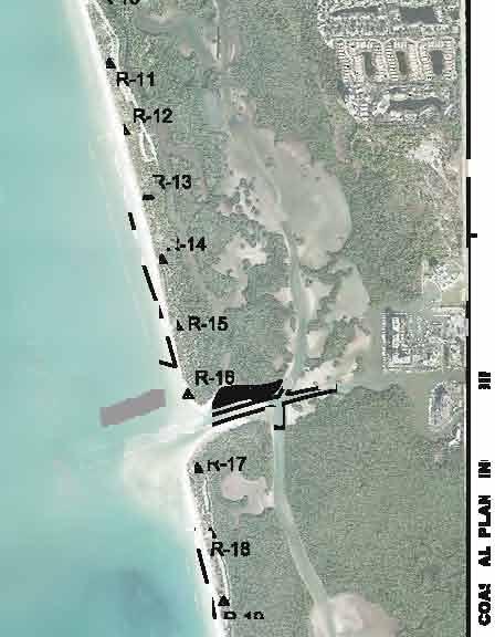
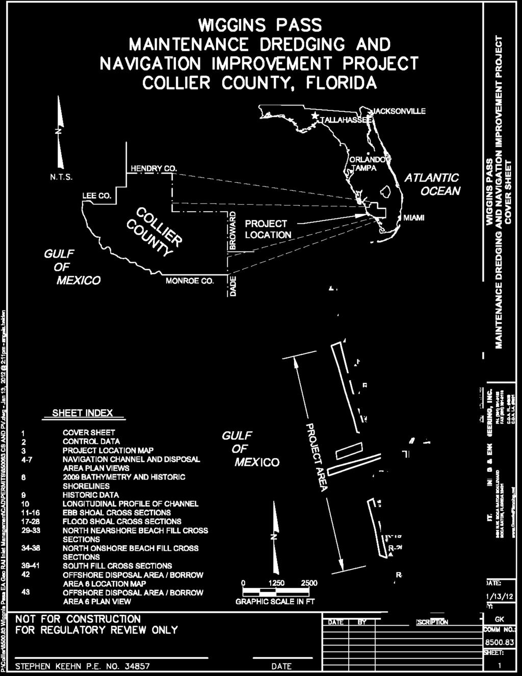
58 58 of 126
59 59 of 126
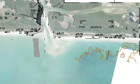

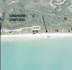
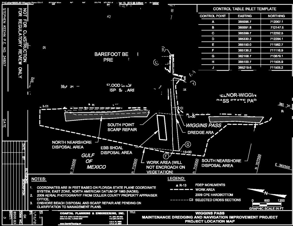
60 60 of 126

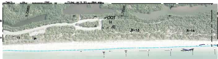

61 61 of 126
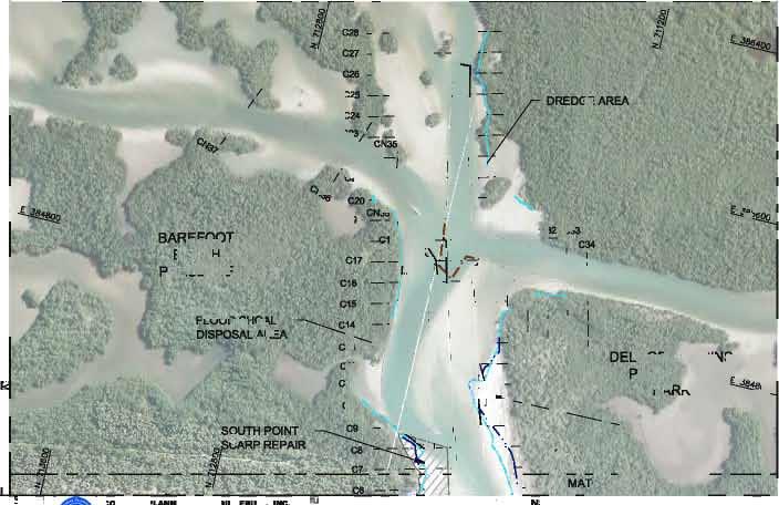
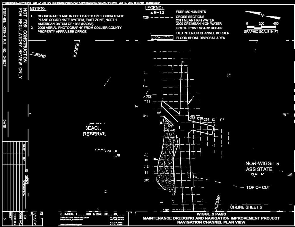
62 62 of 126


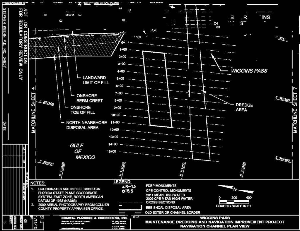
63 63 of 126


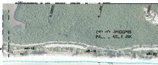

64 64 of 126
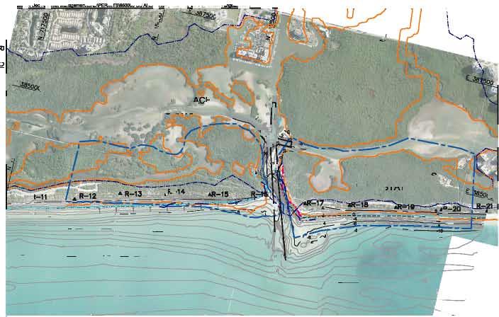
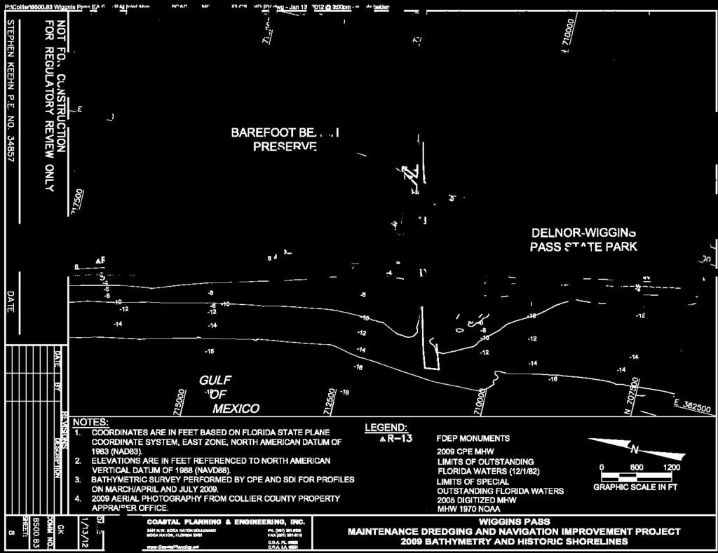
65 65 of 126

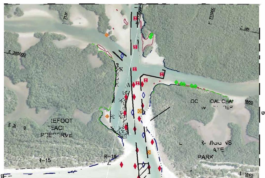


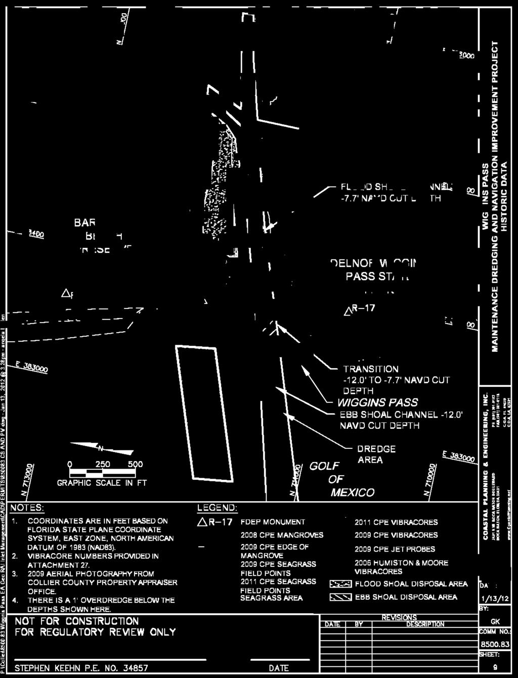
66 66 of 126
67 67 of 126
68 68 of 126
69 69 of 126
70 70 of 126
71 71 of 126
72 72 of 126
73 73 of 126
74 74 of 126
75 75 of 126
76 76 of 126

77 77 of 126
78 78 of 126
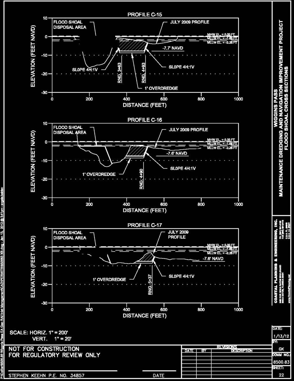
79 79 of 126
80 80 of 126
81 81 of 126
82 82 of 126
83 83 of 126
84 84 of 126
85 85 of 126
86 86 of 126
87 87 of 126
88 88 of 126
89 89 of 126
90 90 of 126
91 91 of 126
92 92 of 126
93 93 of 126
94 94 of 126
95 95 of 126
96 96 of 126
97 97 of 126
98 98 of 126
99 99 of 126

100 100 of 126
101 Attachment No. 25 Resource Map CAC - Wiggins Pass Subcommittee 101 of 126

. 2.")
102 Sheet 1a R-10 R-11 #0 #0 R-12 R-13 #0 Sheet 1c #0 R-14 Sheet 1d #0 R-15 # Sheet 1b Sheet 1e #0 R Sheet 1f CAC - Wiggins Pass Subcommittee 102 of Benthic Resource Map Wiggins Pass, Collier County, Florida TITLE: G:\Enterprise\Collier\143561_Wiggins_Pass_Channel_Straightening\_MXD\Benthic Habitat Index.mxd [ R-17 [ Sheet # g R-18 #0 Sheet 1h 1 inch = 1,400 feet R , Feet # Legend: #0 FDEP Monuments Notes: Sheet Index Sheet 1i 1. Coordinates are in feet based on the R Florida State Plane Coordinate System, # Sheet East Zone, North American Datum of 1j 1983 (NAD 83). 2. Aerial photography provided by R-22 Collier County, date flown #0 R #0 [ [ [ [ [ #0 R COASTAL PLANNING & ENGINEERING, INC. A SHAW GROUP COMPANY DATE: 09/30/11 BY: HMV COMM NO.: SHEET: 2481 N. W. BOCA RATON BOULEVARD PH. (561) BOCA RATON, FL FAX (561)

103 SHEET: BY: DATE: CAC - Wiggins Pass Subcommittee 103 of 126 LEGEND: 2009 Gopher Tortoise Burrow Survey Very Active Active Inactive Abandoned September 9, 2010 Hardbottom Observation R SSS Potential Hardbottom #I FDEP Monuments Gulf of Mexico #I Barefoot Beach Blvd Notes: 1. Coordinates are in feet based on Florida State Plane Coordinate System, East Zone, North American datum of 1983 (NAD 83). 2. County aerial photography provided by Collier County GIS Department, date flown Hardbottom investigation dive was performed by Pamela Keyes, Collier County Environmental Specialist on September 9, Matchline 1b Feet 1 inch = 200 feet 1a COMM NO.: HMV 09/29/11 COASTAL PLANNING & ENGINEERING, INC. A SHAW GROUP COMPANY 2481 N. W. BOCA RATON BOULEVARD BOCA RATON, FL PH (561) FAX (561) C.O.A. FL #4028 TITLE: Benthic Resource Map Wiggins Pass, Collier County, Florida


391-8102 FAX (561)391-9116 C.O.A. FL #4028 382299 382299 TITLE: 382799 R-12 #I 382799 Barefoot Beach Blvd.")
104 SHEET: BY: DATE: CAC - Wiggins Pass Subcommittee 104 of Gulf Feet of Mexico 1 inch = 200 feet Legend: Proposed Disposal Area 2009 Gopher Tortoise Burrow Survey Other 1b Very Active Active Inactive Abandoned Outstanding Florida Waters Special 1994 SSS Potential Hardbottom #I FDEP Monumnets Notes: Coordinates are in feet based on Florida State Plane Coordinate System, East Zone, North American datum of 1983 (NAD 83). 2. County aerial photography provided by Collier County GIS Department, date flown Wiggins Pass aerial photography flown by Aerial Cartographics of America, Inc., date flown September 25, COMM NO.: HMV 09/29/ Matchline 1a Matchline 1c COASTAL PLANNING & ENGINEERING, INC. A SHAW GROUP COMPANY 2481 N. W. BOCA RATON BOULEVARD BOCA RATON, FL PH (561) FAX (561) C.O.A. FL # TITLE: R-12 #I Barefoot Beach Blvd. Barefoot Beach Preserve County Park Benthic Resource Map Wiggins Pass, Collier County, Florida

. 2.")
105 SHEET: BY: DATE: CAC - Wiggins Pass Subcommittee 105 of 126 Matchline 1b Legend: Proposed Disposal Area 2009 Gopher Tortoise Burrow Survey Very Active Barefoot Beach Preserve Active County Park Inactive Abandoned Feet Outstanding Florida Waters Other inch = 200 feet R-13 #I Special #I FDEP Monuments Notes: c COMM NO.: HMV Gulf of Mexico 09/29/ COASTAL PLANNING & ENGINEERING, INC. A SHAW GROUP COMPANY 2481 N. W. BOCA RATON BOULEVARD BOCA RATON, FL PH (561) FAX (561) C.O.A. FL # TITLE: Matchline 1d Coordinates are in feet based on Florida State Plane Coordinate System, East Zone, North American datum of 1983 (NAD 83). 2. County aerial photography provided by Collier County GIS Department, date flown Wiggins Pass aerial photography flown by Aerial Cartographics of America, Inc., date flown September 25, Benthic Resource Map Wiggins Pass, Collier County, Florida


106 SHEET: BY: DATE: CAC - Wiggins Pass Subcommittee 106 of 126 R-14 Matchline 1c #I Feet inch = 200 feet Legend: Proposed Disposal Area 2009 Gopher Tortoise Burrow Survey Inactive Barefoot Abandoned Beach Other Special #I FDEP Monuments R-15 #I 1d Very Active Active Outstanding Florida Waters Notes: Coordinates are in feet based on Florida State Plane Coordinate System, East Zone, North American datum of 1983 (NAD 83). 2. County aerial photography provided by Collier County GIS Department, date flown Wiggins Pass aerial photography flown by Aerial Cartographics of America, Inc., date flown September 25, COMM NO.: HMV 09/29/ Gulf of Mexico Matchline 1e COASTAL PLANNING & ENGINEERING, INC. A SHAW GROUP COMPANY 2481 N. W. BOCA RATON BOULEVARD BOCA RATON, FL PH (561) FAX (561) C.O.A. FL # TITLE: Benthic Resource Map Wiggins Pass, Collier County, Florida


107 SHEET: BY: DATE: CAC - Wiggins Pass Subcommittee 107 of 126 Legend: Matchline 1df 2009 Gopher Tortoise Burrow Survey 2009 Edge of Mangrove Very Active Proposed Disposal Area Active 2011 Preliminary Alignment Inactive Outstanding Florida Waters Abandoned Other Feet 1 inch = 200 feet Special Notes: #I FDEP Monuments 1. Coordinates are in feet based on Florida State Plane Coordinate System, East Zone, North American datum of 1983 (NAD 83). 2. Wiggins Pass aerial photography flown by Aerial Cartographics of America, Inc., date flown September 25, Environmental field investigations performed by CPE on December 10, 2008, July 13 &14, 2009, and September 29, #I R Barefoot Beach Gulf of Mexico 1e Matchline 1g COMM NO.: HMV 09/30/ COASTAL PLANNING & ENGINEERING, INC. A SHAW GROUP COMPANY 2481 N. W. BOCA RATON BOULEVARD BOCA RATON, FL PH (561) FAX (561) C.O.A. FL # TITLE: Benthic Resource Map Wiggins Pass, Collier County, Florida Matchline 1f
 Proposed Disposal Area 2009 Seagrass (Halodule")
391-8102 FAX (561)391-9116 C.O.A. FL #4028 [ [ [ 385270 TITLE: Notes: 1.")
108 SHEET: BY: DATE: CAC - Wiggins Pass Subcommittee 108 of Barefoot Beach Matchline 1e Wiggins Pass [ [ Feet 1 inch = 200 feet Legend: Outstanding Florida Waters 2009 Seagrass Other Halophila decipiens 2009 Edge of Mangrove 2009 Oyster Beds 2011 Surveyed Seagrass (Halodule wrightii) Proposed Disposal Area 2009 Seagrass (Halodule wrightii) 2011 Preliminary Alignment [ 2008 Surveyed Seagrass Matchline 1g 1f COMM NO.: HMV 09/29/11 Delnor-Wiggins Pass State Recreational Area COASTAL PLANNING & ENGINEERING, INC. A SHAW GROUP COMPANY 2481 N. W. BOCA RATON BOULEVARD BOCA RATON, FL PH (561) FAX (561) C.O.A. FL #4028 [ [ [ TITLE: Notes: 1. Coordinates are in feet based on Florida State Plane Coordinate System, East Zone, North American datum of 1983 (NAD 83). 2. Wiggins Pass aerial photography flown by Aerial Cartographics of America, Inc., date flown September 25, Environmental field investigations performed by CPE on December 10, 2008 July 13 &14, 2009 and September 29, Benthic Resource Map Wiggins Pass, Collier County, Florida
109 SHEET: BY: DATE: CAC - Wiggins Pass Subcommittee 109 of 126 Legend: August 2009 SSS Hardbottom Edge Proposed Disposal Area Outstanding Florida Waters Other Special #I FDEP Monuments Notes: Matchline 1g Coordinates are in feet based on Florida State Plane Coordinate System, East Zone, North American datum of 1983 (NAD 83). 2. Wiggins Pass aerial photography flown by Aerial Cartographics of America, Inc., date flown September 25, R-18 Delnor-Wiggins Pass State Recreational Area #I Gulf of Mexico Feet 1 inch = 200 feet R-19 #I 1h Matchline 1i HMV COMM NO.: 09/29/ COASTAL PLANNING & ENGINEERING, INC. A SHAW GROUP COMPANY 2481 N. W. BOCA RATON BOULEVARD BOCA RATON, FL PH (561) FAX (561) C.O.A. FL # TITLE: Benthic Resource Map Wiggins Pass, Collier County, Florida


110 SHEET: BY: DATE: CAC - Wiggins Pass Subcommittee 110 of 126 Legend: August 2009 SSS Hardbottom Edge Proposed Disposal Area Outstanding Florida Waters Other Special #I FDEP Monuments Notes: Coordinates are in feet based on Florida State Plane Coordinate System, East Zone, North American datum of 1983 (NAD 83). 2. Wiggins Pass aerial photography flown by Aerial Cartographics of America, Inc., date flown September 25, Matchline 1h Delnor-Wiggins Pass State Recreational Area R-20 #I Gulf of Mexico Feet 1 inch = 200 feet 1i Matchline 1j HMV COMM NO.: 09/29/ COASTAL PLANNING & ENGINEERING, INC. A SHAW GROUP COMPANY 2481 N. W. BOCA RATON BOULEVARD BOCA RATON, FL PH (561) FAX (561) C.O.A. FL # TITLE: Benthic Resource Map Wiggins Pass, Collier County, Florida
. 2.")

111 SHEET: BY: DATE: CAC - Wiggins Pass Subcommittee 111 of 126 Legend: August 2009 SSS Hardbottom Edge Outstanding Florida Waters Matchline 1g Delnor-Wiggins Pass State Recreational Area Other Special #I FDEP Monuments R-18 #I Notes: Coordinates are in feet based on Florida State Plane Coordinate System, East Zone, North American datum of 1983 (NAD 83). 2. Wiggins Pass aerial photography flown by Aerial Cartographics of America, Inc., date flown September 25, Gulf of Mexico Feet 1 inch = 200 feet R-19 #I 1h Matchline 1i HMV COMM NO.: 09/29/ COASTAL PLANNING & ENGINEERING, INC. A SHAW GROUP COMPANY 2481 N. W. BOCA RATON BOULEVARD BOCA RATON, FL PH (561) FAX (561) C.O.A. FL # TITLE: Benthic Resource Map Wiggins Pass, Collier County, Florida
112 112 of 126 Attachment No Geotechnical Report (Previously Submitted to Collier County)
113 Attachment No Benthic Resource Survey for Wiggins Pass (Originally submitted as Appendix 28-1) Electronic Submittal CAC - Wiggins Pass Subcommittee 113 of 126
114 Attachment No CAC - Wiggins Pass Subcommittee 114 of 126
115 115 of 126 MEMORANDUM To: Valdimir Kosmynin, Ph.D., FDEP Comm No.: From: Pamela Keyes, Environmental Specialist, Collier County Date: September 9, 2010 Re: Wiggins Pass Hardbottom Mapping Below is a summary from the hardbottom investigation dive performed on September 8, Attached is map of the transect lines as well as the corresponding GPS points. We dove R , R-11, R , and R-12. The transects were all 600 long and located 400 feet offshore. The visibility was in the one foot range so we were not able to get any video. R From the out point to 100 before the mid point hardbottom was found. Immediately following the hardbottom approximately 4 inch thick mud was found for the rest of the transect. R-11 Hardbottom was found from the out point to 75 past the mid point. This included one foot of relief. Immediately following the hardbottom mud approximately 4 thick was found throughout the rest of the transect. R No hardbottom was found and most of the transect was covered in mud. R-12 No hardbottom was found and most of the transect was covered in mud.

116 Hardbottom Investigation Points CAC - Wiggins Pass Subcommittee 116 of 126
117 117 of 126 Attachment No. 33a Engineering Report (Previously Submitted to Collier County)
118 118 of 126 Attachment No. 33d Request for Temporary Mixing Zone and Degradation Variance for the Wiggins Pass Maintenance Dredging Project
119 119 of 126 Temporary Mixing Zone Variance Collier County: Wiggins Pass Maintenance Dredging JCP January 13, 2012 Mixing Zone Variance Request This is to request a mixing zone and degradation variance from the provisions of Rule (5)(c), F.A.C. to be granted for the Collier County Wiggins Pass Interim Dredging Project. We request a temporary mixing zone of 450 meters offshore and 450 meters down-current from the disposal and dredge area into the Gulf of Mexico and Wiggins Pass with an allowable turbidity of 29 NTUs outside of OFW and 10 NTUs within OFW or at hardbottom or vegetation sites. This variance is being requested for a duration of 150 days during initial construction and 45 days for maintenance dredging. The period is requested to account for anticipated construction time and operational and weather delays. Mixing Zone Variance Justification The primary justification for the mixing zone variance request is that there is no practical means of maintaining project related turbidity within the standard 150 meter mixing zone, especially in an open body of water such as the Gulf of Mexico where patches of OFW are at the shoreline. Depending on wave and current conditions, a major sediment dredging project such as a maintenance dredging, with sediment placement, requires a larger mixing zone then the standard 150 meter mixing zone. At times, conditions may exist that cause localized turbidity at the Gulf of Mexico disposal site to temporarily exceed water quality standards beyond the standard 150 meter zone. For example, wave activity during project construction may retain fine sediment in suspension and establish longshore currents, resulting in turbidity spread along the coastline beyond the standard 150 meter mixing zone. Standard measures such as turbidity curtains will not properly function in an open coastal setting. The ebb shoal dredge area is below the State limit for silt and clay content (~1%). The majority of the proposed flood shoal dredge area has a silt and clay content well below the State (FDEP) limit of 10% defined for beach and nearshore fill projects. There are smaller areas with fines between 10% and 20% and clay. However, it is anticipated that the dredging activities may introduce sufficient material volume to exceed the standard mixing zone and be above the 0 NTU requirement for OFW, especially given the scattered patches of OFW wet regions. Water quality monitoring conducted for construction of this project, most recently from February to March 2009 and February to March 2011, has shown slightly elevated turbidity at the edge of the mixing zone. Data in 2009 have shown that turbidity at the edge of the mixing zone by the disposal area was, on average, 8.0 NTU above background levels with a standard deviation of 1.3, and a maximum of 11.0 NTU above background levels. Turbidity at the edge of the mixing zone around the borrow area was,
120 120 of 126 on average, 8.5 NTU above background levels with a standard deviation of 1.0, and a maximum of 10.6 NTU above background levels. During the 2011 project, the maximum turbidity was about the same at 10.3 NTU, while the average reduced to 3.8 NTU. This information is listed below in Tables 1 and 2. In addition, patches of OFW exist seaward of Barefoot Beach Park and Delnor-Wiggins State Park, and they are within the mixing zone distance where historical turbidity measures of 11.0 NTU were taken (see below). Table Historic Turbidity Difference Measurements Date Dig Disposal Mid Bottom Mid Bottom 12-Feb Feb Feb Feb Feb Feb Feb Feb Feb Feb Feb Feb Feb Feb Feb Feb Feb Feb Feb Feb Feb Feb Feb Feb Mar Mar Mar Mar Mar Mar Mar Max 10.6 Max 11 Avg Avg Std Std
121 121 of 126 Table Turbidity Difference Measurements Date Dredge Disposal Surface Mid Depth Surface Mid Depth /25/ /26/ /27/ /28/ /1/ /3/ /4/ /5/ /6/ /8/ /9/2011 3/12/ /13/ /14/ /15/ Max Max. 9.6 Avg Avg Std Std
122 122 of 126 As an additional pre-caution, turbidity curtains are proposed in two areas. These areas should have low currents, since they are at the sides of channels protecting habitat. If currents prove too strong, the curtains will be removed. The curtains will be used when dredge and fill operations occur adjacent to the area and are marked by a T on the enclosed figure. A secondary pre-caution may be dredging only on the outgoing tide, if the turbidity standards cannot be maintained inside the inlet. This may not be effective since some areas in the inlet are more than 450 m from the Gulf. Summary Collier County requests the granting of a mixing zone variance of 450 meters offshore and 450 meters down-current from the dredge and disposal areas into the Gulf of Mexico for a duration of 45 days from the start of excavation, or until the permitted construction period ends (prior to the start of sea turtle nesting) for maintenance dredging and 150 days for initial construction. The requested turbidity requirements for these areas are proposed to be 29 NTUs outside of OFW and 10 NTUs within OFW. Additionally, the nearest hardbottom point and patch of seagrasses will be monitored when within 450 meters of dredging.
. 2. DATE OF AERIAL PHOTOGRAPHY: 2009.")


123 ( CAC - Wiggins Pass Subcommittee 123 of 126 # 0 ( T # 0 # 0 # 0 # 0 # 0 # 0 # 0 # 0 R-15 # 0 IN R-16 S PA # 0 G R-20 R-19 R-18 R-17 SS R-14 R-13 R-12 R-11 R-10 R-9 GULF OF MEXICO NOTES: 1. COORDINATES ARE IN FEET BASED ON THE FLORIDA STATE PLANE COORDINATE SYSTEM, EAST ZONE,NORTH AMERICAN DATUM OF (NAD83). 2. DATE OF AERIAL PHOTOGRAPHY: TITLE: LEGEND: T ( 2011 SURVEYED SEAGRASS (HALODULE WRIGHTII) ALONG SHORE TURBIDITY SCREEN PROPOSED DREDGE TEMPLATE 2009 SEAGRASS # 0 FDEP MONUMENTS HALODULE WRIGHTII DISPOSAL AREAS 450 M MIXING ZONEE NATURAL RESOURCE MAP WITH MIXING ZONES WIGGINS PASS, COLLIER COUNTY, FLORIDA OUTSTANDING FLORIDA WATERS (! G:\Enterprise\Collier\143561_Wiggins_Pass_Channel_Straightening\_MXD\Natural_Resource_with_Mixing_Zoning_ mxd W IG # 0 T HALOPHILA DECIPIENS AUGUST 2009 SSS HARDBOTTOM 2009 EDGE OF MANGROVE 1994 CPE SSS AND DIVER INVESTIGATED POTENTIAL HARDBOTTOM 2009 OYSTER BEDS Feet 800 COASTAL PLANNING & ENGINEERING, INC. A SHAW GROUP COMPANY 2481 N. W. BOCA RATON BOULEVARD BOCA RATON, FL PH. (561) FAX (561) inch = 800 feet Date: 01/11/12 By: HMV Comm No. : Figure
ATTACHMENT 2 PROJECT NEED AND JUSTIFICATION
 ATTACHMENT 2 PROJECT NEED AND JUSTIFICATION INTRODUCTION The Project includes providing erosion control and shoreline stabilization measures including beach nourishment, maintenance dredging and bypassing,
Conceptual Engineering Report Collier County Beaches, Florida
 Conceptual Engineering Report Collier County Beaches, Florida Presented to Collier County Coastal Advisory Committee October 13, 2011 Steve Keehn, PE, CPE Topics Goals Monitoring & Performance Summary
SEDIMENT QUALITY CONTROL/QUALITY ASSURANCE PLAN FOR BEACH RESTORATION OR NOURISHMENT USING AN OFFSHORE BORROW AREA. [FDEP Permit No.
 SEDIMENT QUALITY CONTROL/QUALITY ASSURANCE PLAN FOR BEACH RESTORATION OR NOURISHMENT USING AN OFFSHORE BORROW AREA [FDEP Permit No.] Palm Beach Co Department of Environment Resources Management Jupiter/Carlin
SEDIMENT QUALITY CONTROL/QUALITY ASSURANCE PLAN FOR BEACH RESTORATION OR NOURISHMENT USING AN OFFSHORE BORROW AREA. [FDEP File No.
 SEDIMENT QUALITY CONTROL/QUALITY ASSURANCE PLAN FOR BEACH RESTORATION OR NOURISHMENT USING AN OFFSHORE BORROW AREA [FDEP File No. 0307741-002-JC] USACE DADE COUNTY BEC & HP CONTRACT G May 2012 A. INTRODUCTION
PUBLIC NOTICE NO. FP13-AB03-05 August 30, 2013 CESAM-PD-EC JOINT PUBLIC NOTICE
 DEPARTMENT OF THE ARMY MOBILE DISTRICT, CORPS OF ENGINEERS P.O. BOX 2288 MOBILE, ALABAMA 36628-0001 REPLY TO ATTENTION OF: JOINT PUBLIC NOTICE U. S. ARMY CORPS OF ENGINEERS, MOBILE DISTRICT AND FLORIDA
U.S. Army Corps of Engineers Jacksonville District Sediment Quality Control/Quality Assurance Plan For Maintenance Dredging with Beach Placement
 U.S. Army Corps of Engineers Jacksonville District Sediment Quality Control/Quality Assurance Plan For Maintenance Dredging with Beach Placement Name of Project: Maintenance Dredging AIWW Vicinity Jupiter
SEDIMENT QUALITY ASSURANCE/QUALITY CONTROL PLAN DUVAL COUNTY BEACH NOURISHMENT PROJECT. FDEP Permit No JC
 SEDIMENT QUALITY ASSURANCE/QUALITY CONTROL PLAN DUVAL COUNTY BEACH NOURISHMENT PROJECT FDEP Permit No. 0228528-005-JC PERMITTEE: City of Jacksonville, Florida 20 July 2015 A. INTRODUCTION The project will
USACE (IP-SLN)
") Broward County Shore, Segment III, Protection Project, FDEP Permit #0163435-001-JC FDEP Permit #0163435-009-JC FDEP Permit #0226688-001-JC USACE Permit 1999-5545 (IP-SLN) Sand Quality Control and Quality
Broward County Shore, Segment III, Protection Project, FDEP Permit #0163435-001-JC FDEP Permit #0163435-009-JC FDEP Permit #0226688-001-JC USACE Permit 1999-5545 (IP-SLN) Sand Quality Control and Quality
Town of Duck North Carolina
 Town of Duck North Carolina Town of Duck Shore Protection Project Photograph obtained by. (July 7. 2017). Beach Maintenance Plan August 2017 Prepared By:. 4038 Masonboro Loop Road Wilmington, NC 28409
APPENDIX I DRAFT COMPENSATORY MITIGATION PLAN
 APPENDIX I DRAFT COMPENSATORY MITIGATION PLAN This page intentionally left blank. SOUTHERN PALM BEACH ISLAND COMPREHENSIVE SHORELINE STABILIZATION PROJECT DRAFT COMPENSATORY MITIGATION PLAN TABLE OF CONTENTS
APPENDIX A SECTION 404(B)(1) EVALUATION TYBEE ISLAND, GEORGIA SHORE PROTECTION PROJECT RENOURISHMENT
(1) EVALUATION TYBEE ISLAND, GEORGIA SHORE PROTECTION PROJECT RENOURISHMENT") APPENDIX A SECTION 404(B)(1) EVALUATION TYBEE ISLAND, GEORGIA SHORE PROTECTION PROJECT 2014-2015 RENOURISHMENT U.S. ARMY CORPS OF ENGINEERS SAVANNAH DISTRICT JUNE 2014 This page intentionally blank. SECTION
APPENDIX A SECTION 404(B)(1) EVALUATION TYBEE ISLAND, GEORGIA SHORE PROTECTION PROJECT 2014-2015 RENOURISHMENT U.S. ARMY CORPS OF ENGINEERS SAVANNAH DISTRICT JUNE 2014 This page intentionally blank. SECTION
Final General Reevaluation Report and Final Environmental Impact Statement. Hurricane Protection and Beach Erosion Control
 Final General Reevaluation Report and Final Environmental Impact Statement on Hurricane Protection and Beach Erosion Control WEST ONSLOW BEACH AND NEW RIVER INLET (TOPSAIL BEACH), NORTH CAROLINA Appendix
MEETING AGENDA ALTERNATIVE SAND SOURCE INVESTIGATION DADE COUNTY, FLORIDA BEACH EROSION CONTROL & HURRICANE PROTECTION PROJECT
 ALTERNATIVE SAND SOURCE INVESTIGATION DADE COUNTY, FLORIDA BEACH EROSION CONTROL & HURRICANE PROTECTION PROJECT MEETING AGENDA Draft Environmental Assessment Poster Session: 6:30 6:45 Presentation 6:45
Tampa Port Authority
 McKay Bay Restoration (McKay Bay Mitigation Site and McKay Bay Dredge Hole Restoration) Tampa Port Authority 2014 AAPA Environmental Awards Competition June 2014 Contact: Andy Fobes, Director of Public
July 22, Dear Mr. Garis:
 Gregory W. Garis Environmental Specialist III Department of Environmental Protection Beaches, Inlets, and Ports 2600 Blair Stone Road, Mail Station 3544 Tallahassee, Florida 32399-3000 (850) 245-8280 Response
DEPARTMENT OF THE ARMY CORPS OF ENGINEERS, MOBILE DISTRICT P.O. BOX 2288 MOBILE, AL
 DEPARTMENT OF THE ARMY CORPS OF ENGINEERS, MOBILE DISTRICT P.O. BOX 2288 MOBILE, AL 36628-0001 CESAM RD-A April 15, 2018 PUBLIC NOTICE NO. SAM-2018-01191-DCH JOINT PUBLIC NOTICE U.S. ARMY CORPS OF ENGINEERS
Town of Duck North Carolina
 Town of Duck North Carolina Town of Duck Shore Protection Project Photograph obtained by. (July 7, 2017). Beach Maintenance Plan August 2017 Updated September 2018 Prepared By:. 4038 Masonboro Loop Road
SANDY HOOK CHANNEL, NEW YORK HARBOR FEDERAL NAVIGATION PROJECT MAINTENANCE DREDGING
 Public Notice In replying refer to: Public Notice No. Sandy Hook Channel, NY Harbor FY17 Published: 14 February 2017 Expires: 14 March 2017 New York District 26 Federal Plaza New York, N.Y. 10278 ATTN:
MARTIN COUNTY, FLORIDA INTER-OFFICE MEMORANDUM To the Honorable Board of County DATE: August 14, 2015
 TO: MARTIN COUNTY, FLORIDA INTER-OFFICE MEMORANDUM To the Honorable Board of County DATE: August 14, 2015 Commissioners VIA: Taryn Kryzda, County Administrator FROM: SUBJECT: Don Donaldson, P.E. Engineering
Maria W. Merrill Florida Fish and Wildlife Conservation Commission Aquatic Habitat Conservation and Restoration Section April 12, 2013
 Maria W. Merrill Florida Fish and Wildlife Conservation Commission Aquatic Habitat Conservation and Restoration Section April 12, 2013 Focus Region 16 Coastal counties from Perdido Key east to Anclote
APPLICANT: Decatur Head Beach Association 1327 Decatur Head Drive Decatur Island Anacortes, WA Telephone: (425)
") US Army Corps of Engineers Seattle District Joint Public Notice Application for a Department of the Army Permit and a Washington Department of Ecology Water Quality Certification and/or Coastal Zone Management
US Army Corps of Engineers Seattle District Joint Public Notice Application for a Department of the Army Permit and a Washington Department of Ecology Water Quality Certification and/or Coastal Zone Management
REQUIRED INFORMATION Please check the following boxes that apply to your lot or parcel and complete the other requested information.
 MARTIN COUNTY EXCAVATION AND FILL PERMIT APPLICATION This application to be used only for excavating or filling activities not associated with a building permit or development review and for projects requiring
U.S. ARMY CORPS OF ENGINEERS BUILDING STRONG LOS ANGELES DISTRICT
 PUBLIC NOTICE U.S. ARMY CORPS OF ENGINEERS BUILDING STRONG LOS ANGELES DISTRICT APPLICATION FOR PERMIT City of Oceanside Opportunistic Beach Fill Program (OBFP) Public Notice/Application No.: SPL-2014-00271-RRS
THIS IS NOT A PAID ADVERTISEMENT. Public Notice. Public Notice No. CENAP-OP-R February 2, 2018
 THIS IS NOT A PAID ADVERTISEMENT Public Notice Wanamaker Building 100 Penn Square East Philadelphia, PA 19107-3390 ATTN: CENAP-OP-R Public Notice No. Date CENAP-OP-R-2015-1060-24 February 2, 2018 Application
James Gray M.S. Tem Fontaine M.S., P.E.
 2012 FSBPA Annual Conference September 28, 2012 Indian River County - Sector 3 Beach and Dune Restoration Project Summary and Perspectives Using an Upland Sand Source James Gray M.S. Tem Fontaine M.S.,
Take Notice that the National Oceanic and Atmospheric Administration s (NOAA)
") NEW JERSEY DEPARTMENT OF ENVIRONMENTAL PROTECTION LAND USE MANAGEMENT Division of Policy Implementation Notice of Determination on Routine Program Change to New Jersey Coastal Management Program Take Notice
NEW JERSEY DEPARTMENT OF ENVIRONMENTAL PROTECTION LAND USE MANAGEMENT Division of Policy Implementation Notice of Determination on Routine Program Change to New Jersey Coastal Management Program Take Notice
VILLAGE OF BALD HEAD ISLAND SHORELINE PROTECTION PROJECT DRAFT ENVIRONMENTAL IMPACT STATEMENT
 VILLAGE OF BALD HEAD ISLAND SHORELINE PROTECTION PROJECT DRAFT ENVIRONMENTAL IMPACT STATEMENT Prepared By: U.S. Army Corps of Engineers Wilmington District and Land Management Group, Inc. (Third Party
ENVIRONMENTAL RESTORATION IN COASTAL MISSISSIPPI: MARSH RE-ESTABLISHMENT PROJECT HARRISON AND JACKSON COUNTIES, MISSISSIPPI
 SECTION 404(b)(1) EVALUATION REPORT FOR THE SECTION 204 ECOSYSTEM RESTORATION PROJECT IN CONNECTION WITH CONSTRUCTION, OPERATION, OR MAINTENANCE DREDGING OF A FEDERALLY AUTHORIZED PROJECT ENVIRONMENTAL
2. Does not require, involve or include any additions to, or repair or modification of, the existing foundation.
 SECTION 3109 STRUCTURES SEAWARD OF A COASTAL CONSTRUCTION CONTROL LINE 3109.1 General. The provisions of this section shall apply to the design and construction of habitable structures, and substantial
New Jersey Department of Environmental Protection
 New Jersey Department of Environmental Protection Assistant Commissioner Marilyn Lennon Land Use Management Division of Land Use Regulation Manager Virginia Kopkash September 16, 2013 Transformation of
Joint Public Notice Application for a Department of the Army Permit and an Environmental Protection Agency Water Quality Certification
 US Army Corps of Engineers Seattle District Joint Public Notice Application for a Department of the Army Permit and an Environmental Protection Agency Water Quality Certification US Army Corps of Engineers
Florida Department of Environmental Protection Florida Surface Water Quality Antidegradation Policies, with Emphasis on Application to Wetlands
 Florida Department of Environmental Protection Florida Surface Water Quality Antidegradation Policies, with Emphasis on Application to Wetlands Prepared by: Florida Department of Environmental Protection
Appendix D 404(b) Analysis
 Analysis") Appendix D 404(b) Analysis Appendix D - Evaluation of Section 404(b)(1) Guidelines I. Project Description A. Location: Delaware Bay and bayshore communities (Pickering Beach, Kitts Hummock, Bowers Beach,
Appendix D 404(b) Analysis Appendix D - Evaluation of Section 404(b)(1) Guidelines I. Project Description A. Location: Delaware Bay and bayshore communities (Pickering Beach, Kitts Hummock, Bowers Beach,
Errata sheet for the Connecticut General Permits May 2, 2017
 Errata sheet for the Connecticut General Permits May 2, 2017 The Corps of Engineers, New England District, has compiled this list of corrections and clarifications for the Connecticut General Permits that
ENVIRONMENTAL RESOURCE PERMIT APPLICATION
 ENVIRONMENTAL RESOURCE PERMIT APPLICATION SOUTHWEST FLORIDA WATER MANAGEMENT DISTRICT 2379 BROAD STREET, BROOKSVILLE, FL 34604-6899 (352) 796-7211 OR FLORIDA WATS 1 (800) 423-1476 SECTION E INFORMATION
02 APRIL PUBLIC NOTICE U.S. Army Corps of Engineers, Savannah District
 DEPARTMENT OF THE ARMY U.S. ARMY CORPS OF ENGINEERS, SAVANNAH DISTRICT 100 W. OGLETHORPE AVENUE SAVANNAH, GEORGIA 31401-3604 Planning Branch TO WHOM IT MAY CONCERN: 02 APRIL 2019 PUBLIC NOTICE U.S. Army
Request for a Proposal The Bolsa Chica Lowlands Restoration Project: Sustainability Alternatives Study January 2019
 Request for a Proposal The Bolsa Chica Lowlands Restoration Project: Sustainability Alternatives Study January 2019 Introduction The Bolsa Chica Land Trust (BCLT) has applied for and been selected to receive
Errata sheet for the Connecticut General Permits March 26, 2019
 Errata sheet for the Connecticut General Permits March 26, 2019 The Corps of Engineers, New England District, has compiled this list of corrections and clarifications for the Connecticut General Permits
J O I N T P U B L I C N O T I C E
 J O I N T P U B L I C N O T I C E CHARLESTON DISTRICT, CORPS OF ENGINEERS 69A Hagood Avenue Charleston, SC 2943-517 and THE S.C. DEPARTMENT OF HEALTH AND ENVIRONMENTAL CONTROL Office of Ocean and Coastal
U.S. ARMY CORPS OF ENGINEERS BUILDING STRONG LOS ANGELES DISTRICT
 PUBLIC NOTICE U.S. ARMY CORPS OF ENGINEERS BUILDING STRONG LOS ANGELES DISTRICT APPLICATION FOR PERMIT RE-ISSUANCE PROTECTIVE SAND BERM AT CARPINTERIA CITY BEACH Public Notice/Application No.: SPL-2014-00508-CLH
DRAFT SECTION 404(b)(1) EVALUATION REPORT CONTINUED MAINTENANCE DREDGING OF THE FEDERALLY AUTHORIZED EASTPOINT NAVIGATION PROJECT
(1) EVALUATION REPORT CONTINUED MAINTENANCE DREDGING OF THE FEDERALLY AUTHORIZED EASTPOINT NAVIGATION PROJECT") DRAFT SECTION 404(b)(1) EVALUATION REPORT CONTINUED MAINTENANCE DREDGING OF THE FEDERALLY AUTHORIZED EASTPOINT NAVIGATION PROJECT FRANKLIN COUNTY, FLORIDA I. PROJECT DESCRIPTION: A. Location: The federally
DRAFT SECTION 404(b)(1) EVALUATION REPORT CONTINUED MAINTENANCE DREDGING OF THE FEDERALLY AUTHORIZED EASTPOINT NAVIGATION PROJECT FRANKLIN COUNTY, FLORIDA I. PROJECT DESCRIPTION: A. Location: The federally
CHAPTER 62B-34 GENERAL PERMITS FOR ACTIVITIES SEAWARD OF THE COASTAL CONSTRUCTION CONTROL LINE
 1 2 CHAPTER 62B-34 GENERAL PERMITS FOR ACTIVITIES SEAWARD OF THE COASTAL CONSTRUCTION CONTROL LINE 3 4 5 6 7 8 9 10 11 12 13 14 15 62B-34.010 62B-34.030 62B-34.040 62B-34.050 62B-34.055 62B-34.060 62B-34.070
Sebastian Inlet Channel Completion Project
 Sebastian Inlet Channel Completion Project Comprehensive Seagrass Mitigation and Monitoring Program Presented by Adam Gelber A Project for Martin S. Smithson Sebastian Inlet District Sebastian Inlet, FL
Maine s Coastal Sand Dune Rules
 Maine s Coastal Sand Dune Rules July 2017 David Cherry Project Manager Land Division Southern Maine Regional Office Protecting Maine s Air, Land and Water Sand dune systems are mapped by the Maine Geological
LEE COUNTY, FLORIDA GASPARILLA ISLAND SEGMENT SHORE PROTECTION PROJECT 2013 BEACH RENOURISHMENT POST CONSTRUCTION MONITORING REPORT.
 LEE COUNTY, FLORIDA GASPARILLA ISLAND SEGMENT SHORE PROTECTION PROJECT 2013 BEACH RENOURISHMENT POST CONSTRUCTION MONITORING REPORT August 2014 U.S. ARMY CORPS OF ENGINEERS JACKSONVILLE DISTRICT Table
Encinitas-Solana Beach Coastal Storm Damage Reduction Project. San Diego County, California. Appendix D. 404(b)(1) Evaluation
(1) Evaluation") 1 2 3 4 5 6 7 8 9 10 Encinitas-Solana Beach Coastal Storm Damage Reduction Project San Diego County, California Appendix D 404(b)(1) Evaluation 11 12 13 14 15 16 17 U.S. Army Corps of Engineers Los Angeles
1 2 3 4 5 6 7 8 9 10 Encinitas-Solana Beach Coastal Storm Damage Reduction Project San Diego County, California Appendix D 404(b)(1) Evaluation 11 12 13 14 15 16 17 U.S. Army Corps of Engineers Los Angeles
30 DAY PUBLIC NOTICE MAINTENANCE DREDGING OF THE PLYMOUTH HARBOR FEDERAL NAVIGATION PROJECT PLYMOUTH, MASSACHUSETTS
 696 Virginia Road Concord, MA 01742-2751 Public Notice In Reply Refer to: Mr. Michael Walsh nae-pn-nav@usace.army.mil Programs & Project Management Division Date: June 14, 2018 Comment Period Closes: July
AMENDMENTS TO BAYFIELD COUNTY ZONING ORDINANCE. Lake Superior Shoreland Lot Development Requirements.
 AMENDMENTS TO BAYFIELD COUNTY ZONING ORDINANCE Sec. 13-1-34 is created to read as follows: Sec. 13-1-34 Lake Superior Shoreland Lot Development Requirements. Introduction. Much of Bayfield County s Lake
CESAM-RD-A December 4, 2017 PUBLIC NOTICE NO. SAM SBC
 DEPARTMENT OF THE ARMY MOBILE DISTRICT, CORPS OF ENGINEERS P.O. BOX 2288 MOBILE, AL 36628-0001 PUBLIC NOTICE NO. SAM-2017-01123-SBC JOINT PUBLIC NOTICE U.S. ARMY CORPS OF ENGINEERS AND STATE OF ALABAMA
GRADING, FILL, EXCAVATION AND LANDSCAPING 2012 EDITION
 CHAPTER 23.105 GRADING, FILL, EXCAVATION AND LANDSCAPING 2012 EDITION Sections 23.105.101 General... 1 23.105.102 Definitions... 1 23.105.103 Permits required... 3 23.105.104 Hazards.... 4 23.105.105 Permit
Maine s Land Use Regulations and Erosion Control Techniques
 Maine s Land Use Regulations and Erosion Control Techniques Protecting Maine s Air, Land and Water Colin Clark 441-7419 colin.a.clark@maine.gov Tom Gilbert 441-8031 thomas.gilbert@maine.gov Jim Rodrigue
Shrewsbury River Basin, Sea Bright, New Jersey Coastal Storm Risk Management Feasibility Study
 Shrewsbury River Basin, Sea Bright, New Jersey Coastal Storm Risk Management Feasibility Study Draft Integrated Feasibility Report & Environmental Assessment Appendix E: Pertinent Correspondence & Environmental
PUBLIC NOTICE. Dredge, with 10-years maintenance, and placement of sand on an adjacent beach
 PUBLIC NOTICE US Army Corps of Engineers New York District Jacob K. Javits Federal Building New York, N.Y. 10278-0090 ATTN: Regulatory Branch In replying refer to: Public Notice Number: NAN-2017-00816-EKN
COASTAL SHORE PROTECTION WITH LIVING SHORELINES
 COASTAL SHORE PROTECTION WITH LIVING SHORELINES Role of the Army Corps Regulatory Program UCONN, Clear Living Shorelines II Workshop June 24, 2015 Groton CT Cori M. Rose Senior Project Manager/PWS cori.m.rose@usace.army.mil
Public Information Meeting 7 MARCH 2017
 Public Information Meeting 7 MARCH 2017 Outline of the Presentation Overview of the project Key dates and milestones Anticipated construction Timetable & Activities Required sea turtle monitoring during
Environmental Assessment Appendix H: Section 404(b)(1) Guidelines Evaluation. U.S. Army Corps of Engineers New York District
(1) Guidelines Evaluation. U.S. Army Corps of Engineers New York District") Environmental Assessment Appendix H: Section 404(b)(1) Guidelines Evaluation U.S. Army Corps of Engineers New York District January 2004 APPENDIX H SECTION 404(b)(1) GUIDELINES EVALUATION SECTION 404(b)(1)
Environmental Assessment Appendix H: Section 404(b)(1) Guidelines Evaluation U.S. Army Corps of Engineers New York District January 2004 APPENDIX H SECTION 404(b)(1) GUIDELINES EVALUATION SECTION 404(b)(1)
Chapter 4. Drainage Report and Construction Drawing Submittal Requirements
 4.0 Introduction The requirements presented in this section shall be used to aid the design engineer or applicant in the preparation of drainage reports, drainage studies, and construction drawings for
Appendix 1 CWA Section 404 Compliance Forms Section 404(b)(1) Guideline Short Form and Coastal Zone Consistency
(1) Guideline Short Form and Coastal Zone Consistency") Appendix 1 CWA Section 404 Compliance Forms Section 404(b)(1) Guideline Short Form and Coastal Zone Consistency HSC PDR for HSC Flare at Bayport Ship Channel Environmental Assessment This page left intentionally
Appendix 1 CWA Section 404 Compliance Forms Section 404(b)(1) Guideline Short Form and Coastal Zone Consistency HSC PDR for HSC Flare at Bayport Ship Channel Environmental Assessment This page left intentionally
CHAPTER 7. San Dieguito River Flooding Adaptation
 CHAPTER 7 San Dieguito River Flooding Adaptation This chapter includes a range of adaptation measures to address vulnerabilities from flooding along the San Dieguito River, including the river valley,
Florida Department of Environmental Protection
 Memorandum Florida Department of Environmental Protection To: Highlands Ranch Mitigation Bank permit application File No. 10-308703-001 From: Connie Bersok Re: May 9, 2012 status memo On May 8, Tim Rach
GREAT KILLS HARBOR, STATEN ISLAND, NEW YORK FEDERAL NAVIGATION PROJECT MAINTENANCE DREDGING
 Public Notice In replying refer to: Public Notice No. GREAT KILLS HARBOR FY13 Published: April 30, 2013, Expires: May 30, 2013 New York District 26 Federal Plaza New York, N.Y. 10278 ATTN: CENAN-OP-ST
PA-03. Honorable Mike Kelly. Pennsylvania 114th Congress. 3rd Congressional District. Miles
 PA-03 Honorable Mike Kelly Pennsylvania 114th Congress 3rd Congressional District 2 3 & 1&& / 0 1, O&M, Erie Harbor 2, CG-CAP 204, Presque Isle Regional Sediment Management 3, CG, Presque Isle Shoreline
CESAM-RD-A October 25, 2017 PUBLIC NOTICE NO. SAM SBC
 DEPARTMENT OF THE ARMY MOBILE DISTRICT, CORPS OF ENGINEERS P.O. BOX 2288 MOBILE, AL 36628-0001 CESAM-RD-A October 25, 2017 PUBLIC NOTICE NO. SAM-2016-01643-SBC JOINT PUBLIC NOTICE U.S. ARMY CORPS OF ENGINEERS
Natural & Cultural Resources
 II. Natural & Cultural Resources Hydrology/Water Management The North Thousand Islands is located within the Banana River and within the Indian River Lagoon system. Significant waterbodies within the region
SECTION 6.0 AVOIDANCE, MINIMIZATION AND MITIGATIVE MEASURES
 SECTION 6.0 AVOIDANCE, MINIMIZATION AND MITIGATIVE MEASURES CEQ regulations (40 CFR 1508.20) define mitigation to include: (1) avoiding the impact altogether by not taking a certain action or parts of
FLOODPLAIN PERMIT APPLICATION SUBMITTAL REQUIREMENTS
 Planning Department 215 South 4 th Street, Suite F Hamilton, MT 59840 Phone 406-375-6530 Fax 406-375-6531 planning@rc.mt.gov FLOODPLAIN PERMIT APPLICATION SUBMITTAL REQUIREMENTS To initiate the permit
Public Notice U.S. ARMY CORPS OF ENGINEERS, GALVESTON DISTRICT AND TEXAS COMMISSION ON ENVIRONMENTAL QUALITY
 Public Notice U.S. Army Corps Permit Application No: SWG-2018-00181 Of Engineers Date Issued: 6 September 2018 Galveston District Comments Due: 8 October 2018 U.S. ARMY CORPS OF ENGINEERS, GALVESTON DISTRICT
Florida Department of Environmental Protection Steven MacLeod Bureau of Beaches & Coastal Systems 3900 Commonwealth Blvd Tallahassee, FL 32399
 Florida Department of Environmental Protection Steven MacLeod Bureau of Beaches & Coastal Systems 3900 Commonwealth Blvd Tallahassee, FL 32399 June 17, 2010 Dear Mr. Reusch, The Surfrider Foundation (
Living Shorelines from A to D in the Florida Panhandle
 Florida Department of Environmental Protection Florida Coastal Office Living Shorelines from A to D in the Florida Panhandle Zachary Schang 1, Melody Ray-Culp 2, Beth Fugate 1 Living Shorelines Summit
Living Shorelines. In this issue... What is a living shoreline?
 In this issue... We focus on an approach to shoreline management known as living shoreline designs. These strategies for managing erosion while preserving ecological services are increasingly viewed as
THIS IS NOT A PAID ADVERTISEMENT. Public Notice. Public Notice No. CENAP-OP-R
 THIS IS NOT A PAID ADVERTISEMENT Public Notice Wanamaker Building 100 Penn Square East Philadelphia, PA 19107-3390 ATTN: CENAP-OP-R Public Notice No. CENAP-OP-R-2015-167-24 Application No. In Reply Refer
Atlantic Coast of NY, East Rockaway Inlet to Rockaway Inlet and Jamaica Bay APPENDIX N COASTAL ZONE MANAGEMENT
 Atlantic Coast of NY, East Rockaway Inlet to Rockaway Inlet and Jamaica Bay APPENDIX N COASTAL ZONE MANAGEMENT Hurricane Sandy General Reevaluation Report August 2016 New York (and New York City Local
5. Name of waterbody(ies) (if applicable & if known) in which work will occur? Harney Flats Canal
 (if applicable & if known) in which work will occur? Harney Flats Canal") SECTION C: SUPPLEMENTAL INFORMATION FOR WORKS OR OTHER ACTIVITIES IN, ON, OR OVER WETLANDS AND/OR OTHER SURFACE WATERS (Note: This section is not required if all the proposed activities are covered in
SECTION C: SUPPLEMENTAL INFORMATION FOR WORKS OR OTHER ACTIVITIES IN, ON, OR OVER WETLANDS AND/OR OTHER SURFACE WATERS (Note: This section is not required if all the proposed activities are covered in
The Clean Water Act and 404/401 Process in Hawaii
 The Clean Water Act and 404/401 Process in Hawaii Presented by: Robert Walker, PE Coastal Engineer Anchor QEA, LLC Clean Water Act (1972) Restore and maintain the chemical, physical, and biological integrity
PUBLIC NOTICE. Section 404 of the Clean Water Act (33 U.S.C. 1344) Section 10 of the Rivers and Harbors Act of 1899 (33 U.S.C.
 Section 10 of the Rivers and Harbors Act of 1899 (33 U.S.C.") US Army Corps Of Engineers Wilmington District PUBLIC NOTICE Issue Date: June 17, 2014 Comment Deadline: July 17, 2014 Corps Action ID#: SAW-2009-00655 NC DOT TIP: R-4903 The Wilmington District, Corps
US Army Corps Of Engineers Wilmington District PUBLIC NOTICE Issue Date: June 17, 2014 Comment Deadline: July 17, 2014 Corps Action ID#: SAW-2009-00655 NC DOT TIP: R-4903 The Wilmington District, Corps
PERFORMANCE STANDARDS AND MONITORING PROTOCOL FOR TIDAL WETLAND MITIGATION BANKS. October 28, 2016
 PERFORMANCE STANDARDS AND MONITORING PROTOCOL FOR TIDAL WETLAND MITIGATION BANKS October 28, 2016 A. Tidal wetland mitigation banks shall conform to the following performance standards by the end of the
PUBLIC NOTICE. Figure 8 Beach Homeowners Association, Inc. C/o: Mr. David Kellam (Administrator) 15 Bridge Road Wilmington, North Carolina 28411
 15 Bridge Road Wilmington, North Carolina 28411") US Army Corps Of Engineers Wilmington District PUBLIC NOTICE Issue Date: June 29, 2016 Comment Deadline: August 1, 2016 Corps Action ID Number: SAW-2006-41158 All interested parties are herby advised that
US Army Corps Of Engineers Wilmington District PUBLIC NOTICE Issue Date: June 29, 2016 Comment Deadline: August 1, 2016 Corps Action ID Number: SAW-2006-41158 All interested parties are herby advised that
PUBLIC NOTICE. Village of Bald Head Island Mr. Chris McCall, Village Manager Post Office Box 3009 Bald Head Island, North Carolina
 US Army Corps Of Engineers Wilmington District PUBLIC NOTICE Issue Date: November 20, 2017 Comment Deadline: December 20, 2017 Corps Action ID Number: SAW-2012-00040 On November 19, 2014, the Wilmington
NORTH CAROLINA TERMINAL GROIN STUDY. Feasibility and Advisability of the Use of a Terminal Groin as an Erosion Control Device
 NORTH CAROLINA TERMINAL GROIN STUDY Feasibility and Advisability of the Use of a Terminal Groin as an Erosion Control Device Science Panel Meeting December 1, 2009 Meeting Agenda Introductions Status of
Letter - R5 Page
 Page 18 Response to Comment R5-70 The salinity impacts resulting in a shift to a brine fly- and brine shrimpbased ecosystem have already been described. It is not known if the decreased loads (but selectively
PRELIMINARY DRAFT RULE LANGUAGE 8/28/2014 MNDNR SILICA SAND RECLAMATION Reclamation Plan Requirements
 PRELIMINARY DRAFT RULE LANGUAGE 8/28/2014 MNDNR SILICA SAND RECLAMATION Reclamation Plan Requirements PURPOSE OF THIS DOCUMENT: This document contains preliminary draft language related to silica sand
Surface Water and Non-Wetland Surface Waters Delineation and Classification pursuant Chapter F.A.C.
 Surface Water and Non-Wetland Surface Waters Delineation and Classification pursuant Chapter 62-340 F.A.C. What are Waters? 373.019 F.S. Definitions (20) Water or waters in the state means any and all
Regulatory Programs Administered by Indiana DNR, Division of Water presented by George Bowman
 Regulatory Programs Administered by Indiana DNR, Division of Water presented by George Bowman Presentation Overview Division of Water s role in DNR Regulatory Statutes and Rules Floodplain, Floodway, and
Gulf of Mexico Fishery Management Council 1/30/02 Habitat Policy. This policy shall be supported by three policy objectives which are to:
 Habitat Policy and Procedures: 1. Policy: Gulf of Mexico Fishery Management Council 1/30/02 Habitat Policy Because all species are dependent on the quantity and quality of their essential habitats, it
THIS IS NOT A PAID ADVERTISEMENT. Public Notice. Public Notice No. CENAP-OP-R February 13, 2019
 THIS IS NOT A PAID ADVERTISEMENT Public Notice Wanamaker Building 100 Penn Square East Philadelphia, PA 19107-3390 ATTN: CENAP-OP-R Public Notice No. Date CENAP-OP-R-2012-0699 February 13, 2019 Application
Florida Inland Navigation District: Permitting and Construction of the M 5 Island Offloading & Crossroads Maintenance Dredging and the NA 1 Upland
 Florida Inland Navigation District: Permitting and Construction of the M 5 Island Offloading & Crossroads Maintenance Dredging and the NA 1 Upland DMMA Facility Authored by Lori Brownell, P.E. and John
THIS IS NOT A PAID ADVERTISEMENT. Public Notice. Public Notice No.
 THIS IS NOT A PAID ADVERTISEMENT Public Notice Public Notice No. Date Wanamaker Building 100 Penn Square East Philadelphia, PA 19107-3390 ATTN: CENAP-OP-R CENAP-OP-R-2016-828-35 Application No. In Reply
APPENDIX F. SECTION 404(B)(1) EVALUATION SHORT VERSION. Herbert Hoover Dike Dam Safety Modification Study
(1) EVALUATION SHORT VERSION. Herbert Hoover Dike Dam Safety Modification Study") Appendix F Section 404(b)(1) APPENDI F. SECTION 404(B)(1) EVALUATION SHORT VERSION Herbert Hoover Dike Dam Safety Modification Study HHD Dam Safety Modification Study EIS June 2016 E i Appendix F Section
Appendix F Section 404(b)(1) APPENDI F. SECTION 404(B)(1) EVALUATION SHORT VERSION Herbert Hoover Dike Dam Safety Modification Study HHD Dam Safety Modification Study EIS June 2016 E i Appendix F Section
PUBLIC NOTICE LOS ANGELES DISTRICT. APPLICATION FOR PERMIT 517 & 521 Pacific Avenue Shoreline Stabilization Project
 PUBLIC NOTICE U.S. ARMY CORPS OF ENGINEERS LOS ANGELES DISTRICT BUILDING STRONG APPLICATION FOR PERMIT 517 & 521 Pacific Avenue Shoreline Stabilization Project Public Notice/Application No.: SPL-2016-00726-RRS
The release of the Final Environmental Impact Statement (FEIS) for the Bogue
 for the Bogue") This document is scheduled to be published in the Federal Register on 03/05/2018 and available online at https://federalregister.gov/d/2018-04408, and on FDsys.gov BILLING CODE: 3720-58 DEPARTMENT OF DEFENSE
This document is scheduled to be published in the Federal Register on 03/05/2018 and available online at https://federalregister.gov/d/2018-04408, and on FDsys.gov BILLING CODE: 3720-58 DEPARTMENT OF DEFENSE
APPLICANT: Seattle Public Utilities (SPU) Attention: Mr. Richard Fernandez P.O. Box Seattle, Washington Telephone: (206)
 Attention: Mr. Richard Fernandez P.O. Box Seattle, Washington Telephone: (206)") US Army Corps of Engineers Seattle District Joint Public Notice Application for a Department of the Army Permit and a Washington Department of Ecology Water Quality Certification and/or Coastal Zone Management
US Army Corps of Engineers Seattle District Joint Public Notice Application for a Department of the Army Permit and a Washington Department of Ecology Water Quality Certification and/or Coastal Zone Management
Appendix D 404(b) Analysis
 Analysis") Appendix D 404(b) Analysis Appendix D - Evaluation of Section 404(b)(1) Guidelines I. Project Description A. Location: Delaware Bay and New Jersey bayshore communities (Gandys Beach, Fortescue and Villas)
Appendix D 404(b) Analysis Appendix D - Evaluation of Section 404(b)(1) Guidelines I. Project Description A. Location: Delaware Bay and New Jersey bayshore communities (Gandys Beach, Fortescue and Villas)
THIS IS NOT A PAID ADVERTISEMENT. Public Notice. Public Notice No. CENAP-OP-R
 Wanamaker Building 100 Penn Square East Philadelphia, PA 19107-3390 ATTN: CENAP-OP-R THIS IS NOT A PAID ADVERTISEMENT Public Notice Public Notice No. CENAP-OP-R-2007-1271 Application No. In Reply Refer
Stormwater Erosion Control & Post-Construction Plans (Stormwater Quality Plans)
") Stormwater Erosion Control & Post-Construction Plans (Stormwater Quality Plans) Allen County Stormwater Plan Submittal Checklist The following items must be provided when applying for an Allen County Stormwater
Stormwater Erosion Control & Post-Construction Plans (Stormwater Quality Plans) Allen County Stormwater Plan Submittal Checklist The following items must be provided when applying for an Allen County Stormwater
WA Department of Ecology SEA Program Post Office Box Olympia, WA Telephone: (360) ATTN: Federal Permit Coordinator
 ATTN: Federal Permit Coordinator") US Army Corps of Engineers Seattle District Joint Public Notice Application for a Department of the Army Permit and a Washington Department of Ecology Water Quality Certification and/or Coastal Zone Management
US Army Corps of Engineers Seattle District Joint Public Notice Application for a Department of the Army Permit and a Washington Department of Ecology Water Quality Certification and/or Coastal Zone Management
THIS IS NOT A PAID ADVERTISEMENT. Public Notice. Public Notice No. CENAP-OP-R September 20, 2018
 THIS IS NOT A PAID ADVERTISEMENT Public Notice Wanamaker Building 100 Penn Square East Philadelphia, PA 19107-3390 ATTN: CENAP-OP-R Public Notice No. Date CENAP-OP-R-2018-0567-46 September 20, 2018 Application
Part III will be filled out by all applicants applying for a permit to perform dredging.
 INTRODUCTION AND INSTRUCTIONS ENVIRONMENTAL QUESTIONNAIRE FOR CORPS OF ENGINEERS PERMIT APPLICATIONS Philadelphia District, Corps of Engineers Philadelphia, Pennsylvania 19107 CENAP-OP-R The District Engineer
Guidelines for Preparing a Compensatory Mitigation Plan
 Compensatory Mitigation Guidelines Last Revised October 7, 2010 Guidelines for Preparing a Compensatory Mitigation Plan Page 1 of 18 Compensatory Mitigation Guidelines Last Revised October 7, 2010 TABLE
15A NCAC 07H.0308 SPECIFIC USE STANDARDS FOR OCEAN HAZARD AREAS (a) Ocean Shoreline Erosion Control Activities: (1) Use Standards Applicable to all
 Ocean Shoreline Erosion Control Activities: (1) Use Standards Applicable to all") 15A NCAC 07H.0308 SPECIFIC USE STANDARDS FOR OCEAN HAZARD AREAS (a) Ocean Shoreline Erosion Control Activities: (1) Use Standards Applicable to all Erosion Control Activities: (A) All oceanfront erosion
15A NCAC 07H.0308 SPECIFIC USE STANDARDS FOR OCEAN HAZARD AREAS (a) Ocean Shoreline Erosion Control Activities: (1) Use Standards Applicable to all Erosion Control Activities: (A) All oceanfront erosion
Public Notice. PN Comment Period: March 2, 2018 March 22, 2018
 Public Notice U.S. Army Corps In Reply to Application Number of Engineers CENAB-OPR-M (SMITH, EUGENE) 2017-61777 Baltimore District PN 18-12 Comment Period: March 2, 2018 March 22, 2018 THE PURPOSE OF