1-52 WRANGELL NARROWS, ALASKA (CWIS NOS & 65015) Condition of Improvement 30 September 2008
|
|
|
- Claire Sharp
- 6 years ago
- Views:
Transcription
1 WRANGELL NARROWS
2
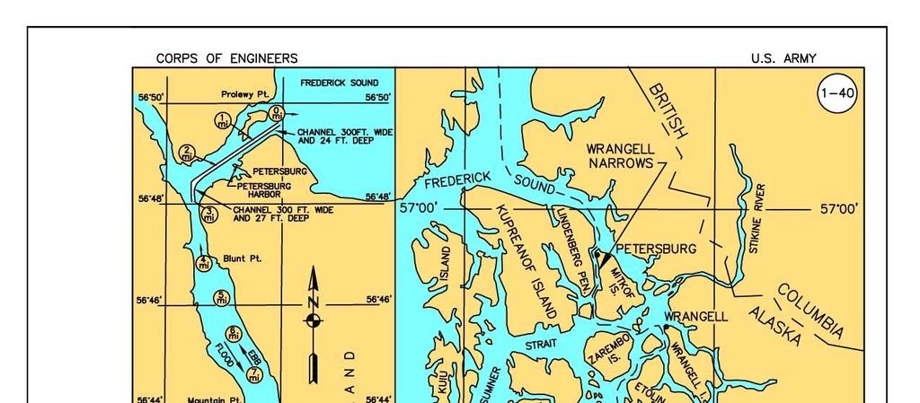
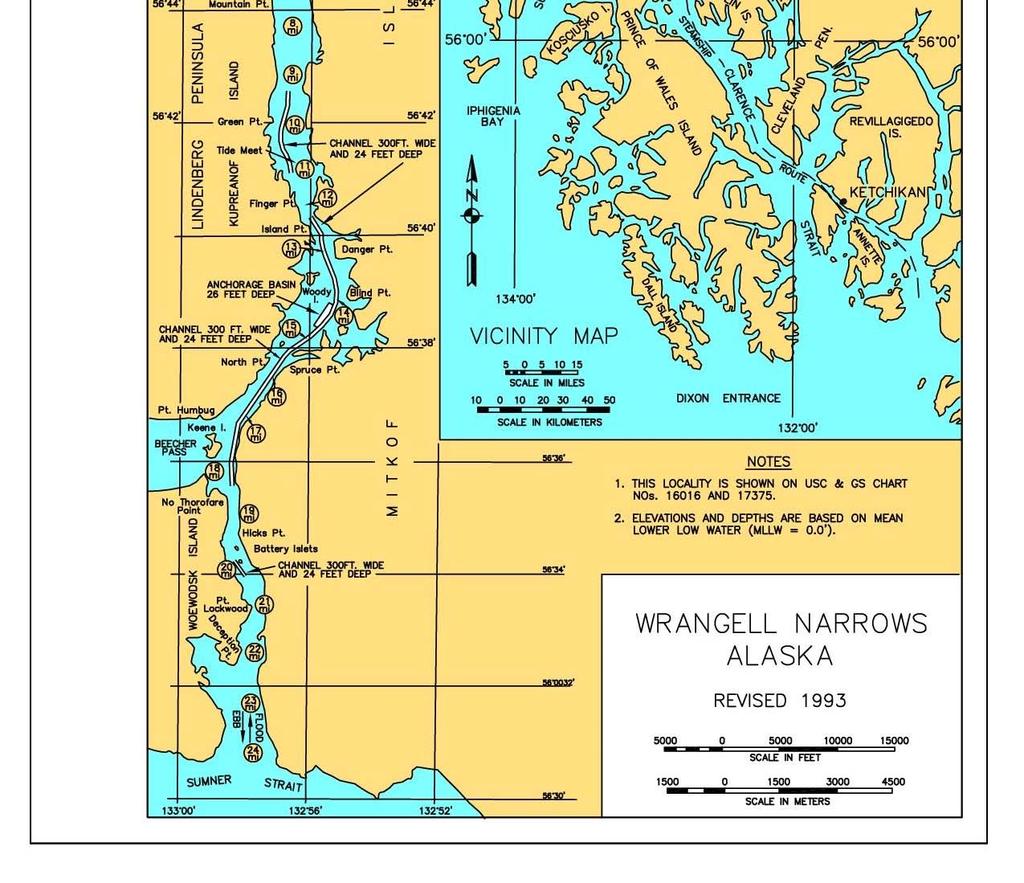
3 1-52 WRANGELL NARROWS, ALASKA (CWIS NOS & 65015) Condition of Improvement 30 September 2008 AUTHORIZATION: (1) Rivers and Harbors Act, 3 March 1925 (House Doc. 179, 67th Congress, 2nd Session) as adopted, provides for a channel 200 feet wide at 21 feet below MLLW with increased depth in rock at shoal 1 (in the vicinity of Mile 0.0) and 27 feet below MLLW at shoal 2 (in the vicinity of Mile 2.5, Turn Point). (2) Rivers and Harbors Act, 30 August 1935 (House Doc. 647, 71st Congress, 3rd Session) as adopted, provides for enlargement of the channel at shoal 1 to 300 feet wide by 24 feet deep, for the easing of alignment curves, and for the removal of rock pinnacles. (3) Rivers and Harbors Act, 2 March 1945 (House Doc. 260, 76th Congress, 1st Session) as adopted, provides for a channel 300 feet wide at 24 feet below MLLW, with improvement of the existing alignment, and an anchorage basin 200 yards wide by 500 yards long at a depth of 26 feet below MLLW in the vicinity of mile 14. EXISTING PROJECT: LENGTH DEPTH WIDTH Channel (total section) miles -24 ft 300 ft Turn Point channel section ft -27 ft Varies Anchorage Basin ft -26 ft 600 ft (max) (max) PROJECT USAGE: The major portion of all commerce through Southeast Alaska passes through this channel which provides a safe alternative to 90 miles of hazardous seas. The anchorage basin in the vicinity of Anchor Point (Mile 14) is used as a holding area when waiting for fog to clear. PROGRESS OF WORK: The original project is completed to the dimensions specified Work to increase the channel to 300 feet wide by 24 feet deep with improved alignment is completed in June Construction begins on the anchorage basin in the vicinity of mile 14 in April and is completed in May Maintenance dredging is conducted throughout the channel in September and October with 56,890 cubic yards removed by contract The Turn Point vicinity near Petersburg is dredged in May and June with 36,900 cubic yards reportedly removed. A hydro-survey of the entire channel in July indicates that project depth is available throughout Two large boulders are removed from the channel in the vicinity of Green Rock (mile ) The Corps' owned dredge YAQUINA conducts dredging operations throughout the narrows' shoals A condition survey is conducted near Burnt Island (mile 17) after a tanker ran aground; project depth is available within the Federal limits The most recent survey of the channel from miles 9 to 11 (Green Pt. to Finger Pt.) is performed in August The channel is surveyed in the vicinity of the Battery Islets (mile 20) in February. Continues on page 1-52a 1-52
4 WRANGELL NARROWS, ALASKA (continued) 30 September a A survey of the channel from Frederick Sound through Turn Point (mile ) is conducted in May A condition survey is conducted from mile 12.2 to 18.4 in April. Sampling and testing is completed for the entire project Dredging is conducted under contract for two areas from Frederick Sound through Turn Point with a payable quantity of 41,000 cubic yards removed from the project Three stretches of the narrows are surveyed with multi-beam equipment in the vicinity of miles 13, 15, and A multi-beam survey is conducted in the vicinity of mile 9.5 and from mile 12.2 to 18.4 (buoy 42 to buoy 8) to provide full swath coverage of the bottom A single beam survey is performed from mile 0.0 at Frederick Sound through Turn Point to mile Maintenance dredging begins at selected locations from Mile 12.2 to 18.4 and at the Battery Islets near Mile Maintenance dredging is completed in March. The total payable quantity removed is 33,939 cubic yards Mile 0.0 at Frederick Sound through Mile 3.0 at Turn Point, and Mile 20 are surveyed in March. Thirty day tide stations are set up near Miles 12, 15, 18, and 20 to establish new tidal bench marks for this portion of the narrows A project condition survey was conducted in April-May. COST TO DATE: New Work Maintenance Total $ 3,562,343* $ 8,975,312 $ 12,537,655 * Includes $136,737 from Public Works Funds. RANGE OF TIDE: Mean Range Diurnal Range Extreme Range Petersburg 13.8' 15.7' 25.0' Finger Pt. 14.2' 16.7' 25.0' Pt. Lockwood 13.1' 15.7' 24.0' CONTROLLING DEPTH: In the Turn Point Channel Section, a depth of feet MLLW controls. For miles 0-3 within the -24 feet project depth, feet MLLW controls near obstruction 11.A controlling depth of 21.2' MLLW is reported near Mile 1.5 (from Frederick Sound) in March 2003, and -23.5' MLLW was found near Mile 9.5 in November 1997; a depth of controls from buoy 42 to buoy 8 along the centerline at Buoy 36 near Mile 13.0, April A controlling depth of -21.7' was found at Mile 20 (Battery Islets) in March About mile 0.75 controlling depth is and around mile 16 the controlling depth is recorded in the 2008 survey. Continues on page 1-52b 1-52a
5 WRANGELL NARROWS, ALASKA (continued) 30 September 2008 MAINTENANCE DREDGING SUPPLEMENT: 1-52b A. General 1. Maintenance dredging of shoals through the entire channel was conducted in 1971 and The Turn Point vicinity required additional dredging in 1979 and Hydro-survey of some portion of the channel is conducted almost annually as per the schedule or because of vessel groundings. Isolated boulders have been known to obstruct the channel. 2. The Turn Point vicinity near Petersburg has historically experienced the greatest shoaling. Other narrow portions of the channel (see map) are also subject to shoaling along the limits. 3. The dredging window runs from 1 July through 31 March; blasting has been permitted from 16 September through 31 March 4. The YAQUINA, a large trailing arm suction hopper dredge, was used to dredge the entire project in More localized dredging is usually carried out with a clamshell and barge. B. Sampling & Testing 1. Sixteen (16) sites were sampled over the length of the narrows, March Sediment classifications (as per ASTM D-2487) ranged from silty sand (SM) to poorly graded gravel (GP) with various combinations of silt, sand, and gravel in between. 2. Chemical analysis was performed using (6) test methods as outlined with results below: Method 8260 Volatile Organic Compounds ND or below management levels Method 8270 Semivolatile Organics ND or below management levels Method 8080 Pesticides and PCB s none detected (ND) Series s (8) RCRA Metals (4) of (8) detected, all well below management levels Method Total Organic Carbon % Method Percent Solids % C. Disposal 1. Material is transported by barge or hopper to a deep water site in Frederick Sound or Sumner Strait for disposal. 2. The Frederick Sound disposal site is described by the following geographic corner coordinates: (1) N W, (2) N W, (3) N W, and (4) E W. The site encompasses a rectangular area 1,339 by 2,398 feet. A site needs to be selected for Sumner Strait when dredging again becomes necessary at this end of the narrows. 3. Deep water disposal, outside the confines of the narrows, has been the option of choice for dredge spoils. Continues on page 1-52c 1-52b
6 WRANGELL NARROWS, ALASKA (continued) 30 September c D. Environmental Permits and Reports 1. Environmental Assessments were completed by the Corps for the Turn Point vicinity in October 1978 and March A Final Chemical Data Report was prepared by the Corps in June 1994 for the entire project. 2. The following permits or authorizations are listed by agency below: Agency Name Date of Issue Date of Expiration ADGC 31 May 95 N/A ADF&G 31 May 95 N/A ADEC 8 May 95 N/A USFWS 3 Apr 95 N/A Future dredging endeavors will require full agency participation. 3. Water Quality: Six physical parameters were measured at four sites through the water column, March 1994; temperature, ph, dissolved oxygen, conductivity, salinity, and turbidity. Additionally, field measurements were taken at two other sites but without recording salinity and turbidity. No chemical analysis was conducted. 1-52c

7 WRANGELL NARROWS, ALASKA

8 WRANGELL NARROWS, ALASKA

9 WRANGELL NARROWS, ALASKA
1-6 CORDOVA HARBOR, ALASKA (CWIS NO ) (CWIS NO ) (CWIS NO ) Condition of Improvement 30 September 2011
 (CWIS NO ) (CWIS NO ) Condition of Improvement 30 September 2011") CORDOVA 1-6 CORDOVA HARBOR, ALASKA (CWIS NO. 87136) (CWIS NO. 87186) (CWIS NO. 87711) Condition of Improvement 30 September 2011 AUTHORIZATION: Rivers and Harbors Act, 30 August 1935 (R & H Committee
CORDOVA 1-6 CORDOVA HARBOR, ALASKA (CWIS NO. 87136) (CWIS NO. 87186) (CWIS NO. 87711) Condition of Improvement 30 September 2011 AUTHORIZATION: Rivers and Harbors Act, 30 August 1935 (R & H Committee
Cook Inlet Navigation Channel
 Cook Inlet Navigation Channel Cook Inlet Navigation Channel Page 2 of 9 Condition of Improvements 31 December 2017 Cook Inlet Navigation Channel, Alaska (CWIS No. 010324, 010534) Authorization (1) Water
Condition of Improvements 30 December 2014 Cordova Harbor, Alaska (CWIS No , , )
") Cordova Harbor Condition of Improvements 30 December 2014 Cordova Harbor, Alaska (CWIS No. 087136, 087186, 087711) Authorization Rivers and Harbors Act, 30 August 1935 (R & H Committee Doc. 33, 73rd Congress,
Cordova Harbor Condition of Improvements 30 December 2014 Cordova Harbor, Alaska (CWIS No. 087136, 087186, 087711) Authorization Rivers and Harbors Act, 30 August 1935 (R & H Committee Doc. 33, 73rd Congress,
Public Notice. Navigation Section Notice Date: May 23, 2018 PO Box 3755 Expiration Date: June 21, 2018
 Public Notice Navigation Section Notice Date: May 23, 2018 PO Box 3755 Expiration Date: June 21, 2018 Seattle, WA 98124-3755 Reference: PMP-18-15 ATTN: John Pell (OD-TS-NS) or Joanne Gardiner (PMP-E) US
FORUM ON USE OF CAD CELLS IN NEWARK BAY VS. OFF-SITE DISPOSAL
 FORUM ON USE OF CAD CELLS IN NEWARK BAY VS. OFF-SITE DISPOSAL July 22, 2014 New Jersey Institute of Technology 7/26/2014 Diamond Alkali Superfund Site Contaminated with dioxins, PCBs, pesticides, metals,
PROPOSED PLAN FOR CLEANING UP THE LOWER 8 MILES OF THE LOWER PASSAIC RIVER
 PROPOSED PLAN FOR CLEANING UP THE LOWER 8 MILES OF THE LOWER PASSAIC RIVER June 23, 2014 Belleville, New Jersey 6/16/2014 New York- New Jersey Harbor Estuary Lower Passaic River Diamond Alkali Superfund
Detailed Project Description
 Detailed Project Description The current sedimentation patterns in the river have resulted in the expansion and downstream migration of the gravel bar. Because the portion of the bar that must be removed
Public Notice U.S. ARMY CORPS OF ENGINEERS, GALVESTON DISTRICT
 Public Notice U.S. Army Corps Permit Application No: SWG-2013-00147 Of Engineers Date Issued: 23 May 2017 Galveston District Comments Due: 23 June 2017 U.S. ARMY CORPS OF ENGINEERS, GALVESTON DISTRICT
ENVIRONMENTAL RESTORATION IN COASTAL MISSISSIPPI: MARSH RE-ESTABLISHMENT PROJECT HARRISON AND JACKSON COUNTIES, MISSISSIPPI
 SECTION 404(b)(1) EVALUATION REPORT FOR THE SECTION 204 ECOSYSTEM RESTORATION PROJECT IN CONNECTION WITH CONSTRUCTION, OPERATION, OR MAINTENANCE DREDGING OF A FEDERALLY AUTHORIZED PROJECT ENVIRONMENTAL
SECTION 404(b)(1) EVALUATION REPORT FOR THE FOR THE OPERATIONS AND MAINTENANCE OF THE FEDERALLY AUTHORIZED BILOXI HARBOR NAVIGATION PROJECT OTT BAYOU
(1) EVALUATION REPORT FOR THE FOR THE OPERATIONS AND MAINTENANCE OF THE FEDERALLY AUTHORIZED BILOXI HARBOR NAVIGATION PROJECT OTT BAYOU") SECTION 404(b)(1) EVALUATION REPORT FOR THE FOR THE OPERATIONS AND MAINTENANCE OF THE FEDERALLY AUTHORIZED BILOXI HARBOR NAVIGATION PROJECT OTT BAYOU HARRISON COUNTY, MISSISSIPPI I. PROJECT DESCRIPTION:
SECTION 404(b)(1) EVALUATION REPORT FOR THE FOR THE OPERATIONS AND MAINTENANCE OF THE FEDERALLY AUTHORIZED BILOXI HARBOR NAVIGATION PROJECT OTT BAYOU HARRISON COUNTY, MISSISSIPPI I. PROJECT DESCRIPTION:
EAST WATERWAY HARBOR ISLAND SUPERFUND SITE CLEANUP CLEANING UP THE ENVIRONMENT, WHILE IMPROVING COMMERCE FOR THE PORT OF SEATTLE
 EAST WATERWAY HARBOR ISLAND SUPERFUND SITE CLEANUP CLEANING UP THE ENVIRONMENT, WHILE IMPROVING COMMERCE FOR THE PORT OF SEATTLE Ravi Sanga 1 ABSTRACT In 2003, the EPA entered into an agreed order with
SANDY HOOK CHANNEL, NEW YORK HARBOR FEDERAL NAVIGATION PROJECT MAINTENANCE DREDGING
 Public Notice In replying refer to: Public Notice No. Sandy Hook Channel, NY Harbor FY17 Published: 14 February 2017 Expires: 14 March 2017 New York District 26 Federal Plaza New York, N.Y. 10278 ATTN:
Environmental Assessment Appendix H: Section 404(b)(1) Guidelines Evaluation. U.S. Army Corps of Engineers New York District
(1) Guidelines Evaluation. U.S. Army Corps of Engineers New York District") Environmental Assessment Appendix H: Section 404(b)(1) Guidelines Evaluation U.S. Army Corps of Engineers New York District January 2004 APPENDIX H SECTION 404(b)(1) GUIDELINES EVALUATION SECTION 404(b)(1)
Environmental Assessment Appendix H: Section 404(b)(1) Guidelines Evaluation U.S. Army Corps of Engineers New York District January 2004 APPENDIX H SECTION 404(b)(1) GUIDELINES EVALUATION SECTION 404(b)(1)
APPENDIX A SECTION 404(B)(1) EVALUATION TYBEE ISLAND, GEORGIA SHORE PROTECTION PROJECT RENOURISHMENT
(1) EVALUATION TYBEE ISLAND, GEORGIA SHORE PROTECTION PROJECT RENOURISHMENT") APPENDIX A SECTION 404(B)(1) EVALUATION TYBEE ISLAND, GEORGIA SHORE PROTECTION PROJECT 2014-2015 RENOURISHMENT U.S. ARMY CORPS OF ENGINEERS SAVANNAH DISTRICT JUNE 2014 This page intentionally blank. SECTION
APPENDIX A SECTION 404(B)(1) EVALUATION TYBEE ISLAND, GEORGIA SHORE PROTECTION PROJECT 2014-2015 RENOURISHMENT U.S. ARMY CORPS OF ENGINEERS SAVANNAH DISTRICT JUNE 2014 This page intentionally blank. SECTION
U.S. Army Corps of Engineers Jacksonville District Sediment Quality Control/Quality Assurance Plan For Maintenance Dredging with Beach Placement
 U.S. Army Corps of Engineers Jacksonville District Sediment Quality Control/Quality Assurance Plan For Maintenance Dredging with Beach Placement Name of Project: Maintenance Dredging AIWW Vicinity Jupiter
PUBLIC NOTICE NO. FP13-AB03-05 August 30, 2013 CESAM-PD-EC JOINT PUBLIC NOTICE
 DEPARTMENT OF THE ARMY MOBILE DISTRICT, CORPS OF ENGINEERS P.O. BOX 2288 MOBILE, ALABAMA 36628-0001 REPLY TO ATTENTION OF: JOINT PUBLIC NOTICE U. S. ARMY CORPS OF ENGINEERS, MOBILE DISTRICT AND FLORIDA
Dredging Project Update
 Dredging Project Update Fall 2009 Hadley SARATOGA WARREN Glens Falls Thompson Is. Dam Fort Miller Dam Northumberland Dam Schuylerville WASHINGTON Falls Bakers Falls Fort Edward Section 1 Section 2 Upper
Sediment Characterization Report
 Sediment Characterization Report Old Douglas Replacement June 2007 Revised November 2007 Jennifer Lundberg, CEP, MES Senior Environmental Scientist Prepared for: Page i of i Table of Contents Introduction...
GREAT KILLS HARBOR, STATEN ISLAND, NEW YORK FEDERAL NAVIGATION PROJECT MAINTENANCE DREDGING
 Public Notice In replying refer to: Public Notice No. GREAT KILLS HARBOR FY13 Published: April 30, 2013, Expires: May 30, 2013 New York District 26 Federal Plaza New York, N.Y. 10278 ATTN: CENAN-OP-ST
New York- New Jersey Harbor Estuary. Lower Passaic River
 Lower 8 Miles of the Lower Passaic River Focused Feasibility Study November 7, 2013 New York- New Jersey Harbor Estuary Lower Passaic River 2 Diamond Alkali Superfund Site: Contaminated with dioxins, PCBs,
DOUGLAS HARBOR DREDGE MATERIAL DISPOSAL PRACTICABLE ALTERNATIVE ANALYSIS REPORT POA M3
 June 25, 2009 PND Project # 062065.01 DOUGLAS HARBOR DREDGE MATERIAL DISPOSAL PRACTICABLE ALTERNATIVE ANALYSIS REPORT POA 2000-495 - M3 This report is written to evaluate dredge material disposal alternatives
PROGRAMMATIC ESA 1 CONSULTATION Specific Project Information Form For Tideland Markers Version: May 2012
 PROGRAMMATIC ESA 1 CONSULTATION Specific Project Information Form For Tideland Markers Version: May 2012 Eligibility for Programmatic Consultation To be filled out by Corps This application: s all of the
SECTION I: BACKGROUND INFORMATION
 APPROVED JURISDICTIONAL DETERMINATION FORM U.S. Army Corps of Engineers SECTION I: BACKGROUND INFORMATION A. REPORT COMPLETION DATE FOR APPROVED JURISDICTIONAL DETERMINATION (JD): 29-Nov-2012 B. DISTRICT
Morris Cove as a Confined Aquatic
 Morris Cove as a Confined Aquatic Disposal (CAD) Cell Bridgeport Maintenance Dredging Project Public Meeting 25 October 2010 Thomas J. Fredette, PhD USACE Army Engineer Research Lab Vicksburg, MS Sediment
APPENDIX 2. Evaluation under Section 404 (b)(1) of the Clean Water Act Two Moon Bay
(1) of the Clean Water Act Two Moon Bay") APPENDIX 2 Evaluation under Section 404 (b)(1) of the Clean Water Act Two Moon Bay EVALUATION UNDER SECTION 404(b)(1) OF THE CLEAN WATER ACT FOR TWO MOON BAY DISPOSAL AREA VALDEZ, ALASKA I. PROPOSED PROJECT
APPENDIX 2 Evaluation under Section 404 (b)(1) of the Clean Water Act Two Moon Bay EVALUATION UNDER SECTION 404(b)(1) OF THE CLEAN WATER ACT FOR TWO MOON BAY DISPOSAL AREA VALDEZ, ALASKA I. PROPOSED PROJECT
30 DAY PUBLIC NOTICE MAINTENANCE DREDGING OF THE FEDERAL NAVIGATION PROJECT IN THE HOUSATONIC RIVER, STRATFORD AND MILFORD, CONNECTICUT
 I-~ I II I " I US Army Corps of Engineers New England District 66 Virginia Road Concord, MA 01742-2751 Public Notice In Reply Refer to: Jack Karalius nae-pn-nav@usace.army.mil Programs/Project Management
4. FISH PASSAGE CONCEPTS
 Feasibility Study for Restoration of Titlow Lagoon Fish Passage South Puget Sound Salmon Enhancement Group 4. FISH PASSAGE CONCEPTS Fish passage could be improved by rehabilitating the existing fish passage,
30 DAY PUBLIC NOTICE MAINTENANCE DREDGING OF THE PLYMOUTH HARBOR FEDERAL NAVIGATION PROJECT PLYMOUTH, MASSACHUSETTS
 696 Virginia Road Concord, MA 01742-2751 Public Notice In Reply Refer to: Mr. Michael Walsh nae-pn-nav@usace.army.mil Programs & Project Management Division Date: June 14, 2018 Comment Period Closes: July
NEW HAVEN HARBOR CONNECTICUT NAVIGATION IMPROVEMENT
 NEW HAVEN HARBOR CONNECTICUT NAVIGATION IMPROVEMENT 255 255 255 237 237 237 0 0 0 217 217 217 163 163 163 200 200 200 INTEGRATED FEASIBILITY STUDY AND ENVIRONMENTAL IMPACT STATEMENT 131 132 122 PUBLIC
APPENDIX E: RIVERFRONT ACCESS, DREDGING AND MARINE INFRASTRUCTURE ASSESSMENT REPORT
 APPENDIX E: RIVERFRONT ACCESS, DREDGING AND MARINE INFRASTRUCTURE ASSESSMENT REPORT This Page Intentionally Left Blank RIVERFRONT ACCESS, DREDGING, AND MARINE INFRASTRUCTURE ASSESSMENT REPORT BARLOW POINT
30 DAY PUBLIC NOTICE MAINTENANCE DREDGING OF THE FEDERAL NAVIGATION PROJECT IN THE ROYAL RIVER, YARMOUTH, MAINE
 PUBLIC NOTICE 696 Virginia Road Concord, MA 01742-2751 In Reply Refer to: Programs Project Management Division Email: nae-pn-nav@usace.army.mil Date: February 28, 2013 Comment Period Closes: April 1, 2013
Charleston Harbor Post 45 Draft Integrated Feasibility Report/Environmental Impact Statement Executive Summary
 Charleston Harbor Post 45 Draft Integrated Feasibility Report/Environmental Impact Statement i U.S. ARMY CORPS OF ENGINEERS NAVIGATION MISSION Provide safe, reliable, efficient, and environmentally sustainable
Joint Public Notice. PURPOSE: To restore navigation depths for vessels using the facility. DREDGED MATERIAL MANAGEMENT PROGRAM (DMMP):
:") US Army Corps of Engineers Seattle District Joint Public Notice Application for a Department of the Army Permit and a Washington Department of Ecology Water Quality Certification and/or Coastal Zone Management
US Army Corps of Engineers Seattle District Joint Public Notice Application for a Department of the Army Permit and a Washington Department of Ecology Water Quality Certification and/or Coastal Zone Management
DEPARTMENT OF THE ARMY US ARMY CORPS OF ENGINEERS SOUTH ATLANTIC DIVISION 60 FORSYTH STREET SW, ROOM 10M15 ATLANTA, GA
 REPLY TO ATTENTION OF DEPARTMENT OF THE ARMY US ARMY CORPS OF ENGINEERS SOUTH ATLANTIC DIVISION 60 FORSYTH STREET SW, ROOM 10M15 ATLANTA, GA 30303-8801 CESAD-RBT 20 June 2012 MEMORANDUM FOR COMMANDER,
Department of Army Permitting Process: Dredging
 Department of Army Permitting Process: Dredging Brian Bader Regulatory Project Manager Regulatory Division USACE Galveston District Dredging Your Docks Seminar - 2015 Beaumont, Texas December 2, 2015 US
Predictive Modeling and Design Solutions for Beneficial Use of Dredged Material
 Predictive Modeling and Design Solutions for Beneficial Use of Dredged Material Presented by Tom Wang, P.E., and Kathy Ketteridge, Ph.D., P.E. January 28, 2016 Overview of Presentation Introductions Examples
Characterization of Suspended Sediment Plumes at the Port of Oakland and Port of Redwood City, California
 Characterization of Suspended Sediment Plumes at the Port of Oakland and Port of Redwood City, California Douglas Clarke, Andrew Martin, Charles Dickerson, Kevin Reine & David Moore Topics Need for knockdown
Public Notice 15 DAY PUBLIC NOTICE
 US Army Corps of Engineers New England District 696 Virginia Road Concord, MA 01742-2751 Public Notice In Reply Refer to: Programs and Project Management Division Date: September 24, 2015 Comment Period
Massachusetts Port Authority Subordinated Obligations, Crane Financing and Commercial Paper Notes
 Massachusetts Port Authority Subordinated Obligations, Crane Financing and Commercial Paper Notes TEFRA Hearing April 11, 2018 1. Overview of Conley Terminal Berth 10 & Cranes and other Maritime improvements
Florida Inland Navigation District: Permitting and Construction of the M 5 Island Offloading & Crossroads Maintenance Dredging and the NA 1 Upland
 Florida Inland Navigation District: Permitting and Construction of the M 5 Island Offloading & Crossroads Maintenance Dredging and the NA 1 Upland DMMA Facility Authored by Lori Brownell, P.E. and John
PORT OF PORT TOWNSEND. Point Hudson Marina Breakwater Preliminary Design
 PORT OF PORT TOWNSEND Point Hudson Marina Breakwater Preliminary Design December 5, 2014 1 Outline Project Status (Scopes of Work, To-Do List from Conceptual Design) Existing Conditions Alternative Evaluation
Appendix C. Clean Water Act: Section 404(b)(1) Evaluation
(1) Evaluation") Appendix C Clean Water Act: Section 404(b)(1) Evaluation CLEAN WATER ACT: SECTION 404 (b) (1) EVALUATION CLEAN WATER ACT: SECTION 404 (b) (1) EVALUATION MONTAUK POINT STORM DAMAGE REDUCTION PROJECT MONTAUK
Appendix C Clean Water Act: Section 404(b)(1) Evaluation CLEAN WATER ACT: SECTION 404 (b) (1) EVALUATION CLEAN WATER ACT: SECTION 404 (b) (1) EVALUATION MONTAUK POINT STORM DAMAGE REDUCTION PROJECT MONTAUK
Appendix D 404(b) Analysis
 Analysis") Appendix D 404(b) Analysis Appendix D - Evaluation of Section 404(b)(1) Guidelines I. Project Description A. Location: Delaware Bay and bayshore communities (Pickering Beach, Kitts Hummock, Bowers Beach,
Appendix D 404(b) Analysis Appendix D - Evaluation of Section 404(b)(1) Guidelines I. Project Description A. Location: Delaware Bay and bayshore communities (Pickering Beach, Kitts Hummock, Bowers Beach,
30 DAY PUBLIC NOTICE MAINTENANCE OF THE NEW HAVEN HARBOR FEDERAL NAVIGATION PROJECT NEW HAVEN, CONNECTICUT
 696 Virginia Road Concord MA 01742-2751 Public Notice In Reply Refer to: Craig Martin nae-pn-nav@usace.army.mil Programs/Project Management Division Date: January 29 2013 Comment Period Closes: February
Encinitas-Solana Beach Coastal Storm Damage Reduction Project. San Diego County, California. Appendix D. 404(b)(1) Evaluation
(1) Evaluation") 1 2 3 4 5 6 7 8 9 10 Encinitas-Solana Beach Coastal Storm Damage Reduction Project San Diego County, California Appendix D 404(b)(1) Evaluation 11 12 13 14 15 16 17 U.S. Army Corps of Engineers Los Angeles
1 2 3 4 5 6 7 8 9 10 Encinitas-Solana Beach Coastal Storm Damage Reduction Project San Diego County, California Appendix D 404(b)(1) Evaluation 11 12 13 14 15 16 17 U.S. Army Corps of Engineers Los Angeles
Bethel Bank Stabilization
 Bethel Bank Stabilization Condition of Improvements 30 December 2014 Bethel Bank Stabilization, Alaska (CWIS No. 012314, 075440) Authorization Public Law 99-662, under Section 202, 17 November 1986, as
DRAFT SECTION 404(b)(1) EVALUATION REPORT CONTINUED MAINTENANCE DREDGING OF THE FEDERALLY AUTHORIZED EASTPOINT NAVIGATION PROJECT
(1) EVALUATION REPORT CONTINUED MAINTENANCE DREDGING OF THE FEDERALLY AUTHORIZED EASTPOINT NAVIGATION PROJECT") DRAFT SECTION 404(b)(1) EVALUATION REPORT CONTINUED MAINTENANCE DREDGING OF THE FEDERALLY AUTHORIZED EASTPOINT NAVIGATION PROJECT FRANKLIN COUNTY, FLORIDA I. PROJECT DESCRIPTION: A. Location: The federally
DRAFT SECTION 404(b)(1) EVALUATION REPORT CONTINUED MAINTENANCE DREDGING OF THE FEDERALLY AUTHORIZED EASTPOINT NAVIGATION PROJECT FRANKLIN COUNTY, FLORIDA I. PROJECT DESCRIPTION: A. Location: The federally
Section 404(b)(1) Evaluation
(1) Evaluation") Appendix B: Section 404(b)(1) Evaluation Lower Pool 2 Channel Management Study: Boulanger Bend to Lock and Dam No. 2 I. Project Description A. Location The proposed fill activities would occur between
Appendix B: Section 404(b)(1) Evaluation Lower Pool 2 Channel Management Study: Boulanger Bend to Lock and Dam No. 2 I. Project Description A. Location The proposed fill activities would occur between
Issuing Office: CELRB-PM-EA Published: 22 FEB 2019 Notice No: SANDUSKY-19 Expires: 25 MAR 2019
 Public Notice Issuing Office: CELRB-PM-EA Published: 22 FEB 2019 Notice No: SANDUSKY-19 Expires: 25 MAR 2019 OPERATION AND MAINTENANCE DREDGING AND DREDGED SEDIMENT PLACEMENT SANDUSKY HARBOR ERIE COUNTY,
January US Army Corps of Engineers Savannah District South Atlantic Division
 ENVIRONMENTAL IMPACT STATEMENT APPENDIX T: US Fish and Wildlife Service Savannah National Wildlife Refuge Compatibility Determination SAVANNAH HARBOR EXPANSION PROJECT Chatham County, Georgia and Jasper
Environmental Restoration in Harbor and Port Areas
 Environmental Restoration in Harbor and Port Areas John Scandura, Branch Chief California Dept. of Toxic Substances Control Brownfields & Environmental Restoration Program Cypress, California California
New Haven Harbor, Connecticut Navigation Improvement Feasibility Study and Environmental Impact Statement
 New Haven Harbor, Connecticut Navigation Improvement Feasibility Study and Environmental Impact Statement Public Informational Meeting NEPA Scoping 24 January 2017 Planning Division New England District
Department of Army Permitting Process: Dredging
 Department of Army Permitting Process: Dredging Elizabeth Shelton Regulatory Specialist Regulatory Division USACE Galveston District Dredging Your Docks Seminar - 2015 Corpus Christi, Texas October 8,
PROGRAMMATIC ESA 1 CONSULTATION Specific Project Information Form For Minor Bank Stabilization Repair Activities Version: May 2012
 PROGRAMMATIC ESA 1 CONSULTATION Specific Project Information Form For Minor Bank Stabilization Repair Activities Version: May 2012 Eligibility for Programmatic Consultation To be filled out by Corps This
APPENDIX H. EVALUATION UNDER SECTION 404(b)(1) CLEAN WATER ACT. Alaska Deep-Draft Arctic Port System Study
(1) CLEAN WATER ACT. Alaska Deep-Draft Arctic Port System Study") APPENDIX H EVALUATION UNDER SECTION 404(b)(1) CLEAN WATER ACT Study The purpose of the Section 404(b)(1) Guidelines is to restore and maintain the chemical, physical, and biological integrity of the waters
APPENDIX H EVALUATION UNDER SECTION 404(b)(1) CLEAN WATER ACT Study The purpose of the Section 404(b)(1) Guidelines is to restore and maintain the chemical, physical, and biological integrity of the waters
SEPTEMBER 18, 2018 SUBMITTED TO: STATE OF NEW YORK DEPARTMENT OF STATE COASTAL ZONE MANAGEMENT PROGRAM
 COASTAL ZONE MANAGEMENT CONSISTENCY DETERMINATION FOR THE IMPROVEMENT DREDGING OF THE NEW HAVEN HARBOR FEDERAL NAVIGATION PROJECT (NEW HAVEN, CONNECTICUT) SEPTEMBER 18, 2018 SUBMITTED TO: STATE OF NEW
NEW YORK / NEW JERSEY HARBOR DEEPENING PROJECT
 NEW YORK / NEW JERSEY HARBOR DEEPENING PROJECT Using Synergy to Successfully Execute A Mega Water Resource Project Joseph J. Seebode Deputy District Engineer U.S. Army Corps of Engineers New York District
PROFESSIONAL SERVICES DESCRIPTION FOR THE POSITION OF: Paulsboro Marine Terminal Sediment Sampling Survey of Mitigation Site
 PROFESSIONAL SERVICES DESCRIPTION FOR THE POSITION OF: Paulsboro Marine Terminal Sediment Sampling Survey of Mitigation Site SUBMISSION DEADLINE: July 9, 2010 at 11:00 A.M. FAIR AND OPEN PUBLIC SOLICITATION
F. Impact on the Receiving Environment
 F. Impact on the Receiving Environment Dredging is a necessity for the port to remain commercially active. However, over the past two decades the Port of Waterford has acquired numerous reports and investigations
Postal Code V7M 1A5 Fax
 Contact financially sensitive in formation which you do not want provided to third parties. public through the Access to Information Act. Please advise PMV of any commercially or municipalities, First
Economic Analysis. Appendix C: Lower Pool 2 Channel Management Study: Boulanger Bend to Lock and Dam No. 2
 Appendix C: Economic Analysis Lower Pool 2 Channel Management Study: Boulanger Bend to Lock and Dam No. 2 Pool 2: Boulanger Bend to Lock and Dam 2 C-1 Economic Analysis Introduction This analysis evaluates
APPLICANT: Attention: Mr. Brian Anderson The Boeing Company P.O. Box 3707, MC 2R-96 Seattle, Washington Telephone: (425) AGENT:
 AGENT:") US Army Corps of Engineers Seattle District Joint Public Notice Application for a Department of the Army Permit and a Washington Department of Ecology Water Quality Certification and/or Coastal Zone Management
US Army Corps of Engineers Seattle District Joint Public Notice Application for a Department of the Army Permit and a Washington Department of Ecology Water Quality Certification and/or Coastal Zone Management
404(b)(1) EVALUATION
(1) EVALUATION") 404(b)(1) EVALUATION SECTION 404(b)(1) EVALUATION DETAILED PROJECT REPORT AND ENVIRONMENTAL ASSESSMENT POMEROY SECTION 14 EMERGENCY STREAMBANK PROTECTION PROJECT POMEROY, OH I. INTRODUCTION As required
404(b)(1) EVALUATION SECTION 404(b)(1) EVALUATION DETAILED PROJECT REPORT AND ENVIRONMENTAL ASSESSMENT POMEROY SECTION 14 EMERGENCY STREAMBANK PROTECTION PROJECT POMEROY, OH I. INTRODUCTION As required
Kurnell Wharf Infrastructure Upgrade
 Kurnell Wharf Infrastructure Upgrade Sediment and Water Quality Monitoring Program CALTEX REFINERIES (NSW) PTY LTD September 2013 Page 1 1 INTRODUCTION Caltex Refineries (NSW) Pty Ltd (Caltex) proposes
Dredging and Dredged Material Disposal Overview
 Dredging and Dredged Material Disposal Overview Tim Welp Timothy.L.Welp@usace.army.mil 601.634.2083 The process of dredging consists of the following stages: - Excavation (loosening or dislodging) of the
Buffalo River, New York Great Lakes Restoration Initiative (GLRI) Dredging
 Dredging") Buffalo River, New York Great Lakes Restoration Initiative (GLRI) Dredging Partners: U.S. EPA New York State DEC Buffalo Niagara Riverkeeper U.S. Army Corps of Engineers Presented by: Scott Cieniawski
Buffalo River, New York Great Lakes Restoration Initiative (GLRI) Dredging Partners: U.S. EPA New York State DEC Buffalo Niagara Riverkeeper U.S. Army Corps of Engineers Presented by: Scott Cieniawski
Distribution Restriction Statement Approved for public release; distribution is unlimited.
 CECW-EH-D Regulation No. 1110-2-1404 Department of the Army U.S. Army Corps of Engineers Washington, DC 20314-1000 Engineering and Design HYDRAULIC DESIGN OF DEEP-DRAFT NAVIGATION PROJECTS Distribution
SIDA/Hilton Head Dredging And Open Water Placement Monitoring Plan
 Prepared for: GEL Engineering, LLC Charleston, SC Prepared by: Moffatt & Nichol September 4, 2012 TABLE OF CONTENTS 1. PROJECT DESCRIPTION AND LOCATION... 1 2. PURPOSE... 9 3. DREDGE MATERIAL AND WATER
A World of Solutions
 Project Goals Engineering, Economics, & Environmental Principles Minimization of execution risks Construction industry s highest standards Cost savings vs. conventional methods Consistency with Master
WA Department of Ecology SEA Program Post Office Box Olympia, WA Telephone: (360) ATTN: Federal Permit Coordinator
 ATTN: Federal Permit Coordinator") US Army Corps of Engineers Seattle District Joint Public Notice Application for a Department of the Army Permit and a Washington Department of Ecology Water Quality Certification and/or Coastal Zone Management
US Army Corps of Engineers Seattle District Joint Public Notice Application for a Department of the Army Permit and a Washington Department of Ecology Water Quality Certification and/or Coastal Zone Management
Prepared for the WEDA Midwest Chapter Meeting April Cincinnati, OH
 Indiana Harbor and Canal (IHC) Environmental Maintenance Dredging Prepared for the WEDA Midwest Chapter Meeting April 2014 - Cincinnati, OH IHC Facility Operations & Dredging Contract was awarded on 30
Public Notice of Application for Permit
 US Army Corps of Engineers Alaska District Regulatory Division (1145) CEPOA-RD Post Office Box 6898 JBER, Alaska 99506-0898 Public Notice of Application for Permit PUBLIC NOTICE DATE: January 15, 2014
Information for File # RMM
 Information for File # 20-084-R Applicant: Mr. Paul Nelson Corps Contact: Ryan Malterud Address: 80 Fifth Street East, St. Paul, Minnesota 550 E-Mail: Ryan.M.Malterud@usace.army.mil Phone: (5) 290-528
Milwaukee Harbor, Wisconsin
 Phase II Report Dredged Material Management Plan Study January 2008 Milwaukee Harbor, Wisconsin Detroit District EXECUTIVE SUMMARY The Milwaukee Harbor long-term disposal study was initiated in 1993 under
Draft Environmental Assessment and Clean Water Act, Section 404 Public Interest Review Grays Harbor and Chehalis River Federal Navigation Channel
 Draft Environmental Assessment and Clean Water Act, Section 404 Public Interest Review Grays Harbor and Chehalis River Federal Navigation Channel Maintenance Dredging and Placement 2018-2033 Grays Harbor
The release of the Final Environmental Impact Statement (FEIS) for the Bogue
 for the Bogue") This document is scheduled to be published in the Federal Register on 03/05/2018 and available online at https://federalregister.gov/d/2018-04408, and on FDsys.gov BILLING CODE: 3720-58 DEPARTMENT OF DEFENSE
This document is scheduled to be published in the Federal Register on 03/05/2018 and available online at https://federalregister.gov/d/2018-04408, and on FDsys.gov BILLING CODE: 3720-58 DEPARTMENT OF DEFENSE
Appendix C Geotechnical Soil Testing Data
 Appendix C Geotechnical Soil Testing Data rjmmmrorr Table C-1 Laboratory Soil Testing Results Groundwater Assessment Report UMore Mining Area Dakota County, Minnesota Sample Particle Size Particle Size
APPENDIX C DESIGN & ENGINEERING
 APPENDIX C DESIGN & ENGINEERING Study Authority. This study is authorized under Section 204 of the Water Resources Development Act of 1992, as amended. Study Description. This appendix presents the results
Project Review Application Form
 Project Review Application Form Information supplied in this application may be made public during consultation with adjacent municipalities, First Nations groups and other interested parties, as well
Public Notice 30 DAY PUBLIC NOTICE
 US Army Corps of Engineers New England District 696 Virginia Road Concord MA 01742-2751 Public Notice In Reply Refer to: Mike Walsh nae-pn-nav@usacearmymil Programs/Project Management Division Date: June
Cleveland Harbor Open Lake Placement
 Cleveland Harbor Open Lake Placement The U.S. Army Corps of Engineers, Buffalo District s Environmental Assessment / Finding of No Significant Impact Open Lake Placement of Material Dredged from Cleveland
SUPPLEMENTAL ENVIRONMENTAL ASSESSMENT AND FINDING OF NO SIGNIFICANT IMPACT. Annual Maintenance Dredging Nome Harbor, Alaska
 SUPPLEMENTAL ENVIRONMENTAL ASSESSMENT AND FINDING OF NO SIGNIFICANT IMPACT Annual Maintenance Dredging Nome Harbor, Alaska September 2017 FINDING OF NO SIGNIFICANT IMPACT Annual Maintenance Dredging Nome
DRAFT ENVIRONMENTAL ASSESSMENT AND SECTION 404(b)(1) EVALUATION
(1) EVALUATION") ENVIRONMENTAL ASSESSMENT AND SECTION 404(b)(1) EVALUATION MODIFICATION TO MOBILE HARBOR OPERATIONS AND MAINTENANCE ADDITION OF OPEN BAY THIN-LAYER DISPOSAL OPTION MOBILE COUNTY, ALABAMA A FEDERALLY AUTHORIZED
ENVIRONMENTAL ASSESSMENT AND SECTION 404(b)(1) EVALUATION MODIFICATION TO MOBILE HARBOR OPERATIONS AND MAINTENANCE ADDITION OF OPEN BAY THIN-LAYER DISPOSAL OPTION MOBILE COUNTY, ALABAMA A FEDERALLY AUTHORIZED
Great Chebeague Island Chebeague Island, Maine
 Initial Appraisal of Federal Interest For Continuing Authority Feasibility Investigation Section 107 Navigation Improvement Study Great Chebeague Island Chebeague Island, Maine US ARMY CORPS OF ENGINEERS
Appendix D 404(b) Analysis
 Analysis") Appendix D 404(b) Analysis Appendix D - Evaluation of Section 404(b)(1) Guidelines I. Project Description A. Location: Delaware Bay and New Jersey bayshore communities (Gandys Beach, Fortescue and Villas)
Appendix D 404(b) Analysis Appendix D - Evaluation of Section 404(b)(1) Guidelines I. Project Description A. Location: Delaware Bay and New Jersey bayshore communities (Gandys Beach, Fortescue and Villas)
Deepening/Dredging Impact on Navigational Efficiency in the Delaware River Main Channel
 Deepening/Dredging Impact on Navigational Efficiency in the Delaware River Main Channel Tayfur Altiok, Ph.D. Principal Investigator Contributing authors: Alper Almaz, Ph.D. Student Amir Ghafoori, Ph.D.
FINDING OF NO SIGNIFICANT IMPACT
 DEPARTMENT OF THE ARMY CHARLESTON DISTRICT, CORPS OF ENGINEERS 69A HAGOOD AVENUE CHARLESTON, SOUTH CAROLINA 29403-5107 FINDING OF NO SIGNIFICANT IMPACT CHARLESTON HARBOR ADDITIONAL ADVANCED MAINTENANCE
THIS IS NOT A PAID ADVERTISEMENT. Public Notice. Public Notice No.
 THIS IS NOT A PAID ADVERTISEMENT Public Notice Public Notice No. Date Wanamaker Building 100 Penn Square East Philadelphia, PA 19107-3390 ATTN: CENAP-OP-R CENAP-OP-R-2016-828-35 Application No. In Reply
APPLICANT: Decatur Head Beach Association 1327 Decatur Head Drive Decatur Island Anacortes, WA Telephone: (425)
") US Army Corps of Engineers Seattle District Joint Public Notice Application for a Department of the Army Permit and a Washington Department of Ecology Water Quality Certification and/or Coastal Zone Management
US Army Corps of Engineers Seattle District Joint Public Notice Application for a Department of the Army Permit and a Washington Department of Ecology Water Quality Certification and/or Coastal Zone Management
Design of CAD Pits in San José Lagoon, San Juan, Puerto Rico
 Second LACCEI International Latin American and Caribbean Conference for Engineering and Technology (LACCEI 2004) Challenges and Opportunities for Engineering Education, Research and Development 2-4 June
Port Gravina Quarry Operating Plan
 6/24/15 PND 151016 Port Gravina Quarry Operating Plan The Chugach Alaska Corporation (CAC) proposes to develop a quarry site within Port Gravina. In addition to the upland quarry, additional infrastructure,
Environmental Dredging Equipment and Processes. (Tab D)
") Environmental Dredging Equipment and Processes (Tab D) Norman R. Francingues, MSEE (frasang@canufly.net) Michael R. Palermo, PhD (mike@mikepalermo.com) Training Objectives Learn about dredges, types and
Environmental Dredging Equipment and Processes (Tab D) Norman R. Francingues, MSEE (frasang@canufly.net) Michael R. Palermo, PhD (mike@mikepalermo.com) Training Objectives Learn about dredges, types and
Enhancing Data Resolution to Improve Maritime Safety
 Enhancing Data Resolution to Improve Maritime Safety Pacific Northwest Waterways Association 2014 Annual Convention October 15 17 th, Vancouver, WA Jon Dasler, PE, PLS, CH Director of Marine Services,
SECTION TRENCHING
 SECTION 31 23 17 TRENCHING PART 1 GENERAL 1.1 SUMMARY A. Section Includes: 1. Excavating trenches for utilities and utility structures. 2. Bedding. 3. Backfilling and compacting to subgrade elevations.
Walk Bridge Project. Norwalk Shellfish Commission. November 1,
 Walk Bridge Project Norwalk Shellfish Commission November 1, 2018 Meeting Agenda 1. Welcome & Introductions John Hanifin, CTDOT 2. Project Update Christian Brown, HNTB Lauren DiGovanni, HNTB 3. Project
Monroe County Canal Restoration Updates Prepared by Wendy Blondin, AMEC
 Monroe County Canal Restoration Updates 7-10-13 Prepared by Wendy Blondin, AMEC Phase 1 Canal Management Master Plan (CMMP) Monroe County in association with AMEC was awarded a grant from DEP in March
Update on Lower Fox River Remediation Project, Green Bay, Wisconsin
 Update on Lower Fox River Remediation Project, Presented by P. LaRosa, PE, and D. Binkney, Anchor QEA, LLC R. Feeney, PE, and T. Blackmar, PE, Tetra Tech, Inc. G. Smith and D. Bauman, J.F. Brennan Company,
Honorable Louise Slaughter
 NY-25 Honorable Louise Slaughter New York State 114th Congress 25th Congressional District & & 2 & 1, O&M, Irondequoit Harbor 2, O&M, Rochester Harbor 3, GI, Lake Ontario Coastal Resiliency 4, IIS, Braddock
The Port of Hueneme Confined Aquatic Disposal Project: A Unique Partnership for Contaminated Sediment Management
 The Port of Hueneme Confined Aquatic Disposal Project: A Unique Partnership for Contaminated Sediment Management Presented by Jack Malone, Ph.D. Steve Cappellino May 11, 2011 Report Documentation Page
SWG Attachment A, Alternative Analysis Gulf Coast Ammonia, LLC 2/26/2018 Page 1 of 8
 SWG-21-96 2/26/218 Page 1 of 8 The four criteria are: 1. Safety and navigability of incoming and outgoing vessel traffic with consideration to neighboring operations and infrastructure. 2. Federal, State,