Appendix E. Phase I Environmental Site Assessment
|
|
|
- Julia Whitehead
- 6 years ago
- Views:
Transcription

1 Appendix E Phase I Environmental Site Assessment
2 This page intentionally left blank.
3 Phase I Environmental Site Assessment Wasilla Main Street Rehabilitation Wasilla, Alaska February 2012 Submitted To: HDR Alaska, Inc C Street, Suite 305 Anchorage, Alaska By: Shannon & Wilson, Inc Fairbanks Street, Suite 3 Anchorage, Alaska
4 EXECUTIVE SUMMARY This report documents the results of our Phase I Environmental Site Assessment (ESA) for the Wasilla Main Street Rehabilitation, Wasilla Alaska (the Project Area). The purpose of this Phase I ESA was to develop a professional opinion as to the presence of recognized environmental conditions (RECs), as defined by ASTM International (ASTM) Standard E A vicinity map, provided by HDR Alaska, Inc. (HDR), is included in Appendix A. A site plan is included as Figure 1 with inserts A and B as Figures 2 and 3, respectively. Aerial photographs of the Project Area are included as Figures 4 through 7. This Phase I ESA included a records review and visual evaluation of the Project Area grounds. Prior to the on-site evaluation, historical aerial photographs were examined to identify areas of potential concern. Records at municipal and state offices and local utilities were reviewed to determine ownership information, public utility services to the Project Area, and incidents relating to spills or chemical releases. The records review also included researching state and federal databases to determine if listed contaminated sites, underground storage tanks (USTs), or leaking USTs (LUSTs) are present in the project vicinity. Recognized Environmental Conditions A REC is the presence or likely presence of a hazardous substance or petroleum product under conditions that indicate an existing release, a past release, or a material threat of a release into structures on the Project Area or into the Project Area s ground, groundwater, or surface water. This assessment revealed no evidence of RECs in connection with the Project Area and the surrounding parcels except the following: On-Site Recognized Environmental Conditions Surface stains were observed on Talkeetna Street, located within the Project Area. This staining was observed during the aerial photograph review, most notably in the 2011 aerial photograph. Precipitation prior to the site visit limited observation of the staining while in the field; however, areas of darker soil were observed. The areas observed during the site visit included the soil in the vicinity of 450 Talkeetna Street, where heavy machinery was stored, and the portion of Talkeetna Street between East Railroad Avenue and East Susitna Avenue. The impact or source of released contaminants to the subsurface is unknown. Although ASTM contains allowances for de-minimis conditions; Alaska regulations concerning the release of oil or hazardous substances do not recognize de-minimis conditions and also require cleanup of surface stained soil. Therefore, because the surface staining would likely result in an enforcement action, it is defined as a REC by ASTM There are currently no other onsite RECs identified for the Project Area. Phase I Environmental Site Assessment, Wasilla Main Street Rehabilitation, Wasilla, Alaska i
5 Off-Site Recognized Environmental Conditions While there are no active LUST sites or open contaminated sites adjacent to the Project Area, it is noted there are two active filling stations within 90 feet. A Tesoro filling station is located adjacent to Main Street at 211 N Main Street. A Holiday filling station is located 90 feet west of Yenlo Street, at 225 N Boundary Street. These sites constitute a REC because of documented past releases of petroleum hydrocarbons and because they pose a material threat of a release of petroleum hydrocarbons that could impact the environment. It is important to note that ASTM allows the identification of a REC for a site that is in compliance with applicable laws. Historical Recognized Environmental Conditions A Historical REC is an environmental condition that may have constituted a REC in the past, but has been closed by a regulatory agency or otherwise is no longer considered to pose a material threat. On-Site Historical Recognized Environmental Conditions There are currently no on-site historical RECs identified for the Project Area. Off-Site Historical Recognized Environmental Conditions Four LUST sites are located within 175 feet of the Project Area. The parcel adjacent east of Main Street is a Tesoro located at 211 N Main Street, was added to the ADEC LUST database in 2007 when during the removal of two 10,000 gallon gasoline USTs, one 5,000 gallon diesel USTs and associated piping, DRO contamination was found in soil and groundwater. GRO contamination was also found in the groundwater above allowable cleanup levels. Contaminated soil was removed from the site. After follow up soil and groundwater sampling, site closure was approved in The Wasilla Public Safety Building #61 is adjacent to Main Street, located at Main Street and Herning Avenue. This site was added to the ADEC LUST database in 1991 after a release from a UST was confirmed. Cleanup was initiated in the same year. Site closure was approved in A & B Tool Equipment Rental is located at 450 Railroad Avenue, adjacent to KGB Road. This site was added to the ADEC LUST database on November 20, According to the database report, 67 cubic yards of contaminated soil was excavated and spread onsite. The site was closed on November 22, Phase I Environmental Site Assessment, Wasilla Main Street Rehabilitation, Wasilla, Alaska ii
6 The closest contaminated site, located adjacent to Main Street, is Wasilla City Museum at 323 North Main Street. According to the ADEC contaminated sites database, the site was added in September 1990 after diesel contamination of the soil was encountered during the removal of a heating oil tank. The site was closed by the ADEC in November 1990 after soil samples confirmed contamination levels below the ADEC cleanup levels. Other Environmental Conditions Other Environmental Conditions include known, suspected, or potential sources of hazardous substances or petroleum products that are not considered RECs due to (a) the absence of a confirmed release or other material threat, (b) insufficient information to sufficiently evaluate the condition, (c) de minimis conditions that are not expected to be subject to regulatory action or (d) exclusion from the ASTM definition of hazardous material (e.g. ACM). The following Other Environmental Conditions were identified on the Project Area: Based on aerial photographs, structures on parcels adjacent to the Project Area predate the availability of city water and sewer services. It is possible that private drinking water wells and septic tanks were and still are utilized in this area. Based on aerial photograph reviews, structures on parcels adjacent to the Project Area predate the installation of natural gas. The structures may have utilized fuel oil for heating purposes. It is unknown whether potential heating oil USTs were properly removed or abandoned in place. Releases from active and/or abandoned tanks could potentially impact the Project Area s subsurface soil and/or groundwater. Phase I Environmental Site Assessment, Wasilla Main Street Rehabilitation, Wasilla, Alaska iii
7 TABLE OF CONTENTS Page EXECUTIVE SUMMARY... I ACRONYMS AND ABBREVIATIONS... VI 1.0 INTRODUCTION Purpose Special Terms and Conditions Limitations and Exceptions User Reliance SITE AND PROJECT DESCRIPTION Location and Legal Description Site and Vicinity Characteristics Description of Improvements on the Project Area Past and Current Use of Project Area and Adjoining Parcels Previous Environmental Assessments and Reported Spills USER-PROVIDED INFORMATION Questionnaire RECORDS REVIEW Aerial Photographs Physical Setting Groundwater Characteristics Soils/Geology Historical Maps Regulatory Database Search Federal Records Sources State Records Sources Local Agency Sources SITE RECONNAISSANCE Property Grounds Evaluation Surrounding Properties Evaluation Hazardous Substances and Petroleum Products Drums Asbestos-Containing Materials Transformers Solid Waste Disposal INTERVIEWS...16 Phase I Environmental Site Assessment, Wasilla Main Street Rehabilitation, Wasilla, Alaska iv
8 6.1 Government Official OTHER ENVIRONMENTAL CONSIDERATIONS FINDINGS AND CONCLUSIONS Recognized Environmental Conditions On-Site Recognized Environmental Conditions Off-Site Recognized Environmental Conditions Historical Recognized Environmental Conditions On-Site Historical Recognized Environmental Conditions Off-Site Historical Recognized Environmental Conditions Other Environmental Conditions QUALIFICATIONS OF ENVIRONMENTAL PROFESSIONALS CLOSURE/LIMITATIONS...21 TABLES 1 Registered Underground Storage Tanks Within A 0.25-Mile Radius 2 Leaking Underground Storage Tank Sites Within A 0.5-Mile Radius 3 Contaminated Sites from ADEC Database Within A 1.0-Mile Radius FIGURES 1 Site Plan 2 Insert Map A 3 Insert Map B 4 Aerial Photograph August 10, Aerial Photograph May 12, Aerial Photograph May 9, Aerial Photograph May 24, 2011 APPENDICES A. Wasilla Main Street Rehabilitation Preliminary Area of Potential Effect Map B. Phase I Environmental Site Assessment Questionnaire C. Site Photographs D. Important Information About Your Environmental Site Assessment/Evaluation Report Phase I Environmental Site Assessment, Wasilla Main Street Rehabilitation, Wasilla, Alaska v
9 ACMs ADEC ADNR ADOT&PF ARRC ASTM CERCLIS CORRACTS DRO EPA ERNS ESA GRO HDR KGB LUST MEA NONCORRACTS NPL PCBs REC RCRA RRO ROW TSD USFWS USGS UST WELTS ACRONYMS AND ABBREVIATIONS Asbestos-Containing Materials Alaska Department of Environmental Conservation Alaska Department of Natural Resources Alaska Department of Transportation and Public Facilities Alaska Railroad Corporation ASTM International Comprehensive Environmental Response Compensation and Liability Information System TSD Facilities Subject to Corrective Action Diesel Range Organics Environmental Protection Agency Emergency Response Notification System Environmental Site Assessment Gasoline Range Organics HDR Alaska, Inc. Knik-Goose Bay Leaking Underground Storage Tank Matanuska Electric Association TSD Facilities Not Subject to Corrective Action National Priorities List Polychlorinated Biphenyls Recognized Environmental Condition Resource Conservation and Recovery Act Residual Range Organics Right-of-Way Treatment, Storage, and Disposal U.S. Fish and Wildlife Service United States Geological Survey Underground Storage Tank Well Log Tracking System Phase I Environmental Site Assessment, Wasilla Main Street Rehabilitation, Wasilla, Alaska vi
10 This page intentionally left blank.
11 PHASE I ENVIRONMENTAL SITE ASSESSMENT WASILLA MAIN STREET REHABILITATION WASILLA, ALASKA 1.0 INTRODUCTION This report documents the results of our Phase I Environmental Site Assessment (ESA) prepared for the Wasilla Main Street Rehabilitation Project, which includes a portion of the Knik Goose- Bay (KGB) Road, Main Street, Talkeetna Street, and Yenlo Street in Wasilla, Alaska (hereafter referred to as the Project Area). This Phase I ESA was limited to the Project Area as defined by a figure provided by HDR Alaska, Inc. (HDR) included in Appendix A. 1.1 Purpose The purpose of the Phase I ESA was to develop a professional opinion regarding recognized environmental conditions (RECs) as defined by ASTM International (ASTM) Standard E This term is defined by ASTM as the presence or likely presence of a hazardous substance or petroleum product under conditions that indicate an existing release, a past release, or a material threat of a release into structures on the Project Area or into the Project Area s ground, groundwater, or surface water. 1.2 Special Terms and Conditions This Phase I ESA was prepared for HDR and the Alaska Department of Transportation & Public Facilities (ADOT&PF). This work was performed in general accordance with ASTM E Authorization to proceed with the Phase I ESA was received from Mr. Mark Dalton of HDR on July 20, 2011 in the form of a signed subconsultant agreement. 1.3 Limitations and Exceptions The following elements of the Phase I ESA constitute deviations, exceptions, and/or data gaps, with respect to the standard requirements of ASTM E The Alaska Department of Environmental Conservation (ADEC) List of Contaminated Sites is assumed to be equivalent to a hazardous waste sites list and includes voluntary cleanup sites. Phase I Environmental Site Assessment, Wasilla Main Street Rehabilitation, Wasilla, Alaska
12 Tribal lists of environmental concerns were not reviewed. The tribal lists are identified as standard environmental sources in ASTM Section To our knowledge, such databases do not exist for the State of Alaska. Historical use of the Project Area is identified back to 1951, not to 1940, as required by ASTM E The oldest historical record is an aerial photograph taken August 10, While older documents regarding the historical use of the Project Area may exist, they are not from reasonably ascertainable sources. According to the City of Wasilla website, there has potentially been development in this area since around 1917 due to the town s location along a supply route to several mines in the area. All of the Standard Historical Sources listed in ASTM Section were not researched for this ESA because they were not reasonably ascertainable and likely to be useful. For example, fire insurance maps, local street directories, building department records, and property tax files were not researched. Public Ownership documents were not reviewed as part of this Phase I ASTM ESA. The current owner of the Project Area was not interviewed for this Phase I ASTM ESA. Environmental liens were not researched as part of this Phase I ASTM ESA. At the request of the users of this Phase I (HDR and ADOT&PF) clarifications were added to several sections and a revised report was issued outside of the report viability guidelines of ASTM. 1.4 User Reliance This report has been prepared for the exclusive use of HDR and ADOT&PF. The named entities above can convey this report to an affiliate, subsidiary, lender, title insurer, regulatory/city agent or current property owner(s) and their agents, but further dissemination requires prior written approval from Shannon & Wilson, Inc. The limitations of the report are further described in Section 10. Phase I Environmental Site Assessment, Wasilla Main Street Rehabilitation, Wasilla, Alaska
13 2.1 Location and Legal Description 2.0 SITE AND PROJECT DESCRIPTION The Project Area is located in a mixed residential and commercial area in downtown Wasilla, Alaska, between the Palmer-Wasilla Highway to the south and Bogard Road to the north. The Project Area will be broken down into two sections and referred to as the Main Street/KGB Corridor and the Yenlo/Talkeetna Corridor. The sections are as follows: The KGB/Main Street Corridor: This corridor includes a portion of KGB Road, beginning approximately 350 feet north of the Palmer-Wasilla Highway. The corridor continues north approximately 3,600 feet north, crossing the Alaska Railroad Corporation (ARRC) railroad tracks, where it becomes Main Street. The corridor continues along the Main Street right-of-way (ROW) onto Wasilla-Fishhook Road, ending approximately 250 feet north of the Bogard Road intersection. The width of the project area in this corridor varies; it generally spans curb-to-curb or ditch-to-ditch depending on the existing development. The Talkeetna/Yenlo Corridor: The corridor begins at KGB and continues northeast through a cleared parcel onto an undeveloped parcel until it intersects with what would be the extension of the Talkeetna Street ROW. At this point, it follows the Talkeetna Street ROW north, crossing the ARRC railroad tracks and the Parks Highway, onto the Yenlo Street ROW. The corridor continues north along the Yenlo Street ROW, turning 90 degrees to the west along Bogard Road until it ends at the Main Street intersection. The width of the project area in this corridor varies; it generally spans curb-to-curb or ditchto-ditch depending on the existing development. When no development has occurred it was assumed that the right-of-way is about 60 feet in width. A Vicinity Map showing the Project Area and surrounding area is included in Appendix A. Figures 1, 2, and 3 are site plans depicting the area surrounding the Project Area and adjacent parcels. The Project Area is located in the central portion of Section 10, Township 17 North, Range 1 West, Seward Meridian, Alaska, according to the United Stated Geological Survey (USGS) Anchorage C-7 SW and C-7 SE quadrangles. 2.2 Site and Vicinity Characteristics The Project Area is located in a mixed commercial and residential area of downtown Wasilla, as shown in Figure 1. Phase I Environmental Site Assessment, Wasilla Main Street Rehabilitation, Wasilla, Alaska
14 The KGB/Main Street Corridor includes a portion of KGB Road, a two lane paved roadway, beginning approximately 350 feet north of its intersection with the Palmer-Wasilla Highway. A parcel northeast of this intersection is actively under construction. Residential structures and miscellaneous commercial businesses, including a Weld Air facility, Batteries Plus, Totem Rentals, car wash, and a Matanuska Telephone Association building, as well as the ARRC Train Depot are located adjacent to KGB Road, as shown in Figure 2. The corridor continues north, crossing the ARRC tracks and the Parks Highway onto the Main Street, which is a paved two lane roadway. Commercial structures, restaurants, a bank, fire station, library, post office, pawn shop, and gas station are located adjacent to Main Street, as shown in Figure 3. The corridor continues for approximately 250 feet onto Wasilla Fishhook Road. A residential structure and an undeveloped parcel are located along this portion of the corridor. The Talkeetna/Yenlo Corridor includes a cleared parcel, a forest area, a drainage ditch, Talkeetna Street Yenlo Street, and a portion of Bogard Road. A portion of the corridor cuts through forested land into a drainage ditch. Talkeetna Street is an unpaved two lane road. Residential structures and a commercial structure with heavy vehicle storage are located adjacent to this roadway, see Figure 2. The corridor continues north across the ARRC tracks and Parks Highway onto Yenlo Street, which is a partially paved roadway with pavement ending approximately 400 feet south of Bogard Road. Strip malls, apartment structures, office buildings, and a grocery store are located adjacent to this roadway, as shown in Figure 3. At the end of the Yenlo Street ROW, the corridor turns 90 degrees to the west along Bogard Road until it ends at the Main Street intersection. A church, residential structure and bank are located along this portion of the corridor. 2.3 Description of Improvements on the Project Area In 1951 the KGB/Main Street Corridor and Bogard Road were utilized as two-lane unpaved roadways and the Talkeetna/Yenlo Corridor was mostly vegetated with some clearing along what is currently Talkeetna Street. Around 1966, the KGB/Main Street Corridor was widened and paved. Talkeetna Street was constructed as a two lane unpaved roadway. Yenlo Street was cleared between 1977 and 1995, when it was widened and paved as a two lane roadway. During that time, the area was used as an unpaved access road and gravel pit. A portion of the Talkeetna/Yenlo Corridor was cleared and a drainage ditch constructed. The remaining portion is undeveloped and forested. 2.4 Past and Current Use of Project Area and Adjoining Parcels An aerial photograph taken in 1951 shows the KGB/Main Street Corridor as unpaved, two lane roadways. Residential and commercial structures are located adjacent to KGB Road and Main Street. By 1977, KGB Road and Main Street had been widened and paved. The parcel east of Phase I Environmental Site Assessment, Wasilla Main Street Rehabilitation, Wasilla, Alaska
15 northeast of the KGB Road and Palmer-Wasilla Highway intersection had been cleared and was currently an active construction site. In 1951, the Talkeetna/Yenlo Corridor was mostly vegetated with some clearing along what is currently Talkeetna Street. Bogard Road was an unpaved two lane roadway. Around 1966, Talkeetna Street was constructed as a two lane unpaved roadway. Residential structures, heavy machinery, and a mini-storage facility were located adjacent to Talkeetna Street. By 1977, Bogard Road was widened and paved. Yenlo Street was cleared between 1977 and 1995, when it was widened and paved as a two lane roadway. The northern portion of Yenlo Street was used for storage, became a gravel pit, then finally a partially paved road in the mid-1990s. The southern portion of the Talkeetna/Yenlo Corridor remained forested until the mid-2000s, when a portion of it was cleared and a drainage ditch was constructed along what would become an extension of the Talkeetna Street ROW. The first 200 feet of the southern tip of the Talkeetna/Yenlo Corridor was also cleared during this time period. 2.5 Previous Environmental Assessments and Reported Spills According to the ADEC records, no environmental assessments or spills have been recorded within the Project Area. A report from ADOT&PF Statewide Design & Engineering Services titled Environmental Re-evaluation, August 2011, Wasilla Fishhook Road Rehabilitation, was provided by HDR. This report evaluated potential environmental concerns of the parcels adjacent to KGB Road and Main Street as part of the proposed Wasilla Fishhook Road improvement. 3.0 USER-PROVIDED INFORMATION The user Project Area questionnaire was completed by Mr. Neal Henslee, the Superintendent of Matanuska-Susitna (Mat-Su) Valley Maintenance & Operations. 3.1 Questionnaire HDR was asked to complete a user questionnaire regarding the Project Area. Mr. Neal Henslee, Superintendent of Matanuska-Susitna Valley Maintenance & Operations, was selected by HDR to complete the questionnaire. Mr. Henslee was interviewed regarding a user questionnaire for the Project Area. Mr. Henslee oversees the maintenance of KGB Road and Main Street in Wasilla. This portion of the Project Area is utilized as paved, two lane roadways. Mr. Henslee reported that he has no knowledge of any spills or environmental cleanups that have taken place within the KGB/Main Street Corridor. Mr. Henslee could not comment on the Talkeetna/Yenlo Corridor, as this area is not maintained by his office. The user questionnaire is included as Appendix B. Phase I Environmental Site Assessment, Wasilla Main Street Rehabilitation, Wasilla, Alaska
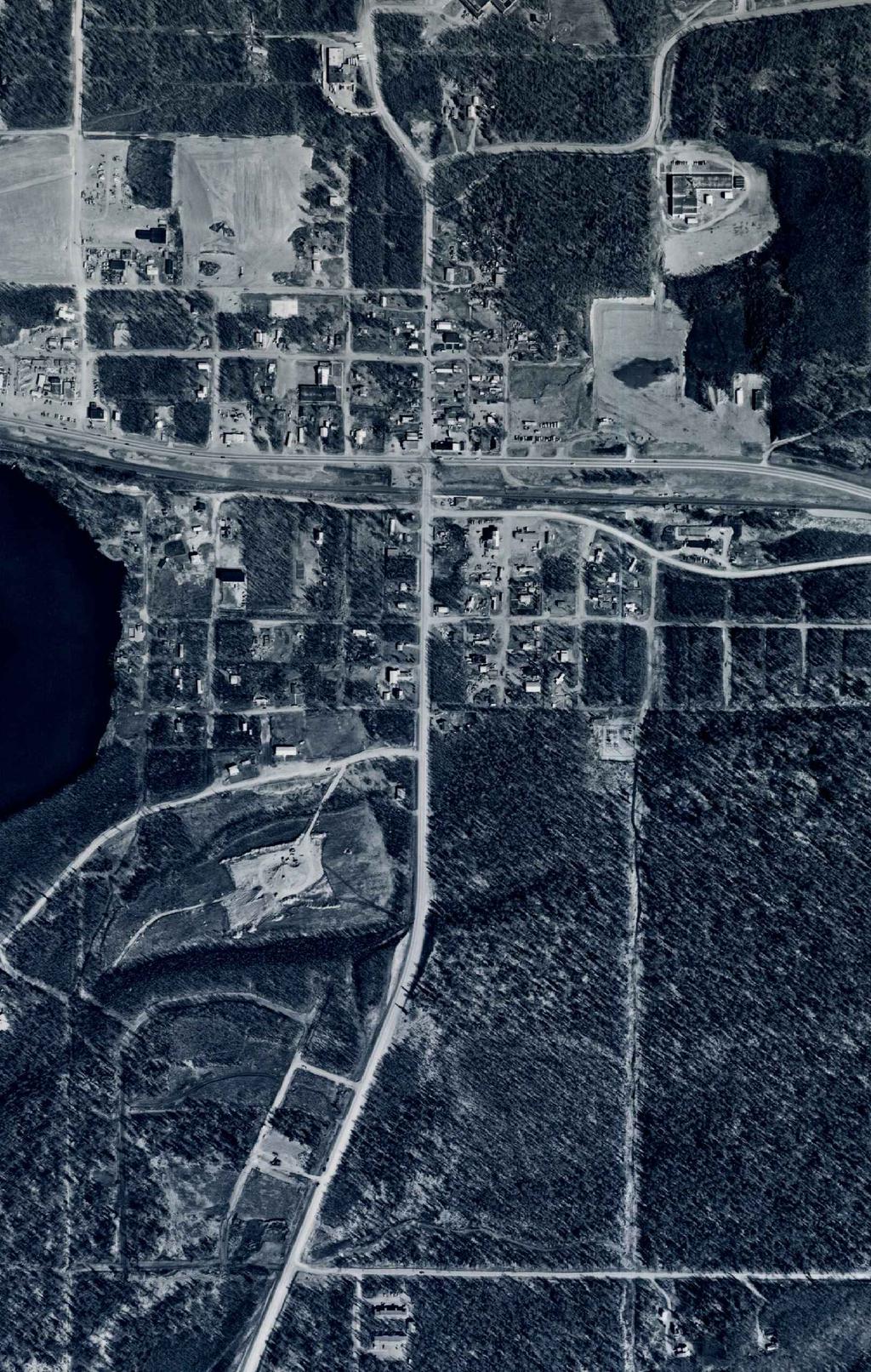
16 4.0 RECORDS REVIEW The purpose of the records review was to identify previous activities that may have constituted environmental misuse and/or contributed to the presence of waste residuals at the Project Area. Standard Environmental Record Sources and the Additional Environmental Record Sources identified in ASTM E were reviewed to the extent reasonably ascertainable and likely to be useful. 4.1 Aerial Photographs The photographs for the years 1951, 1966, 1971, 1977, 1983, 1989, 1995, 2002, and 2011 were reviewed at Aero-Metric USA, Inc. and a photograph for the year 2004 was reviewed using Google Earth Pro. The photos included in this report are from 1951, 1977, 1989, and These photos are included as Figures 4 through 7, respectively, and are each enlarged to an approximate scale of 1 inch equals 400 feet. The approximate Project Area is shown in red on the figures for reference. The August 10, 1951 photograph is included as Figure 4. Main Street is an unpaved two lane Road. Several structures have been constructed along either side of Main Street. Boundary Street, to the east of Main Street, has been partially cleared but not constructed. A portion of Swanson Avenue and Knik Street have been constructed to the west of Main Street. Structures have been constructed along these roads. KGB Road is present as a two lane, unpaved road continuing to run north-south beginning where Main Street ends at the train tracks. A train depot has been constructed to the east of this intersection. Railroad Avenue is an unpaved road that runs parallel to the train tracks. Two commercial structures have been constructed along the south side of Railroad Avenue. A portion of Talkeetna Street has been cleared, but remains undeveloped. Two structures have been constructed further south on KGB Road. The remaining portions of the Project Area are mostly vegetated and undeveloped. In the 1966 photograph, Main Street, Knik Street and Willow Street have been widened. More structures have been constructed along these streets. The land east of Boundary Street remains undeveloped and vegetated. New and existing roads south of the railroad tracks have been constructed and improved, respectively. Multiple commercial structures have been built on the land east of KGB Road and south of Railroad Avenue. Vehicle and heavy machinery storage is also visible in this area. Talkeetna Street has been cleared, and is an unpaved two lane roadway. The 1971 photo is similar to the 1966 photo. Main Street appears paved and is connected to Wasilla Fishhook Road to the north. A structure has been constructed at this intersection. Development of structures has occurred along Main Street, KGB Road, and the roadways to the east and west. Phase I Environmental Site Assessment, Wasilla Main Street Rehabilitation, Wasilla, Alaska
17 The May 12, 1977 photograph is included as Figure 5. The structures along Main Street and KGB Road are similar to those seen in the 1971 photo. Bogard Road has been widened and paved. The Parks Highway is a two lane paved road which has been constructed running parallel north of the railroad tracks. The southern portion of Yenlo Street has been cleared. Vehicle storage is present on the parcel adjacent east of Yenlo Street and north of the Parks Highway. Increased vehicle storage is present on parcels adjacent to KGB Road and along Boundary Street. An electric substation has been constructed at the end of Denali Street, adjacent to Talkeetna Street. In the 1983 photograph, new roadways have been constructed to the east and west of Main Street. Some structures along Main Street appear to be improved. Structures east of Main Street have been replaced with larger structures. The southern portion of Yenlo Street has been further established and extended north. A commercial structure has been built on the parcel adjacent east of Yenlo Street. The northern portion of Yenlo Street remains vegetated. The May 9, 1989 photograph is included as Figure 6. Commercial structures have been constructed along the northern portion of Main Street. Two filling stations have replaced former structures located at the Main Street and Parks Highway intersection and the Boundary Street and Parks Highway intersection. The Parks Highway has been widened to a four-lane road. Larger structures have replaced structures to the east and west of Main Street. Increased vehicle storage is present along KGB Road and Talkeetna Street. Parcels have been cleared, and structures have been built along the southern portion of KGB Road. In the 1995 photograph, the Project Area appears much as it did in the 1989 photo. The northern portion of Yenlo Street has been cleared, and appears to be a gravel pit with two small structures on the adjacent parcel. The southern portion of Yenlo Street appears to be paved. The southern portion of the Talkeetna/Yenlo Corridor remains forested. In the 2002 photo, the structures seen on the parcel adjacent to Yenlo Street in the 1995 photo have been removed. The parcel appears to be utilized as a gravel pit. Commercial structures have been constructed east of Yenlo Street. The 2004 photo, viewed on Google Earth Pro appears similar to the 2002 photo for the area to the north of the Parks Highway. Talkeetna Street appears darker in color than other gravel areas, but due to the timing of the photo it is unclear if this is due to seasonal melt or the application of dust suppressants such as oil or chloride-based chemicals. Vegetation south of Talkeetna Street has been cleared and a drainage ditch has been constructed. A fenced-in storage lot and several structures have been constructed west of the Talkeetna/Yenlo Corridor. A portion of the Talkeetna/Yenlo Corridor remains forested. The southern-most 200 feet of the corridor has been cleared. Phase I Environmental Site Assessment, Wasilla Main Street Rehabilitation, Wasilla, Alaska
18 The May 24, 2011 aerial photograph is included as Figure 7. Structures adjacent to Main Street appear much as they did in the 2004 photo. Stockpiled material and vegetated areas are seen on the northern portion of Yenlo Street. Structures have been constructed adjacent to Yenlo Street, at its intersection with Swanson Avenue. Talkeetna Street remains unpaved and appears to be treated for dust suppression. Due to the quality of the earlier photographs it is not clear if this is a regular, historical operation or a onetime application. Vegetation south of Talkeetna Street has been cleared and a drainage ditch has been constructed. 4.2 Physical Setting Geologic, hydrogeologic, hydrologic, and topographic characteristics of the Project Area were researched to develop an understanding of the physical setting of the Project Area and surrounding area Groundwater Characteristics The local groundwater flow direction and gradient was not established as part of this project. The Project Area is located between Wasilla Lake (east) and Lucile Lake (west). Based on institutional knowledge, regional groundwater flow is to the south. The State of Alaska Well Log Tracking System (WELTS) was researched to provide information about drinking water wells on or near the Project Site. The WELTS database, reviewed on August 10, 2011, does not identify drinking water wells within the Project Area. Structures on parcels adjacent to the Project Area predate city water and could potentially have drinking water wells onsite Soils/Geology Information used in this discussion of soils and geology was provided by the Alaska Geological Society. The surface elevations in the Mat-Su Borough range from sea level where the Knik River and Matanuska River enter the Cook Inlet, to greater than 6,000 feet in the peaks that bound the area. The land in this area generally slopes toward the Knik Arm. Glacial moraine and outwash deposits primarily mantle the surface of the Mat-Su Valley. The terrain is dominated by distinctive landforms created by repeated glacial advances and retreats during the Pleistocene epoch Historical Maps A 1994 USGS 1:25,000 Topographic Map was reviewed. The map depicts a portion of the Project Area and several adjacent parcels as developed. KGB Road, Main Street Road and Phase I Environmental Site Assessment, Wasilla Main Street Rehabilitation, Wasilla, Alaska
19 Talkeetna Street are established. Multiple structures have been constructed along the east and west sides of the northern portion of KGB Road, Main Street and Talkeetna Street. While Yenlo Street is not visible on the map, several structures have been constructed to its east and west. A 1950 historical USGS 1:63,360 Topographic Map was also reviewed. The map depicts the KGB Road ROW and Main Street ROW as developed. Structures are present along KGB Road and Main Street. Talkeetna Street and Yenlo Street have not been constructed. The majority of the surrounding parcels are undeveloped and vegetated. 4.3 Regulatory Database Search Federal and state database records were researched from July 28, 2011 through August 1, 2011 for pertinent information regarding the environmental condition of the Project Area and adjacent parcels. In addition, local agency sources were contacted as part of the database search. This database search complies with ASTM E , with the exceptions noted in Section Federal Records Sources The National Priorities List (NPL) specifies those properties assigned the Environmental Protection Agency s (EPA) highest cleanup priority. The EPA website was reviewed for active NPL sites in Alaska. There are no listed NPL sites in the Wasilla area. The Comprehensive Environmental Response, Compensation, and Liability Information System (CERCLIS) is also compiled by the EPA and includes sites the EPA has investigated or is currently investigating for potential hazardous substance contamination for possible inclusion on the NPL. According to the CERCLIS list, viewed on the EPA website August 1, 2011, no CERCLIS sites are located in the Wasilla area. According to the EPA Region 10 report, there are no Resource Conservation and Recovery Act (RCRA) treatment, storage, or disposal (TSD) facilities subject to corrective action (CORRACTS) within 1 mile of the Project Area. TSD facilities not subject to corrective action (NONCORRACTS) are not located within 0.5 mile of the Project Area. The Emergency Response Notification System (ERNS) lists reported hazardous substance releases in quantities greater than the reportable quantity. The Project Area is not on the ERNS list. According to the Brownfield list, there are no EPA Brownfield Assessment, Cleanup, and Revolving Loan Fund Grantees in Wasilla. Phase I Environmental Site Assessment, Wasilla Main Street Rehabilitation, Wasilla, Alaska
20 4.3.2 State Records Sources Registered Underground Storage Tank Database The ADEC registered Underground Storage Tank (UST) records, available on the ADEC website, were viewed on July 27, Information regarding the registered UST sites listed on the database is summarized in Table 1. The ADEC records indicate that registered UST sites are not located with the Project Area. Seven registered UST sites are present within 0.25 mile of the Project Area. There are three parcels adjacent to the Project Area listed as ADEC registered UST sites. According to the database, two 10,000-gallon gasoline tanks and one 5,000-gallon diesel tank were removed from the ground at the site identified as 2 Go Mart Tesoro Northstore #12, adjacent along Main Street located at 211 North Main Street. There are two 15,000-gallon gasoline tanks currently in use at this site. The second adjacent UST listing is for the Wasilla Public Safety Building located at Main Street and Herning Avenue. According to the database, two 500-gallon gasoline tanks were removed from the ground. The third adjacent UST listing is A&B Tool & Equipment Rental, located at 450 Railroad Avenue, adjacent along KGB Road. According to the database, one 3,000-gallon diesel tank, one 2,000-gallon gasoline tank, and one 1,000-gallon gasoline tank have been removed from the ground. The Holiday Station Store #605 is located about 90 feet west of Yenlo Street, along the Parks Highway. According to the database, one 10,000-gallon and two 5,000-gallon gasoline tanks and one 5,000-gallon diesel tank have been removed from the ground. One 10,000-gallon gasoline tank and one 10,000-gallon diesel tank are currently in use at the site. The remaining registered UST sites are located 175 feet or more from the Project Area. Leaking Underground Storage Tank Database The ADEC s Leaking Underground Storage Tank (LUST) database was reviewed on July 28, 2011, for information regarding LUST sites within 0.5 mile of the Project Area. Information regarding the LUST sites listed on the database is summarized in Table 2. ADEC records do not identify LUST sites within the Project Area. Phase I Environmental Site Assessment, Wasilla Main Street Rehabilitation, Wasilla, Alaska
21 There are eight LUST sites and 15 recorded events located within 0.5 mile of the Project Area. The following is a synopsis of the adjacent LUST sites and the nearest open LUST site to the Project Area, respectively. The parcel adjacent to the east of the KGB/Main Street, the Tesoro filling station at 211 North Main Street, was added to the ADEC LUST database in 2007 when during the removal of two 10,000 gallon gasoline USTs, one 5,000 gallon diesel UST, and associated piping, diesel range organics (DRO) contamination was found in soil and groundwater. Gasoline range organics (GRO) contamination was also found in the groundwater above allowable cleanup levels. According to the ADEC database, contaminated soil was removed from the site. After follow up soil and groundwater sampling, site closure was approved in The Wasilla Public Safety Building #61 is adjacent to the KGB/Main Street Corridor, located at Main Street and Herning Avenue. This site was added to the ADEC LUST database in 1991 after a release from a UST was confirmed. Cleanup was initiated in the same year. Site closure was approved in A & B Tool Equipment Rental is located at 450 Railroad Avenue, adjacent to the KGB/Main Street Corridor. This site was added to the ADEC LUST database on November 20, According to the database report, 67 cubic yards of contaminated soil was excavated and spread onsite. The site was closed on November 22, The nearest open LUST site to the Project Area is Tundra Tours, located at 300 East Danna Avenue, approximately 175 feet northwest of the KGB/Main Street Corridor. The site was added to the ADEC LUST database in 1995 when contaminated soils were discovered during the excavation of diesel and gasoline USTs. The contaminated soil was stockpiled onsite and requested to be thermally treated. As of 2006, there was no ADEC file available for the site and according to the ADEC there is not enough information in the database entries to formulate an accurate or meaningful ranking, so the site remains open. There are no other identified open LUST sites listed within 0.5 miles of the Project Area. The remaining registered LUST sites are located 175 feet or more from the Project Area. Contaminated Sites Database The ADEC Contaminated Sites database was reviewed on July 27, 2011, for sites within 1 mile of the Project Area. This list is assumed to be equivalent to a State Hazardous Waste Sites list, as required by ASTM E Eleven contaminated sites within 1 mile of the Project Area are listed on the database. Information regarding the contaminated sites is summarized in Table 3. Phase I Environmental Site Assessment, Wasilla Main Street Rehabilitation, Wasilla, Alaska
22 The ADEC database does not list any contaminated sites within the Project Area. The closest contaminated site, located adjacent east of the KGB/Main Street Corridor, is Wasilla City Museum at 323 North Main Street. According to the ADEC contaminated sites database, the site was added in September 1990 after diesel contamination of the soil was encountered during the removal of a heating oil tank. The site was closed by the ADEC in November 1990 after soil samples confirmed contamination levels below the ADEC cleanup levels. The closest active contaminated site, located approximately 900 feet southwest of the KGB/Main Street Corridor, is the Knik Texaco Service. The site was added to the database in 1992 when waste oil was dumped behind a building. Soil samples collected from the site showed contamination includes but is not limited to the following: DRO, residual range organics (RRO), benzene, polychlorinated biphenyls (PCBs), and arsenic. There is also potential contamination from discharge of floor drains to the onsite septic system. Ongoing soil and water monitoring occurs at the site. There is one other listed active contaminated site within one mile of the Project Area. This is the Dodge Electric/Fall Equipment Company site located approximately 1,300 feet west of the Project Area. The remaining sites are listed as cleanup complete on the ADEC database. Detailed evaluations of these listed sites were outside the scope of this assessment, and we cannot form definitive opinions regarding their potential impact to the Project Area. Based on our experience, however, it is unlikely these sites will impact the Project Area based on considerations of distance to the Project Area; typical release, fate, and transport mechanisms; and the ADEC s assessed cleanup priorities. Spills List The ADEC Spills List was reviewed for information regarding spills within the Project Area. The list does not indicate that a spill has occurred within the Project Area. It is noted that multiple spills are listed at parcels adjacent to the Project Area. One spill is listed at 211 Parks Highway, the Tesoro filling station adjacent to Main Street. The majority of these events are from the Holiday filling station, located at 255 Boundary Avenue, approximately 90 feet west of Yenlo Street. Four of the spills listed are from the ARRC. Addresses for these spill sites were not listed on the ADEC Spills List. Two of the spills listed are from MTA. Addresses are not listed for these sites. One spill listed is from an abandoned drum on Railroad Avenue. The location of the drum was not listed on the Spills List. It is unknown if these events have impacted the Project Area. Phase I Environmental Site Assessment, Wasilla Main Street Rehabilitation, Wasilla, Alaska
23 State Landfill/Solid Waste List The State Landfill/Solid Waste Disposal Site List was reviewed. According to the ADEC s Solid Waste Management database, no landfills or solid waste disposal sites are identified within 0.5 mile of the Project Area Local Agency Sources The Office of Public Works for the City of Wasilla was contacted on August 9, 2011 to gather information about water and sewer mains in the area. According to the Office of Public Works, water and sewer mains within the KGB/Main Street Corridor and the northern portion of the Talkeetna/Yenlo Corridor were installed in 1981 and 1986, respectively. Water and sewer mains within the southern portion of the Talkeetna/Yenlo Corridor and northern portion of the KGB/Main Street Corridor were installed between 1983 and The KGB water line was installed in This runs from the Susitna Avenue south along KGB Road to the Palmer- Wasilla Highway. Based on aerial photograph review, with the exception of the southern portion of the Talkeetna/Yenlo Corridor, former and existing structures on parcels adjacent to the Project Area predate the availability of city water and sewer services. ENSTAR as-built records were researched to determine when natural gas service was available to the Project Area and the adjacent sites. According to ENSTAR records, a natural gas main was installed running east-west along the Parks Highway in Natural gas mains were installed in 1984 running north-south along KGB Road, Main Street, Talkeetna Street, Knik Street, and Boundary Street. In 1990, the gas main along KGB Road was extended south. Natural gas mains were installed running east-west along Lakeview Street, Park Avenue, Susitna Avenue, Herning Avenue, and Swanson Avenue in The parcels adjacent to the Project Area were connected in years ranging from 1984 to Based on aerial photograph review, with the exception of the southern portion of the Talkeetna/Yenlo Corridor, former and existing structures on parcels adjacent to the Project Area predate the availability of natural gas services. 5.0 SITE RECONNAISSANCE Shannon & Wilson representative (Ms. Jessa Tibbetts) conducted a visual site reconnaissance on August 3, 2011 and again on October 18, Photographs taken during the site reconnaissance are included in Appendix C. Adjacent parcels and structures were not entered during the site reconnaissance. Phase I Environmental Site Assessment, Wasilla Main Street Rehabilitation, Wasilla, Alaska
24 5.1 Property Grounds Evaluation The Project Area is bounded by the intersection of KGB Road and the Palmer-Wasilla Highway to the south and Bogard Road running east-west to the north. The Project Area consists of roadways, commercial structures, cleared and vegetated land. The KGB/Main Street Corridor includes a portion of KGB Road, which is a paved two lane road that begins approximately 350 feet north of Palmer-Wasilla Highway (Photo 1) and ends at the ARRC tracks. Bike paths run parallel to the roadway. The corridor continues north across the ARRC tracks and the Parks Highway onto Main Street, a paved three lane road that ends on Wasilla-Fishhook Road, approximately 250 feet north of the Bogard Road intersection (Photo 2). The Talkeetna/Yenlo Corridor begins at KGB Road and continues northeast through a cleared parcel onto an undeveloped, forested parcel until it intersects what would be the extension of the Talkeetna Street ROW. The southern portion of the Talkeetna Street ROW extension is a drainage ditch, (Photo 3). The corridor continues north along Talkeetna Street, which is an unpaved two lane road. It has rained just prior to the site visit and the unpaved roadways were still wet/damp from the rain. There appeared to be darker soil in the vicinity of 450 Talkeetna Street, where heavy machinery was stored. The portion of Talkeetna Street between East Railroad Avenue and East Susitna Avenue appeared to be darker than the portion of Talkeetna Street south of East Susitna Avenue. This could be due to historical dust suppression efforts or releases; however the source of the staining was not identified. The corridor continues north, across the ARRC tracks and the Parks Highway onto Yenlo Street, which is a paved two-lane road, (Photo 4). Approximately 400 feet south of Bogard Road, Yenlo Street becomes unpaved and is no longer an established roadway. Gravel piles with some vegetation and concrete and asphalt debris were observed in this location (Photos 5 and 6). The corridor continues 90 degrees to the west along Bogard Road, a paved two-lane road, until it ends at the Main Street intersection. 5.2 Surrounding Properties Evaluation The KGB/Main Street Corridor Weld Air is located adjacent west of KGB Road, along Centaur Avenue (Photo 7). Pressurized gas canisters were observed in the Weld Air Storage Lot (Photo 8). Commercial, retail, and residential structures are located along KGB Road, including a carwash, equipment rental shop, and a church. The train depot is located southeast of the KGB Road and Parks Highway intersection (Photo 9). A Tesoro filling station is located northeast of the Main Street and Parks Highway intersection (Photo 10). A pawn shop is located adjacent north of the filling station (Photo 11). Multiple vehicles and snow machines were observed in the pawn shop s storage lot Phase I Environmental Site Assessment, Wasilla Main Street Rehabilitation, Wasilla, Alaska
25 (Photo 12). Commercial structures, restaurants, the Mat-Su Valley Credit Union, the Wasilla City Library, a US Post Office, pawn shop, a fire station, and retail shops are located on parcels adjacent to Main Street. A residential structure is located east of Wasilla-Fishhook Road. The Talkeetna/Yenlo Corridor The corridor begins at KGB Road and heads northeast onto a cleared parcel, and continues onto undeveloped, forested land. Power lines run parallel to the corridor to the east as it follows a drainage ditch along the would-be Talkeetna ROW extension. An unpaved, fenced-in storage lot (Photo 13) and shopping center are located west of the Project Area. An electric substation is located adjacent east of the Talkeetna/Yenlo Corridor, (Photo 14). A mini-storage lot is located at the end of the Talkeetna Street ROW is also located in this area (Photo 15). Residential structures are located east and west of Talkeetna Street and south of Susitna Avenue. A restaurant, residential structures, and heavy machinery yard and operations building are located adjacent to Talkeetna Street (Photo 16). Tractors, a backhoe, dump trucks, vehicles, a boat, multiple storage annexes and an above ground storage tank were observed on the Talkeetna Street parcel (Photos 17 & 18). The corridor continues across Parks Highway onto Yenlo Street. Medical offices, retail shops, restaurants, and an insurance company are located west of Yenlo Street. A Carrs/Safeway grocery store and strip mall are located east of Yenlo Street. The Yenlo Apartments are located north of Swanson Avenue, along Yenlo Street. The most northern portion of the Talkeetna/Yenlo Corridor is partially vegetated with piles of gravel material. A church, residential structure and bank are located adjacent to this portion of the Project Area. 5.3 Hazardous Substances and Petroleum Products Hazardous substances and petroleum products were not observed within the Project Area. Aerial photos show oil may have been spread on Talkeetna Street. During the site reconnaissance, gravel along Talkeetna Street appeared to be stained. Operations at a parcel along Talkeetna Street include heavy machinery storage and an aboveground storage tank. The contents of the tank could not be identified from offsite observation. An active filling station is located adjacent to the Main Street/Parks Highway intersection. Approximate locations of these sites can be seen on Figure Drums Drums were not observed within the Project Area. A 55-gallon drum was observed in a storage lot on Boundary Street, approximately 200 feet west of the Talkeetna/Yenlo Corridor. The approximate location of this drum is shown on Figure 2. Phase I Environmental Site Assessment, Wasilla Main Street Rehabilitation, Wasilla, Alaska
26 5.5 Asbestos-Containing Materials Structures are not located within the Project Area, therefore asbestos-containing materials (ACMs) and/or lead-based paint from current structures is not a concern. 5.6 Transformers Five pole-mounted transformers were observed along the Main Street Corridor as shown in Figure 3. There were stickers from Matanuska Electric Association (MEA) indicating that the transformers did not contain PCBs. 5.7 Solid Waste Disposal Based on our visual observations, records review, and interviews, the Project Area was not used for disposal of construction debris, demolition debris, or other solid waste. Concrete and asphalt debris were observed along the Yenlo Street ROW. 6.1 Government Official 6.0 INTERVIEWS On August 2, 2011, Mr. Paul Horwath, Ms. Keather Mcloone, and Mr. Robert Weimer, Project Managers at the ADEC Division of Contaminated Sites, were contacted. Mr. Horwath is the Project Manager for the Tesoro Northstore # LUST site, located adjacent to the Main Street Corridor. According to Mr. Horwath, the contaminant of concern was DRO, which was detected in groundwater monitoring wells downgradient from the site. As DRO doesn t create very large dissolve-phase plumes in groundwater, he doesn t believe it has reached the Main Street ROW. Mr. Horwath also stated that the gas station is still active and he has no other soil or groundwater quality data or information concerning the site conditions since the closure was issued as to whether or not any additional release may have occurred from the current gas station operations. Ms. Mcloone is the Project Manager for the Holiday Station Store #605 LUST site located 90 feet west of the Yenlo Street Corridor. According to Ms. Mcloone, the most recent four events of groundwater sampling suggest that the groundwater is no longer contaminated above acceptable ADEC clean up levels; therefore it is unlikely that the previously documented contamination at the Holiday Site would impact the Project Area. Mr. Weimer is the Project Manager for the active contaminated site located at 1800 KGB Road, approximately 900 feet southwest of the KGB/Main Street Corridor. According to Mr. Weimer, the full extent of the soil and groundwater contamination has not been defined at the Phase I Environmental Site Assessment, Wasilla Main Street Rehabilitation, Wasilla, Alaska
27 Knik Texaco site. The groundwater flow at the site is generally to the southwest away from the Project Area. 7.0 OTHER ENVIRONMENTAL CONSIDERATIONS High Voltage Power Lines. During the site visit, potentially high-voltage power lines were observed running north-south approximately 200 east of the Talkeetna/Yenlo Corridor. These power lines run to and from a MEA substation located at the end of Denali Street, adjacent to the Talkeetna/Yenlo Corridor, shown on Figure 2. Lead in Drinking Water. The City of Wasilla Public Works Department was contacted by telephone in July According to the water quality representative, Wasilla does not have a history of lead in the drinking water. The City of Wasilla has not historically and does not currently utilize lead pipes in the construction of water mains. Wetlands and Surface Waters. According to the U.S. Army Corps of Engineers and the EPA, wetlands are defined as areas that are inundated or saturated by surface or groundwater at a frequency and duration sufficient to support, and that under normal circumstances do support, a prevalence of vegetation typically adapted for life in saturated soil conditions. Three indicators are used to identify wetlands: (1) vegetation, (2) soil, and (3) hydrology. According to the U.S. Fish and Wildlife Service (USFWS) National Wetlands Inventory map, wetlands are not present on the Project Area. According to the Mat-Su Borough Wetlands Map, the Project Area is not designated as a wetland. The nearest wetland is located approximately 1,300 feet west of the Project Area. Cultural, Historic, and Archeological Resources. The National Register of Historic Places is the Nation's official list of cultural resources worthy of preservation. The National Register s database does not list cultural resource sites or cultural resource districts located within the Project Area. Seven sites are listed on the register in the Wasilla area. Five of these sites are located between the KGB/Main Street Corridor and the Talkeetna/Yenlo Corridor, along Boundary Street, as shown on Figure 3. The Alaska Department of Natural Resources, Office of History and Archaeology maintains a restricted statewide inventory of reported historic, prehistoric, and archaeological resources. The inventory of cultural resources includes objects, structures, buildings, sites, districts, and travel ways, with a general provision that they are over 50 years old. Considering the Project Area has been used as a roadway or is land that was not developed until after the 1960s, it is unlikely there are reported historic, prehistoric, and archaeological resources at the site. It is unlikely that there are recorded cultural, historic, or archeological sites on the Project Area. Phase I Environmental Site Assessment, Wasilla Main Street Rehabilitation, Wasilla, Alaska
28 Threatened and Endangered Species. According to the United States Fish and Wildlife Service (USFWS), 14 threatened and/or endangered animal species and one endangered plant species exist in Alaska. Five animal species are considered endangered by the Alaska Department of Fish and Game, Division of Wildlife Conservation. These federal and state listed species are not found in the Wasilla area. Wildlife Sanctuaries and Other Natural Resource Preserves. The USFWS database does not list the Project Area as a wildlife sanctuary. 8.0 FINDINGS AND CONCLUSIONS We have performed a Phase I Environmental Site Assessment in conformance with the scope and limitations of ASTM Practice E , of the Project Area in downtown Wasilla, Alaska. Exceptions to, or deletions from, this practice are described in Section 1.3 of this report. No environmental conditions were identified at the Project Area. Multiple environmental conditions were identified at adjacent and surrounding parcels. Based on our opinion regarding the potential for a release, material threat of a release, or other threat to human health and the environment, we have classified the conditions as RECs, Historical RECs, or Other Environmental Conditions. The following list should not be construed as comprehensive. It is possible that environmental concerns in addition to those mentioned in this report are present at the subject Project Area. 8.1 Recognized Environmental Conditions A REC is the presence or likely presence of a hazardous substance or petroleum product under conditions that indicate an existing release, a past release, or a material threat of a release into structures on the Project Area or into the Project Area s ground, groundwater, or surface water. This assessment revealed no evidence of RECs in connection with the Project Area and the surrounding parcels except the following: On-Site Recognized Environmental Conditions Surface stains were observed on Talkeetna Street, located within the Project Area. This staining was observed during the aerial photograph review, most notably in the 2011 aerial photograph. Precipitation prior to the site visit limited observation of the staining while in the field; however, areas of darker soil were observed. The areas observed during the site visit included the soil in the vicinity of 450 Talkeetna Street, where heavy machinery was stored, and the portion of Talkeetna Street between East Railroad Avenue and East Susitna Avenue. The impact or source of released contaminants to the subsurface is unknown. Although ASTM contains Phase I Environmental Site Assessment, Wasilla Main Street Rehabilitation, Wasilla, Alaska
29 allowances for de-minimis conditions; Alaska regulations concerning the release of oil or hazardous substances do not recognize de-minimis conditions and also require cleanup of surface stained soil. Therefore, because the surface staining would likely result in an enforcement action, it is defined as a REC by ASTM There are currently no other onsite RECs identified for the Project Area Off-Site Recognized Environmental Conditions While there are no active LUST sites or open contaminated sites adjacent to the Project Area, it is noted there are two active filling stations within 90 feet. A Tesoro filling station is located adjacent to Main Street at 211 N Main Street. A Holiday filling station is located 90 feet west of Yenlo Street, at 225 N Boundary Street. These sites constitute a REC because of documented past releases of petroleum hydrocarbons and because they pose a material threat of a release of petroleum hydrocarbons that could impact the environment. It is important to note that ASTM allows the identification of a REC for a site that is in compliance with applicable laws. 8.2 Historical Recognized Environmental Conditions A Historical REC is an environmental condition that may have constituted a REC in the past, but has been closed by a regulatory agency or otherwise is no longer considered to pose a material threat On-Site Historical Recognized Environmental Conditions There are currently no on-site historical RECs identified for the Project Area Off-Site Historical Recognized Environmental Conditions Four LUST sites are located within 175 feet of the Project Area. The parcel adjacent east of Main Street is a Tesoro located at 211 N Main Street, was added to the ADEC LUST database in 2007 when during the removal of two 10,000 gallon gasoline USTs, one 5,000 gallon diesel USTs and associated piping, DRO contamination was found in soil and groundwater. GRO contamination was also found in the groundwater above allowable cleanup levels. Contaminated soil was removed from the site. After follow up soil and groundwater sampling, site closure was approved in The Wasilla Public Safety Building #61 is adjacent to Main Street, located at Main Street and Herning Avenue. This site was added to the ADEC LUST database in 1991 after a release from a UST was confirmed. Cleanup was initiated in the same year. Site closure was approved in Phase I Environmental Site Assessment, Wasilla Main Street Rehabilitation, Wasilla, Alaska
30 A & B Tool Equipment Rental is located at 450 Railroad Avenue, adjacent to KGB Road. This site was added to the ADEC LUST database on November 20, According to the database report, 67 cubic yards of contaminated soil was excavated and spread onsite. The site was closed on November 22, The closest contaminated site, located adjacent to Main Street, is Wasilla City Museum at 323 North Main Street. According to the ADEC contaminated sites database, the site was added in September 1990 after diesel contamination of the soil was encountered during the removal of a heating oil tank. The site was closed by the ADEC in November 1990 after soil samples confirmed contamination levels below the ADEC cleanup levels. 8.3 Other Environmental Conditions Other Environmental Conditions include known, suspected, or potential sources of hazardous substances or petroleum products that are not considered RECs due to (a) the absence of a confirmed release or other material threat, (b) insufficient information to sufficiently evaluate the condition, (c) de minimis conditions that are not expected to be subject to regulatory action or (d) exclusion from the ASTM definition of hazardous material (e.g. ACM). The following Other Environmental Conditions were identified on the Project Area: Based on aerial photographs, structures on parcels adjacent to the Project Area predate the availability of city water and sewer services. It is possible that private drinking water wells and septic tanks were and still are utilized in this area. Based on aerial photograph reviews, structures on parcels adjacent to the Project Area predate the installation of natural gas. The structures may have utilized fuel oil for heating purposes. It is unknown whether potential heating oil USTs were properly removed or abandoned in place. Releases from active and/or abandoned tanks could potentially impact the Project Area s subsurface soil and/or groundwater. 9.0 QUALIFICATIONS OF ENVIRONMENTAL PROFESSIONALS This Phase I Environmental Site Assessment was prepared by Ms. Jessa Tibbetts under the direct supervision of Mr. Dan McMahon. The Phase I ESA was reviewed by Mr. Stafford Glashan, P.E. These individuals have the specific qualifications based on education, training, and experience to assess a property of the nature, history, and setting of the Project Area, and they have developed and performed the all appropriate inquiries in conformance with the standards and practices set forth in 40 CFR Part 312. Shannon & Wilson declares that, to the best of our professional knowledge and belief, Mr. McMahon and Mr. Glashan meet the definition of Environmental Professional as defined in 40 CFR Phase I Environmental Site Assessment, Wasilla Main Street Rehabilitation, Wasilla, Alaska
31 10.0 CLOSURE/LIMITATIONS This report is an instrument of service prepared by Shannon & Wilson for the exclusive use of HDR herein referred to as the Client, and its affiliates. This report was prepared for the exclusive use of the Client for evaluating the Project Area as it relates to the environmental aspects discussed herein. The conclusions contained in this report are based on information provided from the observed site conditions, personal interviews, and other sources identified herein, and further assume that the conditions observed are representative of the conditions throughout the Project Area. The data presented in this report should be considered representative of the time of our site assessment. Changes due to natural processes or human activity can occur over time. In addition, changes in government codes, regulations, or laws may occur. Because of such changes beyond our control, our observations and interpretations applicable to this Project Area may need to be revised. In order to create a report on which the Client can rely, Shannon & Wilson worked closely with the Client and their representatives to develop the scope of services upon which all subsequent tasks have been based. No party other than the Client and its affiliates is permitted by Shannon & Wilson to rely on this instrument of Shannon & Wilson s service, except as stipulated in Section 1.4. With the permission of the Client, Shannon & Wilson will meet with a third party, approved in writing by the Client, to identify the additional services required, if any, to permit such third party to rely on the information contained in this report. Such reliance would be limited to the same extent of Client s reliance, and subject to the same contractual, technological and other limitations to which the Clients have agreed. Copies of documents that may be relied upon by our client are limited to the printed copies (also known as hard copies) that are signed or sealed by Shannon & Wilson with a wet, blue ink signature. Files provided in electronic media format are furnished solely for the convenience of the client. Any conclusion or information derived from electronic files shall be at the user s sole risk. If there is a discrepancy between the electronic files and the hard copies, or you question the authenticity of the report, please contact the undersigned. Shannon & Wilson has prepared the attachments in Appendix D, Important Information About Your Environmental Site Assessment/Evaluation Report, to assist you and others in understanding the use and limitations of our report. Phase I Environmental Site Assessment, Wasilla Main Street Rehabilitation, Wasilla, Alaska
32
33 TABLE 1 REGISTERED UNDERGROUND STORAGE TANKS WITHIN A 0.25-MILE RADIUS SHANNON & WILSON, INC. Facility Name Facility ID Street Address Owner Name Tank ID Tank Status Tank Capacity (gallons) Tank Contents Approximate Distance from Property 2 Go Mart-Tesoro Northstore # N Main Street Tesoro Refining and Marketing Company Tank removed from ground Tank removed from ground Tank removed from ground Currently In Use Currently In Use 10,000 10,000 5,000 15,000 15,000 Gasoline Gasoline Diesel Gasoline Gasoline Adjacent east of Main Street Wasilla Public Safety Bldg 262 Main St & Herning Ave Matanuska Susitna Borough 1 2 Tank removed from ground Tank removed from ground Gasoline Gasoline Adjacent east of Main Street A & B Tool & Equipment Rental Railroad Avenue Bill Byers Tank removed from ground Tank removed from ground Tank removed from ground 2,000 3,000 1,000 Gasoline Diesel Gasoline Adjacent east of KGB Road Holiday # N Boundary Street Holiday Alaska, Inc Tank removed from ground Tank removed from ground Tank removed from ground Tank removed from ground Currently In Use Currently In Use Currently In Use 5,000 10,000 5,000 5,000 20,000 10,000 10,000 Gasoline Gasoline Gasoline Diesel Gasoline Gasoline Diesel 90 feet west of Yenlo Street Tundra Tours, Inc Fishhook Road Tundra Tours, Inc. 1 2 Permanently Out of Use Permanently Out of Use 3,000 2,000 Diesel Gasoline 175 feet northwest of Main Street Master Auto Repair E Parks Highway Alaskan Starr Enterprises, Inc Tank removed from ground Tank removed from ground Tank removed from ground Tank removed from ground Tank removed from ground Tank removed from ground Tank removed from ground Tank removed from ground 4,000 4,000 12,000 12,000 12,000 3,000 6,000 11,000 Gasoline Gasoline Diesel Diesel Diesel Diesel Gasoline Gasoline 800 feet west of Main Street Donald G Fall E Swanson Donald G Fall 1 2 Tank removed from ground Tank removed from ground 2,000 2,000 Gasoline Diesel 1,350 feet west of Main Street February , Wasilla Main Street Rehabilitation, Wasilla, Alaska Table 1 / Page 1 of 1
34 TABLE 2 LEAKING UNDERGROUND STORAGE TANK SITES WITHIN A 0.5-MILE RADIUS SHANNON & WILSON, INC. Facility Name Street Address Status Office File ID* Approximate Distance From Property Tesoro - Northstore # N Main Street Cleanup Complete Adjacent east of Main Street Tesoro - Northstore # N Main Street Cleanup Complete Adjacent east of Main Street Wasilla Public Safety Building #61 Main Street Cleanup Complete Adjacent east of Main Street A & B Tool Equipment Rental 450 Railroad Avenue Cleanup Complete No File Number Adjacent east of KGB Road Williams Express Store # Boundary Street Cleanup Complete feet west Yenlo Street Williams Express Store # Boundary Street Cleanup Complete No File Number 90 feet west Yenlo Street Williams Express Store # Release 225 Boundary Street Cleanup Complete - Institutional Controls feet west Yenlo Street Holiday Station Store #605 - Former Williams Express Store # October 2002 Release 225 Boundary Street Cleanup Complete - Institutional Controls feet west Yenlo Street Tundra Tours - Wasilla Bus Barn 300 East Danna Avenue Open feet northwest of Main Street Campbell & Sons Fuel Service - AST 211 East Parks Highway Cleanup Complete No File Number 800 feet west of Main Street Master Auto Repair 211 East Parks Highway Cleanup Complete feet west of Main Street Texaco - Campbell & Sons 211 East Parks Highway Cleanup Complete No File Number 800 feet west of Main Street Wasilla Campbell & Sons 211 East Parks Highway Cleanup Complete feet west of Main Street Fall Equipment Shop 101 E. Swanson Avenue Cleanup Complete ,350 feet west of Main Street Valley Country Store II Bogard Road Cleanup Complete No File Number 2,600 feet northeast of Yenlo Street Notes: * The Office File ID is the ADEC file number. **Not on UST Database February , Wasilla Main Street Rehabilitation, Wasilla, Alaska Table 2 / Page 1 of 1
35 TABLE 3 CONTAMINATED SITES FROM ADEC DATABASE WITHIN A 1.0-MILE RADIUS SHANNON & WILSON, INC. Facility Name and Street Address Wasilla City (Doro. G. Page) Museum 323 North Main Street Automotive Shop 651 Railroad Avenue Office File ID~ Status/Priority Problem, as listed by ADEC* CS.NF Cleanup Complete During excavation of underground heating oil storage tank some contaminated soils were encountered. Impact to human health and extent of contamination unknown. Site closed out to DEC's satisfaction. Last staff assigned was Krieber. CS Cleanup Complete Site consists of 3 underground storage tanks, 3 drums, surface oil stains, 3 floor sumps and an unknown pipe casing into a concrete floor. Unknown health or environmental damages. Lot B Doug Nielson Subdivision. Last staff assigned were Kiehl and Krieber. Approximate Distance From Property Adjacent east 350 feet east Children's House 291 East Paulsen Avenue Knik Texaco Service 1800 Knik-Goose Bay Road Cleanup Complete Heating oil tank serving residence and day care was found to have rusted through and contaminated soils and shallow groundwater which fluctuates from about 7 to 12 feet below the ground surface. Two interim removals have occurred however remaining soils after the excavation still exceed cleanup levels. Groundwater was monitored initially on a scheduled basis and DRO was above its 1.5 mg/l cleanup level Active Waste oil was dumped behind building. Soils contaminated. Cleanup was to have been started on 04/18/90. Tax Parcel D15. A LUST Site exists at this location as well. See - Texaco 1.5 Mile Knik Road, Event ID 783, Reckey , Facility ID On August 18, 2006 three soil samples were collected at 1 to 2 feet below ground surface behind the building. The whole area of concern behind the building could not be assessed because of the presence of tires and drums. Up to 463 mg/kg DRO, 5, 180 mg/kg RRO, < mg/kg benzene, < mg/lg PCBs, and 10.3 mg/kg arsenic where the soil samples were collected. They did not collect GRO soil samples as required in the approved work plan. 400 feet west 900 feet southwest Notes: ~ The Office File ID is the ADEC file identification number * Narrative taken directly from ADEC summary statement in the on-line database. This summary may not fully describe the nature of the environmental concern and/or potential risk to human health safety, welfare, or the environment February , Wasilla Main Street Rehabilitation, Wasilla, Alaska Table 3 / Page 1 of 3
36 TABLE 3 CONTAMINATED SITES FROM ADEC DATABASE WITHIN A 1.0-MILE RADIUS SHANNON & WILSON, INC. Facility Name and Street Address Wasilla Machine Shop 300 North Willow Street Office File ID~ Status/Priority Problem, as listed by ADEC* Cleanup Complete Petroleum products and solvents used in cleaning engines being discharged on to ground and down drains. Impact to human health, extent and amount of contamination unknown. Soil above DRO and TPH cleanup levels were excavated and on 8/2/1995, stockpiled off site at Lot A2, Replat of Tract A, 3rd Addition Butler Subdivision near Big Lake Alaska. Lots 1, 2 and 3, Block 5, Wasilla Townsite. Last staff assigned were Krieber (2/12/97), Frechione and Sundet. See also CSRP database file "Wasilla Machine Shop" Regarding the soil stockpiled off site at Lot A2, Replat of Tract A, 3rd Addition Butler Subdivision near Big Lake, Alaska. Approximate Distance From Property 930 feet west Lot 2, Iditaway Park Subdivision 390 East Carpenters Circle Dodge Electric / Fall Equipment Co. 101 East Swanson Avenue Alaska Dyeworks 300 West Swanson Street #101 National Bank of Alaska - Wasilla 581 West Parks Highway CS Cleanup Complete Heating oil tank leaked unknown amount of fuel to soils. Groundwater contaminated and some soils excavated, stockpiled and treated off site. Total extent of contamination remaining is unknown. Potential exists for city water wells near site to become contaminated. Lot 2, Iditaway Park Subdivision. Denali North is managing property for Alaska Housing Finance Corp. Last staff assigned was Krieber. Not Listed Active Numerous extensive waste oil spills, extensive surface staining around fuel pumps. Tract B, Follet Industrial Tracts. LUST site also exists as Reckey , Event ID 1716, Facility ID Last staff assigned was Krieber (2/12/97). CS Cleanup Complete Discharge of Procion MX dyes, varying amounts of salt, Calgon water softener, soda ash, and synthrapol detergent into city sewer system. Alaska Dyeworks file is located in the CERCLA filing system with last correspondence dated 11/20/88 for status review of file. Last staff assigned was Kleweno Cleanup Complete - Institutional Controls Abandoned fuel oil tank leak. Groundwater contamination. Site assessment plan submitted 8/16/1991. Monitor wells installed. Have not received report of wells or assessment. Lot 12, Block 3, Snider Subdivision, Unit #4. Last staff assigned was Krieber. 900 feet north 1,300 feet west 2,425 feet west 4,000 feet west Old Wasilla Airport - Lot 2, Bl West Nelson Avenue Not Listed Cleanup Complete Toluene and methylene chloride in septic system. Surface oil stains by building. Assessment report 12/03/91. ADEC response 01/23/92, further investigation needed. Last staff assigned was Krieber. 4,300 feet west Notes: ~ The Office File ID is the ADEC file identification number * Narrative taken directly from ADEC summary statement in the on-line database. This summary may not fully describe the nature of the environmental concern and/or potential risk to human health safety, welfare, or the environment February , Wasilla Main Street Rehabilitation, Wasilla, Alaska Table 3 / Page 2 of 3
37 TABLE 3 CONTAMINATED SITES FROM ADEC DATABASE WITHIN A 1.0-MILE RADIUS SHANNON & WILSON, INC. Facility Name and Street Address Wasilla Speedy Auto & Window Glass 935 West Commercial Drive Office File ID~ Status/Priority Problem, as listed by ADEC* Cleanup Complete Floor drain showing solvents, toluene and xylene contaminants in soils. No groundwater contamination detected at site from site activities. Site closed out to DEC's satisfaction on 8/7/91 after excavation of contaminated soils to levels below cleanup guidelines. Westside Center Mall. Lot 44, Block 2, Wasilla Airport Heights Subdivision. David M Nyman, P.E.- ENSR Consulting and Engineering; 750 West 2nd Avenue; Suite 100; Anchorage, AK 99501, firm with site. Last staff assigned was Krieber. Approximate Distance From Property 4,850 feet west Notes: ~ The Office File ID is the ADEC file identification number * Narrative taken directly from ADEC summary statement in the on-line database. This summary may not fully describe the nature of the environmental concern and/or potential risk to human health safety, welfare, or the environment February , Wasilla Main Street Rehabilitation, Wasilla, Alaska Table 3 / Page 3 of 3
38 Vegetation Wasilla Middle School ARRC tracks Contaminated Site 651 Railroad Ave. Carrs Safeway /Strip Mall Denali Street Electric Substation Insert A Insert B Yenlo Street Talkeetna Street Danna Avenue Wasilla Fishhook Road UST & LUST Site 300 East Danna Ave. Nelson Road Bogard Road Main Street Contaminated Site 291 Paulsen Ave. Historic Sites Contaminated Site 323 N Main St. Knik Street Swanson Avenue Boundary Street UST & LUST Site Main St. & Herning Ave Herning Avenue UST, LUST Site 225 Boundary St. UST, LUST Site 211 Main St. Parks Highway Railroad Avenue UST Site 450 Railroad Avenue Knik Street Susitna Avenue Park Avenue Lake View Dr.. Weld Air Centaur Drive Vegetation Project Area Knik Goose-Bay Road Construction Site Palmer-Wasilla Highway Willow Street Contaminated Site 300 N. Willow Street Willow Street Residential Commercial Area Lake Street APPROXIMATE SCALE IN FEET Lake Lucille Wasilla Main Street Rehabilitation Wasilla, Alaska SITE PLAN February 2012 SHANNON & WILSON, INC. Geotechnical & Environmental Consultants Fig. 1
39 ARRC tracks Residential Structures Private Mini Storage facility Electric Substation Talkeetna Street AST Vegetation Heavy Machinery Storage Approx.. Stored Items location Unpaved lot Railroad Avenue UST Site 450 Railroad Avenue D Boundary Street Susitna Avenue Retail shops Lake View Drive Project Area Batteries Plus Store 609 S Knik-Goose Bay Rd Building under construction Knik Goose-Bay Road Retail and commercial buildings Park Avenue Weld Air property Key D Drum Wasilla Main Street Rehabilitation Wasilla, Alaska INSERT MAP A AST Above ground storage tank APPROXIMATE SCALE IN FEET February 2012 SHANNON & WILSON, INC. Geotechnical & Environmental Consultants Fig. 2
40 Carrs/Safeway Grocery Store Project Corridor Gravel Pit Retail Shops ARRC tracks Yenlo Street Apartment Structures Swanson Avenue UST, LUST Site 225 Boundary Street Parks Highway Project Area Bogard Road MatSu Valley Credit Union T US Post Office T Historic Sites T Fire Station Boundary Street UST & LUST Site Main St & Herning Ave T Pawn Shop T Train Depot UST & LUST Site 300 East Danna Ave. Nelson Road Key T Main Street Restaurants, medical offices, and retail shops Transformer Museum Contaminated Site 323 N Main St. Herning Avenue UST, LUST Site 211 Parks Highway Wasilla Main Street Rehabilitation Wasilla, Alaska INSERT MAP B APPROXIMATE SCALE IN FEET February 2012 SHANNON & WILSON, INC. Geotechnical & Environmental Consultants Fig. 3

41
42

43

44
45 APPENDIX A WASILLA MAIN STREET REHABILITATION PRELIMNEARY AREA OF POTENTIAL EFFECT MAP FIGURE PROVIDED BY HDR
46 This page intentionally left blank.
47 BO AR G D RD PALMER-WASILLA HWY TALKEETNA ST YENLO ST PARKS HWY Frontier Village Historical Park MAIN ST RD LUCILLE ST Project Location: Wasilla Legend Proposed Right-of-Way Proposed Road Corridor Existing Right-of-Way Subject to Additional Engineering Subject to Additional Engineering Frontier Village Historical Park FIGURE 2: WASILLA MAIN STREET REHABILITATION PRELIMINARY AREA OF POTENTIAL EFFECT MAP ³ OK -FISHHO WASILLA KNIK-GOOSE BAY RD Preliminary Area of Potential Effect (APE) Feet
48
49 APPENDIX B PHASE I ENVIRONMENTAL SITE ASSESSMENT QUESTIONNAIRE
50
51
52
53
54 This page intentionally left blank.
55 APPENDIX C SITE PHOTOGRAPHS
 Photo 2: North of the Main Street and Bogard Road intersection,")
 Wasilla Main Street Rehabilitation Wasilla, Alaska PHOTOS 1 PHOTOS AND")
56 Photo 1: The intersection of KGB Road and Palmer-Wasilla Highway. (August 3, 2011) Photo 2: North of the Main Street and Bogard Road intersection, looking south. (August 3, 2011) Wasilla Main Street Rehabilitation Wasilla, Alaska PHOTOS 1 PHOTOS AND 2 1 AND 2 February 2012 SHANNON & WILSON, INC. Geotechnical & Environmental Consultants C-1
 Photo 4: Yenlo Street, at Swanson Avenue intersection looking south.")

57 Photo 3: Drainage ditch located in the would-be extended Talkeetna Street ROW. (October 18, 2011) Photo 4: Yenlo Street, at Swanson Avenue intersection looking south. (August 3, 2011) Wasilla Main Street Rehabilitation Wasilla, Alaska PHOTOS 1 PHOTOS AND 2 3 AND 4 February 2012 SHANNON & WILSON, INC. Geotechnical & Environmental Consultants C-2
 Photo 6: Concrete and asphalt debris located in the northern portion of the Yenlo")
 Wasilla Main Street Rehabilitation Wasilla, Alaska PHOTOS 1 PHOTOS AND 2 5 AND 6")
58 Photo 5: Gravel material and vegetation located on the northern portion of the Yenlo Street ROW. (August 3, 2011) Photo 6: Concrete and asphalt debris located in the northern portion of the Yenlo Street ROW. (October 18, 2011) Wasilla Main Street Rehabilitation Wasilla, Alaska PHOTOS 1 PHOTOS AND 2 5 AND 6 February 2012 SHANNON & WILSON, INC. Geotechnical & Environmental Consultants C-3
 Photo 8: Compressed air canisters observed on the Weld Air property.")

59 Photo 7: The Weld Air facility located adjacent west of KGB Road. (August 3, 2011) Photo 8: Compressed air canisters observed on the Weld Air property. (August 3, 2011) Wasilla Main Street Rehabilitation Wasilla, Alaska PHOTOS 1 PHOTOS AND 2 7 AND 8 February 2012 SHANNON & WILSON, INC. Geotechnical & Environmental Consultants C-4
 Photo 10: The Tesoro filling station located adjacent to Main Street and the")
 Wasilla Main Street Rehabilitation Wasilla, Alaska PHOTOS PHOTOS 1 AND 2 9 AND")
60 Photo 9: The train depot, located adjacent east of the KGB/Main Street Corridor. (August 3, 2011) Photo 10: The Tesoro filling station located adjacent to Main Street and the Parks Highway. (August 3, 2011) Wasilla Main Street Rehabilitation Wasilla, Alaska PHOTOS PHOTOS 1 AND 2 9 AND 10 February 2012 SHANNON & WILSON, INC. Geotechnical & Environmental Consultants C-5
 Photo 12: Vehicle and snow machine storage at the pawn shop on Main Street.")

61 Photo 11: The pawn shop located along Main Street, adjacent north of the Tesoro filling station. (August 3, 2011) Photo 12: Vehicle and snow machine storage at the pawn shop on Main Street. (August 3, 2011) Wasilla Main Street Rehabilitation Wasilla, Alaska PHOTOS PHOTOS 1 AND 2 11 AND 12 February 2012 SHANNON & WILSON, INC. Geotechnical & Environmental Consultants C-6
 Photo 14: The MEA substation located at the end of Denali Street, adjacent east of the")
 Wasilla Main Street Rehabilitation Wasilla, Alaska PHOTOS PHOTOS 1 AND 2 13 AND 14")
62 Photo 13: Unpaved storage lot located west of the would-be extension of the Talkeetna Street ROW. (October 18, 2011) Photo 14: The MEA substation located at the end of Denali Street, adjacent east of the Talkeetna/Yenlo Corridor. (August 3, 2011) Wasilla Main Street Rehabilitation Wasilla, Alaska PHOTOS PHOTOS 1 AND 2 13 AND 14 February 2012 SHANNON & WILSON, INC. Geotechnical & Environmental Consultants C-7
 Photo 16: The intersection of Railroad Avenue and Talkeetna Street.")

63 Photo 15: Mini Storage facility located adjacent east of Talkeetna Street. (August 3, 2011) Photo 16: The intersection of Railroad Avenue and Talkeetna Street. (August 3, 2011) Wasilla Main Street Rehabilitation Wasilla, Alaska PHOTOS PHOTOS 1 AND 2 15 AND 16 February 2012 SHANNON & WILSON, INC. Geotechnical & Environmental Consultants C-8
 Photo 18: The above ground storage tank located on Talkeetna Street.")

64 Photo 17: Heavy machinery and storage along Talkeetna Street. (August 3, 2011) Photo 18: The above ground storage tank located on Talkeetna Street. (August 3, 2011) Wasilla Main Street Rehabilitation Wasilla, Alaska PHOTOS PHOTOS 1 AND 2 17 AND 18 February 2012 SHANNON & WILSON, INC. Geotechnical & Environmental Consultants C-9
65 APPENDIX D IMPORTANT INFORMATION ABOUT YOUR ENVIRONMENTAL SITE ASSESSMENT/EVALUALTION REPORT

66 SHANNON & WILSON, INC. Attachment to Report: Geotechnical and Environmental Consultants Dated: February 2012 To: HDR Alaska, Inc. Re: Phase I ESA, Wasilla Main Street Rehabilitation, Wasilla, Alaska Important Information About Your Environmental Site Assessment/Evaluation Report ENVIRONMENTAL SITE ASSESSMENTS/EVALUATIONS ARE PERFORMED FOR SPECIFIC PURPOSES AND FOR SPECIFIC CLIENTS. This report was prepared to meet the needs you specified with respect to your specific site and your risk management preferences. Unless indicated otherwise, we prepared your report expressly for you and for the purposes you indicated. No one other than you should use this report for any purpose without first conferring with us. No one is authorized to use this report for any purpose other than that originally contemplated without our prior written consent. The findings and conclusions documented in this site assessment/evaluation have been prepared for specific application to this project and have been developed in a manner consistent with that level of care and skill normally exercised by members of the environmental science profession currently practicing under similar conditions in this area. The conclusions presented are based on interpretation of information currently available to us and are made within the operational scope, budget, and schedule constraints of this project. No warranty, express or implied, is made. OUR REPORT IS BASED ON PROJECT-SPECIFIC FACTORS. Our environmental site assessment is based on several factors and may include (but not be limited to): reviewing public documents to chronicle site ownership for the past 30, 40, or more years; investigating the site's regulatory history to learn about permits granted or citations issued; determining prior uses of the site and those adjacent to it; reviewing available topographic and real estate maps, historical aerial photos, geologic information, and hydrologic data; reviewing readily available published information about surface and subsurface conditions; reviewing federal and state lists of known and potentially contaminated sites; evaluating the potential for naturally occurring hazards; and interviewing public officials, owners/operators, and/or adjacent owners with respect to local concerns and environmental conditions. Except as noted within the text of the report, no sampling or quantitative laboratory testing was performed by us as part of this site assessment. Where such analyses were conducted by an outside laboratory, Shannon & Wilson relied upon the data provided and did not conduct an independent evaluation regarding the reliability of the data. CONDITIONS CAN CHANGE. Site conditions, both surface and subsurface, may be affected as a result of natural processes or human influence. An environmental site assessment/evaluation is based on conditions that existed at the time of the evaluation. Because so many aspects of a historical review rely on third party information, most consultants will refuse to certify (warrant) that a site is free of contaminants, as it is impossible to know with absolute certainty if such a condition exists. Contaminants may be present in areas that were not surveyed or sampled, or may migrate to areas that showed no signs of contamination at the time they were studied. Unless your consultant indicates otherwise, your report should not be construed to represent geotechnical subsurface conditions at or adjacent to the site and does not provide sufficient information for construction-related activities. Your report also should not be used following floods, earthquakes, or other acts of nature; if the size or configuration of the site is altered; if the location of the site is modified; or if there is a change of ownership and/or use of the property. Page 1 of 2 7/2007
PHASE I ENVIRONMENTAL SITE ASSESSMENT
 PHASE I ENVIRONMENTAL SITE ASSESSMENT Commercial and Light Industrial Development Area North of Prairie Street Between Corbin and Shirley Avenues Northridge, California AES Project No. 02-225 June 13,
PHASE I ENVIRONMENTAL SITE ASSESSMENT 123 MAIN STREET SAN DIEGO, CALIFORNIA. September 15, 2002
 2847 Barnard Street San Diego California 92110 Phone 619.501.0185 Mobile 619.203.9774 Fax 619.501.9843 hoveyenv@cox.net Final Report PHASE I ENVIRONMENTAL SITE ASSESSMENT 123 MAIN STREET SAN DIEGO, CALIFORNIA
Appendix C Chapter 1 Initial Site Assessment Worksheet
 Appendix C Chapter 1 Initial Site Assessment Worksheet Contents Section 1 Overview...1-2...1-3 C-1-1 Section 1 Overview Section 1 Overview Disclaimer The following worksheet is an example and provides
REPORT ON PHASE I ENVIRONMENTAL SITE ASSESSMENT 1358 COKER STREET OSGOODE WARD, GREELY CITY OF OTTAWA, ONTARIO. Submitted to:
 Civil Geotechnical Structural Environmental Industrial Health & Safety 215 Sanders Street, Unit 1 (613) 860-0923 P.O. Box 189 Kemptville, Ontario K0G 1J0 FAX: (613) 258-0475 REPORT ON PHASE I ENVIRONMENTAL
IV.ENVIRONMENTAL IMPACT ANALYSIS H. HAZARDOUS MATERIALS
 IV.ENVIRONMENTAL IMPACT ANALYSIS H. HAZARDOUS MATERIALS This section summarizes a Phase I Environmental Site Assessment (ESA) Report prepared for parcels located at 11703, 11707 and 11715 San Vicente Boulevard
IV. ENVIRONMENTAL IMPACT ANALYSIS M. HAZARDS AND HAZARDOUS MATERIALS 1. ENVIRONMENTAL SITE ASSESSMENT
 IV. ENVIRONMENTAL IMPACT ANALYSIS M. HAZARDS AND HAZARDOUS MATERIALS 1. ENVIRONMENTAL SITE ASSESSMENT A Phase I Environmental Site Assessment (Phase I ESA) for the proposed project was prepared by Gradient
I-275 (State Road 93) Project Development & Environment Study
 Project Development & Environment Study") DRAFT CONTAMINATION SCREENING EVALUATION REPORT (POND SITES) I-275 (State Road 93) Project Development & Environment Study From north of Dr. Martin Luther King Jr Boulevard (SR 574) to north of Bearss
DRAFT CONTAMINATION SCREENING EVALUATION REPORT (POND SITES) I-275 (State Road 93) Project Development & Environment Study From north of Dr. Martin Luther King Jr Boulevard (SR 574) to north of Bearss
Phase I Environmental Site Assessment
 Phase I Environmental Site Assessment 97204 Prepared for: Multnomah County 401 NE Dixon Avenue, Suite 274 97227 TABLE OF CONTENTS 1.0 EXECUTIVE SUMMARY... 1 2.0 PROPERTY AND REPORT INFORMATION... 3 2.1
LOWER DUNGENESS RIVER SECTION 544 ECOSYSTEM RESTORATION
 LOWER DUNGENESS RIVER SECTION 544 ECOSYSTEM RESTORATION APPENDIX F HAZARDOUS, TOXIC AND RADIOACTIVE WASTE DRAFT Detailed Project Report and Environmental Assessment DUNGENESS RIVER ECOSYSTEM RESTORATION
Section 3.11: Hazardous Materials
 Section 3.11: Hazardous Materials Section 3.11 Hazardous Materials 3.11 HAZARDOUS MATERIALS 3.11.1 Introduction to Analysis This section provides information regarding known contaminated sites and general
Chapter 11: Hazardous Materials A. INTRODUCTION
 Chapter 11: Hazardous Materials A. INTRODUCTION This chapter relies on the analysis from the Fresh Kills Park Final Generic Environmental Impact Statement (FGEIS) and summarizes the conclusions drawn from
APPENDIX M: Hazardous Waste Technical Report
 APPENDIX M: Hazardous Waste Technical Report M.1 Existing Conditions A hazardous waste review was conducted to provide preliminary information regarding the potential presence of any hazardous substances
3.11 HAZARDOUS MATERIALS
 3.11 HAZARDOUS MATERIALS 3.11.1 Introduction to Analysis This section provides information regarding known contaminated sites and general areas of potentially contaminated properties along the proposed
ABBREVIATED PHASE I ENVIRONMENTAL SITE ASSESSMENT. January 2010
 ABBREVIATED PHASE I ENVIRONMENTAL SITE ASSESSMENT January 2010 ABBREVIATED PHASE I ENVIRONMENTAL SITE ASSESSMENT NORTHERN ACCESS TO THE U-MED DISTRICT ANCHORAGE, ALASKA DOT&PF Project No. 51838 Prepared
Johanna Heywood, PE, PG
 Johanna Heywood, PE, PG MEMPHIS BROWNFIELD WORKSHOP, SEPTEMBER 10, 2014 Past use of the site Chemicals used on-site Surrounding property usage Does not generally confirm or delineate contaminated areas
Environmental Site Assessment for Lenders April EPA All Appropriate Inquiry and. ASTM Phase I Environmental Site Assessment
 Environmental Site Assessment for Lenders April 2017 EPA All Appropriate Inquiry and ASTM Phase I Environmental Site Assessment 1 CONTENT 1. CERCLA Liability & AAI 2. Typical Contaminants Encountered 3.
patersongroup Phase I - Environmental Site Assessment Vacant Land, Strandherd Drive at Kennevale Drive Ottawa, Ontario Prepared For Regional Group
 Geotechnical Engineering patersongroup Environmental Engineering Hydrogeology Geological Engineering Materials Testing Building Science Vacant Land, Strandherd Drive at Kennevale Drive Ottawa, Ontario
DRAFT. Preliminary Evaluation. Analysis of Brownfields Cleanup Alternatives (ABCA)
") DRAFT Analysis of Brownfields Cleanup Alternatives (ABCA) Preliminary Evaluation Ball Square Station Site Boston Avenue and Broadway Somerville and Medford, Massachusetts Massachusetts DEP Release Tracking
DRAFT Analysis of Brownfields Cleanup Alternatives (ABCA) Preliminary Evaluation Ball Square Station Site Boston Avenue and Broadway Somerville and Medford, Massachusetts Massachusetts DEP Release Tracking
FACTS ABOUT: Former GE Power Systems Apparatus Service Center (Voluntary Cleanup Program) Site Location
 Site Location") Maryland Department of the Environment Site Location FACTS ABOUT: Former GE Power Systems Apparatus Service Center (Voluntary Cleanup Program) This 2.4581-acres site (Site) consists of four parcels of
Maryland Department of the Environment Site Location FACTS ABOUT: Former GE Power Systems Apparatus Service Center (Voluntary Cleanup Program) This 2.4581-acres site (Site) consists of four parcels of
FORM 4340 ENVIRONMENTAL QUESTIONNAIRE
 FORM 4340 ENVIRONMENTAL QUESTIONNAIRE ENVIRONMENTAL QUESTIONNAIRE Persons to be Questioned The following questions should be asked of the current owner of the property any commercial occupant of the property
CLEANUP ACTION PLAN COOK INLET HOUSING AUTHORITY 3607 & 3609 SPENARD ROAD ANCHORAGE, ALASKA OCTOBER 7, Prepared By:
 CLEANUP ACTION PLAN COOK INLET HOUSING AUTHORITY 3607 & 3609 SPENARD ROAD ANCHORAGE, ALASKA OCTOBER 7, 2016 Prepared By: SHANNON & WILSON, INC. 5430 Fairbanks Street, Suite 3 Anchorage, Alaska 99507 (907)
Prepared By: VERTEX Environmental Services, Inc. 400 Libbey Parkway Weymouth, MA May 18, Prepared For:
 Phase I Environmental Site Assessment 7 th Street Station 1100 Southwest 7 th Street Corvallis, Oregon 97333 VERTEX Project No. 18683 VERTEX Prepared By: VERTEX Environmental Services, Inc. 400 Libbey
APPENDIX H HAZARDOUS MATERIALS PROCEDURES AND RESULTS
 APPENDIX H HAZARDOUS MATERIALS PROCEDURES AND RESULTS Overview Hazardous materials and hazardous wastes are regulated by state and federal laws. These include not only specific statutes governing hazardous
Environmental Assessment. Appendix G Hazardous Materials Technical Report
 Environmental Assessment Appendix G Hazardous Materials Technical Report Hazardous Materials and Waste Sites Summary Technical Memorandum Kansas City Streetcar Main Street Extension December 20, 2018 DRAFT
New York State Department of Environmental Conservation August Receive Site Fact Sheets by . See "For More Information" to Learn How.
 New York State Department of Environmental Conservation August 2013 FACT SHEET Environmental Restoration Program Receive Site Fact Sheets by Email. See "For More Information" to Learn How. Site Name: 1201
12.0 Contaminated Materials
 12.0 Contaminated Materials 12.1 Introduction An investigation was performed to identify hazardous waste and contaminated material sites in the study area of the Columbia Pike Transit Initiative ( the
PHASE I ENVIRONMENTAL SITE ASSESSMENT REPORT
 PHASE I ENVIRONMENTAL SITE ASSESSMENT REPORT AIP #74 Various Properties South Burlington, Vermont 05403 October 14, 2011 Prepared for: Stantec Consulting Inc. 55 Green Mountain Drive South Burlington,
HAZARDOUS MATERIALS TECHNICAL REPORT
 Tri-County Parkway Location Study HAZARDOUS MATERIALS TECHNICAL REPORT Prepared for: The Virginia Department of Transportation Prepared by: Parsons Brinckerhoff Quade and Douglas, Inc. EEE Consulting,
PHASE ONE ENVIRONMENTAL SITE ASSESSMENT. Approximate One-Acre Lot of Land 5611 State Highway 359 Laredo, Texas. GETI Project No.
 PHASE ONE ENVIRONMENTAL SITE ASSESSMENT Approximate One-Acre Lot of Land 5611 State Highway 359 Laredo, Texas GETI Project No. 17-DE6098 Prepared For: 7B DEVELOPMENT Lubbock, Texas Prepared by: GEOSCIENCE
patersongroup Phase I Environmental Site Assessment Vacant, Undeveloped Land 1021 Thomas Spratt Place Ottawa, Ontario Prepared For
 Geotechnical Engineering patersongroup Environmental Engineering Hydrogeology Geological Engineering Materials Testing Building Science Phase I Environmental Site Assessment Vacant, Undeveloped Land 1021
Phase I Environmental Site Assessment
 Heights Plant Farm 2521 N Durham Drive Houston, TX 77008 October 29, 2015 Prepared for: Prosperity Bank 2310 Yale Street Houston, TX 77008 Prepared by: Your Environmental Business Partners 10101 Harwin
5.14 CONTAMINATED MATERIALS
 5.14 CONTAMINATED MATERIALS 5.14.1 Introduction Contaminated materials are toxic or potentially harmful substances that may be present in soil, groundwater, and building materials. Contaminated materials
I-85 Widening Project Cherokee County, South Carolina. Phase I Environmental Site Assessment
 I-85 Widening Project Cherokee County, South Carolina Phase I Environmental Site Assessment September 14, 215 ARM Project #16-314-15 Prepared For: HDR ICA 51 Huger Street Columbia, SC 2921 121 1 st STREET
TAYLOR COLLIERY REDEVELOPMENT PROJECT
 TAYLOR COLLIERY REDEVELOPMENT PROJECT Presented by: Gregory M. Firely Malcolm Pirnie, Inc. July 14, 2009 2009 Malcolm Pirnie, Inc. All Rights Reserved 1 1 Taylor History Taylor Borough is located in the
REPORT OF PHASE I ENVIRONMENTAL SITE ASSESSMENT. Sarasota Tennis Club 3600 Torrey Pines Boulevard Sarasota (Sarasota County) Florida
 Florida") REPORT OF PHASE I ENVIRONMENTAL SITE ASSESSMENT Sarasota Tennis Club 3600 Torrey Pines Boulevard Sarasota (Sarasota County) Florida Prepared for: Mr. Bill Jarema Englewood Bank & Trust 1100 S. McCall Road
REPORT OF PHASE I ENVIRONMENTAL SITE ASSESSMENT Sarasota Tennis Club 3600 Torrey Pines Boulevard Sarasota (Sarasota County) Florida Prepared for: Mr. Bill Jarema Englewood Bank & Trust 1100 S. McCall Road
SECTION X. Northwest Tennessee Regional Harbor
 Memphis District SECTION X Northwest Tennessee Regional Harbor HAZARDOUS, TOXIC, RADIOACTIVE WASTE SURVEY April 2004 TABLE OF CONTENTS Introduction 1 Historical File Review 2 Federal Databases 3 Inquiry
McKissack & McKissack Washington, DC
 REPORT ON ASTM PHASE I ENVIRONMENTAL SITE ASSESSMENT AND LIMITED PHASE II SUBSURFACE SAMPLING POTOMAC AVENUE & 1 ST STREET SW WASHINGTON, DC by Haley & Aldrich, Inc. McLean, Virginia for McKissack & McKissack
Collect deeper soil samples and groundwater from beneath site?
 Uncertainties for which sampling is (i.e., to be incorporated into Work Plan). No. Uncertainty Recommended Resolution/ 1 SS005 No evidence of Acquire samples from three closest MOGas in soil. Tank as surface
Sediment control measures, including straw bales, silt fences, sediment traps and/or sediment basins
 During final design, additional efforts will be taken to minimize wetland impacts, such as minimizing culvert lengths and the use of riprap for bridge abutment protection and stormwater outfalls. Wetland
August 28, 2018 File: PE2122-LET.01
 patersongroup August 28, 2018 File: PE2122-LET.01 Minto Communities 200-180 Kent Street Ottawa, Ontario K1P 0B6 Attention: Mr. Kevin Harper Consulting Engineers 154 Colonnade Road South Ottawa, Ontario
DECISION DOCUMENT. Kent Avenue Station Site Voluntary Cleanup Program Brooklyn, Kings County Site No. V00732 October 2013
 DECISION DOCUMENT Kent Avenue Station Site Voluntary Cleanup Program Brooklyn, Kings County Site No. V00732 October 2013 Prepared by Division of Environmental Remediation New York State Department of Environmental
Kaaterskill Associates Surveyors, Architects and Engineers
 Kaaterskill Associates Surveyors, Architects and Engineers PO Box 1020 Cairo, NY 12413 Phone (518) 622-9667 Fax (518) 622-9047 www.keaeng.com contactus@keaeng.com September 16, 2013 GCSW Watershed Assistance
SOIL MANAGEMENT PLAN
 SOIL MANAGEMENT PLAN BELFAST BOATYARD 39 & 41 FRONT STREET BELFAST, MAINE Prepared by: Ransom Consulting, Inc. 400 Commercial Street, Suite 404 Portland, Maine 04101 (207) 772-2891 March 22, 2013 1.0 INTRODUCTION
Appendix I: Proposed Refinements Hazardous Materials Technical Report. Durham-Orange Light Rail Transit Project
 Appendix I: Proposed Refinements Durham-Orange Light Rail Transit Project October 2018 Table of Contents Executive Summary... v Limited Phase I Activities... v Findings... vi Opinions... vii Conclusions...
Hazardous and Regulated Materials Technical Memorandum
 Hazardous and Regulated Materials Technical Memorandum NICTD Double Track NWI (DT-NWI) Milepost (MP) 58.8 to MP 32.2 Gary to Michigan City, IN August 18, 2017 This page intentionally left blank. NICTD
Central New York Regional Site Profile Database CAYUGA, CORTLAND, MADISON, ONONDAGA & OSWEGO COUNTIES HISTORICAL ENVIRONMENTAL RECORDS REVIEW
 Central New York Regional Site Profile Database December 2013 CAYUGA, CORTLAND, MADISON, ONONDAGA & OSWEGO COUNTIES HISTORICAL ENVIRONMENTAL RECORDS REVIEW Central New York Region Cayuga County (CA) Table
ARKANSAS WASTE-TO- ENERGY E.R. MOORE SITE
 ARKANSAS WASTE-TO- ENERGY E.R. MOORE SITE STATE PRIORITY LIST SITE OSCEOLA, ARKANSAS ADEQ 5301 Northshore Drive North Little Rock, Arkansas 72118 EPA RCRA ID No: Not Assigned EPA CERCLA ID No: Not Assigned
Realistic Bomber Training Initiative APPENDIX D. Federal and State Environmental Database Search
 APPENDIX D Federal and State Environmental Database Search Environmental Databases Federal Databases Last Updated TX Last Updated NM Search Radius (mi) NPL, National Priority List (Superfund Sites) 09/97
SOIL AND GROUNDWATER MANAGEMENT PLAN MAINE ENERGY RECOVERY COMPANY SITE BIDDEFORD, MAINE
 SOIL AND GROUNDWATER MANAGEMENT PLAN MAINE ENERGY RECOVERY COMPANY SITE BIDDEFORD, MAINE MARCH 19, 2015 JN: 12-3259.1 Report Prepared by: Summit Environmental Consultants 640 Main Street Lewiston, Maine
Kaaterskill Associates
 Kaaterskill Associates Surveyors, Architects and Engineers PO Box 1020 Cairo, NY 12413 Phone (518) 622-9667 Fax (518) 622-9047 www.keaeng.com contactus@keaeng.com January 15, 2014 Michelle Yost GCSW Watershed
(this cover page left intentionally blank)
") 4. Siting the Well (this cover page left intentionally blank) 4. Siting the Well Chapter Table of Contents Chapter Table of Contents Chapter Description... 4 Regulatory Requirements Well Siting... 4 Relevant
4. Siting the Well (this cover page left intentionally blank) 4. Siting the Well Chapter Table of Contents Chapter Table of Contents Chapter Description... 4 Regulatory Requirements Well Siting... 4 Relevant
Site Background December 2005
 Site Background December 2005 The South of Runway 18-36 Area consists of the lowland area surrounding the southern portion of runway 18-36. It extends from the East Canal of the airport ditch system on
PHASE I ENVIRONMENTAL SITE ASSESSMENT
 PHASE I ENVIRONMENTAL SITE ASSESSMENT PROPOSED CROSSROADS INDUSTRIAL PARK SECTION 14, T27N, R32W JOPLIN, MISSOURI Prepared for: Joplin Industrial Development Authority 32 E. 4 th Street Joplin, MO 6481
Phase I and Phase II Environmental Site Assessments
 Phase I and Phase II Environmental Site Assessments Society of Women Environmental Professionals Capital Chapter Ira Walton Environmental Director United Environmental Services, Inc. May 1, 2018 Who Needs
Wasilla Main Street Rehabilitation Project DRAFT Environmental Assessment
 DRAFT Environmental Assessment Prepared for: Alaska Department of Transportation & Public Facilities 4111 Aviation Drive Anchorage, Alaska 99502 Prepared by: HDR Alaska, Inc. 2525 C Street, Suite 305 Anchorage,
DAWOOD ASSOCIATES (DAWOOD)
") 1.0 SUMMARY Equiterra Properties has authorized DAWOOD ASSOCIATES (DAWOOD) to perform a Phase I Environmental Site Assessment (ESA) of a property located at the northwest corner of the Route 465 and Interstate
1.0 SUMMARY Equiterra Properties has authorized DAWOOD ASSOCIATES (DAWOOD) to perform a Phase I Environmental Site Assessment (ESA) of a property located at the northwest corner of the Route 465 and Interstate
Phase I Initial Site Assessment
 Phase I Initial Site Assessment 5th Street from Victoria Avenue to Palm Avenue 5th Street from Church Avenue to SR 210 3rd Street from Palm Avenue to 5th/Church Avenue Victoria Avenue from 3rd Street to
EXECUTIVE SUMMARY. The following is our conclusions of the environmental issues at the Site based on our investigations:
 EXECUTIVE SUMMARY Engineers, Inc. (), on behalf of the Town of East Lyme, Connecticut performed a Phase II Environmental Site Assessment (Phase II ESA) on the property located at 224 Main Street (the Site
PHASE I ENVIRONMENTAL SITE ASSESSMENT of
 PHASE I ENVIRONMENTAL SITE ASSESSMENT of Sample Care Center 217 Palm Beach Lakes Palm Beach, Palm Beach County, FL 3349 Field Work Conducted and Report Prepared in Accordance with ASTM E15275 Report Date:
APPENDIX A TRANSACTION SCREEN QUESTIONNAIRE
 APPENDIX A TRANSACTION SCREEN QUESTIONNAIRE Instructions: Interview the owner of the property (or a knowledgeable representative). If the owner is the only major occupant of the property, skip over the
November 26, Carlson Associates, Inc. P.O. Box 247 Eastlake, Colorado Attention: Mr. Scott Carlson
 November 26, 2013 Carlson Associates, Inc. P.O. Box 247 Eastlake, Colorado 80614 Attention: Mr. Scott Carlson Mr. Carlson: Project Number E13620.E1 Attached is the Phase I Environmental Site Assessment
PHASE I ENVIRONMENTAL SITE ASSESSMENT REPORT
 PHASE I ENVIRONMENTAL SITE ASSESSMENT REPORT Miscellaneous Property Group Various Properties South Burlington, Vermont 05403 October 14, 2011 Prepared for: Stantec Consulting Inc. 55 Green Mountain Drive
Memorandum. Rian Amiton; City of Brockton Planning Department. John McRobbie and Thomas Biolsi; TRC Environmental Corporation
 TRC Wannalancit Mills 650 Suffolk Street Lowell, Massachusetts 01854 Main 978.970.5600 Fax 978.453.1995 Memorandum To: From: Subject: Rian Amiton; City of Brockton Planning Department John McRobbie and
PHASE I ENVIRONMENTAL SITE ASSESSMENT REPORT 23-ACRE PONKAN ROAD PARCEL 3515 AND 3081 W PONKAN ROAD APOPKA, FLORIDA ECS PROJECT NO.
 PHASE I ENVIRONMENTAL SITE ASSESSMENT REPORT 23-ACRE PONKAN ROAD PARCEL 3515 AND 381 W PONKAN ROAD APOPKA, FLORIDA ECS PROJECT NO. 24-321 FOR ROCHELLE HOLDINGS APRIL 23, 29 April 23, 29 Ms. Amber Mowrey
FACT PATTERN THE RESERVATION
 FACT PATTERN THE RESERVATION Great Lakes Tribal Reservation Surrounded by Big River National Forest Big River flows through Reservation and into Big Lake General Environmental Concerns Wild rice areas
REPORT OF ENGINEERING SERVICES Phase II Environmental Site Assessment. 130 London Bridge Road Virginia Beach, Virginia 23454
 REPORT OF ENGINEERING SERVICES Phase II Environmental Site Assessment London Bridge Commerce Park GPIN 2407-04-8646 130 London Bridge Road Virginia Beach, Virginia 23454 Prepared for City of Virginia Beach
New York State Department of Environmental Conservation. Receive Site Fact Sheets by . See "For More Information" to Learn How.
 New York State Department of Environmental Conservation November 2013 FACT SHEET Brownfield Cleanup Program Receive Site Fact Sheets by Email. See "For More Information" to Learn How. Site Name: West 28th
Part 2.0 Non-Numeric Effluent Limitations
 2017 NH Small MS4 General Permit Page 50 of 67 report on its findings and progress towards making the practices allowable. (Information available at: http://www.epa.gov/region1/npdes/stormwater/assets/pdfs/addressingbarrier2lid.pdf
Spill Prevention Control and Countermeasures Plan Former Raytheon Facility 430 Boston Post Road Wayland, Massachusetts
 SPCC PLAN Raytheon Company Spill Prevention Control and Countermeasures Plan Former Raytheon Facility 430 Boston Post Road Wayland, Massachusetts 6 November 2002 143.65 Environmental Resources Management
5.10 HAZARDOUS/REGULATED MATERIALS
 5.10 HAZARDOUS/REGULATED ATERIALS 5.10.1 ESA Report Summary A Phase I Environmental Site Assessment (ESA) was performed by LOPEZGARCIA GROUP (LGGROUP) in order to identify significant environmental concerns
PREPARED FOR: PREPARED BY: Aerostar Environmental Services, Inc St. Johns Industrial Parkway North Jacksonville, Florida (904)
") PHASE I ENVIRONMENTAL SITE ASSESSMENT COMPANY CANAL LOUISIANA STREET WESTWEGO, JEFFERSON PARRISH, LOUISIANA CONTRACT NUMBER: W912P8-07-D-0057 TASK ORDER NUMBER: 0004 PREPARED FOR: United States Army Corps
PHASE I ENVIRONMENTAL SITE ASSESSMENT COMPANY CANAL LOUISIANA STREET WESTWEGO, JEFFERSON PARRISH, LOUISIANA CONTRACT NUMBER: W912P8-07-D-0057 TASK ORDER NUMBER: 0004 PREPARED FOR: United States Army Corps
Silver Line Phase III Hazardous Materials Technical Appendix
 Silver Line Phase III Hazardous Materials Technical Appendix Introduction This Technical Appendix contains a description of hazardous materials release locations occurring within the limits of construction
Guidance for Filling Out An Application for an Earth Moving Permit / Dust Control Plan. Section 1 Applicant Information
 Guidance for Filling Out An Application for an Earth Moving Permit / Dust Control Plan The Application for an Earth Moving Permit / Dust Control Plan Is At the End of This Guidance Section 1 Applicant
SECURE Energy Services Inc. Proposed Conklin Class II Landfill Portions of: NE W4, SE W4 and NW W4
 26 February 2016 RE: SECURE Energy Services Inc. Proposed Conklin Class II Landfill Portions of: NE 23-76-8W4, SE 26-76-8W4 and NW-24-76-8W4 Dear Sir or Madam, SECURE Energy Services Inc. ( SECURE ) is
EXECUTIVE SUMMARY APPENDICIES. Appendix A RMR Process Flowchart. Appendix B RMR Review Form. Appendix C Remote Environmental Property Form
 EXECUTIVE SUMMARY This manual outlines the process and provides guidance for conducting a Regulated Materials Review (RMR) for Ohio Department of Transportation (ODOT) and Local Public Agency (LPA) projects.
Environmental Baseline Surveys
 Environmental Baseline Surveys Negotiating the EBS Process WHY AN EBS? What regulations mandate an EBS? Comprehensive Environmental Response, Compensation, and Liability Act (1980) 40 CFR Part 373 requires
19. Hazardous Materials
 Northern Branch Corridor SDEIS March 207 9. Materials 9.. Chapter Overview 9... Introduction The following analysis was conducted to determine whether the new or relocated SDEIS elements that were proposed
CONTAMINATED MEDIA MANAGEMENT PLAN MIDLAND MARKET RAIL YARD KLAMATH FALLS, OREGON DEQ ECSI SITE #1732 MAY 4, 2009 FOR BNSF RAILWAY COMPANY
 CONTAMINATED MEDIA MANAGEMENT PLAN MIDLAND MARKET RAIL YARD KLAMATH FALLS, OREGON DEQ ECSI SITE #1732 MAY 4, 2009 FOR BNSF RAILWAY COMPANY File No. 0506-013-07 Contaminated Media Management Plan Midland
PHASE I ENVIRONMENTAL SITE ASSESSMENT REPORT
 PHASE I ENVIRONMENTAL SITE ASSESSMENT REPORT AIP #87 Various Properties South Burlington, Vermont 05403 October 14, 2011 Prepared for: Stantec Consulting Inc. 55 Green Mountain Drive South Burlington,
PHASE I ENVIRONMENTAL SITE ASSESSMENT PENDLETON BUSINESS PARK FOR THE TOWN OF PENDLETON
 PHASE I ENVIRONMENTAL SITE ASSESSMENT PENDLETON BUSINESS PARK FOR THE TOWN OF PENDLETON 1 INTRODUCTION 1 1 Purpose The purpose of this Phase I environmental site assessment was to evaluate a 213.22 acre
A-8: Hazardous, Toxic and Radioactive Waste Analysis. Environmental Site Assessment: Phase I
 A-8: Hazardous, Toxic and Radioactive Waste Analysis Environmental Site Assessment: Phase I JCER HTRW Appendix 1.0 Introduction In order to complete a feasibility level HTRW evaluation for the Jefferson
Atlanta SMAC Conference April 18, 2017
 Atlanta SMAC Conference April 18, 2017 New Construction Pre-Application Training 3 rd Party Environmental Phase I ESA Scope of Work Compliance with NEPA and other related Federal and state environmental
PHASE I ENVIRONMENTAL SITE ASSESSMENT. Block Island Power Company Ocean Avenue Assessor's Plat 17, Lots 35, 36, 37 & 40 New Shoreham, Rhode Island
 172 Armistice Boulevard Pawtucket, RI 286 PHASE I ENVIRONMENTAL SITE ASSESSMENT Block Island Power Company Ocean Avenue Assessor's Plat 17, Lots 35, 36, 37 & 4 New Shoreham, Rhode Island Prepared for:
Guidance for Filling Out An Application for an Earth Moving Permit / Dust Control Plan. Section 1 Applicant Information
 Guidance for Filling Out An Application for an Earth Moving Permit / Dust Control Plan The Application for an Earth Moving Permit / Dust Control Plan Is At the End of This Guidance Section 1 Applicant
Phase II/III Environmental Site Assessments
 Draft Analysis of Brownfields Cleanup Alternatives Remediation of Contaminated Former Drycleaning and Dye Works 69 East Main Street, Meriden, CT 06450 Prepared by the City of Meriden I. Introduction &
Project Background. Project Purpose
 August 21, 2015 Ms. Suzanne Wynn Project Manager Gainesville Community Redevelopment Agency 802 NW 5th Avenue, Suite 200 Gainesville, Florida 32601 Re: Order of Magnitude Estimates for Environmental Assessment/Remediation
SECTION CONTROL OF MATERIALS
 SECTION 105 - CONTROL OF MATERIALS 105.07 STORAGE OF MATERIALS AND STAGING AREAS. [Include the following if storage/staging areas are known:] The following is added after the fourth sentence of the first
ENVIRONMENTAL SITE ASSESSMENT QUESTIONNAIRE
 100 Broadway Road, Dracut, MA 01826 ENVIRONMENTAL SITE ASSESSMENT QUESTIONNAIRE TO BE COMPLETED BY THE APPLICANT ADDRESS: 1a. Is the property used for an industrial use? 1b. Is any adjoining property used
CITY OF HOYT LAKES, MINNESOTA SOURCE WATER ASSESSMENT
 CITY OF HOYT LAKES, MINNESOTA SOURCE WATER ASSESSMENT November 2002 Public Water Supplier ID 1690028 Facility Contact: Minnesota Department of Health Contact: Mr. Floyd Nelson, Supervisor Ms. Beth Kluthe
Guidance for Filling Out An Application for an Earth Moving Permit / Dust Control Plan. Section 1 Applicant Information
 Guidance for Filling Out An Application for an Earth Moving Permit / Dust Control Plan The Application for an Earth Moving Permit / Dust Control Plan Is At the End of This Guidance Section 1 Applicant
Niagara College Greenhouse Nursery 135 Taylor Road, Niagara-on-the-Lake, Ontario Phase I Environmental Site Assessment
 Niagara College Greenhouse Nursery 135 Taylor Road, Niagara-on-the-Lake, Ontario Phase I Environmental Site Assessment Prepared by: Sunmola Abeeb Environmental Management & Assessment, Niagara College
Phase I Environmental Site Assessment
 Phase I Environmental Site Assessment Wallowa Forest Products 75100 Lower Diamond Lane Wallowa, Oregon for Oregon Department of Environmental Quality May 17, 2011 15055 SW Sequoia Parkway, Suite 140 Portland,
Environmental Hazard Evaluations
 Environmental Hazard Evaluations Item Type text; Proceedings Authors Ricci, Edward D. Publisher Arizona-Nevada Academy of Science Journal Hydrology and Water Resources in Arizona and the Southwest Rights
4.14 HAZARDOUS MATERIALS
 4.14 HAZARDOUS MATERIALS INTRODUCTION The presence of hazardous materials is a part of everyday life that could affect residents, workers, and visitors within the County. Certain activities can pose a
Work Type Definition and Submittal Requirements 5.4 Contaminated Property Investigation. Work Type Definition
 Work Type Definition Pages 1-3 detail the work type definition. In order to become pre-qualified for this work type, please see the Work Type Submittal Requirements on pages 4-5. I. Description Contaminated
April 16, Dear Mr. Beedie:
 April 16, 2012 Mr. Michael Beedie, P.E. City of Ft. Walton Beach Engineering Services Department 105 Miracle Strip Parkway SW Ft. Walton Beach, FL 32548 Re: Proposal for a Supplemental Site Assessment
F. HAZARDS AND HAZARDOUS MATERIALS
 F. HAZARDS AND HAZARDOUS MATERIALS This analysis of the potential hazards and hazardous material impacts associated with the proposed project presented in this section is based on a Phase I site investigation
Grading & Excavation Information Application & Checklist
 Grading & Excavation Information Application & Checklist Yakima County Public Services ~ Building & Fire Safety Division 128 North 2 nd Street, Yakima, WA 98901 ~ Office (509) 574-2300 Building & Fire
WESTSIDE CREEKS ECOSYSTEM RESTORATION. Appendix G: Hazardous, Toxic and Radioactive Waste
 WESTSIDE CREEKS ECOSYSTEM RESTORATION Appendix G: Hazardous, Toxic and Radioactive Waste HAZARDOUS, TOXIC AND RADIOACTIVE WASTE TECHNICAL APPENDIX The US Army Corps of Engineers, Fort Worth District,
PROPOSED PLAN OF REMEDIAL ACTION. 560 Terminal Avenue New Castle, DE
 PROPOSED PLAN OF REMEDIAL ACTION 560 Terminal Avenue New Castle, DE DNREC Project No. DE 1123 October 2002 Delaware Department of Natural Resources and Environmental Control Division of Air and Waste Management