North Bolton Elevated Tank/Reservoir and Feedermain Schedule C Class EA Study Environmental Study Report
|
|
|
- Alban Clark
- 6 years ago
- Views:
Transcription
1 Water Regional Municipality of Peel North Bolton Elevated Tank/Reservoir and Prepared by: AECOM 5080 Commerce Boulevard tel Mississauga, ON, Canada L4W 4P fax Project Number: Date: October 2011
2 Statement of Qualifications and Limitations The attached Report (the Report ) has been prepared by AECOM Canada Ltd. ( Consultant ) for the benefit of the client ( Client ) in accordance with the agreement between Consultant and Client, including the scope of work detailed therein (the Agreement ). The information, data, recommendations and conclusions contained in the Report (collectively, the Information ): is subject to the scope, schedule, and other constraints and limitations in the Agreement and the qualifications contained in the Report (the Limitations ) represents Consultant s professional judgement in light of the Limitations and industry standards for the preparation of similar reports may be based on information provided to Consultant which has not been independently verified has not been updated since the date of issuance of the Report and its accuracy is limited to the time period and circumstances in which it was collected, processed, made or issued must be read as a whole and sections thereof should not be read out of such context was prepared for the specific purposes described in the Report and the Agreement in the case of subsurface, environmental or geotechnical conditions, may be based on limited testing and on the assumption that such conditions are uniform and not variable either geographically or over time Consultant shall be entitled to rely upon the accuracy and completeness of information that was provided to it and has no obligation to update such information. Consultant accepts no responsibility for any events or circumstances that may have occurred since the date on which the Report was prepared and, in the case of subsurface, environmental or geotechnical conditions, is not responsible for any variability in such conditions, geographically or over time. Consultant agrees that the Report represents its professional judgement as described above and that the Information has been prepared for the specific purpose and use described in the Report and the Agreement, but Consultant makes no other representations, or any guarantees or warranties whatsoever, whether express or implied, with respect to the Report, the Information or any part thereof. The Report is to be treated as confidential and may not be used or relied upon by third parties, except: as agreed in writing by Consultant and Client as required by law for use by governmental reviewing agencies Consultant accepts no responsibility, and denies any liability whatsoever, to parties other than Client who may obtain access to the Report or the Information for any injury, loss or damage suffered by such parties arising from their use of, reliance upon, or decisions or actions based on the Report or any of the Information ( improper use of the Report ), except to the extent those parties have obtained the prior written consent of Consultant to use and rely upon the Report and the Information. Any damages arising from improper use of the Report or parts thereof shall be borne by the party making such use. This Statement of Qualifications and Limitations is attached to and forms part of the Report and any use of the Report is subject to the terms hereof.

3 Distribution List # of Hard Copies PDF Required Association / Company Name 3 1 Region of Peel 4 1 Toronto and Region Conservation Authority 2 1 Ministry of the Environment 4 1 Town of Caledon Revision Log Revision # Revised By Date Issue / Revision Description 1 I. Ponce September 28, 2011 Draft 2 M. Osojnicki October 6, 2011 Draft 3 M. Osojnicki October 26, 2011 Final ESR AECOM Signatures Report Prepared By: Mirjana Osojnicki, BES Senior Environmental Planner Report Reviewed By: Chris Hamel, P.Eng. Project Manager
4 List of Acronyms AADT ANSI BMP BH C&D CEAA Class EA COSEWIC CVC DFO DPCDSB DWWP EA EAA EPBM ESA ESC ESR GBR GGH GTA ha HADD HDD HST igpm INAC km LWL m masl MEA MEI mm MMAH MNR MOE MTO NAS NHIC NWPA OPSD ORAC ORC Average Annual Daily Traffic Area of Natural or Scientific Interest Best Management Practices Borehole - Geotechnical Consultation and Documentation Canadian Environmental Assessment Act Municipal Class Environmental Assessment Committee on the Status of Endangered Wildlife in Canada Credit Valley Conservation Department of Fisheries and Oceans Dufferin-Peel Catholic District School Board Drinking Water Works Permit Environmental Assessment Environmental Assessment Act Earth Pressure Balancing Machine Environmentally Sensitive Area Erosion and Sediment Control Geotechnical Borehole Report Greater Golden Horseshoe Greater Toronto Area hectare Harmful Alteration, Disruption or Destruction of Fish Habitat Horizontal Directional Drilling Harmonized Sales Tax imperial gallons per minute Indian and Northern Affairs Canada kilometre Low Water Level metre metres above sea level Ontario Municipal Engineers Association Ministry of Energy and Infrastructure millimetre Ontario Ministry of Municipal Affairs and Housing Ontario Ministry of Natural Resources Ontario Ministry of the Environment Ontario Ministry of Transportation Natural Areas Survey Natural Heritage Information Centre Navigable Water Protection Act Ontario Provincial Standards Specifications Document Oak Ridges Moraine Aquifer Complex Ontario Realty Corporation
5 ORM ORMPL PIC PDSB POH PPS Province PTTW Region ROPA ROW SGV SVG SWL SWMP TIA TMP TNHS TRCA TWL WTP Oak Ridges Moraine Oak Ridges Moraine Conservation Plan Public Information Centre Peel District School Board Public Open House Ontario Provincial Policy Statement Province of Ontario Permit to Take Water Region of Peel Region of Peel Official Plan Amendment right-of-way Smaller Geographical Units scalable vector graphics Static Water Level Stormwater Management Pond Traffic Impact Assessment Traffic Management Plan Terrestrial Natural Heritage Strategy Toronto and Region Conservation Authority Top Water Level Water Treatment Plant

6 Executive Summary A. Background The Region of Peel is one of a number of municipalities in the Greater Golden Horseshoe Area situated around the southwestern end of Lake Ontario and one of the fastest growing areas in North America. The Region of Peel provides water and wastewater servicing to existing residents and businesses and provides long term planning for the water and wastewater services to support future growth. The community of Bolton within the Town of Caledon is an area within the Region with existing Lake Ontario-based water servicing and is also an area designated for future growth. As part of long term infrastructure planning, the Region has completed a Water and Wastewater Master Plan. The recommendations of the Master Plan Update identified a need for additional trunk watermain servicing and additional water storage to support the servicing conditions and additional growth in Bolton. The Region of Peel retained AECOM to complete the Class EA study for the North Bolton Elevated Tank/Reservoir and Feedermain. This Study has been completed as a Schedule C and has followed Phases 1 through 4 of the Class EA process. The technical objectives of this study are to: Provide additional water storage to the community Provide enhanced level of water service to the community and specifically North Bolton through water pressure stabilization, improved fire flows and increased security of supply Determine the optimum orientation for the storage (i.e., inground/at grade reservoir or elevated tank) Determine the optimum location for the storage facility Determine the feedermain requirements including size, alignment and construction methodologies Complete the evaluation of alternatives for the water storage and feedermain through the Class EA process considering natural, social and technical factors. B. Municipal Class EA Planning Schedule The North Bolton Elevated Tank/Reservoir and Feedermain Study has been conducted as a Schedule C undertaking under the Class EA process developed by the Municipal Engineer s Association (October 2000, as amended in 2007). The completion the Region s Master Plan and update in 2007, fulfilled Phase 1 - Identify the Problem, and Phase 2 - Identify and Assess Alternative Solutions, of the Class EA process. This study provides further review of Phases 1 and 2, and satisfies Phase 3 - Identification and Assessment of Alternative Methods/Design Concepts and i
7 Selection of Preferred Alternative, and Phase 4 - Preparation of an, of the Class EA process. C. Problem/Opportunity Statement The problem/opportunity statement for this North Bolton Elevated Tank/Reservoir and Feedermain Class EA Study is defined as follows: Bolton Zone 6 is deficient in water storage Bolton North Hill area currently experiences larger pressure fluctuations and pressures at the lower range of acceptable levels of service Additional growth is planned within the existing urban boundary and there is also potential growth pressure external to the existing urban boundary Additional storage and distribution upgrades are required to meet the future water demands from growth in Bolton and to ensure adequate level of service and security of supply to the existing Bolton service area Additional study is required to refine the recommendations of the 2007 Region of Peel Master Plan Update that identified a new Bolton Zone 6 elevated tank and new feedermain to the North Hill. In order to address the above, the Region initiated this Class EA study in 2008 which provides: Comparative analysis of storage options including in-ground/at-grade reservoir versus elevated tank Evaluation/selection of potential sites for the water storage facility (reservoir or elevated tank) Evaluation of feedermain route alternatives Selection preferred solution based on alternative solutions and consideration of public/agency input; and Determines and documents mitigation and monitoring requirement for Phase 5, that is, implementation of proposed improvements. D. Alternative Solutions to the Problem Alternative solutions to the problem included: 1. Do nothing; 2. Limit community growth; 3. Reduce Water Consumption; and 4. Expand the Existing Water Supply System. The Expand Existing Water Supply System solution was selected, however a comparative analysis of the two water storage methods (i.e., elevated tank and the reservoir) was conducted. This comparative analysis was done to identify the alternative that was considered most realistic; and to avoid the need to carry unrealistic alternatives through the detailed evaluation step. E. Feedermain Route Identification Guidelines and Considerations The potential feedermain alignment options were identified with consideration given to the following initial screening criteria: Connection points to existing supply and final distribution system must be maintained Alignments on public lands (roads, utility easements, parks) are preferred as compared to those on private lands Sufficient space should be provided for any necessary permanent and working easements Sufficient room should be provided to allow for construction and installation using conventional methods Alignments should have land available for construction staging for trenchless installations, and minimize purchase of additional land ii
8 Alignments should minimize construction challenges Alignments should allow easy access to feedermain valves and chambers for subsequent maintenance purposes Alignments should consider simplicity in design, with minimized: length, changes in topography, depth of cover, lengths of tunnels, creek crossings, etc. Alignments should consider system security, i.e., maintaining minimum separations from other existing trunk and distribution feedermains Alignments should have sufficient available underground corridors to allow for the placement of the feedermain utilizing conventional construction techniques with minimum relocation of existing utilities Alignments should consider or take advantage of other construction work occurring in the same area F. Feedermain Construction Methods With consideration given to the construction methods a combination of open cut and trenchless methods along the feedermain route was evaluated. As a general rule, open cut construction method was considered when depth of the feedermain was less than 10 m, and areas adjacent to the feedermain alignment provided sufficient space for the trench so that disruption to traffic and surface activities was considered acceptable. Trenchless feedermain construction was chosen for those sections of the alignment where traditional open cut method would result in significant traffic disruption, environmental, and/or socio cultural damage. G. Preferred Water Storage Option The comparative analysis of the two recommended alternative solutions for water storage requirements, (i.e., Elevated tank and Reservoir) resulted in identifying the construction of an elevated tank as the most viable alternative. A comparison of feedermain lengths showed that the lengths of feedermain associated with reservoir option is 172% longer then the length of feedermain for elevated tank option. The elevated tank option was preferred due to the following reasons: Provides better water quality It can be located away from the environmentally sensitive areas (i.e., Niagara Escarpment and Oak Ridges Moraine) Requires fewer watercourse crossings due to shorter length of feedermain Lower capital cost. H. Evaluation of Alternative Concept Areas for the Elevated Tank Site Three (3) alternative Concept Areas for elevated tank sites were identified within the study area. Concept Area 1: Bolton North Hill The benefits of siting the elevated tank within Concept Area 1 in the North Hill area of Bolton were the proximity to the areas of low pressure and sufficient ground elevations. It is also in close proximity to existing residential areas. If Concept Area 1 is selected, a longer and larger diameter trunk feedermain (transmission main) will be required from the existing elevated tank at South Hill to the new elevated tank in North Hill, as compared to a shorter and small diameter trunk feedermain under Concept Area 3. The feedermain route associated with an elevated tank at this location is the proposed Bolton Arterial Road. As discussed later in Section 7.2.4, although siting for the elevated tank is acceptable, the costs for the longer and larger diameter feedermain construction (i.e. trenchless iii
9 crossing of the Humber River valley lands, timing issues associated with the BAR and permitting required from the TRCA eliminated Concept Area 1 from further consideration. Concept Area 2: North West Bolton Similarly for Concept Area 2 in northwest Bolton, ground elevations were ideal for the siting of the elevated tank. Land acquisition would be required, however costs would be minimal since the land is publicly owned (TRCA) and currently vacant. The lands would require an amendment to the Town of Caledon s Official Plan as the land is currently designated as Agricultural. The site is also further away from built-up residential and visual impacts would be less than Concept Area 1. A moderate impact to existing vegetation and permitting would be expected due to TRCA regulations. The feedermain route associated with an elevated tank at this location is the proposed Bolton Arterial Road. As mentioned above, although siting for the elevated tank is acceptable, the costs for the construction (i.e., trenchless crossing under Humber River valley lands, timing issues associated with the BAR and permitting required from the TRCA) eliminated Concept Area 2 from further consideration. Concept Area 3: Bolton South Hill Siting the elevated tank within Concept Area 3 provides multiple benefits. First, the location is in the vicinity of the existing elevated on Coleraine Drive which would allow for a shorter distance of the larger feedermain from the existing elevated tank to the new tank. Although ground elevations are lower than Concept Area 1, they remain sufficient to satisfy pressure demands. Further, the proposed use is consistent with Town of Caledon Official Plan land use designations (i.e. industrial/commercial). The feedermain route associated with an elevated tank at this location was introduced at Public Information Centre #2 in December 2010, which would run within existing road right-of-ways, with a smaller diameter pipe through the Bolton core area and a minimum distance to the North Hill service area. Based on high social and environmental impacts discussed above, it was concluded that Concept Area 3 to be selected as Preferred Concept Area for the elevated tank site. I. Alternative Sites for the Elevated Tank Three alternative sites were assessed under Concept Area 3 for the proposed elevated tank which are located at the intersection of Coleraine Drive and King Street, in the vicinity of the existing elevated tank. Elevated Tank Site No. 1 Site No. 1 is located at 3 Manchester Court on the west side of Coleraine Drive, in the vicinity of the existing elevated tank. The site is privately owned and the land uses are compatible for an elevated tank. The ground elevations at the site are adequate to provide satisfactory pressures in all parts of Zones 6. There are no natural features on-site and the size meets the requirements for the elevated tank and overflow pond. Elevated Tank Site No. 2 Site No. 2 is located at Coleraine Drive, across the street and just south of the existing elevated tank. The site is privately owned and the land uses are compatible for an elevated tank. The ground elevations are just lower than Site No. 1 and relatively equal to that of Site No. 3. This would result in a slightly taller elevated tank but it still provides satisfactory pressures in all parts of Zone 6. There are no natural features on-site with the exception of a crossing culvert which runs the north-south length of the site and the western portion of the site meets the requirements for the elevated tank and overflow pond. The owner showed a willingness to sell the west portion of the property. Property acquisition will also be required for a permanent access road and feedermain to the elevated tank. iv
10 For this option, the trunk feedermains to and from the new elevated tank will run on the permanent easement on the adjacent south property (13304 Coleraine Drive). A temporary construction easement will also be required at Coleraine Drive for the construction of the elevated tank. Elevated Tank Site No. 3 Site No. 3 is located at Coleraine Drive, just to the south of Site No. 2. The site is privately owned and the land uses, similar to Sites No. 1 and 2 are compatible for an elevated tank. The ground elevations are relatively equal to that of Site No. 2. An unnamed watercourse runs through the property, requiring a minimum 30 m setback as per Toronto and Region Conservation Authority requirements. Property acquisition will also be required for a permanent access road and feedermain to the elevated tank. J. Preferred Elevated Tank Site The preferred site location for the elevated tank in Bolton is a rectangular land parcel located at Coleraine Drive, Caledon. The legal description of the site is Part of Lot 7, Concession 5, Albion Road, designated as Part 4 on Reference Plan 43R 25235, Town of Caledon, Regional Municipality of Peel. The site is generally flat with a gentle slope to the northwest. The total area of the site is approximately 4.2 hectares (~10.4 acres). The site is bounded by Coleraine Drive to the east, 3 Manchester Court to the north, and vacant parcels of land to the south and west. The site is currently active and is partied to Ontario Limited. It is occupied by a two (2) storey concrete building fronting Coleraine Drive. K. Identification of Alternative Feedermain Options Based on the guidelines and consideration described above, three alternative feedermain routes were identified as follows: Option A: Predominantly Along Future Bolton Arterial Road (BAR), Highway 50 This route begins at the proposed elevated tank sites and runs north along Coleraine Drive and predominantly follows the proposed Bolton Arterial Road until it reaches Highway 50. From the intersection of Highway 50/Queen Street North and the BAR, the feedermain route turns south until it reaches Columbia Way and then runs east to a connection point at Kingsview Drive. This lengthy feedermain route would require six trenchless crossings through TRCA regulated lands, as compared to two waterbody crossings under Option B and C. The length of feedermain under Option A (7.5 km) is 40% percent longer then feedermain Option C (4.5 km). Although environmental impact while crossing water bodies is minimized by trenchless crossing, the cost of feedermain installation increases due to longer length of feedermain construction by trenchless method. Longer feedermain length reflects to increased impact to ground water table while installing the feedermain, either by opencut or trenchless method. There are also timing issues associated with the construction of the BAR which may not be in line with the proposed feedermain construction schedule. In consideration of the length of this option and the trenchless crossing methods required, the estimated cost of Option A is $63 million. Overall capital cost of the feedermain alignment Option A is expected to increase due to mobilizing/demobilizing of the tunnelling equipment for six different locations along Bolton Arterial Road (BAR). This option does not lend itself to providing community enhancement. Based on expected environmental impacts and higher capital cost, it was concluded that Option A be eliminated from the feedermain alternatives options. v
11 Option B: Predominantly Through Potentially Sensitive Humber River Valley Forest Lands This route begins at the proposed elevated tank site and runs north to Glasgow Road, to the Old Well # 6 site owned by the Region of Peel. At this point the route turns east, through TRCA regulated lands and would require tunnelling under the Humber River to an exit point at Cross Country Boulevard and east to Highway 50/Queen Street North. The feedermain would then run north until it reaches Columbia Way and then east to a connection point at Kingsview Drive. The feedermain crosses the Humber River Valley Lands via Grand Tunnel. Tunnel construction is by its very nature complex, risky, and often fraught with geological unknowns. Surprises can always occur when boring tunnels. Extensive and Detailed Geotechnical and Hydrogeological investigation will be required to help evaluate the feasibility, safety, design, and economics of a tunnel project; and for fewer cost overruns and fewer disputes during construction. The unanticipated problems could create costly delays and disputes during tunnel construction. Although the estimated cost of $52 million is less than Option A ($63 million), there are significant environmental impacts associated with this route (open-cut construction and tunnelling through TRCA regulated lands) and obtaining TRCA approval would prove a challenge. A higher risk is also associated with this route in the event of a feedermain break through the Humber River valley. As with Option A, there is no opportunity for community enhancement. Taking into consideration the risks associated with the construction of grand tunnel beneath the Humber River Valley forest lands, it was concluded that Route B will not be carried forward for further analysis. Option C: Predominantly through Bolton Core, Highway 50 This route begins at the proposed elevated tank and runs north to King Street West. At this point the route turns east and runs along King Street to Temperance Street, right along Sterne Street and then north and through the Bolton Core parking lot to Highway 50/Queens Street West. Once at this location a crossing of the Humber River is required and the feedermain continues north until it reaches Columbia Way and then east to a connection point at Kingsview Drive. Two options were presented for the feedermain crossing of the Humber River. The first option was a trenchless crossing under the river (i.e., Horizontal Directional Drilling). The second option was to suspend the pipe across the river either from the existing bridge or along a new structure. The estimated cost for Option C is $42 million; a significant cost saving as compared to Options A and B due to reduced length of the feedermain route and the proposed installation within road right-of ways. There is less environmental impact associated with Option C although public coordination will be needed in order to minimize impacts to the land uses in the Bolton Core area. Temporary traffic disruption is anticipated on roads where construction is to occur, however this will be balanced by permanent community enhancement (i.e., pavement rehabilitation on local roads, parking lot improvements and tree planting, where required). These activities will be coordinated with the Town of Caledon and integrated with long term plans for the Bolton Core area. Based on high social and environmental impacts discussed above, it was concluded that route Option C will be selected as Preliminary Preferred Feedermain Alternative. L. Preferred Feedermain Route The preferred design concept for feedermain alignment in the Community of Bolton will be Option C, the construction of approximately 5.0 km of feedermain length with sizes ranging from 1050mm to 400mm diameter, from the vi
12 proposed elevated tank site in the South Hill area of Bolton to the North Hill area, through the Bolton Core. The feedermain is expected to be constructed, for most part within Road right-of-way. The recommended feedermain route alignment and is summarized as follows: Northwest on Coleraine Drive from proposed elevated tank site to King Street West Northeast on King Street West to Temperance Street Northwest on Temperance Street to Sterne Street Northeast on Sterne to Queen Street North/Hwy-50 through Bolton Core Parking lot Northwest on Queen Street North/Hwy 50 to Columbia Way Northeast on Columbia Way to Kingsview Drive. The majority of the land use surrounding the preferred feedermain route is either residential or commercial, in various stages of development, with an undeveloped open space area along Hwy 50. The feedermain for the most part, will be installed underground by open cut method. This proposed construction method provides the least impact to the natural environment and results in reduced disruption to residents and the general public. Some of the major advantages presented by this route include: Least impact to the natural environment (i.e., watercourse crossings and removal of trees) Construction that may be completed within road right-of-way Can be coordinated with planned Town of Caledon improvement works Provides opportunity for community enhancement Low and mitigable social/cultural impacts Good constructability Relative low construction costs. M. Watercourse Crossing Alternatives An assessment of feasible construction methods for the proposed feedermain crossing of the Humber River was undertaken as part of this process. The crossing alternatives included pipe suspension and trenchless crossing (i.e. HDD) method. The two methods are briefly described below and were evaluated. Pipe Suspension The methodology of pipe suspension provides a means of crossing the Humber River without tunnelling underneath the feature and requiring major installation shafts. Pipe suspension can be accommodated by either structurally attaching the pipe to either a new or existing structure. In the case of the Humber River crossing in the Bolton Core, there is an existing Humber River bridge that could be considered for structural suspension. Alternatively, a new structure, immediately adjacent to the Humber River bridge could be considered. The pipe would be installed to raise out of the ground and be exposed/attached to the structure. The exposed pipe would be insulated and protected. Horizontal Directional Drilling Directional drilling is a trenchless technology that mitigates damage to sensitive environmental features by drilling underneath potential sensitive areas, such as the Humber River and pulling the feedermain through the bore created. The proposed crossing of the Humber River would be through the use of the HDD. The results of the geotechnical investigations undertaken for this study have confirmed that this trenchless method is technically feasible provided appropriate construction mitigation measures are utilized. Construction activity above ground is minimal as compared to open cut construction. However, trenchless method is generally slower than open cut and significantly more expensive. vii
13 The preferred method of crossing the Humber River bridge is the suspension of the feedermain pipe from a new structure. It is anticipated that the concept involving a new structure adjacent to the existing bridge on the west side (Refer to Appendix H) is preferred. This type of installation would allow for the independent servicing of both structures and would not interrupt delivery of water services during future rehabilitation or removal of the existing bridge. It would also allow for potential sidewalk expansion on the west side of the bridge. The new structure would have minimal environmental impact as the design would include: Helical pile foundation behind the bridge wingwalls Concrete cap and wingwall Two steel girders connected by spaced channel, to support the feedermain There is opportunity to mask / cover the feedermain, if desired. The design and permanent location of the new structure will be further refined during detail design and in consultation with the TRCA. N. Implementation Schedule The design of the elevated tank is estimated to begin in the winter/spring of 2012, with construction to begin in the spring of The elevated tank is estimated to be online in The design of the preferred feedermain along the proposed alignment is expected to begin in the winter/spring of 2012, with sections of the alignment being constructed as early as spring 2013 pending permit and approvals. O. Mitigation Measures Impacts related to construction of the elevated tank and feedermain are expected to be short term and in most cases, relatively minor in nature. Impacts can be minimized by incorporating proper best management practices and construction techniques and controls, including specific measures such as traffic management, dust control and limiting construction according to Town of Caledon noise by-laws. It is expected that construction will cause temporary traffic disruptions, including lane restrictions along the preferred route. As part of detailed design, specific traffic management plans will be developed to mitigate impacts to traffic and pedestrians and to maintain access to properties. The Region will continue to inform the public of construction plans as this project proceeds. It is recommended that the mitigating measures described in Section 10 of this report be further confirmed and defined during detailed design, and employed during construction to reduce the potential impacts of the proposed works. P. Remaining Approvals The following table summarizes the identified agencies and commitments, based on the environmental sensitivities and correspondence that have been identified for the construction of the elevated tank and feedermain route. Agency Table of Committments Commitment NAV Canada NAV CANADA maintains up-to-date aeronautical publications. Notification of project completion is required by returning a completed, signed copy of the Construction Completion Notice (Appendix A) by e- mail at landuse@navcanada.ca or fax at Ministry of Culture Stage 2 investigations will be undertaken prior to construction for the temporary and permanent easement area on the south side of the elevated tank site. TRCA TRCA under O. Regulation 162/06 - Development, Interference with Wetlands and Alterations to Shorelines and Watercourses approval required viii
14 DFO Ministry of the Environment Town of Caledon Transport Canada CP Railway ORC Mitigation for the protection of watercourses during overhead bridge construction is well documented by Fisheries and Oceans Canada ( and within current construction Best Management Practices (i.e. BMP) typically used for such projects A Permit to Take Water (PTTW) will be required from the Ministry of the Environment in the event construction dewatering discharge is estimated to be greater than litres per day Council Resolution required for the purchase of lands for the elevated tank site Community improvements following completion of works to include: plantings, new sidewalks, resurfacing of roads, curbs and new storm sewers along the feedermain route Approval under the Navigable Waters Protection Act, should it be determined that construction at the Humber river crossing will not meet the criteria outlined in the Minor Works and Waters Order of the Act Approval for Underground Pipeline Crossing (under the CP tracks) from Canadian Pacific Railway Confirm if ORC-owned lands in the vicinity of Highway 50/Queen Street and Coleraine drive will be subject to ORC screening as part of feedermain installation Q. Consultation Program As part of the Municipal Class EA planning process, a variety of communications and consultation methods were undertaken with various stakeholders, including the Town of Caledon, Toronto and Region conservation Authority, external review agencies, property owners and other interested members of the public to inform them of the nature and scope of the project and to solicit input and comments. These methods included a project specific consultation plan, including mailings of public newsletters during Phases 2 and 3 of the project, publication of Notices of commencement, Public Open Houses (No. 1-3) and a Notice of Completion in local newspapers. A project specific website was also available to the public - Caledon. R. Recommendations The North Bolton Elevated Tank/Reservoir and Feedermain Study has completed and followed the Schedule C Class EA process. The recommendations in the report are: Proceed with detail design of the new 9.0 ML (2.38 MG) elevated storage tank located on the west side of Coleraine Drive near the existing elevated tank; located at Coleraine Drive Proceed with detail design of 1050/600/400 mm (42 /24 /16 ) diameter feedermain, approximately 5 km in length from the proposed elevated tank on Coleraine Drive through the community of Bolton with connection to the North Hill distribution system Based on the identified property requirements, the Region begin to negotiate all required permanent and temporary easements as detailed in this report; and The mitigation measures identified in Section 10 of this report should be confirmed and further elaborated upon during detailed design and implemented as part of the construction process. With filing this ESR and further to no additional co-ordination requirements under the Class EA process, the Region of Peel will move forward to implementation including detailed design and construction of the works. This infrastructure will provide the community of Bolton with additional equalization and emergency storage as well as provide improved level of service and security of supply. ix
15 S. Summary This Municipal Class EA ESR ensures that the proposed North Bolton Elevated Tank and Feedermain project meets the requirements of the Environmental Assessment Act. An evaluation of potential impacts was included in the evaluation of alternative water storage options and locations and the evaluation of alternative feedermain routes and indicated generally, minor and predictable impacts what can be addressed by the recommended mitigation, as presented in Section 10, are expected. Public and agency notification was provided and no comments were received that cannot be adequately addressed as the project proceed through detailed design. x
16 Table of Contents Statement of Qualifications and Limitations Letter of Transmittal Distribution List Executive Summary 1. Introduction and Study Background Background Format of This Report Overall Study Process Objectives of the Public Review of this Report and Next Steps Class Environmental Assessment (EA) Process Municipal Class EA Planning Process Ontario Environmental Assessment Act Principles of Environmental Planning Class Environmental Assessment Consultation and Communication Program Class Environmental Assessment Planning Schedule Study Area Features and Considerations Location Socio-Economic Environment Existing Land Uses Residential Employment Institutional Recreational Agriculture Archaeology and Built Heritage Features Natural Heritage Features Watershed Context and Local Hydrology Oak Ridges Moraine Species at Risk and Sensitive Species Significant Features Significant Habitat of Endangered Species and Threatened Species Significant Wetlands Significant Woodlands Significant Valleylands Significant Wildlife Habitat Fish Habitat Areas of Natural and Scientific Interest and Environmentally Sensitive Areas Topography, Physiographic, Geology and Groundwater Conditions Transportation Systems Official Plan Designations and Future Land Uses Town of Caledon Official Plan...23 page
17 3.5.2 Region of Peel Water and Wastewater Servicing Master Plan Urban Boundary Analysis Servicing and Planning Proposed Service Area Population Projection Water Demand Projection Existing Water Supply Water Storage Criteria Fire Flow Requirement Water Storage Requirement Existing Utilities and Infrastructure Places to Grow Plan Provincial Policy Statement Greenbelt Planning Area Oak Ridges Moraine Conservation Plan MOE Guidelines D-5, Planning for Sewage and Water Services Phase 1: Identification and Description of the Problems and Opportunities Problem/Opportunity Statement Phase 2: Alternative Solutions to the Problem Master Plan Recommendations Screening Criteria Do Nothing Limit Growth and Development Reduce Water Consumption Expand Existing Water Supply System Screening Results Water Storage Facility Siting Guidelines Reservoir (in-ground/at-grade) Site Identification Guidelines and Considerations Elevated Tank Site Identification Guidelines and Considerations Feedermain Route Identification Guidelines and Considerations Alternative Feedermain Routes Description of Alternative Feedermain Options for the Elevated Tank Option Description of Alternative Feedermain Routes for the Reservoir Option Feedermain Construction Methods Open Cut Construction Design Assumptions Trenchless Construction Tunnelling Horizontal Directional Drilling (HDD) Design Assumptions Suspended Watermain Design Assumptions Valve Chambers Design Assumptions Comparative Evaluation of Water Storage Tanks Choosing a Water Storage Facility Type Type of Storage Reservoirs Elevated Tank...56
18 6.2.2 Reservoir (in-ground/at-grade) Evaluation Criteria and Results Natural Environment Social/Cultural Environment Technical Suitability Economical/Financial Preferred Water Storage Option Evaluation of Alternative Elevated Tank Site Evaluation of Alternative Concepts Areas for Elevated Tank Sites Alternative Sites for the Elevated Tank Elevated Tank Site No Elevated Tank Site No Elevated Tank Site No Evaluation Criteria and Results Preferred Elevated Tank Site Evaluation of Alternative Feedermain Alignments Approach for Assessing Alternatives Screening Results for Feedermain Alignments Bolton Core Feedermain Alternative (Option C) General Discussion on Alternative Feedermain Options A, B and C Natural Environment Social/Cultural Environment Technical Suitability Economical/Financial Comparative Evaluation of Alternative Feedermain Options A, B and C Preferred Feedermain Route Phase 3: Alternative Designs to the Preferred Solution Overview Description of the Preferred Elevated Tank Site Natural Environment Aquatic Habitat Terrestrial Wildlife Habitat Socio-Economic Environment Archaeology and Built Heritage Geotechnical Investigation Description of Preferred Feedermain Route Natural Environment Aquatic Wildlife and Wildlife Habitat Terrestrial Environment Social Environment Archaeology and Heritage Features Geotechnical Investigation Phase I Geotechnical Investigation Phase II Hydrogeology Town of Caledon Work Watercourse Crossings
19 9.5 Humber River Crossings Alternatives Pipe Suspension Horizontal Directional Drilling Impacts and Mitigation Measures Elevated Tank Site Construction Related Impacts Archaeology and Heritage Resources Surface Water Groundwater Control Aesthetic Impacts Air Quality Noise Traffic Utilities Post Construction Impacts Feedermain Route Construction Related Impacts Traffic Public Notification Archaeology and Heritage Resources Noise and Dust Control Re-Use/Disposal of Excavated Materials Backfill Compaction Vegetation and Vegetation Communities Aquatic Habitat and Communities Dewatering Surface Water Dewatering Navigation Construction Timing Staging Areas Restoration Post Construction Table of Commitments Consultation and Communication Program Project Contact List and Agency Notification Notice of Study Commencement Public Information Centre # Information Bulletin Public Information Centre # Town of Caledon Meeting Public Information Centre # Agency and Municipal Consultation Town of Caledon Toronto and Region Conservation Authority First Nation and Aboriginal Consultation Property Owners Consultation Consultation Summary Preferred Feedermain Alternative
20 13.1 Property Easements Estimated Capital Cost Implementation Schedule Required Approvals Preferred Elevated Tank Site Overview Property Easements Permanent Easement Temporary Construction Easement Permanent Access Easement Estimated Capital Cost Implementation Schedule Required Approvals Preliminary Design of Elevated Tank Water Mixing System Conclusions List of Figures Figure 1 Preferred Bolton Water Servicing Strategy... 2 Figure 2 Overall Study Timeline... 4 Figure 3 Municipal Class EA Process...11 Figure 4 Planning and Consultation Process...12 Figure 5 Study Area...14 Figure 6 Service Area...15 Figure 7 Land Use Schedule for the Community of Bolton...17 Figure 8 Natural Features...19 Figure 9 Water Servicing Infrastructure...25 Figure 10 Smaller Geographical Units (SGU) for Population Projection for Year Figure 11 Existing Water Supply...33 Figure 12 Alternative Feedermain Routes Under Elevated Tank Option...45 Figure 13 Alternative Feedermain Alignments Under Reservoir Option...46 Figure 14 Potential Alternative Feedermain Routes for the Elevated Tank...49 Figure 15 Alternative Locations (Concept Areas) for Elevated Tank Sites...63 Figure 16 Alternative Tank Sites...66 Figure 17 Preferred Elevated Tank Site...70 Figure 18 Alternative Feedermain Options A, B and C...87 Figure 19 Preferred Feedermain Route...88 Figure 20 Natural Features...91 Figure 21 Easement Layout Figure 22 Easement Layout at Elevated Tank Site
21 List of Tables Table 1 Population Projection Bolton Zone Table 2 Region of Peel Water Demand Design Criteria...28 Table 3 Water Demand Projections (MLD) Bolton Zone Table 4 Projected Storage Requirement for Bolton Pressure Zone Table 5 Additional Storage Requirements for Year Table 6 Region of Peel Population and Employment Projections, Table 7 Screening the Alternative Solutions...42 Table 8 Alternative Feedermain Routes for Elevated Tank Options...47 Table 9 Alternative Routes for Proposed Feedermain for the Reservoir Option...50 Table 10 Comparative Analysis of Elevated Tank versus Reservoir...60 Table 11 Summary of Comparative Analysis of Alternative Conceptual Areas for the Elevated Tank Site...62 Table 12 Comparative Analysis of Alternative Elevated Tank Site...67 Table 13 Evaluation of Feedermain Alignment Options...74 Table 14 Summary of Comparative Analysis of Alternative Feedermain Options A, B and C...83 Table 15 Fish Species Occurrence Records for the Study Area Reach of the Main Humber River...94 Table 16 Watercourse Crossings Methodology Table 17 Evaluation of Humber River Crossing Methodologies Table 18 Potential Construction Related Impacts and Associated Mitigation for the Elevated Tank Table 19 Potential Construction Related Impacts and Associated Mitigation for the Feedermain Route Table 20 Identified Agencies and Commitments Table 21 Summary of PIC #1 Comments Table 22 Summary of PIC #2 Comments Table 23 Summary of Town of Caledon Meeting Comments Table 24 Summary of PIC #3 Comments Table 25 Estimated Capital Cost - Feedermain Table 26 Estimated Capital Cost Elevated Tank Appendices Appendix A Appendix B Appendix C Appendix D Appendix E Appendix F Appendix G Appendix H Appendix I Appendix J Consultation Archaeological Assessment Report Natural Environment Report Socio Economic Report Hydrogeological Assessment Report Geotechnical Investigations Reports Transient Analysis Report Plans and Profile Drawings Environmental Site Assessments Hydraulic Analysis
22 1. Introduction and Study Background 1.1 Background The Region of Peel is one of a number of Municipalities in the Greater Golden Horseshoe Area situated around the south western end of Lake Ontario and one of the fastest growing areas in North America. The Region of Peel provides water and wastewater servicing to existing residents and businesses and provides long term planning for the water and wastewater services to support future growth. The community of Bolton within the Town of Caledon is an area within the Region with existing Lake Ontario based water servicing and is also an area designated for future growth. As part of long term infrastructure planning, the Region has completed a Water and Wastewater Master Plan. This Master Plan was most recently updated in The recommendations of the Master Plan Update identified a need for additional trunk watermain servicing and additional water storage to support the servicing conditions and additional growth in Bolton. The Master Plan Update identified the potential infrastructure requirements, as well as a need for an additional Class Environmental Study (Class EA) to refine the study. These recommendations are identified for future study and are attached as Figure 1. The Region of Peel retained AECOM to complete the Class EA study for the North Bolton Elevated Tank/Reservoir and Feedermain. This Study has been completed as a Schedule C and has followed Phases 1 through 4 of the Class EA process. The technical objectives of this study are to: Provide additional water storage to the community Provide enhanced level of water service to the community and specifically North Bolton through water pressure stabilization, improved fire flows and increased security of supply Determine the optimum orientation for the storage (i.e., inground/at grade reservoir or elevated tank) Determine the optimum location for the storage facility Determine the feedermain requirements including size, alignment and construction methodologies Complete the evaluation of alternatives for the water storage and feedermain through the Class EA process considering natural, social and technical factors. 1


23 Figure 1 Preferred Bolton Water Servicing Strategy 2
24 1.2 Format of This Report This (ESR) was prepared to meet the requirements of the MEA Municipal Class EA planning process. The report combines all phases of the planning process under one cover and incorporates steps considered essential for compliance with the requirements of the Environmental Assessment Act in the following sections: Section 1: Section 2: Section 3: Section 4: Section 5: Section 6: Section 7: Section 8: Section 9: Provides background information, including a description of the steps which lead to the initiation of the study, as well as the format of the report. Presents an overview of the Municipal Class EA planning process. This section also identifies the Class EA planning schedule followed for this project. Provides the problem and opportunity statement as required by the Class EA process. Provides an overview of the study area, including the existing water supply and storage service area, existing land uses, socio-economic and natural environment, and servicing an planning considerations. This information was also considered when reviewing alternative reservoir/elevated tank siting options and feedermain alignments. Describes the finding of the 1999 Region of Peel Water and Wastewater Servicing Master Plan (including 2002 Addendum and September 2007 Update), possible reservoir/elevated tank and feedermain alternatives and siting guidelines, as well as construction methods. It describes how the evaluation framework and criteria were developed and applied to the alternative reservoir/elevated tank siting options and feedermain alignments. Provides a comparative evaluation of water storage tanks, i.e., in-ground reservoir verses Elevated tank. Provides a comparative evaluation of alternative elevated tank sites. Provides a comparative evaluation of alternative feedermain alignments. Describes the alternative designs to the preferred solution for the elevated tank and feedermain route, including rationale for selection. Section 10: Identifies the potential environmental effects and mitigation and monitoring in order to minimize effects. Section 11: Presents a table of commitments to be undertaken during the detail design stage. Section 12: Provides a description of the consultation process undertaken for this Class EA. Section 13: Presents the preferred feedermain route, including rationale for its selection as well as an overview of construction, property requirements and the implementation schedule. 3


25 Section 14: Presents the preferred elevated tank site, including rationale for its selection as well as an overview of construction, property requirements and the implementation schedule. Section 15: Presents final study conclusions and recommendations. The appendices cover the following supporting information: Background environmental reports including archaeological, natural environment, hydrogeotechnical and geotechnical. Additional technical pre-design information Additional consultation information 1.3 Overall Study Process The Schedule C Class EA process for this study was initiated in The overall timeline of the project is depicted in Figure 2 below. Figure 2 Overall Study Timeline Preliminary study information was presented to the public in late Further to review of preliminary evaluation of the storage options and locations, as well as feedermain alignments, it was determined that additional hydraulic study and supporting analysis was required. These tasks were undertaken through 2010 and The study information and recommendations were presented in late Further to additional comment resulting from the public information centre, the preferred solutions were refined including finalization of the storage site and confirmation of the feedermain alignment and construction methodology. This updated information was presented again in summer Based on the current 4
26 review period for the, upon successful completion of the Class EA process, the Region will move forward to implementation in 2012/ Objectives of the The purpose of this Municipal Class EA study is to provide a comprehensive and environmentally sound planning process, which is open to public participation, to select the preferred water storage tank site and preferred feedermain route. Study objectives include: Protection of the environment, as defined in the EAA, through the wise management of resources; Extensive consultation with all affected and interested parties, including participation of a broad range of stakeholders to allow for the sharing of ideas, education, testing of creative solutions and developing alternatives; Facilitating dialogue between those with different or contrasting interests; Documentation of the study process in compliance with all phases of the Municipal Class EA planning process; and Mitigation and monitoring to ensure minimal disruption during construction to residents, businesses and the natural environment. By completing the Class EA planning process, the preferred water storage tank site and preferred feedermain route should be endorsed by the majority of residents and the general public and be acceptable to stakeholders and review agencies. 1.5 Public Review of this Report and Next Steps This (ESR) documents the selection of alternative sites for an elevated tank/reservoir and the alternative feedermain alignments considered. Impacts and mitigation measures of theses design concepts, rationale for the preferred design concept and implementation plans are also presented. The ESR also documents the public and agency consultation process undertaken. The documentation for this Schedule C project consists of an (ESR), which is presented as this document. The placement of the ESR for public review completes Phases 1-4 of the Class Environmental Assessment Process (2000 as amended in 2007). The ESR is available for public, stakeholders and review agencies to review and comments for a period of 30 calendar days starting from October 28, 2011 and ending on November 28, A public notice (Notice of Completion) will be published to announce the review period. Copies of the ESR are available during regular business hours at the following locations: Region of Peel Clerk s Department 10 Peel Centre Drive, 5 th Floor, Suite A Brampton, ON L6T 4B9 Phone: Albion-Bolton Community Centre, Branch Library 150 Queen Street South Bolton, ON L7E 1E3 Phone: (905) Town of Caledon Town Clerk s Department 6311 Old Church Road Caledon, ON L7C 1J8 Phone:
27 A copy of this document is also available online at If, after reviewing this report, you have questions or concerns, please follow this procedure: 1. Contact Italia Ponce at the address below to discuss your questions or concerns: Italia Ponce, P.Eng. Project Manager Water Studies, Water Division Public Works - Region of Peel 10 Peel Centre Dr., 4th Floor, Suite A Brampton, ON L6T 4B9 Phone: ext Fax: italia.ponce@peelregion.ca 2. Arrange a meeting with the above if you have significant concerns that may require more detailed explanations 3. If you have major concerns, the Region will attempt to negotiate a resolution of the issue(s). A mutually acceptable time period for this negotiation will be set. If the issue remains unresolved, you may request the Minister of the Environment, by order, to require the Region to comply with Part II of the EAA before proceeding with the project. This is called a Part II Order ( bump-up ) request. The Minister may make one of the following decisions: Deny the request Refer the matter to mediation, or Require that the Region comply with Part II of the EAA by undertaking one of the following: Set out directions with respect to the Terms of Reference and prepare an Individual EA for the undertaking; Declare that the Region (proponent) has satisfied the requirements for the preparation of an EA, as are specified in the order; or Impose conditions, in addition to those imposed upon the approval of the Class EA, with respect to the proposed undertaking that is to proceed in accordance with the Class EA. Requests must be submitted in writing to the Minister of the Environment at the following address within the 30-day review period: The Honourable Jim Bradley Minister of the Environment 77 Wellesley Street West 11 th Floor, Ferguson Block Toronto, ON M7A 2T5 A copy of the request must also be forwarded to the attention of Ms. Italia Ponce at the Region of Peel at the address provided above. 6
28 If no Part II Order requests are received, the Region may proceed with detailed design and construction of the recommended works as presented in this report. Information will be collected in accordance with the Municipal Freedom of Information and Protection of Privacy Act. All comments, with the exception of personal information, will become part of the public record. 7
29 2. Class Environmental Assessment (EA) Process 2.1 Municipal Class EA Planning Process This section describes the Municipal Class EA process and its place in the overall legislation governing environmental assessment in Ontario Ontario Environmental Assessment Act Ontario s Environmental Assessment Act (EA Act) was passed in 1975 and proclaimed in The EA Act requires proponents to examine and document the environmental effects that might result from major projects or activities and their alternatives. Municipal undertakings became subject to the Act in The Act defines the environment broadly as: Air, land, or water Plant and animal life, including human life The social, economic, and cultural conditions that influence the life of humans or a community Any building, structure, machine, or other device or thing made by humans Any solid, liquid, gas, odour, heat, sound, vibration, or radiation resulting directly or indirect from human activities Any part or combination of the foregoing and the interrelationships between any two or more of them. The purpose of the EA Act is the betterment of the people of the whole or any part of Ontario by providing for the protection, conservation, and wise management in Ontario of the environment (RSO 1990, c.18, s.2). As set out in Section 5(3) of the EA Act, an EA document must include the following: 1. A description of: The purpose of the undertaking The alternative methods of carrying out the undertaking Alternatives to the undertaking. 2. A description of: The environment that will be affected or that might reasonably be expected to be affected, directly or indirectly The effects that will be caused or that might reasonably be expected to be caused to the environment The actions necessary or that may reasonably be expected to be necessary to prevent, change, mitigate, or remedy the effects upon or the effects that might reasonably be expected upon the environment; by the undertaking, the alternative methods of carrying out the undertaking, and the alternatives to the undertaking An evaluation of the advantages and disadvantages to the environment of the undertaking, the alternative methods of carrying out the undertaking, and the alternatives to the undertaking (RSO 1990, c.18, s.2). 8
30 2.1.2 Principles of Environmental Planning The Act sets a framework for a systematic, rational and replicable environmental planning process that is based on five key principles, as follows: 1. Consultation with affected parties 2. Consideration of a reasonable range of alternatives 3. Identification and consideration of the effects of each alternative on all aspects of the environment 4. Systematic evaluation of alternatives in terms of their advantages and disadvantages, to determine their net environmental effects 5. Documentation of the planning process in such a way that it may be repeated with similar results Class Environmental Assessment All municipalities in Ontario, including the Region of Peel, are subject to the provisions of the Environmental Assessment Act (EAA) and its requirements to prepare an Environmental Assessment for applicable public works. The Ontario Municipal Engineers Association (MEA) Municipal Class Environmental Assessment document (October 2000, as amended in 2007) provides municipalities with a five-phase planning procedure, approved under the EAA, to plan and undertake all municipal sewage, water, stormwater management and transportation projects that are: Recurring Similar in nature Usually limited in scale Predictable range of environmental impacts Responsive to mitigation. In Ontario, infrastructure projects such as new water storage and feedermain, are subject to the Municipal Class Environmental Assessment process and must follow a series of mandatory steps as outline in the Municipal Class EA document. As depicted in Figure 3 the process includes five phases: Phase 1 Problem Definition Phase 2 Identification and Evaluation of Alternative Solutions to determine a Preferred Solution Phase 3 Examination of Alternative Methods of Implementation of the Preferred Solution Phase 4 Documentation of the Planning, Design and Consultation Process Phase 5 Implementation and Monitoring. Public and agency consultation is an integral component of the Class EA planning process. Consultation with the public and review agencies is carried out at key stages of the Class EA process to review and obtain input about the project. The latest update to the Municipal Class EA document (2007) classifies municipal infrastructure projects as Schedule A, A+, B, or C depending on their level of complexity and impact on the environment as follows: 9
31 Schedule A Projects consist of normal operational and maintenance activities, are limited in scale and have minimal environmental impacts. Schedule A projects are pre-approved without further consideration for the Class EA process. Schedule A+ Introduced in the 2007 updates to the Municipal Class Environmental Assessment, Schedule A+ projects are similar to Schedule A in that they are pre-approved. However, the public should be informed prior to project implementation. The manner in which the public is informed is determined by the project proponent. Schedule B Projects require a screening of alternatives for their environmental impacts and Phases 1 and 2 of the planning process must be completed. Relevant review agencies and members of the public who may be directly affected must be informed and have their concerns addressed. Provided that there are no outstanding concerns and no Part-II Order is invoked, Schedule B projects are approved. A 30-calendar-day public review period follows. Schedule C Projects require detailed study and documentation due to their potential for significant impacts. Provided no significant impacts are identified and no requests for an Order by the Minister under Part II for an Individual Environmental Assessment are received, Schedule B projects are approved and may proceed directly to implementation (Phase 5). If outstanding issues remain after the public review period, any party may request that the Minister of the Environment consider a Part II Order. Schedule C projects must satisfy all five phases of the Class EA planning process. These projects have the potential for greater environmental impacts. Phase 3 involves the assessment of alternative methods of carrying out the project, as well as public consultation on the preferred design concept. Phase 4 normally includes the preparation of an (ESR) that is filed for public review. Provided no significant impacts are identified and no Part II Order requests are received, Schedule C projects are then approved and may proceed directly to implementation. Part II Order requests must be directed to the MOE. The North Bolton Elevated Tank/Reservoir and Feedermain Study has been conducted as a Schedule C undertaking under the Class EA process developed by the Municipal Engineer s Association (October 2000, as amended in 2007). The completion the Region s Master Plan and update in 2007, fulfilled Phase 1 - Identify the Problem, and Phase 2 - Identify and Assess Alternative Solutions, of the Class EA process. This study provides further review of Phases 1 and 2, and satisfies Phase 3 - Identification and Assessment of Alternative Methods/Design Concepts and Selection of Preferred Alternative, and Phase 4 - Preparation of an, of the Class EA process. This document comprises the ESR for the North Bolton Elevated Tank/Reservoir and Feedermain, and documents the complete planning process carried out as part of this Class EA study. 10


32 Figure 3 Municipal Class EA Process 2.2 Consultation and Communication Program As part of the Municipal Class EA Schedule C planning process, the Region undertook an extensive consultation and communication program to inform and seek input from regulatory agencies, affected landowners, the local community, businesses and the general public of the project. The Municipal Class EA document outlines specific mandatory public and agency contact points and methods. The following activities were undertaken as part of this Class EA: Publication of newspaper notices for project milestones including: Project Commencement, Public Information Centres and the Notice of Completion Direct mailing of notices to regulatory agencies, stakeholders and affected landowners regarding at the project milestones listed above Posting project milestones on the Region s project website, including those listed above. Three (3) rounds of Public Information Centres Project newsletter Meetings with key affected stakeholders (i.e., property owners), regulatory agencies (i.e., Toronto and Region Conservation Authority) 11

33 Details of the above communications and consultation program are found in Section 12 - Consultation and Communication Program, of this report. 2.3 Class Environmental Assessment Planning Schedule Figure 4 illustrates the planning and consultation process followed for this project. Figure 4 Planning and Consultation Process 12
34 AECOM Regional Muncipality of Peel North Bolton Elevated Tank/Reservoir and 3. Study Area Features and Considerations This section provides a description of the existing natural, physical, socio-economic, cultural and technical setting for the study area. In preparing the baseline description of the study area, available background information was assembled and reviewed and applicable regulatory agencies were consulted (i.e., TRCA, MNR, Town of Caledon) regarding specific data. Based on these activities, a number of secondary information sources (i.e., maps and reports) were obtained and used to characterize the study area and record significant natural, socio-economic and cultural features. In addition, field reconnaissance activities and natural environment investigation was carried out during the course of the study to confirm and augment the secondary information collected and reviewed. The scope of the data collection exercise was to provide the Region of Peel with information to identify, evaluate and compare alternatives. Based on the above activities, the description of the study area is provided below. This description identifies the constraints and opportunities that form the basis for selecting alternatives. Furthermore, it serves as the baseline for identifying and assessing potential impacts associated with the proposed undertaking. 3.1 Location The Study Area, including the community of Bolton is located within the Town of Caledon in the Region of Peel as shown in Figure 5. The community, formally known as Bolton's Mill, was founded in 1794 when James Bolton built a flour mill on the banks of the Humber River. The Humber River traverses the Bolton Core area just north of the intersection of King Street West and Highway 50/Queen Street. Bolton is the largest community within the Town of Caledon with a 2011 population of approximately 26,478 residents in 8,721 households (Town of Caledon, 2011). The general boundaries of the study area for this Class EA study include: North of Mayfield Road South of Columbia Drive West of Caledon King Town Line/Albion Vaughan East of Coleraine Drive. As discussed later in the document and shown in Figure 6, the general boundaries of the servicing area include: Current settlement area of Bolton Existing rural area Proposed expansion of the urban area boundary, as per Official Plan Amendment 203 External Servicing area. 13

35 AECOM Regional Muncipality of Peel North Bolton Elevated Tank/Reservoir and Figure 5 Study Area 14

36 AECOM Regional Muncipality of Peel North Bolton Elevated Tank/Reservoir and Figure 6 Service Area 15
37 AECOM Regional Muncipality of Peel North Bolton Elevated Tank/Reservoir and 3.2 Socio-Economic Environment Existing Land Uses A review of the Town of Caledon Official Plan (December 2008) was undertaken for this study. Chapter 7 of the Official Plan divides the study area as follows: the Bolton South Hill Secondary Plan, Bolton Core Area Secondary Plan, the West Bolton Secondary Plan and the North East Bolton Secondary Plan. These Secondary Plans establish detailed land use policies and policies regarding future land use. Figure 7 presents Schedule C Bolton Land Use which provides a graphic description of the land uses in the study area. Bolton has been designated a Rural Service Centre in recognition of its traditional role in servicing the surrounding rural area and smaller settlements, in addition to providing for additional new opportunities relating to service provision, housing mix and employment opportunities (Town of Caledon, 2008) Residential There are both historic and recent residential land uses within the study area and they include the Bolton core, West Bolton, Northeast Bolton and South Hill areas Employment Employment lands include the Bolton Highway 50 Commercial Area, the Bolton Community Shopping Centre Commercial Area and the South Hill commercial Area. The service and employment areas are concentrated along Highway 50 to the south of Bolton with limited commercial and service uses north of the community Institutional There is a variety of institutional land uses located in Bolton including schools, places of worship and seniors homes. There are numerous churches located within the Bolton Core and Laurel Hill Cemetery is on the west side of Highway 50, just north of King Street Recreational There are extensive recreation amenities throughout the area including community centres, outdoor facilities such as tracks, parkland and open space as well as walking and hiking trails. On Highway 50, south of King Street, is the site of the Albion-Bolton Community Centre, the library and fairgrounds. The Caledon Centre for Recreation and Wellness is located on the east side of Queen Street, just south of Columbia Way. There are seven parks within the community: Fountainbridge Community Park, Bolton Mill Park, Kingsview Drive Park, Albion-Bolton District Park, Edelweiss Park, Dick s Dam Park, Steven Drive Community Park and Foundry Park. 16

38 Figure 7 Land Use Schedule for the Community of Bolton 17
39 Agriculture There are extensive and highly productive lands to the west and north of the Bolton community Archaeology and Built Heritage Features A Stage I Archaeological Assessment was completed for the study area in two separate stages to illustrate areas of high archaeological potential concern and to address the specific features contributing to the classification of high potential zones within these limits. The Stage 1 and 2 Archaeological Assessment Report can be found in Appendix B. Archaeological potential was identified by conducting background research and undertaken a non-intrusive field assessment of the study area limits. The first stage was a review of the study area identified as bounded by Old Church Road, Humber Station Road, Queensgate Boulevard and Caledon-King Townline, in the Town of Caledon. A review of the study area within the 1877 Illustrated Historical Atlas of Peel County revealed that numerous historical homesteads, structures and historical villages were formerly located within these limits. Therefore, the background research also supports high potential for locating historical remains within undisturbed portions of the study area. The Stage 1 field review revealed that the overall study area is primarily rural in nature comprised of undisturbed herbaceous covered and agricultural fields, valleylands and woodlots. Disturbances can be attributed to light commercial and industrial land uses, as well as residential subdivision development and golf courses. Based on historical documentation, visual documentation of suitable topography and proximity of water sources, there is a high potential for the recovery of subsurface Aboriginal and Euro- Canadian historic sites with the study area. 3.3 Natural Heritage Features An assessment of the existing natural environment in terms of vegetation, wildlife and aquatic resources within the study area was conducted as part of the Class EA study and is found in Appendix C. A Natural Environment Assessment Technical Report/ Memorandum describing the existing terrestrial and aquatic habitat conditions, and their potential sensitivities in relation to this project was also completed by Gartner Lee/Ecoplans in March Figure 8 provides a description of the natural heritage features within the study area. 18
40 Figure 8 Natural Features 19
41 3.3.1 Watershed Context and Local Hydrology The study area occurs within the Humber River watershed which is in the jurisdiction of the Toronto Region Conservation Authority (TRCA). The Humber River Watershed is composed of three main branches, the West Humber, Main Humber and East Humber. Regionally, the watershed flows south easterly draining into Lake Ontario (Great Lakes Basin). The Main Humber River is the most significant drainage feature flowing within the study area. Several small un-named drainage features were also identified within the study area. With the exception to the most southerly drainage feature which is part of the West Humber River sub-watershed, all drainage features are part of the Main Humber River subwatershed. Drainage within the study area is heavily altered due to local urbanized land use Oak Ridges Moraine The Oak Ridges Moraine Conservation Plan (ORMCP), which was enacted as a regulation under the Oak Ridges Moraine Conservation Act in 2002, places land use planning restrictions lands within the ORM in order to maintain and where possible improve or restore the ecological integrity of the Plan area. The provincially significant Oak Ridges Moraine is located in the north end of the study area therefore, certain areas if selected, will be subject to the requirements of the Plan. Additional information with respect to the ORMCP is found in Section Species at Risk and Sensitive Species NHIC biodiversity explorer database was accessed to identify potential species at risk of occurring in the vicinity. Three species were identified within 10 km of the site. One was identified as the avian species Cerulean Warbler (Dendroica cerulean) and was last recorded in The species is listed as endangered federally by the Committee on the Status of Endangered Wildlife in Canada (COSEWIC). Provincially it is listed as a species of concern. The species habitat is in large deciduous forests. Consequently it is highly unlikely to occur within the study area. The dragonfly Clamp-tipped Emerald (Somatochlora tenebrosa) was identified as present. The species is listed as imperilled and vulnerable (S2, S3 Rank) by the NHIC. The Woodland Pinedrops (Pterospora andromedea) is a vascular plant species that is listed as imperilled (S2 Rank) by the NHIC. The dragon fly is a pond species while the Pinedrops normally occurs in undisturbed forests and therefore neither is likely to occur in the immediate vicinity of the feedermain route. The NHIC records search did not identify any fish, reptilian, reptilian or mammal species at risk within 10 km of the study area. DFO Species at Risk mapping was also consulted for the presence of species at risk fish and mussels, none were identified within the study area. Sensitive coldwater species are present within the main Humber River. Such species may include Brown Trout Brook Trout and Atlantic Salmon, all of which are identified in the HRFMP (TRCA & MNR, 2005) Significant Features As defined within Section 2.1 of the Ontario Provincial Policy Statement (PPS), there are seven types of natural heritage features to be protected. These features include: Significant habitat of endangered species and threatened species Provincially significant wetlands Significant woodlands south and east of the Canadian Shield 20
42 Significant valleylands south and east of the Canadian Shield Significant wildlife habitat Fish habitat ANSIs. Natural heritage features may also be considered locally significant as defined under the Region of Peel s Official Plan (2008) as well as the Peel-Caledon Significant Woodlands and Significant Wildlife Habitat Study (North-South Environmental Inc. et al. 2009) Significant Habitat of Endangered Species and Threatened Species NHIC database was accessed to identify endangered and threatened species occurring in the study area. The only record is for Cerulean Warbler which was last recorded in This species occurs in large deciduous forests. Consequently, it is highly unlikely to occur within the study area. Moreover, no significant habitat of endangered or threatened species is known to be present within the study area Significant Wetlands No local or provincially significant wetlands are located within the study area Significant Woodlands Based on the Peel-Caledon Significant Woodlands and Significant Wildlife Habitat Study (North-South Environmental Inc. et al. 2009), the forested communities (likely excluding some areas) within the Humber River valley and along the valley slopes would likely be considered regionally significant woodlands. This is based on the following criteria, extracted from all the significant woodland criteria, for which the Humber River Valley woodlands would meet or likely meet: Woodlands outside of the Oak Ridges Moraine (ORM) planning boundaries satisfying one of the following criteria should be considered significant: Woodland size: Option 1 - Rural System: all woodlands equal to or larger than 16 ha Woodland size: Option 2 - Rural and Urban system below the Niagara Escarpment: all woodlands equal to and greater than 4 ha Any woodland (>0.5 ha) identified as supporting a linkage function Woodlands within 30 m of a watercourse, surface features or evaluated wetlands. The narrow strip of woody vegetation along the Humber River crossing is so narrow that it really does not constitute woodland. Nevertheless it may qualify as Significant Woodland because it provides a linkage function that is narrowly connected to woodland that is larger than 0.5 ha. It also occurs immediately along the Humber River and therefore within 30 m of a watercourse. The adjacent woodlands located to the north of the Humber River crossing are all less than 4 ha in area and therefore would not qualify under the size criteria. 21
43 Significant Valleylands The portion of the Humber River Valley along HWY 50/Queen Street is proposed to be designated as core valley and stream corridor in the current Official Plan Review, which would equate to significant valleyland regionally. The Humber River Valley would also equate to significant valleyland under the PPS. In any case, the existing valley feature will not be impacted Significant Wildlife Habitat The existing ROW through the Bolton urban area for nearly all of its length and therefore the footprint cannot be considered wildlife habitat. The only area of apparent functional wildlife habitat is located at the Humber River crossing, within the Humber River Valley on the immediate west side of Highway 50/Queen Street. A very narrow band of deciduous riparian woodland occurs along the river between an asphalt parking lot on the south and established residential lots on the north. The natural vegetation along the Humber River functions as an important wildlife corridor. Although very narrow at this point (about 20 m on either side of river s edge), the vegetation provides cover that allows for wildlife to move between larger areas of core habitat to the northwest and southeast. Consequently, it would likely qualify as significant wildlife habitat under the animal movement criteria as identified by MNR (2000). The Highway 50/Queen Street bridge likely allows wildlife to move underneath without having to cross the road. The vegetation is narrow, disturbed and near the busy road, therefore it probably would not qualify under any of the other significant wildlife habitat criteria Fish Habitat Direct fish habitat is present within the Main Humber River as well as the three identified un-named watercourses. The Humber River is managed for a coldwater fishery and contains salmonids while the un-named creeks are managed for darter species and likely have highly tolerant fish communities Areas of Natural and Scientific Interest and Environmentally Sensitive Areas There are no ANSI s or ESA s present within the study area Topography, Physiographic, Geology and Groundwater Conditions The Hydrogeological Assessment for Class EA and Route Section Study, Elevated Tank and Feedermain, Bolton, ON June 20, 2011 is found in Appendix E. The Bolton area is located in the physiographic region known as the South slope (Chapman and Putnam, 1984), which is characterized by undulating tracts of land faintly drumlinized. The south Slope deposits typically consist of sand and silt and clay and are primarily surficial soils. The surficial sediments are underlain by bedrock belonging to the Upper Ordovician Queenston Formation. The bedrock consists of shale with inter-bedded limestone. The Bolton area lies approximately 2.0 km south of the Oak Ridges Moraine (ORM). The silty sand/sandy silt layers located within the subject area are influenced by an aquifer system known as the Oak Ridges Moraine Aquifer Complex (ORAC). The upper till layer (Halton) acts as a weak to moderate confining layer in the area. The ORM sediments occur as channel deposits within the Newmarket or Northern Till. The sediments in this aquifer generally consist of silty fine sand and fine sand and can occur at various depths. These layers have the potential to produce significant amounts of groundwater. Sandy beds belonging to ORM can be expected at various depths in the area. The sand layers found below approximately 50 m can be considered to be part of the intermediate and deeper aquifers in the area. 22
44 3.4 Transportation Systems Regional roads Highway 50 and King Street (Highway 11) provide direct access to the Bolton Core and support traffic flows from both local roads and inter-community commuting. The Bolton Arterial Road Network Conceptual Corridor (BAR) is unopened road allowance to the west of Bolton, extending in a northerly direction. Local roads primarily service residential neighbourhoods and industrial lands. There are six Bolton GO bus stops. CP Rail extends through the community in a north-westerly direction. 3.5 Official Plan Designations and Future Land Uses Town of Caledon Official Plan Official Plan Amendment (OPA) 203 is the Town s population forecasting exercise to allocate population to specific communities for 2021 and This forms the basis for determining the need for new residential Greenfield designations and appropriate timing with respect to such needs Region of Peel Water and Wastewater Servicing Master Plan In May 1999, the Region of Peel (Region) completed the Water and Wastewater Servicing Master Plan. The Master Plan identified the long term water and wastewater servicing strategies to service the lakebased areas in the Region (traditionally known as the South Peel System). In 2004, the Region completed a review of the Master Plan in order to address recent legislation that impacted the operation and planning of key water and wastewater infrastructure and new provincial policies that upgraded the growth forecast for the Region. As a result, the servicing strategies identified in the 1999 Master Plan were reviewed and updated to support the growth in the Region and continue to provide a high level of servicing in the existing service areas. The intent of the Region s Water and Wastewater Servicing Master Plan was to establish preferred servicing strategies for the water and wastewater systems in the Region in order to meet projected approved growth to The Master Plan was originally prepared in 1999 and subsequently updated in 2007 to include an investigation of alternatives available to supply potable water to the cities of Mississauga, Brampton and the town of Caledon. As growth continues to progress further north within the Region of Peel, greater focus is placed on the facilities in the northern zones. The recommendation made in the Master Plan 2007 update for this area in Caledon was to construct either a new elevated tank or an in-ground/at-grade reservoir in Bolton to satisfactorily provide the required storage and service to the appropriate areas. Through the Master Plan review process, the concept of pumped storage for Zone 5 and Zone 6 has been reviewed and updated to reflect the need for additional floating storage for these zones as shown on the following Figure 9. It was determined that equalization, fire and emergency storage facilities not dependent on pumped supply was required or service areas in North Bolton through numerous elevated tanks and in-ground/atgrade reservoirs at the appropriate ground elevations. 23
45 The Master Plan process is recognized under the provisions of the Municipal Class EA. As such, the 2007 updates to the Region of Peel Master Plan satisfy Phases 1 and 2 of the Class EA process. 24

46 Figure 9 Water Servicing Infrastructure 25
47 3.5.3 Urban Boundary Analysis In March 2010 AECOM prepared the Bolton Urban Community Water and Wastewater Analysis on behalf of the Town of Caledon, in support of the Town s settlement expansion study. AECOM also prepared the Bolton Urban Community Water and Wastewater Analysis, Water and Wastewater Servicing Plan for the South Albion-Bolton Community Plan Employment Land and North Hill Supermarket Area. The focus of the second study was to evaluate servicing within the existing boundary rather than develop multiple scenarios based on long term growth options. The study found that Bolton s average day water demand by 2031 is expected to be MLD and its Peak Hour demand is expected to be MLD. This analysis reflects the projected population that can potentially be accommodated within the current settlement boundary. Based on the water modelling analysis carried out, growth due to intensification or new development within the current settlement boundary will not significantly impact pressures within the urban community. Therefore, no new upgrades to the existing and proposed water distribution system were identified as a result of potential growth in the current settlement boundary (Master Plan 2007). In addition to the proposed elevated water tank, a number of projects are currently planned by the Region and are either underway or identified in the long term budget forecast. No new upgrades are required as a result of the proposed North Hill commercial land expansion, as a part of addressing existing low pressure in the North Hill and the need to provide secure water supply and storage for the community. Based on the water servicing needs of the future employment lands, the analysis in the report did not identify any additional upgrades to the existing and planned water system external to the candidate settlement expansion areas. The existing system under existing, future and intensified conditions is adequate to service the future employment lands. 3.6 Servicing and Planning Proposed Service Area The general boundaries of the study area are previously described and shown in Figure Population Projection The study area population and employment projections are based on the Region of Peel Official Plan projections used in the Master Plan Update. The planning data was developed by the Region of Peel whereby Region-wide projections were geographically allocated by smaller geographical units (SGU). The planning projections including population and employment data, were developed through analysis of vacant lands, intensification opportunities and boundary expansion requirements. The data was provided to AECOM in 1-year intervals for separate smaller geographical units covering the entire Region. SGUs within the study area of Bolton were selected and consequently population and employment figures were summarized in following Table 1. The graphical presentation of SGU taken into consideration for projected population for Year 2031 is shown in Figure 10. The population projections will be revisited and verified during the detail design stage of the project. 26

48 Figure 10 Smaller Geographical Units (SGU) for Population Projection for Year
49 Table 1 Population Projection Bolton Zone 6 MUNSGUID Population Population Population Employment Employment Employment , , , , , , , , , , , Total 30,710 30,826 27,757 23,955 25,001 25,118 Note: MUNSGUID includes some portion of Zone 5 of the City of Bolton which will be excluded to determine the total Population for Zone 6 Bolton Zone 5 Bolton 6,308 6,331 5,701 1,558 1,626 1,634 Zone 6 Bolton 24,403 24,495 22,056 22,396 23,375 23, Water Demand Projection The average unit consumption rate for the service area of the Community of Bolton is based on the Region design criteria confirmed in the Master Plan Update. Table 2 shows the criteria and peaking factors for Municipal Water Supply system as described in Region of Peel Water and Wastewater Master Plan (2007). Table 2 Region of Peel Water Demand Design Criteria Average Day Demand Maximum Day Factor Peak Rate Factor Residential 280 l/cap.d 2 3 Employment 280 l/cap.d As per the population projections received from the Region of Peel, the combined population (including employment) for year 2021 is higher than year Therefore, the average unit consumption rate together with the projected serviceable population for the water system for the year 2021 was used to determine the future day demand for City of Bolton service area. It was determined that for the year 2021, a total demand of 22,880 m 3 /d ( L/s) is required; as determined in Table 3 below: 28
50 Feedermain Schedule C Class EA Study Table 3 Water Demand Projections (MLD) Bolton Zone 6 MUNSGUID 2011 Res Demand 2021 Res Demand 2031 Res Demand 2011 Emp Demand 2021 Emp Demand 2031 Emp Demand 2011 MDD (MLD) 2021 MDD (MLD) Total Note: MUNSGUID includes some portion of Bolton Zone 5 which will be excluded to determine the total Demand for Zone 6 Bolton Zone 5 Bolton Bolton Zone 6 Zone 6 Bolton MDD (MLD) 29
51 3.6.4 Existing Water Supply The Community of Bolton, within the Town of Caledon is currently supplied with water from Lake Ontario. The Region also maintains nine municipal groundwater systems for other parts of the Town of Caledon. Two water treatment plants, Lakeview Water Treatment Plant (WTP) and the Lorne Park WTP, as well as trunk transmission main and the pumping stations and reservoirs which service the system, comprise what is known as the South Peel Water Transmission System. The Region water supply system is shown in Figure 11. The rise is ground elevation northerly form the shore of Lake Ontario to the service area boundary in Brampton and Mayfield West, has led to the establishment of seven separate pressure zones, each spanning an elevation difference of approximately 30 metres. The Lakeview Water Treatment Plant supplies the eastern system (including the Community of Bolton), which spans the seven zones, through a system of six inground reservoirs and pumping stations and one elevated tank. The western system, serviced by the Lorne Park Treatment Plant, will ultimately also supply the seven separate pressure zones. Currently, a system of three inground reservoirs and pumping stations and one elevated tank service the west trunk system. Both trunk systems provide direct supply to the local water distribution system which consists of the watermains extending down to the water service level for each user. Most pressure zones have multiple pump supply directly to the distribution system watermains for the east and west trunk facilities, as well as facilities at the south and north limits of the zones. The existing Bolton elevated water tank on Coleraine Drive is in good condition and in compliance with MOE guidelines. This elevated tank provides a 3700 m 3 of storage. The top water level (TWL) is meters and the low water level (LWL) is meters Water Storage Criteria Storage within a Water Pressure Zone is generally provided for three main purposes: Equalization Fire protection Emergencies. For most systems, a water storage tank located at a suitable elevation necessary to supply the system by gravity is an economical and operationally reliable means for meeting significant short-term demands placed on a water supply system, such as Fire Protection. If storage tanks were not provided to meet water demands for a fire fighting purpose, then larger transmission mains and larger pumping stations and treatment plant capacity would be required. Another primary function of storage facilities is Equalization storage. Water treatment plant operates best when they operate at a relatively constant flow rate, and pumping stations generally work best when pumping at a steady flow rate. However, water use in most Municipal water systems varies significantly over the course of the day. These variations are most efficiently met by filling or draining storage tanks. Facilities serving portions of a distribution system with storage tanks generally only need to be sized to meet Maximum Day Demands, with storage tank providing water during short-term Peak Demands. 30
52 Emergency storage is provided for emergencies other than fire fighting, such as power outages, watermain breaks, treatment plant shut-downs and pump mechanical failures, which can cause significant impact if sufficient water is not available in storage. Storage tanks are therefore designed to meet demands during emergency situations Fire Flow Requirement The level of fire protection has been carried forward from the Region of Peel s Water and Wastewater Master Plan (2007). As the Master Plan document states, it has been previously determined that the largest industrial use within each pressure zone did not require more than 303 L/s for 4 hours as calculated under the fire underwriters survey. It should be noted that this fire storage has been allocated in each facility. As such, pressure zones with multiple pumping and storage facilities would benefit from levels of fire protection greater than 303 L/s for 4 hours depending on the ability of the distribution system to meet these conditions. For example, for pressure zones with 4 facilities, the volume of fire storage would equate to 404 L/s for 6 hours which is greater than the highest fire requirement identified in the MOE guidelines Water Storage Requirement Water storage requirement for Bolton Pressure Zone 6 for the planning year of 2031 are calculated in accordance with MOE Guidelines and the 2007 Water and Wastewater Master Plan as follows: Total Storage Requirement, S = A + B + C Where, A = Fire Storage in accordance with the standard of Municipal Fire protection of the Canada Underwriters Association (modified from the MOE criteria) B = Equalization Storage = (25% of Maximum Day Demand of pressure zone) C = Emergency Storage = 25% of A+B The maximum flows and storage requirements for Bolton Pressure Zone 6 are summarized in Table 4 below: Table 4 Projected Storage Requirement for Bolton Pressure Zone 6 Year System Demand Flows (ML/d) Average Day Demand Max. Day Demand Fire Storage (A) Storage Requirements (ML) Equalization Storage (B) Emergency Storage (C) Total Storage (A)+ (B)+ (C) Current/ Proposed Storage (ML) Fire Flow = 303 l/s for 4 hrs = ML = m 3 Equalization Storage = 25% x ML/d (Max. Day demand) = 5.72 ML/d = 5720 m 3 Emergency Storage = 25% x (A+B) = 25% x ( ) = m 3 = 2.52 ML/d 31
53 Table 5 below presents the calculated minimum storage requirements for Bolton Area for the 2031 planning year. Additional storage volume of 9.0 ML (2.38 Million Gallon) is required, based on keeping existing Bolton elevated water tank on Coleraine Drive elevated tank in use. Table 5 Additional Storage Requirements for Year 2031 Item Volume (m³) Volume (ML) Total Storage Required 12, Available in existing elevated tank 3, Additional Storage Required 8, The storage volume and population projections will be recalculated based on the Region s updated estimate of population growth at the detail design stage. 32

54 Figure 11 Existing Water Supply 33
55 3.6.8 Existing Utilities and Infrastructure The future storage and the feedermain will be located within the existing urban areas. While some sites and alignments may be within various states of development, there are utilities and infrastructure present in the study area that must be considered in the evaluation and siting (including design) of the potential feedermain route Places to Grow Plan Places to Grow: Growth Plan for the Greater Golden Horseshoe (GGH) establishes a framework for accommodating growth and development to The Region of Peel is forecasted to grow by 610,000 residents and 340,000 jobs by 2031 as shown in Table 6 below: Table 6 Region of Peel Population and Employment Projections, Year Population Employment ,030, , ,320, , ,490, , ,640, ,000 % Change YEAR POPULATION EMPLOYMENT Places to Grow forecasts a 59.2 percent increase in population and a 64.2 percent increase in jobs between 2001 and Much of this growth will be accommodated by Downtown Brampton which has been designated an Urban Growth Centre with a target density of 200 residents and jobs combined per hectare. A much smaller amount of growth will be accommodated by Bolton. Places to Grow designates the northern portion of the EA study area Greenbelt Area as defined by the Greenbelt Act. Growth and development within the EA study area will be concentrated in Bolton to ensure the community s unique agricultural lands are protected for future generations. Section of the PPS describes how lands designated Greenbelt Area will be subject to the Greenbelt Act Provincial Policy Statement The Provincial Policy Statement (PPS) provides policy direction on matters of provincial interest related to land use and development. The PPS is intended to provide for appropriate development while protecting resources of provincial interest, public health, and safety. The PPS is relevant to the North Bolton Elevated Tank and Feedermain Class EA because it provides policy direction with respect to infrastructure and servicing. Section of the PPS describes how infrastructure and public service facilities shall be provided in a coordinated, efficient and cost-effective manner to accommodate project needs. Infrastructure and growth planning initiatives should be integrated to ensure services are available to meet current and projected needs. Section of the PPS states that planning for water services shall: Direct and accommodate expected growth in a manner that promotes the efficient use of existing municipal water services and private communal water services. Ensure water systems are provided in a manner that: Can be sustained by the water resources upon which such services rely 34
56 Is financially viable and complies with all regulatory requirements Protects human health and the natural environment Promotes water conservation and water use efficiency Integrates servicing and land use considerations at all stages of the planning process. The North Bolton Elevated Tank and Feedermain Class EA is influenced by the policy direction put forth in the PPS as it strives to: eliminate or reduce risk of public health problems; improve water quality; expand the capacity of the system; improve system efficiency and to prevent system failure Greenbelt Planning Area The Greenbelt Plan generally identifies areas where urbanization should not occur to permanently protect the ecological land base and ecological features and functions occurring along the landscape. There are pockets of land at the north end of the study area that are located within the Greenbelt. These pockets of land are designated Protected Countryside and River Valley Connection. Lands adjacent to the Humber River link a conservation area within the Region of Peel with a conservation area within the Region of York. With respect to infrastructure, Section 4.2 of the Greenbelt Plan describes how the location and construction of infrastructure and expansions, extensions, operations and maintenance of infrastructure in the Protected Countryside shall: Minimize the amount of land traversed or occupied particularly in the Natural Heritage System Minimize the disturbance of the existing landscape including impacts caused by light, noise and road salt Optimize existing infrastructure to ensure the rural and existing character of the Protected Countryside and the overall urban structure of southern Ontario is supported and reinforced Avoid key natural heritage features and key hydrologic features unless need has been demonstrated and it has been shown that no reasonable alternative exists. Section of the Greenbelt Plan describes how proposals for infrastructure within or crossing the Protected Countryside shall: Demonstrate that sewage and water servicing can be provided in a manner that does not negatively impact ecological features and functions, quality and quantity of ground and surface water Ensure any sewage and water servicing installation is planned, designed and constructed to minimize surface and groundwater disruption. The south end of the study area is designated Settlement Area Outside the Greenbelt Oak Ridges Moraine Conservation Plan The Oak Ridges Moraine Conservation Plan (ORMCP) is an ecologically-based plan to provide land use and resource management direction for ±190,000 ha of land and water within the Oak Ridges Moraine. The north end of the study area is subject to the policies put forth in the ORMCP. The north end is designated Natural Linkage Area with pockets of land designated Countryside Area. The ORMCP 35
57 describes how Natural Linkage Areas are meant to protect critical natural and open space linkages between Natural Core Areas and lands along rivers and streams. These lands may accommodate agriculture, low intensity residential development, transportation and utility uses as well as home businesses. Lands designated Countryside Areas are intended to provide a rural and agricultural transition between the Natural Core Areas and the Natural Linkage Areas and the Urbanized Settlement Areas. This land use designation also serves to protect prime agricultural areas and natural features MOE Guidelines D-5, Planning for Sewage and Water Services As discussed in Section the MOE Guidelines D-5, Planning for Sewage and Water Services was followed to prepare the Region of Peel Water and Wastewater Master Servicing Plan. 36
58 4. Phase 1: Identification and Description of the Problems and Opportunities Phase 1 of the five-phase Municipal Class EA planning process requires the proponent of an undertaking (i.e., the Region) to first document factors leading to the conclusion that the improvement is needed, and develop a clear statement of the identified problems or opportunities to be investigated. As such, the Problem/Opportunity Statement is the principle starting point in the undertaking of a Municipal Class EA and becomes the central theme and integrating element of the project. It also assists in setting the scope of the project. In developing the Problem/Opportunity Statement for this Class EA, the following points were considered: The Region of Peel currently operates a lake-based (Lake Ontario) water system that supplies municipal water (potable drinking water) to all of Mississauga, most of Brampton and specific areas within Caledon. The Region of Peel s Water and Wastewater Servicing Master Plan Update (2007) identified water supply requirements for providing additional water storage and associated feedermain in Bolton. In 2006, the Province (former Ministry of Public Infrastructure Renewal) approved its Growth Plan for the Greater Golden Horseshoe. This Growth Plan sets out the planning framework under which municipalities (including the Region) are expected to manage their local growth and development. The Growth Plan sets specific population and employment forecasts for upper tier municipalities and also prescribes density targets for intensification and Greenfield development. Municipalities will be expected to review their current plans with respect to established growth projections and planning policies. The Provincial Policy Statement (Ministry of Municipal Affairs and Housing, March 2005) requires that municipalities promote efficient development and land use patterns which sustain the financial well being of the Province and municipalities over the long term and promote cost effective development standards to minimize land consumption and servicing costs. In order that these objectives may reasonably be achieved, the Provincial Policy Statement encourages municipalities to focus growth into defined settlement areas where a full level of water and sewer services are or can reasonably be made available. The Provincial Policy Statement promotes the expansion of any service in a coordinated, efficient and cost effective manner to accommodate projected needs and requires that planning for infrastructure and public services facilities be integrated with the planning for growth so that these are available to meet current and projected needs. Section of the Provincial Policy Statement states: Sufficient land shall be made available through intensification and redevelopment and, if necessary, designated growth areas, to accommodate an appropriate range and mix of employment opportunities, housing and other land use to meet projected needs for a time horizon of up to 20 years. 4.1 Problem/Opportunity Statement The Region s Water and Wastewater Master Plan Update (June 2007) identified that as growth continues to progress further north within the Region, greater focus is placed on facilities in the northern zones. While the traditional planning and operating practices in the upper zones may have been successful in 37
59 the past, it has been demonstrated, particularly during emergency operating conditions, that the approach for water pumping and storage capacity requires revision. The Master Plan 2007 Update identifies population growth within Peel is expected to be 1.49 million by 2021 and 1.64 million by Within the Town of Caledon, growth is located primarily in the centre of Bolton, Caledon East and Mayfield West. The Town of Caledon population is expected to grow to 87,000 by 2021 and 116,000 by 2031 (Region of Peel, 2007). As such, the problem/opportunity statement for this North Bolton Elevated Tank/Reservoir and Feedermain Class EA Study is: Bolton Zone 6 is deficient in water storage Bolton North Hill area currently experiences larger pressure fluctuations and pressures at the lower range of acceptable levels of service Additional growth is planned within the existing urban boundary and there is also potential growth pressure external to the existing urban boundary Additional storage and distribution upgrades are required to meet the future water demands from growth in Bolton and to ensure adequate level of service and security of supply to the existing Bolton service area Additional study is required to refine the recommendations of the 2007 Region of Peel Master Plan Update that identified a new Bolton Zone 6 elevated tank and new feedermain to the North Hill. In order to address the above, the Region initiated this Class EA study in 2008 which provides: Comparative analysis of storage options including in-ground/at-grade reservoir versus elevated tank Evaluation/selection of potential sites for the water storage facility (reservoir or elevated tank) Evaluation of feedermain route alternatives Selection preferred solution based on alternative solutions and consideration of public/agency input; and Determines and documents mitigation and monitoring requirement for Phase 5, that is, implementation of proposed improvements. 38
60 5. Phase 2: Alternative Solutions to the Problem 5.1 Master Plan Recommendations The Region s Water and Wastewater Servicing Plan Update (June 2007) reviewed global solutions to meet the current water demand and the growth requirements with pressure Zone 6. The concept of pumped storage for Zone 6 was reviewed and updated to reflect the need for additional floating storage in these zones. It was determined that equalization, fire and emergency storage in facilities not dependent on pumped supply was required for service areas in Bolton, North Brampton and Mayfield West. At the broadest level, the following alternative solutions were identified for providing water supply to the North Bolton service area to the year Do nothing Limit Growth and Development Reduce Water Consumption Expand Existing Water Supply System Extend existing feedermain Expand storage capacity Elevated tank, or Reservoir (in-ground/at-grade) Screening Criteria The above list of alternative solutions at the broadest level was screened to identify those alternatives that were considered feasible for this project. This avoids the need to carry unrealistic alternatives through the detailed evaluation step. Screening was accomplished by applying the following must meet criteria, as appropriate to the alternatives under consideration: Compliance Alternative will comply with existing and proposed regulations and land use policies, including: Safe Drinking Water Act Ontario Drinking Water Standards Clean Water Act, 2006 Policies and legislations pertaining to the Greenbelt Protection Area Municipal and community plans for Peel Region and the Lower Tier municipalities. Capacity Alternative will be capable of providing capacity as it is required, or sooner Technical feasibility There are no logistical, transport, infrastructure, storage or technology performance requirement associated with the alternative that cannot be fulfilled using reasonable and proven engineering solutions 39
61 These criteria are considered pass or fail and if an alternative failed against any or all of the criteria, it was not carried forward for further analysis. Only those alternatives that met all the must meet criteria were considered feasible Do Nothing The Do Nothing alternative represents a scenario where no improvements or expansions would be undertaken doe nay of the Region s infrastructure to address the identified problem or deficiency. The planned growth of Bolton is approved under the Town of Caledon Official Plan. The Region must therefore plan to provide the infrastructure, including water supply, to meet this planned growth. The Do Nothing alternative: Does not satisfy the current approved Development Place the current and future residencies, businesses, and industries at risk from lack of fire protection, as well as lack of supply and pressure Does not comply with the goals and objectives of the Regional Official Plan. The Do Nothing alternative is not acceptable to the Region of Peel and does not provide a viable solution to the problem identified and will not be considered further Limit Growth and Development The Limit Growth and Development alternative presents a scenario where community growth is limited to the extent that the existing water supply facilities are sufficient to service the population of the Community of Bolton. The Peel Region Official Plan serves the basis for managing growth. The planned serviced population, as approved by Town of Caledon Official Plan, is estimated to reach 26,500 persons by 2021, and the Region is required to provide water supply for the projected population growth. Based upon existing population and the projected growth, the current water supply system in the Community of Bolton (Pressure Zone 6) will not meet the Ministry of Environment Design Guidelines for the Fire Protection, Equalization and Emergency Storage in the immediate future. Additional storage is required to alleviate storage shortfalls and ensure Emergency and Maximum Day supply is available. The Limit Growth and Development alternative: Does not comply with the goals and objectives of the Region of Peel Official Plan Place the current and future residencies, businesses, and industries at risk from lack of fire protection, as well as lack of supply and pressure Does not satisfy the current approved development. The Limit Growth and Development alternative does not provide a viable solution to the problem identified and will not be considered further. 40
62 5.1.4 Reduce Water Consumption The Reduce Water Consumption alternative represents a scenario where improvements in water conservation and water efficiency will reduce water consumption to the extent that the existing facilities will be sufficient to serve the service the planned population of Community of Bolton. Implementation of Water Conservation program alone will not provide the additional water supply capacity required to adequately service the current uses and planned growth in the Bolton Zone 6. The Reduce Water Consumption alternative does not provide a complete solution to the problem identified and additional water supply solutions are required to satisfy the current uses and planned growth Expand Existing Water Supply System The alternative to Expand the Existing Water Supply System represents a scenario where infrastructure expansion will accommodate the growth requirements of the community, by extending the transmission mains from the lake-based water system and by increasing the storage capacity of Bolton Zone 6 service area (Bolton). The storage capacity can be increased by providing either: Elevated tank, or Reservoir (in-ground/at-grade). The viable solution to increase the water supply to Bolton Zone 6 is to extend the existing infrastructure (i.e., water transmission mains together with increasing the Storage capacity to Bolton North service area.) This alternative can adequately satisfy the current water demands and planned growth identified for the Community as per the approved Official Plan of Town of Caledon. Appropriate water storage methods will be investigated in the sections below. Alternative alignments for the new feedermain associated with appropriate water storage method is also considered in the analysis Screening Results The alternative solutions were screened against the criteria noted in Section 5.1, with results as documented in Table 7. Using the must meet screening criteria, recommended feasible alternative solution was the Expand Existing Water Supply System. 41
63 Table 7 Screening the Alternative Solutions Alternative Solution Screening Criteria Compliance Capacity Technical Feasibility Highlights of Screening Results Do Nothing Capacity would not be provided for anticipated growth Limit Growth and Development Reduce Water Consumption Expand Existing Water Supply System Local and Regional plans have already projected future growth These improvements would not provide sufficient additional capacity to provide for future growth This solution would provide water for future growth Recommendation Not Recommended Not Recommended Not Recommended Recommended Legend: Positive Outcome or Lesser Overall Impact Negative Outcome or Greater Overall Impact 5.2 Water Storage Facility Siting Guidelines The Expand Existing Water Supply System solution was selected as per the analysis conducted in the sections above. However, a comparative analysis of the two water storage methods, i.e., Elevated Tank and the Reservoir is conducted in this section. This comparative analysis was done to identify the alternatives that was considered most realistic; and to avoid the need to carry unrealistic alternatives through the detailed evaluation step Reservoir (in-ground/at-grade) Site Identification Guidelines and Considerations The primary factors to consider when selecting a suitable location for a reservoir are ground elevation; availability of property; proximity to a trunk water main; location relative to water supply sources and soil conditions. The significance of these factors is described in the following: Ground elevation The water storage facility will supply water to Pressure Zone 6, North of Bolton; by gravity and therefore needs to be located at a highpoint of land. The existing Bolton elevated tank operates at a top water level (TWL) of meters. The same water-level has to be maintained in the new water storage tank which will result in the creating of a full pressure zone. Land elevations serviceable within this pressure zone would be approximately 295 to 300 metres. Availability of property the minimum size of the site for a reservoir should be at least 1.0 hectare (i.e., 100m x 100m). Proximity to a trunk water main and road ideally, the reservoir should be located in the vicinity of an existing trunk water main and road since the cost for construction of a new main and road to the new reservoir would result in additional cost. 42
64 Soil conditions foundations for reservoir must be able to support a tremendous amount of weight. Foundation conditions can significantly affect the capital costs. In addition, it will be necessary to ensure that the proposed site for the reservoir is not contaminated by low-level radioactive waste. Social and environmental impacts avoid designated Natural Heritage Areas, minimize impacts to vegetation, trees, avoid watercourses, avoid valleylands and flood plains, locate at least 100m from any house, and minimize impact on agricultural lands Elevated Tank Site Identification Guidelines and Considerations The primary factors to consider when selecting a suitable location for an elevated tank are ground elevation; availability of property; proximity to a trunk water main; location relative to water supply sources; height restrictions; and soil conditions. The significance of these factors is described in the following: Ground elevation the height of an elevated tank must be high enough to provide satisfactory pressures in all parts of Zone 6 and Zone 7. The highest ground in Zone 6 is at an elevation of 300 m (i.e., north of King St.). In order to maintain the required pressures within the system, the top water level in the elevated tank should be at least m. Ideally, the height of the tank should be as short as possible and not greater than 45 m in order to minimize its construction cost. In this case, the tank should be constructed above a ground contour of 245 m. Availability of property the minimum size of the site for an elevated tank will depend upon the size and height of an elevated tank as well as the proximity of adjacent buildings and other potential uses for the site. For an elevated tank that is m high, the site should be at least 1.0 hectare (i.e. 100 m x100 m). Location relative to pumping stations ideally, the elevated tank should be constructed at a remote location from the pumping stations in order to maximize the capacity of the water distribution system. In other words, the available fire flows in Zone 6 would be greater if the elevated tank were constructed in the northern part of Zone 6 since the fire flow would be supplied from two elevated tanks (i.e., the South Hill and North Hill). Proximity to a trunk water main and road ideally, the elevated tank should be located in the vicinity of an existing trunk water main and road since the cost for construction of a new main and road to the elevated tank would result in additional cost. Height restrictions elevated tanks can interfere with airport flight paths. There are no airports in close proximity to Bolton and therefore, there should not be any restrictions in terms of location or height for any of the elevated tank locations however, NAV Canada was included on the study mailing list. An application has been made to Transport Canada for Aeronautical Obstruction Clearance for the proposed elevated tank. Transport Canada will identify the need for any markings or lighting on the elevated tank. Soil conditions foundations for elevated tanks must be able to support a tremendous amount of weight. Foundation conditions can significantly affect the capital costs. In addition, it will be necessary to ensure that the proposed site for an elevated tank is not contaminated by low-level radioactive waste. Social and environmental impacts - avoid designated Natural Heritage Areas, minimize impacts to vegetation, trees, avoid watercourses, avoid valleylands and flood plains, locate at least 100m from any house, minimize impact on agricultural lands and locate greater than 1km from the nearest airport. 43
65 5.3 Feedermain Route Identification Guidelines and Considerations A step-by-step approach, initially considering the feasibility of different alternatives in addressing the problem, and ultimately leading to detailed evaluation of potential alternatives to identify a preferred solution, was undertaken. In order to pre-select alternative feedermain routes in an unbiased manner, potential feedermain alignment options were identified with consideration given to the following initial screening criteria: Connection points to existing supply and final distribution system must be maintained. Alignments on public lands (roads, utility easements, parks) are preferred as compared to those on private lands Sufficient space should be provided for any necessary permanent and working easements Sufficient room should be provided to allow for construction and installation using conventional methods Alignments should have land available for construction staging for trenchless installations, and minimize purchase of additional land Alignments should minimize construction challenges Alignments should allow easy access to feedermain valves and chambers for subsequent maintenance purposes Alignments should consider simplicity in design, with minimized: length, changes in topography, depth of cover, lengths of tunnels, creek crossings, etc. Alignments should consider system security, i.e., maintaining minimum separations from other existing trunk and distribution feedermains Alignments should have sufficient available underground corridors to allow for the placement of the feedermain utilizing conventional construction techniques with minimum relocation of existing utilities Alignments should consider or take advantage of other construction work occurring in the same area. 5.4 Alternative Feedermain Routes An initial list of twelve (12) alternative routes was developed following the preliminary screening. The twelve (12) feedermain alignments included four (4) for the reservoirs and eight (8) feedermain alignments for the elevated tank options. These are described in Table 8 and Table 9. A graphic description of the twelve (12) alternative routes was presented to the public at the Public Information Centre (PIC) No. 1 held on November 25, 2008, as shown on Figure 12 and Figure

66 Figure 12 Alternative Feedermain Routes Under Elevated Tank Option 45

67 Figure 13 Alternative Feedermain Alignments Under Reservoir Option 46
68 5.4.1 Description of Alternative Feedermain Options for the Elevated Tank Option The presentation display boards at PIC No. 1 showed the general layout of the various feedermain alignments. Under the elevated tank options the feedermain is connected to the existing 750 mm diameter pipe in Coleraine Drive in the Bolton South Hill area and terminated at the potential elevated tank location. The final connection from the elevated tank to the distribution system was shown as being on the east side of Hwy. 50. Similarly, under the reservoir options the feedermain connected to the existing 750 mm diameter pipe on Coleraine Drive in the South Hill area and terminated at the potential reservoir location. The final connection from the reservoir to the distribution system was shown as being on the east side of Hwy. 50, at Columbia Way. The tables below describe the feedermain alignments for both the elevated tank and reservoir options: Table 8 Alternative Feedermain Routes for Elevated Tank Options Alternative Route No. Description 1 The alignment for the proposed feedermain starts at the existing elevated tank site on Coleraine Drive in the Bolton South Hill area. The alignment proceeds northward within Right-of-way (ROW) of the new Bolton Arterial Road (BAR). The BAR intersects with Hwy. 50 about 1150 m north of Columbia Way. From this intersection point the feedermain will be installed south wards on the west side of Hwy. 50 to the potential tank location in Concept Area 1. The three (3) potential elevated tank locations in this area lie west of the intersection of Hwy. 50 and Columbia Way. The feedermain will connect to the elevated tank. The North Hill area will be serviced by the connection of the tank discharge pipe to the existing distribution system at Columbia Way and / or at Bolton Heights. The pipe size finally serving the area will be smaller than the feedermain. 2 The feedermain start point is the same as for Option 1. The feedermain then proceeds northward within the ROW of the new BAR, then along Chickadee Lane. It continues northward along Chickadee Lane and then east along Glasgow Road. It follows the narrow Glasgow Road to and crosses under the Humber River. It follows the Humber River up to Hickman Drive. It turns east on Hickman Drive and north along Hwy. 50 on the west side. It then continues northerly to Columbia Way. At this point it will connect to the elevated tank within Concept Area 1. The connections to the elevated tank and the existing distribution system would be as per Option 1. The total length of the feedermain through this route is approximately 6.0 km. 3 The route starts at the new connection to existing 750 mm diameter feedermain on Coleraine Drive at Holland Drive. It continues 115 m east along Holland Drive and turn Northeast to a privately owned industrial property. It will then cross under C.P. rail tracks and enter a residential area in Station Road. It travels north along Station Road, crosses King Road and enters Deer Valley Drive, also a residential area. From here it turns eastwards on Glasgow Road and then follows the same alignment as Option 2. Connections to the Elevated tank and the existing distribution system would be the same as Option 1. The total length of the feedermain through this route is approximately 5.40 km. 4 The route starts at the new connection to existing 750 mm diameter feedermain on Coleraine Drive at Healey Road in the Bolton South Hill area. It continues easterly to Hardwick Road after crossing Holland Simpson Road. This is a very active industrial area. Then it continues easterly crossing under the C.P. tracks and on to Hwy. 50 through an area owned by Husky (major local employer). It crosses Hwy. 50 to enter 5 th Sideroad, and continues north west along Landsbridge Street. From here, it turns northward to Queensgate Blvd that is surrounded by a residential area. Then, it continues 47
69 Alternative Route No. Description eastward from here to Albion Vaughan Road. It continues northward along Albion Vaughan Road and at approximately 1 km south of Columbia Way on Albion Vaughan Road, it turns westerly into private properties towards Mount Hope Road. From here it turns northward to the proposed elevated tank location within Concept Area 1 at Columbia Way. The total length of the feedermain through this route is approximately 7.80 km. 5 The route starts at the exiting elevated tank at Coleraine Drive and proceeds northwards within the ROW of the proposed BAR and then north along Chickadee Lane. From here it turns east and into the Regions Well Site No. 6. The well site will be used for the contractors work area, including a tunnel shaft. The feedermain will be tunnelled under the Humber River in the Valley. A second shaft just north of Cross Country Boulevard will allow the feedermain to be brought to the surface again. The feedermain will then go along Cross Country Boulevard and north along Hwy. 50 on the west side. It will then be installed on the west side of Hwy. 50 and go north for connection to the elevated tank within Concept Area 1. Connections to the Elevated tank and the existing distribution system would be the same as Option 1. A smaller feedermain will be installed westerly from the Chickadee Road and the Glasgow Road intersection to connect into the distribution network adjacent to King Road. The total length of the feedermain through this route is approximately 4.20 km. 6 The route starts at the exiting elevated tank at Coleraine Drive and proceeds northward within the ROW of the new BAR to Chickadee Lane. It continues northward along Chickadee Lane crossing Glasgow Road, to 60 m north of Glasgow Road and into the existing soccer fields. From here, it turns easterly into the Region s Well Site No. 6. From this point the feedermain alignment would be the same as Option 5 to its final connection to the proposed elevated tank in Concept Area 1 existing distribution system. The total length of the feedermain through this route is approximately 4.80 km 7 The route starts at the exiting elevated tank at Coleraine Drive and proceeds northward within the ROW of the new BAR to approximately 1.0 km North of King Road where it connects to the potential elevated tank location within Concept Area 2. This potential site within Concept area #2 is owned by the TRCA. From this point, feedermain exits from elevated tank and continues southward within the ROW of the BAR to Duffy s Lane. From here it continues southerly to King Road. From here, it turns easterly to Chickadee Lane continuing on Glasgow Road. Approximately 280m along Glasgow Road it enters the Region s Well Site No. 6. From this point the feedermain alignment would be the same as Option 5 to its final connection to the existing distribution system. The total length of the feedermain through this route is approximately 5.60 km. 8 The route starts at the exiting elevated tank at Coleraine Drive and proceeds northward within the ROW of the BAR to approximately 1.0 km North of King Street where it connects to the potential elevated tank in Concept Area 2. This potential site within Concept area 2 is owned by the TRCA. From this point, feedermain exits from elevated tank site and continues northerly within the ROW of Bolton Arterial Road to Hwy. 50. From this point, it runs southward to Columbia Way for connection to existing water distribution system. A smaller feedermain will also be installed southerly along Duffy s Lane to connect to the distribution system adjacent to King Road. The total length of the feedermain through this route is approximately 7.50 km. Following a series of investigations on the proposed feedermain routes in early 2010, additional routes through the Bolton Core were added under the elevated tank option as shown in Figure

70 Figure 14 Potential Alternative Feedermain Routes for the Elevated Tank [Type a 49
71 5.4.2 Description of Alternative Feedermain Routes for the Reservoir Option For the feedermain alignments under reservoir option that were presented to the public at the Public Information Centre 1 held on November 25, 2008, the ending point for the feedermain is the proposed inground/at-grade reservoir south of Old Church Road; either at Mount Hope Road or at Mount Pleasant Road. Figure 11a shows the alternative routes of the proposed feedermain under the reservoir option. The proposed feedermain alignments for the reservoir option are described in Table 9 below. Table 9 Alternative Routes for Proposed Feedermain for the Reservoir Option Alternative Route No. Description 9 The route starts at the exiting elevated tank at Coleraine Drive and proceeds northwards within ROW of the BAR to Duffy s Lane. It continues northerly along Duffy s Lane, crossing under Castlederg Side Road to Old Church Road. From here it turns easterly to Mount Hope Road for connection to proposed in-ground/at-grade reservoir at Mount Hope Road. Due to the elevations the Reservoirs cannot service the areas north of Old Church Road and to some distance to the south of the site until an appropriate head can be generated. From here a smaller feedermain exits the reservoir and continues southwards along Mount Hope Road to Columbia way for connection to existing water distribution system. The total length of the feedermain through this route is approximately km. 10 The route starts at the exiting elevated tank at Coleraine Drive and proceeds northwards within ROW of the new BAR to its intersection with Hwy. 50. From this point, it runs northwards to Old Church Road. From here it turns easterly to Mount Hope Road for connection to the proposed in-ground/at-grade reservoir. Due to the elevations the Reservoirs cannot service the areas north of Old Church Road and to some distance to the south of the site until an appropriate head can be generated. From here feedermain exits and continues southwards along Mount Hope Road to Columbia Way for connection to existing water distribution system. The total length of the feedermain through this route is approximately km. 11 The route starts at the new connection to existing 750 mm diameter feedermain on Coleraine Drive at Healey Road. It continues easterly to Hardwick Road after crossing Holland Simpson Road. This is a very active industrial area. Then it continues easterly crossing under the C.P. tracks and on to Hwy. 50 through an area owned by Husky (major local employer). It crosses Hwy. 50 to enter 5 th Sideroad, and continues north west along Landsbridge Street. From here, it turns northward to Queensgate Blvd that is surrounded by a residential area. Then, it continues eastward from here to Albion Vaughan Road. From here it turns onto and North along Mount Pleasant Road, crossing Castlederg Side Road to Old Church Road. Then it turns westerly to Mount Hope Road for connection to proposed in-ground/at-grade reservoir. Due to the elevations the Reservoirs cannot service the areas north of Old Church Road and to some distance to the south of the site until an appropriate head can be generated. From here feedermain exits and continues southwards along Mount Hope Road to Columbia Way for connection to existing water distribution system. The total length of the feedermain through this route is approximately km. 12 The route starts at the new connection to existing 750 mm diameter feedermain on Coleraine Drive at Healey Road. It continues easterly to Hardwick Road after crossing Holland Simpson Road. This is a very active industrial area. Then it continues easterly crossing under the C.P. tracks and on to Hwy. 50 through an area owned by Husky (major local employer). It crosses Hwy. 50 to enter 5 th Sideroad, and continues north west along Landsbridge Street. From here, it turns northward to Queensgate Blvd that is surrounded by a residential area. Then, it continues eastward from here to Albion Vaughan Road. From this point it continues northwards along Albion Vaughan Road, continues along Caledon 50
72 Alternative Route No. Description King Town Line South. From here it turns onto and north along Mount Pleasant Road, crossing Castlederg Side Road to Old Church Road, for connection to proposed in-ground/at-grade reservoir. Due to the elevations the Reservoirs cannot service the areas north of Old Church Road and to some distance to the south of the site until an appropriate head can be generated. From here feedermain exits and continues westerly to Mount Hope Road and turns southwards to Columbia Way for connection to existing water distribution system. The total length of the feedermain through this route is approximately km. 5.5 Feedermain Construction Methods The following provides an overview of construction methods that could be used to construct the proposed feedermain Open Cut Construction Open cut construction follows the typical procedure of using a backhoe to excavate a trench which is wide enough to allow insertion of the pipe and bedding material as the work proceeds. To minimize the width of excavation and to provide a safe working environment for construction workers, the trench is protected with temporary shoring such as a trench box. As the feedermain sections are installed, the trench can be backfilled to ground level so that open excavation and pipe installation is continually moving along the route. Construction by open cut results in relatively short term, localized activity in the immediate area of excavation where the feedermain is being installed. For example, as the trench advances along the street, there may be a need to temporarily close some traffic lanes and/or provide for traffic detours, depending upon the width of road ROW. For a 1050/600/400 mm diameter pipe (as proposed for the Bolton feedermain), the rate of progress for the excavation, pipe placement and backfilling procedure can be up to 30 to 40 metres per day, depending on a significant number of construction variables. Surplus excavated material requires haulage off site and, as a result, designated haul routes are required. Depending upon soil quality and moisture content, a significant amount of the excavated material may be used to backfill the trench up to the road base for local roads. However, if the soil is poor in quality there will be a need to import suitable material to backfill the excavation. Granular or non-shrink backfill is required for collector and higher designated roads. As sufficient backfilled trench is made available, the surface roadway can be restored on a temporary basis, allowing for its return to use. Base asphalt or short-term granular base is typically used for temporary restoration. Permanent restoration that involves placement of finished asphalt typically occurs once sufficient segments of the feedermain are complete (including testing). For open cut areas, special care will be taken to locate the feedermain to minimize or avoid existing features. Where existing trees and/or vegetation are disturbed or lost due to feedermain construction, the area will be replanted with suitable native species to be specified during detailed design. Where required, relocation of existing utilities to allow for installation of the feedermain will be done in accordance with the 51
73 respective utility company, Region of Peel, Town of Caledon standards and MOE permits and construction procedures, in advance of the feedermain installation Design Assumptions The following open cut construction design assumptions have been made: For a proposed feedermain of this size (1050/600/400 mm diameter), the total affected area (including use of the boulevard, where applicable) would be approximately 8 to 12 metres in width. This includes a minimum 2-metre wide trench and 6 to 10 metres for truck and crane movements feedermain depth should allow a minimum of 1.8 metres of cover material The requirement to relocate existing services must be minimized There should be a minimum separation distance of a minimum of one pipe diameter (600-mm), either vertically or horizontally, from existing major pipelines (e.g., Trans Canada pipeline, sanitary sewers, etc.) There should be adequate overhead clearance (e.g., from high voltage wires, bridges, etc.) to allow for cranes and heavy equipment usage Traffic disruption during construction should be minimized as much as practically possible Trenchless Construction For this project, construction of the proposed feedermain using trenchless techniques is based on tunnelling (i.e., hand mining or use of a Tunnel Boring Machine) or Horizontal Directional Drilling (HDD) methods Tunnelling Generally speaking, tunnelling is a multi-stage process that involves installation of the pipe casing or liner via construction of an entrance or entry pit and retrieval or exit pit. Following installation of the liner, the pipe is then inserted through the liner. The only surface works involved with tunnelling would be access and exit shafts. An access pit is an area set aside for the construction of a temporary, horizontal jacking platform and starting alignment track within the entrance pit. The pipe casing or liner is then jacked by manual control along the starting alignment track, with simultaneous excavation of the soil accomplished by a rotating cutter head at the front end of the track. As the cutter head moves ahead, the excavated material is carried back to the entrance pit by rotating parts inside the machine, where it can then be temporarily stockpiled or removed to disposal sites. Directional and positional control of the tunnelling system is by means of a laser guidance system. Once installation of the liner is completed, the machine is removed at the retrieval pit at the outlet end of that trenchless segment and the pipe is then inserted through casing. It is essential that thorough subsurface investigations be carried out to identify the geologic conditions along the pipeline alignment. The anticipated geologic conditions are the most important factors in determining the feasibility of any trenchless methods and analyzing the risks of the proposed crossing. In sandy or unstable soil conditions, there is a possibility of void formation in the line of bore, and in this condition, grouting of the casing is strongly recommended. To ensure quality control, all carrier pipes are usually televised and pressure tested. 52
74 Regarding location of the access and exit shafts, it is necessary that they are located at a safe distance from existing structures (e.g., existing buildings or infrastructure). Siting of the access and exit shafts will be established by minimizing interference with ground surface uses. Considerations for each of the shaft sites will include maintaining safe access to existing properties, temporary relocation of existing utilities. Each shaft site must also be protected to provide for public safety. All shafts will be short-term in nature, vary in size and shape (dependent on land use). The duration of shaft compounds to be in place depends on the length of the trenchless segment Horizontal Directional Drilling (HDD) Directional drilling is a trenchless technology that mitigates damage to sensitive environmental features by drilling underneath potential sensitive areas, and pulling the feedermain through the bore created. In the HDD method, pipelines are laid in three stages. First, a pilot drill is carried out from the launch point (pit), using rotating drilling rods. The excavated material is transported to the surface by the drilling fluid which also gives the chisel extra drive. In the second phase, the retraction of the drilling pipeline, the excavating diameter is gradually enlarged with a reamer. In most cases, the borehole is supported by a Drilling fluid (bentonite suspension) which at the same time serves as the transport medium for the excavated material. Drilling fluid is injected under pressure ahead of the drill bit to provide hydraulic power to the down hole mud motor (if used), transport drill cuttings to the surface, clean build-up on the drill bit, cool the drill bit, reduce the friction between the drill and bore wall, and stabilize the bore hole. The third stage consists of pulling the pipeline back into the enlarged hole. This method is suitable for diameters of up to 56 inches (approx. 1.5 meters) and for lengths of up to around 3,000 meters, depending on the diameter. Drilling in less stable geologies, such as gravel, is not always possible because, unlike in the pipe jacking or segmental lining methods, the drill hole is not immediately stabilized. HDD has the advantage of requiring less space on the surface. Pipe is welded into a pipe string or drag section, that is slightly longer than the length of the drill, on the exit side of the bore hole. The pipe is commonly hydrostatically pretested to ensure pipeline integrity. The pipe string is pulled over rollers into the exit hole and the pull back continues until the entire pipe string has been pulled into the bore hole. The external coating of the pipe string visible at the entry point is inspected for damage upon completion of the pull back. Workspace for an HDD may require clearing and grading, depending on the entry and exit sites selected for the drill. Since the drill entry location or entry side accommodates the drill rig and supporting equipment, the entry side location requires satisfactory access as well as stable ground conditions to support heavy equipment. Equipment typically found on the entry side of a HDD include: Rig unit Power unit and generators Drill pipe rack and drill pipe Water pump Drill mud supply 53
75 Drill mud mixing tank Drill mud pump mud handling and cleaning system. Since the drill exit side is the location for the fabrication of the pipe string as well as where the pipe string is inserted into the bore hole, the workspace required is typically longer to accommodate the pipe string and may require extra temporary workspace. Equipment typically found on the exit or pipe side of the HDD includes: Exit mud containment tanks/pits Cuttings settlement tanks/pits Pipe racks and product pipe Rollers and pipeline handling equipment Side booms and other heavy equipment Pipelines, welding, coating and testing equipment Design Assumptions The following trenchless construction design assumptions have been made: The requirement for trenchless construction must be minimized but, where necessary, the effectiveness must be maximized (e.g., avoid sensitive surface features but also minimize excavation depth and water taking requirements, or optimize the number of structures/features crossed by one run) Pit (shaft) compounds would be required at both the start and end of each trenchless section; Pit (shaft) compound dimensions vary; however, an average compound would measure approximately 30 metres by 30 metres, with an anticipated dimension for the pit itself of approximately 10 metres by 4 metres There should be a minimum separation distance of at least one pipe diameter, either vertically or horizontally, from existing major pipelines, depending upon the nature of the soils Shaft/pit and trenchless locations should minimize effects on the natural environment (e.g., surface water or groundwater) Shaft/pit locations should be set back from watercourses and consideration given to contingencies in the event of a large rainfall Depth of the trenchless section will vary depending on soil conditions and clearance requirements from the TRCA, MTO and pipeline authorities Suspended Watermain The structural material of the existing bridge exterior or new structure and its design configuration will generally dictate the arrangement for installing a feedermain from a crossing structure. The basic design of the supports and attachments should be directed or approved by the structural bridge engineer, with due consideration for the structure to which the pipeline is to be attached. This type of construction is further discussed in Section 9.4 of this report for the crossing of the Humber River. 54
76 Design Assumptions The design choices for any placement location are many; however, these specific points need to be observed: At least one support per length of pipe is required (unless long span pipe is utilized) The minimum pressure class of feedermain is sufficient in all sizes to support the weight of the pipe and its contents The feedermain should be adequately supported, protected from damage, and insulated to protect the pipe from freezing Expansion or flexible joints should be installed as necessary Shut-off valves should be installed on both sides of the bridge crossing Proper lateral and vertical support is needed to prevent snaking Valve Chambers Regardless of whether open cut or trenchless construction methods are used, permanent operating and maintenance facilities such as valve chambers will be required. In addition, the proposed feedermain will also need to connect into the existing Zone 6 distribution system at several major streets, including Deer Valley Drive, Hickman Street and Colombia Way Design Assumptions The following valve chamber design assumptions have been made: Chambers must be sized to allow adequate space to house equipment and for operations and maintenance personnel movement when inside (isolation valve chambers typically measure approximately 5 metres by 4 metres) Chambers must be located to allow for easy access for operations and maintenance crews, including access roads where required Confined space issues and lock-out requirements when servicing equipment must be accounted for Air valve chambers will be placed directly on the feedermain Drain chambers will use a double chamber design Pre-cast structures will be used when possible to minimize cast-in-place structures. 55
77 6. Comparative Evaluation of Water Storage Tanks The Expand Existing Water Supply System solution was selected as per the analysis conducted in the Section 5. However, a comparative analysis of the two water storage methods, i.e., Elevated Tank and the Reservoir (in-ground/at-grade) is conducted in this section. This comparative analysis was done to identify the alternatives that was considered most realistic; and to avoid the need to carry unrealistic alternatives through the detailed evaluation step. The water storage facility will supply water to Pressure Zone 6 north of Bolton; by gravity and therefore needs to be located at a highpoint of land. The existing Bolton elevated tank operates at a top water level (TWL) of meters. The same water-level has to be maintained in the new water storage tank which will result in the creating of a full pressure zone. Land elevations serviceable within this pressure zone would be approximately 230 to 260 metres. 6.1 Choosing a Water Storage Facility Type Water storage may be obtained in accordance with Ministry of Environment guidelines, in one of the following means: In-ground/at-grade reservoir Elevated tank. Typical water consumption rates for residential and commercial properties are multiplied by projected population and land uses within the Pressure District in order to provide the necessary Average and Peak demand figures used to design various components of the water supply system. Water treatment plants and pumping stations are typically designed to meet the Maximum Day while storage is required to meet the Peak hour demands as well as fire Flow requirements. Based on the amount of water storage required, it was also determined that both, an elevated tank and a reservoir could be sized to meet the water storage requirements for the study area. 6.2 Type of Storage Reservoirs Elevated Tank An elevated tank located within the service area pressure zone would rely on gravity to convey water from the tank to the service area. To provide the floating storage, the elevated storage tank is constructed on a pedestal such that the top of the elevated tank is located at the pressure zone s hydraulic grade line and the bottom of the tank is located 30 m higher than the pressure zone s high ground elevation. The water level within the elevated tank would vary ( float ) based on the water supply from the pumping station and the water demand of the service area. An elevated tank would fill during low water demand and drain during peak water demands. Based on the required storage volume, an elevated tank of this size would be approximately 40 to 45 m tall. Based on a Top Water Level (TWL) of m, the siting requirement for this option would therefore 56
78 be on land with an elevation of approximately 245 m to 260 m. Suitable land elevations can be found within the west of study area at Duffy s Lane and on the centre of the study area along Columbia Way generally between Highway 50 and Mount Hope Road. Further investigations identified the area in the vicinity of the existing elevated tank on Coleraine Drive to be suitable, as well. As a result, three (3) alternative Concept Areas for elevated tank sites were identified within the study area, as shown in Figure 15 and as detailed in Table 11. Concept Area 1 - Bolton North Hill Concept Area 2 - Northwest Bolton Concept Area 3 - Bolton South Hill. Advantages and disadvantages: The operating cost is moderate relative to the other reservoir alternatives since it would require frequent maintenance for corrosion protection, painting, etc Reservoir (in-ground/at-grade) The second option, in lieu of the elevated tank was to consider either an in-ground or at-grade reservoir for storage purposes. The operating levels would be the same as the elevated tank. An in-ground/at-grade storage reservoir operates similarly to an elevated storage tank but can be more economically constructed to provide a large storage volume. This reservoir alternative is suitable for areas with topography that is suited to a reservoir at the appropriate elevation. The in-ground/at-grade reservoir is to be located at an elevation 30 m (100 feet) higher than the high ground elevation within the pressure zone it serves such that the minimum pressure within the service area is 275 kpa (40 pounds per square inch). The water pressure at the reservoir location is approximately 0 kpa (0 pounds per square inch) since it is located at the hydraulic grade line of the service area. An in-ground reservoir would be located at the appropriate elevation closest to the service area to minimize the length of the feedermain from the service area to the reservoir location. The feedermain would convey water to the reservoir during low demand periods and conveys water from the reservoir to the service area during high demand periods. The operating water depth within the reservoir is typically 6 m (20 ft) such that the hydraulic grade line would fluctuate to provide a minimum of 40 pounds per square inch (275 kpa) at the high ground within the service area when the reservoir is nearly empty and a maximum pressure of 100 pounds per square inch (689 kpa) at the lowest ground within the service area when the reservoir is full. The in-ground reservoir consists of a reinforced concrete tank typically constructed to be half below and half above existing ground and covered with approximately 1 m of fill material. The water level within the in-ground reservoir would vary ( float ) based on the water supply from the pumping station and the water demand of the service area. The in-ground/at-grade reservoir would fill during low water demand and drain during peak water demands. Advantages and disadvantages: The in-ground/at-grade storage reservoir operating cost is low with respect to the other reservoir alternatives since it is constructed with low maintenance and long lasting materials resulting in low maintenance cost. 57
79 Therefore, the ground elevation that would support a in-ground/at-grade reservoir need to be about 295 m to 300 m. Suitable land elevations can be found within the north of study area, in the vicinity of: 1. The intersection of Mount Pleasant Road and Old Church Road. 2. The intersection of Mount Hope Road and Old Church Road. These two sites are approximately 6.1 Km north of Columbia Way. Description of the alternative feedermain alignments, and lengths associated with the elevated tank or the reservoir sites is detailed in Table 9. A comparison of feedermain lengths showed that the lengths of feedermain associated with reservoir option is about 300% to over 400% longer then the length of feedermain for Elevated Tank option. Table 10 summarizes the comparative analysis of Elevated Tank versus Reservoir (inground/at-grade). 6.3 Evaluation Criteria and Results Natural Environment Potential effects to the natural environment: effect on air, land, water and biota siting/routing consideration or constraints (where applicable). Under both storage tank options, (i.e., reservoir and elevated tank), there is a potential to impact the environment pertaining to the location of feedermain alignment and the storage tank location. Under both storage tank options, the watercourses crossing by the feedermain will be conducted using trenchless technologies wherever possible, hence minimizing impact to watercourses and fisheries. Under the reservoir option, the associated feedermain is approximately 172 percent longer than the elevated tank option, hence has potential impacts to more groundwater drawdown (i.e. impact to groundwater table, vegetation, stream baseflow). Also, the reservoir option has higher potential to impact the natural environment since elevation of land needed to support a reservoir is be located at or very near the Niagara Escarpment and within the Oak Ridges Moraine, as compared to the land needed to support an elevated tank which can be located south of the Niagara Escarpment and the Oak Ridges Moraine. Overall, elevated tank option shows lower potential to impact natural environment than reservoir option Social/Cultural Environment Conformity with local/provincial planning policies and Potential land use impacts including compatibility with surrounding land use as well as cultural/heritage/agricultural resources. In both storage tank options, there is a potential impact on the existing public/private property and current land uses. However, due to longer length of feedermain associated with the reservoir option, potential impact on local traffic is higher under the reservoir option as compared to the elevated tank option. The reservoir option (in-ground/at-grade) however, has less visual impact than the elevated tank. 58
80 6.3.3 Technical Suitability Operation and Maintenance Under the reservoir option, the associated feedermain is approximately 172 percent longer than the elevated tank option, therefore, a longer feedermain needs to be operated and inspected under reservoir option as compared to elevated tank option. Moderate impact on the quality of water under reservoir option is expected due to longer feedermain as compare to shorter feedermain length under elevated tank option. Since the reservoir option shows higher operation and maintenance requirements as compared to elevated tank, elevated tank option is considered to be technically viable option. Operation and maintenance costs will be higher under the reservoir option due to a larger feedermain, as compared to a shorter feedermain required under the elevated tank option Economical/Financial Estimated capital, operation and maintenance costs including life cycle costs. The elevated tank option has the lowest overall cost, mainly due to the shorter feedermain length associated to Elevated tank as compared to the Reservoir option. 6.4 Preferred Water Storage Option The comparative analysis of the two recommended alternative solutions for water storage requirements, (i.e., Elevated tank and Reservoir) as summarized in Table 10 resulted in identifying the construction of an elevated tank as the most viable alternative. A description of the alternative feedermain routes (including feedermain lengths) associated with the elevated tank/reservoir sites is detailed in Table 8. A comparison of feedermain lengths showed that the lengths of feedermain associated with reservoir option is 172% longer then the length of feedermain for elevated tank option. The elevated tank option was preferred due to the following reasons: Provides better water quality It can be located away from the environmentally sensitive areas (i.e., Niagara Escarpment and Oak Ridges Moraine) Requires fewer watercourse crossings due to shorter length of feedermain Lower capital cost. 59
81 Reasons of Eliminating Reservoir Option As mentioned earlier, the suitable land elevations of approximately m were found on the north and south end of the study area as compared to the new elevated water tank which can be sited approximately in the centre of the study area. The reservoir option would also increase the overall length of the feedermain by 172 percent, hence would: Increase the cost of feedermain which would increase the capital cost Increase disruption to local residents and businesses Increased environmental impact due to more water-crossings Increase the cost of operation and maintenance due to longer feedermain Increase cost of restoration. After reviewing the preliminary alternative methods, and based on the potential environmental and economical impacts, it was determined that an Elevated Tank would provide the most economical energy efficient and technically preferred solution. Hence, the reservoir option will be removed from further consideration. Table 10 Comparative Analysis of Elevated Tank versus Reservoir Evaluation Criteria Elevated tank Reservoir (in-ground/at-grade) Natural Environment The elevation of land needed to support an elevated tank will locate the tank south of the Niagara Escarpment and the Oak Ridges Moraine The elevation of land needed to support a reservoir will be located at or very near the Niagara Escarpment and within the Oak Ridges Moraine Shorter feedermain requires fewer waterbody crossings Longer feedermain requires more waterbody crossing Smaller area required, therefore lower site impact (trees to be cut, plants to be disposed etc.) Larger site area required, therefore more site impact (trees to be cut, plants to be disposed etc.) Tanks are near areas to be serviced. Generally resulting in lower impacts in most aspects Reservoirs are about 6.1 Km north of areas to be serviced. Therefore piping has to be installed to convey flow from the reservoirs to the connection points on the North Hill. This will result in greater impacts in most aspects Smaller construction duration, hence impact scaled down (environmental, social, business etc.) Larger construction duration, hence increased impacts (environmental, social, business etc.) Social/Cultural Environment Requires smaller area of land Less impact on local traffic due to shorter feedermain length Requires larger area of land High impact on local traffic due to longer feedermain length. Smaller number of driveways and road crossings (residential and business). Larger number of driveways and road crossings (residential and business). Greater visual impact due to height Less visual impact since in-ground or at-grade 60
82 Evaluation Criteria Elevated tank Reservoir (in-ground/at-grade) Technical Suitability Difficult to inspect due to height Easy to inspect since in-ground or at-grade Less feedermain to maintain Feedermain 172% longer than elevated tank option, i.e. longer feedermain to maintain Better quality of water due to shorter feedermain length Potential for water quality due to longer feedermain length More expensive to maintain due to repainting of steel tank Less expensive to maintain and requires less maintenance Can be expanded by adding a second elevated tank at same site, however, high capital cost for this type of expansion Can be expanded by adding cells adjacent to existing cells. Generally, lower cost than building a second tank on site Requires fewer water bodies, railways and road crossings, resulting in reduced degree construction of difficulty Requires more water bodies, railways and road crossings, resulting in an increased degree of construction difficulty, shoring and dewatering etc. Geology is less variable resulting from the smaller lengths of the feedermain involved. Therefore fewer construction differences and construction challenges Geology is more variable resulting from the larger lengths of the feedermain involved. Therefore more construction differences, variations and construction challenges Smaller quantities of construction materials to complete resulting in reduced transport vehicles, generally precast panels Larger quantities of construction materials to complete resulting in larger number of transport vehicles, generally in-situ construction Smaller impact (length) to existing vehicular traffic routes, residential areas resulting from smaller length of the feedermain Larger impact (length) to existing vehicular traffic routes, residential areas resulting from larger length of the feedermain Smaller feedermain will require reduced maintenance effort, including repair of fewer in-line valves, air release and drain valves Longer feedermain will require maintenance and repair of more in-line valves, air release and drain valves. Economical/Financial Elevated tank including feedermain - $31 to $48 million (Less due to shorter length of feedermain required) Reservoir including feedermain - $88 to $97 million (greater due to longer length of feedermain required) Recommendations Legend: Positive Outcome or Lesser Overall Impact Negative Outcome or Greater Overall Impact 61
83 7. Evaluation of Alternative Elevated Tank Site 7.1 Evaluation of Alternative Concepts Areas for Elevated Tank Sites The location of elevated tank was initially cited in the vicinity of Columbia Way and Mount Hope Road and this was presented in Public Information Centre No.1 on November 25, After further consideration and subsequent meetings with staff from Peel Region, Town of Caledon and the TRCA, three conceptual areas as shown in Figure 15 and as detailed in Table 11 were identified for the location of the proposed elevated tank. Further, early in 2010, additional hydraulic study was undertaken to confirm the storage size required and to confirm the benefit of the feedermain. The Project Team also decided that additional investigations were needed to confirm the preferred site of the elevated tank and feedermain route as the financial implications associated with each alternative presented at PIC #1 proved to be significant. Three (3) alternative Concept Areas for elevated tank sites were identified within the study area. A comparative evaluation of the same is presented in Table 11. Table 11 Summary of Comparative Analysis of Alternative Conceptual Areas for the Elevated Tank Site Evaluation Criteria Concept Area 1 Bolton North Hill Natural Environment No vegetation on site Concept Area 2 Northwest Bolton Agricultural uses and within TRCA regulated lands Concept Area 3 Bolton South Hill No vegetation on site No impact to existing watercourse No impact to existing watercourse No watercourse on site Social / Cultural Environment Significant visual impact on residential area Site away from built-up residential area; less visual impact then Alternative 1 Site away from built-up residential area; least visual impact than Alternative 1 and 2 Compatible land uses Agricultural land use Compatible land uses Technical Suitability Ground Elevations (~ m) Ground Elevations (~ m) lower than Concept Area 1 Ground Elevations (~ m) lower than Concept Area 1 Less height of tank due to higher elevation than Concept Area 3 Higher tank height due to lower elevation than Concept Area 1 Higher tank height due to lower elevation than Concept Area 1 Economical / Financial Greater distance of large feedermain from the existing tank to new tank Cost of land will be minimal since it is a publicly owned property. Greater distance of large feedermain from the existing tank to new tank Cost of land will be minimal since it is a publicly property owned by TRCA, however acquisition would be difficult Shorter distance of large feedermain from existing tank to the new tank Cost of land may be slightly higher due to privately owned land Significantly higher capital cost due to longer feedermain alignment and trenchless crossings beneath the Humber River valley lands Significantly higher capital cost due to longer and large diameter of trunk Significantly lower capital cost due to a shorter feedermain alignment through the Bolton core area Recommendations Legend: Positive Outcome or Lesser Overall Impact Negative Outcome or Greater Overall Impact 62
 for Elevated Tank Sites")
84 pe a quoe Figure 15 Alternative Locations (Concept Areas) for Elevated Tank Sites 63
85 Concept Area 1: Bolton North Hill The benefits of siting the elevated tank within Concept Area 1 in the North Hill area of Bolton were the proximity to the areas of low pressure and sufficient ground elevations. It is also in close proximity to existing residential areas. If Concept Area 1 is selected, a longer and larger diameter trunk feedermain (transmission main) will be required from the existing elevated tank at South Hill to the new elevated tank in North Hill, as compared to a shorter and small diameter trunk feedermain under Concept Area 3. The feedermain route associated with an elevated tank at this location is the proposed Bolton Arterial Road. As discussed later in Section 7.2.4, although siting for the elevated tank is acceptable, the costs for the longer and larger diameter feedermain construction (i.e. trenchless crossings under the Humber River valley lands), timing issues associated with the BAR and permitting required from the TRCA eliminated Concept Area 1 from further consideration. Concept Area 2: North West Bolton Similarly for Concept Area 2 in northwest Bolton, ground elevations were ideal for the siting of the elevated tank. Land acquisition would be required, however costs would be minimal since the land is publicly owned (TRCA) and currently vacant, however the lands would required an amendment to the Town of Caledon s Official Plan as the land is currently designated as agricultural. The site is also further away from built-up residential and visual impacts would be less than Concept Area 1. A moderate impact to existing vegetation and permitting would be expected due to TRCA regulations. The feedermain route associated with an elevated tank at this location is the proposed Bolton Arterial Road. Also if Concept Area 2 is selected, a separate dedicated feedermain to North Hill (Hwy-50 and Colombia Way) will still be required to provide true redundancy to the water distribution system; as compare to Concept Area 1 in which the length of the trunk feedermain from the existing elevated tank to the new elevated tank will be significantly shorter, with dedicated feedermain from South Hill to North Hill. As mentioned above, although siting for the elevated tank is acceptable, the costs for the construction (i.e. trenchless crossing under Humber River valley lands), timing issues associated with the BAR and permitting required from the TRCA eliminated Concept Area 2 from further consideration. Concept Area 3: Bolton South Hill Siting the elevated tank within Concept Area 3 provides multiple benefits. First, the location is in the vicinity of the existing elevated on Coleraine Drive which would allow for a shorter distance of the larger feedermain from the existing elevated tank to the new tank. Although ground elevations are lower than Concept Area 1, they remain sufficient to satisfy pressure demands. Further, the proposed use is consistent with Town of Caledon Official Plan land use designations (i.e. industrial/commercial). The feedermain route associated with an elevated tank at this location was introduced at Public Information Centre #2 in December 2010, which would run within existing road right-of-ways, with a smaller diameter pipe through the Bolton core area and a minimum distance to the North Hill service area. Based on high social and environmental impacts discussed above, it was concluded that Concept Area 3 to be selected as Preferred Concept Area for the Elevated Tank site. 64
86 7.2 Alternative Sites for the Elevated Tank Three alternative sites were assessed under Concept Area 3 for the proposed elevated tank which are located at the intersection of Coleraine Drive and King Street, in the vicinity of the existing elevated tank (Figure 16). The description of the three alternative sites for the elevated tank is detailed in Table 12 shows the location of the three (3) alternative locations for the proposed elevated tank Elevated Tank Site No. 1 Site No. 1 is located at 3 Manchester Court on the west side of Coleraine Drive, in the vicinity of the existing elevated tank. The site is privately owned and the land uses are compatible for an elevated tank. The ground elevations at the site are adequate to provide satisfactory pressures in all parts of Zone 6. There are no natural features on-site and the size meets the requirements for the elevated tank and overflow pond Elevated Tank Site No. 2 Site No. 2 is located at Coleraine Drive, across the street and just south of the existing elevated tank. The site is privately owned and the land uses are compatible for an elevated tank. The ground elevations are just lower than Site No. 1 and relatively equal to that of Site No. 3. This would result in a slightly taller elevated tank but it still provides satisfactory pressures in all parts of Zone 6. There are no natural features on-site with the exception of a crossing culvert which runs the north-south length of the site and the western portion of the site meets the requirements for the elevated tank and overflow pond. The owner showed a willingness to sell the west portion of the property. Property acquisition will also be required for a permanent access road and feedermain to the elevated tank. For this option, the trunk feedermains to and from the new elevated tank will run on the permanent easement on the adjacent south property (13304 Coleraine Drive). A temporary construction easement will also be required at Coleraine Drive for the construction of the elevated tank Elevated Tank Site No. 3 Site No. 3 is located at Coleraine Drive, just to the south of Site No. 2. The site is privately owned and the land uses, similar to Sites No. 1 and 2 are compatible for an elevated tank. The ground elevations are relatively equal to that of Site No. 2. An unnamed watercourse runs through the property, requiring a minimum 30 m setback as per Toronto and Region Conservation Authority requirements. Property acquisition will also be required for a permanent access road and feedermain to the elevated tank. 65


87 . Figure 16 Alternative Tank Sites 66
88 Feedermain Schedule C Class EA Study Table 12 Comparative Analysis of Alternative Elevated Tank Site Group of Evaluation Criteria Criteria Component ELEVATED TANK SITE No. 1 ELEVATED TANK SITE No. 2 ELEVATED TANK SITE No. 3 General Location 3 Manchester Court West side of Coleraine Drive Coleraine Drive West side of Coleraine Drive Across from Holland Drive Coleraine Drive West side of Coleraine Drive, south of Holland Drive General Site Area/Description ~65 acres; two separate parcels of land (~25 acres and ~40 acres, respectively) Multiple structures and open gravel area 10.4 acres Narrow rectangular parcel of land Single narrow structure and open paved area ~65 acres Open field; single family dwellings fronting Coleraine Drive Vegetation Amount of woodlots or hedgerows affected or removed Site contains no woodlots, hedgerows or significant vegetation Existing vegetation communities are cultural in origin and not significant No impact to vegetation on site Site contains no woodlots, hedgerows or significant vegetation Minor impact to open space area required for access easement Site contains no woodlots, hedgerows or significant vegetation Existing vegetation communities are cultural in origin and not significant No impact to vegetation on site Natural Environment Wildlife Watercourses and Fisheries Designated Natural Heritage Areas (ESAs, ANSIs, Wetlands) Impact on area wildlife habitat. Species at risk (SAR) Amount and quality of aquatic habitat that may be harmfully altered or disturbed Amount of ESA, ANSI or wetlands removed or disturbed Negligible Impact. Site has been historically disturbed and existing habitat suitable for wildlife is low quality No SAR present No watercourses on site No impact to watercourses No ANSIs/ESAs/PSW s on site Project has a low potential to impact unassigned wetland features and or ephemeral ponds on adjacent property Negligible Impact. Site has been historically disturbed and existing habitat suitable for wildlife is low quality No SAR present No watercourse on site No impact to watercourses Easement (Temporary and Permanent) for one crossing watercourse at Coleraine Drive Dam and pump method will be employed due to feedermain installation No ANSIs/ESAs/PSW s on site No impact to Designated Natural Areas Negligible Impact. Site has been historically disturbed and existing habitat suitable for wildlife is low quality No SAR present Approximately 460 m of low quality, watercourse passing through agricultural/vacant land Low quality riparian features consisting of grasses, sedges and small shrubs Watercourse likely provides direct fish habitat Watercourse not currently managed for Redside Dace TRCA criteria for a regulated watercourse is a 30 m setback from top of bank Low to moderate potential to impact the watercourse No ANSIs/ESAs/PSW s on site No impact to Designated Natural Areas Social Environment Property Requirement Land Use Impacts to Privately Owned Lands and Acquisition Property and compatibility with current land uses Future Planning Policies Consistency with land use designations and future land uses Privately owned; owner has indicated objection (written correspondence) and unwillingness to sell due to potential loss of business resources Zoned Industrial Compatible industrial land use Within 100m farmland, industrial development, across the street from the existing water tower Within m- farmland, industrial development, existing water tower; CP rail line Compatible with industrial designation Long-term impact to existing business activities Future controlled access to Coleraine Drive Privately owned; owner is willing to sell Temporary and permanent easements required Zoned Industrial Compatible industrial land use Within 100m -farmland, industrial development Within m-farmland, industrial development, site is just south and across the street from the existing elevated water tank Compatible with industrial designation Insufficient room for construction of water tower and its associated infrastructure Future controlled access to Coleraine Drive Privately owned; owner is not willing to sell Zoned Agricultural; Town is looking to re-zone this area to Employment Lands but would still require an Official Plan Amendment. Compatible with existing industrial land uses to the north Within 100m - low density residential, farmland, industrial development Within m - low density residential, farmland, industrial development Currently active agricultural uses on site Future controlled access to Coleraine Drive Agricultural Land Impact on active farms No impact No impact Loss of approximately 1.2 ha of active agricultural land Social Noise and vibration and dust impacts during construction Transportation Aesthetics Impacts on traffic operations during construction Visual impacts/viewshed Nature of the existing surrounding landscape Within 100m- No residences or sensitive uses Within m -2 single family dwellings May have short-term moderate impact on 2 single family dwellings Excellent accessibility Used for truck traffic May have moderate impact due to temporary road closures, detours and travel delays Two single family dwellings within m In back yard field of view for 1 dwelling Front yard for the other; Option 2 at back of property on flat terrain would be less intrusive. May have minor impact on ±2 single family dwellings (±6 residents) Within 100m-2 single family dwellings Within m-no additional sensitive uses May have short-term minor impact on 2 single family dwellings (±6 residents) Excellent accessibility Easement from adjacent property would be required for an access road Used for truck traffic May have minor impact due to brief road closures, detours and travel delays Two single family dwellings within 100m In back yard field of view for 1 dwelling Front yard for the other near depth of field, no buffer Industrial views predominate May have minor impact on ±2 single family dwellings (±6 residents) Within 100m - 6 single family dwellings Within m - no additional sensitive uses May have short-term moderate impact on 6 single family dwellings (±20 Excellent accessibility Easement from adjacent property would be required for an access road Used for truck traffic May have minor impact due to brief road closures, detours and travel delays In back yard field of view for 5 single family dwellings Front yard field of view for 1 very near depth of field, no buffer, flat terrain Industrial views predominate May have moderate impact for 6 single family dwellings within 100m (±20 residents) 67
89 Feedermain Schedule C Class EA Study Group of Evaluation Criteria Criteria Component ELEVATED TANK SITE No. 1 ELEVATED TANK SITE No. 2 ELEVATED TANK SITE No. 3 Community Cohesiveness Impact to Community vision, sense of belonging, community relationships and access to similar life opportunities No impact on community cohesiveness No impact on community cohesiveness No impact on community cohesiveness Cultural Heritage Resources Archaeological Sites Built Heritage Impacts to Archaeological resources Impacts to Built Heritage resources Site falls within high archaeological potential zones; however appears to be almost entirely disturbed. Due to the disturbed conditions of the site, archaeological potential is considered removed, and further systematic archaeological survey is not warranted. Site falls within high archaeological potential zones; however appears to be almost entirely disturbed. Site was previously assessed by Archeoworks Inc. in November of 2000; assessment resulted in the discovery of an isolated Late Archaic projectile point however, given the isolated of the find, the subject lands were cleared of any further archaeological concerns. Site consists of undisturbed active agricultural fields Stage 2 field investigations, involving the pedestrian survey of the active agricultural fields would be required. No built heritage resources on site No built heritage resources on site Site consists of presence of the designated John Shore House. Given the designated status of the structure, it is highly recommended that the historic integrity of the John Shore House be maintained. Stage 2 test-pit survey of the fallow fields and grassed lands surrounding the historic structure required Technical Suitability Environmental Site Assessment /Contamination Results of Phase 1 Environmental Site Assessment Potential for impact to on-site soil and groundwater in association with former No significant concerns identified during Phase 1 ESA UST, a spill of hydraulic fluid oil and fill of unknown origin. Recommended Phase II work to be conducted (i.e. sampling and testing) Constructability Ground Elevations (~260 m) Lower tank height due to lower ground elevations Tank height: 40m Potential site further away from main road (Coleraine Drive); approximately 650 m away Ground Elevations (~255 m) Higher tank height due to lower ground elevations Tank height: ~45m Site too narrow for the elevated tank and access road Potential site further away from main road (Coleraine Drive); approximately 600 m away Potential for impact to on-site soil and groundwater which may be migrating from the north adjacent property Recommended Phase II work to be conducted (i.e. sampling and testing) Ground Elevations (~255 m) Higher tank height due to lower ground elevations Tank height: ~45m Potential site further away from main road (Coleraine Drive); approximately 600 m away Economical / Financial Capital Costs Construction and Operation Lower capital cost of elevated tank due to less tank height Longer feedermain to maintain Higher costs associated with expropriation Higher capital cost of elevated tank due to higher tank height as compared to Site No. 1 Longer feedermain to maintain Higher capital cost of elevated tank due to higher tank height as compared to Site No. 1 Longer feedermain to maintain Higher costs association with expropriation OVERALL RECOMMENDATION Evaluation: Most Preferred Least Preferred 68
90 7.2.4 Evaluation Criteria and Results The evaluation of the three sites determined that they are overall relatively equal. In discussions with the Region s staff, the owner of Site No. 2 at Coleraine Drive expressed a willingness to sell a portion of the property, while the owners of Site No. 1 and 3 stated that they were not willing. In order to keep in time with long term servicing needs for the Bolton community and the slight advantages of Site No. 2, the Region agreed to pursue Site No. 2 as the Preliminary Preferred Site for the Elevated Tank Preferred Elevated Tank Site The preferred site location for the elevated tank in Bolton is a rectangular land parcel located at Coleraine Drive, Caledon (Figure 17). The legal description of the site is Part of Lot 7, Concession 5, Albion Road, designated as Part 4 on Reference Plan 43R 25235, Town of Caledon, Regional Municipality of Peel. The site is generally flat with a gentle slope to the northwest. The total area of the site is approximately 4.2 hectares (~10.4 acres). The site is bounded by Coleraine Drive to the east, 3 Manchester Court to the north, and vacant parcels of land to the south and west. The site is currently active and is partied to Ontario Limited. It is occupied by a two (2) storey concrete building fronting Coleraine Drive. Figure 17 shows the preferred site for the elevated tank. 69


91 Figure 17 Preferred Elevated Tank Site 70
92 8. Evaluation of Alternative Feedermain Alignments 8.1 Approach for Assessing Alternatives A step-by-step approach, initially considering the feasibility of different alternatives in addressing the problem, and ultimately leading to detailed evaluation of potential alternatives to identify a preferred solution, was undertaken following the evaluation methodology described in Section Screening Results for Feedermain Alignments The alternative feedermain alternatives were screened against the criteria noted in Section 5.3 with results summarized in 8. The at-grade/in-ground reservoir option was screened out when compared with elevated tank. Therefore, the four (4) feedermain alternative routes 9, 10, 11 & 12 associated with reservoir option are also eliminated for further consideration. Description of the alternative feedermain alignments, and lengths associated with the elevated tank or the reservoir sites is detailed in Table 8. The reasons for eliminating the alternative routes are detailed below: Elimination of Routes 9, 10, 11 and 12 The four feedermain alternative routes 9, 10, 11 and 12 are associated with at-grade/in-ground reservoir option. The detailed comparison of elevated tank versus in-ground/at-grade reservoir conducted in Section 6 has screened out the reservoir option. Therefore, with the elimination of the reservoir option, the feedermain alternative routes 9, 10, 11 and 12 are also eliminated. Elimination of Route 2 The feedermain under this route is running very close to Humber River along Glasgow Road, which have a very narrow right-of-way (ROW). Since the road is only 3 4 m higher than the water level in the Humber River along Glasgow Road, a dewatering problem due to high water-table problem is expected. Also, since the Glasgow Road have a narrow ROW, it will not be possible to keep one lane open for local traffic while installing the feedermain. A permanent road closure of Glasgow Road would be required during construction. Based on major environmental impacts (expected complications in dewatering) on Glasgow Road and social impact by disturbing local roadway and local traffic, it was concluded that Route 2 will not be carried forward for further analysis. Elimination of Route 3 Most of the feedermain under this option is crossing residential sub-divisions. It also crosses a private industrial property at Holland Drive. A high impact to the activities on this industrial property is expected while crossing from Holland Drive towards the CP railway tracks. 71
93 The feedermain runs along Station Road and Deer Valley Drive of densely populated residential subdivision. These roads have a narrow right-of-way, making it very difficult to keep one lane open for the traffic at all times while installing the feedermain. Due to permanent road closure of Station Road and Deer Valley Drive during construction, a very high social impact to local residents and to the traffic is expected along these roads. Since the feedermain also runs along Glasgow Road, environmental and social problems identified under Route 2 elimination are also expected. Based on high social and environmental impacts discussed above, it was concluded that Route 3 will not be carried forward to further analysis. Elimination of Route 4 The feedermain along this route crosses a commercial/industrial area, along Healey Road. Although the Right-of-Way (ROW) is wide along Healey Road, a moderate impact to the local commercial/industrial businesses is still expected. A moderate impact to local residences is expected after the feedermain enters residential subdivision after crossing the CN-tracks at Hwy. 50 to Landsbridge Street. Although Queensgate Boulevard and Albion Vaughan Road has a wide ROW, major impact of traffic is expected along these roads since these are major artery roads of the City of Bolton. Potential impact to local residents and to local traffic is expected when the feedermain enters the residential subdivision that is on the south of Columbia Way. The feedermain alignment crosses privately owned properties when at approximately 1.0 km south of Columbia Way on Albion Vaughan Road, the feedermain turns easterly towards Mount Hope Road. The Region of Peel have to purchase, expropriate or secure easement to accommodate the new feedermain and inline valve chambers along the alignment crossing these private properties. Taking into consideration major social impact on local businesses along Healey Road and major social impact while crossings twice through residential subdivisions and major impact on the existing private property and current land use, it was concluded that Route 4 will not be carried forward for further analysis. Elimination of Route 6 The feedermain crosses private property (a soccer field), north of Glasgow Road after it crosses Chickadee Line up to the edge of the tunnelled portion below Humber River. The Region of Peel have to purchase, expropriate or secure easement to accommodate the new feedermain and inline valve chambers along the alignment crossing this private property. Based on major impact on the existing private property and current land use, it was concluded that Route 6 will not be carried forward for further analysis. Elimination of Routes 7 and 8 The feedermain alternative routes 7 and 8 are associated with elevated tank option at Concept Area 2. The detailed comparison of the Concept Areas for the elevated tank site conducted in Section 7.1 has screened 72
94 out Concept Area 2 for further analysis. Therefore, with the elimination of Concept Area 2, the feedermain alternative routes 7 and 8 are also eliminated, hence not be carried forward for further analysis. 73
95 Feedermain Schedule C Class EA Study Table 13 Evaluation of Feedermain Alignment Options Group of Evaluation Criteria Criteria Indicator Option 1 Option 2 Option 3 Option 4 Option 5 Option 6 Natural Environment Social Environment Cultural Environment Vegetation Groundwater Recharge / Discharge Areas Watercourses and Fisheries Designated Natural Heritage Areas (ESAs, ANSIs, Wetlands) Land Use Future Planning Policies Amount of woodlots or hedgerows affected or removed Impact on area of land considered an established or potential groundwater recharge or discharge area Amount and quality of aquatic habitat that may be harmfully altered or disturbed Amount of ESA, ANSI or wetlands removed or disturbed Less impact since most of the feedermain is within Road allowance Trenchless crossing in the vicinity of Humber River may impact groundwater table Minor Impact on crossings being Trenchless Less impact since most of the feedermain is within Road allowance Trenchless crossing in the vicinity of Humber River may impact groundwater table Potential dewatering problems on Glasgow Road since very close to Humber River Minor Impact on crossings being Trenchless Less impact since most of the feedermain is within Road allowance Trenchless crossing in the vicinity of Humber River may impact groundwater table Potential dewatering problems on Glasgow Road since very close to Humber River Minor Impact on crossings being Trenchless Less impact since most of the feedermain is within Road allowance Trenchless crossing in the vicinity of Humber River may impact groundwater table Minor Impact on crossings being Trenchless Less impact since most of the feedermain is within Road allowance Trenchless crossing in the vicinity of Humber River may impact groundwater table Minor Impact on crossings being Trenchless No known impact No known impact No known impact No known impact No known impact however TRCA permit required to tunnel Humber River valley Less impact since most of the feedermain is within Road allowance Trenchless crossing in the vicinity of Humber River may impact groundwater table Minor Impact on crossings being Trenchless No known impact Natural Environment Impact on the existing Minor Impact Minor Impact Minor Impact Major impact since crossing private Minor Impact Major impact since crossing private public property and current property property land uses. Impact on the existing private properties and current land uses Consistency with land use designations, approved development plans, and proposed land use changes No Impact Minor Impact Minor Impact Major Impact since crossing private property Minor Impact Agricultural Land Impact on active farms None None None None None None Private Wells Affected Transportation Aesthetics Property Requirement Archaeological Sites Built Heritage Number of wells potentially affected Impacts on roadway, amount of traffic potentially using the route and access to business and/or subdivisions Impacts of tank on adjacent infrastructure, nature of the existing surrounding landscape and topography of adjacent lands Impacts to privately owned land None None None None None None Minor Impact Major impact since crossing residential subdivision Permanent road closures will be necessary on Glasgow Rd. Major impact since crossing industrial/residential subdivision Permanent road closures will be necessary on Station Rd., Deer Valley Dr. and Glasgow Rd. Major impact since crossing industrial/residential subdivision Minor impact Major Impact since crossing private property Minor impact Minor Impact Minor Impact Minor Impact Minor Impact Minor Impact Minor Impact Minor impact Minor impact Minor impact Major impact since crossing private property Minor impact Major impact since crossing private property Social Environment Impacts to known archaeological sites at the site or along the route Impacts known heritage buildings at the site or along the route Stage 2 required for undisturbed areas Stage 2 required for undisturbed areas Stage 2 required for undisturbed areas Stage 2 required for undisturbed areas Stage 2 required for undisturbed areas None None None None None None Stage 2 required for undisturbed areas 74
96 Feedermain Schedule C Class EA Study Technical Suitability Group of Evaluation Criteria Cultural Landscape Existing Utilities (feedermain) Criteria Indicator Option 1 Option 2 Option 3 Option 4 Option 5 Option 6 Existing Infrastructure System Impacts to cultural landscapes Minor impact Minor impact Minor impact Minor impact Minor impact Minor impact Cultural Environment Impacts on the number and complexity of utilities crossings (gas, hydro, telephone, cable, municipal services, roads, railways, TransCanada Pipelines) Amount of additional work required to integrate with existing infrastructure Some impact on buried utilities south of King Road on Coleraine Drive Minor impact on utilities north of King Road Increased utility impacts on Hwy. 50 south to Tank location No connections to existing infrastructure along feedermain. Connection only to the Tank and to the existing Distribution system. General construction methods will suffice Some impact on buried utilities south of King Road on Coleraine Drive. Utility impact minimal on Chickadee Road to Glasgow Road. Some impact on Glasgow Road to Hickman Drive Significant utility and buried services (i.e. sewers, gas also) impact on Hickman Possible relocation of hydro poles from Hickman to Cross Country Boulevard on Hwy. 50, including other utilities Minimal utilities impact north of Cross Country Boulevard on Hwy. 50 No connections to existing infrastructure along feedermain. Connection only to the Tank and to the existing Distribution system. General construction methods will be satisfactory Anticipate a major impact on utilities through the industrial area along Holland Drive A significant utilities impact can be expected along the residential Station and Deer Valley Impact on existing utilities will be same for Options 2 and 3 along Glasgow Road and Hickman Drive up to the Tank near Columbia Wa. No connections to existing infrastructure along feedermain. Connection only to the Tank and to the existing Distribution system. General construction methods will suffice Anticipate a major impact on utilities such as hydro poles and buried utilities through the industrial area along Healy Road to the C.P. Rail tracks. Anticipate utility conflicts along Queens Gate Albion Vaughan Road will require some hydro pole relocations, including diversion of existing storm sewers and storm cross drains for the road The privately owned area just south of Crestridge will require the entire access and service road to be demolished along with any buried and overhead utilities North along Mount Hope Road the feedermain cuts along a residential area again. Buried utilities and other services will be encountered No connections to existing infrastructure along feedermain. Connection only to the Tank and to the existing Distribution system. General construction methods will suffice Some impact on buried utilities south of King Road on Coleraine Drive Some impact on utilities north of King Road along Chickadee. No major utilities impact anticipated on Glasgow to the Regions Well site No. 6 Well site No. 6 should be decommissioned along with the pumping facility and the observation boreholes. This will facilitate the contractors work area and the tunnel shaft Feedermain across the Humber Valley will be tunnelled Second shaft, probably entry will be north of Cross Country Boulevard in the farm field. No major difficulties anticipated. The challenges and difficulties north of Cross Country Boulevard will be same as those for Options 2 and 3 No connections to existing infrastructure along feedermain. Connection only to the Tank and to the existing Distribution system. General construction methods will suffice Same as Option 5 No connections to existing infrastructure along feedermain. Connection only to the Tank and to the existing Distribution system. General construction methods will suffice Compatibility with Existing or Planned Infrastructure System Ease of Construction (Feedermain) Ease of connecting to the existing infrastructure The potential for encountering problems with the construction of this alternative No potential problem is expected Includes construction along Coleraine Drive, across King Road, along Duffys Lane, along King Road to Tank and connection and across Hwy. 50 for connection to existing distribution system. Being the longest alignment will present most construction challenges Includes 5 water body crossings that will be trenchless with shafts both sides of all crossings. Challenges will include dewatering and soft ground conditions C.P. Rail track will require a No potential problem is expected Includes open cut and trenchless construction along Coleraine Drive, across King Road, north along Chickadee to Glasgow. Glasgow is narrow and parallels the Humber River. There will be significant challenges in shoring, dewatering, excavation and disposal. No room for storage. Glasgow will need to be shut as construction proceeds Hickman is narrow and residential with many buried services. Construction will be extremely challenging construction vehicle No potential problem is expected feedermain alignment cuts through a busy industrial area. Temporary lane closures will result in disruption to business activities. Will increase degree of difficulty leading to slower progress C.P. Rail crossing will require conformance with its codes and standards. Trenchless crossings always require additional precautions depending on length of crossing Open cut construction through the residential area will require lane closures and will result in the temporary closures of No potential problem is expected feedermain alignment cuts through a busy industrial area along Healy Road. Temporary lane closures will result in disruption to business activities. Will increase degree of difficulty leading to slower progress C.P. Rail crossing will require conformance with its codes and standards. Trenchless crossings always require additional precautions depending on length of crossing Open cut construction through the residential area along Queens Gate will require lane closures of this busy road No potential problem is expected Impact same as Option 1 to King Road. Some residences will be impacted due to the open cut installation along Chickadee and along Glasgow to the Regions Well Site No. 6. Construction is routine open cute installation, no difficulties anticipated Tunnel construction is by its very nature complex, risky, and often fraught with geological unknowns Preliminary geotechnical investigation shows that tunnel shafts and tunnelling will be through stiff clay. No potential problem is expected Less potential since not crossing any developed subdivisions and due to shorter feedermain length 75
97 Feedermain Schedule C Class EA Study Group of Evaluation Criteria Highlights of screening results Construction Capital Costs Criteria Indicator Option 1 Option 2 Option 3 Option 4 Option 5 Option 6 Operating and Maintenance Costs / Issues Noise effects during construction on adjacent areas Vibration effects during construction and operation. Impacts of dust to adjacent land uses during construction Total capital costs and land acquisition costs Total operating and maintenance costs trenchless crossing with shafts Noise, vibration and dust impact will increase for residents backing on to Coleraine Drive up to King Road. Dust impact can be mitigated by water spraying and cleaning Noise, vibration and dust impact will be significant for the single dwelling north of the TRCA land east of Duffys Lane. Dust impact can be mitigated by water spraying and cleaning, equipment noise and vibration will be difficult to control High due to longer feedermain length and private land acquisition High due to longer feedermain length manoeuvring, shoring, dewatering, restrictions and temporary closures of residential driveways Construction for this option will be extremely challenging Noise, vibration and dust impact will increase for residents backing on to Coleraine Drive up to King Road. Dust impact can be mitigated by water spraying and cleaning Noise, vibration and dust impact will be significant for the single dwelling on Glasgow and Hickman and will be compounded by the fact that both roads are extremely narrow.. Dust impact can be mitigated by water spraying and cleaning, equipment noise and vibration will be difficult to control High since crossing fully developed residential/ industrial lands Less due to shorter feedermain length driveways, traffic diversions etc. Difficulty will increase as a result of the narrow streets and the potential for conflict, including support and diversion of existing utilities and other buried services Noise, vibration and dust impact will increase along the industrial area, including for residents along Station Road and Deer Valley. Dust impact can be mitigated by water spraying and cleaning Noise, vibration and dust impact will be significant along the industrial area, including for residents along Station Road and Deer Valley. Dust impact can be mitigated by water spraying and cleaning, equipment noise and vibration will be difficult to control High since crossing fully developed residential/ industrial lands Less due to shorter feedermain length Open cut construction along Albion Vaughan Road will require lane closures of this busy road, including hydro poles and other utilities diversion Trenchless crossings will be required across the larger water body crossings complete with shafts, dewatering, including monitoring activities across roads etc. Noise, vibration and dust impact will increase along the industrial area, including for residents along Queens Gate and Mount Hope Road. Dust impact can be mitigated by water spraying and cleaning Construction noise and vibration is not easy to control The private land south of Crest Ridge will experience significant increases in construction noise, dust, vibration, including traffic flow activity restrictions High due to deeper grade tunnel High due to longer feedermain length Construction challenges along Hwy. 50 north of Cross Country Boulevard will be same as those for Options 2 and 3 Noise, vibration and dust impact will increase for residents backing on to Coleraine Drive up to King Road and along Chickadee and Glasgow. Dust impact can be mitigated by water spraying and cleaning With the exception of the shaft work, tunnelling will result in no noise or vibration increase Construction noise and vibration Hwy. 50 north of Cross Country Boulevard will be same as those for Options 2 and 3 Less due to shorter feedermain length Less due to shorter feedermain length Same as Option 5 Less due to shorter feedermain length Less due to shorter feedermain length Technical Suitability Minimum social and land-use impact Feedermain alignment not crossing any subdivision or private property Feedermain running very close to river along Glasgow Rd. Potential dewatering problems High impact on local residents High environ. & social impact Feedermain running very close to river along Glasgow Rd. Potential impact to businesses on Holland Dr. High impact on local residents Potential impact to businesses on Healey Rd. High impact on local residents Minimum social and land-use impact Feedermain alignment not crossing any subdivision or private property Potential land-use impact since crossing soccer field Recommendation Recommended Not recommended Not Recommended Not Recommended Recommended Not Recommended 76
98 8.3 Bolton Core Feedermain Alternative (Option C) Following a series of investigations on the proposed feedermain routes in early 2010, an additional route through the Bolton core (new Option C) was added along with a new elevated tank site in the vicinity of the existing tank. As a result, only Alternative Routes 1 (new Option A) and 8 (new Option B) were carried forward for evaluation against Option C; all three routes originate from the proposed tank in the area of Coleraine Drive, south of King Street in Bolton South Hill. The route starts at the existing elevated tank at Coleraine Drive and proceeds northward within the ROW to King St. W. where it continues eastwards within the ROW of King St. W. to Temperance Street. From here it turns north to Sterne Street. The route continues easterly to Ann Street where it crosses the Bolton Core parking lot and Humber River to Hickman Street. The feedermain will be installed via trenchless crossing across the Humber River where it continues northerly along Hwy-50 on the west side to Columbia Way. From here it turns easterly for its final connection to the existing distribution system at Kingsview Drive in Bolton North Hill. Several Bolton Core alternative feedermain routes as shown in Figure 18 were analysed. The alternative Bolton Core feedermain route that was selected for further consideration was along Coleraine Drive, King Street, Temperance Street, Sterne Street, Highway 50 to Columbia Way. The total length of feedermain through this route is approximately 4.5 km. 8.4 General Discussion on Alternative Feedermain Options A, B and C A detailed comparison of elevated tank versus reservoir was conducted in Section 6, and it resulted in screening-out the reservoir option. Therefore, with the elimination of the reservoir option, the feedermain Alternative Routes 9, 10, 11, and 12 are also eliminated from further consideration. The feedermain alternative routes 7 and 8 are associated with elevated tank option at Concept Area 2. The detailed comparison of the three Concept Areas for siting the new elevated tank resulted in Concept Area 2 being screened out for further analysis. Therefore, with the elimination of Concept Area 2, the feedermain alternative routes 7 and 8 were also eliminated. The comparative evaluation of the remaining six potential feedermain routes was undertaken and using technical, environmental, social and economical criteria, it concluded in the elimination of alternative feedermain Options 2, 3, 4, and 6 for further analysis. Thus resulting in the alternative feedermain Options 1 and 5, ranking higher than the others. Based on the above, the top three potential alternative routes remaining to evaluate were Options 1, 5 and Bolton Core. A graphic description of these three potential alternative feedermain routes is shown in Figure 18. Under this section, these three alternatives will be assessed further. For discussion purposes, Option 1, 8 and Bolton Core FM alignments will be called Option A, B and C, respectively. Rpt Esr Bolton Elevated Tank Final 77
99 The comparison of alternative feedermain routes A, B and C was focused on the natural environment (watercourse crossings), social/cultural environmental (land use), technical suitability (hydraulic performance, operation and maintenance) and economical/financial considerations Natural Environment Potential effects to the natural environment: effect on air, land, water and biota siting/routing consideration or constraints (where applicable). Alternative feedermain options A, B and C, all have the potential to impact the ground water when installing the feedermain either by open-cut method or being trenchless installation. However, there is less impact to groundwater under Option C since the feedermain under this option is shorter and with less waterbody crossings than Routes A and B. Option A results in six waterbody crossings and Option B results in one larger and more complex waterbody crossing; as compared to one waterbody crossing in Option C. However, any environmental impact resulting from each crossing would be minimized under all options as these crossings will be done using trenchless methods. Impact to vegetation along the flood plain is also less under Option C due to a shorter feedermain length and the route it follows when compared with Options A and B Social/Cultural Environment Conformity with local/provincial planning policies and Potential land use impacts including compatibility with surrounding land use as well as cultural/heritage/agricultural resources. Alternative feedermain options A, B and C all have the potential to affect traffic and accessibility (temporary loss of sidewalks) in the Bolton area during construction of the feedermain. During construction hours noise and dust will be generated for the installation of the feedermain. Option A has the potential to create the least impact as compared to Options B and C since it would follow the EA approved BAR. In addition, Duffy s Lane is a less travelled road having fewer properties and significantly less density. Properties along Coleraine have no direct access to the street and would therefore experience less traffic issues. Option B has the potential to create significant short-term impact on traffic (i.e. lane closures along Highway 50) particularly along Chickadee Lane, a short section of Glasgow Road and Highway 50. No impacts are expected to be felt along other roads due to the proposed trenchless crossing. Along the open cut areas, access to private properties is expected to be compromised and loss of sidewalks is expected for a temporary period of time during construction. Significant impacts to local residents and to traffic is also expected under Option C since the feedermain will be crossing the Bolton Core area. Lane closures along Highway 50 and construction on King Street east of Deer Valley Drive, where houses have direct access to King Street as well as along Temperance, Sterne, Ann and Highway 50, just north of the Humber River will have significant short-term impacts on traffic. For Option C, there will be temporary loss of sidewalk use as well as loss of spaces in the parking lot area of the Rpt Esr Bolton Elevated Tank Final 78
100 Bolton Core. This will likely reduce accessibility for residents in the area (i.e. seniors residents and homes along the feedermain route), as well patrons of businesses in the core area. Since the construction of the feedermain will cause some traffic impacts on King Street and along other routes, it is recommended that the Region follows the MOE Noise Guideline NPC-206 (Sound levels due to Road Traffic (MOE, October 1995)). Furthermore, it is recommended that during construction approved nonchloride dust suppressants are used and that proper maintenance of construction equipment is maintained to minimize NO x and VOC emissions. Overall Options A and B rank similar in Social/Cultural impact but better than Route C Technical Suitability Hydraulic Analysis, Operation and Maintenance Theoretical hydraulic modelling was undertaken to assess, from a comparison standpoint, the differences in hydraulic operation between the three feedermain alternatives and the potential water quality within the feedermains. A summary of the hydraulic modelling and the water quality analysis undertaken for these three short-listed alternatives is included in Appendix J. The modelling has demonstrated that the feedermain alignments Option A, B and C; should operate acceptably; can effectively mitigate the low pressure issues in the North Hill areas; the new Bolton tank can be effectively replenished, and the tank level can be stabilized after a fire flow event applied to the maximum day demand conditions for 3 hours (time 36 to 39hrs). Under the conditions modelled, the pressure fluctuations within the system are minimized, the headlosses through the feedermains are acceptable and an adequate flow of water from the tank can be obtained to meet the fire and emergency requirements of Pressure Zone 6 and Zone 6A. Option B (4.2 km) and C (4.5 km) has a shorter feedermain length than Alternative A (7.5 km) which translates into less volume of water within the feedermain, less head-losses through the feedermain, and more turnover through the feedermain and elevated tank. In addition, the elevated tank is closer to both the existing and future demands, which should increase the turnover in the elevated tank. It is expected that the chlorine concentration is maintained slightly higher under Route B and C as compared to Route A, due to shorter feedermain length. As with the hydraulic performance of the tank at Route B and C is better, the water in this tank location is "turned-over" more often and the chlorine concentration is maintained at a slightly higher level. Under Option B, chamber depths at the exit and entry shaft locations are about 50 m. Depth issue can be mitigated by design of mobile man and equipment retrieval davits. These chambers can be drained by mobile pumps. Access to fix the damaged section of pipe in deep tunnel will require specialized training. Above-ground access to any potential damaged section will be very difficult and will affect the natural environment of the Humber River Valley lands. Deep feedermain in tunnel will increase maintenance cost. Therefore, Options B and C rank similar but lower than Option A. Rpt Esr Bolton Elevated Tank Final 79
101 8.4.4 Economical/Financial Estimated capital, operation and maintenance costs including life cycle costs. Route A has the highest overall cost mainly due to the longer feedermain length of larger diameter, as compared to Option B and C. A larger diameter feedermain is required to reduce overall headloss along longer feedermain. Longer feedermain lengths under Option A results in six trenchless waterbody crossings which increases the mobilization cost of the project as compared to two trenchless waterbody crossings under Option B. Although, the feedermain length under Option B is shorter, the width of crossing the Humber River under this option is larger with much higher depths as compared to the depth of crossing under Route A and B, which requires this crossing to be tunnelled, eventually increasing the overall cost of Option B close to Option A. Under Option B, the feedermain crosses the Humber River Valley Lands via Grand Tunnel. Tunnel construction is by its very nature complex, risky, and often fraught with geological unknowns. Surprises can always occur when boring tunnels. Extensive and detailed geotechnical and Hydrogeological investigations will be required to help evaluate the feasibility, safety, design, and economics of a tunnel project; and for fewer cost overruns and fewer disputes during construction. The unanticipated problems could create costly delays and disputes during tunnel construction. Option C ranks lower than Option A and B. 8.5 Comparative Evaluation of Alternative Feedermain Options A, B and C The comparative analysis of the three alternative feedermain options resulted in identifying Option C (Bolton Core) as the most viable alternative route. Table 14 below details the comparative evaluation of Alternate Feedermain Options A, B and C. The reasons for eliminating feedermain alignment Routes A and B are detailed below: Option A: Predominantly Along Future Bolton Arterial Road (BAR), Highway 50 This route begins at the proposed elevated tank sites and runs north along Coleraine Drive and predominantly follows the proposed Bolton Arterial Road until it reaches Highway 50. From the intersection of Highway 50/Queen Street North and the BAR, the feedermain route turns south until it reaches Columbia Way and then runs east to a connection point at Kingsview Drive. This lengthy feedermain route would require six trenchless crossings through the Toronto and Region Conservation Authority (TRCA) regulated lands, as compared to two waterbody crossings under Option B and C. The length of feedermain under Option A (7.5 km) is 40% percent longer then feedermain Option C (4.5 km). Although environmental impact while crossing water bodies is minimized by trenchless crossing, the cost of feedermain installation increases due to longer length of feedermain construction by trenchless method. Longer feedermain length reflects to increased impact to ground water table while installing the feedermain, either by open-cut or trenchless method. Rpt Esr Bolton Elevated Tank Final 80
102 There are also timing issues associated with the construction of the BAR which may not be in line with the proposed feedermain construction schedule. In consideration of the length of this option and the trenchless crossing methods required, the estimated cost of Option A is $63 million. Overall capital cost of the feedermain alignment Option A is expected to increase due to mobilizing/demobilizing of the tunnelling equipment for six different locations along Bolton Arterial Road (BAR). This option does not lend itself to providing community enhancement. Based on expected environmental impacts and higher capital cost, it was concluded that Option A be eliminated from the feedermain alternatives options. Option B: Predominantly Through Potentially Sensitive Humber River Valley Forest Lands This route begins at the proposed elevated tank site and runs north to Glasgow Road, to the Old Well # 6 site owned by the Region of Peel. At this point the route turns east, through TRCA regulated lands and would require tunnelling under the Humber River to an exit point at Cross Country Boulevard and east to Highway 50/Queen Street North. The feedermain would then run north until it reaches Columbia Way and then east to a connection point at Kingsview Drive. The feedermain crosses the Humber River Valley Lands via Grand Tunnel. Tunnel construction is by its very nature complex, risky, and often fraught with geological unknowns. Surprises can always occur when boring tunnels. Extensive and detailed geotechnical and Hydrogeological investigations will be required to help evaluate the feasibility, safety, design, and economics of a tunnel project; and for fewer cost overruns and fewer disputes during construction. The unanticipated problems could create costly delays and disputes during tunnel construction. Although the estimated cost of $52 million is less than Option A ($63 million), there are significant environmental impacts associated with this route (open-cut construction and tunnelling through TRCA regulated lands) and obtaining TRCA approval would prove a challenge. A higher risk is also associated with this route in the event of a feedermain break through the Humber River valley. As with Option A, there is no opportunity for community enhancement. Taking into consideration the risks associated with the construction of grand tunnel beneath the Humber River Valley forest lands, it was concluded that Route B will not be carried forward for further analysis. Option C: Predominantly through Bolton Core, Highway 50 This route begins at the proposed elevated tank and runs north to King Street West. At this point the route turns east and runs along King Street to Temperance Street, right along Sterne Street and then north and through the Bolton Core parking lot to Highway 50/Queens Street West. Once at this location a crossing of the Humber River is required and the feedermain continues north until it reaches Columbia Way and then east to a connection point at Kingsview Drive. Two options were presented for the feedermain crossing of the Humber River. The first option was a trenchless crossing under the river using Horizontal Directional Drilling or HDD. The second option was to suspend the pipe across the river either from the existing bridge or along a new structure. Rpt Esr Bolton Elevated Tank Final 81
103 The estimated cost for Option C is $42 million; a significant cost saving as compared to Options A and B due to reduced length of the feedermain route and the proposed installation within road right-of ways. There is less environmental impact associated with Option C although public coordination will be needed in order to minimize impacts to the land uses in the Bolton Core area. Temporary traffic disruption is anticipated on roads where construction is to occur, however this will be balanced by permanent community enhancement (i.e., pavement rehabilitation on local roads, parking lot improvements and tree planting, where required). These activities will be coordinated with the Town of Caledon and integrated with long term plans for the Bolton Core area. Based on high social and environmental impacts discussed above, it was concluded that route Option C will be selected as Preliminary Preferred Feedermain Alternative. Rpt Esr Bolton Elevated Tank Final 82
104 Table 14 Summary of Comparative Analysis of Alternative Feedermain Options A, B and C Group of Evaluation Criteria Natural Environment Vegetation Wildlife Criteria Indicator Option A (BAR) Groundwater Recharge / Discharge Areas Watercourses and Fisheries Designated Natural Heritage Areas (ESAs, ANSIs, Wetlands) Amount of woodlots/trees or hedgerows affected or removed Impact wildlife habitat and Species at Risk Impact on area of land considered an established or potential groundwater recharge or discharge area Amount and quality of aquatic habitat that may be harmfully altered or disturbed Amount of ESA, ANSI or wetlands removed or disturbed Coleraine/Duffy/Highway 50 Option B (Grand Tunnel) Coleraine/Highway 50 Shafts Glasgow Rd. & Cross Country Blvd. Minor impact to vegetation as feedermain would follow EA approved BAR On both sides, parts of the feedermain in the valley are not installed by trenchless methods and would require the removal of some natural vegetation that may include young regenerating deciduous forest, young pine plantation, a row of mature sugar maple, larger planted conifers, mixed forest, etc. Option C (Bolton Core) Coleraine/King St. W./Highway 50 Some tree removal required; along King Street there are ±9 trees of primary concern adjacent to the roadway, 200 m west of Temperance Street Least impact environmentally No impact due to construction within the right of way Humber River Valley considered significant wildlife habitat No impact due to construction within the right of way Trenchless crossing in the vicinity of Humber River may impact groundwater Table; some dewatering may be required Trenchless crossing in the vicinity of Humber River may impact groundwater table; some dewatering may be required Trenchless crossing in the vicinity of Humber River may impact groundwater table; some dewatering may be required Minor impact impact due to pipe suspension across the Humber River bridge Potential crossing of one permanent warm water, three permanent cold Moderate impact due to trenchless tunnelling under Humber River water, and one intermittent warm water watercourses Potential crossing of one permanent warm water, three permanent cold water, and one intermittent warm water watercourses No ESA/ANSI or wetlands impacted No ESA/ANSI or wetlands impacted No ESA/ANSI or wetlands impacted NATURAL ENVIRONMENT Social Environment Land Uses Impact on the existing public property and current land uses. Impact on the existing private properties and current land uses Minor short-term impact as feedermain would follow EA approved BAR. Duffy s Lane is a less travelled road having fewer properties and significantly less density. Properties along Coleraine have no direct access to the street. Route crosses Residential, Industrial, Environmental Policy Area and Recreational land uses. Along the open cut areas, access to private properties and public space will be compromised for a temporary period of time during construction. Least impact to residences and businesses as the Bolton Core area is avoided, as compared to Option B and C Temporary loss of sidewalks Noise /Dust / Vibration Impacts during construction Minor short-term moderate as feedermain route will be within 100m of ±4 industrial/commercial properties, ±50 single family dwellings, ±17 multi-family dwellings, and 2 heritage sites. Aesthetics Impacts to viewshed during construction There will be moderate short-term impact on ±2 single family dwellings on Duffy s Lane, where natural views predominate. Significant short-term impact on traffic (i.e. lane closures along Highway 50) particularly along Chickadee Lane, a short section of Glasgow Road and Highway 50. No impacts will be felt along other roads due to the proposed tunnelling. Moderate short-term impact as the route crosses Residential, Industrial and Recreational land uses. Along the open cut areas, access to private properties and public space will be compromised for a temporary period of time during construction. Temporary loss of sidewalks Moderate short-term impact due to within 100m there is 1 works yard, 1 commercial property, ±30 single family dwellings, ±29 multi-family dwellings, and 3 recreational properties. There will be short-term moderate impact on ±8 single family dwellings along Chickadee and Glasgow Road, where natural views predominate. There will be moderate short-term impacts on ±2 recreational properties and ±12 multi-family dwellings along Highway 50. Significant short-term impact on traffic (i.e. lane closures along Highway 50) particularly on King Street east of Deer Lake, where houses have direct access to King Street, and along Temperance, Sterne, Ann and Highway 50, just north of the Humber River. Significant short-term impact to local residences, businesses, seniors home during construction. Significant short-term impact to Bolton core parking lot during construction; temporary loss of use Temporary loss of sidewalks Significant short-term impact due to within 100m there are ±147 single family dwellings, ±27 multi-family dwellings, 1 fire hall, 1 police station, 1 paramedic service, 1 community service, ±2 banks and ±32 commercial properties. There will be significant short-term impacts on ±58 single family dwellings along King, Temperance, Sterne, Ann and ±6 single family dwellings along Highway 50, that do not have a buffer. SOCIAL ENVIRONMENT Cultural Environment Archaeological /Built Heritage Sites Impacts to known archaeological or built heritage sites at the site or along the route Minor/no impact due to construction within right-of-way and approved BAR alignment; Stage 2 archaeological assessment may be required for previously undisturbed areas Minor impact to two (2) heritage sites within 110 m Stage 2 archaeological assessment required along new feedermain route through Humber River; high archaeological potential Minor/no impact due to construction within right-of-way. Albion Congregational Church Cemetery north of the Humber River on the east side of Highway 50 will be avoided as the feedermain will be installed on the west side of Highway 50. CULTURAL ENVIRONMENT Technical Suitability Existing Utilities (Feedermain) Impacts on the number and complexity of utilities crossings (gas, hydro, telephone, cable, municipal services, roads, railways, TransCanada Pipelines) Some impact on utilities such as hydro poles, gas, water and other buried utilities south of King on Coleraine Along Coleraine Dr. after crossing Harvest Moon Dr., the feedermain could be located to the east of Coleraine Dr. to avoid hydro pole impact Some impact on utilities north of King St. along the BAR Increased (significant) utility impacts on the west side of Hwy 50. Hydro Some impact on utilities such as hydro poles, gas, water and other buried utilities south of King on Coleraine Minimal impact on utilities north of King St. along Chickadee and Glasgow Road to the Region s Well Site No. 6 No existing utilities impact in the tunnel section Increased (significant) utility impacts on the west side of Hwy 50. Hydro Some impact on utilities such as hydro poles, gas, water and other buried utilities south of King on Coleraine Major impact to existing utilities along King St. Existing feedermain and gas main might require relocation Along King St. Hydro poles may require temporary support during construction 83
105 Group of Evaluation Criteria Criteria Indicator Option A (BAR) Existing Infrastructure System Compatibility with Existing or Planned Infrastructure System Ease of Construction (Feedermain) Amount of additional work required to integrate with existing infrastructure Ease of connecting to the existing infrastructure The potential for encountering problems with the construction of this alternative Coleraine/Duffy/Highway 50 poles may require temporary support during construction and some may require relocation Connection to Harvest Moon Dr. along King St. Connection required to the proposed and existing elevated tank in South Hill and to the existing distribution system in North Hill on east of Hwy 50 at Columbia Way Option B (Grand Tunnel) Coleraine/Highway 50 Shafts Glasgow Rd. & Cross Country Blvd. poles may require temporary support during construction and some may require relocation Connection to Harvest Moon Dr. along King St. Connection required to the proposed and existing elevated tank in South Hill and to the existing distribution system in North Hill on east of Hwy 50 at Columbia Way Option C (Bolton Core) Coleraine/King St. W./Highway 50 Along King St., Temperance St. and Sterne St., the existing utilities running parallel to the proposed FM will require temporary protection during construction Major utility (large sanitary and storm sewer) crossing at Temperance, Ann and Hickman A detailed SUE investigation will be required at Detailed Design stage of this project No major impact to existing utilities along Hwy-50 The new feedermain will be connected to existing water distribution system at Station, Hickman and Colombia Way Connection required to the proposed and existing elevated tank in South Hill and to the existing distribution system in North Hill on east of Hwy-50 at Columbia Way No potential impact is expected No potential impact is expected No potential impact is expected Crosses the CP tracks south of Ellwood Dr. by trenchless methods. Trenchless methods increase the degree of difficulty At the stormwater pond (south of Harvest Moon Dr. along Coleraine Dr.) the alignment would be to the east of and north along Coleraine to avoid hydro poles Across King St. along the BAR, to Hwy 50; generally open cut installation but contains 6 trenchless water body crossings. Increases the degree of difficulty and complexity to the project resulting from shafts both sides of all crossings in the overburden. Challenges will include dewatering and possibly wet, soft ground conditions. Trenchless crossing across Hwy 50 for connection to existing distribution system at Colombia Way should not present challenges Being the longest alignment, will present most construction challenges Impact similar to Option A to King St. from proposed elevated tank Some residences will be impacted due to open cut installation along Chickadee and along Glasgow to the Region s Well Site No. 6 Tunnel construction is by its very nature complex, risky, and often fraught with geological unknowns Surprises can always occur when boring tunnels. Extensive and detailed geotechnical and Hydrogeological investigations will be required to help evaluate the feasibility, safety, design, and economics of a tunnel project; and for fewer cost overruns and fewer disputes during construction. The unanticipated problems could create costly delays and disputes during tunnel construction Preliminary geotechnical investigation shows that tunnel shafts and tunnelling will be through stiff clay leading to reduced dewatering; however, minimal dewatering will likely be required Along Hwy 50 the construction is routine open cut installation, no difficulties anticipated. Trenchless crossing across Hwy 50 should not present challenges No construction difficulties for the off-feed west along King St. from Chickadee Lane. and Glasgow Road and at Elwood Drive West Impact same as Option A to King St. from proposed elevated tank Residences will be impacted due to open cut installation along King, Temperance and Sterne Horizontal Directional Drilling (HDD) or suspension from a crossing structure will be used to install FM crossing the Humber River. HDD activity or suspension construction does not require extensive dewatering; however, shaft will require continuous dewatering Bolton Core parking lot will experience significant disruption during construction due to HDD activity for Humber River crossing Moderate disruption for the suspension option. Dewatering will likely be required for feedermain installation along King, Temperance and Sterne Construction is routine open cut installation along Coleraine Drive and Hwy 50; no difficulties anticipated. Preliminary geotechnical investigation shows that HDD shafts and HDD will be through silt, sandy silt and clayey silt Construction challenges along Hwy 50 north of Cross Country Boulevard will be similar to those for Option B. Major utility (large sanitary and storm sewer) crossing at Temperance, Ann and Hickman Construction Noise effects during construction on Construction noise, vibration and dust impact will increase for residents Noise, vibration and dust impact will increase for residents backing on to Noise, vibration and dust impact will increase for residents backing on to Coleraine Drive up to King/Glasgow. Dust impact can be Coleraine Dr. up to King St., along Chickadee and part of Glasgow backing on to Coleraine Drive and along King, adjacent areas. mitigated by water spraying and cleaning With the exception of the shaft work, tunnelling will result in no noise, Temperance and Sterne Noise, vibration and dust impact increase will be significant for the single dust or vibration increase from the Region s Well Site 6 on the west to the May result in increased noise, dust or vibration in the Vibration effects during construction and dwelling north of the TRCA land east of Duffy s Lane. Noise and vibration east shaft site in Cross Country Boulevard Bolton Core parking lot due to construction activity operation. will be difficult to control Noise will increase slightly in Cross Country Boulevard. Both shafts will The staging areas will be enclosed in solid wood hoarding be enclosed in solid wood hoarding to a minimum height of 2.4 m. This to a minimum height of 2.4 m. This will provide significant Impacts of dust to adjacent land uses will provide significant noise attenuation noise attenuation during construction No lane closures expected. The contractors work area will be just north of Cross Country ROW Only one lane will be left open for traffic during construction along King, Temperance and Sterne Noise, vibration and dust impact will increase along Hwy 50 for businesses west of Hwy-50 to Colombia Way Noise, vibration and dust impact will increase along Hwy 50 for businesses west of Hwy 50 to Columbia Way Construction noise and vibration along Hwy 50 north of Cross Country Boulevard will be similar to those for Option B Operation Operational requirements such as Chamber depths between 5m and about 20m. Chamber depths about 5 m except at the 2 shafts. At shafts, chamber Chamber depths about 5 m except the drain chamber at 84
106 Group of Evaluation Criteria Criteria Indicator Option A (BAR) Coleraine/Duffy/Highway 50 Option B (Grand Tunnel) Coleraine/Highway 50 Shafts Glasgow Rd. & Cross Country Blvd. Option C (Bolton Core) Coleraine/King St. W./Highway 50 drainage and maintenance Drain chambers by mobile pumps depths are about 50 m. Region has been operating and maintaining Humber River crossing Being the longest alignment will increase the operational and chambers about 30 m deep for the Herridge Feedermain Shallow depths will result maintenance requirement Depth issue can be mitigated by design of mobile man and equipment retrieval davits Being the shortest alignment will result in lower operational and maintenance requirement Drain chambers by mobile pumps Access to fix the damaged section of pipe in deep tunnel will require specialized training Aboveground access to any potential damaged section will be very difficult and will affect the natural environment of the Humber River Valley Deep feedermain in tunnel will increase maintenance cost BAR Schedule Dependence on the BAR schedule Significant section of this alignment is dependent on the BAR schedule Major section of this alignment is independent of the BAR schedule This alignment is independent of the BAR schedule Capital Costs Operating and Maintenance Costs / Issues Total capital costs Land acquisition costs Total operating and maintenance costs. Life Cycling Costs Feedermain - $63M Elevated Tank - $8.5M Land Acquisition - $3.0M (Elevated Tank Site) Feedermain - $52M Elevated Tank - $8.5M Land Acquisition - $3.0M (Elevated Tank Site) High due to longer feedermain length Less due to shorter feedermain length; however, deep tunnel section will result in higher cost Feedermain - $42M Elevated Tank - $8.5M Land Acquisition - $3.0M (Elevated Tank Site) Low due to shorter feedermain length TECHNICAL SUITABILITY OVERALL FEEDERMAIN RANKING Evaluation: Most Preferred Least Preferred 85
107 8.5.1 Preferred Feedermain Route Based on the preceding evaluations, the preferred design concept for feedermain alignment in the Community of Bolton will be Option C, the construction of approximately 5.0 km of feedermain length with sizes ranging from 1050mm to 400mm diameter, from the proposed elevated tank site in the South Hill area of Bolton to the North Hill area, through the Bolton Core. The feedermain is expected to be constructed, for most part within Road right-of-way. Figure 19 represents the recommended feedermain route alignment and is summarized as follows: Northwest on Coleraine Drive from proposed elevated tank site to King Street West Northeast on King Street West to Temperance Street Northwest on Temperance Street to Sterne Street Northeast on Sterne to Queen Street North/Hwy-50 through Bolton Core Parking lot Northwest on Queen Street North/Hwy 50 to Columbia Way Northeast on Columbia Way to Kingsview Drive. The majority of the land use surrounding the preferred feedermain route is either residential or commercial, in various stages of development, with an undeveloped open space area along Hwy 50. The feedermain for the most part, will be installed underground by open cut method. This proposed construction method provides the least impact to the natural environment and results in reduced disruption to residents and the general public. Some of the major advantages presented by this route include: Least impact to the natural environment (i.e., watercourse crossings and removal of trees) Least noise and dust related impacts during construction Construction that may be completed within Road right-of-way Can be coordinated with planned Town of Caledon improvement works Provides opportunity for community enhancement Low and mitigable social/cultural impacts Good constructability Relative low construction costs. 86


108 Figure 18 Alternative Feedermain Options A, B and C 87


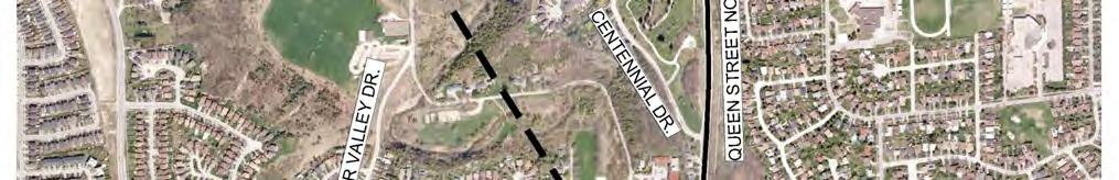


109 Figure 19 Preferred Feedermain Route 88
110 9. Phase 3: Alternative Designs to the Preferred Solution 9.1 Overview The Preferred Solution for the elevated tank site and the feedermain route comprises: A new 9.0 ML (2.38 MG) elevated storage tank located on the west side of Coleraine Drive near the existing elevated tank at Coleraine Drive (refer to Section 7.2 for the detailed evaluation of all sites investigated) A new 1050mm/600 mm/400 mm (42 /24 /16 ) diameter feedermain, approximately 5 km in length from the proposed elevated tank on Coleraine Drive through the Bolton Core with connection to the North Hill distribution system. 9.2 Description of the Preferred Elevated Tank Site Detailed site investigations were undertaken for the preferred elevated tank site to identify potential impacts and identify mitigation measures. The findings are presented in this section Natural Environment The identified natural features are presented in Figure 20 and summarized below. The Natural Environment Report is found in Appendix C Aquatic Habitat No aquatic features are present within the study area. There is however a small un-named warmwater watercourse is present to the south of the property. Historical TRCA fish occurrence records from approximately 8 km downstream of the site included historic records of Bluntnose and Fathead Minnows from 1946, also a single record of Blacknose Dace in The watercourse is managed for Darter Species downstream of Healey Road under the Humber River Fisheries Management Plan (MNR & TRCA, 2005) and is currently not identified as Redside Dace habitat nor is it considered under the Redside Dace recovery strategy. The project is not considered to directly or indirectly impact this watercourse, including its riparian forms and function Terrestrial The preferred tank and overflow pond location is contained within an existing paved parking lot and work yard of the property and has no existing vegetation Wildlife Habitat Wildlife habitat is considered to be of poor quality or non-existent due to the highly disturbed urban landscape and limited natural features of significant size or function. Species using the area are expected to be common to urban environments (i.e., squirrel, racoon, robin, sparrow, etc.) Socio-Economic Environment The property at Coleraine Drive abuts the Ritchie Brothers Auctioneers on the north and is zoned General Industrial (Caledon Official Plan 2008). The existing elevated tank is located across Coleraine Drive on the east side. To the south is an existing active agricultural field, currently zoned Prime Agricultural, however, the Town of Caledon is proposing to re-designate these lands to Employment Lands, and has already undertaken an Agricultural 89
111 Impact Study. There are ±2 single family dwellings within 100m which will have direct view of the elevated tank; however this line of sight will be buffered by future development. There are no other sensitive uses within m. 90

112 Feedermain Schedule C Class EA Study Figure 20 Natural Features 91
113 9.2.3 Archaeology and Built Heritage A detailed review of the potential elevated tank sites in the South Hill area occurred in 2010 by Archeoworks Inc. (Refer to Appendix B for Archeoworks Inc. report). Consultation of the Ontario Heritage Properties Database, as well as, the Town of Caledon s Database confirmed the presence of one (1) listed and three (3) designated heritage properties within 100 metres of the study area limits and one designated property, identified as the John Shore House within the limits of Coleraine Drive (Site No. 3). Background research has also determined that twenty-nine (29) archaeological sites have been registered within a 2000 metre radius of the study area of which twelve (12) are located within 250 metres of the study area limits. This would indicate that the potential for locating additional sites within this region is possible. In addition, the Humber River and its associated tributaries bisect the study area; therefore research supports high potential for locating Aboriginal artifactual remains within 300 metres of these water sources. A review of the study area within the 1859 Tremaine s Map of Peel County and 1877 Illustrated Historical Atlas of Peel County indicated that numerous historical features, including the historic village of Bolton, were formerly located within or in close proximity to the limits of the study area. As such, the background research also supports high potential for locating historical remains within undisturbed portions of its limits. With the exception of the proposed Coleraine Drive site, which was subject to previous Stage 1-2 assessment and was cleared of any further archaeological concerns, the sites comprising potential elevated tank sites in the South Hill area were subjected to a Stage 1 field review. The sites were considered to be highly disturbed due to residential subdivision development, light commercial land uses and on-going construction. As well, disturbances adjacent to most roadways included narrow gravel shoulders, paved shoulders and sidewalks, drainage ditches, landscaping, underground utilities and sloping embankment. Furthermore, physiographic factors affecting potential included sloping terrain and low-lying wet areas identified in select locations throughout the study area. Due to the disturbed and physiographic conditions of these areas, archaeological potential can be considered removed and as such these areas do not warrant systematic archaeological survey. Prior to the construction of the proposed feedermains within the permanent easement on property Coleraine Drive a Stage 2 Archaeological investigation will be required for previously undisturbed areas Geotechnical Investigation A geotechnical investigation was completed by Exp. Services Inc. (previously known as Trow Associates Inc.) in July 2011, to support all on site work required for the construction of the elevated tank. The complete Geotechnical Report is included in Appendix F. The information contained in the geotechnical report is based on the available subsurface and groundwater information and it is not intended to provide the basis for the detailed design of the elevated tank; therefore, additional investigations will be conducted prior to the detailed design stage of the project. A brief discussion of the main issues and recommendations stated in the geotechnical report is as follows: The investigation consisted of drilling a total of three (3) boreholes to 12.7 m depth, with BH1 instrumented with 50 mm a monitoring well Wet and caving conditions were noted in BH 1 & 2, where no free water was observed in BH3 The five-day groundwater level in BH1 was recorded at 3.5 m below grade The finding in BH1 and 2 within the proximity of the proposed tank structure indicated very stiff clayey silt till encountered at foundation level Footings or a raft foundation founded on the native very stiff clayey silt till at or below depth of about 2.0 m below existing grade may be designed for a factored SLS bearing value of up to 300 kpa and a factored ULS bearing value of up to 450 kpa, subject to review during construction 92
114 The total and differential settlements of well designed and constructed foundations placed as recommended in geotechnical report, are expected to be small and well within the normally tolerated limits of 25 mm and 20 mm, respectively The Class for the proposed Site is D as per Table A, Site Classification for Seismic Site Response OBC 2006 Visual examination of the recovered soil samples does not show any signs (i.e., staining, odours, etc.) which may indicate potential environmental problems The site is generally suitable for the construction of the proposed elevated tank. 9.3 Description of Preferred Feedermain Route Detailed site investigations were performed along the proposed route to determine potential impacts and identify mitigation measures are summarized in the following Sections Natural Environment The following sections provide a summary of ecological features within the feedermain segments and the elevated tank and reservoir location and the Natural Environment Report is included in Appendix C. The segments were divided as follows: Segment 1 - Coleraine Drive (Elevated tank Location to King Street West) Segment 2 King Street West (Coleraine Drive to Temperance) Segment 3 Temperance (King to Sterne) and Sterne Street Segment 4 Highway 50/Queen Street Humber River Crossing Segment 5 Highway 50/Queen Street Aquatic Segment 1- Coleraine Drive (Elevated tank location to King Street West) The Segment 1 feedermain route crosses an un-named watercourse at Coleraine Drive, approximately 210 m south of its intersection with King Street). The watercourse is a tributary to the West Humber River and originates from a stormwater management pond (SWMP) located to the west side of Coleraine Drive. It is classified as a warmwater system with an intermittent flow regime. The watercourse flows easterly as a small meandering channel passing through a semi-naturalized, narrow, steep valley corridor. For approximately 300 m, the watercourse channel runs parallel to King Street before entering a separate SWMP near the intersection of King and Station Road. From this point onward, flow from the SWM pond is directed below ground to the north across King Street to the Main Humber River. No TRCA or MNR fish occurrence records exist for this watercourse. Based on similar watercourses where such information is known, this watercourse is expected to be comprised of highly tolerant warmwater baitfish species. Specifically, this watercourse is managed for Darter species under the Humber River Fisheries Management Plan (HRFMP) (MNR & TRCA, 2005) and is currently not identified as Redside Dace habitat nor is it considered under the Redside Dace recovery strategy. Barriers in fish migration are not confirmed, but likely present at Coleraine Drive as well as at the crossing of King Street. Water quality is expected to be poor due to influence from upstream sources and surrounding land use. This includes oil, metals and hydrocarbons from road runoff. The available fish habitat within this warmwater watercourse is of low quality. 93
115 Segment 2 King Street West (Coleraine Drive to Temperance) The Segment 2 feedermain route crosses the same un-named watercourse. This watercourse is directed below ground to the north across the feedermain route (King Street), below a residential area ultimately discharging into the Main Humber River approximately 0.5 km to the north. Since the watercourse is buried at this crossing, it provides no direct habitat function, but likely provides some indirect contributions to the Main Humber. The watercourse upstream provides limited warmwater fish habitat and is of low quality. Fish community assemblage is expected to be highly tolerant. The watercourse is highly impacted by anthropogenic influences including moderate to high density urban land use upstream of the crossing location. Segment 3 Temperance (King to Sterne) and Sterne Street No aquatic features are present. Segment 4 Highway 50/Queen Street Humber River Crossing The principle aquatic feature within this segment is the Humber River. The proposed method for routing the water main within the vicinity of the Humber River is bridge suspension from a new crossing structure to be built adjacent to the existing bridge. Bridge suspension avoids potential adverse impacts to the watercourse associated with alternate construction methods such as any trenchless crossing or open cut construction. Moreover, bridge suspension takes advantage of existing infrastructure and right of way to minimize impacts to previously undisturbed lands. Mitigation for the protection of watercourses during overhead bridge construction is well documented by Fisheries and Oceans Canada ( and within current construction Best Management Practices (i.e. BMP) typically used for such projects. Minimizing the potential adverse impacts to the Humber is important because of the overall importance and sensitivity of the Humber River as fish habitat. The Main Humber River is a permanent coldwater system containing a sensitive sportfish community. The MNR manages this system for Brook trout (Salvelinus fontinalis), Brown trout (Salmo trutta) and Atlantic salmon (Salmo salar) under the Humber River Fisheries Management Plan (MNR & TRCA 2005). Currently the study area reach is not identified as Redside Dace habitat nor is it considered under the Redside Dace recovery strategy. Fish species occurrence records provided from TRCA characterizes the local fish community within the Main Humber River at the location of the feedermain crossing. These species are provided in Table 15 below. Table 15 Fish Species Occurrence Records for the Study Area Reach of the Main Humber River Common Name Scientific Name Common Name Scientific Name Common Shiner Notropis cornutus Longnose Dace Rhinichthys cataractae Blacknose Dace Rhinichthys atratulus Stonecat Noturus flavus Creek Chub Semolitus atromaculatus Rainbow Darter Etheostoma caeruleum Faintail Darter Etheostoma flabellare Johnny Darter Etheostoma nigrum Brown Trout Salmo trutta Pumpkinseed* Lepomis gibbosus White Sucker Catostomus commersonii American Brook Lamprey* Lampetra aepyptera Northern Hog Sucker Hypentelium nigricans Bluntnose Minnow* Pimephales notatus River Chub Nocomis micropogon Fathead Minnow* Pimephales promelas Note: *Historical presence (1970s, TRCA) The Main Humber River flows within a naturalized valley corridor that narrows considerably through the Town of Caledon. The River can be described as a wide and shallow watercourse. Substrates at the crossing consist of 94
116 fines, cobbles and boulders. It is unknown if spawning occurs within the vicinity of the crossing, but any potential impacts would be addressed through use of applicable construction timing window restrictions. Overall, the watercourse provides high quality coldwater fish habitat for sensitive coldwater species such as Brown Trout. Segment 5 Highway 50/Queen Street The Segment 5 feedermain route crosses an un-named watercourse on Highway 50/Queen Street, approximately 325 m south of the intersection with Columbia Way). The watercourse is a tributary to the West Humber River and is classified as a war water system with an intermittent flow regime. The un-named watercourse originates from a stormwater management pond (SWMP) located to the east side of Highway 50/Queen Street. To the west, the watercourse is characterized as a small meandering channel that flows through a naturalized corridor. It continues to flow in a southwesterly direction for approximately 625 m before entering the Main Humber River. The fish assemblage of this system is comprised of warm water tolerant species. Currently, this watercourse is managed for Darter species under the HRFMP (MNR & TRCA, 2005). Redside Dace habitat is not present within this reach and the system is not considered under the Redside Dace recovery strategy. Barriers in fish migration are not confirmed, but likely present at Highway 50/Queen Street with the presence of the SWMP. Water quality is expected to be poor due to influence from upstream source and surrounding land use. This includes oil, metals and hydrocarbons from road runoff as well as fertilizers and pesticides from local parkland Wildlife and Wildlife Habitat Segment 1- Coleraine Drive (Elevated Tank Location to King Street West) Wildlife habitat is considered to be of poor quality or non-existent due to the highly disturbed urban landscape and limited natural features of significant size or function. Species using the area are expected to be common to urban environments (i.e., squirrel, racoon, robin, sparrow, etc.). The presence of a stormwater pond on the west side of Coleraine Drive may provide additional amphibian habitat, but there is no migratory pathways from this location to adjacent areas. Segment 2 King Street West (Coleraine Drive to Temperance) Wildlife habitat is considered to be of poor quality or non-existent due to the highly disturbed urban landscape and limited natural features of significant size or function. Species using the area are expected to be common to urban environments (i.e., squirrel, racoon, robin, sparrow, etc.). The presence of a stormwater pond on the south side of King Street West may provide additional amphibian habitat, but there is no migratory pathways from this location to adjacent areas. Segment 3 Temperance (King to Sterne) and Sterne Street Wildlife habitat is considered to be of poor quality or non-existent due to the highly disturbed urban landscape and limited natural features of significant size or function. Species using the area are expected to be common to urban environments (i.e., squirrel, racoon, robin, sparrow, etc.). Segment 4 Highway 50/Queen Street Humber River Crossing Wildlife habitat is considered to be of poor quality or non-existent due to the highly disturbed urban landscape and limited natural features of significant size or function. Species using the area are expected to be common to urban 95
117 environments (i.e., squirrel, racoon, robin, sparrow, etc.). Although the area is largely urbanized with limited natural features along the alignment, there are areas of higher quality habitat. Specifically, the feedermain portion that borders this habitat is through the Humber River Valley (Figure 20). In this area, parts of, or most of the Valley to the northwest of Bolton are likely to be considered Significant Wildlife Habitat (SWH) based on several potential criteria listed in the Peel-Caledon Significant Woodlands and Significant Wildlife Habitat Study (North-South Environmental Inc. 2009). These include: Highly Diverse Areas, Habitat for Area-sensitive Forest Interior Breeding Bird Species, Raptor-nesting Habitat (Red-shouldered Hawk), Species Identified as Nationally Endangered or Threatened by COSEWIC which are not listed as Endangered or Threatened under Ontario s Endangered Species Act (e.g., Golden-winged Warbler (Vermivora chrysoptera) which has been recorded here), and animal movement corridors, and possibly others. Moreover, it is important to note that available habitat within the study area is very limited (narrow strip) and therefore species noted are unlikely to be present. Segment 5 Highway 50/Queen Street Wildlife habitat is considered to be of poor quality or non-existent due to the highly disturbed urban landscape and limited natural features of significant size or function. Species using the area are expected to be common to urban environments (i.e., squirrel, racoon, robin, sparrow, etc.) Terrestrial Environment Segment 1- Coleraine Drive (Elevated tank location to King Street West) There is no vegetation within the Segment 1 feedermain route occurring within the Coleraine Drive ROW. Adjacent vegetation is predominantly manicured grass and individual ornamental tree plantings along the ROW. Limited areas of cultural meadow, deciduous forest and coniferous plantation are present within a small semi-naturalized valley where the feedermain crosses an un-named watercourse south of King Street). Segment 2 King Street West (Coleraine Drive to Temperance) There is no vegetation within the Segment 2 feedermain route occurring within the King Street West ROW. Adjacent vegetation along the ROW is described below. Cultural meadow is the predominant vegetation community along on the north side of King Street between Coleraine Drive and Deer Valley Drive). As this area is periodically mowed vegetation is disturbed. At the northeast and northwest corners of King Street and Deer Valley Drive are small inclusions of plantings of White Spruce (Picea glauca) approximately 5 m tall. Immediately east of Coleraine Drive is a small deciduous forest community located along a small watercourse feature, although it will not be affected as located between this feature and the feedermain route is a developed area (mowed grass with building). Areas of cultural thicket are also present. Vegetation on the south side of King Street lies within a narrow creek valley that is semi-natural with successional vegetation. Vegetation communities include cultural meadow, cultural thicket, deciduous forest and coniferous plantation. Tree species in the valley include American Elm (Ulmus americana), Red Ash (Fraxinus pennsylvanica), Crack Willow (Salix X rubens) and European Buckthorn (Rhamnus catharticus). At the southeast corner of King Street and Deer Valley Drive there is a small cultural thicket on bottomland that consists largely of Crack Willow and Red Ash. Disturbance to this area should be avoided if possible, as it is likely an area with a higher groundwater table than surrounding areas. A stormwater pond surrounded by cultural meadow also occurs on the southwest side of the intersection at King and Station Road. A small area of cultural 96
118 thicket and mixed forest is also present between Station Road and Hesp Drive, although will not be affected as located between this feature and the feedermain route is urban residential development. The remainder of King Street moving east to Temperance Road is predominantly urban residential and therefore dominated by lawn and ornamental street trees. Some very mature Bur Oak (Quecus macrocarpa) and Sugar Maple (Acer saccharum) occur on the north side of King Street, just west of Temperance Street. There are ±9 trees of primary concern adjacent to the roadway, 200 m west of Temperance Street. Construction mitigation such as hoarding will be performed to ensure that impact to trees is minimal. In general, new trees will be planted along King Street between Coleraine Drive and Station Road once construction is complete. Segment 3 Temperance (King to Sterne) and Sterne Street There is no vegetation within the Segment 3 feedermain route occurring within the King Street West ROW). Adjacent vegetation along the ROW is limited to manicured grass and individual street trees. A small portion of deciduous forest is located within 120 m of the feedermain route at the end of Temperance Street. This forest is part of the Humber River Valley woodland systems and according to the Peel Region Official Plan (OP) this woodland is part of a larger designated core-greenland area. Construction activities and feedermain alignment are not anticipated to encroach on this woodland. Segment 4 Highway 50/Queen Street Humber River Crossing There is no vegetation present within the paved parking lot, located on the south side of the Main Humber River, west of Highway 50/Queen Street. Adjacent features include the Humber River and its valleylands; which are buffered by a narrow strip (approximately 20 m) of young riparian deciduous woodland dominated by non-native Manitoba Maple. According to the Peel Region Official Plan (OP) this woodland is part of a larger designated core-greenland area. The River and its valleyland, including these woodlands are located within the Humber River crossing section (i.e. pipe suspension of the feedermain route) which is not expected to create significant impact. Within the areas north of the river crossing up to Centennial Drive (north shaft location) on the west side of Highway 50/Queen Street, vegetation is limited to street trees and manicured lawn associated with residences along the alignment. A small portion of deciduous forest is located along Centennial Drive but will be unaffected by construction activities. On the east side of Highway 50/Queen Street and north of Warbrick Lane, there is a small deciduous forest containing Sugar Maple, White Ash and American Basswood. This forest is part of the Humber River Valley woodland systems and according to the Peel Region Official Plan (OP) this woodland is part of a larger designated core-greenland area. A narrow strip of cultural meadow with scattered White Ash and Sugar Maple saplings occurs along Highway 50/Queen Street between the forested area and the ROW. Segment 5 Highway 50/Queen Street There is no vegetation within the Segment 5 feedermain route occurring within the Highway 50/Queen Street ROW. Adjacent vegetation along the ROW is limited to manicured grass and individual trees with the exception to a small, poor quality deciduous forest located at the southern edge of the cemetery (west side of Highway 50/Queen Street, north of Centennial Drive, where trees are scattered throughout and the canopy is approximately 8 m from the sidewalk (which closely boarders the road). Cultural meadow is also located within areas adjacent to the ROW. 97


119 9.3.2 Social Environment Effects on land use associated with the feedermain route are short-term and moderate. Along open cut areas, particularly on King Street east of Deer Valley Drive, where houses have direct access to King Street, and along Temperance, Sterne, Ann and Highway 50, just north of the Humber River, access to private properties and public space will be compromised for a temporary period of time during construction. Nuisance effects such as noise, dust and vibration will have significant short-term impacts with Option C. Within 100 m there are ±174 residential dwellings, ±32 commercial properties, 1 police station. 1 fire hall, ±2 banks, and several properties that will be particularly affected by nuisance effects: 1 paramedic service, 1 community service, and 1 nursing home. As Option C will be installed through the Bolton Core area, there will be significant short term disruptions to transportation due to temporary road closures, detours, and travel delays as well as temporary loss of sidewalks. The most considerable impact may be to the fire hall and paramedic services on Temperance, and on the police station on the east side of Queen Street. Also, there will be considerable impact felt on King Street east of Deer Valley Road, where houses have direct access to King Street, and along Temperance, Sterne, Ann and Highway 50, just north of the Humber River. The aesthetic impacts for Option C are considered to be significant but short-term. There are ±58 dwellings along King, Temperance, Sterne and Ann, and ±6 dwellings along Highway 50 that do not have a buffer. Although impacts associated with Option C will be significant, they will be short-term and community enhancement post-construction, through coordination with the Town of Caledon, will be permanent. Parking lot and parkette improvements will be coordinated with the Town of Caledon s long-term plans. New sidewalks and curbs along Temperance and Sterne Streets will be constructed, as well as new storm sewers and re-paving of the Bolton Core area streets, where construction will occur. View looking east on Sterne Street Conceptual sidewalk on north side of Sterne Street 98

120 On the north side of the Humber River, sidewalk improvements will occur along Highway 50/Queen Street, on the west side of Highway 50 from Hickman Street to Bolton Heights Drive and on the east side of Highway 50 from Bolton Heights Drive to Columbia Way. This new sidewalk will link downtown Bolton to Bolton Heights and Columbia Way and will provide access between the Albion-Bolton District Park and the Caledon Centre for Recreation and Wellness. Queen Street/Highway 50 and Bolton Heights Drive, Bolton Since the construction of the feedermain will cause some traffic impacts on King Street and other routes, it is recommended that the Region of Peel follows the MOE Noise guideline NPC-206 (Sound levels due to Road Traffic MOE, October 1995). Furthermore, it is recommended that during construction, approved non-chloride dust suppressants are used, and that the Region of Peel ensures that proper equipment maintenance is kept to minimize NOx and VOC emissions Archaeology and Heritage Features The preliminary preferred feedermain alignment was reviewed as part of this assignment by Archeoworks Inc. with the understanding that trenchless crossing methods are proposed for the crossing of the Humber River at Highway 50. At the time that borehole investigations were occurring in the parking lot area a sample of the borehole material extracted was examined by Archeoworks Inc. to determine archaeological potential on the area south of Humber River for proposed shaft for trenchless crossing of the Humber River and the material did not yield anything that would indicate archaeological potential, therefore the proposed shaft location on the south side of the Humber River is considered clear of further archaeological concerns. A shaft location was originally located on the north side for the trenchless crossing of the Humber River, within the sloping embankment along the east side of the Queen Street North. While the immediate embankment is classified as low in archaeological potential, located at the top of the hill is the Albion Congregational Church Burying Ground. Stage 3 archaeological investigations immediately north of Warbrick Lane, on the east side of Highway 50 were undertaken on November 19 th, Burial remains, including human bone and nails were found at the northern edge of the proposed tunnel shaft and were encountered immediately underneath the overlying grass and roots and appeared to have been partially removed by the previous construction work. When the bones were exposed and inspected, work at the site was halted and the local Police and Coroner were immediately contacted to confirm that the site had no forensic interest and as such was released back to Archeoworks. A letter-report was submitted to the Cemeteries Regulation Section of the Ministry of Government Services and is found in Appendix B. Given the findings and due to other issues related to the alignment on that side of the road, the feedermain alignment was reconfigured to the west side of Highway 50 within the road right-of-way. With respect to the archaeological potential for the area within the downtown Bolton parking lot, a review of numerous easement properties in this area indicated that the proposed feedermain route has been disturbed by 99
121 existing parking lot construction or previous installation of water/sewer facilities. Therefore, no archaeological investigation is required for the feedermain alignment within the Bolton Core parking lot area Geotechnical Investigation Phase I A geotechnical investigation was undertaken to obtain information about the subsurface soil and groundwater conditions along the preferred feedermain route and to make recommendations based on the findings, for the design and construction of the preferred feedermain. The complete Geotechnical Report is included in Appendix F. The information contained in the geotechnical report is based on the available subsurface and groundwater information and it is not intended to provide the basis for the detailed design of the feedermain; therefore, additional investigations will be conducted prior to the detailed design stage of the project. A brief discussion of the main issues and recommendations stated in the geotechnical report is as follows: The north and south ends of the feedermain route will be installed by open cut trench in Fill overlaying silty clay till or clayey silt till The middle portion of the feedermain route, i.e., with the Bolton core will be installed by open cut trench in Fill overlaying wet, dilatants silt, sandy silt and clayey silt The results of the organic parameter test indicated fraction of Petroleum Hydrocarbons in western limits of the Bolton Core parking lot. it is suggested that a Follow-up Petroleum Impacted Soil Investigation to be carried out during detail design stage of this project Most of the soil types encountered in the boreholes provide good support to the proposed feedermains. In wet trench conditions Clear Stone or High Performance Bedding completely wrapped with a non-woven filter fabric to be used as pipe bedding Open-cut installation of the feedermain in Bolton core, approximately within the TRCA regulation limits may require temporary dewatering. The method of temporary dewatering will be selected during detail design stage of the project A Permit-To-Take-Water from the MOE may still be required depending on the amount of dewatering required. It is further noted, that the feedermain, once constructed, is not anticipated to have any significant long-term impact on local groundwater flow. The proposed 1050 mm diameter feedermain will cross CP Railway tracks on Coleraine Drive via tunnelling. Tunnelling can be either hand mining within a shield with forward hood, or a tunnel boring machine (TBM). Detailed design drawings will be submitted to CP Railway for review and approval during detail design construction stage The proposed 400 mm diameter feedermain will cross the Humber River along Hwy-50 via. If trenchless underground feedermain installation is selected, the report recommends the use of Horizontal Directional Drilling (HDD) method. Silt, Sandy silt, and Clayey silt were encountered in the boreholes along this trenchless crossing. Piezometric level measurements were taken on two occasions following completion of the drilling. Appropriate measures will be undertaken to install and support the feedermain in wet areas or areas of incompetent soil conditions Geotechnical Investigation Phase II A Phase II Geotechnical Investigation was undertaken to complete a Follow-up Environmental investigation of a portion of the feedermain alignment crossing Bolton Core parking lot. The work program for this investigation was developed based on the findings contained in Phase I Geotechnical investigation discussed above. This Follow-up Environmental Investigation Report is included in Appendix F. 100
122 The Phase I investigation indicated that Petroleum Hydrocarbons (PHCs) at concentrations exceeding applicable Ministry of Environment Standards were detected in soil at one test location. Follow-up investigation was required to determine the extent of the feedermain alignment affected by the presence of petroleum impacted soils. An Electromagnetic Scan of the parking lot through which the feedermain is scheduled to pass was also to be carried out to check for the presence of underground storage tanks (USTs) in the area. The objective of this Follow-up Environmental investigation was to assess the subsurface soil condition of the Site. The work was carried out to meet the requirements of the current CSA Standard Z769-00, Phase II Environmental Site Assessment. Based on the findings of this Follow-up Environmental investigation and Phase I - Geotechnical Investigation, the following conclusions and recommendations are provided: The subsurface electromagnetic scan identified no underground storage tanks (USTs) within the boundaries of the portion of the parking lot scanned and included as the site for this investigation Petroleum impacted soil along the proposed feedermain alignment extends along the western limits of the parking lot Soil exhibiting exceedances of the selected MOE Table 2 Standards for Inorganic parameters was identified at approximately 0.7 to 1.2 m below grade detailed in the Follow-up Environmental Investigation Report Construction Procedures should include a health and safety plan to address issues related to petroleum impacted soil The specifications for the watermain pipe in the vicinity of the petroleum impacted soil should be checked for compatibility which such conditions Hydrogeology The hydrogeological assessment included a review of the MOE Water Well Records, a review of the physiography, geology and hydrogeology of the preferred feedermain alignment, as well as a site inspection to observe local groundwater characteristics. The Hydrogeology Report is included in Appendix E. A brief discussion of the main issues and recommendations stated in the Hydrogeological report is as follows: The Bolton area is located in the physiographic region known as the South Slope, which is characterized by undulating tracts of land faintly drumlinized Approximately 22 wells were identified within 500 m of the preferred feedermain alignment. All the wells within the 500 m of the preferred feedermain alignment draw water from overburden aquifers. The groundwater elevations along the proposed feedermain route varied from approximately 0.76 m to mbgs. The static water level (SWL) monitoring of the existing monitoring wells suggests that the most part of the feedermain is at or above the SWL. Due to the complex nature of geomorphology of the area, the shallow groundwater flow pattern is expected to be relatively complex The horizontal hydraulic conductivity of the overburden in the area close to the Humber River varies from 1.84 x 10⁻⁷ to 5.9 x 10⁻⁷ m/s Approximately 22 of the wells are located within 500 m of the proposed feedermain alignment. All the wells within 500 m of the feedermain alignment are screened in overburden aquifers The maximum predicted zone of influence to lower and maintain the groundwater level to a depth 0.5 m below the invert elevation of the feedermain is 9 m from the dewatering area The predicted zone of influence to drop and maintain the groundwater level below 8.0 m to 12 m below the SWL is in the range of 14 m to 28 m The estimated seepage rate for the open cut section of the feedermain is 66.3 m 3 /day. This dewatering rate was estimated for the full length of the open cut excavations extend into the saturated zone 101
123 There are no potential impacts of the dewatering activities at the site on the existing residential water wells Conduct a residential well monitoring program for the wells located within 500 m of the feedermain alignment Town of Caledon Work The Town of Caledon is undertaking plans for the long term revitalization of the Bolton Core area including reconstruction of the south west Bolton Core parking lot, reconstruction of Ann Street and the construction of a parkette adjacent to the Humber River. Town of Caledon and Region of Peel have met to discuss coordination efforts between Region s initiative and the Town s upgrades to the downtown in order to reduce impacts to the community construction. Meeting minutes are included in Appendix A. 9.4 Watercourse Crossings The proposed Feedermain route traverses many watercourses. Most of the water crossings are technically straightforward and have minimal environmental impacts. The pipelines will cross 6 identified watercourses as detailed in Table 20 below. The following watercourse crossing methods were considered for watercourse crossing under this project: Open cut Isolation Trenchless. Open Trench Occurs without any isolation or diversion of flow away from the work area Streams that cannot be crossed using the other methods may be crossed this way Any stream that is dry or frozen to the bottom can be crossed with this method. Isolation The work area is isolated from the flow of the stream and the pipeline is installed in dry conditions. Pipelines are installed by applying isolated (dry) crossing technique (i.e. dam and pump) to minimize the effects of instream construction during feedermain crossing installation. Trenchless Includes horizontal directional drill, bore microtunnel and aerial (above ground) options Construction of the crossing and installation of the pipeline has little impact on the stream itself Streams that have high flows during construction and/or high fisheries sensitivity may be crossed this way. Determining the most suitable watercourse crossing method requires consideration of a number of factors such as: Fish and fish habitat Geotechnical issues - including Horizontal Directional Drilling (HDD) feasibility, the stability of the valley slopes and the risk of debris flow Hydro-technical issues such as flow volumes and channel stability Construction issues - including complexity, risk, safety, schedule and cost Regulator, resource managers, Aboriginal group, community and stakeholder input Temporary and permanent access requirements Pipeline operational and pipeline integrity issues Reliability, robustness, cost and maintenance issues over the life of the pipelines Wildlife habitat, such as migration routes for animals and nesting areas for birds Aboriginal Traditional use. 102
124 During the project planning phase, discussions regarding watercourse crossings were conducted with TRCA. As per TRCA requirements, 2.0 m clearance will be provided between the invert of the watercourse and obvert of the proposed feedermain. The following Table 16 provides the list of watercourses identified along the Feedermain alignment, and its crossing methodologies: Table 16 Watercourse Crossings Methodology Watercourse Location Permanent Easements on Coleraine Drive (South of new Elevated Tank Site) Coleraine Drive, 100 m south of Harvest Moon Drive King Street West, 50 m west of Jane Street Crossing Methodology Isolated (dry) crossing technique (i.e., dam and pump) Open-cut Isolated (dry) crossing technique (i.e., dam and pump) Hwy-50, Humber River Aerial - Feedermain will be suspended along a new bridge structure 72 m south of Columbia Way Isolated (dry) crossing technique (i.e., dam and pump) 312 m south of Columbia Way Isolated (dry) crossing technique (i.e., dam and pump) 9.5 Humber River Crossings Alternatives An assessment of feasible construction methods for the proposed feedermain crossing of the Humber River was undertaken as part of this process. The crossing alternatives included pipe suspension and trenchless (HDD) method. The two methods are briefly described below and are evaluated in Table Pipe Suspension The methodology of pipe suspension provides a means of crossing the Humber River without tunnelling underneath the feature and requiring major installation shafts. Pipe suspension can be accommodated by either structurally attaching the pipe to either a new or existing structure. In the case of the Humber River crossing in the Bolton Core, there is an existing Humber River bridge that could be considered for structural suspension. Alternatively, a new structure, immediately adjacent to the Humber River bridge could be considered. The pipe would be installed to rise out of the ground and be exposed/attached to the structure. The exposed pipe would be insulated and protected Horizontal Directional Drilling Directional drilling is a trenchless technology that mitigates damage to sensitive environmental features by drilling underneath potential sensitive areas, such as the Humber River and pulling the feedermain through the bore created. The proposed crossing of the Humber River would be through the use of the HDD. The results of the Geotechnical investigations undertaken for this study have confirmed that the trenchless is technically feasible provided appropriate construction mitigation measures are utilized. Construction activity above ground is minimal as compared to open cut construction. 103
125 Table 17 Evaluation of Humber River Crossing Methodologies Trenchless (HDD) Method Property acquisition will be required (working and permanent easements from different property owners) Large staging area required within the Bolton core parking lot Longer duration of disruption -approximately 3 months Deep shaft required on south side of the Humber River More impact to businesses in the Bolton core parking lot Extensive de-watering at shaft locations No impact to residences on west side of Highway 50/Queen Street between Hickman St. and Centennial Drive No Traffic impact between Hickman St. and southern end of Centennial Drive Not Preferred Pipe Suspension Minor property acquisition (working easements may be required during construction) for new structure (for pipe suspension) No staging area within the parking lot Longer duration of disruption -approximately 3 months No shafts required Reduced impact on businesses in Bolton core Reduced dewatering due to shallow construction Minor impact to residences on west side of Highway 50/Queen Street between Hickman St. and Centennial Drive Traffic will be impacted between Hickman St. and southern end of Centennial Drive Preferred The preferred method of crossing the Humber River bridge is the suspension of the feedermain pipe. The preferred suspension crossing methodology will be finalized during detail design. It is anticipated that the concept involving a new structure adjacent to the existing bridge on the west side is preferred as detailed in Drawing No. 12 in Appendix H of this report. This type of installation would allow for the independent servicing of both structures and would not interrupt delivery of water services during future rehabilitation or removal of the existing bridge. It would also allow for potential sidewalk expansion on the west side of the bridge. The new structure would have minimal environmental impact as the design would include: Helical pile foundation behind the bridge wingwalls Concrete cap and wingwall Two steel girders connected by spaced channel, on which the water main will sit There is opportunity to mask / cover the water main, if desired. The design and permanent location of the new structure will be further refined during detail design and in consultation with the Toronto and Region Conservation Authority. 104
126 10. Impacts and Mitigation Measures Based on the results of the elevated tank and feedermain evaluations, the North Bolton elevated tank and feedermain project may result in some negative impacts that are considered manageable with the appropriate mitigation techniques. The impacts and mitigation measures for both the elevated tank and the feedermains are discussed in the sections below. Such impacts will generally be limited to temporary impacts associated with construction activities of the feedermain and elevated tank Elevated Tank Site Construction Related Impacts The impacts associated with the proposed elevated tank site are generally related to its construction; these will be short-term and minor. By incorporating proper and best management practises and construction controls, these impacts can be minimized. Anticipated and/or potential construction related impacts and their associated mitigative measures are described in the following sections and summarized in Table Archaeology and Heritage Resources The proposed elevated tank site was subjected to a Stage 1-2 Archaeological Assessment by Archeoworks in November of The assessment resulted in the discovery of an isolated Late Archaic projectile point. Given the isolated nature of the find, no further archaeological concerns were warranted and the subject lands at Coleraine Drive were cleared of any further archaeological concerns Surface Water Mitigation measures recommended to minimize risk associated with potential impacts to the aquatic environment during construction include the implementation of standard BMPs, as described in the following subsections. Sitespecific mitigation measures will be identified during the detailed design phase. A specific contingency plan should be developed in the event that the overflow reservoir tops over and discharges uncontrolled water into the downstream unnamed watercourse. This would include sediment and erosion controls and water quality mitigative measures Groundwater Control During excavation for the construction of the elevated tank some seepage of free water from fill or more pervious seams and layers within the native soil is anticipated. Temporary pumps should be used to control and remove any such seepage. Further, all excavation will be carried out in accordance with the most recent Occupational Health and Safety Act. The construction contract will specify that all dewatered volumes be settled before discharging into the environment Aesthetic Impacts The new elevated tank to be located at Coleraine Drive will create minimal impacts in terms of visibility and shadows. The preferred location was selected to mitigate impacts to the surrounding community to the largest extent possible and results in a net positive impact considering the following: Location is the extreme southwest corner of the community, as opposed to residential or potentially intrusive areas Location is not considered a community gateway Location is in the vicinity of the existing water tower and its function is in line with approved land uses, according to the Town of Caledon Official Plan. 105
127 Air Quality Material handling, such as excavation, loading and hauling will be the most significant source of dust during construction of the elevated tank. Dust control will be achieved through planning and proper implementation of construction controls and mitigation which include, but are not limited to, use of dust suppression measures such as spraying down the site and roadways, limiting excavation on windy days, washing trucks on a regular basis and use of dust covers on haulage trucks. The construction contract will specify the need for street sweeping and the use of mud scraping. Construction activities associated with the elevated tank are not expected to create quantities of dust that will exceed acceptable MOE guidelines; appropriate mitigation measures will be implemented during construction to reduce localized dust emissions around the site. To prevent air quality impacts associated with construction vehicle exhaust fumes, emission control devices on equipment should be functional and effective. Further, new or well maintained heavy equipment and machinery, preferably fitted with muffler/exhaust system baffles as well as the use of engine covers should be used Noise There is potential for short-term construction related noise impacts to occur in the immediate vicinity of the elevated tank site, although sound levels are expected to be well below MOE Sound Level Limits. Construction activities will be restricted to hours prescribed by the Town of Caledon noise by-law. Further, the construction contract will specify the use of hoarding around the site. Ensuring that equipment is in sound working order and using noise attenuation devices (i.e. mufflers on motorized equipment) will ensure compliance with government requirements and will result in sound levels being within acceptable levels both on and off-site. Although these recommended mitigation measures will be effective at minimizing the likely environmental effects due to construction related noise, minimal residual localized effects may result, particularly for those buildings in very close proximity to the elevated tank site Traffic There will be occasional disruptions to traffic in the vicinity of Coleraine Drive and King Street during construction of the elevated tank. Where this may occur, disruptions should be restricted to off-peak hours, advanced notification should be provided, in addition to the use of signage to direct motorists Utilities Construction schedules will be coordinated with the local hydro utility company and similarly, with other municipal services and utilities to ensure any disturbance to service is minimal Post Construction Impacts The normal operation of an elevated tank is relatively benign. The tower itself releases no air emissions and there is no equipment to create noise disturbances such as diesel generators; nor are there any moving parts. Region of Peel (Water Quality Public Works) Staff will require access to the elevated tank site approximately 3 times a week (Monday, Wednesday and Friday) to sample and measure chlorine residual. The duration of these activities may be approximately minutes. Staff would access the site in a clearly marked regional truck and/or provide identification, if requested. 106
128 Regular maintenance of the elevated tank would likely occur twice per year to address mechanical and/or electrical equipment however, access may be required at any time for an unlimited duration of time. Every 7-12 years, the Region will need to apply fresh paint to the tank in order to maintain aesthetic appeal. This process takes approximately 2 months to complete and would require a tank and painting equipment to be stored on-site. Region of Peel Health and Safety, as well as Ministry of Environment, measures would be applied and adhered to at all times during the painting process. Table 18 Potential Construction Related Impacts and Associated Mitigation for the Elevated Tank Potential Impacts Aquatic Resources Groundwater Surface Water Socio-Economic Air Quality Noise Traffic Technical Utilities Proposed Mitigation Temporary pumps should be used to control and remove any water seepage during excavation. All excavation will be carried out in accordance with the most recent Occupational Health and Safety Act. Contingency plan should be developed in the event that the overflow reservoir tops over and discharges uncontrolled water into the downstream unnamed watercourse. This would include sediment and erosion controls and water quality mitigative measures. The construction contract will specify that all dewatered volumes be settled before discharging into the environment. Use of dust suppression measures such as spraying down the site and roadways, limiting excavation on windy days, washing trucks on a regular basis and use of dust covers on haulage trucks. Emission control devices installed on construction on equipment and vehicles should be functional and effective. New or well maintained heavy equipment and machinery, preferably fitted with muffler/exhaust system baffles as well as the use of engine covers should be used. Construction activities will be restricted to hours prescribed by the Town of Caledon noise by-law. Hoarding around the site. Ensure that equipment is in sound working order and use of noise attenuation devices (i.e. mufflers on motorized equipment) to ensure compliance with government requirements. Traffic disruptions should be restricted to off-peak hours Advanced notification should be provided, in addition to the use of signage to direct motorists. Construction schedules will be coordinated with the local hydro utility company and similarly, with other municipal services and utilities 10.2 Feedermain Route Construction Related Impacts Impacts related to the proposed feedermain will be limited to the period of its construction and during periodic future maintenance. With the appropriate measures, these impacts can be minimized. The potential construction impacts and the appropriate mitigation are discussed in Sections below and are summarized in Table Traffic Traffic flow will be affected throughout the duration of the project due to the installation of the feedermain and the large amount of material and equipment that will be transported to the site. There are three locations where open-cut installation of the feedermain within the road corridor will temporarily impact local traffic. The first location is along the north side of King Street West from Colerain Drive to Hesp Drive and on the south side from Hesp Drive to Temperance Street; the second location is within the Bolton Core parking lot and the third location is along west side of Queen Street/Highway
129 The traffic plan for these roadway work zones will consider worker and motorist safety, motorist mobility, advance warnings, work site identification and positive guidance. The Ontario Traffic Manual (OTM) Book 7 and the Field Edition address the application of control devices in temporary construction, maintenance and utility work zone. For all stages of construction, delineators will be used to separate the vehicle traffic from the work zone. In addition, the speed limit will be reduced within the construction zone for the duration of the project. All night-time road closures and extended daytime delays will require one-week advanced public notification. All construction activities shall comply with the local noise by-law. Emergency vehicles will be allowed access through the construction site at all times. King Street West King Street west is a 6.0m wide local road with two way traffic and parking lane on the south side. Traffic impacts vary depending on each stage. During the installation of the feeder main, 100m to 200m portions of the existing pavement on the north side of King Street West from Colerain Drive to Hesp Drive and on the south side from Hesp Drive to Temperance Street will be excavated and will be inaccessible to public. The contractor will protect the work zone from local traffic and, where practicable, workers will be positioned at least 3.0m from a live traffic lane (1.5m for low speed). A minimum of one 3.0m wide traffic lane should be maintained for traffic. When necessary, temporary detours and temporary lane closure of one direction of traffic will be maintained with appropriate use of traffic control devices, in accordance to OTM Book 7. The pedestrian sidewalk along King Street and access to intersecting roadways will be maintained during construction. All business and residential access will be maintained at all times. Bolton Core Parking Lot The Bolton Core Parking lot serves as the main parking lot for many business establishments in the area. During construction, portions of the parking lot, generally by the south-west corner, will be fenced off as staging area for the drilling and construction vehicles will continuously access the site. The contractor will minimize the number of parking spots taken for the staging area and will locate the access gate to provide safe movements for construction vehicles and patrons. Safe access to the remaining open parking spaces will be maintained at all times during construction and the contractor shall arrange proper parking locations for the crew and the construction vehicles outside the parking lot. Adequate pedestrian access route to the parking lots from local business will also be maintained. Any utilities located around the construction area will be protected and will remain accessible to utility owners. During the construction of the drain chamber south of Humber River, the entrance from Queen Street to the parking lot will be temporarily closed to public. Some parking access will be provided to the management of Black Bull Pub. Pedestrian access to buildings will be maintained at all times through Timothy Street. All temporary conditions will be in accordance with OTM Book 7. Queen Street North / Highway 50 Queen Street North / Highway 50 is a 3-lane major arterial, with 2 northbound lanes and 1 southbound lane. The proposed exit shaft/pit of the trenchless drilling will exit north of Centennial Drive and Queen Street intersection, and will be closed to traffic. One lane of Centennial Drive to remain open at all times to traffic. The proposed open-cut feeder main installation will be within the west boulevard. The contractor shall protect the work zone from local traffic and, where practicable, workers shall be positioned at least 3.0m from live traffic lane 108
130 (1.5m for low speed). When necessary, some portion of the southbound lane will be used as construction zone to lay down the pipe prior to installation. This will require partial traffic lanes shifting to the east in accordance to OTM Book 7. Two northbound lanes and one southbound lane with a minimum width of 3.0m per lane will be maintained at all times during construction. Pedestrians will be directed to use the east side of Queen Street/Highway 50 during construction Public Notification Public notification will occur in advance of construction to ensure that users of the proposed feedermain route and parking lot area are informed. Adjacent businesses, residents, the King Nursing Home and community services (i.e. Town of Caledon Fire and Emergency Services, Dufferin-Peel and Peel School boards, GO Transit etc.) will be notified directly of impending works Archaeology and Heritage Resources Upon completion of the final design of the proposed feedermain alignment, all undisturbed sections falling within these designs, to be impacted by construction activities, should be subjected to a Stage 2 archaeological field assessment n order to minimize impacts to heritage resources. Should significant archaeological resources be encountered additional background research or fieldwork may be required by the Ministry of Tourism and Culture Noise and Dust Control There will be temporary impact on the residential areas during the installation of the feedermain. Noise disturbance will be limited by ensuring that construction takes place during normal working hours. Material handling, such as excavation, loading and hauling, is the most significant sources of dust during construction. However, dust control during construction can be easily achieved through planning and proper implementation of construction practises and mitigation measures which may include spraying down the site and roadways, limiting excavation on windy days, washing of trucks and use of dust covers on haulage trucks. The construction activities required are not expected to create quantities of dust that will exceed acceptable Ministry of the Environment Guidelines. However, while the appropriate measures will be implemented during construction, there may be localized residual dust emissions around the construction site. To prevent air quality impacts associated with construction vehicle exhaust fumes, emission control devices on equipment should be functional and effective and new or well-maintained heavy equipment and machinery, preferably fitted with muffler/exhaust system baffles and engine covers should be used. Dust will be controlled through construction contract obligations Re-Use/Disposal of Excavated Materials Apart from the organic alluvial deposits, it should be feasible to reuse most of the excavated native material for backfilling. The silt, sandy silt and clayey silt could be too wet for good compaction, in which case these materials should be partially dried prior to re-use. Fill materials containing topsoil or a high proportion of organic matter, should not be re-used. Based on the results of a limited number of chemical tests, excavated materials from the vicinity of Borehole 6A are considered environmentally unsuitable for re-use on-site. The lateral extent of the unsuitable materials should be confirmed by further investigation and testing at the detailed design stage. 109
131 Backfill Compaction Under roads, walkways and other areas where long term ground settlement is not acceptable, the backfill material should be placed in 300 mm lifts and compacted according to industry standards. Where trench boxes are used for temporary support, the trenched above the pipe zone should be backfilled with non shrink grout if long term settlement is not acceptable Vegetation and Vegetation Communities Erosion and Sediment Control Mitigation measures must be used for erosion and sediment control to prohibit sediment from entering adjacent vegetation communities. The primary principles associated with sedimentation and erosion protection measures are to: (1) minimize the duration of soil exposure, (2) retain existing vegetation, where feasible, (3) encourage revegetation, (4) divert runoff away from exposed soils, (5) keep runoff velocities low, and (6) trap sediment as close to the source as possible. To address these principles, the following mitigation measures are proposed: According to Ontario Provincial Standard Specifications, silt fencing (OPSD ) is required along all construction areas. All surfaces susceptible to erosion should be re-vegetated through the placement of native seeding, upon completion of construction activities. Dogwood (Cornus sp.), alder (Alnus sp.) and willow (Salix sp.) in order to stabilize expose or disturbed soils. These measures should be incorporated into the initial detailed design drawings and contract specifications. Tree Removal Tree removal limits should be clearly delineated with high visibility fencing or marking. Install tree protection fencing and establish buffer setbacks in consultation with a TRCA or qualified biologist prior to any tree removal or start-up of construction. A tree removal or Protection Plan will be required as part of the application, trees identified for protection should be hoarded as directed by By-law or qualified professionals. Breeding Birds Vegetation clearing should be completed within an allotted time period as to not interfere with breeding bird activity and shall adhere to the Migratory Birds Convention Act. Breeding generally occurs in southern Ontario between May 1 and July 31 but may differ at the site level. Clearing outside of this timing window is acceptable. For vegetation clearing in small areas between May 1 and July 31 a qualified ecologist must survey the area for breeding bird activity and advise whether vegetation clearing may proceed at that time. Construction activities should be limited to a period after 7:00 a.m. and before 7:00 p.m. daily. Also, construction during early spring bird breeding should be avoided. Reasons to avoid the bird nesting period are due to the need to not interfere with territory selection, mate selection, nest construction, egg-laying, and nestling to fledgling periods. Depending on the timing of construction, netting to prevent nest establishment may be required for areas under the existing bridge structure. 110
132 Aquatic Habitat and Communities Mitigation measures recommended to minimize risk associated with potential impacts to the aquatic environment during construction include the implementation of standard BMPs, as described in the following subsections. Sitespecific mitigation measures will be identified during the detailed design phase. A specific contingency plan should be developed in the event that the overflow reservoir tops over and discharges uncontrolled water into the downstream unnamed watercourse. This would include sediment and erosion controls and water quality mitigative measures. Although appropriate mitigation measures will be employed, there is always potential that construction activity may result in loss of fish habitat. If this occurs, adequate compensation will be required. Timing of Works All in-stream construction activities must adhere to watercourse specific timing windows set by the MNR as to avoid critical spawning/migration periods. In general, construction activities near water or in-water should take place within the low flow period in the late summer months as to avoid or minimize impacts. In the case of rain events (20 mm in 24 hours) and significant snow melts, construction should be prepared to temporarily stop until soils stabilize as to not exacerbate erosion and the potential for sediment releases into nearby watercourses. A Flood Response Plan should also be developed to deal with on-site flooding as to mitigate any possible effects to the aquatic environment. Erosion and Sediment Control To minimize the potential for construction related sediment release into nearby watercourses a comprehensive erosion and sediment control (ESC) plan will be developed. The ESC plan will minimize sediment and erosion impacts to stream through the incorporation of specific elements as per the Erosion and Sediment Control Guideline for Urban Construction, December 2006 (ESC Guideline), prepared by the Greater Golden Horseshoe Area Conservation Authorities (GGHACA). This also includes the development and implementation of a site specific ESC Plan prior to the commencement of construction. The goal of the ESC plan is to preserve and protect the aquatic resources and other natural features of identified environmentally-sensitive sites affected by the construction. On all sites, multiple layers of protection are to be employed prior to the commencement of construction along with a regulated process for monitoring and maintenance to ensure that the measures are functioning within approved limits. Where ESC measures are found to be in an unacceptable condition they are to be repaired or replaced immediately Dewatering Limited dewatering is anticipated for the construction of the feedermain although may require a Permit to Take Water (PTTW) from the Ministry of the Environment (MOE). Anticipated discharge rates and estimated ZOIs should be evaluated in relation to the associated watercourse(s) to ensure the volumes will not impact steam corridor function or baseflow. Typical dewatering mitigation is discussed for the following impacts: Water quality Stream temperature Stream erosion and sedimentation Stream baseflow loss. 111
133 Water Quality To mitigate potential effects associated with the discharge, water quality samples must be obtained prior to discharge to ensure the quality is suitable for discharge and will not result in an impact to the receiving watercourse. If the groundwater is not suitable for discharge, alternate locations of disposal must be considered or adequate treatment must be carried out. At a minimum, groundwater is to be passed through a sediment filtration system prior to being discharged to a watercourse. The success of all mitigation will be verified though groundwater quality sampling. Temperature Thermal mass balance calculations should be completed prior to discharging to a watercourse to ensure the discharge will not result in an impact to the fish community. To mitigate for potential changes to stream temperatures groundwater discharge should be staged at the time of dewatering onset by incrementally increasing discharge to each location to avoid a single large pulse of coolwater, this approach will reduce the initial impact of the thermal response and pose a smaller risk to fish a sudden change in stream temperature. To further mitigate potential thermal changes groundwater discharge can be split to two or more discharge locations. It may also be possible to direct some or all of the groundwater discharge to a sanitary sewer system or a holding tank/pond, further reducing or eliminating any potential impacts on stream temperature. Erosion and Sedimentation Erosion thresholds should be determined by a fluvial geomorphologist prior to discharging to any watercourse. This will ensure the proposed discharge rate is ecologically appropriate as to not cause erosion or damage to fish habitat to the receiving watercourse. Depending on rates and erosion thresholds, discharge may be required to be split to more than one location in the watercourse. Flow dissipaters (i.e., sand bags, hay bales, etc) should also be installed at the location of discharge(s) to mitigate potential for erosion. Baseflow Although adverse impacts to baseflow are expected to be minor, the discharge of groundwater upstream of the ZOI will nonetheless act to provide additional mitigation to the potential loss of baseflow. A Baseflow Loss Response Plan must be developed where a watercourse is located within a ZOI. Site stream levels must be monitored to determine if dewatering activities resulted in baseflow loss dropping within 10% of low baseflow (measured as a water level in watercourse). If this level is reached, the Baseflow Loss Response Plan must be initiated and include the supplementation of stream flow with water of a quality appropriate for discharge. In general, stream flow shall be maintained for fish passage throughout the entire duration of work Surface Water Dewatering Limited surface dewatering is anticipated for construction. Since these areas will be isolated (i.e., coffer dams) surface dewatering is not expected to interfere with creek levels or baseflows. Applicable mitigation measures for surface dewatering are provided for the following impacts: Water quality Stream erosion and sedimentation Stream flow loss. 112
134 Water Quality To mitigate for potential effects associated with the discharge, in situ turbidity measurements must be obtained prior to discharge to ensure the quality is suitable for discharge and will not result in an impact to the receiving watercourse. If the surface water is not suitable for discharge, adequate settling or filtration must be carried out. At minimum, water is to be passed through a sediment filtration (i.e., filter bags) prior to discharge into a watercourse. Monitoring of the success of mitigation should be conducted though the collection of in situ turbidity measurements. Erosion and Sedimentation Erosion thresholds should be determined by a fluvial geomorphologist prior to discharging to any watercourse. This will ensure the proposed discharge rate is ecologically appropriate as to not cause erosion or damage to fish habitat to the receiving watercourse. Depending on rates and erosion thresholds, discharge may be required to be split to more than one location in the watercourse. Flow dissipaters (i.e., sand bags, hay bales, etc) should also be installed at the location of discharge(s) to mitigate potential for erosion. Isolated Stream Flow Loss Prior to dewatering, all fish should be removed from the area to be dewatered. Fish should be released downstream of the work area and nets installed to prevent their reintroduction into the work area. Dewater pump intakes should be screened in a manner that prevents fish from becoming impinged and injured. Fish passage must be maintained at all times. Silt and debris accumulated around the temporary cofferdams should be removed prior to the removal of all isolation materials to prevent entry of sediments to the watercourse. Monitoring will determine if dewatering activities will result in significant baseflow loss Navigation NAV Canada was circulated with a description of the preferred elevated tank site and dimensions of the structure itself. A letter was received from NAV Canada on March 22, 2011 (Appendix A) stating that it has no objection to the project as submitted however, in the interest of aviation safety, the agency requested that it be notified upon completion of construction in order to maintain up-to-date aeronautical publications Construction Timing Construction activities should be limited to a period after 7:00 a.m. and before 7:00 p.m. daily. Also, construction during early spring bird breeding should be avoided. Reasons to avoid the bird nesting period are due to the need to not interfere with territory selection, mate selection, nest construction, egg-laying, and nestling to fledgling periods Staging Areas Staging areas should not be located within the vicinity of the Humber River Valley woodland as to avoid contamination through a chemical spill and the compaction of the soil Restoration A Restoration Plan should be implemented in consultation with TRCA to restore the area to pre-construction condition or better. The Plan should consider salvage and reincorporation of topsoil and native seed banks. 113
135 Post Construction Aquatic Habitat Protection An adaptive management approach to aquatic habitat protection should be implemented. This requires regular site inspections and monitoring by a designated on-site Environmental Monitor(s) (EM). Understanding the condition of the natural ecosystem throughout all phases of the project will form the basis upon which to consider altering construction methods, environmental protection measures, and monitoring programs. Ultimately, any determination related to the application of mitigation and contingency measures will be informed by ongoing analyses of monitoring data, and rely on the experience and judgement of the on-site EM in consultation with TRCA, MNR and DFO as regulatory agencies governing fish and fish habitat. Active construction monitoring will be required at all locations where drainage features and watercourses are present. Pre-construction monitoring is recommended where baseline conditions must be determined i.e., water quality. Post-construction monitoring may also be required to certify that proper restoration, stabilization, and overall quality of runoff is returned to pre-construction conditions as well as to satisfy regulatory permitting and/or authorizations. Detailed monitoring plans will be developed within the detailed design phase and will incorporate other monitoring required by regulatory permitting and authorizations i.e., Letter of Advice (LOA), Fisheries Act Authorization, Permit to Take Water (PTTW) etc. The following are general monitoring activities related to construction in or near surface water features: On-site conditions such as erosion and sediment control (ESC), spills, flooding etc. Meteorological conditions Water quality Fish habitat. Monitoring activities specific to construction related groundwater dewatering include the following: Water quality (groundwater and surface water) Stream baseflow Receiving stream temperature Stream erosion and sedimentation. Table 19 Potential Construction Related Impacts and Associated Mitigation for the Feedermain Route Potential Impacts Aquatic Resources Water Crossings and Floodplain Management Groundwater Resource Management Proposed Mitigation Stage 2 hydrogeological study (to be completed during detail design) will confirm any potential impacts During detail design, the TRCA, on behalf of the MNR should confirm the applicability for a coldwater fisheries construction timing window for any in-water or adjacent to water works (i.e. July 1 and September 15) Develop a comprehensive erosion and sediment control plan as described below Mitigation for the protection of watercourses during overhead bridge construction is well documented by Fisheries and Oceans Canada ( and within current construction Best Management Practices (i.e. BMP) typically used for such projects A minimum of 2m clearance to be provided between the invert of watercourse and obvert of the feedermain per TRCA requirements Where significant dewatering is anticipated (i.e., > 50,000 L/day), a Permit to Take Water (PTTW) will be required from MOE prior to construction 114
136 Potential Impacts Sediment Deposition Terrestrial Breeding Birds Vegetation and Loss of Tree Cover Removal/Pruning of Mature Tree Limbs Contaminated Soils Proposed Mitigation Detailed design will identify and consider various technologies to minimize dewatering. Monitoring of nearby wells before, during and after construction Supplement affected water supplies, as required Longer-term measures include, as required, redevelopment of existing well(s) and deepening or drilling new well(s) Where applicable, follow MNR fisheries construction timing windows Ensure proper on-site monitoring of erosion and sediment control Where construction occurs in proximity to watercourses, proper sedimentation/erosion controls will be employed to the satisfaction of the TRCA Provide and maintain sediment control fencing along alignment corridor and top of bank to satisfaction of all applicable agencies Provide straw-bale check-dams at points of overland flow that cross or drain the alignment area Proposed erosion and sediment control plan will, at a minimum, be consistent with the recommendations contained within the MOE Guidelines for Evaluation Activities Impacting Water Resources. and where applicable, the Erosion and Sediment Control Guideline for Urban Construction, December 2006 available at Any areas disturbed by construction will be restored and stabilized as soon as practically possible TRCA to review and comment at detailed design through permit applications Vegetation clearing should be completed within an allotted time period as to not interfere with breeding bird activity and shall adhere to the Migratory Birds Convention Act. Breeding generally occurs in southern Ontario between May 1 and July 31 but may differ at the site level. Clearing outside of this timing window is acceptable. For vegetation clearing in small areas between May 1 and July 31 a qualified ecologist must survey the area for breeding bird activity and advise whether vegetation clearing may proceed at that time Construction activities should be limited to a period after 7:00 a.m. and before 7:00 p.m. daily. Also, construction during early spring bird breeding should be avoided. Reasons to avoid the bird nesting period are due to the need to not interfere with territory selection, mate selection, nest construction, egg-laying, and nestling to fledgling periods Depending on the timing of construction, netting to prevent nest establishment may be required for areas under the existing bridge structure According to Ontario Provincial Standard Specifications, silt fencing (OPSD ) is required along all construction areas All surfaces susceptible to erosion should be re-vegetated through the placement of native seeding, upon completion of construction activities. Dogwood (Cornus sp.), alder (Alnus sp.) and willow (Salix sp.) in order to stabilize expose or disturbed soils All trees to be retained shall be clearly marked Trees/vegetation that must be removed should be replaced after construction and clean up. Protect mature and mid-aged trees along the edge of the alignment; prepare tree preservation plan, as required Restore disturbed areas/habitat to natural or better conditions Restrict the pruning and removal of tree limbs and branches to those that are required for construction, as required Install tree protection fencing and establish buffer setbacks in consultation with a TRCA or qualified biologist prior to any tree removal or start-up of construction. A tree removal or Protection Plan will be required as part of the application, trees identified for protection should be hoarded as directed by By-law or qualified professionals Prune roots within the alignment trench using proper root pruning equipment prior to excavation, as to minimize root tear of adjacent trees, as required Complete Phase II Environmental Site Assessment for feedermain route Soil contamination can be avoided by ensuring that fuel storage, refuelling and maintenance of construction equipment are handled properly and not allowed in or adjacent to watercourses Contingency plans for the control and clean up of a spill, should one occur, must be 115
137 Potential Impacts prepared before project begins Proposed Mitigation 116
138 Potential Impacts Re-Use/disposal of Excavated Materials Socio Economic Archaeology and Built Heritage Short-Term Construction Related Traffic Impacts Noise, Vibration and Dust Public Use and Access Navigation Proposed Mitigation Apart from the organic alluvial deposits, excavated material should be re-used whenever possible for backfilling Fill materials containing topsoil or a high proportion of organic matter, should not be re-used Excavated materials from the vicinity of Borehole 6A are considered environmentally unsuitable for re-use on-site. The lateral extent of the unsuitable materials should be confirmed by further investigation and testing at the detailed design stage Under roads, walkways and other areas where long term ground settlement is not acceptable, the backfill material should be placed in 300 mm lifts and compacted according to industry standards If any archaeological and/or historical resources are discovered during construction work, performance of work in the area of the discovery is to halt. The Ministry of Culture (Archaeological Unit) will be notified for an assessment of the discovery. Work in the area of the discovery would not resume until cleared by the Ministry Where any identified above ground built heritage resource is to be affected by loss or displacement, further research should be undertaken to identify both the specific heritage significance of the affected cultural heritage resource and appropriate mitigation measures required to avoid or minimize impact Where above ground built heritage features are to be disrupted by introducing physical, visual, audible or atmospheric elements that are not in keeping with the features and/or their setting, suitable measures such as landscaping, buffering or other forms of mitigation should be adopted and provincial guidelines consulted for advice The front yard of any built heritage features should not be used as a construction staging area. The area should be fenced off to prevent potential disruption During the course of construction, traffic will be temporarily disrupted. The following measures will be employed to ensure that impacts are eliminated or minimized: - Construction Traffic Management Plan-Advanced Notification Signage - Access to properties at all times. - Temporary access will be made available to residents/businesses if the access is severed for an extended period of time. - Affected property owners will be individually notified in advance as to construction schedule/duration. Future Ann Street reconstruction will be combined with feedermain installation (avoids two separate construction projects) Construction activities will be restricted to hours prescribed by the Town of Caledon noise by-law Ensure that equipment is in sound working order and use of noise attenuation devices (i.e. mufflers on motorized equipment) to ensure compliance with government requirements.to address construction related vibration impacts on nearby buildings, pre-construction surveys will be completed prior to construction. The surveys will document existing building conditions, as well as identify sensitive structures to be considered during construction. Dust control by spraying water and street sweeping The feedermain alignment construction will be completed in accordance with MOE guidelines Public notification in advance of construction to ensure that users of the proposed feedermain route and parking lot area are informed Adjacent businesses, residents, the King Nursing Home and community services (i.e. Town of Caledon Fire and Emergency Services, Dufferin-Peel and Peel School boards, GO Transit etc.) will be notified directly of impending works In the interest of aviation safety, notify NAV Canada upon completion of construction in order to maintain up-to-date aeronautical publications 117
139 11. Table of Commitments The following Table 20 summarizes the identified agencies and commitments, based on the environmental sensitivities and correspondence that have been identified for the construction of the elevated tank and feedermain route. Table 20 Identified Agencies and Commitments Agency Commitment NAV Canada NAV CANADA maintains up-to-date aeronautical publications. Notification of project completion is required by returning a completed, signed copy of the Construction Completion Notice (Appendix A) by e- mail at landuse@navcanada.ca or fax at Ministry of Culture TRCA DFO Ministry of the Environment Town of Caledon Transport Canada CP Railway ORC Stage 2 investigations will be undertaken prior to construction for the temporary and permanent easement area on the south side of the elevated tank site. TRCA under O. Regulation 162/06 - Development, Interference with Wetlands and Alterations to Shorelines and Watercourses approval required Mitigation for the protection of watercourses during overhead bridge construction is well documented by Fisheries and Oceans Canada ( and within current construction Best Management Practices (i.e. BMP) typically used for such projects A Permit to Take Water (PTTW) will be required from the Ministry of the Environment in the event construction dewatering discharge is estimated to be greater than litres per day Council Resolution required for the purchase of lands for the elevated tank site Community improvements following completion of works to include: plantings, new sidewalks, resurfacing of roads, curbs and new storm sewers along the feedermain route Approval under the Navigable Waters Protection Act, should it be determined that construction at the Humber river crossing will not meet the criteria outlined in the Minor Works and Waters Order of the Act Approval for Underground Pipeline Crossing (under the CP tracks) from Canadian Pacific Railway Confirm if ORC-owned lands in the vicinity of Highway 50/Queen Street and Coleraine drive will be subject to ORC screening as part of feedermain installation 118
140 12. Consultation and Communication Program Public (including stakeholders and interested parties) and government review agency consultation is a key feature of the Class EA process. To meet the Class EA consultation requirements for this Schedule C study, the Region ensured that the public and review agencies were informed of the Study and given the opportunity to provide input (both written and verbal) on the assessment and evaluation. Two key points of consultation occurred; first at the beginning of Phase 2, once alternative solutions to the problems were identified and presented to the public and second; at the end of Phase 2 once the alternative solutions have been identified and a recommended solution had been identified. Copies of notices discussed below and comments received from the public and government review agencies are found in Appendix A. All comments received from the public and agencies were documented and considered during the assessment of the alternative alignments and the selection of the preferred alignment for the new feedermain. Some of the issues raised by different agencies such as permits and property acquisition will be specifically addressed during the detailed design stages of the project Project Contact List and Agency Notification A project contact list, including residents, landowners, members of community groups and technical review agencies and organizations was developed. The project contact list was updated throughout the course of the study Notice of Study Commencement A Notice of Study Commencement was published in the Caledon Citizen as well as the Caledon Enterprise on Saturday August 9 and Saturday August 16, Around this same time, letters were sent to external agencies and stakeholders advising of the project start-up and requesting their input into the study Public Information Centre #1 The first Public Information Centre was held on: November 25, 2008 Humberview Secondary School - Cafeteria 135 Kingsview Dr., Bolton ON 7:00 9:00 p.m. The PIC was held to provide the community with an overview of the Class EA process, background information on the study and to discuss the proposed alternatives for meeting the study s objectives. It was held as an Open House or drop-in format with study plans and background information available to review by the public. The PIC Notice was published in the same local papers as the Notice of commencement in advance of the PIC in order to notify the public and stakeholders of the public meeting. Letters were sent to external agencies and municipalities containing a copy of the PIC notice. Copies of the display boards are included in Appendix A. Members of the public were encouraged to complete and submit comment forms to provide input or express concerns related to the information presented. Members of the Project Team (Regional Staff and Consultant Staff) were available to discuss the study and answer questions. 119
141 Eighteen (18) people signed in at the PIC including municipal and regional politicians and staff members and local residents. Comments received at PIC #1 are included in Table 21 below: Table 21 Summary of PIC #1 Comments Comment/Concern How is the water table being protected in the Oak Ridges Moraine? What assumptions are being made regarding Bolton growth to 2021 and 2031 Is the water tower needed to provide water to the new high school? Please minimize eye blight. If it s a tower, work with the City to keep it away from homes and make it a piece of art. Minimize light pollution 12.4 Information Bulletin A project information bulletin was mailed to the residents in the Community of Bolton following further investigations for new options for the elevated water tank in the South Hill area of Bolton. The information bulletin was mailed to all Bolton residents in June Public Information Centre #2 A second PIC was held on: December 8, 2010 Humberview Secondary School - Cafeteria 135 Kingsview Dr., Bolton ON 6:30-8:30 p.m. The PIC was held to provide the community with an opportunity to provide input into the preliminary preferred elevated tank location as well as feedermain route. Similar to PIC #1, it was held as an Open House or drop-in format with study plans and background information available to review by the public. The PIC Notice was published in the same local papers as the Notice of Commencement in advance of the PIC in order to notify the public and stakeholders of the public meeting. Letters were sent to external agencies and municipalities containing a copy of the PIC notice. Copies of the display boards are included in Appendix A. Members of the public were encouraged to complete and submit comment forms to provide input or express concerns related to the information presented. Members of the Project Team (Regional Staff and Consultant Staff) were available to discuss the study and answer questions. Thirty-one (31) people signed in at the PIC including municipal and regional politicians and staff members and local residents. Comments received from PIC #2 are summarized in Table 22 below: 120
142 Table 22 Summary of PIC #2 Comments Comment/Concern I agree with the location ]elevated tank] I prefer the yellow route ([preliminary preferred]; I would like the park left alone. Do not agree with the preferred elevated tank site. Yes, it [elevated tank] should be in an industrial are as chosen The development of real sidewalks on both sides of Highway 50 is a real need. Good location within industrial area and relative to existing tank too bad the first tank was not built larger Traffic on highway 50 will always be an issue. Tree protection during construction is required along King Street. Additional trees should be planted on King Street West from Connaught Crescent to Station Road Preferred route is inconsiderate of events and safety for the preservation of the original village of Bolton Community Centre. Does not include prior decisions to create the By-pass to minimize traffic and service impacts in the Bolton valley. No respect for existing environment designation as a sensitive flood plain area No respect for the historic values to preserve the historic village centre Inadequate cost and impact evaluation comparisons with by-pass route Historic buildings will be shaken to bits Downtown businesses will be interrupted resulting in financial loss not accounted for You are sending the wrong message when suggesting that it is ok to place no value on the historical, cultural and economic activities of downtown Bolton The route following the by-pass has to be developed anyway so why not make a start with the feedermain and leave our much-loved historic core alone. Please add us to the stakeholder list 12.6 Town of Caledon Meeting On March 2, 2011, the Town of Caledon held a public meeting to present proposed improvements to the downtown area of Bolton. Members of the Region of Peel Project Team were invited to attend the meeting to address any questions related to the Bolton new elevated tank and feedermain through the Bolton Core. A copy of the display boards are found in Appendix A. Town of Caledon Mayor, Marolyn Morrison, Councillor Thompson, Councillor Foley and Councillor Mezzapelli (Local Councillor) were in attendance in addition to other staff members. Table 23 below summarizes the comments received at the meeting: Table 23 Summary of Town of Caledon Meeting Comments Comment/Concern Mayor Morrison expressed concern about the timing of construction due to conflicts with important fall and winter activities of the community/businesses in the area (i.e. August - Midnight madness, November/December - Christmas shopping). Businesses in Bolton are currently struggling and they rely on these events to produce revenue. The Mayor and Councillor Foley proposed changes to the construction schedule. Mayor also expressed interest to coordinate the re-constriction of Ann Street with the feedermain construction on Sterne/Temperance and the parking lot so that the disturbance to the residents in the area occurs at the same time. 121
143 Comment/Concern Mayor also proposed to include as part of the feedermain construction contract, the reconstruction of Ann St, the parking lot and the parkette so that the Region and the Town obtain a better price for the work. Councillor Foley advised that the senior s home residents are concerned about the construction of the feedermain along Sterne Street as many of them like to go for walks during the day and construction on that street may affect these activities. One of the residents asked that the Region consider approaching Hydro to inquire whether Hydro will be interested in burying the overhead hydro cables in the same trench as the feedermain. (Currently the Hydro cables run along King Street, along Ann and north on Highway 50). The resident asked whether the Region would be willing to pay for the work as Hydro is not interested in spending money for such undertaking. Other landscaping requests were proposed on the north side of the Humber River on both the East and West side of Hwy 50. Local business owners expressed concern over construction and the negative effects to parking and interruption to businesses 12.7 Public Information Centre #3 In response to comments received from the Town of Caledon following PIC #2 regarding the proposed feedermain alignment and the new elevated tank site, a third PIC was held on: June 1, 2011 Albion Bolton Community Centre, Room C, 150 Queen Street South, Bolton, ON 6:30-8:30 pm The PIC was held to provide the community with an update on the location of the elevated tank and summarize the evaluation of the alternative designs for the tank site and feedermain route. The public was also given an opportunity to provide input into the preliminary preferred elevated tank location as well as feedermain route. Similar to the first and second PICs, it was held as an Open House or drop-in format with study plans and background information available to review by the public. The PIC Notice was published in the local papers as the Notice of Commencement in advance of the PIC in order to notify the public and stakeholders of the public meeting. Letters were sent to external agencies and municipalities containing a copy of the PIC notice. Copies of the display boards are included in Appendix A. Members of the public were encouraged to complete and submit comment forms to provide input or express concerns related to the information presented. Members of Regional Staff and the Town of Caledon Staff were available to discuss the study and answer questions. Twentyseven (27) people signed in at the PIC including municipal and regional politicians and staff members and local residents. Comments received from PIC #3 are summarized in Table 24 below: Table 24 Summary of PIC #3 Comments Comment/Concern Will you be reconstructing Temperance Street with proper curb and gutter? Will there be sidewalks on both side of Sterne? Will you be reconstructing Sterne all the way to Highway 50? 122
144 Comment/Concern The sidewalk on the highway 50 bridge is too narrow and very dangerous, can you widen the sidewalk? Will the bridge rehabilitation work be done at the same time as this project? Why are you extending sidewalks along Highway 50, it is too dangerous and will encourage students to walk along highway 50. If you are extending these sidewalks, then sidewalks similar to the ones on King St. should be constructed (i.e. with grass boulevard), also bank stabilization maybe required along highway 50. Why wasn t the BAR route chosen as the preferred alignment? The one going through downtown will cause more disruption. Why wasn t the tank located on the North Hill if that s where it is needed? A resident who in the past used to be the Heritage officer at the Town mentioned that the Ministry of Culture had expressed concern that the Region of Peel was not open to conducting a survey of the area where the bones were found. I am all for improvement and growth, but am still concerned with the parking issue, as we have just recently had to deal > with a very negative effect on the bottom line of our business due to the construction of the condos. I have had an opportunity to review the proposed project. Is the "one month construction" in the parking area a realistic estimate, and > will it entail the entire parking lot at one time? When will the "preferred" method of 'pipe suspension' be determined? What is being done to reduce the negative impact of the parking disruption? Where will the construction workers park? Where will their trailer (office) be? Will the construction machines be stored off site? I hope we are really looking at one month of disruption Agency and Municipal Consultation A list of agencies, including all relevant departments of the Region, Provincial Ministries, municipalities and agencies, First Nations groups, local associations and utilities, was prepared at the project initiation. Each party on the list of stakeholders was contacted for information or comments. The opportunity for these agencies to participate in the project was provided through the distribution of all study notices, letter mail outs, and through direct participation at the three (3) formal PICs Town of Caledon Pre-consultation and coordination meetings were held with the Town of Caledon and the Toronto and Region Conservation Authority (TRCA) continually throughout the project. It is understood that coordination will be required with the Town in order to implement the feedermain project through the Bolton downtown area. The Town is concurrently working on improvements to roads, sidewalks and park (Refer to Section 9.3.7) Toronto and Region Conservation Authority The project team met with the TRCA on November 17, 2011 at the TRCA offices to present the proposed feedermain route as most of the lands within the Bolton core area fall under the TRCA regulatory limits. Issues were discussed and the TRCA identified requirements to be met in order to receive approvals from the agency. These included an Application for Development, Interference with Wetlands and Alterations to Shorelines and Watercourses, pursuant to Ontario Regulation 166/06 for borehole investigations along the feedermain route. The Project Team corresponded with the TRCA on other occasions in order to ensure that the agency s requirements and issues were met and addressed. TRCA provided comments on the Natural Environment Report and Geotechnical Reports. In general, comments were primarily related to detail design commitments. Further meetings and communications with TRCA will be required during detailed design and TRCA approvals phases of the project. Specifically, once completed, TRCA will be provided copies of any additional technical reports and information related to the Humber River crossing structure. 123
145 12.9 First Nation and Aboriginal Consultation The following First Nations communities were included in the project mailing list and notified of all study consultation activities: Union of Ontario Indians; and Association of Iroquois and Allied Indians Chippewas of Kettle and Stony Point Mississaugas of the New Credit First Nation Oneida Nation of the Thames Six Nations of the Grand River Beaverhouse First Nations Chapleau Ojibway First Nation Mattagami First Nation Brunswick House First Nation Matachewan First Nation Wagoshig First Nation Caldwell First Nation Chippewas of the Thames First Nation. The Ministry of Aboriginal Affairs (MAA) and the Environmental Assessment Coordination (EAC) Department of Indian and Northern Affairs Canada (INAC) were included on the mailing list. The EAC replaces all of the existing INAC contacts. It was established in 2009 to ensure a coordinated and timely response to environmental assessment notification Property Owners Consultation The proposed site locations for the elevated tank are all privately owned. In order to carry out detailed field investigations for the propose sites. The Region obtained Permission to Enter from each of the property owners. The Region also consulted each of the property owners regarding their willingness to sell property for the elevated tank and access routes Consultation Summary In summary, several steps were taken to proactively inform stakeholders about this Municipal Class EA study, obtain their input and address their comments or concerns as much as possible as they arose. Through preliminary and detail design it is expected that further comments will be received from those having a direct interest in the project, and if necessary, meetings will be convened to discuss stakeholder comments and resolve any remaining issues. It is not anticipated that any concerns will be raised that the Region cannot further address during detail design. 124
146 13. Preferred Feedermain Alternative Based on the preceding evaluations, the preferred design concept for feedermain alignment in the Community of Bolton will be the construction of approximately 5.0km of feedermain length with sizes ranging from 1050mm to 400mm diameter through the Bolton Core, from the proposed elevated tank site in the South Hill area of Bolton to the North Hill area. The feedermain is expected to be constructed, for most part within the road right-of-way. The preferred feedermain alignment is summarized as follows: Northwest on Coleraine Drive from Elevated tank site to King Road Northeast on King Road to Temperance Street Northwest on Temperance Street to Sterne Street Northeast on Sterne to Bolton Core Parking lot to Queen Street North/Hwy-50 Northwest on Queen Street North/Hwy-50 to Columbia Way Northeast on Columbia Way to Kingsview Drive. The majority of the land use surrounding the preferred feedermain route is either residential or commercial, in various stages of development, with an undeveloped open space area along Hwy-50. The feedermain, for the most part, will be installed underground by open cut method with the pipe suspended to a new structure as the preferred methodology for crossing the Humber River. This proposed construction method provides the least impact to the natural environment and results in reduced disruption to residents and the general public. Some of the major advantages presented by this route include: Least impact to the natural environment (i.e., watercourse crossings and removal of trees) Provides opportunities for community enhancement Construction that may be completed within road right-of-way Can be coordinated with planned Town of Caledon improvement works Low and mitigatable social/cultural impacts Good constructability Relatively low construction costs Property Easements Some property easements will be necessary to accommodate the new feedermain and in-line valve chambers along the proposed alignment. The preliminary location of the easements and the limits of the property acquisition area is shown in the preliminary design drawings included in Appendix H; however, the exact location and size of the easements will be finalized during the detailed design stage. The easements required for the proposed feedermain construction have been identified based on the preliminary design contained in this ESR, and are shown in Figure Estimated Capital Cost The estimated capital cost of the project based on the scope of work outlined in this conceptual design report, and shown in the preliminary design profiles is $42,200,000 excluding HST. The estimate is based on 2011 dollars. The breakdown of the total costs is presented in Table 25, and is subject to refinement during the detailed design stage of this project. The costs comprise the installation of approximately 5.0 km of feedermain with diameters ranging from 1050 mm to 400 mm. 125


147 Figure 21 Easement Layout 126
148 The construction costs shown in Table 25 include the installation of the feedermain by open cut methods, valves and chambers, relocation and replacement of utilities, property acquisition and restoration costs. Table 25 Estimated Capital Cost - Feedermain Category Mobilization and Demobilization $ 1,800, Bonds and insurances $1,500, mm dia. FM along Coleraine Dr. $ 5,400, mm dia. FM along King Road $ 7,800, mm dia. FM along Temperance St./Sterne St./Parking lot $ 2,000, mm dia. FM along Hwy-50 to Columbia Way $ 3,500, mm dia. FM along Easement on Coleraine Dr. $ 4,200, Valves and Chambers $ 3,000, Utilities Relocations $ 1,500, Traffic Management $ 500, Environmental Control Measures $ 500, Agencies Approval (MOE PTTW, TRCA) $ 500, Contingency Cost $ 5,000, Easement (Temporary and Permanent) $ 1,000, Engineering - Detail Designing $ 4,000, TOTAL COSTS $ 42,200, Implementation Schedule The design of the preferred feedermain along the proposed alignment is expected to begin in the winter/spring of 2012, with sections of the alignment being constructed as early as spring 2013 pending permit and approvals Required Approvals Approvals required as a result of the construction of the preferred feedermain along the recommended route include: Cost Temporary Permit to Take Water for construction dewatering from the MOE Approval for Underground Pipeline Crossing (under the CP tracks) from Canadian Pacific Railway Certificate of Approval from Ministry of Environment Approvals from Town of Caledon Transportation and Works Department Approvals from Toronto and Region Conservation Authority Approvals from Transport Canada. 127

149 14. Preferred Elevated Tank Site 14.1 Overview Based on the preceding evaluations, the preferred design concept for Preferred Elevated tank Site in the Community of Bolton will be the construction of a 2.38MG (9.0 ML) elevated tank at Site Option 2, located at Coleraine Drive in the Town of Caledon. The conceptual design and layout of the proposed elevated tank is illustrated in Figure 12 attached in Appendix H. It is noted that the development of Site Option 2 includes components such as an access road, and an overflow detention pond which would outlet to the existing ditch. An emergency overflow is a very rare event that is triggered when there is an electronic communication problem between the reservoir (level transmitter) and pumping station whereby the pumps continue to run and as a result, the overflow occurs for a short period until an alarm is triggered Property Easements Property will be required for the elevated tank and its components, as well as for permanent and temporary working easements from property to the south to accommodate the feedermains in and out of the tank. The permanent and temporary working easements are shown in conceptual site layout as illustrated in Figure 11 attached in Appendix H Permanent Easement A 12 m wide permanent feedermain easement will run from Coleraine Drive to the elevated tank along the northern side of Coleraine Drive; identified as Permanent Easement in Figure 22 below. This easement is required for the proposed twin feedermains and potentially a sewer main. The depth of the feedermains will vary from 3 to 5 m Temporary Construction Easement A 10.0 m wide temporary construction easement as shown in Figure 22 below will be required during tank construction to access the elevated tank site. It is anticipated that all construction work will utilize this temporary construction easement. Figure 22 Easement Layout at Elevated Tank Site 128
Preferred Elevated Tank Site
 Preferred Elevated Tank Site Preferred Site No. 3 is on private property owned by Hopewell Developments. Approximately 5 acres of land will be required, including lands required for a permanent access
Welcome. Public Information Event. Dufferin Sanitary Trunk Sewer (STS) System Improvements Municipal Class Environmental Assessment Study
 System Improvements Municipal Class Environmental Assessment Study") Welcome Public Information Event Dufferin Sanitary Trunk Sewer (STS) System Improvements Municipal Class Environmental Assessment Study Please sign in to be added to the study mailing list and receive
Welcome Public Information Event Dufferin Sanitary Trunk Sewer (STS) System Improvements Municipal Class Environmental Assessment Study Please sign in to be added to the study mailing list and receive
Sustainable Halton Water & Wastewater Master Plan. Public Information Centre #1
 Sustainable Halton Water & Wastewater Master Plan Public Information Centre #1 Welcome to Public Information Centre #1 Please sign in on the sheet provided. Our representatives will be pleased to discuss
GRAND NIAGARA Proposed Secondary Plan
 GRAND NIAGARA Proposed Secondary Plan Public Open House #3 January 17. 2017 scope + process BUILT Grand Niagara Secondary Plan The Grand Niagara Secondary Plan will establish a framework for the future
The Don River and Central Waterfront are among the most degraded waterways in the City of Toronto.
 This document was put together following the fourth round of public consultation for the Class Environmental Assessment study for this Project. In June 2011, the Project Team consulted with stakeholders
407 TRANSITWAY. Planning & Preliminary Design
 FROM EAST OF HIGHWAY 400 TO KENNEDY ROAD GWP #252-96-00 Public Information Centre #2 June 24 th and 29 th, 2010 Purpose of Public Information Centre #2 The first Public Information Centre (PIC #1) was
Shell Quest Carbon Capture and Storage Project. Shell Canada Limited
 SCREENING SCOPING DOCUMENT For the proposed Shell Quest Carbon Capture and Storage Project Shell Canada Limited Prepared by: Canadian Environmental Assessment Agency Natural Resources Canada Fisheries
Comprehensive Study Scoping Document. for Lower Mattagami Hydroelectric Complex Redevelopment CEAR Reference Number:
 Comprehensive Study Scoping Document for Lower Mattagami Hydroelectric Complex Redevelopment CEAR Reference Number: 07-03-26302 Prepared pursuant to Subsection 21(1) of the Canadian Environmental Assessment
COLE ENGINEERING GROUP LTD.
 CITY OF MARKHAM PROJECT FILE Stormwater Management Facilities Retrofit Municipal Class EA ES12-0316 COLE ENGINEERING GROUP LTD SEPTEMBER 2015 [ Month Year ] HEAD OFFICE 70 Valleywood Drive Markham, ON
Airport Road from 1 km North of Mayfield Road to 0.6 km North of King Street Public Information Centre #1
 Municipal Class Environmental Assessment Airport Road from 1 km North of Mayfield Road to 0.6 km North of King Street Public Information Centre #1 Date: Thursday, June 20, 2013 Time: 6:30 p.m. 8:30 p.m.
GUIDE TO THE DEVELOPMENT OF A MINING AND RECLAMATION PLAN IN NEW BRUNSWICK
 PROVINCE OF NEW BRUNSWICK DEPARTMENT OF ENERGY AND RESOURCE DEVELOPMENT Minerals and Petroleum Development Branch GUIDE TO THE DEVELOPMENT OF A MINING AND RECLAMATION PLAN IN NEW BRUNSWICK Guide to the
DEVELOPMENT ENGINEERING REVIEW MANUAL (Regional Services)
") DEVELOPMENT ENGINEERING REVIEW MANUAL (Regional Services) FEBRUARY, 2005 PLANNING AND TRANSPORTATION SERVICES PLANNING AND PUBLIC WORKS DEPARTMENT TABLE OF CONTENTS Introduction 1 Application Review 1.1
DEVELOPMENT ENGINEERING REVIEW MANUAL (Regional Services) FEBRUARY, 2005 PLANNING AND TRANSPORTATION SERVICES PLANNING AND PUBLIC WORKS DEPARTMENT TABLE OF CONTENTS Introduction 1 Application Review 1.1
Public Information Centre No. 2
 Public Information Centre No. 2 Wednesday April 20, 2011 4:00 pm to 7:00 pm City of Welland City Hall Area 2 Welland, Pelham, and Port Colborne Welcome to Public Information Centre No. 2 Please sign in
PROPOSED PIPELINES TO SERVE THE COMMUNITY OF FENELON FALLS: ENVIRONMENTAL REPORT
 1.0 INTRODUCTION 1.1 PROJECT DESCRIPTION Enbridge Gas Distribution Inc. ("Enbridge") is proposing to construct up to a total of approximately 37 kilometres (km) of natural gas pipelines at different nominal
Environmental Regulation & Mine Permitting in Ontario
 Environmental Regulation & Mine Permitting in Ontario A Presentation to the Ad Hoc Committee on Mining Lake Superior Work Group Mark O Brien, Mineral Development Consultant MNDMF, Thunder Bay Agenda Regulatory
Factor Potential Effects Mitigation Measures
 Natural Environment No impacts of provincial significance to the natural environment are anticipated for the rapid transit project. Other impacts and how they will be mitigated are outlined in the table
ENVIRONMENT ACT TERMS OF REFERENCE NOVA SCOTIA DEPARTMENT OF TRANSPORTATION AND PUBLIC WORKS. Beaver Bank Bypass
 ENVIRONMENT ACT TERMS OF REFERENCE NOVA SCOTIA DEPARTMENT OF TRANSPORTATION AND PUBLIC WORKS Beaver Bank Bypass Highway 101 to the Beaver Bank Road Halifax County, NS NOVA SCOTIA DEPARTMENT OF THE ENVIRONMENT
Preface. MNR # Queen s Printer for Ontario, 2012 ISBN (PRINT) ISBN (PDF)
 ISBN (PDF)") Preface In 2008, the inter-agency Drainage Act & Section 28 Regulations Team (DART) was established by the Ministry of Natural Resources (MNR) and the Ministry of Agriculture, Food and Rural Affairs (OMAFRA)
Preface In 2008, the inter-agency Drainage Act & Section 28 Regulations Team (DART) was established by the Ministry of Natural Resources (MNR) and the Ministry of Agriculture, Food and Rural Affairs (OMAFRA)
City of Ottawa. Environmental Impact Statement Guidelines. 2 nd Edition April 2012
 DOCUMENT 1 City of Ottawa Environmental Impact Statement Guidelines 2 nd Edition April 2012 Planning and Infrastructure Portfolio Planning and Growth Management Department Policy Development and Urban
- :~MM~Si6~ER:)ETc:...
ETc:...") AltMo,-_t This Is ExhIbit u"3 u, referred to In the Affidavit of M..r \(. t-\c.~ sworn beforeme this z» "" day of M,l '0'''\ - :~MM~Si6~ER:)ETc:... REGION OF PEEL REGIONAL OFFICIAL PLAN REGIONAL OFFICIAL
AltMo,-_t This Is ExhIbit u"3 u, referred to In the Affidavit of M..r \(. t-\c.~ sworn beforeme this z» "" day of M,l '0'''\ - :~MM~Si6~ER:)ETc:... REGION OF PEEL REGIONAL OFFICIAL PLAN REGIONAL OFFICIAL
TES Industrial Development SW ¼ SEC Lacombe County Outline Plan
 TES Industrial Development Lacombe County Outline Plan 112849297 June 2012 am v:\1128\active\112849297\07_reports_studies\rpt_tes_20120508.doc i Table of Contents 1.0 INTRODUCTION... 1 1.1 PURPOSE... 1
City of Brantford Chapter 3 TABLE OF CONTENTS
 Chapter 3 The Land Use & Transportation Connection TABLE OF CONTENTS 3.1 THE LAND USE & TRANSPORTATION LINK... 1 3.2 POPULATION & EMPLOYMENT GROWTH FORECASTS... 3 3.2.1 Proposed Places to Grow Plan Forecasts
S.O.P. No. HMD
 Page: 1 of 9 PURPOSE: To establish (SOP) for submission requirements, review process and approval of applications for Non-vehicular Access Permits for the purpose of connection or discharge to any MassDOT
Provincial Policy Statement 2014 Training Aid
 This job aid has been developed for education and training purposes as a high-level summary of the policy changes in the PPS 2014. It should not be relied upon as a substitute for specialized legal or
DESIGN AND CONSTRUCTION OF DERRY ROAD AND CANADIAN NATIONAL RAIL GRADE SEPARATION
 DESIGN AND CONSTRUCTION OF DERRY ROAD AND CANADIAN NATIONAL RAIL GRADE SEPARATION Vireak Hinh, P.Eng. R.V. Anderson Associates Ltd., Toronto, Canada Jennifer Trimble Region of Halton, Oakville, Canada
APPENDIX A DEFINITION OF PROFESSIONAL ENGINEERING CONSULTING SERVICES
 Appendix A RFP No. 894-2014 Page 1 of 1 Template Version: SrC120131129 - Consulting Services RFP APPENDIX A DEFINITION OF PROFESSIONAL ENGINEERING CONSULTING SERVICES Revision: 2014-09-22 DEFINITION OF
Applications for Power Plants, Substations, Transmission Lines, Industrial System Designations and Hydro Developments
 Rule 007 Applications for Power Plants, Substations, Transmission Lines, Industrial System Designations and Hydro Developments This rule as amended was approved by the Alberta Utilities Commission on June
Municipal Class Environmental Assessment for Pottersburg Creek Slope Stability Study South of Hamilton Road, Schedule B
 Municipal Class Environmental Assessment for Pottersburg Creek Slope Stability Study South of Hamilton Road, Schedule B February 13, 2013 Municipal Class EA Process We are here Purpose and Objective of
Welcome. to the Community Meeting for the Niagara Region Wind Project. Thank you for coming!
 Welcome to the Community Meeting for the Niagara Region Wind Project Thank you for coming! In early September we will host the first Public Open House under We are happy to share information about this
Sewer System Flood Reduction Measures in the Rockcliffe Area
 PW28.6 REPORT FOR ACTION Sewer System Flood Reduction Measures in the Rockcliffe Area Date: March 26, 2018 To: Public Works and Infrastructure Committee From: General Manager, Toronto Water Wards: Ward
DISTRICT OF NORTH VANCOUVER GUIDELINES FOR THE DEVELOPMENT OF CONSTRUCTION TRAFFIC MANAGEMENT PLANS
 DISTRICT OF NORTH VANCOUVER GUIDELINES FOR THE DEVELOPMENT OF CONSTRUCTION TRAFFIC MANAGEMENT PLANS Construction Impact Mitigation Strategy Guidelines for Major Developments The District of North Vancouver
Proposed Residential Development Snow Valley Uplands Cameron Estates Township of Springwater Functional Servicing Report
 453211 Ontario Ltd. Proposed Residential Development Snow Valley Uplands Cameron Estates Township of Springwater Functional Servicing Report Prepared by: AECOM 55 Cedar Pointe Drive, Suite 620 705 721
CHAPTER 3 Environmental Guidelines for WATERCOURSE CROSSINGS GOVERNMENT OF NEWFOUNDLAND AND LABRADOR DEPARTMENT OF ENVIRONMENT AND LABOUR
 GOVERNMENT OF NEWFOUNDLAND AND LABRADOR DEPARTMENT OF ENVIRONMENT AND LABOUR CHAPTER 3 Environmental Guidelines for WATERCOURSE CROSSINGS WATER RESOURCES MANAGEMENT DIVISION Water Investigations Section
Provincial Policy Statement 2014
 Natural Heritage Provincial Policy Statement 2014 NATURAL HERITAGE Nature is bountiful. It is also fragile and finite. Provincial Natural Heritage 0 Interest: Ontario s natural heritage resources are valuable
June 1, Dear Mr. Simpson:
 10 Main Street Suite 321 New Paltz, NY 12561 T 845.255.0210 F 845.256.8110 www.willinghamengineering.com 1 June 1, 2016 Mr. Philip T. Simpson Robinson Brog Leinwand Greene Genovese & Gluck, P.C. 875 Third
To provide an update on the progress of the Peel Goods Movement Task Force and the Peel Goods Movement Strategic Plan.
 9.2-1 REPORT Meeting Date: 2015-11-26 Regional Council For Information DATE: November 10, 2015 REPORT TITLE: REGION OF PEEL GOODS MOVEMENT STRATEGIC PLAN - 2015 STATUS UPDATE FROM: Dan Labrecque, Commissioner
LAND DEVELOPMENT AND PLANNING FORUM 2014 THE 2014 PROVINCIAL POLICY STATEMENT AND ENVIRONMENTAL PROTECTION
 LAND DEVELOPMENT AND PLANNING FORUM 2014 THE 2014 PROVINCIAL POLICY STATEMENT AND ENVIRONMENTAL PROTECTION MARY L. FLYNN-GUGLIETTI AND ANNIK FORRISTAL THE 2014 PROVINCIAL POLICY STATEMENT & ENVIRONMENTAL
The rezoning application and proposed transportation facility warrants consideration.
 Date: November 11, 2014 To: Re: Chair and Members Planning & Development Committee PDE File Number: REZ1400020 275 Conception Bay South Bypass Road, Ward 5 Application to Rezone Land to Industrial General
ROPA No. 15 Analysis of Comments Received To Date
 ROPA No. 15 Analysis of Comments Received To Date Analysis of Agency Comments CVC On May 13 th CVC Board of Directors endorsed the CVC staff recommendation supporting the - Section 4.15.3 in the urban
CITY OF ASTORIA PUBLIC WORKS ENGINEERING DIVISION ENGINEERING DESIGN STANDARDS FOR IN-FILL DEVELOPMENT
 CITY OF ASTORIA PUBLIC WORKS ENGINEERING DIVISION ENGINEERING DESIGN STANDARDS FOR IN-FILL DEVELOPMENT Adopted by City Council: May 21, 2007 X:\General Eng\DESIGN STANDARDS\Engineering Design Standards
Environmental Impact Statement for the Slave Falls Tramway Conversion Project
 Environmental Impact Statement for the Slave Falls Tramway Conversion Project Prepared for Submitted by 41844.101 March 2008 ENVIRONMENTAL IMPACT STATEMENT FOR THE SLAVE FALLS TRAMWAY CONVERSION PROJECT
Notwithstanding article VII of this chapter, the following conditional uses may be permitted in the planned mixed use development (PMUD) zone:
 zone:") DIVISION 14. - PLANNED MIXED USE DEVELOPMENT (PMUD) Sec. 78-1021. - Purpose. The town is a community with a rich tradition of mixed use neighborhoods and a paucity of land area dedicated for large commercial,
DIVISION 14. - PLANNED MIXED USE DEVELOPMENT (PMUD) Sec. 78-1021. - Purpose. The town is a community with a rich tradition of mixed use neighborhoods and a paucity of land area dedicated for large commercial,
E. STORMWATER MANAGEMENT
 E. STORMWATER MANAGEMENT 1. Existing Conditions The Project Site is located within the Lower Hudson Watershed. According to the New York State Department of Environmental Conservation (NYSDEC), Lower Hudson
CONSTRUCTION SPECIFICATION FOR TRENCHING, BACKFILLING, AND COMPACTING
 ONTARIO PROVINCIAL STANDARD SPECIFICATION METRIC OPSS 401 NOVEMBER 2010 CONSTRUCTION SPECIFICATION FOR TRENCHING, BACKFILLING, AND COMPACTING TABLE OF CONTENTS 401.01 SCOPE 401.02 REFERENCES 401.03 DEFINITIONS
Regional District of Okanagan-Similkameen 101 Martin Street Penticton, BC V2A 5J9. November 2008 Project No
 Sawmill Road Area Sanitary Sewer Feasibility Study Regional District of Okanagan-Similkameen 101 Martin Street Penticton, BC V2A 5J9 November 2008 Project No. 104258 Table of Contents SECTION TITLE PAGE
Guidelines for Preparing an Alternatives Analysis
 Policy Number: Policy No. 2017-01 Title: Guidelines for Preparing an Alternatives Analysis Effective Date: September 7, 2017 Authority: Policy: Public Law 91-575, 84 Stat. 1509 et seq., Sections 3.1, 3.4(2),
Transportation Environmental Study Report
 MiMinistry of Transportation Transportation Environmental Study Report Queen Elizabeth Way (QEW) from West of Mississauga Road to West of Hurontario Street Preliminary Design and Class Environmental Assessment
Campbell River Environmental Committee 2353 Dolly Varden Road Campbell River, BC V9W 4W5 (Via ) Attention: Leona Adams
 Attention: Leona Adams") October 17, 2016 16-27 Campbell River Environmental Committee 2353 Dolly Varden Road Campbell River, BC V9W 4W5 (Via email) Attention: Leona Adams Re: Review of Upland Excavating Landfill Application Technical
October 17, 2016 16-27 Campbell River Environmental Committee 2353 Dolly Varden Road Campbell River, BC V9W 4W5 (Via email) Attention: Leona Adams Re: Review of Upland Excavating Landfill Application Technical
CHAPTER 2B - PHASE I, INITIAL ROADWAY INVESTIGATION & PRELIMINARY FIELD INSPECTION
 CHAPTER 2B - PHASE I, INITIAL ROADWAY INVESTIGATION & PRELIMINARY FIELD INSPECTION SECTION 2B 1 - GROUND SURVEYS Survey Authorization... 2B-1 Interstate... 2B-1 Principal / Minor Arterial... 2B-1 Urban...
The Lakes District and Schooner Cove Integrated Stormwater Management Plan Kerr Wood Leidal, Draft Report, July 2012 (revised October 2013)
") To: Jeremy Holm, Regional District of Nanaimo cc: Geoff Garbutt, Regional District of Nanaimo From: Dan Huang / Ehren Lee 1.0 INTRODUCTION Urban Systems has been asked to assist the Regional District of
To: Jeremy Holm, Regional District of Nanaimo cc: Geoff Garbutt, Regional District of Nanaimo From: Dan Huang / Ehren Lee 1.0 INTRODUCTION Urban Systems has been asked to assist the Regional District of
Development in the City of Toronto
 Development in the City of Toronto Water Infrastructure Challenges and Opportunities Graham Harding, P.Eng. Toronto Water, City of Toronto Urban Land Institute Leadership Program February 16, 2017 Toronto
Airport Zoning Regulation to Protect Hospital Helicopter Flight Paths- Final Report. Planning and Growth Management Committee
 Revised PG24.3 STAFF REPORT ACTION REQUIRED Airport Zoning Regulation to Protect Hospital Helicopter Flight Paths- Final Report Date: October 18, 2017 To: From: Planning and Growth Management Committee
7. Value Management Workshop
 7. Value Management Workshop 7.1 Introduction A two day Value Management Workshop (VMW) was held on 12 and 13 December 2005. The value management workshop was used to review and assess the four route options
Provincial. Statement
 Provincial Statement This publication was produced by the Ministry of Municipal Affairs and Housing. For more copies of this document, in either English or French, please contact: Publications Ontario
Welcome to the Public Information Centre. Red Hill Business Park South Transportation Master Plan Addendum. June 25, :00 p.m. to 8:00 p.m.
 Welcome Welcome to the Transportation Master Plan Addendum June 25, 2012 6:00 p.m. to 8:00 p.m. Please sign-in Background In 2006 the City of Hamilton completed the North Glanbrook Industrial Business
APPENDIX A. NEPA Assessment Checklist
 APPENDI A NEPA Assessment Checklist NEPA CHECKLIST DATE: January 12, 2009 PREPARER: Frederick Wells, RLA PIN and Project Title: Surplus Property Request Wilder Balter Partners Marketplace Town of Newburgh,
Julia Bahen, Urban Strategies Inc.
 THE MUNICIPAL INFRASTRUCTURE GROUP LTD. 8800 Dufferin Street, Suite 200 Vaughan, Ontario L4K 0C5 T 905.738.5700 F 905.738.0065 www.tmig.ca TECHNICAL MEMORANDUM DATE June 13, 2017 TO CC SUBJECT FROM PROJECT
TABLE OF CONTENTS 4.17 UTILITIES AND SERVICE SYSTEMS...
 TABLE OF CONTENTS 4.17 UTILITIES AND SERVICE SYSTEMS... 4.17-1 4.17.0 Introduction... 4.17-1 4.17.1 Methodology... 4.17-2 4.17.2 Existing Conditions... 4.17-2 4.17.3 Impacts... 4.17-4 4.17.4 Applicant-Proposed
Applications for Power Plants, Substations, Transmission Lines, Industrial System Designations and Hydro Developments
 Rule 007 Applications for Power Plants, Substations, Transmission Lines, Industrial System Designations and Hydro Developments This rule as amended was approved by the Alberta Utilities Commission on December
 Background Information Name Kama Cliffs Conservation Reserve Site Region / Site District 3W-3, 3W-5 OMNR Administrative Region / District / Area Total Area (ha) Regulation Date First Nations Northwest
The Ministry of Natural Resources and Forestry and Municipal Planning Lake Links
 The Ministry of Natural Resources and Forestry and Municipal Planning Lake Links October 21, 2017 Lyn Garrah District Planner MNRF 1 Kemptville Presentation Outline Ontario s Planning System MNRF s role
Canadian Solar Developers Ltd.
 Canadian Solar Developers Ltd. Type of Document Draft Report Project Name Proposed Ground Mount Solar Facility L.P #5 8338 Scotchmere Drive, Strathroy, ON OPA FIT Program: FIT-FL67GB5 Project Number V00002250-00
INTERIM CONSULTATION PROCEDURE WITH TREATY 8 FIRST NATIONS September 2011
 INTERIM CONSULTATION PROCEDURE WITH TREATY 8 FIRST NATIONS September 2011 Version 1.1 Contents 1 PREFACE...3 BACKGROUND...3 2 INTRODUCTION...4 OVERVIEW...4 3 OVERVIEW OF COMMISSION CONSULTATION...5 PHASE
4.1 This directive is issued under the authority of the Assistant Deputy Minister, Socio-Economic Policy and Programming and Program Re-design.
 Indian Programs Volume 1 Capital Facilities and Maintenance Water and Sewage Systems 1.0 Purpose 1.1 This directive states the policy of the Department of Indian Affairs and Northern Development (DIAND)
Our Water is Worth It!
 SUSTAINABLE MUNICIPAL WATER MANAGEMENT Our Water is Worth It! If this information is required in an accessible format, please contact 1-800-372-1102 ext.2029. 1 CONTENTS Page Section 2. Introduction 3.
3 PROJECT DESCRIPTION
 3.1 PROJECT OVERVIEW 3 PROJECT DESCRIPTION The Rocklin 60 project (proposed project) includes the subdivision of 56.9 acres of land, construction of 179 single-family, detached dwelling units, and installation
Appendix 2A Water and Wastewater Servicing Principles and Policies Paper
 Appendix 2A Water and Wastewater Servicing Principles and Policies Paper Regional Municipality of Peel 2013 Water and Wastewater Master Plan for the Lake-Based Systems Water and Wastewater Policy Paper
APPLICATION FOR PUBLIC INFRASTRUCTURE PERMIT
 APPLICATION FOR PUBLIC INFRASTRUCTURE PERMIT Engineering Division 550 Landa Street New Braunfels, Texas 78130 (830) 221-4020 1. Subdivision Plat Name: Location Description/ Nearest Intersection: Acreage:
Department of the Army Permit Application
 Department of the Army Permit Application DA File Number U.S. Army Corps of Engineers Honolulu District Date Received by CEPOH-RO Send Completed Application to: Honolulu District, U.S. Army Corps of Engineers
PHASE 3 SUBWATERSHED MANAGEMENT STRATEGY AND IMPLEMENTATION
 PHASE 3 SUBWATERSHED MANAGEMENT STRATEGY AND IMPLEMENTATION 1. INTRODUCTION 1.1 Background The North West Brampton Subwatershed Study (SWS) process for the Huttonville Creek and Fletcher s Creek has been
COON CREEK WATERSHED DISTRICT PERMIT REVIEW. Spring Lake Park Schools Westwood Middle School st Avenue NE, Spring Lake Park, MN 55432
 PAN 16-112, Westwood Middle School, Page 1 of 6 COON CREEK WATERSHED DISTRICT PERMIT REVIEW MEETING DATE: August 22, 2016 AGENDA NUMBER: 10 FILE NUMBER: 16-112 ITEM: Westwood Middle School RECOMMENDATION:
(this cover page left intentionally blank)
") 4. Siting the Well (this cover page left intentionally blank) 4. Siting the Well Chapter Table of Contents Chapter Table of Contents Chapter Description... 4 Regulatory Requirements Well Siting... 4 Relevant
4. Siting the Well (this cover page left intentionally blank) 4. Siting the Well Chapter Table of Contents Chapter Table of Contents Chapter Description... 4 Regulatory Requirements Well Siting... 4 Relevant
Environmental Information Worksheet
 Environmental Information Worksheet Water System Owner (Attach additional sheets if necessary) Needs and Alternatives Provide a brief narrative that describes: Current drinking water system needs. Project
4 Desired Levels of Service (LOS)
") 4 Desired Levels of Service (LOS) LOS are a key business driver and influence all asset management decisions. LOS statements describe the outputs Halton intends to deliver to its residents and commonly
4 Desired Levels of Service (LOS) LOS are a key business driver and influence all asset management decisions. LOS statements describe the outputs Halton intends to deliver to its residents and commonly
Application for Gas Exploration and Production
 1800 Washington Blvd. Suite 655 Baltimore Maryland 21230 Application for Gas Exploration and Production This application is to be used to obtain a permit to Drill and Operate a well, within the State for
Enterprise Parkway Improvement Project, CIP# E364
 Exhibit A SCOPE OF SERVICES AND FEES This project, in general, consists of: Construction of roadway improvements to extend Enterprise Parkway east of Superior Industries and Lockheed Martin to connect
February Reference Section in Supplemental. Reference Section in Consultants Reports. Reference Section in Application. TOR No.
 Request i Final Terms of Environmental Impact Assessment Report for Coal Valley Resources Inc. (CVRI) Proposed Robb Trend Project Cross (Concordance) Table to Location in ii PURPOSE OF THE TERMS OF REFERENCE
CHAPTER 9 DISCUSSIONS, CONCLUSIONS, AND RECOMMENDATIONS
 CHAPTER 9 DISCUSSIONS, CONCLUSIONS, AND RECOMMENDATIONS This chapter summarizes the results of feasibility level investigations undertaken to identify solutions to the water and related land resource problems
Section XXV Preconstruction Assessments and Damage Mitigation Procedures
 Section XXV Preconstruction Assessments and Damage Mitigation Procedures A. Introduction - In recent years, HRSD has received an increasing number of complaints from residents and locality staff regarding
TOWN OF MOUNT PLEASANT WESTCHESTER COUNTY, NEW YORK
 TOWN OF MOUNT PLEASANT WESTCHESTER COUNTY, NEW YORK COST EVALUATION FOR ROLLING HILLS AREA WATER MAIN EXTENSION PROFESSIONAL CONSULTING, LLC. Octagon 10, Office Center 1719 Route 10, Suite 225 Parsippany,
Hamilton Rapid Transit Preliminary Design and Feasibility Study
 Hamilton Rapid Transit Preliminary Design and Feasibility Study B-LINE STRUCTURAL ASSESSMENT DESIGN BRIEF Version:1.0 Hamilton Rapid Transit Preliminary Design and Feasibility Study B-LINE STRUCTURAL ASSESSMENT
Welcome. Centre Wellington. We encourage you to ask questions and provide feedback. Together we can make a difference for our community!
 Welcome Township of Water Supply Master Plan Public Information Centre #1 April 4, 2018 The Township of is currently undertaking a Municipal Class Environmental Assessment Study for its Water Supply Master
CITY OF REDLANDS MASTER PLAN OF DRAINAGE San Bernardino County, California
 CITY OF REDLANDS MASTER PLAN OF DRAINAGE San Bernardino County, California Prepared for City of Redlands 35 Cajon Street Redlands, California 92373 Prepared by 14725 Alton Parkway Irvine, CA 92618 Contact
Welcome to the Boulevard Lake Dam Class Environmental Assessment. Public Information Session #1. June 14, 2016
 Welcome to the Boulevard Lake Dam Class Environmental Assessment Public Information Session #1 June 14, 2016 Boulevard Dam - Overview Built approximately 100 years ago Owned and operated by the City of
TERMS OF REFERENCE SOUTHWEST INTERLAKE INTEGRATED WATERSHED MANAGEMENT PLAN
 TERMS OF REFERENCE SOUTHWEST INTERLAKE INTEGRATED WATERSHED MANAGEMENT PLAN March 17, 2014 TABLE OF CONTENTS 1.0 INTRODUCTION Page 1 PURPOSE PLANNING PROCESS PRINCIPLES OF INTEGRATED WATERSHED MANAGEMENT
Chapter 10 Natural Environment
 Chapter 10 Natural Environment Existing Conditions The Natural Environment Element addresses the protection, conservation, preservation, and restoration of the natural resources the Bayview Ridge Subarea,
Municipal Stormwater Ordinances Summary Table
 APPENDIX F Municipal Ordinances Summary Table Municipality Abington Bryn Athyn Borough Hatboro Borough Ordinance, SALDO Runoff equals pre post Erosion Sediment Control Water Quality Requirements Any which
Chapter 1. Introduction
 Chapter 1 Introduction James P. Heaney, Robert Pitt, and Richard Field Introduction Stormwater has traditionally been considered a nuisance, requiring rapid and complete drainage from areas of habitation.
Northern Frontier Northern Homeland
 Northern Frontier Northern Homeland THE REPORT OF THE MACKENZIE VALLEY PIPELINE INQUIRY Volume Two Terms and Conditions Mr. Justice THOMAS R. BERGER ii NORTHERN FRONTIER, NORTHERN HOMELAND - Mackenzie
Welcome. Metro North Transmission Project Burnaby Community Information Open House March 8, About the Metro North Transmission Project
 Welcome Metro North Transmission Project Burnaby Community Information Open House March 8, 207 Thank you for attending this Community Information Open House about the Metro North Transmission Project.
State of Florida Department of Community Affairs Areas of Critical State Concern Implementation Status Report Apalachicola Bay Area
 State of Florida Department of Community Affairs Areas of Critical State Concern Implementation Status Report Apalachicola Bay Area Thaddeus L. Cohen, AIA Secretary November 2006 CONTENTS Part 1 - Summary
Species at Risk Act Policies and Guideline Series
 Species at Risk Act Policies and Guideline Series Addressing Species at Risk Act Considerations Under the Canadian Environmental Assessment Act for Species Under the Responsibility of the Minister responsible
Zoning Permits 11-1 ZONING PERMITS
 Zoning Permits 11-1 ZONING PERMITS (a) Building or structures shall be started, repaired, reconstructed, enlarged or altered only after a zoning permit has been obtained from the administrator and a building
ARTICLE XII RECREATIONAL VEHICLE PARK REGULATIONS
 ARTICLE XII RECREATIONAL VEHICLE PARK REGULATIONS ARTICLE XII RECREATIONAL VEHICLE PARK REGULATIONS Section 1201 Applicability For the purpose of this Article, recreation vehicles and recreational vehicle
SHEPPARD EAST LIGHT RAIL VEHICLE MAINTENANCE AND STORAGE FACILITY TRANSIT PROJECT ASSESSMENT
 Toronto Transit Commission / City of Toronto SHEPPARD EAST LIGHT RAIL VEHICLE MAINTENANCE AND STORAGE FACILITY TRANSIT PROJECT ASSESSMENT ENVIRONMENTAL PROJECT REPORT July, 2010 NOTICE: This document,
M O R R I S O N H E R S H F I E L D L I M I T E D 235 YORKLAND BOULEVARD,SUITE 600 TORONTO,ONTARIO, M2J 1T1 TEL: (416) FAX: (416)
 FAX: (416)") SIXTH LINE FROM DUNDAS STREET TO HIGHWAY 407 ETR CLASS ENVIRONMENTAL ASSESSMENT STUDY ENVIRONMENTAL STUDY REPORT T OWN OF O AKVILLE SIXTH LINE FROM DUNDAS STREET TO HIGHWAY 407 ETR CLASS ENVIRONMENTAL
SIXTH LINE FROM DUNDAS STREET TO HIGHWAY 407 ETR CLASS ENVIRONMENTAL ASSESSMENT STUDY ENVIRONMENTAL STUDY REPORT T OWN OF O AKVILLE SIXTH LINE FROM DUNDAS STREET TO HIGHWAY 407 ETR CLASS ENVIRONMENTAL
Task Order Authorization
 Task Order Authorization Task Order Number: 6 Task Order Name: 2017 Small Drainage Program Hourly Rate: See attached Exhibit B Budget Not To Exceed: $79,795.00 This Task Order pertains to the On-Call Agreement
SOUTH FLORIDA WATER MANAGEMENT DISTRICT. Question 13: Wetlands
 SOUTH FLORIDA WATER MANAGEMENT DISTRICT Question 13: Wetlands 1. The wetland responses and topographical data provided in the ADA for the 520- acre project site are conceptual in nature. The referenced
Toronto and Region Conservation 2017 Progress & 2018 Budget Peel Council
 Toronto and Region Conservation 2017 Progress & 2018 Budget Peel Council November 16, 2017 1 2 Input $4,248,000 44 Projects Activities Watershed 2017 Output Increased coverage of Flood Monitoring and Real
Imagine the result DRAFT. SENES Consultants ONTARIO GENERATION. Project Description Report. April 2015
 DRAFT SENES Consultants ONTARIO GENERATION Project Description Report April 2015 Imagine the result DRAFT PROJECT DESCRIPTION REPORT ONTARIO POWER GENERATION NANTICOKE SOLAR Prepared for: Ontario Power