Environmental Site Assessment (Phase 1) 2418 Khalsa Gate Oakville, Ontario. Prepared for:
|
|
|
- Dylan Dean
- 6 years ago
- Views:
Transcription
1 KodiaK ENVIRONMENTAL 1101 North Service Road East, Oakville, Ontario L6H 1A6 LIMITED Environmental Site Assessment (Phase 1) 2418 Khalsa Gate Oakville, Ontario Prepared for: Golden Homes Development Corp 1092 Argyle Drive Oakville, Ontario L6J 1A7 Date: May 1, 2015 File: NEL01-02
2 TABLE OF CONTENTS 1.0 INTRODUCTION PROJECT SCOPE Phase 1 Standard Definitions SITE DESCRIPTION AND RECORDS REVIEW Overview of Current Usage - Subject Property Overview of Current Usage - Neighbouring Properties Historical Land Use Chain of Title City Directory Search Aerial Photography Opta Information Intelligence (Opta) Documentation Environmental Reports Reports Provided by the Current Owner Freedom of Information Act (FOI) Reports Ecolog ERIS Reports Environmental Source Information National Pollutant Release Inventory (NPRI) PCB Storage Sites Ontario Ministry of Environment Permits and Approvals Inventory of Coal Gasification Plants and Coal Tar Sites Ontario Ministry of Environment Records Ontario Waste Management Records Environmental Reports Submitted to Ministry of Environment TSSA Documentation Notices, Instruments, and RSCs Manufacturing Directories Areas of Natural Significance Landfill Inventory Local Geology Potentially Contaminating Activities (PCAs) Identified by Records Review SITE FACILITIES Site Inspection Air Emissions Liquid Storage and Liquid Waste Water and Wastewater Aboveground Storage Tanks (ASTs) Underground Storage Tanks (USTs) Solid Waste Liquid and Hazardous Waste and Chemical Usage... 14
3 4.6 Designated Substances and Hazardous Materials Asbestos Lead Mercury Silica PCB Containing Equipment POTENTIALLY CONTAMINATING ACTIVITIES (PCAs) Phase 1 Property Phase 1 Study Area AREAS OF POTENTIAL ENVIRONMENTAL CONCERN (APECs) Potential Heating Oil Storage on the Phase 1 property Fill Materials on the Phase 1 property Water Well Activity at Neighbouring Properties Designated Substances and Hazardous Materials FIGURES Figure 1 Figure 2 Figure 3 Location of the Phase 1 property General Land Use within the Phase 1 Study Area Site Features APPENDICES APPENDIX 1 APPENDIX 2 APPENDIX 3 APPENDIX 4 QUALIFICATIONS OF ASSESSOR SITE PHOTOGRAPHS LIST OF POTENTIALLY CONTAMINATING ACTIVITIES (PCAs) LOCAL LAND USE AND HISTORICAL DOCUMENTATION Chain of Title Search City Directories Aerial Photography Opta Information Intelligence (Opta) Documentation Ecolog ERIS Database Search Inventory of Waste Disposal Sites Well Records
4 This assessment has been undertaken under the direction of Randall J. Goodwin P.Geo., who has signed and stamped the report as the responsible Professional Geoscientist. He is a Qualified Person for completion of Phase 1 and 2 Environmental Site Assessments as defined by the Ontario Ministry of Environment in Regulation 153/04 of the Environmental Protection Act. Also listed below, are the names of other participants involved in the completion of the project. Chris Turski B.Sc. Environmental Scientist Electronic Signature Statement of Standard Conditions The services provided by Kodiak Environmental Limited for an Environmental Site Assessment are intended to assist the client with a business decision. The liability of the property is not transferred to Kodiak Environmental Limited as a result of such services, and we do not make recommendations regarding the purchase, sale, lease, or investment in the property. Kodiak Environmental Limited provides expert technical services to address environmental issues which may have legal implications. Our services do not include legal advice. An experienced environmental lawyer should be consulted with respect to any potential legal liability issues. Any use which a third party makes of this report, or any reliance on or decisions to be made based on it, are the responsibility of such third parties. Kodiak Environmental Limited accepts no responsibility for damages, if any, suffered by any third party as a result of decisions made or actions based on this report.
5 1.0 INTRODUCTION Kodiak Environmental Limited (Kodiak) was contracted to undertake a Phase 1 Environmental Site Assessment (ESA) at 2418 Khalsa Gate, Oakville, Ontario. Details of the site investigation, a review of relevant information obtained, and a discussion of environmental issues identified at the property are presented in the subsequent sections of this report. The location of the Phase 1 property is shown on Figure PROJECT SCOPE The scope of this Phase 1 project has been defined as the identification of indications of potential contamination at the site, assessment of the potential for suspect hazardous materials in and around any existing structures, identification of possible noncompliance with provincial environmental regulations and to comment on potential environmental liabilities. The investigation consisted of: # a review of available background/historical data, including examination of historical occupancy of the subject property, a review of historical air photos, examination of provincial environmental inventories, and interviews with site personnel, # an inspection of the property and buildings and cursory inspection of neighbouring properties, and # individual contact with various government agencies with respect to regulatory compliance. Details of the site investigation, a review of relevant information obtained, and a discussion of environmental concerns at the Phase 1 property are presented in the subsequent sections of this report. A summary of the qualifications of the assessment team is provided in Appendix 1. A series of digital photographs of the site and surrounding area are on file at Kodiak Environmental Limited. A selection of these photographs is included in Appendix Phase 1 Standard The assessment is completed in general compliance with the Canadian Standards Association method CSA Z Phase 1 Standard and Canada Mortgage and Housing Corporation (CMHC) environmental site investigation procedures. These are considered industry standard methods and are the most widely accepted in Ontario. In addition, this assessment includes methodologies, terms, and concepts outlined in the Ontario Ministry of Environment (MOE) standard for Phase One ESAs, as set out in Ontario Phase 1 Environmental Site Assessment (ESA) Khalsa Gate, Oakville, Ontario Page 1
6 Regulation 153/04 of the Environmental Protection Act ( Regulation 153/04"). These include the concepts of a Phase One study area, a Potentially Contaminating Activity (PCA), and Areas of Potential Environmental Concern (APECs). Although components of the MOE standard are employed in this assessment, this Phase 1 assessment cannot be considered compliant with the prescriptive standard framework of a Regulation 153/04 Phase One assessment and therefore cannot be used for the filing of a Record of Site Condition (RSC) through Ontario s Environmental Registry. 2.2 Definitions This Phase 1 environmental assessment uses a number of terms that are defined below: Phase 1 Property - means the property that is the subject of the Phase 1 environmental site assessment, also referred to as the site, or the subject site. Phase 1 Study Area - means the area that includes the Phase 1 property and any other property that is located in the surrounding neighbourhood. Phase 1 ESA - an environmental site assessment completed in general compliance with the Canadian Standards Association method CSA Z Phase 1 Standard. Phase One ESA - an environmental site assessment completed in accordance with the Ontario Ministry of Environment (MOE) standard for Phase One ESAs, as set out in Ontario Regulation 153/04 of the Environmental Protection Act. Potentially Contaminating Activity (PCA) - means a use or activity set out in Column A of Table 2 of Schedule D of Ontario Regulation 153/04 and that is occurring or has occurred in the Phase 1 study area (a copy of this table is provided in Appendix 3). Area of Potential Environmental Concern (APEC) - means the area on, in or under a Phase 1 property where one or more contaminants are potentially present, as determined through the Phase 1 environmental site assessment, including through, (a) identification of past or present uses on, in or under the Phase 1 property, and (b) identification of potentially contaminating activity. Phase 1 Environmental Site Assessment (ESA) Khalsa Gate, Oakville, Ontario Page 2
7 3.0 SITE DESCRIPTION AND RECORDS REVIEW 3.1 Overview of Current Usage - Subject Property The Phase 1 property is situated on the west side of Khalsa Gate in the village of Palermo. Khalsa Gate was formerly Bronte Road which was realigned to the west. The property hosts a detached house which is currently unoccupied. The site conditions are described in greater detail in Section 4.0, Site Facilities. 3.2 Overview of Current Usage - Neighbouring Properties The Phase 1 property lies within a residential and community area of Oakville. At the time of the Kodiak site inspection neighbouring land use, which is described with reference to approximate street orientation, included the following: North: East: South: West: Pine Glen Road lies immediately to the north. Land use on the north side of Pine Glen Road includes a residential house (2430 Old Bronte Road) and Halton Paramedic Services Station 14 (3019 Pine Glen Road). Khalsa Gate lies immediately to the east. Land use on the east side of Khalsa Gate includes a residential house (2417 Khalsa Gate), Halton Sikh Cultural Association (2403 Khalsa Gate) and a construction site (2420 Khalsa Gate). development is located farther east. Vacant land lies immediately to the south. Bronte Road lies immediately to the west. development is located west of Bronte Road. Figure 2 illustrates the general land use and features identified in the study area. 3.3 Historical Land Use Investigations regarding historical land use at the Phase 1 property are described in the following sections Chain of Title A chain of title search of the Phase 1 property was undertaken to trace the past ownership of the property and to identify owners which may have conducted activities associated with environmental contamination issues. The search, which is current to March 2015, was carried out by Monica Mitchell and Associates and is included in Appendix 4. These documents outline the past and present ownership of the property and the corresponding transaction dates. Phase 1 Environmental Site Assessment (ESA) Khalsa Gate, Oakville, Ontario Page 3
8 The property at 2418 Khalsa Gate is described in the title search as Part Lot 31, Concession 1 Trafalgar, South of Dundas Street, as in ; ST interest, if any, in 48677; Oakville/Trafalgar. The land is registered with the property identification number (PIN) (LT). The results of the search are summarized below: Year Owner unknown Peter J. Inglehart (Part Lot 31, Con 1 SDS, Trafalgar) Catharine Smith (widow) Catharine Matilda Smith (daughter) Henry Heeks William Henry Fox (105 ½ acres - Part Lot 31, Con 1 SDS) Walter Russell Fox Kristian & Dorthea Petersen (Part Lot 31, Con 1 SDS) Pauline Wisnicki Julian Wisnicki and Jenny Wisnicki Victor JJ Watt and Hazel Irene Watt Charles Alfred Hughes and Elizabeth Hughes Albert M Gravel and Michele Del Monte Jack Van Den Dool and Zwanette Van Den Dool Gino, Faleo and Antonio Masciantonio, and Antonio and Alfonso Dialessandro Sansar, Surrinder, Onkar, Susan, Ranvir and Amritpal Rai Sansar, Surrinder, Onkar and Susan Rai present Sansar and Surrinder Rai The Phase 1 property has been under private ownership from at least The current owners, acquiring the property in 2004, are identified as Sansar and Surrinder Rai. The ownerships listed in the chain of title are not suggestive of businesses that may have conducted potentially contaminating activities, although the nature of operations of individuals is difficult to determine City Directory Search City directories were consulted at the Oakville Public Library to assess the occupancy history at the Phase 1 property and the surrounding area. The city directory information is provided in Appendix 4. The directories searched between 1971 and 2001 identified that the Phase 1 property was occupied by a residence. Neighbouring properties along Bronte Road have been occupied by residences, community/institutional buildings and small businesses. The directory search identified a gas station (Palermo Shell) at 3005 Dundas Street West from at least 1971 to This property, which is currently vacant, is located approximately 425m north of the Phase 1 property at the northwest corner of the intersection of Old Bronte Road and Dundas Street West. Phase 1 Environmental Site Assessment (ESA) Khalsa Gate, Oakville, Ontario Page 4
9 3.3.3 Aerial Photography Historical aerial photographs and satellite images of the Phase 1 property and surrounding area were obtained from the Archives of Ontario, Town of Oakville and Google Earth TM. The photographs are from the years 1954, 1978, 1995, 1999, 2008, 2009, 2012 and Copies of these photographs and satellite images are included in Appendix 4. The 1954 aerial photograph shows the Phase 1 property to be part of a larger tract of land that appears to farmed. Areas to the south also appear to be agricultural. The village of Palermo is visible north of the Phase 1 property along Bronte Road. The 1978 aerial photograph shows the Phase 1 property to be occupied by the current residential house. Some additional development has occurred on the east side of Bronte Road. The greater area surrounding Palermo remains agricultural/undeveloped. The 1995 and 1999 aerial photographs show the Phase 1 property and study area essentially unchanged from The 2008, 2009 and 2012 photographs show the agricultural fields surrounding Palermo have been replaced by residential development. By 2008 Bronte Road had been reconstructed to its current alignment west of the Phase 1 property. The 2014 satellite image shows the Phase 1 property as it is today, occupied by a house. The Phase 1 study area is in a state of development which is representative of the current day conditions. There are no indications in the photographs of large scale spillage, land filling or dumping at the Phase 1 property or on adjacent properties Opta Information Intelligence (Opta) Documentation Searches were commissioned with Opta Information Intelligence (Opta), which maintains several databases of historical information that are often useful in assessing past activities on a property. Opta information includes historical maps and reports prepared by insurance assessors, known as fire insurance plans and property underwriters reports and plans. This documentation outlines construction details and risks to insurers through common hazards and perils; the details provided in the insurance plans and reports often provide information that is relevant to environmental assessment. No records were identified by searches commissioned with Opta. 3.4 Environmental Reports Efforts were made to obtain reports describing environmental conditions with respect to all or part of the Phase 1 property, including, # inquiries to the current owner, Phase 1 Environmental Site Assessment (ESA) Khalsa Gate, Oakville, Ontario Page 5
10 # inquiries to the Freedom of Information and Privacy Coordinator of the Ontario Ministry of Environment, and # commissioning of a Standard level search by Ecolog ERIS Ltd. (Environmental Risk Information Services) of various historical environmental databases for the Phase 1 study area, including review of the Ministry of Environment Brownfields Environmental Site Registry Reports Provided by the Current Owner No environmental reports were provided to Kodiak by the current owner Freedom of Information Act (FOI) Reports A request was made to the Freedom if Information and Privacy Coordinator of the Ontario Ministry of Environment for records that may be on file with respect to the Phase 1 property, including reports of historical environmental investigations. At the time of this report, a response had not yet been received. FOI request responses characteristically take between a few weeks and up to six months. If significant information is identified by the search, it will be forwarded Ecolog ERIS Reports No historical environmental reports for the property or surrounding properties were identified by the search commissioned with Ecolog ERIS Limited. 3.5 Environmental Source Information Environmental information was collected from multiple sources during the course of this investigation. Information from several data sources was obtained by commissioning a Standard level report from Ecolog ERIS Limited. (Environmental Risk Information Services). The ERIS investigation included a search of various historical environmental databases for the Phase 1 property and the Phase 1 study area. A Standard level ERIS report encompasses a 250 metre search radius from the Phase 1 property. A copy of the ERIS report is provided in Appendix 4. Additional information sources were examined by Kodiak, including in-house data and publically available provincial databases. The results of both the ERIS and Kodiak searches are summarized in the following sections National Pollutant Release Inventory (NPRI) The National Pollutant Release Inventory (NPRI) is Canada's legislated, publicly accessible inventory of pollutant releases (to air, water and land), disposals and transfers for recycling. The Canadian Environmental Protection Act, 1999 requires pollutant reporting from facilities that meet specific criteria. A search of the NPRI database maintained by Environment Canada is included in the ERIS report. No NPRI locations were identified within the Phase 1 study area. Phase 1 Environmental Site Assessment (ESA) Khalsa Gate, Oakville, Ontario Page 6
11 3.5.2 PCB Storage Sites Information relating to the storage and disposal of PCBs (polychlorinated biphenyls) and PCB-containing equipment has been historically collected under provisions stipulated both in Ontario regulation and the federal Environmental Protection Act. An examination of data collected by both the Ontario Ministry of Environment and Environment Canada is included in the ERIS report. No PCB storage or disposal locations were identified within the Phase 1 study area Ontario Ministry of Environment Permits and Approvals A request was made to the Freedom of Information and Privacy Coordinator of the Ontario Ministry of Environment for records that may be on file with respect to the Phase 1 property, including pertaining to permits and approvals. At the time of this report, a response had not yet been received. FOI request responses characteristically take between a few weeks and up to six months. If significant information is identified by the search, it will be forwarded. Additional searches of Ministry of Environment data related to permits and approvals were carried out as part of the Ecolog ERIS investigation. These include; # environmental compliance approvals (formerly certificates of approval), # permits to take water, # certificates of property use, and # other permits/instruments. The ERIS report fails to identify any Ministry of Environment data related to permits and approvals for the Phase 1 property. The approvals database information provided in the ERIS report lists two approvals for municipal and private sewage works. The approvals are issued to Halton Sikh Cultural Association (2403 Old Bronte Road North) and The Regional Municipality of Halton (3019 Pine Glen Road) Inventory of Coal Gasification Plants and Coal Tar Sites Two Ontario documents contain information regarding historical coal gasification plants in Ontario and the associated production and use of coal tar and other tars. These are, # the Provincial Inventory of Coal Gasification Plant Waste Sites in Ontario (April 1987) and # the Provincial Inventory of Industrial Sites Producing or Using Coal Tar and Related Tars in Ontario (November 1988). Searches of both documents were encompassed in the Ecolog ERIS investigation. No sites where coal tar has been produced or used were identified within the Phase 1 study area. Phase 1 Environmental Site Assessment (ESA) Khalsa Gate, Oakville, Ontario Page 7
12 3.5.5 Ontario Ministry of Environment Records A request was made to the Freedom of Information and Privacy Coordinator of the Ontario Ministry of Environment for records that may be on file with respect to the Phase 1 property, including general records. At the time of this report, a response had not yet been received. FOI request responses characteristically take between a few weeks and up to six months. If significant information is identified by the search, it will be forwarded. Additional searches of Ministry of Environment data related to property records were carried out as part of the Ecolog ERIS investigation. These included records concerning, # environmental incidents, # Provincial inspections, orders and offences, and # known spills and discharges of contaminants. For the issues described above, the ERIS report fails to identify any Ministry of Environment data for the Phase 1 property. The Ontario Spills database provided in the ERIS report identified a release of natural gas at 2403 Khalsa Gate. An equipment operator punctured a natural gas line and an unspecified quantity of natural gas was consequently released to the atmosphere Ontario Waste Management Records Searches of Ontario waste management records, including waste generator and waste receiver information, were made as part of the Ecolog ERIS investigation and, separately, by Kodiak staff. Searches by Kodiak were carried out by consulting the Ministry of Environment Hazardous Waste Information Network (HWIN). No properties within the Phase 1 study area were identified as generators of hazardous wastes Environmental Reports Submitted to Ministry of Environment As previously noted, a request was made to the Freedom of Information and Privacy Coordinator of the Ontario Ministry of Environment for records that may be on file with respect to the Phase 1 property, including reports of historical environmental investigations. At the time of this report, a response had not yet been received. No environmental reports submitted to the Ministry related to environmental conditions on the Phase 1 property or Phase 1 study area were identified by the search commissioned with Ecolog ERIS Limited TSSA Documentation The ERIS search included a review of federal, provincial and private databases which contain information about the use of fuel storage tanks in Ontario. This information includes data maintained by the Technical Standards and Safety Authority (TSSA) regarding private and retail fuel storage tanks. Phase 1 Environmental Site Assessment (ESA) Khalsa Gate, Oakville, Ontario Page 8
13 No records pertaining to storage tanks were identified within the Phase 1 study area. The ERIS report includes a review of data collected in databases maintained by the TSSA which identify incidents of fuel related hazards such as spills, fires, explosions, leaks and strikes. The ERIS search identified two occurrence reports at 2403 Khalsa Gate where natural gas supply lines were damaged during excavations and an unspecified quantity of natural gas was consequently released to the atmosphere Notices, Instruments, and RSCs The Ontario Environmental Registry contains "public notices" about environmental matters being proposed by all government ministries covered by the Environmental Bill of Rights. The public notices may contain information about proposed new laws, regulations, policies and programs or about proposals to change or eliminate existing ones. Information about property-specific licenses and certificates is included in the Registry. The Ministry of Environment Brownfields Environmental Site Registry provides information on Records of Site Condition (RSC) that have been filed for specific properties. RSCs document the environmental status of a property with respect to soil and groundwater conditions at a specific point in time. RSCs are useful for assessing properties and potential risks posed by neighbouring properties. Searches of the registries were performed as part of the ERIS investigation. In addition, Kodiak performed a detailed search on the Brownfields Environmental Site Registry to determine if a Record of Site Condition (RSC) has been completed for the Phase 1 property or area properties. No records, including RSCs, were identified for the Phase 1 property. Two RSCs, issued for nearby properties were identified in the searches. The RSCs are summarized below Old Bronte Road The RSC is specific to a 0.23 hectare parcel of land that was severed from 2451 Old Bronte Road. The RSC indicates that a phase one environmental site assessment was completed at this location, and that no soil and groundwater sampling was undertaken. This parcel of land was merged with 2495 Old Bronte Road Old Bronte Road & 2514 Dundas Street West The RSC indicates that 2514 Dundas Street West was occupied by a gas station from approximately Several environmental assessments were completed on these properties to investigate potential contaminants in soil and groundwater. A subsequent excavation and off-site disposal of impacted soils was completed. The RSC notes that no contaminants exceeding the applicable standards were identified in groundwater. These three parcels of land were recently redeveloped for a medical office building and parking structure, which is the likely reason that the RSCs were filed. A copy of the RSCs can be viewed through the online Brownfields Environmental Site Registry. Phase 1 Environmental Site Assessment (ESA) Khalsa Gate, Oakville, Ontario Page 9
14 Manufacturing Directories The ERIS report includes a review of information contained in Scott s Manufacturing Directories from 1992 through to The directories are a voluntary listing of manufacturers in Ontario and include details concerning a company s address, plant size and main products. No listings were identified for the Phase 1 property or within the Phase 1 study area Areas of Natural Significance The Town of Oakville Official Plan (2009) includes maps of areas of natural features. A review of this documentation does not show the Phase 1 property to be located within a natural feature area. Halton Region documentation on Areas of Natural and Scientific Interest (ANSI) was also reviewed. No ANSIs are located on the Phase 1 property or within the Phase1 study area Landfill Inventory Federal, provincial and private databases listing operating and closed landfill sites were examined during the course of the ERIS investigation. Kodiak obtained additional detail through a review of the most current edition of the Ministry of Environment (MOE) document, "Waste Disposal Site Directory 1991". Neither the ERIS investigation nor the Kodiak search identified waste disposal sites within the Phase1 study area. The review carried out by Kodiak revealed waste disposal sites beyond the Phase 1 study area. The closest landfill to the Phase 1 property was located approximately 4.3km to the northeast. The waste disposal site, which closed between 1960 and 1982, is listed as having accepted municipal/domestic wastes. A listing of area waste disposal sites is provided in Appendix Local Geology Provincial geological maps and The Ontario Geological Survey (OGS) Earth system mapping have been consulted to characterize local subsurface conditions. The Phase 1 property lies within a glacially deposited geological unit known as Halton Till. The till consists of fine grained, silt to silt clay material with few larger fragments (Reference: Karrow, P.F., 1986: Quaternary Geology of the Hamilton Area, Southern Ontario; Ontario Geological Survey, Map 2509, Quaternary Geology Series, scale 1:50,000). The ERIS report includes a search Ontario s Water Well Information Systems (WWIS) database, covering the period 1955 to Seventeen well records were identified. Records were also examined by Kodiak staff through the direct use of the database. Two of the well records are for the Phase 1 property. The records indicate that two wells were decommissioned in November The wells were likely installed for a domestic water source prior to municipal water servicing. A copy of the well records for the Phase 1 property are included in Appendix 4. Phase 1 Environmental Site Assessment (ESA) Khalsa Gate, Oakville, Ontario Page 10
15 The remaining records are for either domestic supply wells or decommissioned wells at properties in the neighbourhood. Generally summarized, soils have been recorded as clay underlain by shale. The clay unit varies in thickness between well locations. The wells ranged in depth from 8.5 to 30m(28 to 95ft). The groundwater table was recorded at depths between 4 and 25ft(1.2 and 7.6m). 3.6 Potentially Contaminating Activities (PCAs) Identified by Records Review Where the term PCA is used in this report, it refers to one of the potentially contaminating activities listed in Table 2 of Schedule D of Ontario Regulation 153/04, as listed in Appendix 3 of this report. As a result of the review of the records previously discussed, one PCA has been identified: Location PCA PCA Description Phase 1 study area 28 Gasoline and associated products storage in fixed tanks: former gas stations, 2514 and 3005 Dundas Street West PCAs are discussed further in Section 5.0, Potentially Contaminating Activities. Phase 1 Environmental Site Assessment (ESA) Khalsa Gate, Oakville, Ontario Page 11
16 4.0 SITE FACILITIES 4.1 Site Inspection An inspection of the Phase 1 property and a cursory review of adjacent land use was undertaken on April 14, The wife of the current owner attended the inspection to provide information pertaining to site features and current activities at the property. Information obtained through these discussions is integrated into the relevant sections of this report. Figure 3 illustrates the Phase 1 property and features of interest discussed in the subsequent sections. The Phase 1 property hosts a split-level house which is currently vacant. The house is constructed of wood framing on a concrete block foundation and faced with a combination of brick and horizontal siding. The house is heated by a natural gas fired forced air furnace located in a partial basement. The rectangular shaped property measures approximately 0.5 hectares (1.2 acres) in size. The topography of the Phase 1 property is relatively flat with a gentle slope towards Bronte Road. The Phase 1 property is elevated relative to the vacant lot to the south. It is evident that a significant quantity of fill materials have been placed on the south side of the property to achieve the existing grade. Based on observations of the ground surface these materials consist of gravel, asphalt grindings, brick fragments and soil. The presence, nature and quality of any introduced fill materials cannot be determined visually and is beyond the scope of this investigation. Land use surrounding the Phase 1 property is primarily residential. community/institutional buildings are located within the Phase 1 study area. Several 4.2 Air Emissions Air emissions at the Phase 1 property are restricted to the heating, ventilation and air conditioning systems (HVAC). 4.3 Liquid Storage and Liquid Waste Water and Wastewater As noted in Section , Local Geology, two wells were formerly used to supply water to the house. These wells have been decomissioned and water is now supplied through municipal servicing. A suspected out of use water supply well is housed in a circular concrete riser in the rear yard. Confirmation of this was not possible due to scrap wood piled around the riser as well as inside. Phase 1 Environmental Site Assessment (ESA) Khalsa Gate, Oakville, Ontario Page 12
17 Wastewater servicing is likely provided by the municipal infrastructure. Given the age of the house an on-site septic system may have been used to treat wastewater in the past. A sump is located in the basement. Visual inspections failed to identify indications of oil or sheen on the water Aboveground Storage Tanks (ASTs) Aboveground storage tanks (ASTs) observed at the Phase 1 property are for hot water supply only. There are currently no known chemical or fuel related ASTs in use at the property. Although heating is currently provided by natural gas, the house may have been constructed prior to natural gas servicing in this area. It is possible that an AST was historically used at the Phase1 property for the storage of heating oil. The first development of many properties along Khalsa Gate and Old Bronte Road predates the installation of natural gas servicing in this area, suggesting that they may have at one time, or may continue to use heating oil tanks. For the storage of heating oil at residential locations, aboveground tanks tend to be more commonly used than underground tanks. Storage tanks (for chemicals, fuels or wastes) that were not observed by Kodiak may be in current use at other properties within the Phase 1 study area, or may have been in the past Underground Storage Tanks (USTs) There are currently no known underground storage tanks (USTs) at the Phase 1 property. As noted in Section 4.3.2, Aboveground Storage Tanks, undocumented use of fuel oil for heating may have historically occurred at the Phase 1 property or within the Phase 1 study area. Fuel could have been stored in underground tanks. No vent or fill pipes suggestive of underground tank usage were evident during our review of neighbouring properties. Storage tanks (for chemicals, fuels or wastes) that were not observed by Kodiak may be in current use at other properties within the Phase 1 study area, or may have been in the past. 4.4 Solid Waste A large pile of scrap wood was observed in the rear yard behind the house in the vicinity of the concrete riser. Several paving stones were also noted. Phase 1 Environmental Site Assessment (ESA) Khalsa Gate, Oakville, Ontario Page 13
18 4.5 Liquid and Hazardous Waste and Chemical Usage These is currently no significant usage of chemicals or generation of liquid or hazardous wastes at the Phase 1 property. Other than domestic cleaners, it is unlikely that any significant quantities of chemicals were ever used at the property. During the site inspection three 5 litre containers, each partially filled with oil, were observed outside the north wall of the house. 4.6 Designated Substances and Hazardous Materials Asbestos Asbestos is commonly found in older building materials manufactured prior to Common asbestos containing materials (ACMs) include floor and ceiling tiles, plaster, electrical equipment and wiring, insulating materials and roofing felt. The house was constructed at a time when asbestos containing materials may have been used. No visual indications of potentially asbestos containing materials were observed during the site inspection. A formal asbestos survey and testing was beyond the scope of this investigation Lead Lead was widely used as a component of many paints until the mid-1980s. Although it was still used after this time, usage was less common. Given the age of the house lead-based paints may be present in some parts of the building or beneath newer finishes. The presence of lead-based paint cannot be determined by visual means. Analytical testing, which is beyond the scope of this assessment, would be required to make a positive identification. Plumbing at the site was observed to be of plastic and copper construction. Lead may be present in the solder used to loin piping Mercury Mercury is a known component of some thermostats, fluorescent light fixtures and also occurs as mercury vapour in fluorescent and metal halide light bulbs. An older analog thermostat, possibly containing mercury, was observed in the house. Fluorescent light fixtures are used in the house and are presumed to contain mercury Silica Silica is a component of sand commonly used in concrete building materials. Silica is therefore present throughout the building. Phase 1 Environmental Site Assessment (ESA) Khalsa Gate, Oakville, Ontario Page 14
19 4.6.5 PCB Containing Equipment PCB usage is common in older fluorescent light ballasts and electrical equipment such as liquid filled transformers. Several fluorescent lights were observed. Given the age of the house the fluorescent light ballasts may contain PCBs. Phase 1 Environmental Site Assessment (ESA) Khalsa Gate, Oakville, Ontario Page 15
20 5.0 POTENTIALLY CONTAMINATING ACTIVITIES (PCAs) This review included an evaluation of Potentially Contaminating Activities (PCAs). Where the term PCA is used in this report, it refers to one of the potentially contaminating activities listed in Table 2 of Schedule D of Ontario Regulation 153/04, as listed in Appendix 3 of this report. Outlined below, is a list of PCAs identified on the Phase 1 property within the Phase 1 study area. It is important to note that a PCA associated with a property is not necessarily an environmental concern. Environmental concerns are outlined in Section 6.0, Areas of Potential Environmental Concern (APECs). 5.1 Phase 1 Property PCA MOE PCA Description Description 28 Gasoline and associated products storage in fixed tanks 30 Importation of fill material of unknown quality It is possible that the house may have been historically heated with oil stored in an aboveground or underground tank. Based on the topography of the Phase 1 property and south neighbouring property, as well as observations of the ground surface, it is evident that a significant quantity of fill materials have been placed on the south side the Phase 1 property to achieve the existing grade. These materials could potentially contain contaminants. 5.2 Phase 1 Study Area PCA MOE PCA Description Description 28 Gasoline and associated products storage in fixed tanks There is suspected historical usage of heating oil at neighbouring residences and nearby church, some of which are believed to pre-date the installation of natural gas infrastructure in the area. Heating oil may be stored in aboveground or underground tanks. Historical information identified the historical operation of gas stations at 2514 and 3005 Dundas Street West. Retail fuels for these stations would have been stored in underground tanks. Phase 1 Environmental Site Assessment (ESA) Khalsa Gate, Oakville, Ontario Page 16
21 6.0 AREAS OF POTENTIAL ENVIRONMENTAL CONCERN (APECs) As outlined in Section 2.2, Definitions, an Area of Potential Environmental Concern (APEC) is defined as the area on, in or under a Phase 1 property where one or more contaminants are potentially present, as determined through the Phase 1 environmental site assessment, including through, (a) identification of past or present uses on, in or under the Phase 1 property, and (b) identification of potentially contaminating activity. Several APECs have been identified at the Phase 1 property during the course of the assessment as a result of the following factors: # Potential heating oil storage (either on the Phase 1 property or elsewhere), # Fill materials on the Phase 1 property, # Water well, # Historical activities at properties within the study area, and # Designated substances and hazardous materials. 6.1 Potential Heating Oil Storage on the Phase 1 property The residential house on the Phase 1 property may have been constructed prior to the installation of natural gas servicing in this area. It is possible that prior to the use of natural gas, fuel oil was used to heat the house and was stored in an aboveground or underground tank. No historical documentation was identified during this investigation that would assist in determining whether fuel oil, aboveground or underground tanks have been used at the property. Fuel storage tanks are common sources of soil and groundwater contamination issues, resulting from leakage due to spillage or corrosion of tanks and connective piping. Although no indications of fuel oil or tank use have been identified on the Phase 1 property, the possibility is noted. 6.2 Fill Materials on the Phase 1 property As described in Section 4.1, Site Inspection, it is evident that a significant quantity of fill materials have been placed on the south side of Phase 1 property. These materials likely represent fill introduced from off-site sources, and therefore potentially carrying contaminants not expected to be associated with the Phase 1 property. Fill of unknown quality is listed as a Potentially Contaminating Activity (PCA) by the Ministry of Environment (MOE). Phase 1 Environmental Site Assessment (ESA) Khalsa Gate, Oakville, Ontario Page 17
22 6.3 Water Well A suspected water supply well, formerly used for domestic or agricultural purposes, is housed in a circular concrete riser in the rear yard. As the well is no longer in use, the owner is responsible for properly abandoning it in accordance with the Ontario Water Resources Act. This is a potential legal liability and it could serve as a conduit for a future contamination problem. 6.4 Activity at Neighbouring Properties Historical documentation provides evidence of both known and suspected tank use within the Phase 1 study area. Storage tank usage was directly identified through historical documentation at 2514 and 3005 Dundas Street West (former gas stations). Tank use is suspected at other locations. Many residential properties along Khalsa Gate and Old Bronte Road were first developed prior to the introduction of natural gas servicing in this area. These homes were likely to have been heated, and some may continue to be heated, by fuel oil stored in aboveground or underground tanks. The use of aboveground tanks is more common for residential use. Since corrosion and spillage from aboveground tanks (ASTs) is more readily observed and addressed, the storage of fuel oil in ASTs is less likely to cause an environmental impact. Larger properties such as St. Joseph s Portuguese Roman Catholic Church (2451 Old Bronte Road) may have used higher capacity aboveground or underground tanks for storage of fuel oil. No visual indications of current or former tank use at 2451 Old Bronte Road were observed during the course of the site investigation. Storage tanks, particularly underground tanks, become subject to corrosion and leakage with age. Their usage in urban environments is widespread and they are common sources of widespread soil and groundwater contamination. If spillage from a tank migrates downward to reach groundwater, the fuel may spread laterally to other areas, particularly in the direction of groundwater travel. In the study area, travel is most likely towards the southeast, towards the direction of Lake Ontario. The known usage of underground tanks in the neighbourhood is considered to be a less significant source of potential environmental concern, since the tanks are either, # located at greater distances (i.e., former Palermo Shell at 3005 Dundas Street West), or # have been redeveloped (2514 Dundas Street West), accompanied by remediation of any on-site contamination. Phase 1 Environmental Site Assessment (ESA) Khalsa Gate, Oakville, Ontario Page 18
23 Contaminants migrating to the Phase 1 property would be more likely to arrive from the houses to the north along Old Bronte Road, or from the church at 2451 Old Bronte Road, if heating oil was used and spilled at these locations. There is no evidence that a contaminant release from neighbouring property has migrated to the Phase 1 property, but the possibility is noted. 6.5 Designated Substances and Hazardous Materials Ontario Regulation 490/09 (Designated Substances) identifies eleven chemical agents as designated substances, requiring special handling precautions for the protection of workers. Additional requirements for worker protection from designated substances, or hazardous building materials, are specified in Ontario Regulation 213/91 (Construction Projects) and in Ontario Regulation 278/05 (Designated Substance - Asbestos on Construction Projects and in Buildings and Repair Operations). Ontario s Occupational Health and Safety Act specifies requirements for construction and demolition work. These include the requirement that, before beginning a demolition or renovation project, the owner shall prepare a list of all designated substances (Reference: Occupational Health and Safety Act, RSO 1990, Chapter 0.1, Part III, subsection 30). Ontario Regulation 278/05 specifies additional requirements for worker protection, particularly with respect to buildings that are known or suspected to contain asbestos. These include the requirement that owners maintain a record of the locations and nature of all asbestos-containing materials (Reference: Ontario Regulation 278/05, 8[3][a]). The Scope of a Phase 1 environmental assessment does not include preparing an inventory of designated substances. Some of the materials may only be properly identified by making openings in walls and ceilings and collecting samples for laboratory analysis. However, observations made during the course of the Phase 1 suggest that some designated substances and hazardous materials are or may be present in the building, including: # lead which may be present in paint and plumbing, # mercury which is present as vapour in fluorescent bulbs and thermostats, and # silica which is present in concrete. Designated substances and hazardous materials are common constituents of most modern buildings. The presence of these materials is not necessarily a liability to the property but the materials constitute operational concerns that should be addressed during future building maintenance, renovation or demolition activities. Phase 1 Environmental Site Assessment (ESA) Khalsa Gate, Oakville, Ontario Page 19
24 FIGURES
25
 Halton Region Paramedic Station 14 (3019 Pine Glen Road) Phase 1 property (2417 Khalsa Gate) Halton Sikh Cultural Association (2403")
26 Future (formerly Bronte Road) St. Joseph s Portuguese Roman Catholic Church (2451 Old Bronte Road) Halton Region Paramedic Station 14 (3019 Pine Glen Road) Phase 1 property (2417 Khalsa Gate) Halton Sikh Cultural Association (2403 Khalsa Gate) Future (2420 Baronwood Drive) (formerly 2385 & 2389 Khalsa Gate) Palermo Public School (2561 Valleyridge Drive) Vacant Land (2390 Khalsa Gate) Future (2327 Khalsa Gate) N Title: Neighbourhood Land Use 2418 Khalsa Gate, Oakville Figure: 2 Project: NEL01-02 Date: April 2015
27
28 APPENDIX 1 QUALIFICATIONS OF ASSESSOR
29 QUALIFICATIONS OF THE ASSESSOR Based in Oakville, Ontario, Kodiak is owned and operated by scientists dedicated to the use of a scientific and systematic approach to environmental investigations. Since our establishment in 1994, Kodiak environmental scientists, geologists and technicians have developed a 20 year track record of successful environmental site assessment and remediation projects. Specifically with respect to Phase 1 assessments, Kodiak personnel have completed investigations on hundreds of industrial, commercial, institutional and residential properties. Projects completed by Kodiak range from small assessments costing hundreds of dollars, completed in a matter of days for private individuals, to multimillion dollar remediation projects for government organizations, lasting several years. Kodiak Environmental Limited carries an environmental insurance policy covering general liability, professional liability, and contractor s pollution liability in an amount of $2 million. There are no past or known current claims on this policy or any previous policy held by Kodiak. In many cases, Kodiak reports are used to support property transactions and financing. Some of the financial institutions that have used our reports for real estate financing include: Royal Bank, TD Bank, Bank of Montreal, CIBC, Hometrust, Equitable Trust, First National Financial Group, Invis Financial Group, Korean Credit Union, Business Development Bank of Canada (BDC), Republic National Bank of New York (Canada), HSBC Bank of Canada, and Canada Mortgage and Housing Corporation (CMHC). Kodiak Environmental Limited holds a Certificate of Authorization issued by the Association of Professional Geoscientists of Ontario (APGO), for undertaking geoscience projects. In addition, Kodiak principals have been designated as Qualified Persons for Phase 1 and 2 Environmental Site Assessments by the Ontario Ministry of Environment (MOE). A brief background of the Kodiak personnel who completed this assessment follows. Randall J. Goodwin B.Sc., P.Geo. Sr. Environmental Scientist Randall is a specialist in conducting Environmental Site Assessments at contaminated properties for industrial, commercial, government and institutional clients and has been undertaking environmental investigations for over 25 years. Randall has been designated by the Ontario Ministry of Environment as a QP (Qualified Person) for conducting Phase 1 and 2 Environmental Site Assessments. A former Ministry of Environment (MOE) Abatement Officer, he has a strong background in compliance and regulatory issues relating to environmental management, and has extensive contacts and working relationships within the Ministry. His past regulatory experience and knowledge of site assessments, industrial waste and compliance audits and decommissioning studies, equips him to not only collect, but also to review information for assessment of legal/environmental liabilities. Randall provides project design along with logistical and technical support to projects, and coordinates the interpretation of findings.
30 Chris Turski B.Sc. Environmental Scientist As an Environmental Scientist with over 10 years of experience, Chris conducts Phase 1 Environmental Site Assessments, field sampling and monitoring activities for subsurface investigations (Phase 2) and the ongoing operation and maintenance of in-situ contaminant treatment technologies (Phase 3). Chris has an extensive knowledge of environmental sample collection and monitoring protocols, along with procedures for the assessment of hydrogeological conditions. His site experience includes a variety of industrial, commercial and residential facilities across Ontario.
31 APPENDIX 2 SITE PHOTOGRAPHS


32 Front of house viewed looking southwest from Khalsa Gate. Rear of house viewed looking northeast.


33 South side of house viewed looking northwest. North side of Phase 1 property viewed looking southwest. Pine Glen Road on right side of photograph.


34 Front of Phase 1 property viewed looking southeast. Partial view of Phase 1 property viewed looking northeast from Bronte Road.


35 Partial view of Phase 1 property viewed looking north from Bronte Road. Note fill material in centre of photograph. Partial view of Phase 1 property viewed looking northwest. Note fill material in foreground.

 viewed")
36 Partial view of Phase 1 property viewed looking north. Note fill material in foreground Edge of fill material at Phase 1 property along boundary with south neighbouring property (left side photograph) viewed looking southwest.

 in rear yard of Phase 1")
37 Partial view of the south side (filled area) of the Phase 1 property viewed looking south. Scrap wood pile and suspected water well (inside concrete riser) in rear yard of Phase 1 property.


38 Natural gas fired furnace and hot water tank in basement of house. Sump in basement of house.
39 APPENDIX 3 LIST OF POTENTIALLY CONTAMINATING ACTIVITIES (PCAs)
40 List of Potentially Contaminating Activities as defined by Ont. Regulation 153/04, Schedule D, Table 2 1 Acid and Alkali Manufacturing, Processing and Bulk Storage 2 Adhesives and Resins Manufacturing, Processing and Bulk Storage 3 Airstrips and Hangars Operation 4 Antifreeze and De-icing Manufacturing and Bulk Storage 5 Asphalt and Bitumen Manufacturing 6 Battery Manufacturing, Recycling and Bulk Storage 7 Boat Manufacturing 8 Chemical Manufacturing, Processing and Bulk Storage 9 Coal Gasification 10 Commercial Autobody Shops 11 Commercial Trucking and Container Terminals 12 Concrete, Cement and Lime Manufacturing 13 Cosmetics Manufacturing, Processing and Bulk Storage 14 Crude Oil Refining, Processing and Bulk Storage 15 Discharge of Brine related to oil and gas production 16 Drum and Barrel and Tank Reconditioning and Recycling 17 Dye Manufacturing, Processing and Bulk Storage 18 Electricity Generation, Transformation and Power Stations 19 Electronic and Computer Equipment Manufacturing 20 Explosives and Ammunition Manufacturing, Production and Bulk Storage 21 Explosives and Firing Range 22 Fertilizer Manufacturing, Processing and Bulk Storage 23 Fire Retardant Manufacturing, Processing and Bulk Storage 24 Fire Training 25 Flocculants Manufacturing, Processing and Bulk Storage 26 Foam and Expanded Foam Manufacturing and Processing 27 Garages and Maintenance and Repair of Railcars, Marine Vehicles and Aviation Vehicles 28 Gasoline and Associated Products Storage in Fixed Tanks 29 Glass Manufacturing 30 Importation of Fill Material of Unknown Quality 31 Ink Manufacturing, Processing and Bulk Storage 32 Iron and Steel Manufacturing and Processing 33 Metal Treatment, Coating, Plating and Finishing 34 Metal Fabrication 35 Mining, Smelting and Refining; Ore Processing; Tailings Storage 36 Oil Production 37 Operation of Dry Cleaning Equipment (where chemicals are used) 38 Ordnance Use 39 Paints Manufacturing, Processing and Bulk Storage 40 Pesticides Manufacturing, Processing, Bulk Storage and Large-Scale Applications (incl. Herbicides, Fungicides, Anti-Fouling Agents) 41 Petroleum-derived Gas Refining, Manufacturing, Processing and Bulk Storage 42 Pharmaceutical Manufacturing and Processing 43 Plastics (including Fibreglass) Manufacturing and Processing 44 Port Activities, including Operation and Maintenance of Wharves and Docks 45 Pulp, Paper and Paperboard Manufacturing and Processing 46 Rail Yards, Tracks and Spurs 47 Rubber Manufacturing and Processing 48 Salt Manufacturing, Processing and Bulk Storage
41 List of Potentially Contaminating Activities as defined by Ont. Regulation 153/04, Schedule D, Table 2 49 Salvage Yard, including automobile wrecking 50 Soap and Detergent Manufacturing, Processing and Bulk Storage 51 Solvent Manufacturing, Processing and Bulk Storage 52 Storage, maintenance, fuelling and repair of: Equipment, vehicles, and material used to maintain transportation systems 53 Tannery 54 Textile Manufacturing and Processing 55 Transformer Manufacturing, Processing and Use 56 Treatment of Sewage equal to or greater than 10,000 litres per day 57 Vehicles and Associated Parts Manufacturing 58 Waste Disposal and Waste Management incl. thermal treatment, landfilling and transfer of waste(except biosoils as soil conditioners) 59 Wood Treating and Preservative Facility and Bulk Storage of Treated and Preserved Wood Products
42 APPENDIX 4 LOCAL LAND USE AND HISTORICAL DOCUMENTATION - Chain of Title Search - - City Directories - - Aerial Photography - - Opta Information Intelligence (Opta) Documentation - - Ecolog ERIS Database Search - - Inventory of Waste Disposal Sites - - Well Records -
43
44
45
46
47
48
49
50
51
52 Investigation of City Directories Bronte Road (currently Khalsa Gate and Old Bronte Road) Date: Address: Name: Oakville Sikh Cultural Association St. Joseph s Roman Catholic Church The Business Computer Network Villa Greco Oakville Golf Palermo Variety Oakland Kennels St. Joseph s Roman Catholic Church Villa Greco Palermo Variety Tim Hortons Donuts Oakland Kennels St. Joseph s Roman Catholic Church
53 Bronte Road (currently Khalsa Gate and Old Bronte Road) Date: Address: Name: Villa Greco Oakland Kennels Life-Ware International Harney s Furniture Oakland Kennels The House in Palermo Canadian Drapery Cleaning No return
54 Bronte Road (currently Khalsa Gate and Old Bronte Road) Date: Address: Name: No return No return Palermo General Store No return No return No return No return Palermo General Store 1965 Area Not Canvassed Dundas Street West Date: Address: Name: Tim Hortons Palermo United Church Green Light Graphics All Can Tree Service PDQ Stump Removals Palermo United Church Palermo Shell Glen Abby United Church
55 Dundas Street West Date: Address: Name: Palermo Shell Palermo Shell Palermo Shell Vacant Palermo Shell Vacant No return Palermo Shell 1965 Area Not Canvassed

56 Phase 1 Property N Title: 1954 Aerial Photograph 2418 Khalsa Gate Scale: Not To Scale Project: NEL01-02 Date: April 2015

57 1 Phase ty r Prope Title: N 1978 Aerial Photograph 2418 Khalsa Gate Scale: Not To Scale Project: NEL01-02 Date: April 2015

58 Phase 1 Property (c) Town of Oakville N Title: 1995 Aerial Photograph 2418 Khalsa Gate Scale: Not To Scale Project: NEL01-02 Date: April 2015

59 Phase 1 Property (c) Town of Oakville N Title: 1999 Aerial Photograph 2418 Khalsa Gate Scale: Not To Scale Project: NEL01-02 Date: April 2015

60 Phase 1 Property (c) Town of Oakville N Title: 2008 Aerial Photograph 2418 Khalsa Gate Scale: Not To Scale Project: NEL01-02 Date: April 2015

61 Phase 1 Property N Title: 2009 Satellite Image 2418 Khalsa Gate Scale: Not To Scale Project: NEL01-02 Date: April 2015

62 Phase 1 Property (c) Town of Oakville N Title: 2012 Aerial Photograph 2418 Khalsa Gate Scale: Not To Scale Project: NEL01-02 Date: April 2015

63 Phase 1 Property N Title: 2014 Satellite Image 2418 Khalsa Gate Scale: Not To Scale Project: NEL01-02 Date: April 2015

64 Phase 1 Property N Title: 2014 Satellite Image 2418 Khalsa Gate Scale: Not To Scale Project: NEL01-02 Date: April 2015

65 2418 Khalsa Gate Oakville ON Canada Anthony Remonde NEL Chris Turski Kodiak Environmental Limited 2/26/2015 8:43:49 AM


66 Page: 2 Project #: NEL0102 ENVIROSCAN Report Search Area: 2418 Khalsa Gate Oakville ON Canada Requested by: Chris Turski Date Completed: February 26, :43:49 OPTA INFORMATION INTELLIGENCE
 to be released as part of the")
.")
67 Page: 3 Project #: NEL0102 ENVIROSCAN Report Opta Historical Environmental Services Enviroscan Terms and Conditions Requested by: Chris Turski Date Completed: February 26, :43:49 Opta Historical Environmental Services Enviroscan TM Terms and Conditions OPTA INFORMATION INTELLIGENCE Report The documents (hereinafter referred to as the "Documents") to be released as part of the report (hereinafter referred to as the "Report") to be delivered to the purchaser as set out above are documents in Opta s records relating to the described property (hereinafter referred to as the "Property"). Opta makes no representations or warranties respecting the Documents whatsoever, including, without limitation, with respect to the completeness, accuracy or usefulness of the Documents, and does not represent or warrant that these are the only plans and reports prepared in association with the Property or in Opta s possession at the time of Report delivery to the purchaser. The Documents are current as of the date(s) indicated on them. Interpretation of the Documents, if any, is by inference based upon the information which is apparent and obvious on the face of the Documents only. Opta does not represent, warrant or guarantee that interpretations other than those referred to do not exist from other sources. The Report will be prepared for use by the purchaser of the services as shown above hereof only. Disclaimer Opta disclaims responsibility for any losses or damages of any kind whatsoever, whether consequential or other, however caused, incurred or suffered, arising directly or indirectly as a result of the services (which services include, but are not limited to, the preparation of the Report provided hereunder), including but not limited to, any losses or damages arising directly or indirectly from any breach of contract, fundamental or otherwise, from reliance on Opta Reports or from any tortious acts or omissions of Opta's agents, employees or representatives. Entire Agreement The parties hereto acknowledge and agree to be bound by the terms and conditions hereof. The request form constitutes the entire agreement between the parties pertaining to the subject matter hereof and supersedes all prior and contemporaneous agreements, negotiations and discussions, whether oral or written, and there are no representations or warranties, or other agreements between the parties in connection with the subject matter hereof except as specifically set forth herein. No supplement, modification, waiver, or termination of the request shall be binding, unless confirmed in writing by the parties hereto. Governing Document In the event of any conflicts or inconsistencies between the provisions hereof and the Reports, the rights and obligations of the parties shall be deemed to be governed by the request form, which shall be the paramount document. Law This agreement shall be governed by and construed in accordance with the laws of the Province of Ontario and the laws of Canada applicable therein. 175 Commerce Valley Drive W Markham, Ontario L3T 7Z3 T: Toll Free: F: An SCM Company

68 Project Property: NEL Khalsa Gate Oakville ON L6M4J2 P.O. Number: Report Type: Standard Report Order #: Requested by: Kodiak Environmental Ltd Date: February 24, 2015
69 h-table of Contents of Contents Table of Contents...1 Executive Summary...2 Executive Summary: Report Summary...3 Executive Summary: Site Report Summary - Project Property...5 Executive Summary: Site Report Summary - Surrounding Properties...6 Executive Summary: Summary By Data Source...8 Map...11 Aerial...12 Detail Report...13 Unplottable Summary...25 Unplottable Report...26 Appendix: Database Descriptions...30 Definitions...40 Notice: IMPORTANT LIMITATIONS and YOUR LIABILITY Reliance on information in Report: This report DOES NOT replace a full Phase I Environmental Site Assessment but is solely intended to be used as a database review of environmental records. License for use of information in Report: No page of this report can be used without this cover page, this notice and the project property identifier. The information in Report(s) may not be modified or re-sold. Your Liability for misuse: Using this Service and/or its reports in a manner contrary to this Notice or your agreement will be in breach of copyright and contract and ERIS may obtain damages for such mis-use, including damages caused to third parties, and gives ERIS the right to terminate your account, rescind your license to any previous reports and to bar you from future use of the Service. No warranty of Accuracy or Liability for ERIS: The information contained in this report has been produced by EcoLog Environmental Risk Information Services Ltd ("ERIS") using various sources of information, including information provided by Federal and Provincial government departments. The report applies only to the address and up to the date specified on the cover of this report, and any alterations or deviation from this description will require a new report. This report and the data contained herein does not purport to be and does not constitute a guarantee of the accuracy of the information contained herein and does not constitute a legal opinion nor medical advice. Although ERIS has endeavored to present you with information that is accurate, EcoLog ERIS disclaims, any and all liability for any errors, omissions, or inaccuracies in such information and data, whether attributable to inadvertence, negligence or otherwise, and for any consequences arising therefrom. Liability on the part of EcoLog ERIS is limited to the monetary value paid for this report. Trademark and Copyright: You may not use the ERIS trademarks or attribute any work to ERIS other than as outlined above. This Service and Report(s) are protected by copyright owned by EcoLog ERIS Ltd. Copyright in data used in the Service or Report(s) (the "Data") is owned by EcoLog ERIS or its licensors. The Service, Report(s) and Data may not be copied or reproduced in whole or in any substantial part without prior written consent of EcoLog ERIS. 1 erisinfo.com EcoLog ERIS Ltd. Order #: NEL Khalsa Gate Oakville ON L6M4J2
70 h-executive Summary Property Information: Project Property: NEL Khalsa Gate Oakville ON L6M4J2 P.O. Number: Coordinates: Elevation: Latitude: Longitude: UTM Northing: 4,809, UTM Easting: 599, UTM Zone: UTM Zone 17T 468 FT M Order Information: Order No.: Date Requested: 25/02/2015 Requested by: Kodiak Environmental Ltd Report Type: Standard Report Additional Products: 2 erisinfo.com EcoLog ERIS Ltd. Order #: NEL Khalsa Gate Oakville ON L6M4J2
71 h-executive Summary: Report Report Summary Database Name Searched Project Property Within 0.25 km Total rr-aagr-aa AAGR rr-agr-aa AGR rr-amis-aa AMIS rr-andr-aa ANDR rr-auwr-aa AUWR rr-bore-aa BORE rr-ca-aa CA rr-cfot-aa CFOT rr-chem-aa CHEM rr-coal-aa COAL rr-conv-aa CONV rr-cpu-aa CPU rr-drl-aa DRL rr-easr-aa EASR rr-ebr-aa EBR rr-eca-aa ECA rr-eem-aa EEM rr-ehs-aa EHS rr-eiis-aa EIIS rr-exp-aa EXP rr-fcon-aa FCON rr-fcs-aa FCS rr-foft-aa FOFT rr-fst-aa FST rr-fsth-aa FSTH rr-gen-aa GEN rr-hinc-aa HINC rr-iaft-aa IAFT rr-inc-aa INC rr-limo-aa LIMO rr-mine-aa MINE rr-mnr-aa MNR rr-nate-aa NATE rr-ncpl-aa NCPL rr-ndft-aa NDFT rr-ndsp-aa NDSP rr-ndwd-aa NDWD Abandoned Aggregate Inventory Y Aggregate Inventory Y Abandoned Mine Information System Y Anderson's Waste Disposal Sites Y Automobile Wrecking & Supplies Y Borehole Y Certificates of Approval Y Commercial Fuel Oil Tanks Y Chemical Register Y Inventory of Coal Gasification Plants and Coal Tar Sites Y Compliance and Convictions Y Certificates of Property Use Y Drill Hole Database Y Environmental Activity and Sector Registry Y Environmental Registry Y Environmental Compliance Approval Y Environmental Effects Monitoring Y ERIS Historical Searches Y Environmental Issues Inventory System Y List of TSSA Expired Facilities Y Federal Convictions Y Contaminated Sites on Federal Land Y Fisheries & Oceans Fuel Tanks Y Fuel Storage Tank Y Fuel Storage Tank - Historic Y Ontario Regulation 347 Waste Generators Summary Y TSSA Historic Incidents Y Indian & Northern Affairs Fuel Tanks Y TSSA Incidents Y Landfill Inventory Management Ontario Y Canadian Mine Locations Y Mineral Occurrences Y National Analysis of Trends in Emergencies System (NATES) Y Non-Compliance Reports Y National Defence & Canadian Forces Fuel Tanks Y National Defence & Canadian Forces Spills Y National Defence & Canadian Forces Waste Disposal Sites Y erisinfo.com EcoLog ERIS Ltd. Order #: NEL Khalsa Gate Oakville ON L6M4J2
72 Database Name Searched Project Property Within 0.25 km Total rr-nees-aa NEES rr-npcb-aa NPCB rr-npri-aa NPRI rr-ogw-aa OGW rr-oogw-aa OOGW rr-opcb-aa OPCB rr-ord-aa ORD rr-pap-aa PAP rr-pcft-aa PCFT rr-pes-aa PES rr-pinc-aa PINC rr-prt-aa PRT rr-pttw-aa PTTW rr-rec-aa REC rr-rsc-aa RSC rr-rst-aa RST rr-sct-aa SCT rr-spl-aa SPL rr-srds-aa SRDS rr-tank-aa TANK rr-tcft-aa TCFT rr-var-aa VAR rr-wds-aa WDS rr-wdsh-aa WDSH rr-wwis-aa WWIS National Environmental Emergencies System (NEES) Y National PCB Inventory Y National Pollutant Release Inventory Y Oil and Gas Wells Y Ontario Oil and Gas Wells Y Inventory of PCB Storage Sites Y Orders Y Canadian Pulp and Paper Y Parks Canada Fuel Storage Tanks Y Pesticide Register Y TSSA Pipeline Incidents Y Private and Retail Fuel Storage Tanks Y Permit to Take Water Y Ontario Regulation 347 Waste Receivers Summary Y Record of Site Condition Y Retail Fuel Storage Tanks Y Scott's Manufacturing Directory Y Ontario Spills Y Wastewater Discharger Registration Database Y Anderson's Storage Tanks Y Transport Canada Fuel Storage Tanks Y TSSA Variances for Abandonment of Underground Storage Y Tanks Waste Disposal Sites - MOE CA Inventory Y Waste Disposal Sites - MOE 1991 Historical Approval Y Inventory Water Well Information System Y Total: erisinfo.com EcoLog ERIS Ltd. Order #: NEL Khalsa Gate Oakville ON L6M4J2
73 h-executive Summary: Site Site Report Report Summary - Project - Project Property Property Map Key DB Company/Site Name Address Dir/Dist m Elev diff m Page Number No records found in the selected databases for the project property. 5 erisinfo.com EcoLog ERIS Ltd. Order #: NEL Khalsa Gate Oakville ON L6M4J2
74 h-executive Summary: Site Site Report Report Summary - Surrounding - Properties Map Key DB Company/Site Name Address Dir/Dist m Elev Diff m Page Number m1d 1 m2d 2 m3d 3 m3d 3 m3d 3 m3d 3 m4d 4 m5d 5 m6d 6 m7d 7 m8d 8 m9d 9 m10d m11d m12d m13d m14d m15d m16d m17d m18d m19d dd-wwis aa dd-wwis aa CA dd-ca aa INC dd-inc aa PINC dd-pinc aa SPL dd-spl aa EHS dd-ehs aa ECA dd-eca aa dd-wwis aa EHS dd-ehs aa dd-wwis aa dd-wwis aa RSC dd-rsc aa dd-wwis aa EHS dd-ehs aa dd-wwis aa dd-wwis aa dd-wwis aa dd-wwis aa dd-wwis aa dd-wwis aa dd-wwis aa Halton Sikh Cultural Association The Regional Municipality of Halton V.G.R. Investments Ltd. Oakville ON Oakville ON 2403 Old Bronte Rd N Oakville ON 2403 KHALSA GATE, OAKVILLE ON L6M 4J KHALSA GATE, OAKVILLE ON 2403 Khalsa Gate Oakville ON 2390 Khalsa Gate Oakville ON 3019 Pine Glen Road Town of Oakville ON lot 30 con 1 ON 2385 & 2389 Khalsa Gate Oakville ON lot 30 con 1 ON lot 30 con 1 ON 2451 Old Bronte Road, Oakville ON lot 31 con 1 ON 2390 Khalsa Gate Oakville ON L6M4J2 lot 30 con 1 ON lot 30 con 1 ON lot 30 con 1 ON lot 31 con 1 ON lot 31 con 1 ON lot 30 con 1 ON lot 30 con 1 ON NNW/ NNW/ ENE/ ENE/ ENE/ ENE/ ESE/ W/ E/ ESE/ ENE/ NNE/ NNW/ SSW/ SE/ NE/ NE/ NNE/ SE/ NW/ NNW/ NNW/ p a 13 p a 13 p a 14 p a 14 p a 15 p a 15 p a 16 p a 16 p a 16 p a 16 p a 17 p a 17 p a 18 p a 18 p a 19 p a 19 p a 19 p a 20 p a 20 p a 21 p a 21 p a 22 6 erisinfo.com EcoLog ERIS Ltd. Order #: NEL Khalsa Gate Oakville ON L6M4J2
75 Map Key DB Company/Site Name Address Dir/Dist m Elev Diff m Page Number m20d m21d m22d m23d dd-wwis aa dd-wwis aa dd-wwis aa dd-wwis aa lot 30 con 1 ON lot 31 con 1 ON lot 31 con 1 ON lot 31 con 1 ON N/ NW/ NW/ NW/ p a 22 p a 23 p a 23 p a 24 7 erisinfo.com EcoLog ERIS Ltd. Order #: NEL Khalsa Gate Oakville ON L6M4J2
76 h-executive Summary: Summary By By Data Data Source Source CA - Certificates of Approval A search of the CA database, dated 1985-Oct 30, 2011* has found that there are 1 CA site(s) within approximately 0.25 kilometers of the project property. Equal/Higher Elevation Address Direction Distance m Map Key Lower Elevation Address Direction Distance m Map Key Halton Sikh Cultural Association 2403 Old Bronte Rd N Oakville ON ENE m a 3 ECA - Environmental Compliance Approval A search of the ECA database, dated Oct 31, 2011-Jan 2015 has found that there are 1 ECA site(s) within approximately 0.25 kilometers of the project property. Equal/Higher Elevation Address Direction Distance m Map Key The Regional Municipality of 3019 Pine Glen Road W m a 5 Halton Town of Oakville ON Lower Elevation Address Direction Distance m Map Key EHS - ERIS Historical Searches A search of the EHS database, dated 1999-Aug 2014 has found that there are 3 EHS site(s) within approximately 0.25 kilometers of the project property. Equal/Higher Elevation Address Direction Distance m Map Key Lower Elevation Address Direction Distance m Map Key 2390 Khalsa Gate Oakville ON 2385 & 2389 Khalsa Gate Oakville ON 2390 Khalsa Gate Oakville ON L6M4J2 ESE m a 4 ESE m a 7 SE m a INC - TSSA Incidents A search of the INC database, dated June has found that there are 1 INC site(s) within approximately 0.25 kilometers of the project property. 8 erisinfo.com EcoLog ERIS Ltd. Order #: NEL Khalsa Gate Oakville ON L6M4J2
77 Equal/Higher Elevation Address Direction Distance m Map Key Lower Elevation Address Direction Distance m Map Key 2403 KHALSA GATE, OAKVILLE ON L6M 4J2 ENE m a 3 PINC - TSSA Pipeline Incidents A search of the PINC database, dated June has found that there are 1 PINC site(s) within approximately 0.25 kilometers of the project property. Equal/Higher Elevation Address Direction Distance m Map Key Lower Elevation Address Direction Distance m Map Key 2403 KHALSA GATE, OAKVILLE ON ENE m a 3 RSC - Record of Site Condition A search of the RSC database, dated 1997-Sept 2001, Oct has found that there are 1 RSC site(s) within approximately 0.25 kilometers of the project property. Equal/Higher Elevation Address Direction Distance m Map Key V.G.R. Investments Ltd Old Bronte Road, Oakville NNW m a ON Lower Elevation Address Direction Distance m Map Key SPL - Ontario Spills A search of the SPL database, dated 1988-Feb 2014 has found that there are 1 SPL site(s) within approximately 0.25 kilometers of the project property. Equal/Higher Elevation Address Direction Distance m Map Key Lower Elevation Address Direction Distance m Map Key 2403 Khalsa Gate Oakville ON ENE m a 3 WWIS - Water Well Information System A search of the WWIS database, dated 1955-Mar 2014 has found that there are 17 WWIS site(s) within approximately 0.25 kilometers of the project property. 9 erisinfo.com EcoLog ERIS Ltd. Order #: NEL Khalsa Gate Oakville ON L6M4J2
78 Equal/Higher Elevation Address Direction Distance m Map Key NNW m a 1 Oakville ON Oakville ON lot 30 con 1 ON lot 30 con 1 ON lot 30 con 1 ON lot 30 con 1 ON lot 31 con 1 ON lot 30 con 1 ON lot 30 con 1 ON lot 30 con 1 ON lot 31 con 1 ON lot 31 con 1 ON lot 31 con 1 ON NNW m a 2 NNE m a 9 NE m a NE m a NNE m a NW m a NNW m a NNW m a N m a NW m a NW m a NW m a Lower Elevation Address Direction Distance m Map Key lot 30 con 1 ON lot 30 con 1 ON lot 31 con 1 ON lot 31 con 1 ON E m a 6 ENE m a 8 SSW m a SE m a 10 erisinfo.com EcoLog ERIS Ltd. Order #: NEL Khalsa Gate Oakville ON L6M4J2
79 OLD BRONTE RD 22 #* 23 #* 21 #* #* #* #* #* 20 #* PINE GLEN RD 9 #* 15 #* 13 #*#* 'N 43 26'N 5 #* PINE GLEN RD 1 2 #*#* ^_ 3 (4) #* 8 #* #* 6 BARONWOOD DR 4 #* 7 #* KHALSA GATE HIGHVALLEY RD 11 #* 12 #* 16 #* HIGHBOURNE CRES SCOTSCRAIG CRES BRONTE RD VALLEYRIDGE DR m KIRKHILL PL 1:2900 Map Address: 2418 Khalsa Gate, Oakville, ON, L6M4J2 ^_ Project Property Buffer Outline #* Eris Sites with Higher Elevation ") Eris Sites with Same Elevation #* ( &- Eris Sites with Lower Elevation Eris Sites with Unknown Elevation Eris Sites - Not Included in Report Source: 2014 DMTI Spatial Inc. Expressway Principal Highway Secondary Highway Major Road Local road Trail Proposed Road Ferry Route/Ice Road Industrial and Resource - Regions Main Line Sidetrack Transit Line Abandoned Line Pipelines and Transmission Order No: National Park Provincial or Territorial Park Other Park Golf Course or Driving Range Park or Sports Field Other Recreation Area Ecolog ERIS Ltd
80 79 46'30"W ^_ 43 25'30"N Aerial m 1:10000 Order No: '30"N Address: 2418 Khalsa Gate, Oakville, ON, L6M4J2 Source: ESRI World Imagery, Updated October 2014 Ecolog ERIS Ltd
81 h-detail Report Report Map Key Number of Records Direction/ Distance m Elevation m Site DB 1 m b 1 of 1 NNW/ Oakville ON WWIS dd-wwis bb p b Well ID: Lot: Concession: Concession Name: County: HALTON Municipality: OAKVILLE TOWN Easting Nad83: Northing Nad83: Zone: 17 Utm Reliability: margin of error : m Primary Water Use: Construction Date: 22-NOV-10 Sec. Water Use: Well Depth: ft Pump Rate: Static Water Level: Flow Rate: Clear/Cloudy: Specific Capacity: Final Well Status: Abandoned-Supply Construction Boring Flowing (y/n): Method: Elevation (m): Elevation Reliability: Depth to Bedrock: Overburden/Bedroc k: Water Type: Casing Material: --- Details --- Thickness: Original Depth: ft Material Colour: Material: ft 2 m b 1 of 1 NNW/ Oakville ON WWIS dd-wwis bb p b Well ID: Lot: Concession: Concession Name: County: HALTON Municipality: OAKVILLE TOWN Easting Nad83: Northing Nad83: Zone: 17 Utm Reliability: margin of error : m Primary Water Use: Construction Date: 22-NOV-10 Sec. Water Use: Well Depth: ft Pump Rate: Static Water Level: Flow Rate: Clear/Cloudy: Specific Capacity: Final Well Status: Abandoned-Other Construction Cable Tool Flowing (y/n): Method: Elevation (m): Elevation Reliability: Depth to Bedrock: Overburden/Bedroc k: Water Type: Casing Material: --- Details --- Thickness: Original Depth: ft Material Colour: Material: ft 13 erisinfo.com EcoLog ERIS Ltd. Order #: NEL Khalsa Gate Oakville ON L6M4J2
82 Map Key Number of Records Direction/ Distance m Elevation m Site DB 3 m b 1 of 4 ENE/ Halton Sikh Cultural Association 2403 Old Bronte Rd N Oakville ON CA dd-ca bb p b Certificate #: TLQDH Application Year: 2009 Issue Date: 7/7/2009 Approval Type: Municipal and Private Sewage Works Status: Approved Application Type: Client Name: Client Address: Client City: Client Postal Code: Project Description: Contaminants: Emission Control: 3 m b 2 of 4 ENE/ KHALSA GATE, OAKVILLE ON L6M 4J2 INC dd-inc bb p b Incident ID: Incident Number: SR Type: FS-Incident Status Code: Causal Analysis Complete Summary: 2403 KHALSA GATE, OAKVILLE - 1/2" PIPELINE HIT Drainage System: Sub Surface Contam.: Aff. Prop. Use Water: Contam. Migrated: Contact Natural Env.: Near Body of Water: Approx. Quant. Rel.: Equipment Model: Serial No: App. Type: Commercial App. Type: Industrial App. Type: Institutional App. Type: Venting Type: Vent Connector Mater.: Vent Chimney Mater.: Notes: Pipeline Type: Service / Riser Distribution Pipeline Pipeline Involved: Pipe Material: Plastic Depth Ground Cover: Regulator Location: Regulator Type: Operation Pressure: 350 Pipeline Notes: Expired Locates - Imprudent Mechanical Excavation Liquid Prop Make: Liquid Prop Model: Liquid Prop Serial No: Equipment Type: Cylinder Capacity: Cylinder Capac. Units: 14 erisinfo.com EcoLog ERIS Ltd. Order #: NEL Khalsa Gate Oakville ON L6M4J2
83 Map Key Number of Records Direction/ Distance m Elevation m Site DB Cylinder Material Type: Tank Capacity: Tank Material Type: Tank Storage Type: Tank Location Type: Pump Flow Rate Capac.: Liquid Prop Notes: 3 m b 3 of 4 ENE/ KHALSA GATE, OAKVILLE ON PINC dd-pinc bb p b Incident ID: Tank Status: RC Established Attribute Category: No notification made to the one call center Task Number: SR Type: FS-Pipeline Incident Incident Number: Status Code: Pipeline Damage Reason Est Summary: 2403 KHALSA GATE, OAKVILLE - PIPELINE HIT - 1 ½" Spills Action Centre: Reported By: David Gadbois - Union Gas Affiliation: Method Details: Fuel Category: Natural Gas Fuel Occurrence Type: Date of Occurrence: Occurrence Start Date: 2014/01/22 Health Impact: Occurrence Desc: Environment Impact: Property Damage: Yes Service Interupt: Fuel Type: Enforce Policy: Yes Operation Type: Damage Reason: FS-Perform P-line Inc Invest Public Relation: Pipeline System: Pipeline Type: Depth: Pipe Material: Regualtor Location: PSIG: Regulator Type: Notes: 3 m b 4 of 4 ENE/ Khalsa Gate Oakville ON SPL dd-spl bb p b Ref No.: CHQW9 Incident Dt: 2013/10/12 MOE Reported Dt: 2013/10/15 Contaminant Name: NATURAL GAS (METHANE) Contaminant Quantity: 0 other - see incident description Incident Summary: TSSA FSB- 1 1/2" Main strike, made safe Incident Cause: Leak/Break Incident Reason: Operator/Human Error 15 erisinfo.com EcoLog ERIS Ltd. Order #: NEL Khalsa Gate Oakville ON L6M4J2
84 Map Key Number of Records Direction/ Distance m Elevation m Site DB Nature of Impact: Receiving Medium: Environmental Impact: Air Pollution Confirmed 4 m b 1 of 1 ESE/ Khalsa Gate Oakville ON EHS dd-ehs bb p b Order No.: Report Date: 1/25/2010 Report Type: Standard Report Search Radius (km): 0.25 Addit. Info Ordered: Fire Insur. Maps and/or Site Plans; City Directory 5 m b 1 of 1 W/ The Regional Municipality of Halton 3019 Pine Glen Road Town of Oakville ON ECA dd-eca bb p b CofA Number: HBRTK Date: 3/19/14 Status: Approved Project Type: Municipal and Private Sewage 6 m b 1 of 1 E/ lot 30 con 1 ON WWIS dd-wwis bb p b Well ID: Lot: 030 Concession: 01 Concession Name: DS S County: HALTON Municipality: OAKVILLE TOWN Easting Nad83: Northing Nad83: Zone: 17 Utm Reliability: unknown UTM Primary Water Use: Not Used Construction Date: 08-SEP-54 Sec. Water Use: Well Depth: 28 ft Pump Rate: Static Water Level: 20 ft Flow Rate: Clear/Cloudy: Specific Capacity: Final Well Status: Abandoned-Quality Construction Cable Tool Flowing (y/n): N Method: Elevation (m): Elevation Reliability: Depth to Bedrock: 15 Overburden/Bedroc Bedrock k: Water Type: Casing Material: --- Details --- Thickness: Original Depth: 15 ft Material Colour: CLAY Material: 15 ft + Thickness: Original Depth: 28 ft Material Colour: SHALE Material: 13 ft 7 m b 1 of 1 ESE/ & 2389 Khalsa Gate Oakville ON EHS dd-ehs bb p b Order No.: erisinfo.com EcoLog ERIS Ltd. Order #: NEL Khalsa Gate Oakville ON L6M4J2
85 Map Key Number of Records Direction/ Distance m Elevation m Site DB Report Date: 7/21/2011 Report Type: Standard Report Search Radius (km): 0.25 Addit. Info Ordered: Fire Insur. Maps and/or Site Plans 8 m b 1 of 1 ENE/ lot 30 con 1 ON WWIS dd-wwis bb p b Well ID: Lot: 030 Concession: 01 Concession Name: DS S County: HALTON Municipality: OAKVILLE TOWN Easting Nad83: Northing Nad83: Zone: 17 Utm Reliability: margin of error : 100 m m Primary Water Use: Domestic Construction Date: 15-SEP-66 Sec. Water Use: Well Depth: 45 ft Pump Rate: 2 GPM Static Water Level: 18 ft Flow Rate: Clear/Cloudy: CLEAR Specific Capacity: Final Well Status: Water Supply Construction Cable Tool Flowing (y/n): N Method: Elevation (m): Elevation Reliability: Depth to Bedrock: 14 Overburden/Bedroc Bedrock k: Water Type: FRESH Casing Material: FRESH, MINERIAL --- Details --- Thickness: BROWN Original Depth: 14 ft Material Colour: CLAY Material: 14 ft + Thickness: RED Original Depth: 45 ft Material Colour: SHALE Material: 31 ft 9 m b 1 of 1 NNE/ lot 30 con 1 ON WWIS dd-wwis bb p b Well ID: Lot: 030 Concession: 01 Concession Name: DS S County: HALTON Municipality: OAKVILLE TOWN Easting Nad83: Northing Nad83: Zone: 17 Utm Reliability: unknown UTM Primary Water Use: Not Used Construction Date: 12-MAR-54 Sec. Water Use: Well Depth: 60 ft Pump Rate: 0 GPM Static Water Level: 10 ft Flow Rate: Clear/Cloudy: Specific Capacity: Final Well Status: Abandoned-Quality Construction Cable Tool Flowing (y/n): N Method: Elevation (m): Elevation Reliability: Depth to Bedrock: 15 Overburden/Bedroc Bedrock k: Water Type: SALTY Casing Material: --- Details --- Thickness: Original Depth: 15 ft 17 erisinfo.com EcoLog ERIS Ltd. Order #: NEL Khalsa Gate Oakville ON L6M4J2
86 Map Key Number of Records Direction/ Distance m Elevation m Site DB Material Colour: CLAY Material: 15 ft + Thickness: RED Original Depth: 60 ft Material Colour: SHALE Material: 45 ft 10 m b 1 of 1 NNW/ V.G.R. Investments Ltd Old Bronte Road, Oakville ON RSC dd-rsc bb p b Date Submitted: Date Acknowledg.: Date Returned: Certification Date: Soil Type: Restoration Type: Registration #: Stratified (Y/N): Criteria: Consultant: District Office: Oakville Intended Prop Use: Commercial Current Property Use: Certificate Prop Use #: Applicable Standards: Legal Description: Prop. Identification #: Entire legal prop. (y/n): UTM Coordinates: Latitude & Longitude: Accuracy Estimate: Measurement Method: CPU Issued Sect 1686: 11 m b 1 of 1 SSW/ lot 31 con 1 ON WWIS dd-wwis bb p b Well ID: Lot: 031 Concession: 01 Concession Name: DS S County: HALTON Municipality: OAKVILLE TOWN Easting Nad83: Northing Nad83: Zone: 17 Utm Reliability: unknown UTM Primary Water Use: Not Used Construction Date: 09-MAY-58 Sec. Water Use: Well Depth: 56 ft Pump Rate: 0 GPM Static Water Level: 25 ft Flow Rate: Clear/Cloudy: CLEAR Specific Capacity: Final Well Status: Abandoned-Quality Construction Cable Tool Flowing (y/n): N Method: Elevation (m): Elevation Reliability: Depth to Bedrock: 19 Overburden/Bedroc Bedrock k: Water Type: SALTY Casing Material: --- Details --- Thickness: Original Depth: 19 ft 18 erisinfo.com EcoLog ERIS Ltd. Order #: NEL Khalsa Gate Oakville ON L6M4J2
87 Map Key Number of Records Direction/ Distance m Elevation m Site DB Material Colour: CLAY Material: 19 ft + Thickness: RED Original Depth: 56 ft Material Colour: SHALE Material: 37 ft 12 m b 1 of 1 SE/ Khalsa Gate Oakville ON L6M4J2 EHS dd-ehs bb p b Order No.: Report Date: 21-MAR-14 Report Type: Custom Report Search Radius (km):.25 Addit. Info Ordered: City Directory 13 m b 1 of 1 NE/ lot 30 con 1 ON WWIS dd-wwis bb p b Well ID: Lot: 030 Concession: 01 Concession Name: DS S County: HALTON Municipality: OAKVILLE TOWN Easting Nad83: Northing Nad83: Zone: 17 Utm Reliability: unknown UTM Primary Water Use: Not Used Construction Date: 24-FEB-54 Sec. Water Use: Well Depth: 65 ft Pump Rate: 0 GPM Static Water Level: 12 ft Flow Rate: Clear/Cloudy: Specific Capacity: Final Well Status: Abandoned-Quality Construction Cable Tool Flowing (y/n): N Method: Elevation (m): Elevation Reliability: Depth to Bedrock: 16 Overburden/Bedroc Bedrock k: Water Type: SALTY Casing Material: --- Details --- Thickness: Original Depth: 16 ft Material Colour: CLAY Material: 16 ft + Thickness: RED Original Depth: 65 ft Material Colour: SHALE Material: 49 ft 14 m b 1 of 1 NE/ lot 30 con 1 ON WWIS dd-wwis bb p b Well ID: Lot: 030 Concession: 01 Concession Name: DS S County: HALTON Municipality: OAKVILLE TOWN Easting Nad83: Northing Nad83: Zone: 17 Utm Reliability: unknown UTM Primary Water Use: Public Construction Date: 08-APR-54 Sec. Water Use: Well Depth: 48 ft Pump Rate: 1 GPM Static Water Level: 7 ft Flow Rate: Clear/Cloudy: CLEAR Specific Capacity: Final Well Status: Water Supply 19 erisinfo.com EcoLog ERIS Ltd. Order #: NEL Khalsa Gate Oakville ON L6M4J2
88 Map Key Number of Records Direction/ Distance m Elevation m Site DB Construction Cable Tool Flowing (y/n): N Method: Elevation (m): Elevation Reliability: Depth to Bedrock: 17 Overburden/Bedroc Bedrock k: Water Type: FRESH Casing Material: FRESH, MINERIAL --- Details --- Thickness: Original Depth: 17 ft Material Colour: CLAY Material: 17 ft + Thickness: RED Original Depth: 48 ft Material Colour: SHALE Material: 31 ft 15 m b 1 of 1 NNE/ lot 30 con 1 ON WWIS dd-wwis bb p b Well ID: Lot: 030 Concession: 01 Concession Name: DS S County: HALTON Municipality: OAKVILLE TOWN Easting Nad83: Northing Nad83: Zone: 17 Utm Reliability: unknown UTM Primary Water Use: Construction Date: 12-FEB-54 Sec. Water Use: Well Depth: 65 ft Pump Rate: Static Water Level: Flow Rate: Clear/Cloudy: Specific Capacity: Final Well Status: Abandoned-Supply Construction Cable Tool Flowing (y/n): Method: Elevation (m): Elevation Reliability: Depth to Bedrock: 17 Overburden/Bedroc Bedrock k: Water Type: Casing Material: --- Details --- Thickness: Original Depth: 17 ft Material Colour: CLAY Material: 17 ft + Thickness: RED Original Depth: 65 ft Material Colour: SHALE Material: 48 ft 16 m b 1 of 1 SE/ lot 31 con 1 ON WWIS dd-wwis bb p b Well ID: Lot: 031 Concession: 01 Concession Name: DS S County: HALTON Municipality: OAKVILLE TOWN Easting Nad83: Northing Nad83: Zone: 17 Utm Reliability: unknown UTM Primary Water Use: Public Construction Date: 16-MAY-58 Sec. Water Use: Well Depth: 50 ft Pump Rate: 1 GPM Static Water Level: 15 ft Flow Rate: Clear/Cloudy: CLEAR Specific Capacity: Final Well Status: Water Supply 20 erisinfo.com EcoLog ERIS Ltd. Order #: NEL Khalsa Gate Oakville ON L6M4J2
89 Map Key Number of Records Direction/ Distance m Elevation m Site DB Construction Cable Tool Flowing (y/n): N Method: Elevation (m): Elevation Reliability: Depth to Bedrock: 19 Overburden/Bedroc Bedrock k: Water Type: FRESH Casing Material: FRESH, MINERIAL --- Details --- Thickness: Original Depth: 19 ft Material Colour: CLAY Material: 19 ft + Thickness: RED Original Depth: 50 ft Material Colour: SHALE Material: 31 ft 17 m b 1 of 1 NW/ lot 31 con 1 ON WWIS dd-wwis bb p b Well ID: Lot: 031 Concession: 01 Concession Name: DS S County: HALTON Municipality: OAKVILLE TOWN Easting Nad83: Northing Nad83: Zone: 17 Utm Reliability: margin of error : 30 m m Primary Water Use: Construction Date: 25-OCT-74 Sec. Water Use: Well Depth: 75 ft Pump Rate: Static Water Level: Flow Rate: Clear/Cloudy: Specific Capacity: Final Well Status: Abandoned-Supply Construction Cable Tool Flowing (y/n): Method: Elevation (m): Elevation Reliability: Depth to Bedrock: 17 Overburden/Bedroc Bedrock k: Water Type: Casing Material: --- Details --- Thickness: RED Original Depth: 75 ft Material Colour: SHALE Material: 58 ft + Thickness: BROWN Original Depth: 10 ft Material Colour: CLAY Material: 10 ft + Thickness: RED Original Depth: 17 ft Material Colour: CLAY Material: 7 ft 18 m b 1 of 1 NNW/ lot 30 con 1 ON WWIS dd-wwis bb p b Well ID: Lot: 030 Concession: 01 Concession Name: DS S County: HALTON Municipality: OAKVILLE TOWN Easting Nad83: Northing Nad83: Zone: 17 Utm Reliability: margin of error : m Primary Water Use: Public Construction Date: 30-JUL-93 Sec. Water Use: Well Depth: 95 ft 21 erisinfo.com EcoLog ERIS Ltd. Order #: NEL Khalsa Gate Oakville ON L6M4J2
90 Map Key Number of Records Direction/ Distance m Elevation m Site DB Pump Rate: 2 GPM Static Water Level: 13 ft Flow Rate: Clear/Cloudy: CLOUDY Specific Capacity: Final Well Status: Water Supply Construction Cable Tool Flowing (y/n): N Method: Elevation (m): Elevation Reliability: Depth to Bedrock: 20 Overburden/Bedroc Bedrock k: Water Type: SALTY Casing Material: FRESH, MINERIAL --- Details --- Thickness: RED Original Depth: 20 ft Material Colour: CLAY Material: 3 ft + Thickness: BROWN Original Depth: 1 ft Material Colour: TOPSOIL Material: 1 ft + Thickness: BROWN Original Depth: 17 ft Material Colour: CLAY, STONES Material: 16 ft + Thickness: RED Original Depth: 95 ft Material Colour: SHALE Material: 75 ft 19 m b 1 of 1 NNW/ lot 30 con 1 ON WWIS dd-wwis bb p b Well ID: Lot: 030 Concession: 01 Concession Name: DS S County: HALTON Municipality: OAKVILLE TOWN Easting Nad83: Northing Nad83: Zone: 17 Utm Reliability: unknown UTM Primary Water Use: Domestic Construction Date: 01-NOV-55 Sec. Water Use: Well Depth: 46 ft Pump Rate: 4 GPM Static Water Level: 16 ft Flow Rate: Clear/Cloudy: CLEAR Specific Capacity: Final Well Status: Water Supply Construction Cable Tool Flowing (y/n): N Method: Elevation (m): Elevation Reliability: Depth to Bedrock: 20 Overburden/Bedroc Bedrock k: Water Type: FRESH Casing Material: FRESH, MINERIAL --- Details --- Thickness: Original Depth: 20 ft Material Colour: PREVIOUSLY DUG Material: 20 ft + Thickness: RED Original Depth: 46 ft Material Colour: SHALE Material: 26 ft 20 m b 1 of 1 N/ lot 30 con 1 ON WWIS dd-wwis bb p b 22 erisinfo.com EcoLog ERIS Ltd. Order #: NEL Khalsa Gate Oakville ON L6M4J2
91 Map Key Number of Records Direction/ Distance m Elevation m Site DB Well ID: Lot: 030 Concession: 01 Concession Name: DS S County: HALTON Municipality: OAKVILLE TOWN Easting Nad83: Northing Nad83: Zone: 17 Utm Reliability: margin of error : 30 m m Primary Water Use: Public Construction Date: 20-JUL-71 Sec. Water Use: Well Depth: 43 ft Pump Rate: 2 GPM Static Water Level: 9 ft Flow Rate: Clear/Cloudy: CLEAR Specific Capacity: Final Well Status: Water Supply Construction Cable Tool Flowing (y/n): N Method: Elevation (m): Elevation Reliability: Depth to Bedrock: 15 Overburden/Bedroc Bedrock k: Water Type: FRESH Casing Material: FRESH, MINERIAL --- Details --- Thickness: GREY Original Depth: 15 ft Material Colour: CLAY Material: 15 ft + Thickness: RED Original Depth: 43 ft Material Colour: SHALE Material: 28 ft 21 m b 1 of 1 NW/ lot 31 con 1 ON WWIS dd-wwis bb p b Well ID: Lot: 031 Concession: 01 Concession Name: DS S County: HALTON Municipality: OAKVILLE TOWN Easting Nad83: Northing Nad83: Zone: 17 Utm Reliability: unknown UTM Primary Water Use: Domestic Construction Date: 11-JUL-56 Sec. Water Use: Well Depth: 29 ft Pump Rate: 2 GPM Static Water Level: 12 ft Flow Rate: Clear/Cloudy: CLEAR Specific Capacity: Final Well Status: Water Supply Construction Cable Tool Flowing (y/n): N Method: Elevation (m): Elevation Reliability: Depth to Bedrock: 20 Overburden/Bedroc Bedrock k: Water Type: FRESH Casing Material: FRESH, MINERIAL --- Details --- Thickness: Original Depth: 20 ft Material Colour: CLAY Material: 20 ft + Thickness: RED Original Depth: 29 ft Material Colour: SHALE Material: 9 ft 22 m b 1 of 1 NW/ lot 31 con 1 ON WWIS dd-wwis bb p b 23 erisinfo.com EcoLog ERIS Ltd. Order #: NEL Khalsa Gate Oakville ON L6M4J2
92 Map Key Number of Records Direction/ Distance m Elevation m Site DB Well ID: Lot: 031 Concession: 01 Concession Name: DS S County: HALTON Municipality: OAKVILLE TOWN Easting Nad83: Northing Nad83: Zone: 17 Utm Reliability: margin of error : m Primary Water Use: Domestic Construction Date: 28-MAR-90 Sec. Water Use: Well Depth: 73 ft Pump Rate: 3 GPM Static Water Level: 11 ft Flow Rate: Clear/Cloudy: CLEAR Specific Capacity: Final Well Status: Water Supply Construction Cable Tool Flowing (y/n): N Method: Elevation (m): Elevation Reliability: Depth to Bedrock: 23 Overburden/Bedroc Bedrock k: Water Type: SALTY Casing Material: FRESH, MINERIAL --- Details --- Thickness: BROWN Original Depth: 1 ft Material Colour: TOPSOIL Material: 1 ft + Thickness: BROWN Original Depth: 23 ft Material Colour: CLAY Material: 22 ft + Thickness: RED Original Depth: 73 ft Material Colour: SHALE Material: 50 ft 23 1 of 1 NW/ lot 31 con 1 dd-wwis bb p b WWIS ON m b Well ID: Lot: 031 Concession: 01 Concession Name: DS S County: HALTON Municipality: OAKVILLE TOWN Easting Nad83: Northing Nad83: Zone: 17 Utm Reliability: unknown UTM Primary Water Use: Domestic Construction Date: 01-NOV-53 Sec. Water Use: Well Depth: 40 ft Pump Rate: 2 GPM Static Water Level: 4 ft Flow Rate: Clear/Cloudy: CLEAR Specific Capacity: Final Well Status: Water Supply Construction Cable Tool Flowing (y/n): N Method: Elevation (m): Elevation Reliability: Depth to Bedrock: 6 Overburden/Bedroc Bedrock k: Water Type: SULPHUR Casing Material: FRESH, MINERIAL --- Details --- Thickness: Original Depth: 6 ft Material Colour: CLAY Material: 6 ft + Thickness: Original Depth: 40 ft Material Colour: SHALE Material: 34 ft 24 erisinfo.com EcoLog ERIS Ltd. Order #: NEL Khalsa Gate Oakville ON L6M4J2
93 h-unplottable Summary DB Company Name/Site Name Address City Postal CA uu-ca aa Bronte Community Developments Corporation Part of Lot 30, Concession 1 SDS Oakville ON CA uu-ca aa Upper Glen Abbey West Ph 1 Part of Lot 30, Concession 1 SDS Oakville ON CA uu-ca aa The Regional Municipality of Halton Bronte Rd Road allowance, from the North Service Road to Upper Middle Road Oakville ON CA uu-ca aa R.M. OF HALTON, MARINE DRIVE BRONTE ROAD OAKVILLE TOWN ON CA uu-ca aa Upper Glen Abbey West Ph 1 Part of Lot 30, Concession 1 SDS Oakville ON EHS uu-ehs aa Bronte Rd Oakville ON EHS uu-ehs aa Bronte Rd Oakville ON EHS uu-ehs aa Old Bronte Rd Oakville ON GEN uu-gen aa Hamilton Construction Ltd. Part Lot 31, 32 & 33 Concession 1 Oakville ON L6H7G1 uu-npcb aa NPCB ONTARIO HYDRO BRONTE T.S.; CONC. 3, S, OF DUNDAS ST OAKVILLE ON SPL uu-spl aa HALTON, REGIONAL MUNICIPALITY HIGHWAY 25 MILTON WASTE DISPOSAL SITE HIGHWAY 25 OAKVILLE TOWN ON SPL uu-spl aa Suncor Energy Inc. Bronte Road, TNPI Spill Site Oakville ON SPL uu-spl aa Oakville Harbour Marina Office Bronte Rd Bronte Creek Oakville ON 25 erisinfo.com EcoLog ERIS Ltd. Order #: NEL Khalsa Gate Oakville ON L6M4J2
94 h-unplottable Report Report Site: Bronte Community Developments Corporation Part of Lot 30, Concession 1 SDS Oakville ON Database: uu-ca bb CA Certificate #: JGT5R Application Year: 2003 Issue Date: 2/7/2003 Approval Type: Municipal and Private Sewage Works Status: Approved Application Type: Client Name: Client Address: Client City: Client Postal Code: Project Description: Contaminants: Emission Control: Site: Upper Glen Abbey West Ph 1 Part of Lot 30, Concession 1 SDS Oakville ON Database: uu-ca bb CA Certificate #: MFZ Application Year: 01 Issue Date: 10/9/01 Approval Type: Municipal & Private water Status: Approved Application Type: New Certificate of Approval Client Name: Bronte Community Developments Corporation Client Address: 161 Rebecca Street Client City: Hamilton Client Postal Code: L8R 1B9 Project Description: Watermain construction in the Town of Oakville. Contaminants: Emission Control: Site: The Regional Municipality of Halton Bronte Rd Road allowance, from the North Service Road to Upper Middle Road Oakville ON Database: uu-ca bb CA Certificate #: P4X Application Year: 2010 Issue Date: 7/22/2010 Approval Type: Municipal and Private Sewage Works Status: Approved Application Type: Client Name: Client Address: Client City: Client Postal Code: Project Description: Contaminants: Emission Control: 26 erisinfo.com EcoLog ERIS Ltd. Order #: NEL Khalsa Gate Oakville ON L6M4J2
95 Site: R.M. OF HALTON, MARINE DRIVE BRONTE ROAD OAKVILLE TOWN ON Database: uu-ca bb CA Certificate #: Application Year: 88 Issue Date: 6/17/1988 Approval Type: Municipal water Status: Approved Application Type: Client Name: Client Address: Client City: Client Postal Code: Project Description: Contaminants: Emission Control: Site: Upper Glen Abbey West Ph 1 Part of Lot 30, Concession 1 SDS Oakville ON Database: uu-ca bb CA Certificate #: MBQ Application Year: 01 Issue Date: 10/9/01 Approval Type: Municipal & Private sewage Status: Approved Application Type: New Certificate of Approval Client Name: Bronte Community Developments Corporation Client Address: 161 Rebecca Street Client City: Hamilton Client Postal Code: L8R 1B9 Project Description: Storm and sanitary sewer construction in the Town of Oakville. Contaminants: Emission Control: Site: Bronte Rd Oakville ON Database: uu-ehs bb EHS Order No.: Report Date: 5/16/2012 Report Type: Custom Report Search Radius (km): 0.25 Addit. Info Ordered: Site: Bronte Rd Oakville ON Database: uu-ehs bb EHS Order No.: Report Date: 3/26/2010 Report Type: Custom Report Search Radius (km): 0.25 Addit. Info Ordered: 27 erisinfo.com EcoLog ERIS Ltd. Order #: NEL Khalsa Gate Oakville ON L6M4J2
96 Site: Old Bronte Rd Oakville ON Database: uu-ehs bb EHS Order No.: Report Date: 01-APR-13 Report Type: RSC Report (Urban) Search Radius (km):.3 Addit. Info Ordered: Site: Hamilton Construction Ltd. Part Lot 31, 32 & 33 Concession 1 Oakville ON L6H7G1 Database: uu-gen bb Generator #: ON Approval Yrs: 07,08 SIC Code: SIC Description: --- Details --- Waste Code: 251 Waste Description: OIL SKIMMINGS & SLUDGES Site: ONTARIO HYDRO BRONTE T.S.; CONC. 3, S, OF DUNDAS ST OAKVILLE ON Database: uu-npcb bb Company Code: O0853 Transaction Date: 5/26/1988 Inspection Date: Industry: Utility Site Status: Site: HALTON, REGIONAL MUNICIPALITY HIGHWAY 25 MILTON WASTE DISPOSAL SITE HIGHWAY 25 OAKVILLE TOWN ON Database: uu-spl bb Ref No.: Incident Dt: 7/16/1996 MOE Reported Dt: 7/16/1996 Contaminant Name: Contaminant Quantity: Incident Summary: BACKENTRY:REGION OF HALTON- LEACHATE TANK OVERFILL. Incident Cause: CONTAINER OVERFLOW Incident Reason: EQUIPMENT FAILURE Nature of Impact: Receiving Medium: LAND Environmental Impact: NOT ANTICIPATED Site: Suncor Energy Inc. Bronte Road, TNPI Spill Site Oakville ON Database: uu-spl bb SPL Ref No.: FVQP Incident Dt: MOE Reported Dt: 3/11/2010 Contaminant Name: Contaminant Quantity: Incident Summary: Suncor: Frmr Petro Canada Site - Unkn Sub to Bronte Cr. Incident Cause: Unknown Incident Reason: 28 erisinfo.com EcoLog ERIS Ltd. Order #: NEL Khalsa Gate Oakville ON L6M4J2
97 Nature of Impact: Receiving Medium: Environmental Impact: Surface Water Pollution Confirmed Site: Oakville Harbour Marina Office Bronte Rd Bronte Creek Oakville ON Database: uu-spl bb SPL Ref No.: JCN Incident Dt: MOE Reported Dt: 9/6/2010 Contaminant Name: GASOLINE Contaminant Quantity: 3 L Incident Summary: Pleasure Craft-3 L Gasoline to Bronte Harbour,FD. Incident Cause: Incident Reason: Nature of Impact: Receiving Medium: Environmental Impact: Not Anticipated 29 erisinfo.com EcoLog ERIS Ltd. Order #: NEL Khalsa Gate Oakville ON L6M4J2
98 h-appendix: Database Descriptions Ecolog Environmental Risk Information Services Ltd (ERIS) can search the following databases. The extent of historical information varies with each database and current information is determined by what is publicly available to ERIS at the time of update. Note: Databases denoted with " * " indicates that the database will no longer be updated. See the individual database description for more information. Abandoned Aggregate Inventory: Provincial rr-aagr-bb AAGR The MAAP Program maintains a database of all abandoned pits and quarries. Please note that the database is only referenced by lot and concession and city/town location. The database provides information regarding the location, type, size, land use, status and general comments.* Government Publication Date: Sept 2002* Aggregate Inventory: Provincial rr-agr-bb AGR The Ontario Ministry of Natural Resources maintains a database of all active pits and quarries. The database provides information regarding the registered owner/operator, location name, operation type, approval type, and maximum annual tonnage. Government Publication Date: Up to Aug 2012 rr-amis-bb Abandoned Mine Information System: Provincial AMIS The Abandoned Mines Information System contains data on known abandoned and inactive mines located on both Crown and privately held lands. The information was provided by the Ministry of Northern Development and Mines (MNDM), with the following disclaimer: "the database provided has been compiled from various sources, and the Ministry of Northern Development and Mines makes no representation and takes no responsibility that such information is accurate, current or complete". Reported information includes official mine name, status, background information, mine start/end date, primary commodity, mine features, hazards and remediation. Government Publication Date: 1800-Jan 2014 rr-andr-bb Anderson's Waste Disposal Sites: Private ANDR The information provided in this database was collected by examining various historical documents which aimed to characterize the likely position of former waste disposal sites from 1860 to present. The research initiative behind the creation of this database was to identify those sites that are missing from the Ontario MOE Waste Disposal Site Inventory, as well as to provide revisions and corrections to the positions and descriptions of sites currently listed in the MOE inventory. In addition to historic waste disposal facilities, the database also identifies certain auto wreckers and scrap yards that have been extrapolated from documentary sources. Please note that the data is not warranted to be complete, exhaustive or authoritive. The information was collected for research purposes only. Government Publication Date: 1860s-Present Automobile Wrecking & Supplies: Private rr-auwr-bb AUWR This database provides an inventory of all known locations that are involved in the scrap metal, automobile wrecking/recycling, and automobile parts & supplies industry. Information is provided on the company name, location and business type. Government Publication Date: 2001-Jul erisinfo.com EcoLog ERIS Ltd. Order #: NEL Khalsa Gate Oakville ON L6M4J2
99 rr-bore-bb Borehole: Provincial BORE A borehole is the generalized term for any narrow shaft drilled in the ground, either vertically or horizontally. The information here includes geotechnical investigations or environmental site assessments, mineral exploration, or as a pilot hole for installing piers or underground utilities. Information is from many sources such as the Ministry of Transportation (MTO) boreholes from engineering reports and projects from the 1950 to 1990's in Southern Ontario. Boreholes from the Ontario Geological Survey (OGS) including The Urban Geology Analysis Information System (UGAIS) and the York Peel Durham Toronto (YPDT) database of the Conservation Authority Moraine Coalition. This database will include fields such as location, stratigraphy, depth, elevation, year drilled, etc. For all water well data or oil and gas well data for Ontario please refer to WWIS and OOGW. Government Publication Date: 1875-Jul 2014 rr-ca-bb Certificates of Approval: Provincial CA This database contains the following types of approvals: Air & Noise, Industrial Sewage, Municipal & Private Sewage, Waste Management Systems and Renewable Energy Approvals. The MOE in Ontario states that any facility that releases emissions to the atmosphere, discharges contaminants to ground or surface water, provides potable water supplies, or stores, transports or disposes of waste, must have a Certificate of Approval before it can operate lawfully. Fields include approval number, business name, address, approval date, approval type and status. This database will no longer be updated, as CofA's have been replaced by either Environmental Activity and Sector Registry (EASR) or Environmental Compliance Approval (ECA). Please refer to those individual databases for any information after Oct.31, Government Publication Date: 1985-Oct 30, 2011* Commercial Fuel Oil Tanks: Provincial rr-cfot-bb CFOT Since May 2002, Ontario developed a new act where it became mandatory for fuel oil tanks to be registered with Technical Standards & Safety Authority (TSSA). This data would include all commercial underground fuel oil tanks in Ontario with fields such as location, registration number, tank material, age of tank and tank size. Government Publication Date: Chemical Register: Private rr-chem-bb CHEM This database includes information from both a one time study conducted in 1992 and private source and is a listing of facilities that manufacture or distribute chemicals. The production of these chemical substances may involve one or more chemical reactions and/or chemical separation processes (i.e. fractionation, solvent extraction, crystallization, etc.). Government Publication Date: 1992, 1999-Jul 2014 rr-coal-bb Inventory of Coal Gasification Plants and Coal Tar Sites: Provincial COAL This inventory includes both the "Inventory of Coal Gasification Plant Waste Sites in Ontario-April 1987" and the Inventory of Industrial Sites Producing or Using Coal Tar and Related Tars in Ontario-November 1988) collected by the MOE. It identifies industrial sites that produced and continue to produce or use coal tar and other related tars. Detailed information is available and includes: facility type, size, land use, information on adjoining properties, soil condition, site operators/occupants, site description, potential environmental impacts and historic maps available. This was a one-time inventory.* Government Publication Date: Apr 1987 and Nov 1988* Compliance and Convictions: Provincial rr-conv-bb CONV This database summarizes the fines and convictions handed down by the Ontario courts beginning in Companies and individuals named here have been found guilty of environmental offenses in Ontario courts of law. Government Publication Date: 1989-Feb 2014 Certificates of Property Use: Provincial rr-cpu-bb CPU This is a subset taken from Ontario's Environmental Registry (EBR) database. It will include all CPU's on the registry such as (EPA s ) - Certificate of Property Use. Government Publication Date: 1994-Jan erisinfo.com EcoLog ERIS Ltd. Order #: NEL Khalsa Gate Oakville ON L6M4J2
100 rr-drl-bb Drill Hole Database: Provincial DRL The Ontario Drill Hole Database contains information on more than 113,000 percussion, overburden, sonic and diamond drill holes from assessment files on record with the department of Mines and Minerals. Please note that limited data is available for southern Ontario, as it was the last area to be completed. The database was created when surveys submitted to the Ministry were converted in the Assessment File Research Image Database (AFRI) project. However, the degree of accuracy (coordinates) as to the exact location of drill holes is dependent upon the source document submitted to the MNDM. Levels of accuracy used to locate holes are: centering on the mining claim; a sketch of the mining claim; a 1:50,000 map; a detailed company map; or from submitted a "Report of Work". Government Publication Date: 1886-Jan 2014 rr-easr-bb Environmental Activity and Sector Registry: Provincial EASR On October 31, 2011, a smarter, faster environmental approvals system came into effect in Ontario. The EASR allows businesses to register certain activities with the ministry, rather than apply for an approval. The registry is available for common systems and processes, to which preset rules of operation can be applied. The EASR is currently available for: heating systems, standby power systems and automotive refinishing. Businesses whose activities aren't subject to the EASR may apply for an ECA (Environmental Compliance Approval), Please see our ECA database. Government Publication Date: Oct Jan 2015 rr-ebr-bb Environmental Registry: Provincial EBR The Environmental Registry lists proposals, decisions and exceptions regarding policies, Acts, instruments, or regulations that could significantly affect the environment. Through the Registry, thirteen provincial ministries notify the public of upcoming proposals and invite their comments. For example, if a local business is requesting a permit, license, or certificate of approval to release substances into the air or water; these are notified on the registry. Data includes: Approval for discharge into the natural environment other than water (i.e. Air) - EPA s. 9, Approval for sewage works - OWRA s. 53(1), and EPA s Approval for a waste disposal site. For information regarding Permit to Take Water (PTTW), Certificate of Property Use (CPU) and (ORD) Orders please refer to those individual databases. Government Publication Date: 1994-Jan 2015 rr-eca-bb Environmental Compliance Approval: Provincial ECA On October 31, 2011, a smarter, faster environmental approvals system came into effect in Ontario. In the past, a business had to apply for multiple approvals (known as certificates of approval) for individual processes and pieces of equipment. Today, a business either registers itself, or applies for a single approval, depending on the types of activities it conducts. Businesses whose activities aren't subject to the EASR may apply for an ECA. A single ECA addresses all of a business's emissions, discharges and wastes. Separate approvals for air, noise and waste are no longer required. This database will also include Renewable Energy Approvals. For CofA's prior to Nov 1st, 2011, please refer to the CA database. For all Waste Disposal Sites please refer to the WDS database. Government Publication Date: Oct 31, 2011-Jan 2015 Environmental Effects Monitoring: Federal rr-eem-bb EEM The Environmental Effects Monitoring program assesses the effects of effluent from industrial or other sources on fish, fish habitat and human usage of fisheries resources. Since 1992, pulp and paper mills have been required to conduct EEM studies under the Pulp and Paper Effluent Regulations. This database provides information on the mill name, geographical location and sub-lethal toxicity data. Government Publication Date: * ERIS Historical Searches: Private rr-ehs-bb EHS EcoLog ERIS has compiled a database of all environmental risk reports completed since March Available fields for this database include: site location, date of report, type of report, and search radius. As per all other databases, the ERIS database can be referenced on both the map and "Statistical Profile" page. Government Publication Date: 1999-Aug erisinfo.com EcoLog ERIS Ltd. Order #: NEL Khalsa Gate Oakville ON L6M4J2
101 rr-eiis-bb Environmental Issues Inventory System: Federal EIIS The Environmental Issues Inventory System was developed through the implementation of the Environmental Issues and Remediation Plan. This plan was established to determine the location and severity of contaminated sites on inhabited First Nation reserves, and where necessary, to remediate those that posed a risk to health and safety; and to prevent future environmental problems. The EIIS provides information on the reserve under investigation, inventory number, name of site, environmental issue, site action (Remediation, Site Assessment), and date investigation completed. Government Publication Date: * List of TSSA Expired Facilities: Provincial rr-exp-bb EXP This is a list of all expired facilities that fall under the TSSA (TSSA Act & Safety Regulations), including the six regulations that exist under the Fuels Safety Division. It will include facilities such as private fuel outlets, bulk plants, fuel oil tanks, gasoline stations, marinas, propane filling stations, liquid fuel tanks, piping systems, etc. These tanks have been removed and automatically fall under the expired facilities inventory held by TSSA. Government Publication Date: Current to Nov 2014 Federal Convictions: Federal rr-fcon-bb FCON Environment Canada maintains a database referred to as the "Environmental Registry" that details prosecutions under the Canadian Environmental Protection Act (CEPA) and the Fisheries Act (FA). Information is provided on the company name, location, charge date, offence and penalty. Government Publication Date: 1988-Jun 2007* rr-fcs-bb Contaminated Sites on Federal Land: Federal FCS The Federal Contaminated Sites Inventory includes information on all known federal contaminated sites under the custodianship of departments, agencies and consolidated Crown corporations as well as those that are being or have been investigated to determine whether they have contamination arising from past use that could pose a risk to human health or the environment. The inventory also includes non-federal contaminated sites for which the Government of Canada has accepted some or all financial responsibility. It does not include sites where contamination has been caused by, and which are under the control of, enterprise Crown corporations, private individuals, firms or other levels of government. Government Publication Date: June 2000-Jan 2015 Fisheries & Oceans Fuel Tanks: Federal rr-foft-bb FOFT Fisheries & Oceans Canada maintains an inventory of all aboveground & underground fuel storage tanks located on Fisheries & Oceans property or controlled by DFO. Our inventory provides information on the site name, location, tank owner, tank operator, facility type, storage tank location, tank contents & capacity, and date of tank installation. Government Publication Date: 1964-Sept 2003 Fuel Storage Tank: Provincial rr-fst-bb FST The Technical Standards & Safety Authority (TSSA), under the Technical Standards & Safety Act of 2000 maintains a database of registered private and retail fuel storage tanks in Ontario with fields such as location, tank status, license date, tank type, tank capacity, fuel type, installation year and facility type. Government Publication Date: 2010-Nov 2014 Fuel Storage Tank - Historic: Provincial rr-fsth-bb FSTH The Technical Standards & Safety Authority (TSSA), under the Technical Standards & Safety Act of 2000 maintains a database of registered private and retail fuel storage tanks in Ontario with fields such as location, tank status, license date, tank type, tank capacity, fuel type, installation year and facility type. Government Publication Date: Pre-Jan 2010* 33 erisinfo.com EcoLog ERIS Ltd. Order #: NEL Khalsa Gate Oakville ON L6M4J2
102 rr-gen-bb Ontario Regulation 347 Waste Generators Summary: Provincial GEN Regulation 347 of the Ontario EPA defines a waste generation site as any site, equipment and/or operation involved in the production, collection, handling and/or storage of regulated wastes. A generator of regulated waste is required to register the waste generation site and each waste produced, collected, handled, or stored at the site. This database contains the registration number, company name and address of registered generators including the types of hazardous wastes generated. It includes data on waste generating facilities such as: drycleaners, waste treatment and disposal facilities, machine shops, electric power distribution etc. This information is a summary of all years from 1986 including the most currently available data. Some records may contain, within the company name, the phrase "See & Use..." followed by a series of letters and numbers. This occurs when one company is amalgamated with or taken over by another registered company. The number listed as "See & Use", refers to the new ownership and the other identification number refers to the original ownership. This phrase serves as a link between the 2 companies until operations have been fully transferred. Government Publication Date: 1986-Apr 2014 rr-hinc-bb TSSA Historic Incidents: Provincial HINC This database will cover all incidences recorded by TSSA with their older system, before they moved to their new management system. TSSA's Fuels Safety Program administers the Technical Standards & Safety Act 2000, providing fuel-related safety services associated with the safe transportation, storage, handling and use of fuels such as gasoline, diesel, propane, natural gas and hydrogen. Under this Act, TSSA regulates fuel suppliers, storage facilities, transport trucks, pipelines, contractors and equipment or appliances that use fuels. The TSSA works to protect the public, the environment and property from fuel-related hazards such as spills, fires and explosions. This database will include spills and leaks from pipelines, diesel, fuel oil, gasoline, natural gas, propane and hydrogen recorded by the TSSA. Government Publication Date: 2006-June 2009* Indian & Northern Affairs Fuel Tanks: Federal rr-iaft-bb IAFT The Department of Indian & Northern Affairs Canada (INAC) maintains an inventory of all aboveground & underground fuel storage tanks located on both federal and crown land. Our inventory provides information on the reserve name, location, facility type, site/facility name, tank type, material & ID number, tank contents & capacity, and date of tank installation. Government Publication Date: 1950-Aug 2003* rr-inc-bb TSSA Incidents: Provincial INC TSSA's Fuels Safety Program administers the Technical Standards & Safety Act 2000, providing fuel-related safety services associated with the safe transportation, storage, handling and use of fuels such as gasoline, diesel, propane, natural gas and hydrogen. Under this Act, TSSA regulates fuel suppliers, storage facilities, transport trucks, pipelines, contractors and equipment or appliances that use fuels. Includes incidents from fuel-related hazards such as spills, fires and explosions. This database will include spills and leaks from diesel, fuel oil, gasoline, natural gas, propane and hydrogen recorded by the TSSA. Government Publication Date: June rr-limo-bb Landfill Inventory Management Ontario: Provincial LIMO The Landfill Inventory Management Ontario (LIMO) database is updated every year, as the ministry compiles new and updated information. The inventory will include small and large landfills. Additionally, each year the ministry will request operators of the larger landfills complete a landfill data collection form that will be used to update LIMO and will include the following information from the previous operating year. This will include additional information such as estimated amount of total waste received, landfill capacity, estimated total remaining landfill capacity, fill rates, engineering designs, reporting and monitoring details, size of location, service area, approved waste types, leachate of site treatment, contaminant attenuation zone and more. The small landfills will include information such as site owner, site location and certificate of approval # and status. Government Publication Date: erisinfo.com EcoLog ERIS Ltd. Order #: NEL Khalsa Gate Oakville ON L6M4J2
103 rr-mine-bb Canadian Mine Locations: Private MINE This information is collected from the Canadian & American Mines Handbook. The Mines database is a national database that provides over 290 listings on mines (listed as public companies) dealing primarily with precious metals and hard rocks. Listed are mines that are currently in operation, closed, suspended, or are still being developed (advanced projects). Their locations are provided as geographic coordinates (x, y and/or longitude, latitude). As of 2002, data pertaining to Canadian smelters and refineries has been appended to this database. Government Publication Date: * rr-mnr-bb Mineral Occurrences: Provincial MNR In the early 70's, the Ministry of Northern Development and Mines created an inventory of approximately 19,000 mineral occurrences in Ontario, in regard to metallic and industrial minerals, as well as some information on building stones and aggregate deposits. Please note that the "Horizontal Positional Accuracy" is approximately +/- 200 m. Many reference elements for each record were derived from field sketches using pace or chain/tape measurements against claim posts or topographic features in the area. The primary limiting factor for the level of positional accuracy is the scale of the source material. The testing of horizontal accuracy of the source materials was accomplished by comparing the planimetric (X and Y) coordinates of that point with the coordinates of the same point as defined from a source of higher accuracy. Government Publication Date: 1846-Apr 2013 rr-nate-bb National Analysis of Trends in Emergencies System (NATES): Federal NATE In 1974 Environment Canada established the National Analysis of Trends in Emergencies System (NATES) database, for the voluntary reporting of significant spill incidents. The data was to be used to assist in directing the work of the emergencies program. NATES ran from 1974 to Extensive information is available within this database including company names, place where the spill occurred, date of spill, cause, reason and source of spill, damage incurred, and amount, concentration, and volume of materials released. Government Publication Date: * Non-Compliance Reports: Provincial rr-ncpl-bb NCPL The Ministry of the Environment provides information about non-compliant discharges of contaminants to air and water that exceed legal allowable limits, from regulated industrial and municipal facilities. A reported non-compliance failure may be in regard to a Control Order, Certificate of Approval, Sectoral Regulation or specific regulation/act. Government Publication Date: rr-ndft-bb National Defence & Canadian Forces Fuel Tanks: Federal NDFT The Department of National Defence and the Canadian Forces maintains an inventory of all aboveground & underground fuel storage tanks located on DND lands. Our inventory provides information on the base name, location, tank type & capacity, tank contents, tank class, date of tank installation, date tank last used, and status of tank as of May This database will no longer be updated due to the new National Security protocols which have prohibited any release of this database. Government Publication Date: Up to May 2001* National Defence & Canadian Forces Spills: Federal rr-ndsp-bb NDSP The Department of National Defence and the Canadian Forces maintains an inventory of spills to land and water. All spill sites have been classified under the "Transportation of Dangerous Goods Act ". Our inventory provides information on the facility name, location, spill ID #, spill date, type of spill, as well as the quantity of substance spilled & recovered. Government Publication Date: Mar 1999-Aug 2010 National Defence & Canadian Forces Waste Disposal Sites: Federal rr-ndwd-bb NDWD The Department of National Defence and the Canadian Forces maintains an inventory of waste disposal sites located on DND lands. Where available, our inventory provides information on the base name, location, type of waste received, area of site, depth of site, year site opened/closed and status. Government Publication Date: 2001-Apr 2007* 35 erisinfo.com EcoLog ERIS Ltd. Order #: NEL Khalsa Gate Oakville ON L6M4J2
104 rr-nees-bb National Environmental Emergencies System (NEES): Federal NEES In 2000, the Emergencies program implemented NEES, a reporting system for spills of hazardous substances. For the most part, this system only captured data from the Atlantic Provinces, some from Quebec and Ontario and a portion from British Columbia. Data for Alberta, Saskatchewan, Manitoba and the Territories was not captured. However, NEES is also a repository for all previous Environment Canada spill datasets. NEES is composed of the historic datasets ' or Trends ' which dates from approximately 1974 to present. NEES Trends is a compilation of historic databases, which were merged and includes data from NATES (National Analysis of Trends in Emergencies System), ARTS (Atlantic Regional Trends System), and NEES. In 2001, the Emergencies Program determined that variations in reporting regimes and requirements between federal and provincial agencies made national spill reporting and trend analysis difficult to achieve. As a consequence, the department has focused efforts on capturing data on spills of substances which fall under its legislative authority only (CEPA and FA). As such, the NEES database will be decommissioned in December Government Publication Date: * rr-npcb-bb National PCB Inventory: Federal NPCB Environment Canada's National PCB inventory includes information on in-use PCB containing equipment in Canada including federal, provincial and private facilities. All federal out-of-service PCB containing equipment and all PCB waste owned by the federal government or by federally regulated industries such as airlines, railway companies, broadcasting companies, telephone and telecommunications companies, pipeline companies, etc. are also listed. Although it is not Environment Canada's mandate to collect data on non-federal PCB waste, the National PCB inventory includes some information on provincial and private PCB waste and storage sites. Some addresses provided may be Head Office addresses and are not necessarily the location of where the waste is being used or stored. Government Publication Date: * National Pollutant Release Inventory: Federal rr-npri-bb NPRI Environment Canada has defined the National Pollutant Release Inventory ("NPRI") as a federal government initiative designed to collect comprehensive national data regarding releases to air, water, or land, and waste transfers for recycling for more than 300 listed substances. Government Publication Date: Oil and Gas Wells: Private rr-ogw-bb OGW The Nickle's Energy Group (publisher of the Daily Oil Bulletin) collects information on drilling activity including operator and well statistics. The well information database includes name, location, class, status and depth. The main Nickle's database is updated on a daily basis, however, this database is updated on a monthly basis. More information is available at Government Publication Date: rr-oogw-bb Ontario Oil and Gas Wells: Provincial OOGW In 1998, the MNR handed over to the Ontario Oil, Gas and Salt Resources Corporation, the responsibility of maintaining a database of oil and gas wells drilled in Ontario. The OGSR Library has over 20,000+ wells in their database. Information available for all wells in the ERIS database include well owner/operator, location, permit issue date, well cap date, licence no., status, depth and the primary target (rock unit) of the well being drilled. All geology/stratigraphy table information, plus all water table information is also provide for each well record. Government Publication Date: rr-opcb-bb Inventory of PCB Storage Sites: Provincial OPCB The Ontario Ministry of Environment, Waste Management Branch, maintains an inventory of PCB storage sites within the province. Ontario Regulation 11/82 (Waste Management - PCB) and Regulation 347 (Generator Waste Management) under the Ontario EPA requires the registration of inactive PCB storage equipment and/or disposal sites of PCB waste with the Ontario Ministry of Environment. This database contains information on: 1) waste quantities; 2) major and minor sites storing liquid or solid waste; and 3) a waste storage inventory. Government Publication Date: 1987-Oct erisinfo.com EcoLog ERIS Ltd. Order #: NEL Khalsa Gate Oakville ON L6M4J2
105 Orders: Provincial rr-ord-bb ORD This is a subset taken from Ontario's Environmental Registry (EBR) database. It will include all Orders on the registry such as (EPA s. 17) - Order for remedial work, (EPA s. 18) - Order for preventative measures, (EPA s. 43) - Order for removal of waste and restoration of site, (EPA s. 44) - Order for conformity with Act for waste disposal sites, (EPA s. 136) - Order for performance of environmental measures. Government Publication Date: 1994-Jan 2015 Canadian Pulp and Paper: Private rr-pap-bb PAP This information is part of the Pulp and Paper Canada Directory. The Directory provides a comprehensive listing of the locations of pulp and paper mills and the products that they produce. Government Publication Date: 1999, 2002, 2004, 2005, 2009 Parks Canada Fuel Storage Tanks: Federal rr-pcft-bb PCFT Canadian Heritage maintains an inventory of all known fuel storage tanks operated by Parks Canada, in both National Parks and at National Historic Sites. The database details information on site name, location, tank install/removal date, capacity, fuel type, facility type, tank design and owner/operator. Government Publication Date: 1920-Jan 2005* Pesticide Register: Provincial rr-pes-bb PES The Ontario Ministry of Environment maintains a database of all manufacturers and vendors of registered pesticides. Government Publication Date: 1988-Jun 2013 rr-pinc-bb TSSA Pipeline Incidents: Provincial PINC TSSA's Fuels Safety Program administers the Technical Standards & Safety Act 2000, providing fuel-related safety services associated with the safe transportation, storage, handling and use of fuels such as gasoline, diesel, propane, natural gas and hydrogen. Under this Act, TSSA regulates fuel suppliers, storage facilities, transport trucks, pipelines, contractors and equipment or appliances that use fuels. This database will include spills, strike and leaks from recorded by the TSSA. Government Publication Date: June Private and Retail Fuel Storage Tanks: Provincial rr-prt-bb PRT The Fuels Safety Branch of the Ontario Ministry of Consumer and Commercial Relations maintained a database of all registered private fuel storage tanks and licensed retail fuel outlets. This database includes an inventory of locations that have gasoline, oil, waste oil, natural gas and/or propane storage tanks on their property. The MCCR no longer collects this information. This information is now collected by the Technical Standards and Safety Authority (TSSA). Government Publication Date: * Permit to Take Water: Provincial rr-pttw-bb PTTW This is a subset taken from Ontario's Environmental Registry (EBR) database. It will include all PTTW's on the registry such as OWRA s Permit to take water. Government Publication Date: 1994-Jan 2015 rr-rec-bb Ontario Regulation 347 Waste Receivers Summary: Provincial REC Part V of the Ontario Environmental Protection Act ("EPA") regulates the disposal of regulated waste through an operating waste management system or a waste disposal site operated or used pursuant to the terms and conditions of a Certificate of Approval or a Provisional Certificate of Approval. Regulation 347 of the Ontario EPA defines a waste receiving site as any site or facility to which waste is transferred by a waste carrier. A receiver of regulated waste is required to register the waste receiving facility. This database represents registered receivers of regulated wastes, identified by registration number, company name and address, and includes receivers of waste such as: landfills, incinerators, transfer stations, PCB storage sites, sludge farms and water pollution control plants. This information is a summary of all years from 1986 including the most currently available data. Government Publication Date: erisinfo.com EcoLog ERIS Ltd. Order #: NEL Khalsa Gate Oakville ON L6M4J2
106 rr-rsc-bb Record of Site Condition: Provincial RSC The Record of Site Condition (RSC) is part of the Ministry of the Environment's Brownfields Environmental Site Registry. Protection from environmental cleanup orders for property owners is contingent upon documentation known as a record of site condition (RSC) being filed in the Environmental Site Registry. In order to file an RSC, the property must have been properly assessed and shown to meet the soil, sediment and groundwater standards appropriate for the use (such as residential) proposed to take place on the property. The Record of Site Condition Regulation (O. Reg. 153/04) details requirements related to site assessment and clean up. RSCs filed after July 1, 2011 will also be included as part of the new (O.Reg. 511/09). Government Publication Date: 1997-Sept 2001, Oct Retail Fuel Storage Tanks: Private rr-rst-bb RST This database includes an inventory of retail fuel outlet locations (including marinas) that have on their property gasoline, oil, waste oil, natural gas and / or propane storage tanks. Government Publication Date: 1999-Jul 2014 Scott's Manufacturing Directory: Private rr-sct-bb SCT Scott's Directories is a data bank containing information on over 200,000 manufacturers across Canada. Even though Scott's listings are voluntary, it is the most comprehensive database of Canadian manufacturers available. Information concerning a company's address, plant size, and main products are included in this database. Government Publication Date: 1992-Mar 2011 Ontario Spills: Provincial rr-spl-bb SPL This database identifies information such as location (approximate), type and quantity of contaminant, date of spill, environmental impact, cause, nature of impact, etc. Information from was part of the ORIS (Occurrence Reporting Information System). The SAC (Spills Action Centre) handles all spills reported in Ontario. Regulations for spills in Ontario are part of the MOE's Environmental Protection Act, Part X. Government Publication Date: 1988-Feb 2014 rr-srds-bb Wastewater Discharger Registration Database: Provincial SRDS Information under this heading is combination of the following 2 programs. The Municipal/Industrial Strategy for Abatement (MISA) division of the Ontario Ministry of Environment maintained a database of all direct dischargers of toxic pollutants within nine sectors including: Electric Power Generation; Mining; Petroleum Refining; Organic Chemicals; Inorganic Chemicals; Pulp & Paper; Metal Casting; Iron & Steel; and Quarries. All sampling information is now collected and stored within the Sample Result Data Store (SRDS). Government Publication Date: rr-tank-bb Anderson's Storage Tanks: Private TANK The information provided in this database was collected by examining various historical documents, which identified the location of former storage tanks, containing substances such as fuel, water, gas, oil, and other various types of miscellaneous products. Information is available in regard to business operating at tank site, tank location, permit year, permit & installation type, no. of tanks installed & configuration and tank capacity. Data contained within this database pertains only to the city of Toronto and is not warranted to be complete, exhaustive or authoritative. The information was collected for research purposes only. Government Publication Date: * rr-tcft-bb Transport Canada Fuel Storage Tanks: Federal TCFT List of fuel storage tanks currently or previously owned or operated by Transport Canada. This inventory also includes tanks on The Pickering Lands, which refers to 7,530 hectares (18,600 acres) of land in Pickering, Markham, and Uxbridge owned by the Government of Canada since 1972; properties on this land has been leased by the government since 1975, and falls under the Site Management Policy of Transport Canada, but is administered by Public Works and Government Services Canada. This inventory provides information on the site name, location, tank age, capacity and fuel type. Government Publication Date: 1970-Mar erisinfo.com EcoLog ERIS Ltd. Order #: NEL Khalsa Gate Oakville ON L6M4J2
107 TSSA Variances for Abandonment of Underground Storage Tanks: Provincial rr-var-bb VAR The TSSA, Under the Liquid Fuels Handling Code and the Fuel Oil Code, all underground storage tanks must be removed within two years of disuse. If removal of a tank is not feasible, you may apply to seek a variance from this code requirement. This is a list of all variances granted for abandoned tanks. Government Publication Date: Current to Nov 2014 rr-wds-bb Waste Disposal Sites - MOE CA Inventory: Provincial WDS The Ontario Ministry of Environment, Waste Management Branch, maintains an inventory of known open (active or inactive) and closed disposal sites in the Province of Ontario. Active sites maintain a Certificate of Approval, are approved to receive and are receiving waste. Inactive sites maintain Certificate(s) of Approval but are not receiving waste. Closed sites are not receiving waste. The data contained within this database was compiled from the MOE's Certificate of Approval database. Locations of these sites may be cross-referenced to the Anderson database described under ERIS's Private Source Database section, by the CA number. All new Environmental Compliance Approvals handed out after Oct 31, 2011 for Waste Disposal Sites will still be found in this database. Government Publication Date: 1970-Jan 2015 rr-wdsh-bb Waste Disposal Sites - MOE 1991 Historical Approval Inventory: Provincial WDSH In June 1991, the Ontario Ministry of Environment, Waste Management Branch, published the "June 1991 Waste Disposal Site Inventory", of all known active and closed waste disposal sites as of October 30st, For each "active" site as of October 31st 1990, information is provided on site location, site/ca number, waste type, site status and site classification. For each "closed" site as of October 31st 1990, information is provided on site location, site/ca number, closure date and site classification. Locations of these sites may be cross-referenced to the Anderson database described under ERIS's Private Source Database section, by the CA number. Government Publication Date: Up to Oct 1990* Water Well Information System: Provincial rr-wwis-bb WWIS This database describes locations and characteristics of water wells found within Ontario in accordance with Regulation 903. It includes such information as coordinates, construction date, well depth, primary and secondary use, pump rate, static water level, well status, etc. Also included are detailed stratigraphy information, approximate depth to bedrock and the approximate depth to the water table. Government Publication Date: 1955-Mar erisinfo.com EcoLog ERIS Ltd. Order #: NEL Khalsa Gate Oakville ON L6M4J2
108 h-definitions Database Descriptions: This section provides a detailed explanation for each database including: source, information available, time coverage, and acronyms used. They are listed in alphabetic order. Detail Report: This is the section of the report which provides the most detail for each individual record. Records are summarized by location, starting with the project property followed by records in closest proximity. Distance: The distance value is the distance between plotted points, not necessarily the distance between the sites' boundaries". All values are an approximation. Direction: The direction value is the compass direction of the site in respect to the project property and/or center point of the report. Elevation: The elevation value is taken from the location at which the records for the site address have been plotted. All values are an approximation. Source: Google Elevation API. Executive Summary: This portion of the report is divided into 3 sections: 'Report Summary'- Displays a chart indicating how many records fall on the project property and, within the report search radii. 'Site Report Summary'-Project Property'- This section lists all the records which fall on the project property. For more details, see the 'Detail Report' section. 'Site Report Summary-Surrounding Properties'- This section summarizes all records on adjacent properties, listing them in order of proximity from the project property. For more details, see the 'Detail Report' section. Map Key: The map key number is assigned according to closest proximity from the project property. Map Key numbers always start at #1. The project property will always have a map key of '1' if records are available. If there is a number in brackets beside the main number, this will indicate the number of records on that specific property. If there is no number in brackets, there is only one record for that property. The symbol and colour used indicates 'elevation': the red inverted triangle will dictate 'ERIS Sites with Lower Elevation', the yellow triangle will dictate 'ERIS Sites with Higher Elevation' and the orange square will dictate 'ERIS Sites with Same Elevation.' Unplottables: These are records that could not be mapped due to various reasons, including limited geographic information. These records may or may not be in your study area, and were included as reference. 40 erisinfo.com EcoLog ERIS Ltd. Order #: NEL Khalsa Gate Oakville ON L6M4J2
109 Environmental Assessment - Waste Disposal Site Inventory 2418 Khalsa Gate, Oakville Municipality Easting Northing Distance Distance Year Closed Class Direct East (m) North (m) Distance Site Location From Site (km) Oakville A3 4.3 Oakville A5 4.3 Oakville A4 4.3 Oakville * A3 4.8 Oakville Still in Operation A1 5.0 Oakville NP 5.0 Oakville Still in Operation A1 5.0 Oakville Still in Operation A1 5.6 Oakville NP 6.0 Oakville A5 6.6 Oakville NP 6.7 Oakville Still in Operation A1 6.7 Oakville A5 8.1 Oakville A5 8.1 Oakville A5 8.1 Oakville A5 8.1 Milton A5 8.2 Milton A5 9.6 Oakville A Milton A Burlington A Milton A Milton A Burlington A Flamborough A Burlington Still in Operation A Mississauga A Mississauga Still in Operation A Mississauga A Mississauga Still in Operation A Class "A" Criteria = Hazard To Humans Class "B" Criteria = Hazard To Environment * Year of Closure Unknown Class Description of Closed Waste Sites A (B)1 - Industrial Liquid/Hazardous Wastes, Urban A (B)2 - Industrial Liquid/Hazardous Wastes, Rural A (B)3 - Municipal/Domestic Wastes, Urban, Closed <10 Years A (B)4 - Municipal/Domestic Wastes, Rural, Closed <10 Years A (B)5 - Municipal/Domestic Wastes, Urban, Closed Years Class Description of Active Waste Sites A (B)1 - Industrial Liquid/Hazardous Wastes, Urban A (B)2 - Industrial Liquid/Hazardous Wastes, Rural A (B)3 - Municipal/Domestic Wastes, Urban A (B)4 - Municipal/Domestic Wastes, Rural NP - No Potential For Impact On Humans Or The Environment A (B)6 - Municipal/Domestic Wastes, Rural, Closed Years A (B)7 - Municipal/Domestic Wastes, Urban, Closed >20 Years A (B)8 - Municipal/Domestic Wastes, Rural, Closed >20 Years
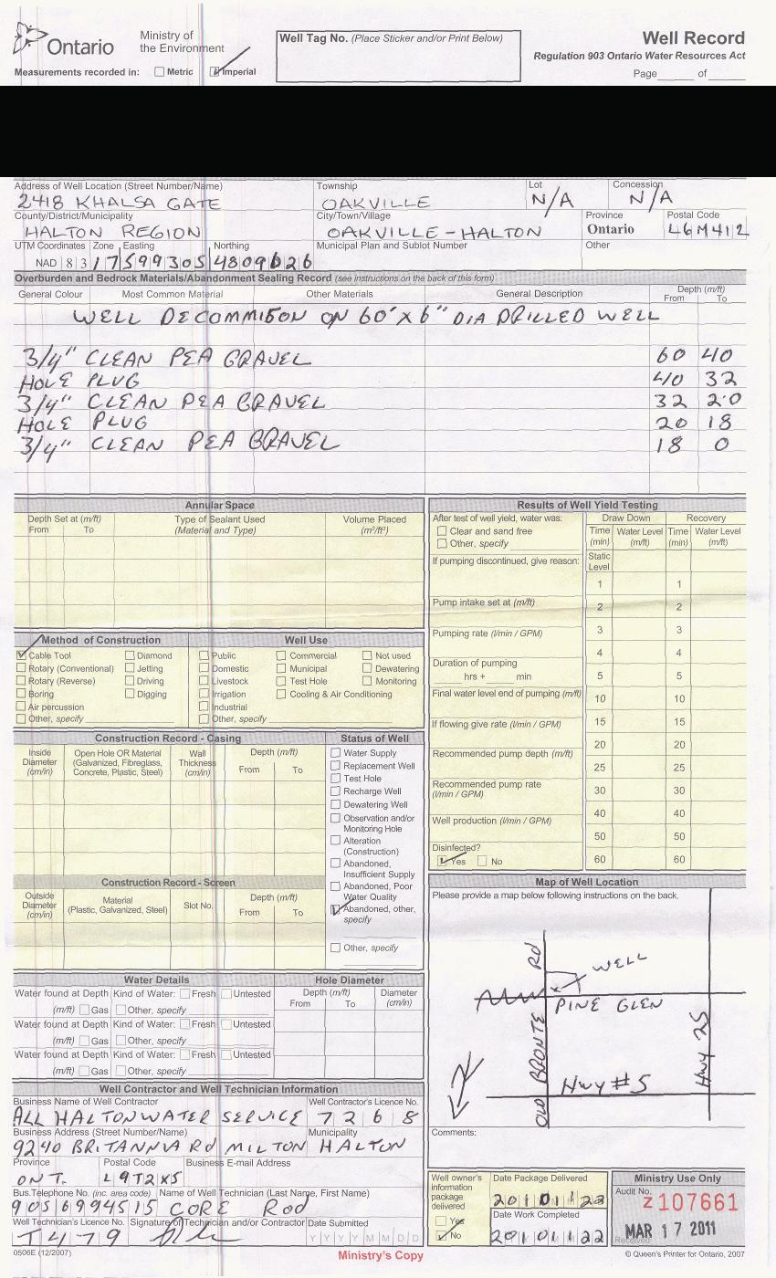
110

111
patersongroup Phase I - Environmental Site Assessment 450 Churchill Avenue North Ottawa, Ontario Prepared For Kitchissippi United Church March 8, 2010
 Geotechnical Engineering patersongroup Environmental Engineering Hydrogeology Geological Engineering Materials Testing 450 Churchill Avenue North Building Science Prepared For Kitchissippi United Church
Prepared for Florida State University Facilities Planning& Construction By Environmental Health & Safety Tallahassee, Fl
 SITE ASSESSMENT CHECKLIST FOR DEMOLITION AND RENOVATION PROJECTS INSERT BUILDING NAME FSU BUILDING NUMBER XXX CAMPUS OF FLORIDA STATE UNIVERSITY TALLAHASSEE, FLORIDA Prepared for Florida State University
patersongroup Phase I - Environmental Site Assessment Proposed Cardinal Creek Village Subdivision Lands Old Montreal Road Ottawa (Cumberland), Ontario
, Ontario") Geotechnical Engineering patersongroup Environmental Engineering Hydrogeology Geological Engineering Materials Testing Archaeological Studies Building Science Proposed Cardinal Creek Village Subdivision
Geotechnical Engineering patersongroup Environmental Engineering Hydrogeology Geological Engineering Materials Testing Archaeological Studies Building Science Proposed Cardinal Creek Village Subdivision
patersongroup Phase I Environmental Site Assessment Commercial Property 890 and 900 Bank Street Ottawa, Ontario Prepared For Canderel Management Inc.
 Geotechnical Engineering patersongroup Environmental Engineering Hydrogeology Geological Engineering Materials Testing Building Science Phase I Environmental Site Assessment Commercial Property 890 and
5.14 CONTAMINATED MATERIALS
 5.14 CONTAMINATED MATERIALS 5.14.1 Introduction Contaminated materials are toxic or potentially harmful substances that may be present in soil, groundwater, and building materials. Contaminated materials
Prepared for: Research Division Canada Mortgage and Housing Corporation 700 Montreal Road Ottawa, Ontario K1A 0P7. CMHC Project Manager: Don Fugler
 PHASE 1 ENVIRONMENTAL SITE ASSESSMENT INTERPRETATION GUIDELINES Prepared for: Research Division Canada Mortgage and Housing Corporation 700 Montreal Road Ottawa, Ontario K1A 0P7 CMHC Project Manager: Don
n introduction to environmental site assessments
 a n introduction to environmental site assessments CMHC Home to Canadians Canada Mortgage and Housing Corporation (CMHC) is the Government of Canada s national housing agency. We help Canadians gain access
patersongroup Phase I Environmental Site Assessment Vacant Property 3735 St. Joseph Boulevard Ottawa, Ontario Prepared For Mr.
 Geotechnical Engineering patersongroup Environmental Engineering Hydrogeology Geological Engineering Materials Testing Building Science Phase I Environmental Site Assessment Vacant Property 3735 St. Joseph
Property Condition Assessment
 Property Condition Assessment Pewaukee, WI 53072 Inspection Date: 1/6/15 Prepared For: Report Number: Prepared By: Shamrock Building Inspection Consultants LLC N29 W29951 Shel-Mar Dr. Pewaukee, WI 53072
Phase I Environmental Site Assessment
 Phase I Environmental Site Assessment 256 Rideau Street & 211 Besserer Street Ottawa, Ontario Prepared For: DCR Phoenix Development Corporation Limited 18 Bentley Avenue Ottawa, Ontario K2E 6T8 Trow Associates
Project & Environmental Review. Guidelines Demolition. May 2016
 Project & Environmental Review Guidelines Demolition May 2016 TABLE OF CONTENTS 1. Introduction... 3 2. Objectives... 3 3. Applicability and Building Permits... 3 4. Guidelines for Preparing a Project
PHASE I ENVIRONMENTAL SITE ASSESSMENT
 PHASE I ENVIRONMENTAL SITE ASSESSMENT Commercial and Light Industrial Development Area North of Prairie Street Between Corbin and Shirley Avenues Northridge, California AES Project No. 02-225 June 13,
IN THE PROVINCIAL COURT OF ALBERTA CRIMINAL DIVISION HER MAJESTY THE QUEEN. -and- GAS PLUS INC. STATEMENT OF AGREED FACTS
 IN THE PROVINCIAL COURT OF ALBERTA CRIMINAL DIVISION BETWEEN: HER MAJESTY THE QUEEN -and- GAS PLUS INC. STATEMENT OF AGREED FACTS Gas Plus Inc. stands charged that: Count1 On or between the 1st day of
FORM 4340 ENVIRONMENTAL QUESTIONNAIRE
 FORM 4340 ENVIRONMENTAL QUESTIONNAIRE ENVIRONMENTAL QUESTIONNAIRE Persons to be Questioned The following questions should be asked of the current owner of the property any commercial occupant of the property
(this cover page left intentionally blank)
") 4. Siting the Well (this cover page left intentionally blank) 4. Siting the Well Chapter Table of Contents Chapter Table of Contents Chapter Description... 4 Regulatory Requirements Well Siting... 4 Relevant
4. Siting the Well (this cover page left intentionally blank) 4. Siting the Well Chapter Table of Contents Chapter Table of Contents Chapter Description... 4 Regulatory Requirements Well Siting... 4 Relevant
APPENDIX L: CONTAMINATED MATERIALS AND WASTE MANAGEMENT
 APPENDIX L: CONTAMINATED MATERIALS AND WASTE MANAGEMENT L.1 INTRODUCTION Environmental Planning & Management, Inc. (EPM), as subconsultant to The Louis Berger Group, Inc., and on behalf of Metropolitan
GENERAL SPECIFICATION FOR THE MANAGEMENT OF EXCESS MATERIALS
 ONTARIO PROVINCIAL STANDARD SPECIFICATION METRIC OPSS 180 NOVEMBER 2005 GENERAL SPECIFICATION FOR THE MANAGEMENT OF EXCESS MATERIALS TABLE OF CONTENTS 180.01 SCOPE 180.02 REFERENCES 180.03 DEFINITIONS
Soil Treatment Facility Design and Operation for Bioremediation of Hydrocarbon Contaminated Soil. Version 1.0
 PROTOCOL 15 FOR CONTAMINATED SITES Soil Treatment Facility Design and Operation for Bioremediation of Hydrocarbon Contaminated Soil Version 1.0 Prepared pursuant to Section 64 of the Environmental Management
Land Reclamation Site Siting and Application Guidelines
 Department of Environment and Local Government Land Reclamation Site Siting and Application Guidelines Rationale In an effort to reduce the cost associated with the transportation of demolition wastes,
TOWN OF ROTTERDAM RESIDENTIAL BUILDING PERMIT APPLICATION Ext. 395 Needed to Obtain Permit:
 TOWN OF ROTTERDAM RESIDENTIAL BUILDING PERMIT APPLICATION 355-7575 Ext. 395 Needed to Obtain Permit: 1. Building Permit Application, and/or residential plumbing permit application, as applicable, to be
PHASE ONE ENVIRONMENTAL SITE ASSESSMENT 100 INLET PRIVATE OTTAWA, ONTARIO
 PHASE ONE ENVIRONMENTAL SITE ASSESSMENT 100 INLET PRIVATE OTTAWA, ONTARIO Prepared for: Brigil 98 Lois Street Gatineau, QC J8Y 3R7 SPL Project No.:10000024-720 January 27, 2014 ii TABLE OF CONTENTS 1.
REASON FOR SUBMISSION ADDRESS OF SUBJECT PROPERTY(IES) PID(s) & LEGAL DESCRIPTION(S)
 PID(s) & LEGAL DESCRIPTION(S)") Site Profile Waiver Planning Department-Development Services Division 171 Main St. Penticton B.C. V2A 5A9 P: (250) 490-2501 E: development@penticton.ca The City of Penticton requires applicants who are
Site Profile Waiver Planning Department-Development Services Division 171 Main St. Penticton B.C. V2A 5A9 P: (250) 490-2501 E: development@penticton.ca The City of Penticton requires applicants who are
Building Inspection Report
 Building Inspection Report Sample Commercial Inspection Report Inspection Date: Prepared For: Prepared By: Professional Property Inspection Consultants 4857 Winterset Drive Columbus, OH 43220 (614) 459-5941
Phase I Environmental Site Assessment 5155 Mississauga Rd., Mississauga, ON
 2017/10/24 Phase I Environmental Site Assessment 5155 Mississauga Rd., Mississauga, ON Project 15*4249 BRUCE A. BROWN ASSOCIATES LIMITED Consultants in the Environmental & Applied Earth Sciences PHASE
OWNER S DUTIES. Designated Substances on construction projects BEFORE CONTRACTS ARE FINALIZED, THE PROJECT OWNER MUST DO THE FOLLOWING
 In Ontario, section 30 of the Occupational Health and Safety Act requires that a project owner identify designated substances on the project and provide a list to prospective constructors before contracts
COUNTY OF NEVADA COMMUNITY DEVELOPMENT AGENCY NEVADA COUNTY CDA GUIDELINES FOR ASH AND BURN DEBRIS CLEAN UP AND REMOVAL AFTER A FIRE
 COUNTY OF NEVADA COMMUNITY DEVELOPMENT AGENCY Environmental Health Department 950 MAIDU AVENUE, SUITE 170 NEVADA CITY, CA 95959-8617 (530) 265-1222 FAX (530) 265-9853 http://mynevadacounty.com Amy Irani,
Asbestos Consulting Radon Measurements Lead Assessments Indoor Air Quality Testing Mold Investigations. Project Number: Page 1 of 22
 Page 1 of 22 Asbestos Survey Project Summary Pursuant to your request; Environmental, Inc., has performed an Asbestos Building Survey on 8/13/2014 and limited to the above referenced location. The Interior/Exterior/Roof
PHASE II ENVIRONMENTAL ASSESSMENT REPORT. Burlington International Airport House Removals AIP 78
 PHASE II ENVIRONMENTAL ASSESSMENT REPORT Burlington International Airport House Removals AIP 78 110 & 120 Airport Parkway 31 Dumont Avenue 396 White Street 1375 & 1379 Airport Drive South Burlington, Vermont
12.0 Contaminated Materials
 12.0 Contaminated Materials 12.1 Introduction An investigation was performed to identify hazardous waste and contaminated material sites in the study area of the Columbia Pike Transit Initiative ( the
ENVIRONMENTAL SITE ASSESSMENT QUESTIONNAIRE
 100 Broadway Road, Dracut, MA 01826 ENVIRONMENTAL SITE ASSESSMENT QUESTIONNAIRE TO BE COMPLETED BY THE APPLICANT ADDRESS: 1a. Is the property used for an industrial use? 1b. Is any adjoining property used
EJ Industrial Spine BOA Nomination Study
 A. Selecting Priority Sites Section V. Redevelopment of Priority Sites Section IV of this Nomination Study presents a summary of the analyses of the Study Area and market conditions affecting the E-J BOA
Canadian Solar Developers Ltd.
 Canadian Solar Developers Ltd. Type of Document Draft Report Project Name Proposed Ground Mount Solar Facility L.P #5 8338 Scotchmere Drive, Strathroy, ON OPA FIT Program: FIT-FL67GB5 Project Number V00002250-00
KABA DEMOLITION INFORMATION PACKET
 I. Demolition Process Checklist Structures Requiring No Permit Residential Structures 200 Square Feet or Less Commercial Structures 120 Square Feet or Less Structures Requiring No Bond 1 and 2 Family Residential
Phase One Environmental Site Assessment
 Phase One nvironmental Site Assessment Undeveloped and Community Property Part Lot 10, Concession 2 and 7500 Derry Road, Milton, Ontario, L9T 7H6 Submitted to: 2471123 Ontario Inc. 1039 Fourth Line Milton,
Florida Department of Environmental Protection Bob Martinez Center 2600 Blair Stone Road Tallahassee, Florida
 Florida Department of Environmental Protection Bob Martinez Center 2600 Blair Stone Road Tallahassee, Florida 32399-2400 Division of Waste Management - Storage Tank Facility Registration Form Registration
FINAL PLAN OF REMEDIAL ACTION
 FINAL PLAN OF REMEDIAL ACTION DELAWARE CAR COMPANY Second and Lombard Streets Wilmington, Delaware DNREC Project No. DE-1059 October 2000 Department of Natural Resources and Environmental Control Division
Decision Memo. Administrative Site Disposal Old Agness Guard Station Compound
 Decision Memo Administrative Site Disposal Old Agness Guard Station Compound US Forest Service Pacific Northwest Region Rogue River-Siskiyou National Forest Legal Location: SW ¼ Section 7, T. 35 S., R.
BYRON TOWNSHIP BUILDING PERMIT APPLICATION 8085 Byron Center Ave SW., Byron Center, MI /Fax
 BYRON TOWNSHIP BUILDING PERMIT APPLICATION 8085 Byron Center Ave SW., Byron Center, MI 49315 616-878-9155/Fax 616-878-0699 Applicant to complete all items in Section I, II, III, IV, V Note: Separate applications
REQUIREMENTS FOR SUBSTANTIALLY DAMAGED AND SUBSTANTIALLY IMPROVED STRUCTURES
 REQUIREMENTS FOR SUBSTANTIALLY DAMAGED AND SUBSTANTIALLY IMPROVED STRUCTURES If your home or business incurred damage, the engineering department, in conjunction with the Flood Mitigation Officer, will
Environmental Assessment Matrix
 For FCC Use Only Date: Customer Name: Environmental Assessment Matrix Loan Number: Please complete each question. Some answers may require additional information. Attach additional documentation where
SITE PLAN AND ARCHITECTURAL REVIEW APPLICATION
 SITE PLAN AND ARCHITECTURAL REVIEW APPLICATION CITY OF GENEVA, NEW YORK The purpose of the site plan and architectural review process is to secure compliance with the City s Zoning Ordinance and to promote
INTRODUCTION. 1 Proposed Plan for the Former Lee Field Naval Air Station Landfill Area 2 Site
 1 Proposed Plan for the Former Lee Field Naval Air Station Landfill Area 2 Site U.S. Army Corps of Engineers, Jacksonville District Formerly Used Defense Site Program PROPOSED PLAN for the LANDFILL AREA
Environmental Compliance Checklist
 Purpose To identify potential environmental compliance requirements early in the project life cycle. For use by University project managers, project coordinators, and professional services consultants
Contaminated Land - Managing the Risk
 Contaminated Land - Managing the Risk Signatures removed from electronic version Submitted by... Peter Wigley Nominated Responsible Manager Approved by... Tom Stevenson Chairman, Civil Engineering Subject
4.05. Groundwater Program. Chapter 4 Section. Background. Follow-up to VFM Section 3.05, 2004 Annual Report. Ministry of the Environment
 Chapter 4 Section 4.05 Ministry of the Environment Groundwater Program Follow-up to VFM Section 3.05, 2004 Annual Report Chapter 4 Follow-up Section 4.05 Background Groundwater is defined as water located
TOWAMENCIN TOWNSHIP BUILDING PERMIT PROCEDURES
 TOWAMENCIN TOWNSHIP BUILDING PERMIT PROCEDURES NON-RESIDENTAL BUILDING PERMIT APPLICATION FORM PART I Location of Property Address, Zoning District, Parcel Number and Lot & Block must be provided on all
SECTION X. Northwest Tennessee Regional Harbor
 Memphis District SECTION X Northwest Tennessee Regional Harbor HAZARDOUS, TOXIC, RADIOACTIVE WASTE SURVEY April 2004 TABLE OF CONTENTS Introduction 1 Historical File Review 2 Federal Databases 3 Inquiry
Excavation of petroleum-contaminated soil and tank removal sampling Petroleum Remediation Program
 www.pca.state.mn.us Excavation of petroleum-contaminated soil and tank removal sampling Petroleum Remediation Program This document describes the requirements for excavating petroleum-contaminated soil
A homeowners/applicants guide to understanding and making application for a building permit.
 Building Standards Department Administration Centre 10 Wellington St. E. Alliston, ON L9R 1A1 Web Address: www.newtecumseth.ca Email: building@newtecumseth.ca Phone: 705-435-3900 or 905-729-0057 Fax: 705-435-1689
LIMITED POTENTIALLY HAZARDOUS MATERIAL BUILDING INSPECTION REPORT AND ASBESTOS BUILDING INSPECTION REPORT. for
 LIMITED POTENTIALLY HAZARDOUS MATERIAL BUILDING INSPECTION REPORT AND ASBESTOS BUILDING INSPECTION REPORT for Michigan State University Physical Plant Division Engineering and Architectural Services Department
THE CORPORATION OF THE TOWNSHIPSHIP OF ADELAIDE METCALFE
 THE CORPORATION OF THE TOWNSHIPSHIP OF ADELAIDE METCALFE BY-LAW #69-2011 Being a by-law respecting Construction, Demolition and Change of Use Permits and Inspections for the Township of Adelaide Metcalfe
CITY OF HAMILTON PUBLIC WORKS DEPARTMENT Hamilton Water Division
 CITY OF HAMILTON PUBLIC WORKS DEPARTMENT Hamilton Water Division TO: Chair and Members Public Works Committee COMMITTEE DATE: March 17, 2014 SUBJECT/REPORT NO: Accelerated Remediation of Illegal Sewer
Building Permit Applications for new home construction will not be accepted unless the following documentation is included at the time of submission:
 Building Permit Applications for new home construction will not be accepted unless the following documentation is included at the time of submission: Copy of Alberta Government s New Home Registration
The following materials and documents are required in order for you to obtain a Building Permit:
 Imperial Municipal Services 263 Northland Drive Rockford, MI 49341 (616)863-9294 or 1-800-442-2794 Fax: (616)863-9298 E-mail: info@imsinspections.com Algoma Township 10531 Algoma Ave. NE Rockford, MI 49341-7108
PHASE I ENVIRONMENTAL SITE ASSESSMENT REPORT
 PHASE I ENVIRONMENTAL SITE ASSESSMENT REPORT AIP #74 Various Properties South Burlington, Vermont 05403 October 14, 2011 Prepared for: Stantec Consulting Inc. 55 Green Mountain Drive South Burlington,
PHASE I ENVIRONMENTAL SITE ASSESSMENT REPORT
 PHASE I ENVIRONMENTAL SITE ASSESSMENT REPORT Miscellaneous Property Group Various Properties South Burlington, Vermont 05403 October 14, 2011 Prepared for: Stantec Consulting Inc. 55 Green Mountain Drive
Permit Requirements: Building Codes: The City of Clanton has adopted the following codes which are enforced by the Building Department:
 Permit Requirements: Any owner, authorized agent, or contractor who desires to construct, enlarge, alter, repair, move, demolish, or change the occupancy of a building or structure, or to erect, install,
SOIL CONTAMINATION REVIEW QUESTIONNAIRE
 SOIL CONTAMINATION REVIEW QUESTIONNAIRE All applications for: rezoning, subdivision, development permit and development variance permit are to be accompanied by a completed questionnaire in order to determine
Commercial Tax Abatement
 A confirmation letter is issued by the City upon receipt of this application. This application is not effective and not considered filed until the confirmation letter has been issued. Filing does not assure
One and Two Family Additions
 One and Two Family Additions An addition to a house, duplex, garage, or an accessory structure requires a building permit prior to performing any construction. Building Department & Permit Office Mon-Fri
CITY OF GLASGOW BUILDING PERMIT APPLICATION 126 E. Public Square Glasgow, KY Phone: (270) Fax: (270)
 Fax: (270)") CITY OF GLASGOW BUILDING PERMIT APPLICATION 126 E. Public Square Glasgow, KY 42141 Phone: (270) 651-3921 Fax: (270) 651-9553 Permit # Filing Date: Total Fee: Property Property Owner: Subdivision: Lot #
CITY OF GLASGOW BUILDING PERMIT APPLICATION 126 E. Public Square Glasgow, KY 42141 Phone: (270) 651-3921 Fax: (270) 651-9553 Permit # Filing Date: Total Fee: Property Property Owner: Subdivision: Lot #
Phase I Environmental Site Assessment 1575 Diamondview Road Ottawa, Ontario
 Phase I Environmental Site Assessment 1575 Diamondview Road Ottawa, Ontario Prepared for: 795144 Ontario Inc. 140 Stonehome Crescent Almonte, ON K0A 1A0 Attention: Mr. H. Joseph Reis November 2013 Pinchin
LOT GRADING GUIDELINES
 LOT GRADING GUIDELINES RESIDENTIAL PROPERTIES The Drainage Bylaw 16200 came into effect on June 1, 2013 replacing previous versions of the Surface Drainage Bylaw 11501. This Bylaw requires that all single
BUILDING PERMIT INFORMATION GUIDE FOR THE HOMEOWNER
 THE CORPORATION OF THE MUNICIPALITY OF SOUTH HURON 322 Main Street South, P.O. Box 759, Exeter, Ontario N0M 1S6 PHONE: (519) 235-0310 FAX: (519) 235-3304 TOLL FREE: 1-877-204-0747 WEBSITE: www.southhuron.ca
HOLDING TANK PLANNING & INSTALLATION GUIDELINES
 HOLDING TANK PLANNING & INSTALLATION GUIDELINES Under no circumstances is sewage from a holding tank to be discharged onto the surface of the ground or into groundwater or surface waters. TABLE OF CONTENTS
2016 CALGREEN RESIDENTIAL CHECKLIST MANDATORY ITEMS City of San Carlos - Building Division 600 Elm Street, San Carlos, CA Phone:
 2016 CALGREEN RESIDENTIAL CHECKLIST MANDATORY ITEMS City of San Carlos - Building Division 600 Elm Street, San Carlos, CA 94070 Phone: 650-802-4261 PURPOSE: The residential provisions of the 2016 CalGreen
Rock Fill Layer Management and Maintenance Plan Former BNSF Site 13 Highway 99 Eugene, Oregon
 Rock Fill Layer Management and Maintenance Plan 13 Highway 99 Prepared for: Half Moon LLC P.O. Box 25112 97402 PBS Project No. 51833.000 Rock Fill Layer Management and Maintenance Plan TABLE OF CONTENTS
Detached Garage Construction Information
 Detached Garage Construction Information In order to issue a building permit for construction of a detached garage, the applicant must submit: Completed development and building permit applications Method
Permit To Take Water Inspection Report
 Ministry of the Environment and Climate Change Ministère de l Environnement et de l Action en matière de changement climatique Permit To Take Water Inspection Report Client: Inspection Site Address: Miller
CONTAMINATED MEDIA MANAGEMENT PLAN MIDLAND MARKET RAIL YARD KLAMATH FALLS, OREGON DEQ ECSI SITE #1732 MAY 4, 2009 FOR BNSF RAILWAY COMPANY
 CONTAMINATED MEDIA MANAGEMENT PLAN MIDLAND MARKET RAIL YARD KLAMATH FALLS, OREGON DEQ ECSI SITE #1732 MAY 4, 2009 FOR BNSF RAILWAY COMPANY File No. 0506-013-07 Contaminated Media Management Plan Midland
PIER 26 and 28 BULKHEAD LIMITED ASBESTOS and LEAD SURVEY NTE Project No.: NT-3278
 PIER 26 and 28 BULKHEAD LIMITED ASBESTOS and LEAD SURVEY NTE Project No.: NT-3278 PREPARED FOR: Mr. Roberto Aguirre City of San Francisco DPW, SAR, BCM 1680 Mission Street San Francisco, California PREPARED
APPENDIX M: Hazardous Waste Technical Report
 APPENDIX M: Hazardous Waste Technical Report M.1 Existing Conditions A hazardous waste review was conducted to provide preliminary information regarding the potential presence of any hazardous substances
Linde FUSRAP Site Tonawanda, New York
 Linde FUSRAP Site Tonawanda, New York U.S. Army Corps of Engineers Building Strong Buffalo District February 2016 FORMERLY UTILIZED SITES REMEDIAL ACTION PROGRAM The Formerly Utilized Sites Remedial Action
REQUEST FOR TENDER - SERVICES RFT HOUSE DEMOLITION 7958 BEAVERDAMS RD., NIAGARA FALLS, ON.
 REQUEST FOR TENDER - SERVICES 1. PURPOSE AND SCOPE This specification is intended to govern the supply of all labour, materials and equipment for the dismantling, demolition of a single dwelling on the
Top 10 Risks of the Clean Fill Dump Site
 Top 10 Risks of the Clean Fill Dump Site Definition in Uxbridge and Scugog Site-Alteration By-laws commercial fill operation -means the placing or dumping of fill involving remuneration paid, or any other
Application for a Sewage System Permit
 Application for a Sewage System Permit Sewage System Inspectors can only provide comments based on completed applications and plans. Once a completed application has been received and reviewed, an inspector
Indoor Building Survey and Product Inventory
 Indoor Building Survey and Product Inventory Preparer s Name Date/Time Prepared Preparer s Affiliation Phone No. Purpose of Investigation 1. OCCUPANT: Interviewed: Y / N Last Name: First Name: Address:
BuildingName The Description of the Project P DOCUMENTS
 ARCHITECTURE, ENGINEERING AND CONSTRUCTION P00000000 0000 DOCUMENTS ARCHITECTURE & ENGINEERING 326 East Hoover, Mail Stop B Ann Arbor, MI 48109-1002 Phone: 734-764-3414 Fax: 734-936-3334 SPECIFICATION
LOWER DUNGENESS RIVER SECTION 544 ECOSYSTEM RESTORATION
 LOWER DUNGENESS RIVER SECTION 544 ECOSYSTEM RESTORATION APPENDIX F HAZARDOUS, TOXIC AND RADIOACTIVE WASTE DRAFT Detailed Project Report and Environmental Assessment DUNGENESS RIVER ECOSYSTEM RESTORATION
A Case Study in Brownfield Development Ponce City Market
 Georgia Environmental Conference A Case Study in Brownfield Development Ponce City Market John C. Spinrad, Partner Ponce City Market 2 Atlanta s Most Iconic Redevelopment Jamestown, the owner of Ponce
Application for a Sewage System Permit
 Application for a Sewage System Permit The following forms must be completed and returned with the appropriate fee. 1. Application for a Permit to Construct or Demolish; 2. Schedule 1: Designer Information;
Executive Summary. Consistent with Schedule 3 of the Environmental Assessment Act, IWM is submitting for evaluation this registration document.
 Executive Summary Island Waste Management Inc. (IWM) has been successfully operating a biomedical waste collection and disposal system for the Newfoundland and Labrador Health Boards Association (NLHBA)
Zoning- check the zoning on the property you are planning to build on, this can be done at the municipal office.
 SINGLE DETACHED DWELLING Before your application can be deemed complete and ready for processing you will need the following: (Please hand in entire application package including this cover sheet) Zoning-
IV. Environmental Impact Analysis E. Hazards and Hazardous Materials
 IV. Environmental Impact Analysis E. Hazards and Hazardous Materials 1. Introduction This section provides an analysis of the project s potential impacts relative to hazards and hazardous materials. The
SepticDesign.ca Gunnell Engineering Ltd.
 SepticDesign.ca Gunnell Engineering Ltd. Presentation Summary Best Practices Code Context Prior to Attending the Site When on Site Site Assessment Assessing Existing Sewage Systems The Septic Test Pit
Received by:* Date Received:* Zoning Approval:* Date:* PERMIT#:* *ZONING: *SETBACKS: FRONT ft/ SIDE ft/ REAR ft *FLOOD ZONE:
 HENDRY COUNTY BUILDING, LICENSING & CODE ENFORCEMENT POST OFFICE BOX 2340 * 640 SOUTH MAIN STREET * LABELLE, FLORIDA 33975 * (863) 675-5245 * FAX: (863) 674-4194 1100 OLYMPIA ST CLEWISTON, FLORIDA 33440
BUILDING PERMIT GUIDELINES - RESIDENTIAL
 TOWN OF MIDLAND 575 Dominion Avenue Midland, ON L4R 1R2 Phone: 705-526-4275 Fax: 705-526-9971 building@midland.ca BUILDING PERMIT GUIDELINES - RESIDENTIAL Applicable Law Description Required Zoning Certificate
BUILDING PERMIT APPLICATION PACKAGE
 BUILDING PERMIT APPLICATION PACKAGE NOTICE TO BUILDING PERMIT APPLICANTS In addition to completed applications forms, the following documentation is required to accompany all building permit applications
The Corporation of The City of London
 The Corporation of The City of London Legislative Health and Safety Requirements The following is a health and safety guide for those providing a tender to assist in determining legislative health and
GUIDELINES FOR SUBMISSION OF AN APPLICATION FOR A SEWAGE SYSTEM PERMIT
 GREY BRUCE HEALTH UNIT Owen Sound (Head Office) 920 1st Ave. W. N4K 4K5 (519) 376-9420 (800)-263-3456 Durham P.O. Box 417 N0G 1R0 (519) 369-3318 (800) 394-6643 Southampton P.O. Box 213 N0H 2L0 (519) 797-2010
2015 ANNUAL ENGINEERING INSPECTION REPORT ENTERGY INDEPENDENCE PLANT CLASS 3N LANDFILL PERMIT NO S3N-R2 AFIN:
 2015 ANNUAL ENGINEERING INSPECTION REPORT ENTERGY INDEPENDENCE PLANT CLASS 3N LANDFILL PERMIT NO. 0200-S3N-R2 AFIN: 32-00042 JANUARY 15, 2016 ENTERGY INDEPENDENCE PLANT CLASS 3N LANDFILL 2015 ANNUAL ENGINEERING
2015 ANNUAL ENGINEERING INSPECTION REPORT ENTERGY WHITE BLUFF PLANT CLASS 3N LANDFILL PERMIT NO S3N-R3 AFIN:
 2015 ANNUAL ENGINEERING INSPECTION REPORT ENTERGY WHITE BLUFF PLANT CLASS 3N LANDFILL PERMIT NO. 0199-S3N-R3 AFIN: 35-00110 JANUARY 15, 2016 ENTERGY WHITE BLUFF PLANT CLASS 3N LANDFILL 2015 ANNUAL ENGINEERING
POTENTIALLY HAZARDOUS MATERIALS BUILDING INSPECTION REPORT. for. SSOE, Inc Wilshire Drive Suite 260 Troy, Michigan 48084
 POTENTIALLY HAZARDOUS MATERIALS BUILDING INSPECTION REPORT for SSOE, Inc. 1050 Wilshire Drive Suite 260 Troy, Michigan 48084 at Michigan State University Physics Astronomy Building (Now Psychology) East
RESIDENTIAL CONSTRUCTION PERMIT FEES
 RESIDENTIAL CONSTRUCTION PERMIT FEES R-1 Building Permit: One- or Two-Family New Construction (Complete Permit Packet) Combination permit to include Building, Electrical, Mechanical, Plumbing (to include
Foundation/Site Work Code Requirements
 Q: What is a Foundation Only permit and why did I receive one when I filed for a full Building Permit? All Building Permits for new construction and additions are reviewed for zoning compliance. This review
Municipal Infrastructure
 The Town of Hebron Section 5 2014 Plan of Conservation and Development Municipal Infrastructure C. Public Works (Draft: 5/2/13) This section of the plan will identify the services provided by the Town
Tim Nelson, Facilities Management's Asbestos Coordinator, 400 Donhowe Building Dan Allen, Associate Director, Recreation Sports, 108 Cooke Hall
 July 3, 2007 REPORT: Full Building Survey TO: Tim Nelson, Facilities Management's Asbestos Coordinator, 400 Donhowe Building Dan Allen, Associate Director, Recreation Sports, 108 Cooke Hall FROM: Bryan
Prepared By: VERTEX Environmental Services, Inc. 400 Libbey Parkway Weymouth, MA May 18, Prepared For:
 Phase I Environmental Site Assessment 7 th Street Station 1100 Southwest 7 th Street Corvallis, Oregon 97333 VERTEX Project No. 18683 VERTEX Prepared By: VERTEX Environmental Services, Inc. 400 Libbey
Project Background. Project Purpose
 August 21, 2015 Ms. Suzanne Wynn Project Manager Gainesville Community Redevelopment Agency 802 NW 5th Avenue, Suite 200 Gainesville, Florida 32601 Re: Order of Magnitude Estimates for Environmental Assessment/Remediation
Topographical & Geotechnical Surveys
 STANDARD TEXT GUIDELINE FOR Topographical & Geotechnical Surveys for ELEMENTARY AND SECONDARY SCHOOLS Prepared by the Design Department DATE ISSUED MARCH 2002 LATEST REVISIONS IN GREEN FONT REV 1 JAN 2003