Doyle Park Reconstruction Project Improving Flood Control Facilities to Meet a TMDL
|
|
|
- Anthony Long
- 6 years ago
- Views:
Transcription


1 Doyle Park Reconstruction Project Improving Flood Control Facilities to Meet a TMDL Ann Arbor, Michigan Washtenaw County Drain Commissioner & Malletts Creek Coordinating Committee November, 2007 Janis Bobrin - Washtenaw County Drain Commissioner Ed Kluitenberg, Mark TenBroek,, Jay Zawacki - CDM Michigan, Inc.
2 Presentation Overview Background Study/Design Construction Initial Performance Project Cost/Funding Future Activities
3 Background


4 Project Team Washtenaw County Drain Commissioner s Office MDEQ City of Ann Arbor Pittsfield Township Huron River Watershed Council Malletts Creek Association Consulting Team

5 Malletts Creek Watershed Doyle Park Regional Detention Basin


6 Existing Facility Designed for Flood Control NURP Sampling Removals TSS 35% Phos. 14%


7 Brown Park Recreational Uses Biking Walking Playground area Basketball Birding Sledding Disc golf
8 Malletts Creek Restoration Plan Plan completed in 2000 Relevant Goals: Reduce phosphorus pollution Control stream velocities and flow rates Increase habitat for fish and wildlife Change to Doyle Park was a keystone recommendation Installed Malletts Creek stream gage
9 Study/Design


10 Public Engagement Community workshops As-needed focus meetings Progress meetings w/ Malletts Creek Coordinating Committee Project web site
11 Refined Project Objectives Phosphorus Removal & Sediment Management (Meet TMDLs) Channel Integrity Habitat Diversity Public Health Protection Community Recreation and Educational Value Management and Maintenance Community Input/Education


12 Highly Variable Stream Flows
13 Malletts Creek Phosphorus Load Closely Related to Suspended Solids Load
14 Sampling / Monitoring of Existing Pond Temp. increases up to 14 deg F Zero TSS/Phos Phos.. removal Good aeration at outlet Strong diurnal DO - excess algae Dissolved Oxygen Concentration DO Conc. (mg/l) Upstream (BP1) Dow nstream (BP2) 8/27 8/28 8/29 8/30 8/31 9/1 9/2 9/3 9/4 9/5 9/6

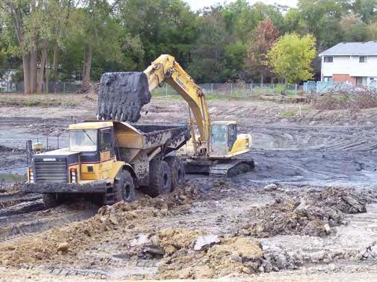
15 Sediment Characterization Average depth of 5 ft 33,000 CY 8 sediment cores analyzed for 12 metals Some results above direct contact threshold WCDC elected off- site disposal

16 Floristic Quality Assessments Wetland Overflow Area Old Field Oak/Hickory Woodland

17 Delineation of Existing Wetlands
18 Existing/Future Detention Volumes Figure Brown Park Detention Basin Volumes (MG) Flood Control Only Extended Detention Permanent Pool Accumulated Sediment Volume (MG) As-Built (1979) Existing Conditions (2003) Concept 1 Shallow Pond Concept 2 Meandering Stream Concept 3 Terraced Pools Concept 4 Stream w/ Forebay Concept 5a Deep Wetland Concept 5b Medium Depth Wetland
19 Continuous Simulation of Alternatives with SWMM EXTRAN Model

20 Annual Avg. Capture of Wet Weather Flows Annual Average Capture of Wet Weather Flows Capture 100% 90% 80% 70% 60% 50% 40% 30% 20% 10% 72 hour drawdown 48 hour drawdown 24 hour drawdown Concept 1 - Shallow Pond (34%) Concept 2 - Meandering Stream (64%) Concept 3 - Terraced Pools (82%) Concept 4 - Stream w/ Forebay (68%) Concept 5a - Deep Wetland (87%) Concept 5b - Medium Depth Wetland (83%) 0% Extended Detention Storage Volume (MG)
21 Predicted Pollutant Removal Efficiency Figure 1-3: Predicted Removal Efficiency by Sedimentation Removal Efficiency 80% 70% 60% 50% 40% 30% 20% 10% Total Suspended Solids Total Phosphorus 0% Concept 1 Shallow Pond Concept 2 Meandering Stream Concept 3 Terraced Pools Concept 4 Stream w / Forebay Concept 5a Deep Wetland Concept 5b Medium Depth Wetland

22 Selected Design Forebay w/ diversion and access road Extended detention wetland Mitigation wetland Embankment dam Modified outlet Expected performance ~ 35% Phos.. removal ~ 60% TSS removal


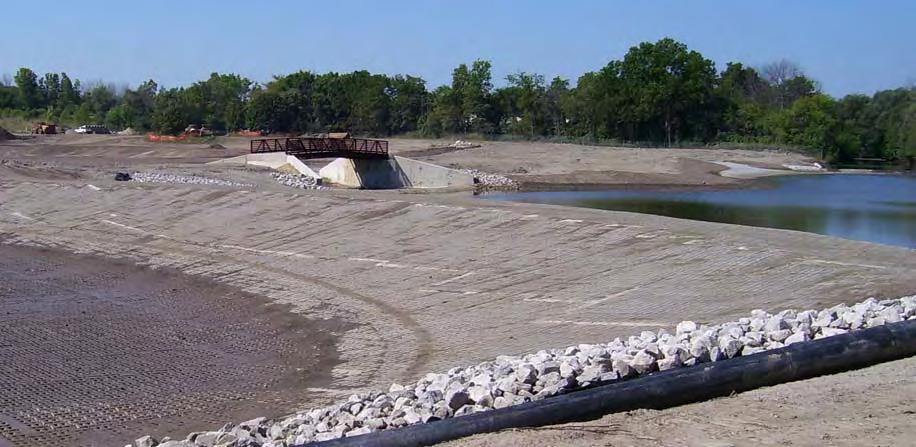
23 Creating a New Public Amenity - Inviting Increased Use Integrated disc golf course Expanded water use/access Pedestrian bridge Looped pathway Native landscaping Mitigation wetland forbs and grasses, high diversity, habitat structures Detention wetland forbs and grasses, lower diversity due to inundation depths Shoreline/upland areas trees, shrubs, forbs, grasses
24 Construction

25 Doyle Park Construction Fall 2006

26 Downstream End - Temporary Diversion Channel
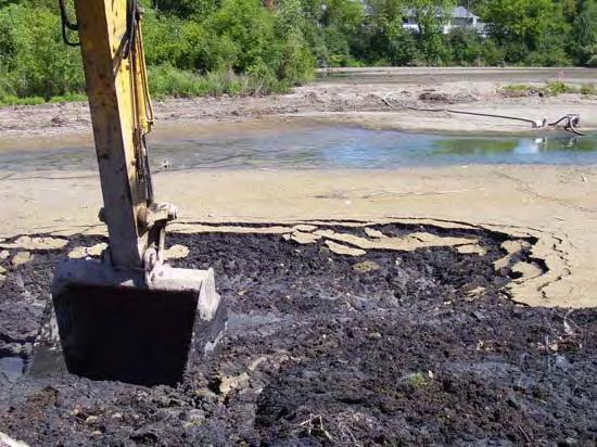
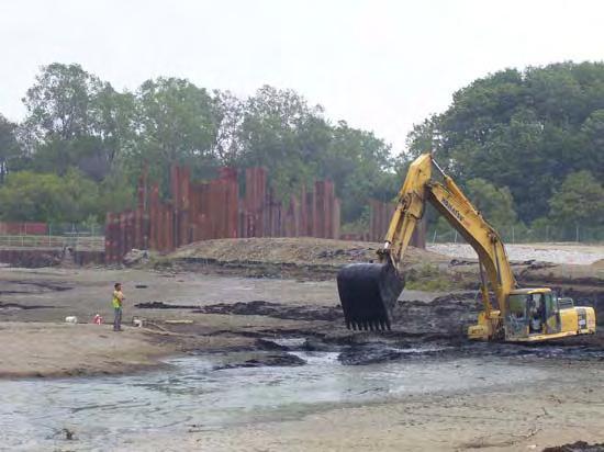

27 Sediment Removal/Drying

28 Upstream Weir Inlet to Forebay

29 Embankment Dam Construction

30 Doyle Park Construction August 2007
31 Outlet Structure Modifications

32 Extended Detention Wetland
33 Mitigation Wetland
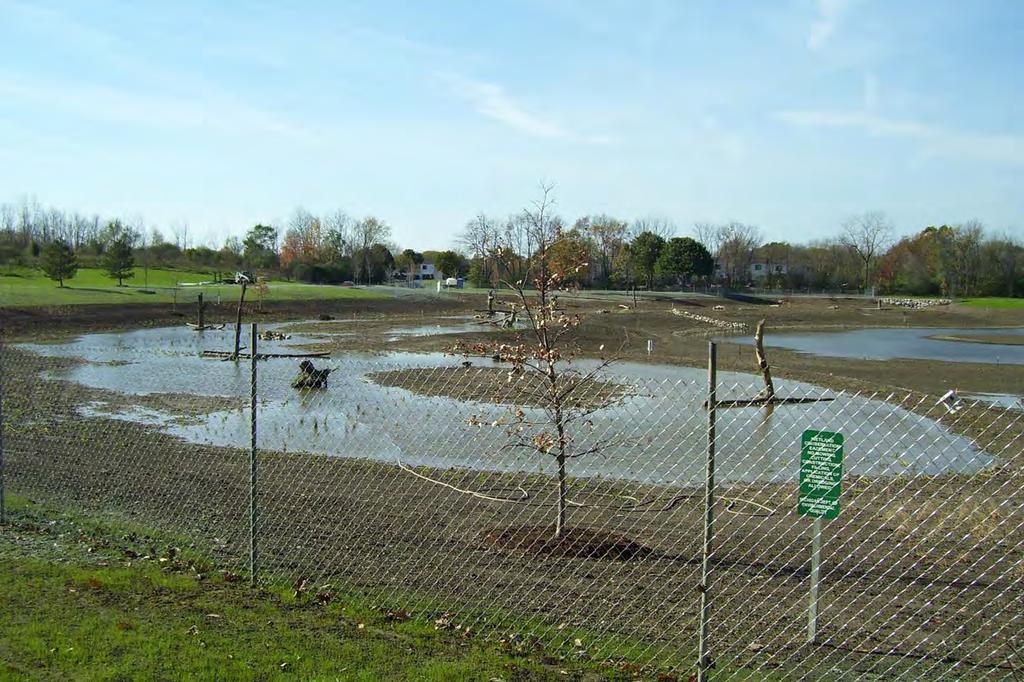
34 Initial Performance

35 Embankment Dam Construction Detention Activated

36 Embankment Dam Overtopping August 20, 2007

37 Embankment Dam Overtopping August 20, 2007
38 Project Costs / Funding Construction Cost $2.54 Million $1.25 Million CMI Grant First SRF-financed NPS project in Michigan % User Costs allocated to Malletts Creek Drainage District City of Ann Arbor Pittsfield Township MDOT Washtenaw County
39 Future Activities Construction completion: Fall 2007 Wetland mitigation monitoring & reporting Observation of plantings Floristic Quality Assessment Water quality sampling to establish actual TSS and phosphorus removal Long-term operation and maintenance
Natural and Engineered Wetlands for Stormwater Management
 Natural and Engineered Wetlands for Stormwater Management Dan Hitchcock, Ph.D., P. E. Baruch Institute of Coastal Ecology and Forest Science Clemson University Georgetown, SC Prominence and Diversity of
Middle Huron Stormwater Plan for Addressing Total Maximum Daily Loads (TMDLs)
") Middle Huron Stormwater Plan for Addressing Total Maximum Daily Loads (TMDLs) The following plan was developed by the Middle Huron Watershed Stormwater Advisory Group (SAG) a collaboration between communities
Middle Huron Stormwater Plan for Addressing Total Maximum Daily Loads (TMDLs) The following plan was developed by the Middle Huron Watershed Stormwater Advisory Group (SAG) a collaboration between communities
TABLE OF CONTENTS. Malletts Creek Restoration Project
 TABLE OF CONTENTS ii TABLE OF CONTENTS List of Acronyms ----------------------------------------------------------------------------v Executive Summary ---------------------------------------------------------------------
COON CREEK WATERSHED DISTRICT PERMIT REVIEW
 16-054 Woodland Creek Wetland Banking Restoration Project, Page 1 of 6 COON CREEK WATERSHED DISTRICT PERMIT REVIEW MEETING DATE: August 22, 2016 AGENDA NUMBER: 11 FILE NUMBER: 16-054 ITEM: Woodland Creek
Goose Management through Habitat Restoration
 Goose Management through Habitat Restoration presented at the Goose Management Workshop Bergen County Community College Paramus, New Jersey March 3, 2009 Christopher C. Obropta, Ph.D., P.E. Extension Specialist
Wood Canyon Emergent Wetland Project. City of Aliso Viejo 12 Journey, Suite 100 Aliso Viejo, CA 92656
 Wood Canyon Emergent Wetland Project City of Aliso Viejo 12 Journey, Suite 100 Aliso Viejo, CA 92656 Introduction Wood Canyon is located within Aliso and Wood Canyon Regional Park in southwest Orange County,
Information for File # PRH
 Information for File # 2016-02602-PRH Applicant Corps Contact Tom Morley Paul Hauser Address 152 Baker Drive, Redwood Falls, MN 56283 E-Mail Paul.R.Hauser@usace.army.mil Phone 651-290-5357 Primary County
Shingle Creek Watershed Management Commission Wetland 639W Outlet Modifications Summary Feasibility Report
 Shingle Creek Watershed Management Commission Wetland 639W Outlet Modifications Summary Feasibility Report The proposed project is the modification of the outlet of Wetland 27-0639W to reduce phosphorus
STORMWATER 101 May 2012
 STORMWATER 101 May 2012 Overview History Context and Basics Maps Systems Regulations Floodplains Impervious Surfaces Management Techniques Storm Sewer Design Footing Drain Disconnection Program (FDD) MS4
Biofilter Wetland at Harrow Run Water Quality Evaluation of Pollutant Removal Efficiency from a Tailwater Recovery System
 Objective and Scope Biofilter Wetland at Harrow Run Water Quality Evaluation of Pollutant Removal Efficiency from a Tailwater Recovery System In November of 2004, a biofilter wetland was installed to treat
Incorporating Restoration Planning and Transportation Controls into the Valley Creek Watershed Act 167 Stormwater Management Plan
 Incorporating Restoration Planning and Transportation Controls into the Valley Creek Watershed Act 167 Stormwater Management Plan Pennsylvania State Section American Water Resources Association Fall 2011
4.12. Detention Basins
 4.12. Detention Basins Detention Basins can be a cost effective method to provide temporary storage, conveyance, and treatment of runoff when used within the context of Low Impact Development (LID) strategies.
City of Fairmont Storm Water Pollution Prevention Plan (SWPPP) January 23, 2017
 January 23, 2017") City of Fairmont Storm Water Pollution Prevention Plan (SWPPP) January 23, 2017 Why is Water Quality Important? Water has always been important to Minnesota and is a key part of our history, culture, economy
City of Fairmont Storm Water Pollution Prevention Plan (SWPPP) January 23, 2017 Why is Water Quality Important? Water has always been important to Minnesota and is a key part of our history, culture, economy
Dry Swale Wet Swale Grass Channel Dry Well Permeable Pavement Bioretention DESIGN ELEMENTS
 FACILITY ID: DATE: / / ASSESSED BY: NAME: ADDRESS: PHOTO IDS: SECTION 1- BACKGROUND INFORMATION (GIS) BMP TYPE : Dry Detention Pond Extended Detention Pond Wet Pond Filter (specify: ) Infiltration (specify:
Standards for SWMF s. (Stormwater Management Facilities) Lacombe County s Guide to Developing Stormwater Management Facilities
 Lacombe County s Guide to Developing Stormwater Management Facilities") Standards for SWMF s (Stormwater Management Facilities) Lacombe County s Guide to Developing Stormwater Management Facilities August 2017 PREAMBLE Development results in a great amount of impervious area,
Standards for SWMF s (Stormwater Management Facilities) Lacombe County s Guide to Developing Stormwater Management Facilities August 2017 PREAMBLE Development results in a great amount of impervious area,
11. Public Utilities. Key Terminology: OVERVIEW STORMWATER MANAGEMENT WATERSHED MANAGEMENT ORGANIZATIONS AND COMMISSIONS. Inventory and Analysis
 Inventory and Analysis 11. Public Utilities Urbanized (drainage): Defined as an area where natural soils, waterways, and environmental functions are replaced with impervious surfaces (roads, parking lots,
Constructed Wetland Pond T-8
 Constructed Wetland Pond T-8 Description A constructed wetlands pond is a shallow retention pond designed to permit the growth of wetland plants such as rushes, willows, and cattails. Constructed wetlands
Hoosier Creek Watershed All of Ely drains into Hoosier Creek, which runs north to south along the west side of Ely. Hoosier Creek, Hydrologic Unit Cod
 Hoosier Creek Watershed All of Ely drains into Hoosier Creek, which runs north to south along the west side of Ely. Hoosier Creek, Hydrologic Unit Code (HUC) 8 07080208, drains into the Coralville Reservoir,
Engineered Stormwater Controls
 Engineered Stormwater Controls Complying with the Water Supply Watershed Protection Act New regulations have been developed to protect water quality in areas of North Carolina where surface waters-streams,
4. Ponds and infiltration BMPs can achieve 60 to 100% removal efficiencies for sediment.
 Landscape BMPs For the purposes of this project, preventive measures have been categorized into two categories: landscape BMPs and source prevention BMPs. Landscape BMPs includes both vegetative practices
Constructed Wetland Use in Nonpoint Source Control
 Constructed Wetland Use in Nonpoint Source Control Description Constructed wetlands are excavated basins with irregular perimeters and undulating bottom contours into which wetland vegetation is purposely
BCWMC Capital Improvement Program (approved April 19, 2018; pending minor Plan amendment)
") BCWMC Capital Improvement Program 2020 2024 (approved April 19, 2018; pending minor Plan amendment) Project Name City Number 2019 2020 2021 2022 2023 2024 2025 Totals Medicine Lake Rd and Winnetka Ave
BCWMC Capital Improvement Program 2020 2024 (approved April 19, 2018; pending minor Plan amendment) Project Name City Number 2019 2020 2021 2022 2023 2024 2025 Totals Medicine Lake Rd and Winnetka Ave
Public Information Centre September 19 th, 2017
 Public Information Centre September 19 th, 2017 WELCOME! Public Information Centre for the Maple Hill Creek Rehabilitation Class Environmental Assessment Please take the time to sign our sign in sheet
RETENTION BASIN EXAMPLE
 -7 Given: Total Tributary Area = 7.5 ac o Tributary Area within Existing R/W = 5.8 ac o Tributary Area, Impervious, Outside of R/W = 0.0 ac o Tributary Area, Pervious, Outside of R/W = 1.7 ac o Tributary
Outcomes. Kelly Karll-SEMCOG Margaret Barondess - MDOT
 Eco-Logical: I-75 Corridor I-75 Conservation Transportation Action Planning in to Monroe Achieve County: Multiple Stormwater Environmental Considerations Outcomes Kelly Karll-SEMCOG Karll@semcog.org Margaret
Michael Pennington, DEQ
 MDEQ s Wetland Mitigation Bank Funding (WMBF) Program Michael Pennington, DEQ Presentation Outline Wetland Banking Overview Current Status of Wetland Banking in Michigan Wetland Mitigation Bank Funding
[] The Red Cedar River and its Streams (Fall 2001)
![[] The Red Cedar River and its Streams (Fall 2001)](/thumbs/81/84582489.jpg "[] The Red Cedar River and its Streams (Fall 2001)") [] The Red Cedar River and its Streams (Fall 2001) This is an opportunity for you to provide information for local water resource planning. Your input will help planners make informed water quality decisions.
[] The Red Cedar River and its Streams (Fall 2001) This is an opportunity for you to provide information for local water resource planning. Your input will help planners make informed water quality decisions.
Municipal Stormwater Management Plan Prepared For The Borough of Cape May Point By Van Note-Harvey Associates VNH File No.
 Municipal Stormwater Management Plan Prepared For The Borough of Cape May Point By Van Note-Harvey Associates 2005 VNH File No. 35317-210-21 Table of Contents Introduction... 3 Goals... 3 Storm water Discussion...
PROTECTING OUR WATERWAYS: STORMWATER POLLUTION REDUCTION EFFORTS
 PROTECTING OUR WATERWAYS: STORMWATER POLLUTION REDUCTION EFFORTS Public Information Meeting ~ May 2, 2018 Public Works Stormwater Management Division OVERVIEW Surface Water Quality Protection Municipal
Osher Course. What Lies Beneath the Inland Bays?
 Osher Course What Lies Beneath the Inland Bays? Objectives for Course Describe the Delaware Inland Bays and their tributaries Illustrate the ecology and importance of estuaries Demonstrate the threats
How Climate Change Impacts Urban Runoff and Water Quality Design
 How Climate Change Impacts Urban Runoff and Water Quality Design by J. C. Hayes, C. Privette, III and S. J. Klaine AWRA Conference Anchorage, AK May 4-7, 2009 Presentation Outline Introduction: Why manage
Stevenson Creek Watershed Plan and Project Implementation
 Stevenson Creek Watershed Plan and Project Implementation 1999-2007 Stevenson Creek Watershed Management Plan (WMP) Project Site The Watershed Management Plan was completed in 2001 with cooperative funding
I. Welcome & Introductions WPAC History (Paul Racette, PEC)
") Poquessing Creek Watershed ACT 167 STORM WATER MANAGEMENT PLAN Public Hearing July 10, 2012 I. Welcome & Introductions ---------- WPAC History (Paul Racette, PEC) Primary WPAC Members: Bucks County: Bensalem
Poquessing Creek Watershed ACT 167 STORM WATER MANAGEMENT PLAN Public Hearing July 10, 2012 I. Welcome & Introductions ---------- WPAC History (Paul Racette, PEC) Primary WPAC Members: Bucks County: Bensalem
SECTION 10: WETLANDS PROTECTION
 SECTION 10: WETLANDS PROTECTION 10-1 INTENT AND PURPOSE A. Intent 1. The City finds that wetlands serve a variety of beneficial functions. Wetlands maintain water quality, reduce flooding and erosion,
Blue Lake Stormwater Retrofit Analysis
 P a g e 1 Blue Lake Stormwater Retrofit Analysis Prepared by: Isanti Soil and Water Conservation District And Sherburne Soil and Water Conservation District P a g e 4 Executive Summary Blue Lake and its
Wetland Monitoring. City of Edmonton. Edmonton Wetlands Workshop December 4-5, 2013
 Wetland Monitoring City of Edmonton Edmonton Wetlands Workshop December 4-5, 2013 City of Edmonton Presentation Outline Kennedale Wetland Water Quality Sediment removal Vegetation management Biological
PRENTISS CREEK (SUB-E) KENSINGTON PLACE CONCEPT PLAN VILLAGE OF DOWNERS GROVE, ILLINOIS AUGUST, 2011
 KENSINGTON PLACE CONCEPT PLAN VILLAGE OF DOWNERS GROVE, ILLINOIS AUGUST, 2011") PRENTISS CREEK (SUB-E) KENSINGTON PLACE CONCEPT PLAN VILLAGE OF DOWNERS GROVE, ILLINOIS AUGUST, 2011 Submitted to: NATHANIEL HAWK, STAFF ENGINEER VILLAGE OF DOWNERS GROVE 5101 WALNUT AVENUE DOWNERS GROVE,
PRENTISS CREEK (SUB-E) KENSINGTON PLACE CONCEPT PLAN VILLAGE OF DOWNERS GROVE, ILLINOIS AUGUST, 2011 Submitted to: NATHANIEL HAWK, STAFF ENGINEER VILLAGE OF DOWNERS GROVE 5101 WALNUT AVENUE DOWNERS GROVE,
Jordan River Total Maximum Daily Load (TMDL) Phase 1
 Phase 1") Jordan River Total Maximum Daily Load (TMDL) Phase 1 Presentation at Salt Lake County Watershed Symposium September 27, 2012 http://www.waterquality.utah.gov/tmdl/jordan_tmdl.htm What causes low oxygen
Jordan River Total Maximum Daily Load (TMDL) Phase 1 Presentation at Salt Lake County Watershed Symposium September 27, 2012 http://www.waterquality.utah.gov/tmdl/jordan_tmdl.htm What causes low oxygen
Monitoring Report #3 Kenston Lake Stream Restoration Bainbridge, Ohio
 Monitoring Report #3 Kenston Lake Stream Restoration Bainbridge, Ohio Prepared by: EnviroScience, Inc. 5070 Stow Rd Stow OH 44224 (330) 688-0111 Year Ending: December 31, 2013 I. Project Overview The following
4. MODEL EVALUATION Appendix C See Figure Model Calibration Hydrologic Model Calibration
 4. MODEL EVALUATION Three computer models were used to evaluate existing conditions, a proposed build-out scenario and five alternative improvement scenarios. The first two models are part of the RUNOFF
Lyon Creek Cedar Way Stormwater Detention Dam Operation and Maintenance Manual
 Lyon Creek Cedar Way Stormwater Detention Dam Operation and Maintenance Manual Prepared by: Mike Shaw Stormwater Program Manager City of Mountlake Terrace January 2010 Section I General Information This
4. Present Activities and Roles
 4. Present Activities and Roles The present missions, authorities, activities and roles of the various agencies involved with flood protection, floodplain management and flood-damage reduction are identified
Stormwater Local Design Manual For Houston County, Georgia
 Stormwater Local Design Manual For Houston County, Georgia Adopted November 15, 2005 TABLE OF CONTENTS 1. FORWARD... 1 2. GENERAL LEVEL OF SERVICE STANDARDS... 2 2.1. DETENTION REQUIREMENTS... 2 2.1.1.
Welcome. Thank you for joining us!
 Welcome. Thank you for joining us! Watershed Restoration and Protection Strategy (WRAPS) Study Implementation Workshop June 24, 2014 Lower Mississippi River Watershed Management Organization Tonight s
Old Mill School Stream Restoration
 Project Overview This conceptual plan restores and stabilizes two consecutive reaches of a highly incised and unstable stream and reconnects them with the floodplain. The restoration reaches are part of
NEW Water: Green Bay Metropolitan Sewerage District
 NEW Water: Green Bay Metropolitan Sewerage District Third largest wastewater treatment facility in Wisconsin Currently treat 38 million gallons a day Two facilities Green Bay Facility (30mgd) De Pere Facility
COON CREEK WATERSHED DISTRICT PERMIT REVIEW th Lane NE East Bethel, MN 55005
 18-115 South Terrace Cove, Page 1 of 6 COON CREEK WATERSHED DISTRICT PERMIT REVIEW MEETING DATE: July 23, 2018 AGENDA NUMBER: 8 FILE NUMBER: 18-115 ITEM: South Terrace Cove RECOMMENDATION: Approve with
Hydrology 101. Impacts of the Urban Environment. Nokomis Knolls Pond Summer June 2008
 Hydrology 101 Nokomis Knolls Pond Summer 2002 Impacts of the Urban Environment Hydrologic Cycle; What is it? Geography, Topography, Geology, Land Cover and Climate determine the Amount and Behavior of
Wetland restoration and monitoring on the Chevelon Wildlife Area
 Wetland restoration and monitoring on the Chevelon Wildlife Area Michael Ingraldi, Ph.D. Research Branch Arizona Game and Fish Department Phoenix, Arizona 85023 The Chevelon State Wildlife Area is located
INDIAN CREEK WATERSHED PLAN EXECUTIVE SUMMARY
 INDIAN CREEK WATERSHED PLAN EXECUTIVE SUMMARY The Indian Creek Watershed covers a 38 square mile area in southern Lake County, Illinois that drains 24,116 acres before discharging into the Des Plaines
Project Priority List scoring worksheet - stormwater Guidance document
 www.pca.state.mn.us Project Priority List scoring worksheet - stormwater Guidance document PLEASE NOTE: THE MINNESOTA STATE FISCAL YEAR IS FROM JULY 1 JUNE 30 The first step towards receiving either a
Jordan River Total Maximum Daily Load Study. Presented By: James Harris Utah Division of Water Quality
 Jordan River Total Maximum Daily Load Study Presented By: James Harris Utah Division of Water Quality Jordan River Watershed TMDL Study Area No Introduction Necessary A Few Things to Point Out... Lower
Hey and Associates, Inc.
 Hey and Associates, Inc. Table 1: 100-Year Study Existing Conditions Discharges and Elevations vs. FIS Results Location Existing FIS Q (cfs) Existing FIS Elevation Existing XP- SWMM Q (cfs) Existing XP-SWMM
Phase II: Proposed (regulated) Impervious in disturbed area (ac) Long Lake Existing Impervious in disturbed area (ac)
 Impervious in disturbed area (ac) Long Lake Existing Impervious in disturbed area (ac)") Permit Application No.: 17-181 Rules: Erosion Control, Wetland Protection, and Waterbody Crossings & Structures Applicant: Hennepin County Received: 4/27/17 Project: CSAH 112 Phase II Complete: 9/5/17
Permit Application No.: 17-181 Rules: Erosion Control, Wetland Protection, and Waterbody Crossings & Structures Applicant: Hennepin County Received: 4/27/17 Project: CSAH 112 Phase II Complete: 9/5/17
Stormwater Management Training for MS4 Municipal Employees
 Stormwater Management Training for MS4 Municipal Employees Grant Supported Through: Ohio Environmental Education Fund In Partnership: City of Cleveland Mayor s Office of Sustainability Chagrin River Watershed
Wetland Design Manual. Supporting document: Wetland form and function
 Wetland Design Manual Supporting document: Wetland form and function Table of contents Contents Water Sensitive Urban Design... 3 Protection of waterways... 3 Management of stormwater in urban landscapes...
Drainage Criteria Manual Review
 City of Colorado Springs Stormwater Management Assessment and Standards Development Drainage Criteria Manual Review March 8, 2013 Springsgov.com/City Agencies/Stormwater/Stormwater Engineering/ Stormwater
Public Notice. Public Notice No. Date: April 8, 2016 CENAP-PL-E Comment Period Closes: May 9, 2016
 Public Notice Public Notice No. Date: April 8, 2016 CENAP-PL-E-16-02 Comment Period Closes: May 9, 2016 USACE Philadelphia District: http://www.nap.usace.army.mil COBBS CREEK FISH PASSAGE PROJECT SECTION
Watershed Response to Water Storage. 8/1/2012 Paul Wymar Scientist Chippewa River Watershed Project
 Watershed Response to Water Storage 8/1/2012 Paul Wymar Scientist Chippewa River Watershed Project Chippewa River Watershed 1.3 Million Acres Largest tributary watershed in the Minnesota River Basin 7
Reservoir age, increasing human population,
 B-6249 02/12 Eagle Mountain Watershed Management Brent Clayton, Justin Mechell, David Waidler and Clint Wolfe* Reservoir age, increasing human population, and changing land uses have prompted the development
Ward s Stormwater - Floodplain Model Train the Trainer Workshop INAFSM Workshop, South Bend, IN September 7, 2017
 Ward s Stormwater - Floodplain Model Train the Trainer Workshop INAFSM Workshop, South Bend, IN September 7, 2017 Presenter Training for the Stormwater Floodplain Model: A Hands-on Workshop for Education
How is Water Quality Affected by Land Use?
 Watershed Connections Lesson Les4 3 How is Water Quality Affected by Land Use? Overview What are the benefits of a healthy watershed? What are examples of land uses? What types of pollution can come from
Extended Detention Basin Design
 Extended Detention Basin Design 1 Extended Detention 2 Ohio Department of Transportation 1 Extended Detention Basin L&D Vol. 2 Section 1117.3 Provides quality and quantity treatment 3 Extended Detention
WASTE TREATMENT LAGOON
 359-1 NATURAL RESOURCES CONSERVATION SERVICE CONSERVATION PRACTICE STANDARD WASTE TREATMENT LAGOON (No.) CODE 359 DEFINITION A waste treatment impoundment made by constructing an embankment and/or excavating
KANSAS CITY DISTRICT. Clinton Lake s Role in the Wakarusa Watershed. Samantha Jones, Park Manager Clinton & Hillsdale Lakes 5 November 2014
 KANSAS CITY DISTRICT Clinton Lake s Role in the Wakarusa Watershed Samantha Jones, Park Manager Clinton & Hillsdale Lakes 5 November 2014 US Army Corps of Engineers Clinton Lake Basic Information History/Purpose
Appendix D Monitoring Program
 Appendix D Monitoring Program [This page left intentionally blank.] Shingle Creek and West Mississippi Watershed Management Commissions Third Generation Watershed Management Plan Monitoring Program Minnesota
Chapter VII. Falls Lake Project -- Water Control Plan
 Chapter VII. Falls Lake Project -- Water Control Plan (This January 2000 revision incorporates approved structural and guide curve changes made at Falls Dam per 1994 EA/1995 FONSI to address storage shortage.)
Waterways Local Update
 Waterways Local Update 2016-17 Melbourne Water s work to improve waterways and provide flood protection in the City of Banyule. REDUCED THE RISK OF FLOODING 29.7 km WEED CONTROL ALONG WATERWAYS THREE ENVIRONMENTAL
Multipurpose Wetland Creation and Restoration to Improve Water Quality and Wildlife Habitat in Coastal Urban Bayous
 Multipurpose Wetland Creation and Restoration to Improve Water Quality and Wildlife Habitat in Coastal Urban Bayous CEER 2014 New Orleans, LA George Guillen, Misty Shepard, K. Vale and J. Oakley Environmental
Snapfinger Creek. Raymond J. Wilke, P.E. Engineer of Record
 Snapfinger Creek Paul E. Simpson, P.E. GeoRay, Inc. Raymond J. Wilke, P.E. Engineer of Record The Project Team City of Pine Lake Dekalb County GeoRay Willmer Engineering Register-Nelson GEFA Ga DNR USACOE
Presentation Overview
 Little Dry Creek Restoration Deep River Flood Risk Management Final Presentation to LCRBDC June 10, 2015 Presentation Overview Project Overview & Background Information Data Collection Model Development
Bluff Creek One Water
 Bluff Creek One Water The Bluff Creek Watershed has no lakes within its boundaries. As the westernmost watershed within the District, land use changes from agricultural to residential have occurred relatively
The City of Cocoa (City) is located in east
 is located in east") FWRJ Reclaimed Water and Stormwater: A Perfect Pair to Meet Total Maximum Daily Load Wasteload Allocations? Danielle Honour, James Wittig, John A. Walsh, and Don Stevens Danielle Honour, P.E., D.WRE, and
FWRJ Reclaimed Water and Stormwater: A Perfect Pair to Meet Total Maximum Daily Load Wasteload Allocations? Danielle Honour, James Wittig, John A. Walsh, and Don Stevens Danielle Honour, P.E., D.WRE, and
BCWMC Capital Improvement Program (Approved with Minor Plan Amendment July 2017)
") BCWMC Capital Improvement Program 2019 2023 (Approved with Minor Plan Amendment July 2017) Project Name City Number 2016 2017 2018 2019 2020 2021 2022 2023 Totals Honeywell Pond Expansion, Main Stem Watershed
BCWMC Capital Improvement Program 2019 2023 (Approved with Minor Plan Amendment July 2017) Project Name City Number 2016 2017 2018 2019 2020 2021 2022 2023 Totals Honeywell Pond Expansion, Main Stem Watershed
Warner Robins Stormwater Local Design Manual
 Warner Robins Stormwater Local Design Manual Prepared for Houston County City of Warner Robins City of Perry City of Centerville May 17, 2005 Version 4 (As presented with adopted Stormwater Ordinance)
Okabena-Ocheda-Bella Clean Water Partnership Diagnostic Study
 Okabena-Ocheda-Bella Clean Water Partnership Diagnostic Study The Okabena-Ocheda-Bella Clean Water Partnership project was sponsored by the City of Worthington and the Okabena-Ocheda Watershed District.
Watershed Improvements
 Watershed Improvements Gwinnett County Georgia Association of Floodplain Managers March 14, 2013 Overview Watershed Assessment - 1998 to 2000 Watershed Protection Plan - 2000 Watershed Improvement Plans
POLLUTANT REMOVAL EFFICIENCIES FOR TYPICAL STORMWATER MANAGEMENT SYSTEMS IN FLORIDA
 POLLUTANT REMOVAL EFFICIENCIES FOR TYPICAL STORMWATER MANAGEMENT SYSTEMS IN FLORIDA Presented at the Fourth Biennial Stormwater Research Conference Clearwater, FL October 18-20, 1995 Sponsored By: The
Environmental Concerns in Midwest Agricultural Landscapes. Roberta Parry US EPA Office of Water June 25, 2014
 Environmental Concerns in Midwest Agricultural Landscapes Roberta Parry US EPA Office of Water June 25, 2014 Water Quality Nutrients Local Regional Key Concerns Agricultural Drainage Human Health Wildlife
Addressing Water Quality in the East Fork Watershed: A Collaborative Effort
 Addressing Water Quality in the East Fork Watershed: A Collaborative Effort John McManus and Jake Hahn Clermont (OH) Soil & Water Conservation District OKI Annual Meeting Cincinnati Nature Center March
CHAPTER 4 WATERSHED PLAN GOALS & OBJECTIVES
 4.0 Introduction CHAPTER 4 WATERSHED PLAN GOALS & OBJECTIVES After the watershed analysis had been completed, the next step in the planning process followed by the group was to come up with goals and objectives
Use of WARSSS in Stream Restoration and Watershed Planning. Michigan Aquatic Restoration Conference 2015
 Use of WARSSS in Stream Restoration and Watershed Planning Michigan Aquatic Restoration Conference 2015 October 22, 2015 Use of WARSSS in Stream Restoration and Watershed Planning 1. Watershed Management
Conservation Practices for Water Quality: Sediment & Nutrient Control. Trap Sediments/Trap Nutrients on the Field. Improve Soil Health.
 Conservation Practices for Water Quality: Sediment & Nutrient Control. Trap Sediments/Trap Nutrients on the Field. Improve Soil Health. Sediment Conservation Cover Cover Crop Critical Area Planting Field
Nutrient Management in. A presentation to the West Metro Water Alliance
 Nutrient Management in Developing and Agricultural Areas A presentation to the West Metro Water Alliance Chris Meehan, P.E. May 25, 2011 Agenda Physical Improvements Planning Improvements How to get it
Water Quality Assessment in the Thames River Watershed
 Water Quality Assessment in the Thames River Watershed Nutrient Trends Karen Maaskant, Upper Thames River Conservation Authority 2015 Lake St. Clair Conference October 21, 2015 Outline Thames River watershed,
FORM B: DAMMING AND DIVERSION OF WATER
 APPLICATION FOR RESOURCE CONSENT FORM B: DAMMING AND DIVERSION OF WATER NOTES Resource use activities must meet all the conditions of any relevant Permitted Activity Rules in the Waikato Regional Plan
TMDL Report for Chesapeake Bay Shellfish Waters: Ware Creek, Taskinas Creek, and Skimino Creek Bacterial Impairments (VADEQ, 2010)
") As part of a long term commitment to environmental stewardship, James City County volunteers and staff have been gathering information about stream health throughout the County since 2008. The goal of
As part of a long term commitment to environmental stewardship, James City County volunteers and staff have been gathering information about stream health throughout the County since 2008. The goal of
BLACK OTTER LAKE DISTRICT
 BLACK OTTER LAKE DISTRICT Storm water Action Plan Action Plan submitted for UW-Madison Course 272630 JDD001 #41967 Great Lakes Water Stewardship Institute 2012 Hortonville Area School District Hortonville
Wisconsin Wastewater Operators Association. Protecting Our Water Resources: The Future Bill Hafs - NEW Water 10/2014
 Wisconsin Wastewater Operators Association Protecting Our Water Resources: The Future Bill Hafs - NEW Water 10/2014 The Fox River Contributes 1/3 of All Nutrients to Lake Michigan APRIL 15, 2011 Photo
Please print or type.
 SOIL EROSION AND SEDIMENTATION CONTROL PERMIT APPLICATION 6-18-07 Ann kjjkjkff- ANN ARBOR CHARTER TOWNSHIP 3792 Pontiac Trail, Ann Arbor, Michigan 48105-9656 Phone (734) 663-3418 Website: www.aatwp.org
Jordan River TMDL Update
 Jordan River TMDL Update 2010 Watershed Symposium August 4 th, 2010 Hilary N. Arens Utah Division of Water Quality Jordan River TMDL Outline What is a TMDL and what is the Jordan impaired for? Evaluation
Vancouver Watershed Health Assessment. Burnt Bridge Creek Watershed
 Vancouver Watershed Health Assessment Burnt Bridge Creek Watershed Presentation Overview 1. Introduction 2. Study Context 3. Burnt Bridge Creek Monitoring Program and Trend Analysis 4. Watershed Health
Massachusetts River and Stream Crossing Standards: Technical Guidelines
 Massachusetts River and Stream Crossing Standards: Technical Guidelines August 6, 2004 INTRODUCTION As long and linear ecosystems, rivers and streams are very important for fish and other wildlife movements,
RIPARIAN CORRIDOR STUDY FINAL CITY CREEK MANAGEMENT PLAN TABLE OF CONTENTS
 TABLE OF CONTENTS 1.0 INTRODUCTION... 1-1 Riparian Corridor Study and Management Plan Goals... 1-1 Study Area... 1-2 Importance and Functions of Riparian Corridors... 1-2 Habitat for Mammals, Birds, and
Table of Contents. Table of Figures
 Appendix A: Modeling Report Little Manatee WBID: 1790 Nutrients and Dissolved Oxygen September 30, 2009 Table of Contents 1. WATERSHED DESCRIPTION... 1 2. TMDL TARGETS... 2 3. MODELING APPROACH... 2 3.1.
BOSTON BAY HABITAT REHABILITATION AND ENHANCEMENT PROJECT (HREP) MERCER COUNTY, ILLINOIS
 MERCER COUNTY, ILLINOIS") BOSTON BAY HABITAT REHABILITATION AND ENHANCEMENT PROJECT (HREP) MERCER COUNTY, ILLINOIS UPPER MISSISSIPPI RIVER RESTORATION ENVIRONMENTAL MANAGEMENT PROGRAM ROCK ISLAND DISTRICT FACT SHEET I. LOCATION
BOSTON BAY HABITAT REHABILITATION AND ENHANCEMENT PROJECT (HREP) MERCER COUNTY, ILLINOIS UPPER MISSISSIPPI RIVER RESTORATION ENVIRONMENTAL MANAGEMENT PROGRAM ROCK ISLAND DISTRICT FACT SHEET I. LOCATION
Chatham Park Stormwater Manual
 Chatham Park Stormwater Manual Table of Contents A. Introduction... 2 B. Calculation Methods... 2 C. BMP Design Standards... 3 D. Compliance Points... 3 E. Critical Environmental Resources... 3 F. Submittal
Volume 2, Chapter 10 - Storage
 Volume 2, Chapter 10 - Storage Users Guidance: If a UDFCD Section number in this chapter is skipped: It was adopted as is; please refer to that Section in the corresponding UDFCD Manual, Volume, Chapter
Boardman River Townships Project EAST BAY TOWNSHIP. WATER QUALITY ACTION PLAN Fall 2009
 Boardman River Townships Project EAST BAY TOWNSHIP WATER QUALITY ACTION PLAN Fall 2009 Partners: The Watershed Center Grand Traverse Bay Northwestern Michigan College - Great Lakes Water Studies Institute
CHAPTER 3 FLOOD RELATED STUDIES
 CHAPTER 3 FLOOD RELATED STUDIES Although the area has experienced regular flooding there have been few formal flood studies until more recently. There are a number of water quality studies in the basins.