Wetlands Basics for Surveyors
|
|
|
- Bryan Chapman
- 6 years ago
- Views:
Transcription

1 Wetlands Basics for Surveyors SurvCon 2016-Bally s Park Place-February 5, 2016 Presenter: Vincent Creevy, P.L.S. Cover Photo: Carol Tare Curren
2 What is the definition of a Wetland? As defined in the 1989 Federal Manual wetlands are: Those areas that are inundated or saturated by surface or groundwater at a frequency and duration sufficient to support, and that under normal circumstances do support, a prevalence of vegetation typically adapted for life in saturated soil conditions. Wetlands generally include swamps, marshes, bogs and similar areas. Wetlands often occur along the edges of rivers, lakes, ponds and other freshwater bodies. They are also found in low lying depressional areas which are surrounded by uplands. In the latter case, the uplands supply the runoff and sufficient drainage area to maintain these depressional wetlands. Therefore, wetlands hydrology can range from permanent to periodic inundation. Wetlands create a varied set of environmental conditions. These varied environmental conditions require plants that are tolerant of wet conditions. The conditions vary depending on the season. A wetland under normal environmental conditions will typically exhibit the following characteristics: a) Hydrophytic vegetation Hydrophytic vegetation simply put are plants which have adapted to living in a wet environment. The degree of this wetness can vary considerably.
3 For the purposes of wetland delineation and determination, five classifications have been assigned to vegetation available on the National List of Wetland Plant Species. They are as follows: Obligate (OBL) occurs greater than 99% of the time in a wetland. Facultative wetland (FACW) occurs 67% to 99% of the time in a wetland. Facultative (FAC) occurs 34% to 66% of the time in a wetland. Facultative upland (FACU) occurs 1% to 33% of the time in a wetland. Upland (UPL) occurs less than 1% of the time in a wetland. While it is not the intent of this presentation to go into a detailed explanation of the plant sampling methods and criteria outlined in the Federal Manual, it is safe to say that if greater than 50% of the vegetation in a plant community is either Obligate, Facultative Wetland or Facultative, this is a reasonably good indication of a wetland. This would apply to trees, shrubs, vines and herbaceous plant strata. Another even stronger indicator of a wetland is the visual observation of primarily Obligate or Facultative Wetland plants rather than Facultative vegetation within a plant community. Some of the common and more easily identifiable wetland plants are shown in Appendix- A b) Hydric soils What follows is the hydric soil criteria directly from the National Technical Committee for Hydric Soils (NTCHS).
4 NTCHS base criteria C for hydric soils HS (U.S.D.A. Soil Conservation Service SCS 1987): 1. All Histosols except Folists or, 2. Soils in aquic suborders, aquic subgroups, Albolls suborder, Salorthids great group, or Pell great groups of Vertisols that are: a. somewhat poorly drained and have a water table less than 0.5 feet from the surface for a significant period (usually a week of more) during the growing season or b. poorly drained or very poorly drained and either have (1) water table at less than one foot from the surface for a significant period (usually a week or more) during the growing season if the permeability is equal to or greater than 6.0 inches/hour in all layers within 20 inches, or (2) water table at least 1.5 feet from the surface for a significant period (usually a week or more) during the growing season if the permeability is less than 6.0 inches/hour in any layer within 20 inches; or 3. Soils that are ponded for a long duration or very long duration during the growing season; or 4. Soils that are frequently flooded for a long duration during the growing season. *Note: Long duration can be defined as an inundation for a single event that ranges from 7 days to one month. A very long duration is defined as an inundation for a single event that is greater than one month. Frequently flooded is defined as flooding likely to occur under usual weather condition-
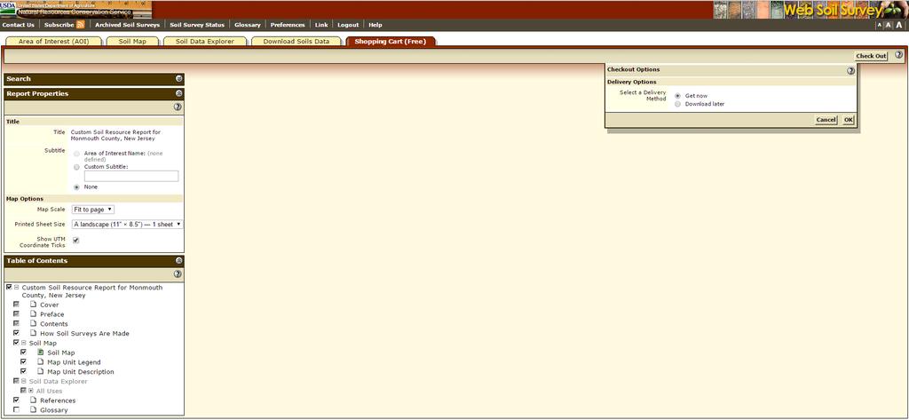
5 more than 50% chance of flooding in any year or more than 50 times in 100 years. We will not be reviewing highly technical aspects of hydric soils. Instead we will be covering three more easily understandable elements: 1. A list of hydric soils in New Jersey which can be found in Appendix B of this handout, coupled with the use of county soils surveys; 2. Common characteristics of organic hydric soils; 3. Common characteristics of mineral hydric soils. A great resource for identifying soils on a property is the USDA Web Soil Survey. With an address you can easily find out a great deal about the soil conditions on any site right at your computer. You can easily outline your area of interest and download a reasonably detailed site specific soil report for the property in question before you ever visit the site.

6 Start here with the above link:

7

8

9
10
11 Common Characteristics of Organic Hydric Soils Organic soils will typically be mucky or fibrous and very dark in color. When rubbed between your fingers, these organic soils will usually stain them nearly black. This is due to their high organic content. These soils will hold a great deal of moisture due to their high organic content. Due to their ability to retain high levels of moisture, these dark organic soils are often home to obligate wetlands plants, such as skunk cabbage and sedges. In general, organic soils have at least 6-18 inches of organic material in the upper portions of the soil profile. Organic soils generally form in depressional areas where large amounts of organic material, such as leaves, roots, stems, and other rotting plant material, accumulate. Anaerobic soil conditions occur during long periods of submergence and soil saturation during the growing season. Saturated conditions of this type impede aerobic decomposition of the material resulting in the formation of peat and muck. Depending on conditions, area and topography, these peat and muck deposits can range anywhere from 18 inches to more than 30 feet deep. Photos in Appendix-B depict typical organic soil conditions. Common Characteristics of Mineral Hydric Soils Mineral hydric soils have much lower accumulations of organic material in the soil. Some mineral soils may have a thick organic surface layer overlaying them. This is called a histic epipedon. This layer is typically 2 to 16 inches in depth and it is generally located at
12 or near the surface of a hydric mineral soil. This condition generally indicates that the mineral soil was saturated with water for 30 consecutive days or more over most years. This is a very good indicator that the mineral soil below it is hydric in nature. Hydric mineral soils can be somewhat more difficult to identify than the organic hydric soils. When trying to identify a mineral hydric soil, what we are looking for are indicators of redoximorphic conditions. In more simple terms, what this means is that iron and/or manganese oxides have been reduced by the wet conditions. Ferric oxide minerals give the red, yellow, brown or orange colors, which we are used to seeing in soils. Ferric and manganese oxides coat the surfaces of sand, silt and clay particles, giving soils the colors mentioned above. When these minerals are reduced by wet conditions, this coating is removed from the surface of these particles. This condition leaves the main color of the soil or matrix with a gray or what is also called a low chroma color.
 matrix color and a high chroma (yellow, brown, red or orange) color of the mottles.")
13 Example Munsell color chart: Another indicator formed by these reducing conditions are mottles. These mottles are easily distinguished from the low chroma (grayish) matrix color and a high chroma (yellow, brown, red or orange) color of the mottles. A good way to spot mottles in a soil horizon is to look for pockets of colors which look like those of a rusty nail. Essentially

14 what is going on in the formation of mottles is a similar chemical action. Another indicator of a hydric mineral soil is called gleying. A gleyed soil horizon is an indication of a very reduced soil. All gleyed soils are hydric soils. Gleyed soils are generally bluish, greenish or grayish in color and have had nearly all of the iron and manganese oxides reduced from them. I ll be showing a copy of the Munsell gleyed colors later on during this presentation. The gleying process can take place in both mottled and unmottled soils. Below is an example of gleyed colors.
15 Another good indication of a mineral hydric soil is the presence of what is called oxidized root zones. If this condition is present, you will notice rusty colored deposits around the roots of plants or around the root channels left along the root channels of decomposed roots. The chief thing to keep in mind when trying to identify a hydric mineral soil is that the main color of the soil (matrix) will tend to be grayish and mottles ranging from a yellowish to a dark brown will be present within 18 inches of the surface. If these two conditions are present, it is very likely that you are looking at a hydric soil and, therefore, likely in a wetland. Photos of mineral hydric soil indicators can be found in Appendix-B c) Wetlands hydrology The driving force in the formation of wetlands is wetlands hydrology. Simply put, this is the mechanism by which a wetland is supplied with inundation or soil saturation for the necessary time (usually a week or more) during the growing season. This inundation or saturation of soils can be provided by periodic flooding along a river, lake, stream or estuary, or by being part of a surface water drainage way. The wetness of any area is influenced by several factors. These can include precipitation, topography, soil permeability and plant cover. The frequency and duration of inundation or soil saturation play a significant role in wetland hydrology and the formation of wetlands. The duration of an inundation is usually considered to be the more important
16 factor of the two. This is illustrated when we look at areas of lower elevation within a flood plain or other areas subject to periodic inundation. When flooded, these areas will remain wet for longer periods of time than those areas which are of a higher elevation. Also, such areas are subject to more frequent events of flooding than those areas of a higher elevation. Very simply put, water runs downhill. Soil permeability and groundwater depth also contribute to the duration of inundation and soil saturation. Clayey soils absorb water at a much slower rate than sandy or sandy loam soils. Therefore, a soil with a higher clay content will remain saturated for a significantly longer period of time than a soil with a higher sand content. Regardless of the type of soil, a high water table (generally 1.5 feet or less from the surface) will contribute to wetlands hydrology being present. Areas with thick and abundant plant cover will tend to increase the duration of inundation or soil saturation in an area and thus, contribute to wetlands hydrology in that area. It should be noted, however, that plant cover can work in the opposite direction as transpiration rates can tend to be higher in areas of abundant plant cover and may actually reduce the duration of soil saturation. All of these varying conditions will contribute to a positive wetland hydrology. When trying to determine whether wetland hydrology is present on a site prior to a field visit, it is very useful to review any topographic survey data and aerial photography available. Also a review of any
17 wetland maps, flood maps, flood data or other hydrologic data that is available is quite useful. When reviewing topographic data available, we should be looking for depressional areas and low flat areas along any streams, rivers, or other bodies of water which may be associated with a flood plain. When reviewing aerial photography, it is best to review photography taken during the early spring. This will allow the direct observation of areas which are flooded or ponded. State and Federal wetlands mapping, which are readily available on line, will identify areas currently mapped as wetlands but are subject to field verification. Field indicators can be observed by visual observation on-site. These would include the following: 1. Visual observation of inundation. Obviously, if we visit our site and observe a ponded area during the growing season or a swampy area, it would be obvious to us that this particular location is wet. 2. Visual observation of soil saturation. This is accomplished by walking over a site and observing any areas which are soggy or mucky underfoot. Beyond this, soil borings are required to a depth of 18 to 24 inches. This will allow us to observe any standing groundwater. Also, observations would be made at the soil boring regarding soil color and depth to mottles. Soils should also be examined for saturation by squeezing them. If water can be
18 squeezed out of a soil sample taken within 18 inches of the surface, it should be considered saturated at that depth. 3. Oxidized root channels. Oxidized root channels, previously mentioned in the hydric soils section of this course, should also be noted during the soil boring. Once again, these are the iron concentrations (dark orangish or reddish brown) which form along the channels of roots. 4. Water marks. Water marks are found on the trunks of trees and other woody vegetation. These will be seen as stains on bark or other fixed objects such as a fence post. 5. Drift lines. These can be found adjacent to streams, other water courses or along the edges of tidal marshes. Drift lines are deposits of debris which become tangled with vegetation, trees or other fixed objects. Debris will consist of litter, vegetation remains or sediment and will be deposited generally parallel to the direction of water flow. Drift lines are an indication of the minimum extent of a flooding event. The maximum extent of flooding is generally beyond the drift line. 6. Waterborne sediment deposits. Waterborne sediment deposits are usually thin layers or coatings of mineral or organic matter which is left behind on plant surfaces or other vertical objects. A good example of this would be when the water recedes from a flooded area leaving an algae coating on the base of plants.
19 7. Water stained leaves. These will be found in forested wetlands which have been inundated for a significant period of time. These leaves will usually be blackish or grayish in color. 8. Surface scoured areas. This occurs along flood plains where flooding erodes sediments at the bases of trees leaving areas where no leaf litter is present as it has been washed away by the flooding conditions. 9. Wetland drainage patterns. These are visually observed as meandering or braided drainage patterns throughout an area, i.e., channels. 10. Morphological plant adaptations. These are adaptations which the plant life in an area has made in response to the inundation or soil saturation on-site. Good examples of these are shallow roots, buttress tree trunks, and multiple tree trunks. 11. Hydric soil characteristics. The hydric soil characteristics were previously discussed. Any or all of these field indicators of hydrology may be present on a given site. However, the most easily observable signs of wetland hydrology will be visual observation of low topography, surface water, wetland drainage patterns and the morphological plant adaptations mentioned previously. Photos of examples wetland hydrology field indicators can be found in Appendix-C
20 How are the Extents of the Wetlands Determined and Measured? The extents of wetlands on a given site are usually determined by an environmentalist and then field located and mapped by a licensed land surveyor. To first determine the extents of wetlands on a project, the environmentalist will utilize two procedures. First the off-site procedure, and second, on-site procedures. Before visiting the site and conducting any on-site procedures, the environmentalist would first review all available published data which might indicate the presence of wetlands on the subject site. This would include U.S.G.S. Maps, available State and Federal Wetlands Mapping, soil survey maps, recent aerial photography, and any available site specific information, such as a topographic survey map. If there is a prior Environmental Impact Statement available for the site, this would also be very useful. One of the most useful tools in determining the potential presence of wetlands on a site is the NJDEP NJ-GeoWeb located at: spx?theme=sapphire&uh=true&ridz= This mapping tool provides an easy view of those areas on your site that the NJDEP has map as wetlands along with a wide variety of other environmental information. Start here with the above web address:

21
22

23
24

25
26 Once all available data has been reviewed, the environmentalist will decide what areas on-site will be the most likely candidates for the presence of wetlands. The environmentalist will carry out an on-site delineation of the wetlands limits utilizing the three parameters of hydrophytic vegetation, hydric soils and wetland hydrology are used in order to flag a line between wetlands and uplands areas of the site. Whether using a tax map or an existing outbound survey, the environmentalist will begin in an obvious wetland area. At this sampling point, data will be collected on the plant community, wetland hydrology along with soil boring data. Once this data point has been established to be within a wetland community, the environmentalist will pick another sampling point in an obvious upland plant community as close as possible to the wetland community. The same data will be collected at the upland data point making a positive identification of that point as an upland. Once a positive wetland point and upland point have been established, the environmentalist will evaluate soils and vegetation between the two and flag a point somewhere in-between delineating the wetland boundary. This procedure is repeated across the entire length of the project to a point where the wetland line either leaves the property or closes on itself. This procedure is generally carried out at approximately 500 foot intervals along the length of the wetland boundary. These sampling points may be stretched out or brought closer together depending upon the existing field conditions. On relatively smooth lines flags are tied every 60 feet. When the wetlands line becomes more meandering, it will be necessary to tie flags much closer together or even use lath to mark the wetland line. Once the environmentalist s work is complete and the wetlands line has been
27 flagged in the field, the measurement of this line is undertaken by a land surveyor. The surveyor must locate all wetlands flags along the along with all boring locations. This information is then transferred to a topographic survey map which will eventually be used for an application to the NJDEP for a Regulatory Line Verification L.O.I. or wetlands permitting. Once the mapping has been approved through the Letter of Interpretation issued by the NJDEP, the wetlands line and/or buffer associated with it can be described as a metes and bounds and shown on future plans. Many municipalities in the State of New Jersey now require that the wetlands limits and its associated buffer be shown on final plats. Additionally, some municipalities are requiring that the wetland line itself or the buffer line be staked with iron pins and caps, such as Freehold Township in Monmouth County to reflect the position of the wetlands line physically in the field as approved by the NJDEP. Holmdel Township in Monmouth County takes this a step farther and requires that the buffer line itself be monumented along its metes and bounds with monuments reflecting that this is a conservation line. Who Has Jurisdiction Over Wetlands in New Jersey? The State of New Jersey has jurisdiction over freshwater wetlands within the State of New Jersey. This is under the authority of the Federal Clean Water Act Section 404. On March 2, 1994, the State of New Jersey assumed the administration of the 404 program for New Jersey with some variations. Those being that any major discharge would require a joint Federal, State review and wetlands within 1,000 feet of tidal waters are not assumable and are under the oversight of the
28 USEPA (Section 10 of Rivers and Harbors Act). The Pinelands Commission has stricter and somewhat modified regulations within their jurisdictional borders. Areas that are exempt from the Freshwater Protection Act in New Jersey are those waters as follows: Coastal wetlands under the Wetlands Act of HMDC jurisdiction (Hackensack Meadowlands). As outlined above, all wetlands within the State of New Jersey, other than the exception of the coastal wetlands and the Hackensack Meadowlands, are under the jurisdiction of the State of New Jersey. As such, the State regulates most activities that take place within them. There are very few activities which are not regulated within wetlands. They are as follows: 1. Surveying or wetlands investigation activities, for the purpose of establishing or reestablishing a boundary line or points, which use only hand held equipment and do not involve the use of motorized vehicles to either clear vegetation or extract soil borings. The clearing of vegetation along the survey line or around the survey points will not exceed three feet in width or diameter respectively and will not be kept clear or maintained once the survey or delineation is completed; 2. The placement of temporary structures (such as observation blinds, waterfowl blinds, artificial nesting structures, or sign posts) for observing, managing, or harvesting fish or wildlife, provided the structures:
29 i. Do not have permanent foundations; ii. Do not require the deposition of fill material; and iii. Have a footprint no larger than 32 square feet; 3. Placement of one or more small guy anchors that screw into the ground to secure a guy wire supporting a utility pole, provided that the area of disturbance caused by each guy anchor is no more than 15 inches in diameter; 4. Hand trimming of trees or other vegetation, provided the trimming does not alter the character of the freshwater wetland; and 5. The driving of one or more pilings in a State open water, if the pilings are not regulated by the ACOE under the Federal 404 program. The ACOE regulates the placement of pilings if the placement would have the effect of a discharge of fill material. Examples of activities that are and are not regulated by the ACOE are: i. Activities that generally do not have the effect of a discharge of fill material and thus are not regulated are: (A) Placing pilings for linear projects, such as bridges, elevated walkways, and utility line structures; and (B) Placement of pilings for piers or docks; ii. Activities that generally do have the effect of a discharge of fill material and thus are regulated include, but are not limited to:
30 (A) Projects where the pilings are so closely spaced that sedimentation rates would be increased; (B) Projects in which the pilings themselves effectively would replace the bottom of a water body; (C) Projects involving the placement of pilings that would reduce the reach or impair the flow or circulation of waters of the United States; (D) Projects involving the placement of pilings which would result in the adverse alteration or elimination of aquatic functions; and (E) Projects where the pilings are intended to be used for structural support of a building such as a commercial or residential structure. Regulated activities include the following: 1. The removal, excavation, disturbance or dredging of soil, sand, gravel, or aggregate material of any kind; 2. The drainage or disturbance of the water level or water table so as to alter the existing elevation of groundwater or surface water, regardless of the duration of such alteration, by: i. Adding or impounding a sufficient quantity of stormwater or other water to modify the existing vegetation, values or functions of the wetland; or ii. Draining, ditching or otherwise causing the depletion of the existing groundwater or surface water so as to modify the existing vegetation, values or functions of the wetland;
31 3. The dumping, discharging or filling with any materials; 4. The driving of pilings; 5. The placing of obstructions, including depositing, constructing, installing or otherwise situating any obstacle which will affect the values or functions of a freshwater wetland; and 6. The destruction of plant life which would alter the character of a freshwater wetland, including killing vegetation by applying herbicides or by other means, the physical removal of wetland vegetation, and/or the cutting of trees. Wetlands transition areas (buffers) are regulated similarly to the wetlands as described above. However, permitting rules regulating activities in a transition area are somewhat less stringent than in a wetland. As you can see, the limits placed on land use by regulation of the activities in and around wetlands are extensive. Proceed with caution when undertaking any activity in or around a wetland. How the Wetlands & Buffers Can Impact Your Project Limiting the usable lot area. Limiting access to portions of the site.
32 Limiting the use of a site. Limiting the Usable Lot Area Once a wetlands limits has been identified, delineated and approved by the NJDEP on a site, most activities in or near the wetlands will be regulated by the NJDEP under the rules and regulations adopted in the Freshwater Wetlands Protection Act N.J.A.C. 7:7A. As previously discussed, almost any construction activity is prohibited within the wetlands area without a permit. In some cases, all construction activity would be prohibited within the wetlands area. For instance, if a 200 x 200 lot with a continuous wetland line running through the rear half of the property, with a 100 foot width along with a 50 foot buffer, the usable area on the lot would now be reduced to a 200 x 50 strip along the front portion of the lot. If this situation were reversed and the wetlands began at the road and extended 100 feet into the property, this would require the use of not only a Transition Area Waiver, but a General Permit for crossing the wetlands in order to access the remaining portion in the rear of the property. If the same site had wetlands that were judged to be of exceptional resource value, it would then have a 150 foot wetlands buffer. In essence, this would make the entire lot unbuildable unless the owner was granted an Individual Permit. Limiting Access to Portions of the Site Another problem that can arise from the presence of wetlands on a site is the limiting of access to portions of the site. If a band of wetlands, a ditch or a swale located near or along the front portion of a site, access to any of the upland portions beyond the wetlands, will necessitate the use of some type of permit. When the width of a wetland area exceeds 100 feet, access to uplands located beyond the wetlands limits becomes more limited. Once the upland, which one wishes to gain access to, is separated from the roadway or other upland by a distance of 100 feet or more, access under a general permit may could mitigation which can be quite expensive. The NJDEP now requires 1:1 mitigation on certain General Permits.
33 Limiting Use of the Site Wetlands and their buffers can also limit the use of the site. An example of this would be if a client were to purchase a large farm with the hope of developing most of the fields and open areas. After making a wetlands investigation, it s entirely possible that a very large percentage of the fields may be found to be wetlands. As an ongoing farm which would be eligible for a farmland tax assessment, it would be exempt from the requirement for Freshwater Wetlands Permits provided normal farming activities, such as silvaculture, ranching, plowing, seeding, cultivating or harvesting of food or other crops, were being carried out. However, once the farming activity ceased or another activity began to take place in the areas previously farmed, these activities would then be subject to all wetlands regulations. Wetlands and their associated buffers can have considerable impacts on a property by limiting the usable lot area, limiting the access to portions of the site and by limiting the very use of the site. Now that we have identified ways that the wetlands boundaries and buffers can impact the use of a site, we will look at some ways that we can reduce these impacts by utilizing Letters of Interpretation (L.O.I.) General Permits and buffer reduction. Using L.O.I.s to Reduce Wetlands Impacts on Property The NJDEP issues three different types of L.O.I.s. These can be very useful when determining what can be done with a piece of property. They are as follows: 1. Wetlands Presence/Absence L.O.I. A wetlands presence/absence determination is the simplest level of L.O.I. The NJDEP will determine whether or not any freshwater wetlands, State open waters or transition areas (regulated Features) exist on a site or a portion of a site (Footprint of Disturbance) and provide resource value classification of freshwater wetlands and transition areas. The wetlands presence/absence L.O.I. will not determine the location of any wetlands on a given site, but will only state whether a regulated feature exists. The NJDEP will issue a presence/absence L.O.I. for a site of any size. The NJDEP will issue a presence/absence L.O.I. for a
34 portion of a site (Footprint of Disturbance). The NJDEP limits the size of a Footprint of Disturbance to no larger than 1 acre and will approve a maximum of three Footprints of Disturbance on a site Prior to a State inspection for a footprint of disturbance, it is necessary to have all limits of disturbance flagged in the field, numbered and the flagged limits of disturbance shown on an outbound survey. Obviously a wetlands presence/absence L.O.I. is of limited use. This type of L.O.I. is most useful in cases where it is nearly a certainty that no wetlands are present at the location where improvements would take place and an official State document supporting this is desirable to obtain. 2. A delineation under an acre L.O.I. For smaller parcels of an acre or less, the NJDEP will provide an on-site delineation and a letter of interpretation defining the limits of any wetlands, State open water or transition areas present on a site of one acre or less. This method can be quite useful when dealing with an individual building lot of an acre or less which may have wetlands located on-site. With this type of L.O.I., the State provides all field work necessary to flag the wetlands on-site. This line as flagged by the NJDEP would then have to be field surveyed and shown on any subsequent plot plan and/or survey of the property. 3. Regulatory line verification. Regulatory line verification This is the type of L.O.I. which would be used for larger tracts of land containing wetlands, State open water or transition areas. It is required that all wetlands lines be field delineated using the three parameter approach, flagged, numbered, field located and be shown on an outbound survey plan or site plan of the property. If the site is located in Mercer or Middlesex County or north of these counties, the survey must include topography depicting
35 contours at no greater than 5 foot intervals. For counties south of Middlesex and Mercer, the survey must include topography depicting, at a minimum, 2 foot contours. The delineated line will be inspected by the NJDEP, who may recommend repositioning of some of the flagged points. Once any adjustments to the flagged wetlands line are completed, they should be relocated and revised accordingly on all plans. A revised survey should then be resubmitted to the NJDEP. It will be referenced in the L.O.I. All subsequent plans should reflect the date of the approved L.O.I. along with NJDEP file numbers. This type of L.O.I. is useful in planning what portion of a site can be improved. Development of a buffer averaging plan would also require this information. What Determines the Resource Value of a Wetland? Per the Freshwater Wetlands Protection Act, freshwater wetlands are divided into three classifications based on their resource value. The first is freshwater wetlands of an exceptional resource value which are all those wetlands that exhibit any of the following characteristics. 1) All those wetlands that discharge into FW1 or FW2 trout production waters or their tributaries; or 2) those wetlands which are present habitats for threatened or endangered species or those which are documented habitats for threatened or endangered species and which remain suitable for breeding, resting or feeding by these species during the normal period which these species would use the habitat. The second resource value which can be designated to a freshwater wetland is that of ordinary resource value. These are freshwater wetlands which do not exhibit the characteristics outlined above and which are:
36 1. Isolated wetlands which are more than 50% surrounded by development and less than 5,000 square feet in size. For the purpose of clarification, the term development is defined as the following uses which were legally existing prior to July 1, 1988 or were permitted under the Act: a. lawns b. maintained landscaping c. impervious surfaces d. active railroad rights-of-way e. graveled or stoned parking/storage areas and roads. Further, this development must occupy more than 50% of the area within 50 feet of the wetland boundary in order for the wetland to meet the criteria of more than 50% surrounded by development. 2. Drainage ditches 3. Swales 4. Detention facilities. The third and most common freshwater wetlands resource value designation is that of intermediate resource value. This designation is given to all freshwater wetlands not defined as exceptional or ordinary. Using Wetlands Permits to Reduce Wetlands Impacts on Property There are several General Permits available from the NJDEP for various activities in and around wetlands. Most of these wetlands permits also apply to the same activities with wetland transition areas. Five of the more common permits are covered to demonstrate their use on a property that has wetlands
37 located on same but can be useful in construction of improvements. They are as follows: 1. A General Permit #1 Maintenance and repair of existing features 2. A General Permit #6 for filling of Isolated wetlands. 3. A General Permit #7 for filling of Ditches and swales. 4. A General Permit #8 for House additions 5. A General Permit #10A or #10B for Minor road crossings. General Permit # 1 A General Permit # 1 allows for activities in freshwater wetlands and State open waters, required for the repair, rehabilitation, replacement, maintenance or reconstruction of a previously authorized, currently serviceable structure, fill, roadway, utility line, active irrigation or drainage ditch, or stormwater management facility lawfully existing prior to July 1, This permit is very helpful in cases where a wetland area was filled and built on legally but is failing or becoming a wetland again over time. While there is no acreage limit on disturbance with this permit there are some restrictions. The previously authorized use cannot change from the use that was previously approved. Also there can be no expansion of the use. General Permit # 6 A General Permit #6 can be useful in land development. One must keep in mind that this permit now requires 1:1 mitigation for permanent loss and/or disturbance of less than 0.1 acres of freshwater wetlands or State open waters that are also waters of the United States unless the applicant demonstrates to the Department that all activities have been designed to avoid and minimize impacts to wetlands. From the NJDEP s point of view, minimize means that the project is configured so that most or all of it is contained in the uplands on the site, and that the wetlands are avoided to the greatest extent possible. An applicant is not required to reduce the scope of the project or to consider offsite alternatives to comply with this requirement. This permit allows for fill of up to one acre in any isolated wetlands, with some conditions. The definition of an isolated wetland is any wetland that is not part of a surface water tributary. To define this further, this type of wetland must be completely cut off by uplands from any other wetland body. This connection
38 would include any type of ditch, swale, channel or even a piped connection to another water course or wetlands body. Therefore, even if there were only a small piece of wetlands on your property but was connected by 2,000 feet of pipe to a ditch downstream, it would not be considered an isolated wetland. With the term isolated wetland properly defined, here is a review of some of the standards which must be adhered to in order to comply with the conditions of the General Permit #6. One of the most important things to consider when applying for a fill permit is to demonstrate that the fill is project related. An example of a project related fill would be the construction of a structure or impervious surface over the isolated wetland or grading necessary to the particular construction activity. Merely filling the wetland in order to do away with it, would not be acceptable. Other approval standards which must be considered when applying for a General Permit #6 require that the isolated wetland to be filled not be classified as either USEPA priority wetlands, State open water that is a special aquatic site, State open water that is larger than one acre or wetlands of exceptional resource value. If the isolated wetland in question has been assigned either of the above mentioned designations, a General Permit #6 is prohibited. Also, as previously mentioned, the wetland fill cannot exceed one acre. Ideally it should be less than one acre. General Permit # 7 A General Permit #7 allows for the filling of a ditch of human construction or swales in a headwater. The restrictions of this permit are very similar to those for the General Permit #6 described above. In addition to the approval standards of being project related, fill less than an acre, not of exceptional resource value, not EPA priority, the following additional items must be considered. They are as follows: 1. The ditch or swale to be filled must be located in the headwater area of the ditch or swale. "Headwater" means a water or wetland that is upstream of the point on a non-tidal stream where the average annual flow is less than five cubic feet per second and a drainage area of less than 50 acres. 2. The proposed activity will not result in a disruption of a surface water connection and the isolation of adjacent wetlands or State open waters.
39 General Permit # 8 A General Permit # 8 allows for the construction of additions or appurtenant improvements to residential dwellings lawfully existing prior to July 1, 1988, provided that the improvements or additions require less than a cumulative surface area of 750 square feet of fill and/or disturbance and will not result in new alterations to a freshwater wetlands outside of the 750 square foot area. This permit can also be used in conjunction with the replacement a legally existing dwelling (built prior to July 1, 1988) to provide an expansion of the original footprint or a garage. The main restrictions with this permit are: 1. No more than a total 750 SF 2. Proof of position the lawful existence prior to July 1, Improvements must be within 100 of the residential dwelling General Permit # 10A & 10B A General Permit #10A allows for very minor road crossings of wetlands or transition areas as follows: 1. Construction of one or more new road crossings, including attendant features such as shoulders, sidewalks and embankments; 2. Expansion, widening, or upgrading of one or more existing paved or unpaved roads or drives; and 3. Activities necessary to reduce horizontal curves in an existing paved road to comply with New Jersey Department of Transportation safety regulations. The NJDEP will issue a general permit 10A authorization only if the activities comply with the limits in one of the following scenarios: 1. Short crossing scenario: i. The disturbance of freshwater wetlands and/or State open waters is no longer than 100 feet for each crossing, as calculated under (e) below; and ii. The total cumulative disturbance of freshwater wetlands, transition area, and State open waters onsite under general permit 10A is one quarter acre or less; or 2. Long crossing scenario: The total cumulative disturbance of freshwater wetlands, transition area, and State open waters onsite under general permit 10A is one eighth acre or less. Under the long crossing scenario, the length of the crossing is not limited.
40 If a proposed road crossing skirts along the edge of a wetland or transition area or touches the wetland or transition area, without actually crossing through the wetland or transition area, the applicant will, in addition to meeting the requirements at (b) above, demonstrate in accordance with N.J.A.C. 7:7A-5.10B (d) that there is no alternative onsite location and/or configuration for the road crossing that would provide access to the developable upland with less adverse environmental impact. All activities under general permit 10A must minimize environmental impact as follows: 1. The applicant will design the crossing to ensure that fish passage is unimpeded during times when the water level is at its lowest, unless the applicant demonstrates that the water body is unsuitable for habitation by fish and will remain so for the foreseeable future. The applicant will ensure fish passage by maintaining the existing gradient and bottom contours of the water body to the extent possible, and by using arches, culverts, or other structures that will ensure fish passage; 2. The applicant will install cross drains or other devices to ensure that the crossing does not alter the hydrology of the freshwater wetlands and/or State open waters on either side of the crossing; and 3. The amount of rip-rap or other energy dissipating material used will be the minimum necessary to prevent erosion, and will not exceed 200 cubic yards of fill below the top of bank or high water mark, unless a larger amount is required in order to comply with the Standards for Soil Erosion and Sediment Control in New Jersey. Mitigation will be performed for all permanent loss and/or disturbance of 0.1 acres or greater of freshwater wetlands or State open waters. Below are two examples of acceptable General Permit 10A crossing scenarios.
41
42 A general Permit 10B is much the same as a 10A and has all of the same requirements but carries additional restrictions due to the fact that this permit has the potential for more environmental impact. These extra restrictions are outlined below: 1. The cartway, shoulder, and side slopes of the roadway shall be the minimum necessary for the crossing and shall not exceed the limits in the New Jersey Department of Community Affairs' Residential Site Improvement Standards at N.J.A.C. 5:21. If the project is not a residential development, the cartway, shoulder, and side slopes of the roadway shall be the minimum necessary for safety. 2. The applicant will be required to provide an alternative analysis of other possible on site locations for disturbance that would have lesser environmental impact to wetlands areas as follows: 1. Disturbance of a non-transition area upland would have less adverse environmental impact than disturbance of a transition area, State open water or freshwater wetland; 2. Disturbance of a transition area would have less adverse environmental impact than disturbance of a freshwater wetland or State open water; 3. Disturbance of a freshwater wetland would have less adverse environmental impact than disturbance of a State open water; 4. Expansion or upgrading of an existing and currently serviceable drive or crossing would have less adverse environmental impact than placement of a new crossing; and 5. Placement of a new crossing in an area that is already significantly disturbed would have less adverse environmental impact than disturbance of a previously undisturbed wetland and/or State open water. Once again this permit requires mitigation for total permanent disturbance once you have reached 0.1 acres of disturbance.
43 Making an application to the NJDEP This is an outline of the basic application requirements for any type of application to the NJDEP. 1. A completed LURP- form. This form must be filled out in its entirety. A brief description of the project is included on Page 1, which should include what type of L.O.I. or General Permit is being applied for along with a description of the disturbance. All signatures required on the LURP form will need to be addressed. This will include the current owner of the project, which may not be your client, along with the owner s unconditional consent for entry. 2. A USGS Quad Map showing the project in question. 3. New Jersey State Plane Coordinates for the center of the project (northing/easting). 4. Certified list of property owners within 200 of the site. 5. A copy of the written notice sent to all required recipients. (Wording is detailed within the Freshwater Wetlands Protection Act. ) 6. Proof of notification of all required recipients. 7. Fees as per N.J.A.C. 7:7A-16 for all application items. For an L.O.I. application additional items will be required as follows: A tax map with the property outlined. A location map (county map, Hagstrom map, or other local street map). A copy of the county soils survey map with the property outlined to scale. Photographs of the site. Photo location map showing numbered photos and the directions at which the photo was taken. ADDITIONAL REQUIREMENTS FOR DIFFERENT L.O.I.s PRESENCE/ABSENCE FOOTPRINT OF DISTURBANCE: Survey (scale of 1 = 50 or larger) showing the limits of all proposed footprint of disturbance on-site. (No more than 3-1 acre or less footprints per property)
44 The limits of each footprint of disturbance must be flagged on-site. DELINEATION UNDER AN ACRE: Outbound survey or site plan of the project. REGULATORY LINE VERIFICATION: Topographic survey with contours (two foot contours for Middlesex County or south, five foot contours for north of Middlesex County) showing the location of the wetlands line and all soil borings. Soil boring data sheets. Vegetative species data sheets. Wetland line must be flagged in the field with corresponding numbers shown on the topographic survey. Along with the above contents for a complete application package, a cover letter detailing the contents along with your calculation of the fee should be included. For a more comprehensive review of application package requirements review the L.O.I. Checklist included in Appendix-D. For a General Permit or Transition Area Waiver application additional items will be required as follows: Color photographs of the area to be disturbed. Site plan showing the following: a. All proposed activities and disturbances along with the areas of same. b. If no L.O.I. has been issued on the property, copies of soil data sheets and vegetation data sheets for the area to be disturbed must be included. c. For a General Permit application, the site plan must detail all items to be constructed along with any associated grading. d. For a buffer averaging plan, the site plan should clearly show the areas of all proposed transition area reductions along with all areas of proposed transition area compensation. The areas in square feet/acres be shown on both buffer reduction areas and buffer compensation areas. A statement of compliance detailing how all site related activities comply with the conditions of the particular General Permit or buffer reduction being applied for.
45 * It should be noted that in some municipalities within the State of New Jersey the application must include a signed statement from the applicant, certifying that the proposed activities will not result in any direct or indirect adverse impacts to swamp pink (helonias bullata) and/or bog turtles (Glyptemys muhlenbergii). BIBLIOGRAPHY: The following materials were used in the preparation of this course and handout. 1. Federal Manual for Identifying and Delineating Jurisdictional Wetlands. January Freshwater Wetlands Protection Act Rules N.J.A.C. 7:7A amended to February 2, Cook College Continuing Education: a. Course Materials: Freshwater Wetlands b. Course Materials: Vegetation Identification for Wetland Delineation, Southern Section. c. Course Materials: Methodology of Delineating Wetlands. 4. The Coordinate Winter 1989.
46 5. USDA Web Soil Survey NJDEP NJ-GeoWeb located at: apphire&uh=true&ridz=
Freshwater Wetland Rules and Agriculture NJDEP Freshwater Wetlands Rules N.J.A.C. 7:7A Effective 10/20/03
 Freshwater Wetland Rules and Agriculture NJDEP Freshwater Wetlands Rules N.J.A.C. 7:7A Effective 10/20/03 Normally, the NJDEP Freshwater Wetlands Rules (NJAC 7:7A-2.2) regulate any activities in and around
NJDEP Regulations that impact or soon will impact agricultural operations. April 1, 2007 Horses 2007
 NJDEP Regulations that impact or soon will impact agricultural operations. April 1, 2007 Horses 2007 Peter L. Kallin, Ph.D., P.W.S. Phone: 732-499-3600 Ext. 237 E-mail: pkallin@aesop.rutgers.edu www.water.rutgers.edu
Maine s Land Use Regulations and Erosion Control Techniques
 Maine s Land Use Regulations and Erosion Control Techniques Protecting Maine s Air, Land and Water Colin Clark 441-7419 colin.a.clark@maine.gov Tom Gilbert 441-8031 thomas.gilbert@maine.gov Jim Rodrigue
Appendix E Preliminary Jurisdictional Wetland Delineation Report, JYL 2008
 Appendix E Preliminary Jurisdictional Wetland Delineation Report, JYL 2008 PRELIMINARY JURISDICTIONAL WETLAND DELINEATION REPORT A portion of USS 3819 and 2664: Horton Lot and Statter Harbor Juneau, Alaska
What is a Wetland? Common Wetland Names. Wetlands: Ecotones between Upland and Aquatic Systems. Matthew J. Gray University of Tennessee.
 What is a Wetland? Matthew J. Gray University of Tennessee Common Wetland Names Backwater swamps Peatland Estuary Vernal Pools Marsh Playa Fen Bog Bayou Spring Seep Humedales Wetlands: Ecotones between
HYDRIC SOILS. By Neal Svendsen Resource Soil Scientist Natural Resources Conservation Service Sept 2006
 HYDRIC SOILS By Neal Svendsen Resource Soil Scientist Natural Resources Conservation Service Sept 2006 Wetlands and Hydric Soils The term hydric soils proposed by Cowardin in 1979 Classification of Wetlands
Ordinance No Lot Surface Drainage
 Ordinance No. 35-2008 - Lot Surface Drainage The Township has adopted a new Lot Surface Drainage Ordinance which amends Chapter 170, Article IX, Subdivision and Site Plan Review by adding a new Section
KRISTOPHER J. KRZYSTON, CEI, CEM
 PERMITTING IN NEW JERSEY KRISTOPHER J. KRZYSTON, CEI, CEM Kristopher J. Krzyston Rutgers graduate 1994 B.S. Environmental Planning Certificate in G.I.S. Assistant Division Manager Environmental Science
Wetland Delineation. Richard L. Darden, Ph.D. U.S. Army Corps of Engineers Charleston District October 3, 2012 BUILDING STRONG
 Wetland Delineation Richard L. Darden, Ph.D. U.S. Army Corps of Engineers Charleston District October 3, 2012 Why Delineate Wetlands? To define the limits of federal jurisdiction, in accordance with current
New Jersey Statewide Stormwater, Flood Hazard and Wetlands Programs
 New Jersey Statewide Stormwater, Flood Hazard and Wetlands Programs Authorities Federal Clean Water Act NJ Water Pollution Control Act NJ Stormwater Management Act Soil Erosion and Sediment Control Act
CHESAPEAKE BAY PRESERVATION AREA PROGRAM CHESAPEAKE BAY PRESERVATION AREAS
 6.1 OVERVIEW CHESAPEAKE BAY PRESERVATION AREAS Virginia s Chesapeake Bay Preservation Area Designation and Management Regulations (9VAC10-20 et seq.) require local governments to implement ordinances designed
I THOUGHT IT WAS JUST WET LAND: A GUIDE TO ENVIRONMENTAL PERMITTING FOR AIRPORTS ROAD SCHOOL 2018 SIMON DAVIES, SENIOR SCIENTIST MARCH 7, 2018
 I THOUGHT IT WAS JUST WET LAND: A GUIDE TO ENVIRONMENTAL PERMITTING FOR AIRPORTS ROAD SCHOOL 2018 SIMON DAVIES, SENIOR SCIENTIST MARCH 7, 2018 Definition Regulatory Definition - Those areas that are inundated
Phase II: Proposed (regulated) Impervious in disturbed area (ac) Long Lake Existing Impervious in disturbed area (ac)
 Impervious in disturbed area (ac) Long Lake Existing Impervious in disturbed area (ac)") Permit Application No.: 17-181 Rules: Erosion Control, Wetland Protection, and Waterbody Crossings & Structures Applicant: Hennepin County Received: 4/27/17 Project: CSAH 112 Phase II Complete: 9/5/17
Permit Application No.: 17-181 Rules: Erosion Control, Wetland Protection, and Waterbody Crossings & Structures Applicant: Hennepin County Received: 4/27/17 Project: CSAH 112 Phase II Complete: 9/5/17
GENERAL GUIDELINES FOR CONDUCTING THREATENED AND ENDANGERED SPECIES SURVEYS IN THE PINELANDS AREA. March 25, 2006 INTRODUCTION
 GENERAL GUIDELINES FOR CONDUCTING THREATENED AND ENDANGERED SPECIES SURVEYS IN THE PINELANDS AREA March 25, 2006 INTRODUCTION This document is intended to provide general guidance for use in conducting
Prepared by: Rummel, Klepper & Kahl
 WETLAND DELINEATION REPORT Kutztown Road (SR 1033) Resurfacing and Bridge Replacement Upper Hanover Township, Montgomery County, Pennsylvania Prepared for: PennDOT District 6-0 Prepared by: Rummel, Klepper
Wetlands. DuPage County Stormwater Ordinance Update- Wetlands and Buffers. Is a Stormwater Permit Required? 7/13/2012
 DuPage County Stormwater Ordinance Update- Wetlands and Buffers PRESENTED BY: MARY BETH FALSEY WETLAND SPECIALIST Wetlands Section 15-18.A.1.a: If a Stormwater Administrator has the expertise, he/she can
TOWN OF SMYRNA Water Quality Buffer Zone Policy
 TOWN OF SMYRNA Water Quality Buffer Zone Policy Section I - Description A water quality buffer zone (a.k.a. a riparian zone) is a strip of undisturbed native (indigenous) vegetation, either original or
CHARLES SOIL CONSERVATION DISTRICT COMPLIANCE AGREEMENT FOR THE STANDARD EROSION AND SEDIMENT CONTROL PLAN FOR FOREST HARVEST OPERATIONS
 CHARLES SOIL CONSERVATION DISTRICT COMPLIANCE AGREEMENT FOR THE STANDARD EROSION AND SEDIMENT CONTROL PLAN FOR FOREST HARVEST OPERATIONS I. Site Information A. Location (Include site map of harvest area)
Wetland Permit Application
 DAVID J. KLOTZLE WETLAND INSPECTOR, PHILIPSTOWN, NY 238 Main Street Cold Spring, NY 10516 (914) 736-7132 Wetland Permit Application MEMO TO APPLICANT 1. Use this form to apply for a Wetlands Permit as
FLOODPLAIN PERMIT APPLICATION SUBMITTAL REQUIREMENTS
 Planning Department 215 South 4 th Street, Suite F Hamilton, MT 59840 Phone 406-375-6530 Fax 406-375-6531 planning@rc.mt.gov FLOODPLAIN PERMIT APPLICATION SUBMITTAL REQUIREMENTS To initiate the permit
The Relationship between the Properties and Features of Wetland Soils and the Adjacent Uplands
 The Relationship between the Properties and Features of Wetland Soils and the Adjacent Uplands By USDA Natural Resources Conservation Service Connecticut Staff Wetlands and watercourses are features of
KANKAKEE COUNTY PLANNING DEPARTMENT APPLICATION FOR CLASS I & II GRADING AND DRAINAGE/STOMRWATER PERMIT APPLICATION
 KANKAKEE COUNTY PLANNING DEPARTMENT APPLICATION FOR CLASS I & II GRADING AND DRAINAGE/STOMRWATER PERMIT APPLICATION Michael J. Van Mill, AICP Planning Director 189 East Court Street Kankakee, IL 60901
Deep River-Portage Burns Waterway Watershed 2015
 2.4 Soils Soil development is the product of the interaction of parent material, topography, climate, organisms and time. Understanding the types of soils that exist within a watershed and their characteristics
Appendix C-3. Wetlands and Other Surface Waters Report
 Appendix C-3 Wetlands and Other Surface Waters Report WETLANDS AND OTHER SURFACE WATERS REPORT Hatchet Ridge Wind Energy Project Shasta County, California Prepared for: Hatchet Ridge Wind, LLC Portland,
S.R. 430, Segment 250 Offset 0000, Greenfield Township Wetland Delineation
 S.R. 430, Segment 250 Offset 0000, Greenfield Township Wetland Delineation Date: October 30, 2007 Re: To: From: Erie County SR 430 Segment 250 Offset 0000 Wetland Delineation Mr. Todd Palmer Bridge Unit
How to avoid getting bogged down by the Nova Scotia Wetland Conservation Policy
 How to avoid getting bogged down by the Nova Scotia Wetland Conservation Policy for the Environmental Services Association of Nova Scotia By Krista Hilchey Wetland Specialist, Nova Scotia Environment To
Stormwater Erosion Control & Post-Construction Plans (Stormwater Quality Plans)
") Stormwater Erosion Control & Post-Construction Plans (Stormwater Quality Plans) Allen County Stormwater Plan Submittal Checklist The following items must be provided when applying for an Allen County Stormwater
Stormwater Erosion Control & Post-Construction Plans (Stormwater Quality Plans) Allen County Stormwater Plan Submittal Checklist The following items must be provided when applying for an Allen County Stormwater
Stormwater Local Design Manual For Houston County, Georgia
 Stormwater Local Design Manual For Houston County, Georgia Adopted November 15, 2005 TABLE OF CONTENTS 1. FORWARD... 1 2. GENERAL LEVEL OF SERVICE STANDARDS... 2 2.1. DETENTION REQUIREMENTS... 2 2.1.1.
Plant, Wildlife and Wetland Assessment
 WSU Project Site Plant, Wildlife and Wetland Assessment approximately 38 acres of the site would be in retained natural area, including passive use portions of the park and smaller natural areas in other
HOUSE BILL lr0052
 M HOUSE BILL lr00 By: Chair, Environment and Transportation Committee (By Request Departmental Environment) Introduced and read first time: February, 0 Assigned to: Environment and Transportation Committee
Warner Robins Stormwater Local Design Manual
 Warner Robins Stormwater Local Design Manual Prepared for Houston County City of Warner Robins City of Perry City of Centerville May 17, 2005 Version 4 (As presented with adopted Stormwater Ordinance)
CITY OF SPRING HILL Water Quality Buffer Zone Policy (Adopted April 22, 2008)
") Section I - Description CITY OF SPRING HILL Water Quality Buffer Zone Policy (Adopted April 22, 2008) A water quality buffer zone (a.k.a. a riparian zone) is a strip of undisturbed native (indigenous)
Section I - Description CITY OF SPRING HILL Water Quality Buffer Zone Policy (Adopted April 22, 2008) A water quality buffer zone (a.k.a. a riparian zone) is a strip of undisturbed native (indigenous)
Routine Wetland Determination
 Project/Site: 60-0008-0560-0032 Applicant/owner: PENNDOT, Eng. District 1-0 Investigator(s): Christopher R. Wolfgong Routine Wetland Determination DATA FORM 1 (Revised) 1987 Corps Wetland Delineation Manual)
REQUIRED INFORMATION Please check the following boxes that apply to your lot or parcel and complete the other requested information.
 MARTIN COUNTY EXCAVATION AND FILL PERMIT APPLICATION This application to be used only for excavating or filling activities not associated with a building permit or development review and for projects requiring
STANDARD GRADING AND SOIL EROSION & SEDIMENT CONTROL PLAN FOR SINGLE LOT SINGLE FAMILY RESIDENTIAL CONSTRUCTION AND MINOR EARTH DISTURBANCES
 DIVISION OF ENGINEERING & CONSTRUCTION MANAGEMENT PLAN REVIEW DEPARTMENT WASHINGTON COUNTY SOIL CONSERVATION DISTRICT 1260 Maryland Avenue, Suite 101 Hagerstown, MD 21740 Telephone: (301) 797-6821, Ext.
Surface Water and Non-Wetland Surface Waters Delineation and Classification pursuant Chapter F.A.C.
 Surface Water and Non-Wetland Surface Waters Delineation and Classification pursuant Chapter 62-340 F.A.C. What are Waters? 373.019 F.S. Definitions (20) Water or waters in the state means any and all
PROSPECTUS. Proposed Beech River Canal Wetland and Stream Mitigation Bank
 PROSPECTUS Proposed Beech River Canal Wetland and Stream Mitigation Bank INTRODUCTION This prospectus provides an overview of Beech River Farms, LLC s (BRF) proposed Beech River Canal Wetland and Stream
SECTION 12 STANDARDS FOR CONSTRUCTION PLANS AND SPECIFICATIONS
 SECTION 12 STANDARDS FOR CONSTRUCTION PLANS AND SPECIFICATIONS 12.1 The subdivider shall construct and install the improvements in accordance with the County's Standards for Construction Plans and Specifications
BLOCKING AND FILLING SURFACE DRAINAGE DITCHES
 MINNESOTA WETLAND RESTORATION GUIDE BLOCKING AND FILLING SURFACE DRAINAGE DITCHES TECHNICAL GUIDANCE DOCUMENT Document No.: WRG 4A-1 Publication Date: 10/14/2015 Table of Contents Introduction Application
CONSTRUCTION PLAN CHECKLIST
 CONSTRUCTION PLAN CHECKLIST The design engineer is responsible for ensuring that plans submitted for city review are in accordance with this checklist. It is requested that the executed checklist be submitted
MINNEHAHA CREEK WATERSHED DISTRICT BOARD OF MANAGERS REVISIONS PURSUANT TO MINNESOTA STATUTES 103D.341. Adopted April 24, 2014 Effective June 6, 2014
 MINNEHAHA CREEK WATERSHED DISTRICT BOARD OF MANAGERS REVISIONS PURSUANT TO MINNESOTA STATUTES 103D.341 Adopted April 24, 2014 Effective June 6, 2014 EROSION CONTROL RULE 1. POLICY. It is the policy of
Municipal Stormwater Management Plan Prepared For The Borough of Cape May Point By Van Note-Harvey Associates VNH File No.
 Municipal Stormwater Management Plan Prepared For The Borough of Cape May Point By Van Note-Harvey Associates 2005 VNH File No. 35317-210-21 Table of Contents Introduction... 3 Goals... 3 Storm water Discussion...
CCSD#1 Stormwater Standards
 SECTION 6 EROSION CONTROL STANDARDS 6.1 INTRODUCTION The policies of this section shall apply during construction and until permanent measures are in place following construction as described herein, unless
Legal Perspectives on Florida Wetland Jurisdiction
 Legal Perspectives on Florida Wetland Jurisdiction Timothy J. Perry, Esq. Oertel, Fernandez, Bryant & Atkinson, P.A. Tallahassee, Florida tperry@ohfc.com History 1993 Florida Environmental Reorganization
BUILDING PERMIT CHECKLIST FOR THE TOWN OF GRAND LAKE
 BUILDING PERMIT CHECKLIST FOR THE TOWN OF GRAND LAKE Please Note: No construction, including site preparation (grading, excavating, vegetation removal, etc.), will be allowed until a building permit or
RIPARIAN AREAS REGULATION
 Definitions and interpretation RIPARIAN AREAS REGULATION 1 (1) In this regulation: Act means the Fish Protection Act; active floodplain means an area of land that supports floodplain plant species and
MODEL Stormwater Local Design Manual. City of Centerville
 MODEL Stormwater Local Design Manual City of Centerville Adopted December 6, 2005 TABLE OF CONTENTS 1. FORWARD... 1 2. GENERAL LEVEL OF SERVICE STANDARDS... 1 2.1. DETENTION REQUIREMENTS... 1 2.1.1. Discharge
LAKE COUNTY HYDROLOGY DESIGN STANDARDS
 LAKE COUNTY HYDROLOGY DESIGN STANDARDS Lake County Department of Public Works Water Resources Division 255 N. Forbes Street Lakeport, CA 95453 (707)263-2341 Adopted June 22, 1999 These Standards provide
SECTION 10: WETLANDS PROTECTION
 SECTION 10: WETLANDS PROTECTION 10-1 INTENT AND PURPOSE A. Intent 1. The City finds that wetlands serve a variety of beneficial functions. Wetlands maintain water quality, reduce flooding and erosion,
APPENDIX I. Plan Reviewer Checklist
 APPENDIX I Plan Reviewer Checklist PLAN REVIEW CHECKLIST Annual Standards and Specifications The ESC/SWM Plan clearly indicates the version of Virginia Tech Annual Standards and Specifications applicable.
NEW CASTLE CONSERVATION DISTRICT. through. (Name of Municipality) PLAN REVIEW APPLICATION DRAINAGE, STORMWATER MANAGEMENT, EROSION & SEDIMENT CONTROL
 PLAN REVIEW APPLICATION DRAINAGE, STORMWATER MANAGEMENT, EROSION & SEDIMENT CONTROL") NEW CASTLE CONSERVATION DISTRICT through (Name of Municipality) PLAN REVIEW APPLICATION DRAINAGE, STORMWATER MANAGEMENT, EROSION & SEDIMENT CONTROL Office use only: Received by Municipality: Received by
NEW CASTLE CONSERVATION DISTRICT through (Name of Municipality) PLAN REVIEW APPLICATION DRAINAGE, STORMWATER MANAGEMENT, EROSION & SEDIMENT CONTROL Office use only: Received by Municipality: Received by
An Introduction to the Corps of Engineers Regulatory Program
 An Introduction to the Corps of Engineers Regulatory Program Kathleen Buckler Biologist/Project Manager Regulatory Branch NY Permit Evaluation Section Kathleen.a.buckler@usace.army.mil US Army Corps of
ZONING ORDINANCE FOR THE ZONED UNINCORPORATED AREAS ARTICLE 1500 OF PUTNAM COUNTY, WEST VIRGINIA Page 149 ARTICLE 1500 DRAINAGE AND STORM SEWERS
 OF PUTNAM COUNTY, WEST VIRGINIA Page 149 ARTICLE 1500 DRAINAGE AND STORM SEWERS 1500.01 GENERAL REQUIREMENTS 1500.02 NATURE OF STORM WATER FACILITIES 1500.03 DRAINAGE EASEMENTS 1500.04 STORM WATER MANAGEMENT
WELCOME ASSESSING ENVIRONMENTAL IMPACTS: CONSIDERING STATE REGULATIONS IN SITE PLAN REVIEW
 WELCOME ASSESSING ENVIRONMENTAL IMPACTS: CONSIDERING STATE REGULATIONS IN SITE PLAN REVIEW CONSIDERING STATE REGULATIONS IN SITE PLAN REVIEW ASSOCIATION OF NEW JERSEY ENVIRONMENTAL COMMISSIONS MARCH 30,
GRADING & DRAINAGE PERMIT SOIL EROSION AND SEDIMENTATION CONTROL PERMIT PROGRAM OVERVIEW
 GRADING & DRAINAGE PERMIT SOIL EROSION AND SEDIMENTATION CONTROL PERMIT PROGRAM OVERVIEW Chapter 8 Building and Building Regulations, Article XIII Grading and Drainage and Article XV Soil Erosion and Sedimentation
CATEGORY a protection of the natural environment, its ecosystems and biodiversity.
 29. ENVIRONMENTAL DEVELOPMENT PERMIT AREA CATEGORY a protection of the natural environment, its ecosystems and biodiversity. The requirement to obtain an environmental development permit is cited in Section
Legal Perspectives on Florida Wetland Jurisdiction
 Legal Perspectives on Florida Wetland Jurisdiction Timothy J. Perry, Esq. Oertel, Fernandez, Bryant & Atkinson, P.A. Tallahassee, Florida tperry@ohfc.com History 1993 Florida Environmental Reorganization
No. 6 December, Wisconsin s Forestry Best Management Practices for Water Quality Forest Roads
 No. 6 December, 1995 Wisconsin s Forestry Best Management Practices for Water Quality Forest Roads Steve Holaday, Wisconsin Dept. of Natural Resources, and Jeff Martin, Dept. of Forestry, UW-Madison BMPs
Erosion & Sedimentation Control Policy
 Issue Date 10/22/2010 Page 1 of 8 Erosion & Sedimentation Control Policy Introduction: Soil erosion is the removal of soil by water, wind, ice or gravity and sediment deposition occurs when the rate of
Will County Site Development Permit Submittal Checklist TAB 1 PROJECT OVERVIEW
 Applicant: Reviewer: Permit No.: The following tables contain a checklist of the requirements before a review for a Site Development Permit submittal will be accepted. Not all requirements pertain to every
Whatcom County Code Chapter Critical Areas Regulations: Wetlands, Streams, and Wildlife
 Whatcom County Code Chapter 16.16 Critical Areas Regulations: Wetlands, Streams, and Wildlife August 20, 2014 Wayne Fitch Natural Resources Supervisor Erin Page Natural Resources Planner III CAO Basics
Instructions for Notice of Ground Disturbance Form:
 Instructions for Notice of Ground Disturbance Form: Prior to beginning any ground disturbance activity or finalizing your storm water plan, submit a completed 2 page Notice of Ground Disturbance Form to
Background. Literature Review
 Ms. Joanna Helms Economic Development Director Town of Apex 73 Hunter Street P.O. Box 250 Apex, North Carolina 27502 October 23, 2015 Reference: Report of Wetland Determination Cash Perkins Site ECS Project
SITE ANALYSIS. 1. Hydrophytic Vegetation: A predominance of plants that are typically adapted for life in saturated soils.
 Soil Mapping The soil mapping inventory completed by the Natural Resource Conservation Service was reviewed as a part of this assessment (fig. 4). This mapping identified the soils generally throughout
Natural and Engineered Wetlands for Stormwater Management
 Natural and Engineered Wetlands for Stormwater Management Dan Hitchcock, Ph.D., P. E. Baruch Institute of Coastal Ecology and Forest Science Clemson University Georgetown, SC Prominence and Diversity of
MN CREP CP23 and CP23A
 MN CREP CP23 and CP23A Environmental Benefits Scoring Sheet Instructions 4/14/17 Scoring is a primary means of comparing the environmental benefits of each submitted application for MN CREP. To properly
Chapter 3: Post Construction Water Quality Best Management Practices
 Chapter 3: Post Construction Water Quality Best Management Practices 3.1 Introduction to Stormwater Quality Under the regulations governing the NPDES Stormwater Phase II program, Montgomery County is required
GRADING, EROSION AND SEDIMENTATION CONTROL
 SECTION 500 GRADING, EROSION AND SEDIMENTATION CONTROL 501 Erosion and Sedimentation Control Plan All engineering plans for projects that propose to construct new, or modify existing drainage facilities,
3 Parameters Federal/Corps. Wetland Delineation. Vegetation. Monterey County Wetlands Workshop 2/24/2014
 3 Parameters Federal/Corps Vegetation Wetland Delineation Soils Hydrology 3 Parameters but only 1 needed for State/Coastal Commission Vegetation Vegetation Soils Hydrology Sponsor: Elkhorn Slough Coastal
Site Plan and Subdivision Review
 Site Plan and Subdivision Review Municipal Land Use Framework Environmental Resource Inventory Master Plan Zoning Land Use Regulation Ordinance requirements for each zone Lot size, setbacks parking, cluster
SOIL EROSION AND SEDIMENT CONTROL
 ARTICLE 20 SOIL EROSION AND SEDIMENT CONTROL 20.01 Activities Affected... 20-1 20.02 Exemptions to Soil Erosion and Sediment Control Requirements... 20-2 20.03 Basic Erosion Control Objectives... 20-3
CITY OF JENKS EARTH CHANGE PERMIT APPLICATION
 CITY OF JENKS EARTH CHANGE PERMIT APPLICATION Any applicable State or Federal permits must be attached to this application or must be applied for with copies attached to this application if this permit
ENVIRONMENTAL RESOURCE PERMIT APPLICATION
 ENVIRONMENTAL RESOURCE PERMIT APPLICATION SOUTHWEST FLORIDA WATER MANAGEMENT DISTRICT 2379 BROAD STREET, BROOKSVILLE, FL 34604-6899 (352) 796-7211 OR FLORIDA WATS 1 (800) 423-1476 SECTION E INFORMATION
CITY OF NEW WESTMINSTER. Bylaw No. 7033, 2005 RIPARIAN AREAS PROTECTION BYLAW
 CITY OF NEW WESTMINSTER Bylaw No. 7033, 2005 RIPARIAN AREAS PROTECTION BYLAW WHEREAS the City may preserve, protect, restore and enhance the natural environment near streams that support fish habitat from
SPECIAL PROVISIONS WATERWAY PERMITS CONDITIONS PID: Date: 3/8/18 C-R-S: UNI-TR
 SPECIAL PROVISIONS WATERWAY PERMITS CONDITIONS C-R-S: UNI-TR 0308-00.57 PID: 99910 Date: 3/8/18 Special Provisions: UNI-TR 0308-00.57, PID 99910 Page 2 of 7 1. Waterway Permits Time Restrictions: USACE
WETLAND DETERMINATION DATA FORM Eastern Mountains and Piedmont
 WETLAND DETERMINATION DATA FORM Eastern Mountains and Piedmont Project/Site: PIK-104-10.62 (PID: 83667) City/County: Pike Sampling Date: 5.30.13 Applicant/Owner: ODOT State: OH Sampling Point: 36 Investigator(s):
Errata sheet for the Connecticut General Permits May 2, 2017
 Errata sheet for the Connecticut General Permits May 2, 2017 The Corps of Engineers, New England District, has compiled this list of corrections and clarifications for the Connecticut General Permits that
Attachment C Applicant s Proposed Mitigation Statement Alaska DOT&PF Northern Region Pilot Station Airport Relocation Project POA
 Attachment C Applicant s Proposed Mitigation Statement Alaska DOT&PF Northern Region Pilot Station Airport Relocation Project POA-2004-1223 Introduction This mitigation statement was prepared as an attachment
ARTICLE 6 EXCAVATION OF MINERAL MATERIALS
 ARTICLE 6 EXCAVATION OF MINERAL MATERIALS SECTION 1. PURPOSE All excavations, extraction of materials and minerals, open pits and impounding of waters hereafter established or enlarged shall conform to
Hydrologic Indicators
 Hydrologic Indicators Courtney M. Stevens Regulatory Specialist Coastal Branch December 8, 2011 US Army Corps of Engineers HYDROLOGY Some Factors that Influence the Wetness of a Site Climate Landscape
Chapter 21 Stormwater Management Bylaw
 Chapter 21 Stormwater Management Bylaw SECTION 1. PURPOSE The purpose of this Bylaw is to: implement the requirements of the National Pollutant Discharge Elimination System (NPDES) General Permit for Storm
Errata sheet for the Connecticut General Permits March 26, 2019
 Errata sheet for the Connecticut General Permits March 26, 2019 The Corps of Engineers, New England District, has compiled this list of corrections and clarifications for the Connecticut General Permits
Appendix E : Guidelines for Riparian Buffer Areas
 Appendix E : Guidelines for Riparian Buffer Areas This document should be read in conjunction with the CRCA Planning Policy. 1.0 PURPOSE The purpose of this document is to summarize the recommendations
Navigating Section 404 Clean Water Act Permitting
 Navigating Section 404 Clean Water Act Permitting 2012 Salt Lake Countywide Watershed Symposium September 26, 2012 US Army Corps of Engineers What does this percentile represent? a) Percentage of wetlands
Freshwater Wetlands: Functions & Conservation. ENVIRTHON Workshop 2016 University of Massachusetts Amherst Deborah J.
 Freshwater Wetlands: Functions & Conservation ENVIRTHON Workshop 2016 University of Massachusetts Amherst Deborah J. Henson, PhD, CPSS What is a Wetland? Legal Definition:...those areas that are inundated
EROSION CONTROL AND GRADING PERMIT APPLICATION
 EROSION CONTROL AND GRADING PERMIT APPLICATION COMMUNITY DEVELOPMENT DEPARTMENT 1735 MONTGOMERY STREET OROVILLE, CA 95965 530-538-2420 FAX (530) 5382426 www.cityoforoville.org APPLICATION DATE PERMIT FEE
SNOW REMOVAL & DISPOSAL POLICY
 PHILIP D. MURPHY Governor SHEILA Y. OLIVER Lt. Governor DEPARTMENT OF ENVIRONMENTAL PROTECTION Mail Code 401-02B Division of Water Quality 401 E State St P.O. Box 420 Trenton, NJ 08625-0420 CATHERINE R.
2015 Reinvest in Minnesota (RIM) Reserve Wetlands Program
 Reserve Wetlands Program") 2015 Reinvest in Minnesota (RIM) Reserve Wetlands Program Site Evaluation Form Instructions Document 12/31/14 This instructions document is to be used for guidance in completing the Site Evaluation Form
2015 Reinvest in Minnesota (RIM) Reserve Wetlands Program Site Evaluation Form Instructions Document 12/31/14 This instructions document is to be used for guidance in completing the Site Evaluation Form
PRESENTERS. Contact Information: RW Armstrong Union Station, 300 S. Meridian St. Indianapolis, IN
 1 PRESENTERS David Bourff, Director of Environmental Planning Simon Davies, LEED AP, Environmental Scientist Summer O Brien, PWS, Senior Environmental Scientist Contact Information: RW Armstrong Union
III.C.5. Conformance with Creeks Ordinance, BMC (Updated: May 21, 2007)
") Land Use Planning, 2120 Milvia Street, Berkeley, CA 94704 Tel: 510.981.7410 TDD: 510.981.7474 Fax: 510.981.7420 Email: Planning@ci.berkeley.ca.us III.C.5. Conformance with Creeks Ordinance, BMC 17.08 (Updated:
Land Use Planning, 2120 Milvia Street, Berkeley, CA 94704 Tel: 510.981.7410 TDD: 510.981.7474 Fax: 510.981.7420 Email: Planning@ci.berkeley.ca.us III.C.5. Conformance with Creeks Ordinance, BMC 17.08 (Updated:
York County STORMWATER LUNCH & LEARN
 York County STORMWATER LUNCH & LEARN TOPICS Points of Exposure SWPPP's NOT's Construction Sequence Permanent BMP's Basin Details Major and Minor Modifications Construction Buffers Stabilization Questions
LAND DEVELOPMENT CODE NATURAL RESOURCES AGRICULTURAL EXEMPTION APPLICATION PACKET
 LAND DEVELOPMENT CODE NATURAL RESOURCES AGRICULTURAL EXEMPTION APPLICATION PACKET The Hillsborough County Board of County Commissioners Adopted Lobbying Ordinance No. 93-8, as amended. Prior to meeting
16.0 Water Quality Management Criteria for Developed Land
 October 2003, Revised February 2005 Criteria for Developed Land Page 1 16.1 Introduction 16.0 Water Quality Management Criteria for Developed Land Stormwater quality control is an integral part of any
Department of the Army Permit Application
 Department of the Army Permit Application DA File Number U.S. Army Corps of Engineers Honolulu District Date Received by CEPOH-RO Send Completed Application to: Honolulu District, U.S. Army Corps of Engineers
Permit Application: Soil Erosion and Sediment Control Program
 Missaukee Conservation District Soil Erosion and Sediment Control Program 6180 W. Sanborn Road, Suite 3 Lake City, MI 49651 Ph 231.839.7193 Fax 231.839.5411 http://missaukeecd.org/soil-erosion/ kate.nietling@macd.org
Chapter 4. Drainage Report and Construction Drawing Submittal Requirements
 4.0 Introduction The requirements presented in this section shall be used to aid the design engineer or applicant in the preparation of drainage reports, drainage studies, and construction drawings for
ILLINOIS URBAN MANUAL PRACTICE STANDARD TEMPORARY STREAM CROSSING (no.) CODE 975. Source: Hey and Associates, Inc.
 CODE 975. Source: Hey and Associates, Inc.") ILLINOIS URBAN MANUAL PRACTICE STANDARD TEMPORARY STREAM CROSSING (no.) CODE 975 Source: Hey and Associates, Inc. DEFINITION A bridge or culvert crossing installed across a stream or watercourse for short-term
ILLINOIS URBAN MANUAL PRACTICE STANDARD TEMPORARY STREAM CROSSING (no.) CODE 975 Source: Hey and Associates, Inc. DEFINITION A bridge or culvert crossing installed across a stream or watercourse for short-term
Grading & Excavation Information Application & Checklist
 Grading & Excavation Information Application & Checklist Yakima County Public Services ~ Building & Fire Safety Division 128 North 2 nd Street, Yakima, WA 98901 ~ Office (509) 574-2300 Building & Fire
B. Borrow: Satisfactory soil imported from off-site for use as fill or backfill.
 SECTION 312000- EARTHWORK PART 1 - GENERAL 1.1 RELATED DOCUMENTS Drawings and general provisions of the Contract, including General and Special Conditions, apply to this Section. 1.2 SUMMARY This Section