Stockport Metropolitan Borough Council Local Development Framework. Core Strategy DPD. March 2011
|
|
|
- Emmeline Hill
- 6 years ago
- Views:
Transcription
1 Stockport Metropolitan Borough Council Local Development Framework Core Strategy DPD March 2011
2 If you would like this leaflet in large print, on audio tape, in Braille or on disk, please contact: Planning Policy Team Communities, Regeneration & Environment Directorate Stockport Metropolitan Borough Council FREEPOST Stockport SK1 YQ Telephone: Fax:
3 Contents List of Policies 2 1 Introduction What is the Core Strategy? What does it do? 4 1. How has it been prepared? 5 2 The Need for Change Current Picture of the Borough The Spatial Portrait Challenges for the Future What are the issues? Other Plans, Evidence and Influences Future Picture of the Borough - Vision 1.2 Objectives. Strategy 7..1 Key Diagram 8..2 OVERARCHING PRINCIPLES: SUSTAINABLE DEVELOPMENT - ADDRESSING CLIMATE CHANGE AND INEQUALITIES 42.. PROVIDING A DECENT HOME FOR EVERYONE ACCESS TO SERVICES ACCOMMODATING ECONOMIC DEVELOPMENT SAFEGUARDING AND IMPROVING THE ENVIRONMENT TRANSPORT Stockport Town Centre Strategic Location Woodford Aerodrome Opportunity Site 145 A Glossary 149 B Superseded policies 159 C Additional Information for Core Policies and Development Management Policies 16 C.1 Energy Opportunities Plan 16 C.2 Energy Efficiency Checklist 164 C. Recreational Open Space 165 C.4 The general distribution of Green Infrastructure 169
4 2 List of Policies List of Policies Policy Core Policy CS1 'OVERARCHING PRINCIPLES: SUSTAINABLE DEVELOPMENT - ADDRESSING INEQUALITIES AND CLIMATE CHANGE' Development Management Policy SD-1 'Creating Sustainable Communities' Development Management Policy SD-2 'Making Improvements to Existing Dwellings' Development Management Policy SD- 'Delivering the Energy Opportunities Plans New Development' Development Management Policy SD-4 'District Heating (Network Development Areas)' Development Management Policy SD-5 'Community Owned Energy' Development Management Policy SD-6 'Adapting to the Impacts of Climate Change' Core Policy CS2 'HOUSING PROVISION' Core Policy CS 'MIX OF HOUSING' Core Policy CS4 'DISTRIBUTION OF HOUSING' Development Management Policy H-1 'Design of Residential Development' Development Management Policy H-2 'Housing Phasing' Development Management Policy H- 'Affordable Housing' Core Policy CS5 'ACCESS TO SERVICES' Core Policy CS6 'SAFEGUARDING AND STRENGTHENING THE SERVICE CENTRE HIERARCHY' Development Management Policy AS-1 'The Vitality and Viability of Stockport's Service Centres' Development Management Policy AS-2 'Improving Indoor Sports, Community and Education Facilities and their Accessibility' Development Management Policy AS- 'Main Town Centre Uses, Hot Food Take Aways and Prison Development Outside Existing Centres' Development Management Policy AS-4 'Visitor Accommodation and Other Tourism Development' Development Management Policy AS-5 'Cemeteries' Location Page 4 Page 44 Page 45 Page 46 Page 50 Page 52 Page 54 Page 59 Page 61 Page 62 Page 64 Page 64 Page 67 Page 74 Page 76 Page 77 Page 81 Page 85 Page 87 Page 89
5 List of Policies Policy Location Core Policy CS7 'ACCOMMODATING ECONOMIC DEVELOPMENT' Page 94 Development Management Policy AED-1 'Employment Development in the Town Page 96 Centre and M60 Gateway' Development Management Policy AED-2 'Employment Development in District Centres' Page 97 Development Management Policy AED- 'Employment Development in Employment Page 97 Areas' Development Management Policy AED-4 'Employment Development in Rural Areas' Page 98 Development Management Policy AED-5 'Education, Skills and Training Provision' Page 99 Development Management Policy AED-6 'Employment Sites Outside Protected Page 99 Employment Areas' Core Policy CS8 'SAFEGUARDING AND IMPROVING THE ENVIRONMENT' Page 102 Development Management Policy SIE-1 'Quality Places' Page 106 Development Management Policy SIE-2 'Provision of Recreation and Amenity Open Space in New Developments' Page 107 Development Management Policy SIE- 'Protecting, Safeguarding and enhancing Page 11 the Environment' Development Management Policy SIE-4 'Hazardous Installations' Page 12 Development Management Policy SIE-5 'Aviation Facilities, Telecommunications Page 124 and other Broadcast Infrastructure' Core Policy CS9 'TRANSPORT AND DEVELOPMENT' Core Policy CS10 'AN EFFECTIVE AND SUSTAINABLE TRANSPORT NETWORK' Development Management Policy T-1 'Transport and Development' Development Management Policy T-2 'Parking in Developments' Development Management Policy T- 'Safety and Capacity on the Highway Network' Development Management Policy T-4 'Protecting Disused Rail Alignments' Page 129 Page 10 Page 14 Page 15 Page 16 Page 17 Core Policy CS11 'STOCKPORT TOWN CENTRE' Page 140 Development Management Policy TC-1 'Stockport Town Centre' Page 141
6 4 1 Introduction 1 Introduction 1.1 What is the Core Strategy? 1.1 The Stockport Core Strategy is part of the Local Development Framework (LDF) for the Borough. To be prepared in accordance with the Planning and Compulsory Purchase Act 2004 the LDF will, over the next several years, replace the Stockport Unitary Development Plan as the local plan to guide development over the next 15 years and beyond. 1.2 The Core Strategy provides the overall spatial strategy for the LDF. It sets down why change is needed; what should be done; and where, when and how it is going to happen, including the provision of supporting infrastructure. The Core Strategy covers the period from its adoption to The document begins by identifying the land use and development issues confronting the Borough up to 2026 by considering in the Spatial Portrait a range of social, economic and environmental characteristics of the Borough. The Council's Core Strategy must conform with national and regional planning policies and the principal ones are explained. The Core Strategy should also be the spatial expression of the Stockport Strategy (the Sustainable Communities Strategy for the Borough), and reflect a range of other plans and strategies of the Council and its partners. These also help to identify the issues that the Core Strategy needs to address, and the main strategies are identified in the document 'Future Picture of the Borough - Vision' sets down what a more sustainable Borough will look like once the issues identified have been addressed though the Core Strategy and subsequent LDF documents. Objectives are identified (in.2 'Objectives') that need to be met if the Vision is to be realised and the issues addressed. 1.5 Finally the Core Strategy sets down (in. 'Strategy') the Strategy and policies that aim to achieve the Objectives. Covering a range of topics under which the issues that need to be addressed fall, the policies comprise 'Core Policies', of a strategic nature, and 'Development Management Policies' of a more detailed nature upon which proposals for development will be assessed. The inclusion of these (non-site specific) Development Management Policies avoids the need to prepare a separate Document at a later time. In view of the importance of Stockport Town Centre to the delivery of the strategy it has been designated as a 'strategic location' where more detail is provided on the scale, type and distribution of proposed land use and development change. 1.6 To help keep the Strategy succinct it has been written in a way to minimise description, repetition of legislation, national guidance and regional planning policy, and of material that can be found in other documents. The Core Strategy will be supported by other Development Plan Documents. The current list of such documents proposed by the Council may be found in its Local Development Scheme (LDS). Principal amongst these will be the Allocations DPD which will set out area and site specific policies and proposals for the borough. 1.7 The Stockport LDF when adopted will, together with the Regional Spatial Strategy, become the statutory development plan for the borough. 1.2 What does it do? 1.8 Above all things the Core Strategy is about shaping the future of Stockport as a place to live, work, relax and visit - often referred to as 'place shaping'. This means deciding what sort of a place the Borough ought to be in The overall aim is to make it more sustainable, meaning a physical pattern of development and land use that is good for the people of the the Borough and visitors, and
7 5 Introduction 1 that protects the local and global environments - both at the current time and in the future. The Regional Spatial Strategy sets a clear context for considering this. The regional requirements need to be developed at the local level taking full account of the District's very diverse nature. This means considering the individual futures of the different urban and rural areas of the borough. The solution for one area may well not be appropriate for another so the Core Strategy needs to take care that it is locally distinctive in terms of the District as a whole and the individual places within it. 1.9 Stockport Borough is not an island and it has close links with the rest of the Greater Manchester conurbation and with other areas in Cheshire and Derbyshire. The Core Strategy has regard to cross-boundary issues in order to ensure that it is consistent with sub-regional objectives, policies and proposals. 1. How has it been prepared? 1.10 A considerable amount of information has been collected to provide the basis for preparing the Core Strategy. Some of this is from existing sources such as the national Census and the Index of Multiple Deprivation. However, much is original research commissioned by the Council. This is available through the Council's web site at or can be viewed at the Council's offices. The information, often called the 'evidence base', has been used to help identify the issues facing the Borough and to test different solutions, or options. Reference is made to the evidence throughout the Strategy The Council has consulted representatives from public, private and voluntary organisations in the preparation of the Core Strategy. The first stage involved consultation with stakeholders initially to establish what issues the Core Strategy should be tackling and the options for addressing them. Informally this is known as the "Issues and Options" stage which began with the publication of a paper for consultation during the autumn of This paper set out a vision for the future development of the borough and strategic objectives to achieve that vision, put forward issues which the strategy might seek to address and suggested options for the general approach that could be taken to the distribution of land uses and development (the "Spatial Options"). As well as consulting on the paper the Council undertook eight "State of the Area Debates" which allowed communities from across the borough to have a say on the issues and options which matter, or would be particularly beneficial, to them. The results from this period of consultation are summarised in an outcomes report available via The results of the stakeholder consultation and of the various evidence studies were used to refine the Issues and Options paper into the LDF Core Strategy Preferred Options. The development of the Preferred Options also involved a continuous and iterative process of appraisal of the potential significant social, environmental and economic effects of the emerging strategy (1). 1.1 Extensive consultation then took place on the Preferred Options document in October and November 2009, the outcomes of which can be found via This, together with further consultation with specific stakeholders on specific aspects of the strategy and evidence, and further sustainability appraisal work, has in turn informed the preparation of this Publication Core Strategy. 1 This process has included a number of different assessments and appraisals under the broad heading of the Sustainability Appraisal, available via
8 6 2 The Need for Change 2 The Need for Change 2.1 Current Picture of the Borough The Spatial Portrait 2.1 Stockport stretches from the borders of the Peak District National Park and the Pennine foothills to the Manchester City boundary, and borders the Cheshire plain covering an area of 126km 2. The Borough lies in the south eastern part of the Greater Manchester conurbation and has the third largest population of that sub-region, within England s North West. Over 46% of the Borough is designated as Green Belt mainly located (though not limited) to the east of the Borough, with the main urban centre, Stockport town centre, in the west and other urban centres spread throughout the Borough. 2.2 Greenspace is not distributed evenly within the borough. Open countryside on the eastern and southern parts of the borough and river valleys extending to the heart of the urban area provide valuable green lungs and opportunities for informal recreation, walking and cycling. Stockport has a mix of urban and semi-rural environments, and is generally perceived as an attractive place in which to live. Landscape character designations cover 1 areas in the Borough based on a local assessment (which built on the North West Joint Character Areas data) and results in designations of local distinctiveness, including biodiversity and heritage elements. The emerging Regional Landscape Character Types (2) provide further information for local assessment. Stockport has 12 Green Flag status parks ranking it third highest in the north west region (). There are two Sites of Special Scientific Interest, one within the Compstall Nature Reserve and Ludworth Intake at Mellor which is a Geological Conservation Review Site and has good potential for further study of this type of geomorphology. There are also 12 Local Nature Reserves and 65 Sites of Biological Interest (4). 2. Stockport has fairly considerable minerals resources but these are often not readily workable or are of limited quality. The main reserves are as follows: Sand / gravel - concentrated in the Etherow and Goyt valleys, with small pockets east of Marple Bridge, at Chadkirk and at Bramhall Park. Sand and gravel are the only minerals currently extracted within the borough, at Offerton Sand & Gravel off Marple Road; Sandstone / gritstone - outcrops along upland eastern edge of the borough, east of Compstall, Marple Bridge and Mellor; Clay / shale - widespread but of limited quality, generally not suitable for brick-making; and Coal - measures lie beneath the eastern part of the borough. Whilst there are no active workings or proposals, the eastern part of Stockport has previously experienced mining activities in some locations which have left an environmental legacy that needs to be taken into account in the consideration of the design/layout of development proposals. 2.4 Stockport has a rich heritage (5) with 7 conservation areas designated across the Borough covering more than 8km 2. There are 77 listed buildings across the Borough and 11 locally listed buildings as well as six scheduled monuments. Stockport is home to two registered historic parks (6). There are also,450 entries for Stockport in the Greater Manchester Historic Environment Record (7). A Greater Manchester Urban Historic Landscape Characterisation Project is underway to inform 2 Regional Landscape Character Types available via Stockport Annual Monitoring Reports available via 4 Information on Stockport Biodiversity available via 5 Stockport Conservation & Heritage Strategy available via 6 Stockport Historic Environment Database available via 7 Greater Manchester Historic Environment Record available via
9 7 The Need for Change 2 management of the historic environment but has yet to reach Stockport, except for a small pilot scheme in Cheadle (8). 2.5 Recent draft forecasted figures indicate that Borough population levels have risen slightly, from 280,000 in 2001 to 282,900 in Of these, more than half are aged over 40 with more than 28% aged 40 to 59. The working age population has remained steady, with predicted slight losses over the next ten years, rising again slowly after that (9). The population varies between the wards, the smallest ward population being just 9,676 and the highest more than 15,000 people. 8.58% of the population live in areas classified as rural, according to Government Rural Definitions. These are predominantly located in the east of the Borough (10). 2.6 Average life expectancy for both male and female populations in Stockport is higher than the regional average, with women tending to live longer. Mortality rates are lower than the Greater Manchester and regional averages, meaning Stockport has an ageing population and a third of households in the Borough house a pensioner. There is evidence of poor health and unemployment linked to more deprived areas, with a wide gap between the poorer and wealthier parts of the Borough. Access to services is an issue with residents in certain parts of the Borough having further to travel to access basic health and lifestyle needs, whilst more heavily populated centres can place a strain on service provision (11). 2.7 Stockport has areas which fall within the 5% most deprived in England, although it ranks as a reasonably affluent Borough nationally, coming 161 out of 54 in the Indices of Multiple Deprivation, and ranking second only in affluence to Trafford in the Greater Manchester area (12). In 2008 average annual household incomes ranged across the wards from nearly 22,000 in the most deprived areas, to nearly 42,000 in the most affluent parts of the Borough (1). Average house prices are the second highest in Greater Manchester, ranging from around 111,000 for a first time buyer terrace property to more than 220,000 for detached properties in 2009 (14). Based upon a suite of indices of deprivation Stockport is the third borough in England in terms of gap between wealthy and deprived areas. (15) 2.8 The 125,500 homes in the borough are in generally good condition and in high demand. Semi detached houses are the most common form of dwelling in Stockport, accounting for 4.1% of the existing stock. Terraced homes account for 21.4% of homes in the area, whilst 21.1% are detached and 14.% are flats / maisonettes / bedsits. There is a high proportion of owner-occupation at 77.% of the stock. In 2001 the national percentage of owner-occupied was 66.%. Privately rented properties account for 7.%, whilst.8% are provided by Housing Associations and 10.4% of homes are managed by Stockport Homes (formerly Council Housing) (16). Stockport Homes have approximately 12,000 homes but there were 8,559 households on their waiting list in The high number of households on the waiting list is partly due to the 65% of new forming households unable to buy or rent market housing (17). 2.9 Employment levels remain above the regional and national average. Nearly 47% of the workforce are employed in the professional, managerial and technical occupations, and only 15.9% in manual 8 Greater Manchester Urban Historic Landscape Characterisation Project available via 9 Greater Manchester Forecasting Model 2009 Data 10 ONS LA Classification Data, Post April 2009 available via 11 NHS Stockport Director of Public Health Annual Report 12 Indices of Multiple Deprivation, CLG 2007 available via 1 Profiling Stockport available via 14 Stockport Council Housing Market Quarterly Bulletin Nov 09 available via 15 Stockport Local Area Agreement (LAA) available via 16 Stockport Housing Needs Study 2008 available via 17 Stockport Housing Needs Study 2008
10 8 2 The Need for Change and process occupations (18). The Town Centre and M60 Gateway area provide in the region of 0,000 jobs, which is one quarter of the total of the Borough. There are in excess of,000 local jobs in District Centres, which accommodate approximately 1,100 retail / service businesses. The District and Local Centres provide a community focus, providing a range of services and leisure activities, with some having the potential to enhance the tourism sector. A large percentage of the populace commute out of the area for work, mainly to Manchester and the Airport but also other surrounding areas, including outside of the region (19). For every 6 commuters who travel from Stockport to other areas, 4 travel from outside Stockport to work in the borough. The workforce reflects high levels of qualifications with 51.7% equivalent to or above NVQ level and 1.4% NVQ Level 4 and above. However 9% of the workforce have no qualifications (20). Stockport has a strong tradition of volunteering (21) and high levels of unpaid carers, many over 55 years of age (22). The borough currently has hectares of employment land identified as available for development in and around existing sites (2). Office development is available in the town centre, Bredbury, the Heatons, Bramhall and Cheadle with limited capacity in Marple and Hazel Grove Provision for formal sports in the Borough is generally below recommended national standards, although there is an oversupply of senior football pitches. Several areas continue to experience significant shortfalls. The Borough s provision currently represents a shortfall of over 100 ha across the borough. Specific spatial deficiencies in the provision of indoor sport facilities exist in the northern part of the Borough. There is a significant amount of public sector indoor sports provision in the Borough, which is well used. However, indoor sports facilities are not evenly distributed with much of the current stock ageing and of poor quality. The facilities that are in the poorest condition are situated in the most deprived areas of the Borough. Private sector facilities in and around the Borough are increasing and there are numerous voluntary clubs. Education facilities in Stockport are being rationalised. Schools now offer a wide range of educational activities outside the standard school day. This results in a greater intensity and duration of use of school sites, particularly where provision is also made for dual-use leisure facilities and community use The borough has an extensive network of public rights of way, particularly outside of the urban area and is also situated on several longer distance walking/cycling/bridle routes including the Trans-Pennine Trail, the Middlewood Way and the Midshires Way The Town Centre is well served by public transport with good radial routes to most locations within the Borough and regionally. The current provision for interchange between the train and bus stations is poor. Stockport bus station is situated to the west of the town centre, adjacent to the Merseyway Shopping Centre. Buses connect the Town centre with most locations in the Borough and there are bus services linking the town centre with locations outside the Borough. The rail station has some access issues in terms of location uphill from the bus station and main shopping areas, with the A6 running between the shopping areas and both of the stations. Although Stockport train station has a very frequent service into Manchester and provides decent rail interchange opportunities with its good national and regional connections, the station lacks a direct rail link (or alternative off-road public transport link) to many parts of the Borough (e.g. Marple, Cheadle). However the rail network provides interchange opportunities for intercity, cross country and most local networks. Pedestrian streets provide access to shops and facilities within the Centre. The steep topography of parts of the town centre can pose a challenge for those with limited mobility. Currently a free town centre shuttle 18 NOMIS Labour Market Profile available via 19 Census 2001 (Distance travelled to work) available via 20 NOMIS Labour Market Profile 21 Stockport Sustainable Community Strategy Stockport's Annual Public Health Report 2 Stockport Annual Monitoring Report available via
11 9 The Need for Change 2 bus links the train and bus stations with the main shopping area in the town. During peak times congestion is a problem on the road network, in particular routes off the A6 and M60 motorway. Poor air quality linked to transport emissions is also a problem in most areas of the town centre. 2.1 Congestion is an issue for many of the major roads in the Borough, including on the M60 and three other routes of regional significance which run through the borough - the A6, A4 and A52. An accessibility assessment of the Core Strategy was undertaken to inform development of policy (24). The areas of best sustainable access are, unsurprisingly, limited to urban centres with a clear focus on the Town Centre. In terms of the full range of services as well as employment sites, the more rural eastern and southern areas of the Borough are less accessible. Access is reflected in levels of social exclusion within the Borough, with Bredbury Green, Cherry Tree Lane, Romiley and Marple South emerging as areas where there are potential imbalance between service availability and local needs Carbon emission figures for Stockport in 2007 show it ranks fourth in a list of Greater Manchester authorities in terms of total kilo tonnes of CO 2 emitted at a total of 1769 kilo tonnes. The domestic sector of Stockport is better only than Manchester and Wigan within Greater Manchester in terms of emissions of CO 2 with 702 kilo tonnes emitted in 2007 from this sector. Stockport ranks fourth for industrial (592 kilo tonnes) and seventh (469 kilo tonnes) for road transport emissions. Data on carbon emissions across Greater Manchester are included within the Annual Monitoring Reports for the Borough (25). For 2007 Stockport's per capita emissions stand at 6. tonnes of CO 2 per person per annum (UK per capita for 2007 is 8.4 kilo tonnes) (26). Geography of Stockport 2.15 The built up areas of the borough comprise a number of communities or townships which are broadly concentrated around Stockport Town Centre and eight district centres, indicated in Figure 1 'Stockport Town Centre, District & Local Centres and Existing Employment Centres'. The district centres are Bramhall, Cheadle, Cheadle Hulme, Edgeley, Hazel Grove, Houldsworth Square (Reddish), Marple and Romiley. This broad demarcation of the borough's communities is used in the following description of characteristics of the different parts of the borough, together with Area Committee designations The geographic area of 'Stockport Town Centre' varies with the type of land use. For retail development designation of the town centre is much more limited in extent than it is for housing development. Other development plan documents define the precise boundaries for these different uses. Urban Areas 2.17 Stockport Town Centre has a sub-regional influence extending over the whole Borough and well beyond in some directions. The District and Local Centres have an important role in serving local needs and certain sections of the community, including the elderly and less mobile, could be considerably impoverished without them. There are 8 District Centres in Stockport, smaller than Stockport Town Centre and their roles are more limited. They vary in size and range of functions, with Marple having the highest levels of business premises and Reddish (Houldsworth Square) the least (27). Though most of the trade of each District Centre comes from its surrounding area, to some extent the centres are complementary. 24 Core Strategy DPD: Preferred Options - Accessibility Appraisal available via 25 Stockport Annual Monitoring Report available via 26 DECC Statistics about climate change available via 27 Stockport Annual Monitoring Report available via

12 10 2 The Need for Change 2.18 The 25 Local Centres provide primarily for daily shopping needs although some have better convenience availability than others. However generally they have a more limited role than District Centres. Figure 1 Stockport Town Centre, District & Local Centres and Existing Employment Centres 2.19 Stockport Town Centre is defined by regional policy (28) as a town centre within the Manchester City Region area, prioritised, with other City Region town centres, after the city centre of Manchester in terms of development. Stockport is identified as one of the areas with particularly strong demand for the release of employment land, contributing to driving forward the regional economy. The town centre is listed as an area which should be promoted for retail investment and regeneration, ensuring a sustainable distribution of high quality retail facilities. The regional target for the Borough in terms of housing delivery between 2001 and 2021 is 8,100 houses. With its excellent rail and bus links, Stockport has the capacity to contribute to delivery of regional aims to reduce congestion on the motorway networks, through promoting sustainable transport options. Many Stockport residents commute to businesses based at Manchester Airport which has associated benefits and impacts in terms of employment and congestion. Stockport is identified as ranking seventh in a list of major retail centres in the North West (29) Stockport Town Centre is defined by its topography and the listed railway viaduct which spans the Mersey river valley articulates this. The core retail area is contained in the river valley with the town centre's historic core of winding street patterns rising up to the south of the main retail area. 28 North West of England Regional Spatial Strategy available via 29 Stockport Shopping & Leisure Study 2009 available via
13 11 The Need for Change 2 Retail areas lie to the east of the Viaduct and the A6, comprising of Merseyway, with the Peel Centre continuing further east. The linkages north to south are restricted in part due to topography, while east to west linkages are restricted by vehicle routes, especially the A6. The river frontage of the Mersey, Tame and Goyt rivers within the town centre have been under utilised during the 20th century, including being built over Housing within the Town Centre is mainly social rented housing, is concentrated around the edges and generally of two types; high density terraces and small groups of high-density tower blocks of flats. There is significant potential for new housing development within the Town Centre and surrounding areas. Office blocks are concentrated around the A6 and Piccadilly, the southern approaches to the town centre and adjacent to the core retail area, with Stockport College occupying a large area of land at the town's southern fringe.there are major opportunities to improve and increase the range of office sites available in the town centre, reflecting its accessibility via public transport. Despite recent additions, there is a lack of a range of restaurant representation and sufficient quality restaurants for its size and there is scope for enhancement of cafés and bars. This is reflected in the fact that the Town Centre s evening economy is still under-performing The Town Centre and the M60 Gateway corridor stretching northwards of the town, are identified as a priority area for regeneration. Regeneration has taken place at locations such as the Market-Underbanks and Hillgate. The Town Centre contains several Conservation Areas, with regeneration of architectural and historic heritage key to making the area more attractive. The River Mersey and lower reaches of the Goyt and Tame feature in this area, where initial reclamation and access enhancements have been carried out (0). 2.2 The Town Centre is well served by public transport with good radial routes to most locations within the Borough, regionally and beyond. Stockport bus station is situated to the west, adjacent to the Merseyway Shopping Centre. The rail station however, has some access issues in terms of location uphill from the bus station and main shopping areas, with the A6 running between the shopping areas and both stations. However the rail network provides interchange opportunities for intercity, cross country and most local networks. Pedestrian streets provide access to shops and facilities within the Town Centre. During peak times congestion is a problem on the road network, in particular routes off the A6 and M60 motorway. Poor air quality linked to transport emissions is also a problem in most areas of the Town Centre The recent revitalisation of the Covered Market Hall, a Grade II Listed Building in the Town Centre, highlights the wealth of heritage sites in and around the town centre. The four Conservation Areas within the Town Centre area are the Town Hall, St Peters, the Markets/Underbanks area and Hillgate. It should also be noted that Vernon Park, a nationally recognised Park of Historic Interest as well as Woodbank Park Local Nature Reserve, with its ancient semi natural woodland, lies close to the Town Centre on its eastern edge and includes a Site of Biological Importance. 0 Stockport Town Centre Rivers Development Plan available via

14 12 2 The Need for Change Figure 2 Key natural environment and heritage assets in and around Stockport Town Centre 2.25 The Central Committee Area, covering the Town Centre, has a population estimated at over 56,000 people, 28% of who are aged over 50. The Central Committee Area includes the wards of Brinnington, Edgeley & Cheadle Heath, Manor and Cale & Davenport Bramhall is located to the south of the Borough within the Bramhall & Cheadle Hulme South Committee Area which has a population of more than 6, % of them are aged over 50. Bramhall centre is located close to its railway station and originally developed in the late 19th and early 20th centuries, focusing on the junction of roads from Stockport, Woodford and Cheadle Hulme. There are four Conservation Areas within this area and two Local Nature Reserves both containing Ancient Woodland and Sites of Biological Importance (see Figure 'Conservation Areas, Local Nature Reserves and Sites of Biological Importance in Bramhall'). Woodford on the southern edge of the area marks the change to countryside, bordering East Cheshire. Bramhall District Centre is linked to Stockport and Manchester via an hourly rail service. However, high levels of private car use contribute to traffic congestion on Bramhall's roads. Bramhall is the most affluent neighbourhood, with the highest property prices, some of the best education results, the lowest unemployment rates and good overall health. Bramhall retail and restaurant provision is good both in terms of range and accessibility. This residential, leafy suburb has mainly large two storey detached and semi-detached housing, dating from Victorian and Edwardian eras, with further development during the inter-war and post war years. Dwellings are set back from the road, well screened, with spacious plots. Affordable housing levels are low and under-occupancy of dwellings is high, with good potential for further housing. There are small areas of employment land in the area, with some limited potential industrial or commercial sites for future development.

15 1 The Need for Change 2 Figure Conservation Areas, Local Nature Reserves and Sites of Biological Importance in Bramhall 2.27 Cheadle Hulme, located south west of Stockport Town Centre, developed as a railway suburb in the 19th century, with further major growth between the 190's and 50's. There is a Conservation Area at Swann Lane / Hulme Hall Road / Hill Top Avenue. Cheadle Hulme District Centre has excellent train links to Stockport and Manchester, and points south. There are good bus services, and, after Stockport Town Centre, Cheadle Hulme District Centre is the most accessible location in the Borough. The area is principally residential and suburban in character with semi-detached and detached houses the main dwellings. It serves the Bramhall population, a proportion of which use Cheadle Hulme District Centre, together with some Cheadle residents. Neighbourhoods are mostly affluent, in good health and provided with services by a vibrant District Centre, with some limited mid to late 20th century office employment sites around Station Road. There is further retail and industry concentrated at Stanley Green in the south-west close to the Borough boundary, adjacent to the A4. Cheadle Royal Business Park on the A4 provides a range of employment sites in the area, with potential for further expansion. House prices are usually high, however there is some opportunity for provision of affordable options amongst new housing delivery. There are also concerns around traffic congestion in an area which relies heavily on private car use, despite excellent bus and train service provision. Also neighbouring Cheadle and Bramhall represent some of the best and worst availability of open space for recreation, with Cheadle Hulme lying between them in the level of provision. Therefore some residents will have easier access to open and recreation space than others, dependent on locations Cheadle Committee Area is located to the far west of Stockport Town Centre, the north of the area stretches to the border with Manchester and hosts Cheadle District Centre. The centre is linear stretching from St Mary's Church in the west to Cheadle Green in the east. There are good rail links from Gatley and Heald Green stations into Manchester and the Airport, but no direct rail link to

16 14 2 The Need for Change Stockport. Also Cheadle District Centre currently has no rail station.the area has a mixed appearance with some attractive Victorian and Edwardian terraces and some villas around the Centre. The rest of the area is a wider sprawling suburban form, including Gatley and Heald Green, comprising mostly inter and post war detached and semi-detached dwellings. The area has four conservation areas and three Local Nature Reserves, two of which are also Sites of Biological Importance (see Figure 4 'Conservation Areas, Local Nature Reserves and Sites of Biological Importance in Cheadle'). The A4 dissects the area leaving Gatley and Heald Green isolated from Stockport, often associated more as Manchester suburbs. There is a population of 9,895 (8% are over 50) with a few isolated pockets of deprivation that are higher than the national average. Cheadle Hulme North Ward has the fourth highest serious crime levels for wards in the Borough and second highest level of poor postcodes in Stockport. In the main this largely residential area is low in deprivation as well as unemployment and its residents are generally in good health. Proximity to Manchester Airport and reliance on the private car creates problems of heavy traffic volume, noise and air pollution. Cheadle has a relatively varied provision of retail and leisure locally, but lacks a larger supermarket. House prices are high with affordable housing an issue, but future housing provision options are reasonably good. Figure 4 Conservation Areas, Local Nature Reserves and Sites of Biological Importance in Cheadle 2.29 The densely populated Edgeley serves its own and surrounding local areas, including serving, in part, the more than 56,000 strong Central Committee Area population. Edgeley Centre is a part pedestrianised linear street in a characteristically urban residential area located to the south and west of Stockport Town Centre with the A6 running to the East. The area is dominated by high density, red brick, back of pavement terraces. There are five Conservation Areas: Alexander Park, Cale Green, Davenport Park, Egerton Road / Frewland Avenue and St Georges, Heaviley The proximity to the town centre saw it grow rapidly during the industrial revolution with most housing being late Victorian
17 15 The Need for Change 2 and Edwardian with the scale of the grid iron pattern of terraced streets unlike any other part of Stockport south of the M60. Nearby Cale Green is of similar style, while Davenport also has some areas of later inter-war more suburban dwelling types. The Adswood estate dates between the 1920's and 1950's with a mix of public and private housing, giving it its own distinct character. Cheadle Heath in the west is more mixed in character including the Bird Hall Lane industrial development. There are relatively significant levels of deprivation in the neighbourhoods reflecting lower than average household incomes and the third highest proportion of poor postcode levels in the Borough. Edgeley & Cheadle Heath Ward has relatively high levels of crime, being the second highest ward in the Borough, in terms of serious crime levels. There are also relatively high levels of unemployment, teenage pregnancy and traffic accidents. Educational achievement is slightly below average with potential for improvement, and the general health of the residents is poorer than some of the other neighbourhoods in the borough. However, the area does have a good range of quality affordable housing, some good social and community facilities and two award winning parks. Despite recent and current enhancement, retail service provision requires further improvement in the District Centre, particularly in terms of the quality and range of restaurants, cafés and bars. Retail vacancies have been significantly higher in Edgeley over recent years. Provision of affordable housing is comparatively high but there is limited scope for further housing development in the Davenport area. There has been substantial employment development in the area, including industrial and also some office development. However little has taken place in the District Centre itself. Thanks to its location in close proximity to Stockport Town Centre and train station, Edgeley benefits from excellent public transport links and is one of the more accessible areas of the Borough. 2.0 Hazel Grove (in the Stepping Hill Committee Area) serves a population of nearly 40,000, with 7% aged over 50. Situated along the A6, Hazel Grove has a linear district centre which funnels congestion along the A6, further impacted by through traffic between the M60 orbital motorway and Cheshire / Derbyshire through routes. The rail station offers a half hourly service into Stockport and Manchester and bus services are good. There are predominantly terraced retail properties located at the back of the pavement. The wider areas are quite diverse but mostly residential and suburban in character with commercial uses mainly located to the south and west of the A6 close to the railway lines. These residential areas are mixed, ranging from Victorian terraced streets with fine urban grain located close to the A6 and towards Stockport Town Centre, through to more spacious plots containing inter and post war semi-detached and detached dwellings within a more fluid urban structure. Whilst most areas are stable with a good range of housing and general health, there are areas with above borough average levels of unemployment, teenage pregnancy, crime levels, and very heavy volumes of traffic. In Offerton in particular, there are significant areas of high deprivation, reflected in Offerton Ward being in the top five poor postcode areas in Stockport. However Offerton does host the area's one Local Nature Reserve at Poise Brook, which has ancient semi natural woodland and is a Site of Biological Importance. Hazel Grove is experiencing substantial difficulties due to its elongated cover of the A6 and narrow pavements, however it delivers reasonable non-retail services. Affordable housing is relatively readily available, with a predominance of flats and scope for some further housing development. There has been limited employment development of both industrial and office types, with no significant development in the District Centre. 2.1 The Heatons & Reddish Committee Area has a population of more than 56,000, with 1% aged over 50. North Reddish and South Reddish, as well as some parts of Brinnington are served by Houldsworth Square in Reddish as a District Centre, with a half hourly rail service to Manchester from Reddish North Rail Station. The Four Heatons are served by various local centres and have higher than average household incomes and lower crime levels. Brinnington has its own local centre and is ranked as one of the most deprived areas in the country, reflected in the fact that it has significantly lower average household income figures than any other Stockport ward. This area has some pockets of stable and active communities, and a good supply of affordable housing. They are

18 16 2 The Need for Change located north of Stockport Town Centre, within the M60 ring road, and stretch to the borders with Manchester and Tameside. Houldsworth Mill is at the centre of a Conservation Area in Houldsworth, and four other Conservation Areas exist within the Heatons and Reddish area. There are also three Local Nature Reserves within the area (see Figure 5 'Conservation Areas, Local Nature Reserves and Sites of Biological Importance in Heatons and Reddish'). These neighbourhoods are more densely populated and urban in character than most other parts of Stockport, with Reddish an industrial suburb. The Four Heatons are predominantly suburban residential areas including leafy, spacious Heaton Moor, which developed as a railway suburb in the 19th century and retains access to a regular rail service between Manchester and Stockport via Heaton Chapel rail station. Heaton Moor comprises grand Victorian villas and small groups of Victorian terraces around the two local centres, as well as some later semi-detached and detached inter and post war properties. Heaton Mersey has a terraced centre built around previous industries and influenced by the area's unique topography, with limited access to rail stations at Burnage and East Didsbury, outside of the Borough, serving Manchester, the Airport and Cheshire. In Reddish the large area of employment development which stretches from Lancashire Hill to the district centre has started to see the development of older sites for new employment uses. Figure 5 Conservation Areas, Local Nature Reserves and Sites of Biological Importance in Heatons and Reddish 2.2 Brinnington, with its own local centre, lies north east of the Town Centre and east of Houldsworth Square District Centre and developed as a Council estate in the 1950s. It comprises a mix of dwellings from tower blocks of flats to low rise terraces and semis. Brinnington rail station has half hourly services into Manchester. Social rented housing housing predominates in Brinnington. Some areas experience significant levels of deprivation. Overall levels of unemployment, income support claimants, teenage pregnancy, crime and traffic accidents are high. This situation is exacerbated by the fact that
19 17 The Need for Change 2 it is geographically isolated, with Reddish Vale Country Park (the only Local Nature Reserve in the area) and Tiviot Dale to the West and a corridor of green belt and the M60 to the East. Service provision could be improved across the area but is reasonable. House prices are the lowest in the Borough reflecting the limited housing choice and high levels of social housing. Outside of the Town Centre, these areas have the greatest housing development potential. Industrial development has been steady in these areas with some office provision, and future potential for further redevelopment. 2. Marple is located to the East of the borough, bordering Derbyshire, surrounded by the Green Belt, with a population of more than 26,000 of which 40% are aged over 50. People reside mainly in Marple and Marple Bridge as well as outlying villages such as High Lane. This makes it a gateway to the countryside with the wider area more rural in character than the rest of the borough (except for the Woodford area). However it also makes access to some central Stockport services problematic. This area grew up around industry, especially Mills, and agriculture, and Marple itself developed as a railway suburb, with significant growth in the area in inter-war years with the surrounding river valleys and varied topography serving to curtail urban sprawl. Consequently the area comprises of a combination of suburbs or predominantly inter and post war properties and villages which maintain much of their original character. The heritage of Marple is rich with 9 Conservation Areas (some of which are cross-boundary with other areas and, in the case of Brookbottom, with the neighbouring High Peak Borough). The area is quite unique with 16 canal locks, an aqueduct and a viaduct spanning the valley over the River Goyt and stone as well as brick readily in use for building. Additionally the area has the borough's only two Sites of Special Scientific Interest (SSSI), two Local Nature Reserves and a number of Sites of Biological Importance (see Figure 6 'Conservation Areas, Local Nature Reserves, Sites of Special Scientific Interest and Sites of Biological Importance in Marple'). The train link to Manchester remains, but not to Stockport Town Centre, contributing to road congestion in the area, particularly along the A626 corridor. Social isolation is therefore a problem for some of Marple's residents, particularly older people and those experiencing economic deprivation. However, Marple is generally seen as a highly desirable area with low crime rates and good schools. Overall, Marple has low levels of deprivation and unemployment, as well as good health. Services are mainly located in Marple with good local provision. Affordability of housing is an issue, with some further potential supply, and Green Belt boundaries protect against urban sprawl.the lowest employment development levels in the Borough reflect the commuter traffic congestion issues, which are exacerbated by limited public transport availability. Retaining remaining local employment is an issue.

20 18 2 The Need for Change Figure 6 Conservation Areas, Local Nature Reserves, Sites of Special Scientific Interest and Sites of Biological Importance in Marple 2.4 In the Werneth Committee Area lie Romiley, Woodley and Bredbury which are served by Romiley District Centre, with a total population of nearly 27,000 within the area, of which 9% are aged over 50. These areas are located to the north east of the borough, stretching to the border with Tameside, with good rail links into Manchester (but not Stockport) and have a varied topography. The area's settlements range from small villages such as Compstall in the east which is early 19th century, to 20th century suburbia for example around the more centrally located Bredbury and Woodley. The canals supported early development in Woodley and Romiley with railways accelerating further development and spreading to Bredbury. In particular the railway has impacted on the linear Romiley District Centre of Victorian buildings. There is no predominant street pattern, or plot size or dwelling form but there is significantly more housing than flats, with terraces located closer to the district and local centres. There are seven Conservation Areas across this area as well as a Local Nature Reserve and a number of Sites of Biological Importance (see Figure 7 'Conservation Areas, Local Nature Reserves and Sites of Biological Importance in Werneth'). The property market has, until the recent economic impacts, increased in both price and demand. However, areas still contain some small pockets of deprivation higher than the national average, reflected in Bredbury & Woodley Ward being in Stockport's top five wards for poor postcode units. Some of Stockport's busiest roads pass through these neighbourhoods and consequently some areas suffer from serious congestion issues. Overall, there are lower than average rates of unemployment, good general health, and low levels of crime and traffic accidents. Services provision has room for improvement in terms of retail and leisure, with low employment availability in the District Centre. Social housing provision is high in this area and housing is relatively affordable. There is good scope for further housing to be developed in these

21 19 The Need for Change 2 areas. Industrial development has been high with some office development concentrated around Bredbury Industrial Estate, close to Junction 25 of the M60. Figure 7 Conservation Areas, Local Nature Reserves and Sites of Biological Importance in Werneth 2.2 Challenges for the Future What are the issues? 2.5 In summary, the Core Strategy (through it's vision, objectives and policy directions) needs to address the following main issues arising from the Spatial Portrait: Pockets of deprivation versus areas of affluence, resulting in inequalities especially in health; High levels of domestic carbon emissions, third behind Manchester and Wigan within the Greater Manchester area; The Town Centre is not fulfilling its role as the borough's principal focus of development. The Town Centre requires improvement across a range of uses in a coherent and comprehensive manner; Issues of cross linkages and opening up river frontage must be considered within the Town Centre; A need to safeguard and enhance the vitality and viability of the Town Centre, District and Local Centres; Ageing population a third of houses in the borough house a pensioner; House prices are generally high and there is significant local need for affordable housing; Accessibility of some services, especially to the more deprived areas of the Borough; Quality of school buildings and issues of surplus provision; Quality of other community facilities including health care facilities;
22 20 2 The Need for Change Employment sectors are predominantly in the highly skilled range with 9% of the workforce with no qualifications; Formal sports provision and accessibility needs improvement; Uneven distribution of greenspace; Traffic congestion in the more heavily populated areas and along major road routes, despite there being comparatively good public transport availability in many areas; Out-commuting levels are high and for every 6 who commute out 4 commute in; and Provision of cemeteries, in light of predicted need. 2.6 The Sustainability Appraisal, and other appraisal processes, have also highlighted the following issues which the Core Strategy needs to take account of in order to ensure mitigation as well as managed delivery of the spatial needs of the Borough: Ensure that planning policy contributes to a sustainable development approach in the Borough, particularly with regards to low carbon; Ensure that in relieving congestion, that management of emission levels are taken into account as well; and Ensure evidence bases from different sources inform spatial policy development including the needs of a range of minorities. 2.7 The issues highlighted cannot be addressed by spatial planning alone and it will be essential that other Council services reflect and have input to spatial policy development as well as building on the opportunities spatial policies offers, as a way of delivering services and behavioural change. 2. Other Plans, Evidence and Influences 2.8 There is a whole series of planning policies at national level and regional levels which Stockport will have to follow in preparing the Local Development Framework. In addition there are various sub-regional and local policies and strategies which provide a framework and context within which the Core Strategy and LDF will operate. 2.9 A full appraisal of relevant international, European, national, regional and local policies, plans and programmes is contained within Appendix B of the Core Strategy Sustainability Appraisal Scoping Report (1). National Policy 2.40 National policy is largely provided through a series of Planning Policy Statements (PPSs), or Planning Policy Guidance notes (PPGs), that set out the Government's national policies on different aspects of planning Sustainable development is the core principle underpinning planning. At the heart of sustainable development is the simple idea of ensuring a better quality of life for everyone, now and for future generations. A widely used definition was drawn up by the World Commission on Environment and Development in 1987: "development that meets the needs of the present without compromising the ability of future generations to meet their own needs." 2.42 The Government set out five principles for achieving sustainable development in its Sustainable Development Strategy - Securing the Future (2005) (2). These are: 1 Core Strategy Sustainability Appraisal Scoping Report available via 2 Sustainable Development Strategy - Securing the Future (2005) available via
23 21 The Need for Change 2 Living within environmental limits; Ensuring a strong, healthy and just society; Achieving a sustainable economy; Promoting good governance; and Using sound science responsibly. 2.4 It also sets out four shared priorities that are identified for immediate UK action: Sustainable production and consumption; Climate change and energy; Natural resource protection and environmental enhancement; and Sustainable communities The Core Strategy needs to be developed in a way that seeks to achieve these broad aims. The Government advocates that the pursuit of these aims should be done in an integrated way through a sustainable, innovative and productive economy that delivers high levels of employment, and a just society that promotes social inclusion, sustainable communities and personal well being, in ways that protect and enhance the physical environment and optimise resource and energy use The Government specifies that planning should facilitate and promote sustainable and inclusive patterns of urban and rural development by: making suitable land available for development in line with economic, social and environmental objectives to improve people's quality of life; contributing to sustainable economic development; protecting and enhancing the natural and historic environment, the quality and character of the countryside including landscape considerations, as well as existing communities; ensuring high quality development through good and inclusive sustainable design, and the efficient use of resources; and, ensuring that development supports existing communities and contributes to the creation of safe, sustainable, livable and mixed communities with good access to jobs and key services for all members of the community Government Planning Policy Statements and Planning Policy Guidance Notes are available via A key piece of national legislation is the Climate Change Act This sets a legal requirement for the UK as a whole to reduce its carbon dioxide emissions by 2050 to a rate that is at least 80% lower than in 1990 and also puts in place requirements relating to adaptation to climate change. Spatial planning, through the LDF and (in particular) the Core Strategy, have a clear and important role to play in delivering Stockport's requirements under the Act. Regional and Sub-Regional Policy and Plans 2.48 Regional planning policy is contained within the Regional Spatial Strategy (RSS) for the North West which sets out the broad development framework for the Region and, since September 2004, constitutes part of the development plan. Regional Spatial Strategy for the North West 2.49 The North West Plan is a new type of document, which sets out the framework for the development of the North West of England. It has been prepared by 4NW in partnership with a wide
24 22 2 The Need for Change range of authorities, voluntary groups and individuals, as the Regional Spatial Strategy for the region. Government legislation requires a Regional Spatial Strategy to be prepared for each region of England The Plan sets out the scale, priorities and broad locations for future development across the region - providing a framework for where and how much development should take place. It covers a broad range of issues including housing, retail and the environment, and includes the Regional Transport Strategy. The document tries to ensure that growth and development in the North West happens in a way which improves people s lives without damaging the environment in which we live RSS sets out a series of objectives which it seeks to achieve during the lifespan of RSS through a whole range of RSS policies and proposals. These objectives are as follows: improved, sustainable economic growth, closing the gap with parts of the country that have the highest economic performance; a more competitive, productive and inclusive regional economy, with more people in employment that uses and develops their knowledge and skills; the development of urban, rural and coastal communities as safe, sustainable, attractive and distinctive places to live, work and visit; the reduction of economic, environmental, educational, health and other social inequalities between North West communities; the protection and enhancement of the region s built and natural environmental assets, its coastal areas and unique culture and heritage; the active management and prudent use of our natural and man made resources, with fewer emissions of key greenhouse gases, and the most efficient use of infrastructure; and the introduction of a safe, reliable and effective integrated transport network that supports opportunities for sustainable growth and provides better links with jobs and services RSS recognises that the Manchester City Region is home to the North West s largest sub regional economy and that it represents the greatest potential for boosting economic performance in both the North West and North of England as a whole, and for closing the gap that exists with regions in Southern England. Whilst it boasts world-class assets like the vibrant City Centre and Manchester Airport, and many prosperous areas within the Southern Part of the City Region, it is also the scene of marked social and economic inequality and faces the challenge of regenerating communities within the surrounding inner areas and northern parts of the City Region. 2.5 RSS specifies that most new development and investment will continue to be focused on the most accessible urban centres in the North West. Much of this will be in the cities and towns making up the three City Regions of Manchester, Liverpool and Central Lancashire. In the south and the north of the city regions, development will be focused in the important regional towns and cities, such as Stockport A notable and particularly important part of RSS is that it sets out the level of housing provision that Stockport must plan for under the requirements of national Planning Policy Statement : Housing. In addition, RSS Policy W5 (Retail Development) seeks to enhance and encourage comparison retailing facilities in Stockport as well as at numerous other centres in the North West Another key element of RSS is that it sets the basis for development of a low carbon economy within the region. The North West Climate Change Action Plan ( ) is one of a number of documents which sit beneath RSS; it aims to stimulate and measure the progress of England's North West towards a low-carbon economy, preparing it for the challenges of a changing climate and expected future energy demands, whilst protecting and enhancing quality of life and preserving the region's rich environment.
25 2 The Need for Change The North West RSS was adopted in September 2008 and is available via Regional Economic Strategy 2.57 The North West s Regional Economic Strategy (RES) sets out the framework by which the region can continue the transformation of the economy by building on the region s assets, tackling areas of under-performance and, ultimately, closing the region s productivity gap. In doing so, the RES seeks to create a dynamic, sustainable international economy which competes on the basis of knowledge, advanced technology and an excellent quality of life for all In seeking to achieve this, the RES highlights three main drivers. These relate to: improving productivity and growing the market; achieving growth in the size and capabilities of the region s workforce; and creating and maintaining the conditions for sustainable growth. Prosperity for all: The Greater Manchester Strategy 2.59 The vision for Greater Manchester, as set out in the Greater Manchester Strategy, states that by 2025 the Manchester city region will be: A world class city-region at the heart of a thriving North ; One of Europe s premier city regions, at the forefront of the knowledge economy, and with outstanding commercial, cultural and creative activities; World class, successfully competing internationally for investment, jobs and visitors; An area where all people have the opportunity to participate in, and benefit from, the investment and development of their city; An area known for, and distinguished by, the quality of life enjoyed by its residents; and An area with GVA levels to match those of London and the South East This is an ambitious vision, which can only be realised in partnership with national government, regional bodies, the broad spectrum of Greater Manchester sub-regional agencies and authorities, higher education institutions, representative private sector organisations and individual companies, as well as local communities The Greater Manchester Strategy is available via Manchester Independent Economic Review (MIER) 2.62 The MIER resulted from an independent process based on empirical evidence of the economy of the Greater Manchester sub-region. Amongst other things it examined the sub-region as a single functional economy, looking at the changing global context, investment into the sub-region, the skills of the population on which it can draw and the prospect of the development of sustainable communities. 2.6 The Review has a number of recommendations related to the development of the sub-regional economy. A key message is that agglomeration is vital to the success of the economy. Currently the city region is not reaching the potential it has, given its scale and density. The spatial clustering of the skilled, the jobs, amenities etc is what can be used to drive the long-term growth of the city region's economy. This means focusing on the areas of high skills, whilst also improving the basic skills, improving transport connections and traffic management, both within and into the city region, and encouraging cross-sectoral partnership building, rather than focusing on sector-based clustering.
26 24 2 The Need for Change 2.64 Key findings and recommendations are available to view via Manchester City Region Spatial Strategy (MCRSS) 2.65 The current version of the Manchester City Region Spatial Strategy (MCRSS) was adopted in September It focuses on key policy issues for the economy, housing, environment and transport at the sub-regional level. Key Objectives include closing the economic productivity gap, ensuring that housing supply supports and contributes to economic growth, improving connectivity of the city region, protecting and enhancing the local and global environment and protecting and enhancing open countryside and the network of green spaces across the city region The strategy sets out a spatial policy framework designed to meet these key objectives, with an overall spatial framework, and focus on distinct geographical areas, including the regional centre and inner areas, the southern part of the city region, the northern part, Warrington and Manchester Airport. Within that policy framework Stockport is covered by the southern section, which focuses employment development in core areas at sustainable, brownfield sites, provides a good range of high quality housing to meet expected needs, supports regeneration and supports economic growth, ensures good transport connectivity and conserves, improves and develops strategic green corridors The document is available to view via Regional Housing Strategy 2.68 The North West Regional Housing Strategy was published in 2009 by 4NW. The overall vision of the strategy is "to create balanced housing markets across the North West that support economic growth, strengthen social and economic inclusion and ensure that everyone has access to appropriate, well-designed high quality, affordable housing in sustainable, mixed and vibrant communities." 2.69 To achieve this vision, the strategy identifies three equally important and connected objectives, namely: Achieving the right quantity of housing Continuing to raise the quality of the existing housing stock Connecting people to the improved housing offer. Gypsy & Travellers Accommodation Assessment 2.70 Under Government Planning Circular 01/06, regional planning boards and local authorities are required to undertake assessments to establish what provision needs to be made for Gypsy and Travellers' sites. In the North West this has been undertaken on a sub-regional basis The research into the level of need in Greater Manchester was completed in 2008 and the results of this sub-regional study are being used to establish the level of provision that needs to be made in Stockport. The LDF process is expected to specifically identify sites to meet the requirement identified in RSS, as it will no longer be acceptable for local authorities to simply have a criteria based policy to assess planning applications for such provision. If RSS requirements are not clearly met within the LDF process, the LDF may not be considered to be in conformity with RSS and therefore deemed 'unsound'. It is clear therefore, that meeting Gypsy and Travellers' needs will need to be given the same weight as other housing requirements in RSS.
27 25 The Need for Change 2 Greater Manchester Integrated Transport Strategy (GMITS) and Local Transport Strategy (GMLTP) 2.72 GMITS was jointly developed with the Greater Manchester Passenger Transport Authority (GMPTA - now the Greater Manchester Integrated Transport Authority, GMITA), the Association of Greater Manchester Authorities (AGMA) and the 10 Greater Manchester Local Authorities, including Stockport. 2.7 The approach it sets out will support regeneration and economic activity as well as reducing congestion and pollution, improving safety and supporting a network of services to improve accessibility. Investment in public transport on its own will not however lock in the benefits that are envisaged. Such investment needs to be complemented by a progressive approach to network and demand management and holistic packages of initiatives designed to achieve behavioural change. The strategy's proposals in this respect are broadly as follows: Public Transport Improvements Managing Demand for Car Travel Smarter Choices Making the Best Use of What We Have Road Safety and Personal Safety and Security Major Highway Schemes Moving Freight Sustainable Development and Air Quality Efficiently and effectively maintain roads, cycle lanes and footpaths The current Greater Manchester Local Transport Plan (LTP2) will be replaced by a new LTP by April 2011 and will be the key delivery mechanism for the GMITS. Greater Manchester Air Quality Action Plan (2004) 2.75 The plan seeks to deliver improved air quality across the conurbation particularly within the locations designated as Air Quality Management Areas by: Reducing road traffic emissions; Promoting energy efficiency; Enforcing air pollution legislation; Providing guidance/advice to developers; Promoting/supporting relevant action by other agencies (the Highways Agency, Environment Agency, etc) Provision needs to be made within the Core Strategy DPD, and within the wider LDF, to ensure that the following measures are enabled: Appropriate public transport, cycling and footpath improvements; Appropriate control measures to promote the introduction of journey to work travel plans and minimise the environmental impact of freight movement; Appropriate control measures to encourage low polluting, energy efficient development. South East Manchester Multi Modal Strategy (SEMMMS) This 20 year strategy was developed to deal with existing and predicted transport problems within an area covering Manchester, Stockport, Tameside and parts of Cheshire and Derbyshire. The aims of the strategy are to:
28 26 2 The Need for Change Improve public transport; Improve the use of road space; Encourage transport change; Encourage urban regeneration; Improve highways The strategy recognises that orbital public transport links are a weakness within the SEMMMS area and therefore recommends enhancements to the fixed track network, including Metrolink extensions to Stockport and Marple, an eastern rail link to the Airport and provision of new rail stations on the existing heavy rail network. The strategy also recommended that a Relief Road be built to improve access, ease congestion and therefore assist in the regeneration of several areas of the Borough. A key element of the strategy is that, to achieve its aims, it should be implemented as a whole. North West Landscape Character Framework 2.79 The NW Landscape Character Framework (NWLCF) is a map and associated database that describes the variation in landscape at a regional scale. It provides a consistent level of mapping for all landscapes in the region, including rural, peri urban, urban, coastal and wetland. NWLCF has been developed as a key step in the implementation of the European Landscape Convention, which came into force in the UK in March The Convention calls for the integration of landscape into all relevant areas of policy, including cultural, economic and social policies. The NWLCF has raised awareness of the importance of landscape and provides a resource to facilitate the integration of landscape into regional and sub regional policy. Local Development Frameworks of neighbouring authorities 2.80 Stockport is bordered by Manchester City, Tameside Metropolitan Borough, the unitary Cheshire East authority, Derbyshire County Council / High Peak District Council and the Peak District National Park. Each of these areas has its own spatial plans and strategies which need to be complemented by (and in turn complement) the Stockport LDF. Key Local Strategies 2.81 There are numerous strategies and plans that have been produced at the local level and, where relevant, these will be considered in developing the Core Strategy. Perhaps of most significance, however, are those which represent aspirations and direction for the Borough s community as well as those that have spatial implications At the heart of these is the Stockport Sustainable Community Strategy which sets out the community s ambitions for the future of the Borough. As such, it is vital that the Core Strategy contributes towards and enables the delivery of these ambitions; the Core Strategy is often described as the spatial expression of the Sustainable Community Strategy. 2.8 In addition, other plans and strategies are important in informing particular elements of the Core Strategy. For example, the preferred approach towards regeneration priority areas is informed by a number of local strategies including the Neighbourhood Renewal Strategy The following are considered to be those of particular significance to the content of the Core Strategy.
29 27 The Need for Change 2 Stockport Sustainable Community Strategy ("The Stockport Strategy 2020") 2.85 The LDF is often referred to as the "Spatial expression of the Sustainable Community Strategy". The Community Strategy is a statutory requirement and should set down the main priorities for the borough for the foreseeable future so that the LDF, and in particular the Core Strategy, can put in place the spatial mechanisms for how this might be delivered; both through the provision of infrastructure and the control and management of development. It is, however, an iterative process as the community strategy must also recognise the other influences and limitations placed on the LDF (for example by national and regional policy) and should share a common evidence base to ensure that common objectives are achievable. The priorities of the Community Strategy are to create a Stockport that is: Thriving - with a competitive economy, a vibrant Town Centre complemented by individual District Centres, an educated population and an enterprising culture Safer and Stronger - with cohesive and engaged communities, low crime rates and community pride Healthy - with active, empowered and independent people with good emotional and mental health Greener - with a unique built environment, excellent parks and open spaces, a sustainable approach to the natural environment and good connections with excellent public transport 2.86 The Community Strategy is available via Comprehensive Area Assessment (CAA) and Local Area Agreement (LAA) 2.87 A new statutory Local Area Agreement (LAA) was negotiated during 2008 based on the local priorities identified within the new National Indicator Set.The new National Indicator Set was abolished as part of the abolition of the Comprehensive Area Assessment (CAA) from 25 June The LAA runs from 2008 through to 2011 and underpins the delivery of the Sustainable Community Strategy and the Council Plan For 2009/10, the LAA includes a wider range of indicators than those originally agreed with central government. The addition of local indicators, reflecting specific local needs, will strengthen the agreement and will ensure that the agreement addresses key priorities as set out in the Story of Place The Council Plan reflects the LAA in so far as the Council is responsible for delivery of specific elements Further information on the CAA and LAA is available via Neighbourhood Renewal Strategy (January 2009) 2.91 The Neighbourhood Renewal Strategy aims to to improve the quality of life in neighbourhoods in Stockport through partnership working and targeting resources. focuses on the Priority 1 areas of Adswood and Bridgehall, Brinnington, Lancashire Hill and Heaton Norris and the Town Centre, which are the most deprived neighbourhoods in Stockport as identified using findings from the Index of Multiple Deprivation 2007 (IMD 2007) highlights deprivation relating to employment, health and disability, education, skills and training as of particular importance in these Neighbourhood Renewal Areas. The objectives of the Strategy are to achieve: Safer places to live Stronger local communities where people feel they can improve their area Improved outcomes for children and young people
30 28 2 The Need for Change Good quality local environment Quality housing and housing services Improved economic well-being for local people Better health and mental well-being for local people Improved quality of life for older people A positive image 2.9 The next phase of the Strategy will address the Priority 2 areas and pockets of deprivation. Priority 2 areas are: Bredbury Green Central Stockport Councillor Lane Marbury Road North Reddish Offerton Queens Gardens Woodley Precinct 2.94 The Neighbourhood Renewal Strategy is available via Stockport Climate Change Strategy This strategy is a working document of the Stockport Local Strategic Partnership (LSP). It proposes actions which are intended to benefit the local environment as well as the people that live and work within it. The Stockport LSP aims to set a standard for future action to alleviate the effects of climate change, to raise awareness among local people about the issues at stake and declare its intention to work in partnership with the local community to develop a more sustainable future for Stockport. The Core Strategy will be a key mechanism for delivering the Climate Change Strategy. The intention is that the Climate Change Strategy will be reviewed and updated every other year. Stockport Housing Strategy A Good Place to Live 2.96 A summary document of the key housing issues in Stockport and a set of priority objectives the Council and its partners will undertake to achieve. The priority objectives are: Quantity Quality People To meet the need and aspirations for accommodation, deliver choice, and facilitate economic growth To provide more affordable housing To improve the condition of housing in the Borough To facilitate regeneration, improvement and investment in targeted neighbourhoods To provide more sustainable housing To provide accommodation choice and to help match the need and aspirations of residents to the housing offer
31 29 The Need for Change 2 To ensure that equality and diversity is integral to all service delivery To ensure that community engagement is integral to all service delivery To ensure that social inclusion is integral to all service delivery Stockport Economic Development Strategy Towards a Strong and Responsible Economy 2.97 The vision of the Economic Development Strategy is to unleash Stockport s potential as an economic force within the region whilst enhancing the social and environmental fabric. Its five strategic objectives (which the Core Strategy will need to assist in achieving) are: To develop and improve the fabric of the Town Centre and District Centres; To support enterprise, innovation and competitiveness; To promote Stockport as an attractive visitor and business location; To improve skills and employability; and To develop transport solutions. Stockport Regeneration Framework 2.98 This framework sets out Stockport Partnership's future vision for regeneration and renewal activity in the Borough. Its primary purposes are to clarify priorities, including spatial priorities, in achieving the challenges in the Community Strategy and tasks in the Local Area Agreement. It identifies spatial priorities for regeneration which comprise neighbourhood renewal areas and areas in need of economic and physical regeneration. Stockport Town Centre / M60 Gateway Strategy 2.99 In 2000, 'Gateway to the Future Regeneration Plan for the Town Centre and M60 Gateway', a strategy for the regeneration of Stockport town centre over the next twenty years was launched The strategy seeks to create and maintain an area with a balance of mixed activity to enable 'mutual benefit and long-term viability', providing a town centre that will leave a positive and lasting impression on its residents and visitors. The themes of accessibility, attraction and amenity serve as a footprint for the plan for urban change Further information on the Stockport Town Centre / M60 Gateway Strategy is available via Stockport District and Local Centres Strategy An important element identified in the issues set out in this paper is in relation to the role played by the Borough's District and Local Centres. This strategy sets a range of objectives for how the Council and its stakeholder partners will seek to secure the continuation and enhancement of individual centres. Broadly these objectives deal with the following: The need for new and broad ranging attractions to meet actual and potential demand; The need for accessibility improvements in order to secure new attractions as well as to improve centres for existing and future users;
32 0 2 The Need for Change That amenity improvements are necessary in order to secure new attractions and to improve centres for existing and future users; and That the Council will need to continue working in partnership with other key stakeholders to resource and implement the strategy so as to ensure that the centres continue to provide a viable and vital role within the economic, social and environmental fabric of the Borough The Core Strategy will need to provide a framework which helps to enable these issues to be addressed, having regards to the effect of the economic recession.the Stockport District and Local Centres Strategy is available via Schools Reorganisation Building Schools for the Future in Stockport: Secondary Strategy for Change 2008 (available via is a consultation document that provides a background to Stockport's vision for secondary schools in the borough. It prioritises the programme on the basis that the Council's approach has been to address the needs of students from areas of highest deprivation. It identifies themes for Stockport's Building Schools for the Future (BSF) Programme, which is abandoned due to the cessation of the Government's BSF Programme on 5 July The document proposes that all secondary schools should become full extended schools providing a range of services and activities outside school hours for pupils, parents and the local community. The Government has announced the launch of a comprehensive Review of capital investment in pre-university education through a Spending Review due in Autumn This will affect the funds available to the Council to address the inadequacy of its failing secondary building stock A separate project on the reorganisation of provision of primary schools is being undertaken by the Council. The Council has secured million per year for 12 years from 2011 onwards from the Department for Children, Schools and Families (DCSF) for improved primary school facilities following a bid for funding from the Government's Primary Capital Programme. The DCSF (now the Department for Education) funding, subject to the government's Autumn Spending Review, will enable Stockport to deliver its vision to create primary schools which are equipped for 21st century teaching and learning. Further information is available via
33 1.1 Future Picture of the Borough - Vision.1 The Stockport Community Strategy 2020 sets out a vision to take Stockport from excellent to exceptional: exceptionally thriving; exceptionally strong; exceptionally healthy; exceptionally green. It highlights that the Council, and its partners, will harness the pride and ambition of the Borough's communities to tackle their unique and specific challenges. To achieve this vision it is necessary for the Core Strategy, as the "spatial expression of the Sustainable Community Strategy", to set down its own, more specific vision. Building on the Community Strategy vision the Core Strategy has its own spatial vision which is as follows: "Stockport in 2026 will offer more opportunities for residents to achieve healthy and sustainable lifestyles through delivery of development that is economically, socially and environmentally sustainable. With particular focus upon the Borough's Neighbourhood Renewal Priority Areas, development planning will have achieved an improvement in the wellbeing of all by establishing the spatial infrastructure to achieve more mixed communities and to allow community programmes and projects to be delivered effectively, as well as enabling residents to make the most of employment opportunities. There will be a specific focus on Stockport Central Area so as to provide new and particular opportunities to meet the Borough's housing, employment and service needs and to achieve a revitalised, major centre within Greater Manchester. Stockport, within the limits of its environmental capacity, will have maximised its contribution to the economy of the sub-region, building upon its excellent locational advantages through improvements to its transport links to the Regional Centre and Manchester Airport, in order to ensure that the borough plays a full and complementary role in the economic development of Greater Manchester. Businesses will be sustained within a low carbon economy which offers opportunities for innovation. There will be greater employment prospects available in accessible locations, particularly where jobs are needed, reducing poverty across targeted areas. Office development will be concentrated in Stockport Town Centre's mixed use areas, the M60 Gateway and in or adjacent to District Centres, in particular Bramhall, Cheadle, Cheadle Hulme and Hazel Grove. Sufficient additional housing will have been provided in locations accessible to jobs and services by sustainable modes of travel to ensure that all Stopfordians, including the young and elderly, have access to the type of housing they need in an area in which they wish to live. The Central Area of the borough will be a particular focus of new housing development reflecting the regeneration opportunities and benefits this will bring and its sustainable connectivity to jobs and services in the Town Centre and the Regional Centre. The borough will have retained a good stock of quality family housing to help meet the requirements of its households. Stockport will have increased its levels of affordable housing and will provide diversity of tenure, particularly in the higher priced housing areas of Bramhall, Cheadle, Cheadle Hulme and Marple. All residents, including more vulnerable members of society, will have ready access to health and community facilities which will be mainly focused on Stockport Town Centre and District Centres. The Town Centre, District and Local Centres will offer a variety of goods and services needed by their catchment communities, whilst reflecting unique local opportunities which attract visitors and business. Shop frontages will be safeguarded to enable them to meet retail needs. Complementary facilities (such as leisure and cultural uses) will be mainly provided elsewhere within centres.
34 2 The Borough will have retained and enhanced its attractive and leafy character for the environmental, social and economic benefits this can bring. A network of green spaces and corridors in the borough linked to neighbouring local authority areas, with the Etherow-Goyt, Ladybrook, Mersey and Tame river valleys being at its heart, will serve recreational, biodiversity and amenity functions and help the borough adapt to the impacts of climate change.the Borough's countryside and natural landscape areas, biodiversity and geodiversity will have been preserved and their intrinsic values recognised and enhanced. Opportunities to use the Borough's countryside and urban open space for local food production and as a source of low-carbon (biomass) fuel will also be taken advantage of. The historic environment will continue to hold a unique place in Stockport s cultural heritage, supporting and contributing to the economy, society and daily life. The fragile and finite nature of the historic environment as a non-renewable resource which needs to be conserved and managed for future generations will be given high regard. All of this will be achieved whilst striving to ensure that travel options for residents and visitors meet their needs sustainably, offering opportunities to exercise and interact in local communities and ensuring that walking and cycling or use of an improved public transport network are viable and desirable options."
35 .2 Objectives Objective 1 Sustainable Development: Addressing Inequalities and Climate Change The Core Strategy will support, enable and encourage development that is environmentally, socially and economically sustainable so as to address the key issues of climate change and inequalities. It will achieve this by: a. Assisting and enabling the Neighbourhood Renewal Strategy to improve the quality of life in the Borough's priority neighbourhoods; b. Adopting a sequential approach that makes best use of previously developed and sustainably located land; c. Ensuring that development is located and designed so as to minimise susceptibility to the impacts of climate change, in particular away from areas at risk of flood; d. Actively requiring development to contribute to a reduction in the Borough's carbon footprint; e. Maximising the economic benefits that economically, socially and environmentally sustainable development can bring; f. Setting standards for new development in line with the Building for Life, Code for Sustainable Homes, Lifetime Homes, BREEAM and CEEQUAL; g. Making and enabling the best use of renewable energy resources; and h. Promoting the sustainable management of resources, in particular minerals, waste and water. Objective 2 Housing The Core Strategy will achieve the key housing policy goal of ensuring that everyone has the opportunity of living in a decent home, which they can afford, in a community in which they want to live by: a. Delivering at least 450 dwellings per annum to match the changing needs of a diverse population; b. Ensuring an appropriate mix of housing is provided, in terms of tenure, price, type, size and location, having regard to the accommodation requirements of specific groups such as families with children and older people, in order to achieve sustainable mixed communities; c. Increasing the provision of affordable housing (including social rented), especially in high priced areas; d. Maximising the central, inner urban area s potential by increasing its population through appropriate new housing development; e. Focusing new housing development in locations that are accessible to services and offer opportunities to utilise decentralised energy in urban areas, with particular emphasis upon the central, inner urban area, Neighbourhood Renewal Priority Areas, and in and around the District and Large Local Centres especially those readily accessible to the Town Centre and the Regional Centre, and other genuinely accessible locations within settlements;
36 4 f. Focus new housing on previously-developed land to assist regeneration where possible, and; g. Set appropriate locational criteria to guide the provision of sufficient sites for Gypsy and Traveller, and Travelling Showpeople accommodation to meet RSS pitch requirements. Objective Economic Development The Core Strategy aims to create a prosperous and diverse economy with a range of accessible and suitable employment sites to attract inward investment, meet the needs of indigenous businesses and to assist in achieving the sustainable regeneration of the borough and the sub-region by: a. Supporting economic development and regeneration in accessible locations, with particular emphasis upon further developing key economic growth sectors; b. Developing Stockport Town Centre as the principal focus for employment in the office, retail leisure and service sectors; c. Focusing office development also within the M60 Gateway, with other development in and around district centres and on existing employment areas in order to create a sustainable economy within the Borough; d. Allocating and protecting appropriate land for industrial and warehousing uses in locations such as Bredbury Industrial Estate and other sites with good transport connections; and e. Ensuring that the jobs which are created within the borough are accessible to the maximum number of the borough s residents, through appropriate provision of employment sites, transport, education and skills training and other services, in particular within the Neighbourhood Renewal Priority Areas. Objective 4 Access to Services and Inclusive Communities The Core Strategy will support sustainable and thriving communities that enable people to have an enjoyable quality of life, without compromising the environment, by: a. Enabling developments which improve the attractiveness and viability of the borough s neighbourhoods; b. Developing the role of Stockport Town Centre as a thriving and accessible sub-regional centre for the provision of retail, office, leisure, tourism, community, cultural, education, health and other services; c. Supporting the hierarchy, vitality and viability of the borough s Town, District and Local Centres, directing retail and other main town centre uses to the most appropriate centre in that hierarchy; d. Providing an adequate and accessible network of health facilities to improve health, emotional wellbeing and life expectancy; e. Restricting the provision of hot food take-aways (A5 use) to appropriate locations with respect to safeguarding the retail function of the service centres and the proximity of A5 use to schools and parks;
37 5 f. Achieving developments which ensure that everyone has equal access to opportunities for learning, training, skills and knowledge, including improving the borough s schools through programmes such as Building Schools for the Future and those to improve further and higher education provision within the borough; g. Providing and improving indoor sports halls commensurate with identified need; h. Enabling cemetery and crematoria development to meet the needs of the local burial authority; and i. Co-locating services and community facilities to maximise access and efficiencies, including extending the hours of operation and dual-use of some facilities. Objective 5 Safeguard and Improve the Borough's Environment The Core Strategy will seek to safeguard and improve the borough's natural and built environments. It will achieve this by: a. Safeguarding and enhancing the character and value of the borough s countryside, landscape character areas and townscapes, reinforcing their distinctiveness, and safeguarding the permanence of the Borough's Green Belt; b. Protecting and enhancing the borough s biodiversity and geodiversity including its sites of national and regional nature conservation importance and the green corridors within urban areas; c. Assisting improvements in air quality through spatial planning and transport infrastructure planning; d. Safeguarding residents, occupants and visitors (particularly of sensitive development) from unacceptable levels of noise, light, water or ground pollution (including road transport and aircraft noise); e. Providing green infrastructure, civic spaces and public realm that are well designed, safe and accessible, sufficient to satisfy the recreational, leisure, health and amenity requirements of the population, which can adapt to the needs of and which help mitigate the impacts of climate change and which improve health; f. Providing and maintaining high quality open spaces and recreation facilities commensurate with the needs of the borough's population; g. Ensuring that all development is designed to a high quality, creating buildings and a sense of place that reflects and enhances local character and distinctiveness; and h. Recognising the unique place that the historic environment holds in the borough's cultural heritage and the multiple ways in which it supports and contributes to the economy, society and daily life; and i. Conserving and managing the historic environment for future generations.
38 6 Objective 6 Transport The Core Strategy will seek an efficient and extensive transport network which enables services and opportunities to be accessible by all, whilst also reducing congestion and minimising the environmental impact of transport. It will achieve this by: a. Promoting development which reduces the need to travel, especially by car. b. Promoting development which makes the most efficient use of the existing transport network. c. Focusing development in locations accessible by public transport, walking and cycling. d. Following a sustainable road user hierarchy which prioritises the needs of the most vulnerable road users. e. Supporting the development of new fixed track infrastructure as identified in the SEMMMS Strategy, in order to achieve modal shift away from the car. f. Maintaining the existing transport network and associated structures (e.g. retaining walls, bridges) to ensure its continued efficient and safe use. g. Improving Air Quality, particularly within Air Quality Management Areas. h. Implementing the SEMMMS Relief Road, which will remove through traffic from District and Local Centres and improve access to Manchester Airport. i. Providing and improving a network of safe, good quality walking and cycling routes and ensuring provision of appropriate facilities for sustainable transport users.
39 7. Strategy.2 Development will be broadly focused in line with the following statement which is also shown pictorially by the..1 'Key Diagram': "A focus of sustainable development principally within Stockport Central Area, within other regeneration priority areas and at sites where specific regeneration needs have been identified. To a lesser extent, but so as to ensure that the Borough's development needs can be met in as sustainable a way as possible, residential development will also be focused in the areas surrounding the Town, District and Large Local Centres, as well as in other locations that are genuinely sustainably accessible within the urban area. Service provision will be focused similarly, with key facilities being provided in the areas of the Borough most accessible to their users; retail development will be focused within the Town Centre Core Retail Area and, where it is of an appropriate scale, within District and Local Centres. Economic development will be accommodated in a sustainable manner, the key growth area being in and around Stockport Town Centre, mixed use areas and M60 Gateway, whilst recognising in particular the requirements of non-office based economic development, the focus will include further development of the Borough's existing major employment areas.". The Core Policies set out over the following pages show how this broad approach will be taken in relation to different issues and different forms of development. Under each Core Policy is a collection of Development Management Policies which will be used to ensure that development contributes towards achieving the Core Policy and the overall vision and objectives of the Core Strategy.
40 8..1 Key Diagram.4 The Key Diagram shows the areas and broad locations that will be the main focus for development in Stockport over the 15 year period of the Core Strategy. It is important to note that it is a diagram and not a map; whilst in some regards it is based upon geographic information it is not intended to notate the precise location of any proposals or areas with specific policy requirements or constraints.
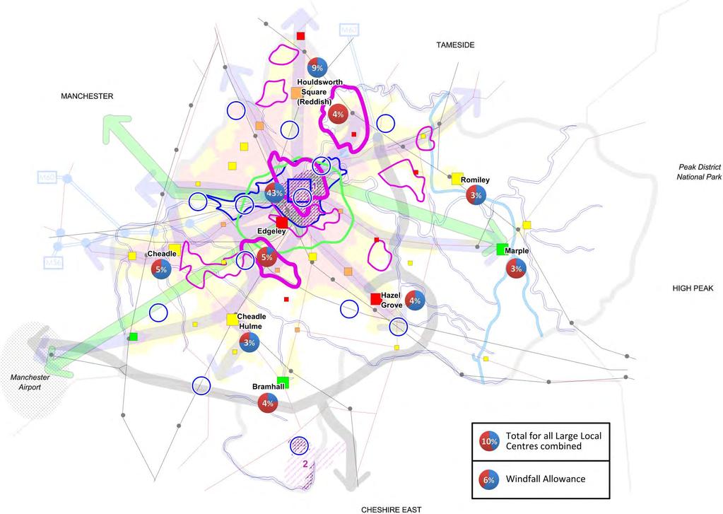
41 9

42 40 Notation used on the Key Diagram Stockport Town Centre M60 Gateway Area Very healthy centre requiring only minor enhancement Healthy centre requiring more significant enhancement Centre experiencing some difficulty requiring fairly substantial intervention Centre experiencing substantial difficulties requiring major intervention District Centres Large Local Centres Other Local Centres Employment "Centres" Neighbourhood Renewal Priority 1 Areas Neighbourhood Renewal Priority 2 Areas a. Proportion of dwellings in the area / in and around the centre likely to be flats, based on the SHLAA. b. Proportion of dwellings in the area / in and around the centre likely to be houses, based on the SHLAA. c. Percentage of the borough's total new dwellings that could be accommodated in the area / in and around the centre, based on the SHLAA and a strict interpretation of the spatial option (i.e. all new housing in the first and second spatial priorities of Core Policy CS4 'DISTRIBUTION OF HOUSING').

 Significant bus linkages (existing or to be implemented) New")
 Existing motorway (with junction) Existing other main")
43 41 Area achieving an accessibility score of >= 50 but < 60 Area achieving an accessibility score of >= 60 Central Housing Area 1 - Stockport Town Centre Strategic Area 2 - Woodford Aerodrome Opportunity Site (including existing developed area: ) Significant bus linkages (existing or to be implemented) New rail linkages (heavy or light rail) Proposed new road linkages Existing railway (with station) Existing motorway (with junction) Existing other main road Canals Rivers
44 42..2 OVERARCHING PRINCIPLES: SUSTAINABLE DEVELOPMENT - ADDRESSING CLIMATE CHANGE AND INEQUALITIES.5 This section seeks to address the following main issues: Disparities in social equity pockets of deprivation versus areas of affluence, resulting in inequalities especially in health; High levels of domestic carbon emissions, third behind Manchester and Wigan within the Greater Manchester area; and Ensure that planning policy contributes to a sustainable development approach in the Borough, particularly with regards to low carbon..6 This section will assist in delivering the following priorities of the Stockport Sustainable Community Strategy (The Stockport Strategy 2020) () : A Thriving Stockport A competitive economy with a diverse and expanding business base which attracts high earning sectors and supports high employment across sectors and skills levels. A vibrant Town Centre complemented by individual District Centres which are well used by residents and served by retail, leisure and cultural facilities. An educated population benefiting from high quality educational facilities. A Safer, Stronger Stockport Cohesive communities where people respect each other, and everyone has similar life opportunities Engaged communities who are empowered to engage and make a positive contribution to local well-being Community pride working together to ensure everyone feels safe and satisfied with their local area. A Healthy Stockport Active people with levels of obesity which maintain current rates rather than continuing to rise to the extent seen in the last decade Empowered people who are supported to make positive lifestyles choices, ultimately leading to better health outcomes for all Stockport residents Independent people who benefit from high quality and accessible facilities and services which are tailored to their needs and preferences and prevent deterioration of health and well-being People with good emotional and mental health who are confident, resilient and well-supported by family, friends and services to face life's challenges. A Greener Stockport A unique built environment which preserves our heritage and has high quality new developments A sustainable approach to the natural environment, improving air quality, minimising our use of natural resources, and maximising recycling Good connections with excellent public transport resulting in less congestion Stockport Sustainable Community Strategy (The Stockport Strategy 2020) available via
45 4 Core Policy CS1 OVERARCHING PRINCIPLES: SUSTAINABLE DEVELOPMENT - ADDRESSING INEQUALITIES AND CLIMATE CHANGE.7 In all it seeks to achieve, the Core Strategy will have regard to enabling social progress which recognises the needs of everyone, protecting the environment, ensuring the prudent use of natural resources and maintaining high and stable levels of economic growth and employment. In particular, so as to ensure that the future development of the Borough is economically, socially and environmentally sustainable, the Core Strategy will seek to address the key issues of Inequalities and Climate Change. Inequalities.8 The Council will seek to reduce levels of significant social and economic deprivation in the Borough through development policies and proposals, and complementary strategies, that provide access for all to housing, employment, education, training, health, social, other services and facilities, especially for those living within the Neighbourhood Renewal Priority Areas identified in the Neighbourhood Renewal Strategy. These policies will enable the further development of a local low carbon economy through stimulation of the market and development of the varied skills needed to deliver them..9 Use of high quality and inclusive design is an important part of shaping places in a way that can assist in addressing inequalities. Climate Change.10 The Council will seek to ensure that all development meets an appropriate recognised sustainable design and construction standard where viable to do so, in order to address both the causes and consequences of climate change. In particular, all development will be required to demonstrate how it will contribute towards reducing the Borough's carbon footprint by achieving carbon management standards..11 It is recognised that a large proportion of the borough's current CO 2 emissions are as a result of fossil fuel usage; therefore the Core Strategy will seek to identify and enable opportunities for low and/or zero carbon developments and to ensure that those opportunities are taken full advantage of. The Council considers that, because of the role it plays in reducing the Borough's carbon footprint, making and enabling the best use of renewable energy sources is a key objective for the Core Strategy. Energy opportunities identified by the Council are set out on the plan shown in C.1 'Energy Opportunities Plan'. Specific regard should also be given to the significant CO 2 emissions from transport (see..7 'TRANSPORT'). Development Management How development will be managed to deliver the Core Policy. Please note that policies relating to specific sites, areas or designations are to be set out in a separate Allocations DPD.
46 44 Development Management Policy SD-1 Creating Sustainable Communities What we're going to do or require:.12 Across the Borough as a whole development which is demonstrated to assist in the creation of Sustainable Communities will be given favourable consideration so long as it is in compliance with other development plan policies..1 Development within or linked to Neighbourhood Renewal Priority Areas will be given favourable consideration if it is demonstrated to assist in the delivery of the Neighbourhood Renewal Strategy or its supplementary action plans or masterplans..14 The Council will look favourably upon development that seeks to achieve a high rating under schemes such as the Code for Sustainable Homes, BREEAM (for non-residential development), CEEQUAL (for public-realm development), Building for Life and/or Lifetime Homes, especially where the standard attained exceeds that required by the Building Regulations. The Council will require a higher rating to be achieved at sites where assessment (through preparation of a development brief or similar) indicates that it is feasible and/or viable to do so. Why and how we're going to do it:.15 The Borough's Sustainable Community Strategy (Stockport 2020) (4) identifies the need to create more socially inclusive, sustainable communities..16 Stockport is often seen as being affluent but it has a number of neighbourhoods which experience relatively high levels of social exclusion, often caused by poor health, family breakdown, poor basic skills and a lack of affordable childcare. These problems are often repeated from one generation to the next and can lead to unemployment, limited opportunities, crime and a lack of self-esteem. The Stockport Sustainable Community Strategy sets out that the English Indices of Deprivation 2007 show the Borough to have 22 small areas within the 20% most deprived in England. Looking at the range between the ranks of the most and least deprived areas in the borough, Stockport has one of the greatest levels of disparity in social equity in the country; a statistic that demonstrates the income, employment, health, housing, education and crime inequalities that the Borough faces. The Borough's Neighbourhood Renewal Strategy identifies the key priorities for the most deprived areas and sets out a phased approach to overcoming the issues within them..17 A healthy life expectancy has not kept pace with that of life expectancy and the difference is widening for both men and women, resulting in an increasing proportion of dependent older people requiring services and care. Changes in demographic trend in both genders brings about a key shift in the way older people are living in communities. The 2001 census identified 21,46 individuals over 55 in Stockport providing at least 19 hours of unpaid care,,086 of whom provide upwards of 50 hours. 2,889 people over 65 have a significant role as a carer..18 Like the rest of England and Wales, Stockport s population is ageing markedly. Between 1991 and 2001 in Stockport the number of people aged 65 and over rose by.6%, the number aged 75 and over by 9% and the number aged 85 and over by 0.6%. 2008/09 AMR states: Stockport s 4 Stockport Sustainable Community Strategy (The Stockport Strategy 2020) available via
47 45 population according to the 2001 Census was more than 280,000 people, of which nearly a third were aged 50 or over, with nearly 4% aged between 0 and It is important that in creating more socially inclusive, sustainable communities the link between affluence and CO 2 emissions is broken. Development of a low carbon economy is key to the long term sustainability of the borough as a whole but, in particular, of the Neighbourhood Renewal Priority Areas. How we're going to measure if it's working:.20 The AMR includes a Local Indicator (LI19) which monitors the number of registrations against recognised Environmental Building and/or Design Standards (e.g. BREEAM, Code for Sustainable Homes, CEEQUAL). To some extent these standards are integrated into the building regulations (e.g. Code for Sustainable Homes) and, therefore, a target of 100% should be achieved against an increasing requirement each year. The target for the Core Strategy, therefore, is a year-on-year increase in the number of developments which seek to exceed the standard required by the building regulations up until the required standard is the maximum level possible..21 Whilst the Core Strategy and the wider LDF are not the only mechanisms for tackling the issues faced by the Borough's least affluent areas they will necessarily play a key role. A long term measure as to the collective success of these mechanisms (lead and co-ordinated by the Neighbourhood Renewal Strategy) will be the rating of the borough against key indicators such as the Indices of Multiple Deprivation and National Indicator (NI17) Healthy Life Expectancy at age 65. Development Management Policy SD-2 Making Improvements to Existing Dwellings What we're going to do or require:.22 The Council recognises the importance of improving the energy performance of Stockport s existing building stock. Therefore, installation of energy efficiency measures and low carbon and renewable technologies is encouraged..2 Planning applications for changes to existing domestic dwellings will be required, where possible and practical, to undertake reasonable improvements to the energy performance of the existing dwelling. This will be in addition to the requirements under Part L of the Building Regulations for the changes for which planning permission is sought. Improvements will include, but not be restricted to: loft and cavity wall insulation, draught-proofing, improved heating controls and replacement boilers..24 Applicants will be asked to complete a checklist (see C.2 'Energy Efficiency Checklist') to identify which measures are appropriate to their home. The total cost should be no more than 10% of the total build cost and payback in less than 7 years.the Council will support homeowners in delivering efficiency improvements by identifying financial support initiatives both regionally and nationally. Why and how we're going to do it:.25 The purpose of the policy is to reduce CO 2 emissions from existing residential buildings.
48 46.26 The policy applies to all householder applications for planning permission to extend or materially alter a home in all areas across the Borough. The approach aims to make the most of any straightforward opportunities for improvement that exist. These might include loft and cavity wall insulation, draught-proofing, improved heating controls and replacement boilers..27 The checklist approach is simple if any of the measures on the list are applicable, pay for themselves in energy cost savings in less than seven years and their combined cost does not exceed 10% of the cost of the building works, they are required. If none of the measures on the list fit the bill, none are required..28 A flexible approach will be applied when dealing with listed buildings or buildings in conservation areas. In cases where improvements cannot be made to an existing dwelling without causing harm to the significance of a heritage asset it may be suitable, as an alternative, to investigate whether specific measures could be incorporated that would help safeguard the asset from harm arising as a result of climate change (see Development Management Policy SD-6 'Adapting to the Impacts of Climate Change' and guidance provided by English Heritage (5) ). Ensuring the safeguarding of older dwellings can often be a more sustainable option than allowing their demolition and rebuilding of new dwellings to modern standards due to the CO 2 emissions that would result from the demolition/construction process. How we're going to measure if it's working:.29 Through the Comprehensive Area Assessment (CAA) process, the Council has a requirement to demonstrate overall reductions in CO 2 emissions. National Indicator (NI) 185 monitors the percentage CO 2 reduction from local authority operations and NI186 monitors per capita CO 2 emissions in the borough..0 The Council intends to maintain a database for planning applications showing the planning targets relating to CO 2 reductions that have been set and the results reported on completion. This approach will record how effective planning policy is in reducing CO 2 emissions from development..1 It is intended that the database is also used to capture information about the microgeneration systems installed, allowing Stockport to report against regional and national targets for renewable energy. Development Management Policy SD- Delivering the Energy Opportunities Plans New Development What we're going to do or require:.2 The Council recognises that different energy technologies and CO 2 reduction strategies will suit different parts of the Borough and different types of development. To reflect this two types of spatial area that have distinct energy opportunities have been identified (see C.1 'Energy Opportunities Plan'): 5 Climate Change and your Home available via
49 47 Network Development Area: Locations where the proximity of new and existing buildings creates sufficient density to support district heating and/or cooling networks (shown as "potential district heating areas" on C.1 'Energy Opportunities Plan'); and Microgeneration Area: Locations where lower densities and a fragmented mix of uses mean that only building scale solutions are possible (in effect the rest of the Borough).. New development should demonstrate how it will contribute to delivery of the opportunities identified, in-line with the following targets: Minimum target: A percentage target reduction in regulated CO 2 emissions over and above the 2006 Target Emissions Rate (TER). This is the minimum target that a development will be required to meet. The percentage target is calculated based on determining the carbon reduction of minimum cost onsite technologies that meet the current North West Regional Spatial Strategy target of 10% contribution from renewable energy plus a notional 5% uplift (i.e 15% overall). Maximum target: The maximum carbon reduction target that could be set for a development if cheaper opportunities for carbon reduction are identified by the local authority or developer. The target is given as a percentage reduction in regulated CO 2 emissions over and above the 2006 Target Emissions Rate (TER). Higher targets (beyond the minimum) will only be specified where the evidence has shown that it is cheaper to meet the minimum target through alternative means including near or offsite technologies..4 The following tables describe the targets that would apply to buildings within each spatial area type: Target 1 : Network Development Area. Development that can connect to an existing heat network or where the developer shows that it is viable and technically feasible to develop a heat network. Domestic: Commercial: Minimum (% Beyond 2006 TER) (i) 40% 0% Maximum (% Beyond 2006 TER) (A higher target may be required if the Local Authority or developer identifies a cheaper solution) (ii) 85% 45% i. ii. Minimum target derived from CO2 reduction potential from connection to gas CHP network. Where the Building Regulations target is higher, this shall be used in place of the minimum target. Maximum target derived from CO2 reduction potential at reduced cost from alternative sources. E.g. biomass CHP Target 2 : Microgeneration Area. Development that is not near to an existing heat network or cannot feasibly and viably connect to a network and therefore requires a standalone solution.
50 48 Domestic: Commercial: Minimum (% Beyond 2006 TER) (i) 40% 0% Maximum (% Beyond 2006 TER) (A higher target may be required if the Local Authority or developer identifies a cheaper solution) (ii) 100% 75% i. Minimum target derived from CO2 reduction potential from cheapest microgeneration solution. Where the Building Regulations target is higher, this shall be used in place of the minimum target. ii. Maximum target derived from CO2 reduction potential at reduced cost from alternative sources. E.g. large scale wind.5 Additionally the Council has identified several strategic opportunities for the development of renewable energy schemes and further specific "strategic opportunities" might be identified in the future (following the criteria set out in RSS policy EM17 or any subsequent superseding policy). Development may bring about opportunities to develop those schemes and, in such situations, developers will be expected to bring forward proposals linked directly to their development. Alternatively, if strategic renewable energy schemes are being progressed by the Council or a third-party, initial feasibility studies into the scheme should identify the potential for it to supply renewable energy directly to new developments; if such potential is identified then developers will be expected to make financial contributions towards delivery of the scheme as an alternative means of meeting (wholly or partially) the Minimum target that would otherwise apply. Required contributions will be equivalent to the cost meeting the minimum target, assuming the use of on-site technologies..6 To determine which target applies to a proposed development the flow-chart shown in Figure 8 'Which target should be applied to a development?' should be followed:

51 49 Figure 8 Which target should be applied to a development?.7 Where applicants can show that achieving the requirements of this policy is unviable on a particular site, they will be required to make a payment into a carbon management investment fund. This fund will provide financial resources to strategically coordinate and phase the infrastructure required to deliver larger scale energy generation technologies and infrastructure such as district heating networks, either within Stockport or within the wider City-Region. Why and how we're going to do it:.8 Changes to the Building Regulations in 2010, 201 and 2016 are expected to bring in tighter standards for CO 2 emissions. After 2016 it will be necessary for all new residential buildings to be delivered as zero carbon homes, with the equivalent standard for non-residential buildings due to be introduced in It is suggested that the role of planning in requiring new development to incorporate low carbon and renewable technologies should therefore be limited to a supporting one..9 This policy seeks to accelerate the move towards zero carbon ahead of Building Regulations. All new buildings, both residential and non-residential, will be expected to achieve a percentage reduction over the 2006 Target Emissions Rate (TER). The targets have been developed based on the carbon reductions achievable from the least cost on-site technology to achieve the 10% North West Regional Spatial Strategy target for renewable energy in new development plus 5% (i.e 15% overall)..40 The policy recognises that different character areas and development types will have different opportunities for achieving CO 2 reductions. For example, developments in microgeneration areas will have different opportunities for delivering CO 2 reductions than those in a heat network development area.
52 50.41 Where strategic renewable energy opportunities are identified that might be brought about by development they will be detailed as far as possible in the separate Allocations DPD..42 Where applicants can show that achieving the requirements of the policy is unviable on a particular site they will be required to contribute to a reduction in the Borough's carbon footprint by making a payment into a carbon management investment fund established by Stockport Council or at a City-Region level. The amount to be paid will be calculated based upon the cost of CO 2 at the time the application is decided and the amount of CO 2 emitted per square metre of floor area over a 0 year period..4 Testing of this policy relative to Stockport s situation has been undertaken and is detailed in the Stockport Climate Change and Energy Study (6)..44 Developers should demonstrate compliance by submitting a carbon reduction statement setting out how the target designation was arrived at including any feasibility studies (e.g. to assess the feasibility of a heat network).the statement should set out how the developer will meet the appropriate target for the development..45 In developing schemes to take advantage of the energy opportunities, specific and careful consideration should be given to minimising any negative impacts upon sensitive landscape areas, including the neighbouring Peak District National Park, and upon the Green Belt. How we're going to measure if it's working:.46 Through the Comprehensive Area Assessment (CAA) process, the Council has a requirement to demonstrate overall reductions in CO 2 emissions. National Indicator (NI) 185 monitors the percentage CO 2 reduction from local authority operations and NI186 monitors per capita CO 2 emissions in the borough..47 The Council intends to maintain a database for planning applications showing the planning targets relating to CO 2 reductions that have been set and the results reported on completion. This approach will record how effective planning policy is in reducing CO 2 emissions from development..48 It is intended that the database is also used to capture information about the microgeneration systems installed, allowing Stockport to report against regional and national targets for renewable energy. Development Management Policy SD-4 District Heating (Network Development Areas) What we're going to do or require:.49 The Council is keen to take advantage of opportunities to install district heating across the Borough. New development in Network Development Areas, where technically feasible and financially viable, should contribute to this objective by considering district heating for meeting the requirements of Core Policy CS1 'OVERARCHING PRINCIPLES: SUSTAINABLE DEVELOPMENT - ADDRESSING INEQUALITIES AND CLIMATE CHANGE'. The Council recognises that different development types will have different opportunities, therefore: 6 Stockport Climate Change and Energy Study available via
53 51 1. All developments should seek to make use of available heat, biomass and waste heat. 2. Small developments (less than 100 dwellings or non-residential developments less than 10,000m 2 ) should connect to any available district heating networks. Where a district heating network does not yet exist, applicants should install heating and cooling equipment that is capable of connection at a later date and which could serve (or could be easily adapted to serve) that wider network if and when required.. Large and mixed-use developments (over 100 dwellings or non-residential developments over 10,000m 2 ) should install a district heating network to serve the site.the council's ambition is to develop strategic area wide networks and so the design and layout of site-wide networks should be such as to enable future expansion into surrounding communities. Where appropriate, applicants may be required to provide land, buildings and/or equipment for an energy centre to serve existing or new development. 4. New development should be designed to maximise the opportunities to accommodate a district heating solution, considering: density, mix of use, layout and phasing. 5. Where investment or development is being undertaken into or adjacent to a public building, full consideration should be given to the potential role that the public building can have in providing an anchor load within a decentralised energy network. Why and how we're going to do it:.50 The PPS1 Supplement actively encourages opportunities to be sought to set higher standards on specific sites where it can be justified on viability and feasibility grounds. The purpose of this policy is to prioritise district heating in areas where opportunities are the greatest and to take advantage of the availability of waste heat in some parts of the Borough..51 The long-term ambition is to deliver a strategic district heating network across the Borough. The council recognises that the opportunities for installing such a network across existing communities is, for the most part, beyond the scope of planning. Therefore, the policy requires development to be able to connect once such a network is in place and to be designed to be compatible with future networks, in terms of layout density and so on. The policy requires larger more strategic new developments to install their own network, which can later be connected up to a larger network. This has the benefit of reducing CO 2 emissions in new development and/or contributing to the longer term objective..52 Where appropriate, applicants may be required to provide land, buildings and/or equipment for an energy centre to serve proposed or multiple developments. Such a requirement will be important for ensuring availability of the necessary space in the right location for an energy centre designed to serve more than one development. It is expected that requirements will be discussed in pre-application discussions and will be included as part of a planning condition..5 Criteria that have been used to define the Network Development Areas are set out below. New development: Residential development of at least 55 dwellings per hectare and at least 100 dwellings Large scale mixed use development enables good anchor load
54 52 Proximity to high heat density areas of existing buildings enables extension into existing development Proximity to existing heat sources Existing development: Heat demand density of at least,000kw/km 2 and residential density of at least 55 dwellings per hectare or presence of a public sector building to provide a good anchor load Proximity to sources of heat (e.g. industrial processes) enables zero carbon energy source How we're going to measure if it's working:.54 Through the Comprehensive Area Assessment (CAA) process, the Council has a requirement to demonstrate overall reductions in CO 2 emissions. National Indicator (NI) 185 monitors the percentage CO 2 reduction from local authority operations and NI186 monitors per capita CO 2 emissions in the Borough..55 The Council intends to maintain a database for planning applications showing the planning targets relating to CO 2 reductions that have been set and the results reported on completion. This approach will record how effective planning policy is in reducing CO 2 emissions from development..56 It is intended that the database is also used to capture information about the microgeneration systems installed, allowing Stockport to report against regional and national targets for renewable energy. Development Management Policy SD-5 Community Owned Energy What we're going to do or require:.57 The Council recognises the important role that community owned energy generation including wind and hydro energy will play in reducing CO 2 emissions and increasing installed low carbon and renewable energy capacity. While the Council will consider favourably all applications for standalone or onsite low carbon and renewable energy generation, the Energy Opportunities Plan identifies a number of principal opportunities: Large wind turbines or hydro energy schemes delivered by community groups and/or commercial developers. New development that is designated as being in a microgeneration area and either a community wind priority area, or adjacent to a potential hydro energy scheme should consider wind/hydro energy as their first option for meeting the requirements of Development Management Policy SD- 'Delivering the Energy Opportunities Plans New Development'. Wind Priority Areas have been designated to encourage applications for large and small turbines, particularly but not exclusively: from community groups, co-operatives and individuals related to new domestic and non-domestic developments. Large and mixed-use developments in appropriate locations should consider installing a wind turbine or turbines to serve the site s energy needs.
55 5 Why and how we're going to do it:.58 The primary driver for such a strongly worded supportive policy is to promote the adoption of community owned energy generation in addition to delivery by commercial developers. The PPS1 Supplement on Planning and Climate Change and PPS22 (Renewable Energy) are both supportive of wind power and hydro power and this policy has been worded accordingly. Wind and hydro energy in Stockport will be vital if the twin challenges of achieving the national and legally binding 4% reduction in CO 2 emissions over 1990 levels by 2020 and the equally binding requirement for the UK to generate 15% of its total energy from renewable sources, also by 2020 is to be met.the government's Renewable Energy Strategy expects a significant proportion of this to be delivered from onshore wind. It is evident therefore that every available and suitable opportunity for wind and hydro energy needs to be taken advantage of. 'SWMP will also assist with Stockport's Sustainable Communities and Green Infrastructure objectives'.59 Despite there being good wind speeds across all parts of the Borough it is recognised that commercial opportunities for turbines are likely to be limited. The Stockport Climate Change and Energy Study (7) identifies what these constraints are. However, opportunities for individual large turbines or smaller turbines exist across the borough and the council is keen to take advantage of these and has identified potential Wind Priority Areas based on the following criteria: Good local wind resource, consider hilltops, avoid forested areas. Close to electricity infrastructure (e.g. 10-0kV power lines, substations) to connect to grid. Close to roads, railways for easier transport of components to site. Close to the community involved (but not close enough to cause noise or telecoms interference issues). Consideration of environmentally and archaeologically sensitive areas. Consideration of areas of high landscape quality (e.g. due to proximity to the Peak District National Park). Consideration of aviation infrastructure and defence structures (e.g. radars and flight paths). Consideration of local residential areas/properties..60 Clearly some of these criteria are the same as those used by commercial wind developers. An important distinction could be the proximity to the community involved. Here it has been assumed that communities investing in their own wind turbine would be keen to be able to see it (although some may not), but equally these locations are less likely to be of interest to commercial developers..61 Developments within wind priority areas or adjacent to potential hydro power schemes will need to show in a design and access statement that they have fully considered the potential to deliver a reduction in the development s CO 2 emissions beyond Building Regulations using wind turbine(s) or hydro power. Where no opportunities exist, on-site applicants should demonstrate that they have considered off-site opportunities. How we're going to measure if it's working:.62 Through the Comprehensive Area Assessment (CAA) process, the Council has a requirement to demonstrate overall reductions in CO 2 emissions. National Indicator (NI) 185 monitors the percentage CO 2 reduction from local authority operations and NI186 monitors per capita CO 2 emissions in the borough. 7 Stockport Climate Change and Energy Study available via
56 54.6 The Council intends to maintain a database for planning applications showing the planning targets relating to CO 2 reductions that have been set and the results reported on completion. This approach will record how effective planning policy is in reducing CO 2 emissions from development..64 It is intended that the database is also used to capture information about the microgeneration systems installed, allowing Stockport to report against regional and national targets for renewable energy. Development Management Policy SD-6 Adapting to the Impacts of Climate Change What we're going to do or require:.65 Development should be designed in such a way as to avoid, mitigate or reduce the impacts of climate change..66 In particular, all development will be required to incorporate Sustainable Drainage Systems (SuDS) so as to manage the run-off of water from the site. Development on previously developed (brownfield) land must reduce the rate of unattenuated run-off by a minimum of 50% if it is within an identified Critical Drainage Area (CDA). Until CDAs have been identified in detail the same reduction (a minimum of 50%) will be required of developments on brownfield sites in all areas; once detailed CDAs have been identified the minimum required reduction of run-off on brownfield sites outside of CDAs will be 0%. Development on greenfield (not previously developed) sites will be required, as a minimum, to ensure that the rate of run-off is not increased..67 Where planning permission is required, areas of hard-standing or other surfaces, should be of a permeable construction or drain to an alternative form of SuDS..68 Development, particularly within the urban area of the Borough, that takes into account the urban heat island effect and incorporates measures to reduce this phenomenon will be given positive consideration. Measures might include: Provision of appropriate greencover (shaded green space and tree cover); Provision of green roofs, walls and boundaries; Urban design that encourages air flow throughout the development; Passive cooling that allows natural ventilation to cool the building or development in preference to mechanical cooling (8) ; Solar shading designed into buildings to avoid internal overheating; or Water features such as lakes, ponds, fountains and watercourses..69 Measures such as SuDS and those required to reduce the impact of the urban heat island effect are key considerations in achieving a high rating within recognised sustainable development rating systems such as the Code for Sustainable Homes, BREEAM (for non-residential developments) or CEEQUAL (for public realm development). The Council will look favourably upon development that seeks to achieve a standard that exceeds the Building Regulations and will provide guidance and advice to developers seeking to do this. The Council will require a 8 Passive cooling is preferential to mechanical cooling because mechanical cooling generates waste heat which only serves to worsen the height island effect outside of the building being cooled
57 55 higher rating to be achieved at sites where assessment (through preparation of a development brief or similar) indicates that it is feasible and/or viable to do so..70 In all cases where development of listed buildings, development within conservation areas or development involving other heritage assets is proposed, specific regard should be given to the inclusion of measures to ensure their long-term safeguarding against the impacts of climate change. Why and how we're going to do it:.71 The Strategic Flood Risk Assessment (SFRA) undertaken for Greater Manchester and, at a more detailed level, Stockport Town Centre (9) recommends that all development on previously-developed land should include measures that will reduce the rate of run-off of water to the extent required by the policy. It follows, also, that development on non-previously developed land should not increase the rate of run-off of water. The SFRA identifies Critical Drainage Areas (CDAs) but, due to the uncertainty of Areas Susceptible To Surface Water Flooding (ASTSWF) data and lack of sufficient historical flooding data and sewer model data, it is recommended (and agreed with the Environment Agency) that a precautionary approach be taken until such a time as more accurate data allows more accurate definition of CDAs (either through a future update of the SFRA or through preparation of a Surface Water Management Plan (SWMP) covering the borough. A SWMP would also assist with achieving objectives relating to addressing inequalities and the provision of Green Infrastructure (see..6 'SAFEGUARDING AND IMPROVING THE ENVIRONMENT'))..72 Since October 2008 planning permission has been required for the laying of new or replacement hard surfaces (above 5m square) at the front of dwellings where they are of impermeable (non-porous) construction. The reason for this is to reduce problems caused by heavy rainfall running off private properties and inundating highway and other drainage systems. This problem is expected to be worsened by increasing incidents of extreme weather as a result of climate change. The use of impermeable surfacing, therefore, will not be permitted unless it is designed in such a way as to drain into an alternative form of SuDS..7 The urban heat island effect is responsible for temperature differences of up to 7ºC between urban and rural areas in the UK (40). This problem will become heightened under future climate change scenarios published by the Government (41) ; based on a low emissions scenario these show a likelihood that temperatures in the part of North West of England around Stockport will increase by between 2 and 4 degrees between the present day and the 2080's, with increases of up to 6 degrees under higher emissions scenarios. This means that the cooling of the urban environment is necessarily a priority so as to ensure future human comfort and well-being. Further information is available in the Council's adopted Sustainable Design and Construction SPD (42) and also from the UK Climate Impacts Programme (UKCIPS) (4).74 The Stockport Climate Change and Energy Study concludes that, for reason of technical feasibility and/or financial viability it would not be reasonable to place a general requirement on all developments to meet a specific level within assessment schemes such as the Code for Sustainable Homes or BREEAM beyond that which is (or will be) required by the Building Regulations. However, 9 Strategic Flood Risk Assessment (SFRA) available via 40 Smith, C & Levermore, G (2008) "Designing urban spaces and buildings to improve sustainability and quality of life in a warmer world" available via 41 UK Climate Projections available via 42 Sustainable Design and Construction SPD available via 4 UK Climate Impacts Programme (UKCIPS) available via
58 56 there are significant benefits to be achieved through improving the overall environmental performance of new developments and therefore developers will be encouraged to, and assisted in, attaining a higher standard and will be required to meet a higher standard in situations where further evidence demonstrates that it is feasible/viable..75 The inclusion of water features within developments, particularly those on, adjacent to or linked to existing watercourses, is a key component of implementing the North West River Basin Management Plan (RBMP) (44) which is the Statutory Instrument for implementing the Water Framework Directive. Regard will be had to the RBMP in determining planning applications and developers of appropriate schemes will be expected to work with the Council and the Environment Agency to achieve its objectives..76 Some of the Borough's historic assets have already experienced and survived significant climatic changes in the past and may demonstrate considerable resilience in the face of future climate change. However, many historic assets are potentially at risk from the direct impacts of future climate change. Without action to adapt to a changing climate and limit further changes it is likely that these will be irreparably damaged and the cultural, social and economic benefits they provide will also be lost. Equally, the significance and integrity of important historic assets can be threatened by poorly designed adaptation and mitigation responses. The non-renewable character of historic features and the potential for their damage and loss should, therefore, always be taken into account when adaptation and mitigation responses are being planned and executed. Guidance on the adaption of heritage assets to ensure their safeguarding against the impacts of climate change is available from English Heritage (45). How we're going to measure if it's working:.77 A target of 100% of new developments or redevelopment schemes, where it is technically feasible, incorporating SuDS type systems to the required standard will be set and reported on in the Annual Monitoring Report (AMR)..78 The AMR includes a local indicator (LI19) which monitors the number of registrations against recognised Environmental Building and/or Design Standards (e.g. BREEAM, Code for Sustainable Homes, CEEQUAL). To some extent these standards are integrated into the building regulations (e.g. Code for Sustainable Homes) and, therefore, a target of 100% should be achieved against an increasing requirement each year. The target for the Core Strategy, therefore, is a year-on-year increase in the number of developments which seek to exceed the standard required by the building regulations up until the required standard is the maximum level possible. Key Infrastructure Requirements Key infrastructure required to deliver the core policy What Infrastructure required to deliver the Neighbourhood Renewal Strategy, identified in area specific Who & How The Council with public and private sector partners and developers through implementation of the Neighbourhood Renewal Strategy and its associated masterplans and strategies. When To be defined by the Neighbourhood Renewal Strategy and its associated area specific masterplans and strategies. 44 North West River Basin Management Plan (RBMP) available via 45 English Heritage available via
59 57 What masterplans and strategies. District heat networks. Renewable energy infrastructure. Infrastructure required to enable adaptation to the impacts of climate change. Who & How The Council and private developers through (re)development proposals. Private and/or community developers. The Council will play an advisory/co-ordination role. Private developers through (re)development proposals. The Council with public and private sector partners through (re)development schemes, particularly in relation to the public realm. When Whenever appropriate (re)development proposals are brought forward. Whenever appropriate (re)development proposals are brought forward. Whenever appropriate (re)development proposals are brought forward.
60 58.. PROVIDING A DECENT HOME FOR EVERYONE.79 Providing new housing is a key national policy objective, to ensure that everyone has the opportunity of living in a decent home, which they can afford, in a community where they want to live. More new homes are needed to keep up with rising demand brought about by a growing population and falling average household size. Providing good quality housing in suitable locations close to community facilities, jobs and transport links can improve affordability, create better communities and attract investment and skilled workers..80 The Regional Spatial Strategy (RSS) sets out the overall level of new housing provision for the North West and how it should be distributed across the region. Stockport is required to provide an average of 450 additional new homes a year. At least 80% of which should be on previously-developed land. New housing provision in Stockport should support regeneration and meet local needs, in sustainable locations which are well served by public transport..81 Affordable housing is a critical issue to address. National planning policy seeks to widen opportunities for home ownership, ensure high quality housing for those who cannot afford market housing, and improve affordability, including by increasing the supply of housing. Regional planning policy acknowledges the greatest need will be in areas of high demand, due to high prices and low wages, and states that residential development in this part of the region will be focused on meeting local needs, particularly affordable housing. The average house price in Stockport is the second highest in Greater Manchester and the ratio of lower quartile house prices to lower quartile incomes in 2008 was 7:1 (46). In 2010 there were 7,626 households on the waiting list for social housing and the estimated annual affordable housing shortfall is 519 dwellings (47). There is therefore a significant local need for affordable housing in Stockport..82 This section will assist in delivering the following priorities of the Stockport Sustainable Community Strategy (The Stockport Strategy 2020) (48) : A Thriving Stockport A vibrant Town Centre that is well used by residents Transform the Town Centre and M60 corridor by making it a priority for development A Safer, Stronger Stockport Support a diverse population and create cohesive communities A Healthy Stockport Maximise opportunities for adults with a disability and support independent living Remove barriers which prevent older people living independent lives Address health inequalities between affluent and priority neighbourhoods A Greener Stockport Strike an appropriate balance between development and protection 46 Regional Spatial Strategy Annual Monitoring Report 2010 (Chapter Data Tables) available via 47 Housing Needs Study 2008 (section 1.5, page 100) available via 48 Stockport Sustainable Community Strategy (The Stockport Strategy 2020) available via
61 59 Have a sustainable approach to the natural environment - minimise the use of natural resources Invest in affordable housing, particularly social rented housing, to meet demand for a greater mix of housing across the borough, and maximise opportunities offered by Council owned land Core Policy CS2 HOUSING PROVISION.8 A wide choice of high quality homes will be provided to meet the requirements of existing and future Stockport households. The focus will be on providing new housing through the effective and efficient use of land within accessible urban areas, and making the best use of existing housing..84 Provision will be made for a net additional 7,200 homes over the 15 year period from 2011 to Land for new housing will be released in an orderly and managed way based on the averages in the following trajectory: 450 new homes per annum between 2011 and new homes per annum between 201 and new homes per annum between 202 and The level of provision between 201 and 202 equates to a 10% increase on Stockport's current annual requirement, for a 10 year period. Increasing the supply of housing will improve affordability, help meet the need for affordable housing and support the delivery of additional housing growth in Greater Manchester. The 10% increase will not apply if Stockport's housing requirement is increased at the regional planning level..86 Provision will be made for Gypsy and Traveller pitches and Travelling Showpeople plots, equal to the requirements identified in the latest Gypsy and Traveller Accommodation Assessment, subject to any agreed dedistribution of requirements amongst local authorities within the Greater Manchester sub-region..87 The local previously-developed land target is at least 90%. This applies from 2011 onwards when there is a five year deliverable supply. It does not apply to sites providing 50% affordable housing or more. The regional target of at least 80% of housing provision on previously-developed land applies to sites providing 50% affordable housing or more.this secondary target also applies to all sites when there is less than a five year deliverable supply, from 2011 onwards. Existing housing.88 The existing housing in 2011 will make up 95% of the housing stock in It is therefore important to safeguard and make best use of the existing stock. This will be done by improving the condition of housing (including achieving the Decent Homes standard), reducing vacancy rates, avoiding the unnecessary loss of housing, safeguarding the residential amenity of housing, and protecting the character and quality of predominantly residential areas..89 The current Strategic Housing Land Availability Assessment (49) (SHLAA) includes a potential housing supply of 9,195 dwellings from the base date of April 2008 (see Table 1 'Number of additional 49 Strategic Housing Land Availability Assessment 2010 available via
62 60 dwellings (net) in the SHLAA (April 2008 base date)'). At least 95% of the dwellings in the first 5 years of the SHLAA are on previously-developed land (PDL). The vast majority of these dwellings have planning permission and they are the most 'deliverable' (50) in the supply. The PDL trajectory for this period is therefore 95%..90 There are over,400 dwellings on PDL in years 6 to 10. This is well over a 5 year supply and is enough to provide 100% of new housing on PDL. However, the Core Strategy allows some Greenfield development, particularly where affordable housing is being provided. Therefore, the PDL trajectory is 95% to take account of this flexibility..91 There are approximately 1,950 dwellings on PDL in years 11 to 15. This is not enough for a 5 year supply. The PDL trajectory has therefore been lowered to 85%. The percentage would be less but for expected excess completions in earlier years. Table 1 Number of additional dwellings (net) in the SHLAA (April 2008 base date) Time Period Number of Specific Sites Number of Dwellings Number of Houses Number of Flats % on PDL (i) PDL Trajectory 0 to 5 years % 95% 6 to 10 years % 95% 11 to 15 years (ii) % 85% Total % Supply (iii) 19.2 years 17.0 years 21. years i. Column contains estimated revisions to the PDL figures in the SHLAA following reclassification of gardens as Greenfield land in re-issued PPS (June 2010) ii. Includes a windfall allowance of 450 dwellings made up of 180 houses and 270 flats iii. At an annual average target of 480 dwellings (7,200 divided by 15) - made up of 240 houses and 240 flats.92 Taking into account actual and projected completions from 2008, there are likely to be 8,295 dwellings in the supply as at April 2011 (51). This is enough housing to achieve the trajectory in Core Policy CS2 'HOUSING PROVISION'. The SHLAA includes 450 dwellings at Woodford Aerodrome Opportunity Site (see..9 'Woodford Aerodrome Opportunity Site') and 759 dwellings on 20 Green Belt sites that do not have planning permission and are not Major Existing Developed Sites. The Green Belt sites consist of 8 Greenfield sites (587 dwellings) and 12 PDL sites (172 dwellings)..9 Stockport's RSS housing requirement is 6,750 dwellings between 2011 and 2026 (although the strategy seeks a 10% increase between 201 and 202). Without the 20 Green Belt sites referred to above the estimated housing supply in 2011 is 7,56 dwellings. Given that this is only 12% above the RSS requirement it may be necessary to release Green Belt land for housing if other sites in the SHLAA are not developed at the point envisaged..94 According to the latest assessment carried out in 2010 there is less than a five year deliverable supply of land for housing in Stockport. In order to top up the supply, planning applications for housing 50 See Planning Policy Statement : Housing paragraph See SHLAA report paragraph 5.10
63 61 will be considered more favourably through the measures set out in Development Management Policy H-2 'Housing Phasing' (paragraph.117). Core Policy CS MIX OF HOUSING.95 A mix of housing, in terms of tenure, price, type and size will be provided to meet the requirements of new forming households, first time buyers, families with children, disabled people and older people. New development should contribute to the creation of more mixed, balanced communities by providing affordable housing in areas with high property prices and by increasing owner occupation in areas of predominantly social rented housing..96 The overall strategic affordable housing target is 50% of total provision. The Council will aim to achieve this challenging target with the assistance of Stockport Homes and developments by other affordable housing providers delivering up to 100% affordable housing; by maximising opportunities offered by Council owned land, by releasing additional land for housing, and through developer contributions. The target will remain in place until it can no longer be justified by housing need and a shortage of affordable housing..97 Support will be given to the provision of specialist and supported housing for older people and people with a disability. All new housing should enable older people and adults with a disability to live independent lives by seeking to achieve Lifetime Homes standards..98 The supply of land for housing should be flexible enough to provide a balanced mix of houses and flats, so that the type of housing likely to be required in the borough can be provided. Over the plan period the aim is to achieve a 50:50 split between the provision of new houses and new flats. This is supported by the findings of the Strategic Housing Market Assessment (52)..99 The mix of housing provided should be based upon the findings of up-to-date evidence. The current Housing Needs Study (5) suggests: large family market houses and smaller low-cost market houses should both be provided; intermediate houses should have two-three bedrooms; social rented houses should have three-four bedrooms; and the majority of new flats of all tenures should have two bedrooms..100 On sites that are capable of accommodating a range of housing types and sizes, developments should contribute to the provision of an appropriate borough-wide mix of housing, reflecting the different types and sizes of housing likely to be required over the plan period..101 Sites in the most central locations, such as the Town Centre areas and within District and Local Centres, are the most suitable for flats. Here housing densities of 70 dwellings per hectare (dph) and above are commonplace. Moving away from these central locations densities should gradually decrease, first to around 50 dph then to around 40 dph, as the proportion of houses increases. Developments in accessible suburban locations may be expected to provide 52 Greater Manchester Strategic Housing Market Assessment 2008 (section 5.5., pages 22-2) available via 5 Housing Needs Study section 14.1 page 106
64 62 the full range of houses, from low-cost 2 bed terraces to executive 5+ bed detached, and contain few flats. However, they should still achieve a density of 0 dph..102 The presumption is that existing family houses will be retained in suburban areas, not replaced by new build flats or conversions to flats. Core Policy CS4 DISTRIBUTION OF HOUSING.10 New housing development will boost the Town Centre economy, making it a vibrant place to be during the day and in the evening. It will improve the built environment by regenerating vacant and under-used sites in and around the centre, and provide homes in a location readily accessible to jobs and services within Stockport and Manchester City Centre. New housing will also assist the vitality and viability of District and Local Centres, and support regeneration and improve housing choice in Neighbourhood Renewal Priority Areas..104 The distribution of housing across the borough should be broadly in line with the following spatial priorities: firstly, the Central Housing Area containing up to 50% of provision, including up to 2,000 dwellings in the Town Centre areas (54) ; secondly, Neighbourhood Renewal Priority Areas and the pedestrian catchment areas (55) of District and Large Local Centres, containing at least 5% of provision; thirdly, other accessible locations, containing up to 15% of provision..105 New housing development will be assessed in terms of its accessibility to jobs, community facilities, shops and services. All housing development in the first ten years of the plan period will be in locations that are amongst the most accessible in the borough. Additional land will be released within the third spatial priority if necessary to provide the required level and right mix of housing. It should be noted that new development could include measures that are demonstrated to improve accessibility to an appropriate degree and could then be considered acceptable. Urban Greenfield and Green Belt sites.106 Urban Greenfield and Green Belt sites will be allocated for housing in the Allocations DPD if this is necessary to meet the borough's local needs, particularly the need for affordable housing, and to provide an appropriate mix of housing, including improving housing choice and diversifying tenure in Neighbourhood Renewal Priority Areas. Such sites will not be allocated solely to achieve the housing trajectory's increased level of provision between 201 and 202, and any change to the Green Belt boundary must be justified by exceptional circumstances. This section of the policy does not apply to Major Existing Developed Sites, or buildings in the Green Belt to be re-used for housing..107 The focus is on making effective use of land within accessible urban areas. The priority for development is therefore previously developed land within urban areas. Urban Greenfield and Green Belt development should accord with the following sequential approach: 54 Currently the TCG2 and TCG areas shown on the UDP Review Proposals Map 55 Commonly defined as the areas within a 10 minute walk (up to 800m) of a centre
65 6 firstly, the use of accessible urban sites that are not designated as open space, or considered to be areas of open space with amenity value; secondly, the use of private residential gardens in accessible urban locations where proposals respond to the character of the local area and maintain good standards of amenity and privacy for the occupants of existing housing, in accordance with Development Management Policy H-1 'Design of Residential Development'; thirdly, the use of accessible urban open space where it can be demonstrated that there is adequate provision of open space in the local area or the loss would be adequately replaced, in accordance with Core Policy CS8 'SAFEGUARDING AND IMPROVING THE ENVIRONMENT'; fourthly, and only if it is essential to release additional land to accommodate the borough's local needs, particularly the need for affordable housing or to support regeneration strategies in Neighbourhood Renewal Priority Areas, a limited number of the most suitable Green Belt sites will be used for housing. Sites must be accessible, attached to the urban area, maintain openness between built-up areas, and there must be no exceptional substantial strategic change to the Green Belt or its boundaries..108 Only local adjustments will be made to the Green Belt and sites will only be released if they make a significant contribution to meeting local needs, particularly the need for affordable housing. Small infill sites within the Green Belt, for example within residential ribbon development, will not be used for housing due to the negligible contribution they would make to meeting local needs and the harmful cumulative impact such development would have on the openness of the Green Belt..109 When considering Green Belt release, regard will be had to, amongst other things: maintaining openness; the purposes of including land in Green Belts (including preventing neighbouring towns from merging into one another); the Green Belt land use objectives; and the need to provide clearly defensible boundaries. Gypsy, Traveller and Travelling Showpeople sites.110 The criteria below will be used to guide the allocation of sites for Gypsies, Travellers and Travelling Showpeople. These criteria will also be used to meet unexpected demand. Sites should be regarded as suitable for housing development, and: 1. reasonably accessible to local services such as shops, health care and schools; 2. reasonably accessible to employment opportunities; and. sites for Travelling Showpeople should be suitable for mixed residential and business uses, and have safe and convenient access to the Motorway or Strategic Road Network..111 Sites that meet the above criteria and are within the urban area are preferable and will be considered before Green Belt sites. If sufficient sites cannot be found within the urban area then Green Belt sites that meet the criteria and are well-located to the urban area will be considered. Development Management How development will be managed to deliver the Core Policies. Please note that policies relating to specific sites, areas or designations are to be set out in a separate Allocations DPD.
66 64 Development Management Policy H-1 Design of Residential Development What we're going to do or require:..112 The design and build standards of new residential development should be high quality, inclusive, sustainable and contribute to the creation of successful communities. Proposals should respond to the townscape and landscape character of the local area, reinforcing or creating local identity and distinctiveness in terms of layout, scale and appearance, and should consider the need to deliver low carbon housing. Good standards of amenity, privacy, safety / security and open space should be provided for the occupants of new housing and good standards of amenity and privacy should be maintained for the occupants of existing housing. (For further guidance see the Design of Residential Development and Sustainable Design & Construction SPDs.).11 New Gypsy, Traveller and Travelling Showpeople sites should respect the scale of, and not dominate the nearest settled community. Why and how we're going to do it:.114 To ensure Core Policy CS2 'HOUSING PROVISION' is delivered and new housing is well-designed and built to a high standard, and to safeguard and make best use of the existing stock. The policy will help to create and maintain attractive neighbourhoods and encourage environmentally friendly residential developments. How we're going to measure if it's working: Undertake Building for Life Assessments. Monitoring the number of registrations against recognised Environmental Building and / or Design Standards (E.g. Code for Sustainable Homes). Development Management Policy H-2 Housing Phasing What we're going to do or require:.115 The delivery and supply of housing will be monitored and managed to ensure provision is in line with the housing trajectory, the local previously-developed land target is being achieved and a continuous five year deliverable supply of land for housing is maintained..116 During the first ten years of the plan period ( ), when there is a five year deliverable supply: the local previously-developed land target will apply; planning applications providing additional housing should be on sites within the first and second spatial priorities listed in Core Policy CS4 'DISTRIBUTION OF HOUSING', or on sites achieving a score of at least 50 when assessed against the Council's accessibility model (see..1 'Key Diagram' and the Accessibility Appraisal of the Core Strategy);
67 65 in addition, planning applications that are wholly or predominantly for flats should be on sites within the first and second spatial priorities and achieve a score of at least 60 when assessed against the accessibility model. Exceptions may be made for Local Centre and edge of centre sites, flats above shops, mill conversions, and other sites with particular constraints that influence housing type; housing developments in other accessible locations will be permitted if they achieve one or more of the following regeneration benefits: re-use of vacant previously-developed land and / or vacant (typically non-residential) buildings; re-use of a Listed or Locally Listed Building; provision of at least 50% affordable housing; provision of specialist and supported housing for older people and people with a disability; facilitating the operation of an existing or new community facility (used or to be used for education, leisure or social purposes)..117 When there is less than a five year deliverable supply during the first ten years of the plan period, Stockport's regional previously-developed land target of 80% will apply to all developments. The required accessibility score for sites outside the first and second spatial priorities will also be gradually lowered on an annual basis, for example from 50 to 45. The required accessibility score for developments consisting wholly or predominantly for flats will be gradually lowered in the same way, but they should still be within the first and second spatial priorities. These measures will allow the deliverable supply to be topped up by sites in other accessible locations. If sites do not achieve the lowered accessibility score they may still be permitted if they achieve one of the regeneration benefits listed above..118 After the first ten years of the plan period the local previously-developed land target will still apply when there is a five year deliverable supply. However, the required accessibility score for sites outside the first and second spatial priorities will be lowered if necessary to maintain the five year deliverable supply. Why and how we're going to do it:.119 To ensure Core Policy CS2 'HOUSING PROVISION'is delivered and sufficient housing is provided in accessible locations, in a way that makes effective use of land, supports regeneration and does not undermine neighbouring housing markets..120 To ensure Core Policy CS 'MIX OF HOUSING'is delivered, to help address the affordable housing shortfall, to enable all adults to live independently, and to provide flats in the most accessible, appropriate locations, where there is an adequate supply to meet the borough's requirements..121 To ensure Core Policy CS4 'DISTRIBUTION OF HOUSING' is delivered and all housing development is genuinely accessible by public transport, walking and cycling to jobs, community facilities, shops and services. In line with the Regional Spatial Strategy, development is partly focused in and around the centre of town. The Sustainable Community Strategy seeks a vibrant Town Centre that is well used by residents, and it makes it a priority for development. The evidence (56) also suggests encouraging urban living in the Town Centre. The approach will greatly assist Town Centre shops and services, help develop the centre's evening economy, and improve housing choice by providing 56 Strategic Housing Market Assessment section 7.9 page 295
68 66 low-cost market and intermediate affordable housing for new forming households and existing households (including first time buyers) in the borough's most accessible location. It will also support shops and services in the borough's established centres and contribute to the social, economic and physical regeneration of the more deprived areas..122 All of the sites in the SHLAA have been assessed using the Council's accessibility model. The model focuses on the journey origin (the home end of the journey) and uses land use data to look at the level of accessibility by walking and public transport to the following types of location: Employment Retail Food retail Evening economy uses Primary and Secondary Schools Health Centres and General Hospitals.12 Each site in the SHLAA has been given an accessibility score and then ranked in order and grouped into deciles (57) (see Table 2 'Accessibility of dwellings on specific sites in the SHLAA (April 2008 base date) Figures exclude the windfall allowance of 450 dwellings'). The deciles relate to areas of the borough of equal size and the higher the score the more accessible the sites are. Table 2 Accessibility of dwellings on specific sites in the SHLAA (April 2008 base date) Figures exclude the windfall allowance of 450 dwellings Decile Lower threshold score Supply Cumulative Supply Supply of Houses Cumulative Supply of Houses Supply of Flats Cumulative Supply of Flats Average density (dph) Taking into account actual and projected completions from the SHLAA base date, there are approximately 5,500 dwellings from the supply of specific sites to be provided by As can be seen in the table, this can be provided on sites scoring 55 or above. However, amongst these sites will be some that are unlikely to be developed by In contrast there will be some sites scoring less than 55 that already have planning permission and are likely to be developed by In order 57 As suggested by the Department for Transport in Technical Guidance on Accessibility Planning for LTPs 2004 section page 52
69 67 to provide sufficient houses the policy sets an accessibility score of 50 for the first ten years of the plan period (provided there is a five year supply). The supply of houses during this period will be increased by additional sites that, whilst not achieving a score of 50, are within the first and second spatial priorities, and by developments that achieve a regeneration benefit. Planning applications wholly or predominantly for flats are required to be on sites scoring 60 because there are more than enough flats on such sites for the first ten years, and exceptions again apply. How we're going to measure if it's working: Monitoring annual housing completions - including tenure (market and affordable), type, size, location and percentage on previously-developed land. Monitoring the annual housing supply including tenure and type. Development Management Policy H- Affordable Housing What we're going to do or require:.125 To help achieve the 50% overall strategic target, affordable housing will be sought on all Council owned sites to be developed for housing, regardless of size. 40% of dwellings on Council sites should be affordable, or as high a level as is viable, having regard to the creation of mixed, balanced communities. Should any urban open space or Green Belt sites (58) be released for housing, at least 50% of the dwellings should be affordable housing. DEVELOPER CONTRIBUTIONS THROUGH PLANNING OBLIGATIONS.126 Affordable housing is required on sites providing 15 dwellings (gross) or more and sites of 0.5 hectares or more. The site size threshold is lowered to 5 dwellings (gross) in areas with property prices above the Stockport average, such as the following: Bramhall / Cheadle Hulme Cheadle / Gatley / Heald Green Hazel Grove / High Lane The Heatons (excluding Heaton Norris) Marple / Marple Bridge Romiley.127 The proportion of affordable housing sought varies across the borough to take account of property prices and economic viability. Subject to viability, the Council will negotiate to achieve the following proportions of affordable housing and these should be reflected in the cost of land: 5%-15% in the Town Centre areas (59) and the other Neighbourhood Renewal Priority Areas of Adswood and Bridgehall, and Lancashire Hill and Heaton Norris (see below for Brinnington) 20-25% in the inner urban areas of the borough such as the Central Housing Area, Cheadle Heath, Heaviley, Little Moor, Offerton, Bredbury and Reddish. 58 Excluding Major Existing Developed Sites and buildings in the Green Belt to be re-used for housing 59 Currently the TCG2 and TCG areas shown on the UDP Review Proposals Map
70 68 0% in areas with above average property prices, for example, those listed in the paragraph above and those areas shown as 'hot' on the map (60). 40% in areas with the highest property prices, such as Bramhall / Cheadle Hulme (south) / Woodford (shown as 'very hot' on the map)..128 The relevant threshold and proportion of affordable housing applicable to specific sites will be determined by comparing Stockport's average property price with property prices in the immediate locality of the site and the likely sales prices of the completed dwellings. Figure 9 'Indicative map showing the general variation in property prices across Stockport - Source: GVA Grimley, Economic Viability of Housing Study 2010' only gives a broad indication of prices in different areas and should not be used to determine the affordable housing contribution on specific sites. It is likely that in certain localities within the 'moderate' areas shown on the map a 0% affordable housing contribution will be sought..129 In the Town Centre areas the proportion of affordable housing sought will be kept towards the bottom end of the 5%-15% range until viability improves and a private housing market has been established. In terms of the latter, this will be indicated by property prices comparable to the Stockport average and the delivery of a significant proportion of the Town Centre housing target of up to 2000 dwellings. To increase choice, the presumption is that private developers will only provide intermediate affordable housing in the Town Centre..10 In Neighbourhood Renewal Priority Areas, housing development should accord with local regeneration strategies, such as area masterplans. A choice of quality homes that meet the needs of residents should be provided in these areas by increasing the supply of market housing and intermediate affordable housing, to create more mixed, balanced communities. In Brinnington, developer contributions to affordable housing will not be sought unless the development is of a sufficient scale and mass to achieve an uplift in values that makes affordable housing viable without grant funding. However, as in other priority areas, intermediate affordable housing to rent or part own (with grant), as well as market housing, is still encouraged in order to diversify housing type and tenure..11 In most areas 75% of the affordable housing provided by developers should be intermediate housing for Stockport residents on average and below average incomes. The remaining 25% should be social rented housing. In areas with above average property prices and a particular lack of social rented housing, the affordable housing tenure split sought will be 50% intermediate housing and 50% social rented housing. Why and how we're going to do it:.12 To ensure Core Policy CS 'MIX OF HOUSING' is delivered, to meet the needs of households who cannot afford market housing, and to help people into home ownership. The Sustainable Community Strategy recognises the increasing demand for affordable housing within the borough, including social rented housing. It states that the Stockport Partnership will invest in affordable housing and maximise opportunities offered to provide affordable housing, including using its own land..1 In April 2010 there were 7,626 households on the Stockport Homes waiting list for social rented housing. The 2008 Housing Needs Study found that 65% of new forming households were unable to buy or rent market housing. The study estimated that the annual affordable housing shortfall 60 See Figure 9 'Indicative map showing the general variation in property prices across Stockport - Source: GVA Grimley, Economic Viability of Housing Study 2010'
71 69 is 519 dwellings. This reduces to 282 if current need (i.e. backlog) is addressed over a 10 year period instead of a 5 year period. The strategic affordable housing target of 50% combined with the 10% uplift in housing provision for 10 years from the point at which policies start to impact on the ground in 201 will address the vast majority of the need (i.e. 50% of 495 = 248 affordable dwellings)..14 The Council should set a good example by making the most of the opportunity to provide affordable housing on land it sells for housing. 40% affordable housing is sought on Council sites because the Economic Viability of Housing Study found 45% to be unviable under 'rising' market conditions, except on sites providing less than 5 dwellings (61). There is the opportunity to at least match the strategic target on urban open space and Green Belt sites by taking advantage of lower land value expectations to assist economic viability..15 The site size thresholds and the proportions of affordable housing sought through developer contributions are broadly in line with the recommendations of the Economic Viability of Housing Study (62). 40% affordable housing is sought in 'very hot' areas because the study found this to be viable under certain conditions and Case Study 1 supports this (6). 0% affordable housing is sought in 'hot' areas because although the study recommends a contribution of 5%, no sites for 5 or more dwellings could provide this under 'rising' market conditions with a 50:50 tenure split between intermediate and social rented housing. The study found 0% to be viable in 'hot' areas under certain conditions and Case Study 2 supports this (64) % affordable housing is sought in 'moderate' areas because the study found this range to be viable under certain conditions (65)..16 In the Town Centre there is a more flexible approach to affordable housing to take into account both the limited viability that currently exists and the future potential of the Town Centre. The 5 to 15% range sought is supported by the findings and recommendations contained in the addendum to the Economic Viability of Housing Study (e.g.town Centre Case Study 1 and paragraphs ). A similar approach is taken in the Neighbourhood Renewal Priority Areas of Adswood and Bridgehall, and Lancashire Hill and Heaton Norris..17 The affordable housing tenure split follows the recommendation of the Housing Needs Study (66) and reflects the findings of the Economic Viability of Housing Study (67). How we're going to measure if it's working: Monitoring annual affordable housing completions - including tenure (social rented and intermediate housing). Monitoring the number of households on the housing waiting list. Carrying out regular Housing Need Studies. 61 Economic Viability of Housing Study 2010 available via figures , pages Economic Viability of Housing Study 2010 available via 6 Economic Viability of Housing Study para 6.11 page 54 and figure 6.26 page Economic Viability of Housing Study para 6.18 page 55 and figure 6.26 page Economic Viability of Housing Study figures 6.2 and 6.24 pages Housing Needs Study section 1.1 page Economic Viability of Housing Study para 7.18 page 9

72 70 Figure 9 Indicative map showing the general variation in property prices across Stockport - Source: GVA Grimley, Economic Viability of Housing Study 2010 Evidence Greater Manchester Strategic Housing Market Assessment 2008 and update report 2010 Greater Manchester Gypsy and Traveller Accommodation Assessment 2008 Housing Needs Study 2008 Strategic Housing Land Availability Assessment Economic Viability of Housing Study 2010 Regional Spatial Strategy Annual Monitoring Report 2010 Local Development Framework Annual Monitoring Report All of the evidence in this list is available via Key Infrastructure Requirements Key infrastructure required to deliver the core policies What Improved public transport where necessary Improved walking and cycling networks Energy, water and sewerage Who & How Stockport Council, GMPTE, Network Rail and bus operators using public funding and developer contributions. Stockport Council using public funding and developer contributions. Utility providers in conjunction with house-builders following pre-allocation / pre-application consultation. When On-going / on completion of housing On-going On completion of housing
73 71 What Who & How When District Heating Networks House-builders as an integral part of large On completion of developments. housing
74 72..4 ACCESS TO SERVICES.19 This section seeks to address the following issues: Safeguarding and enhancing the vitality and viability of the District and Local Centres and Stockport Town Centre's core retail area Safeguarding and strengthening the service centre hierarchy Improving indoor sports, community (including health care) and education facilities and their accessibility Provision and accessibility of allotments Main town centre uses, hot food take aways and prison development outside existing centres Encouraging visitor accommodation and other tourism development Provision of sufficient cemeteries.140 For the purposes of the policies in PPS4: Planning for Sustainable Economic Growth (68), PPS4 p.2, para4 defines economic development as including development within the B Use Classes, public and community uses and main town centre uses. PPS4 defines main town centre uses at p, para7, summarised as follows: Retail development Leisure, entertainment facilities, and the more intensive sport and recreation uses Offices, and Arts, culture and tourism development.141 Stockport Market has operated at the Town Centre's historic core from the late Anglo-Saxon period and was granted its formal charter in Independent operators contribute to the local distinctiveness of the District and Local Centres and to their sense of place and also perform this role in the parts of the core retail area where they are clustered..142 Stockport has declined in Experian's retail rankings for the North West from 5th in 200 to 7th in Increasing the quality, level and range of A and A4 use in the Town Centre and of A1 use at the core retail area will help to reinforce its role as a sub-regional centre and will help to meet identified need. The core retail area of Stockport Town Centre has an identified lack of medium sized shops of sq m (69) that needs to be addressed to help secure a range of quality retailers and provide for modern retailer requirements.the Town Centre's core retail area lacks a modern department store and middle-order and premium comparison goods shops (particularly fashion).the Town Centre lacks a sufficient level of good quality restaurants, bars and cafés and would benefit from the development of its cultural and entertainment facilities offer. Such leisure uses would contribute to improving the Town Centre's evening economy, encourage the use of the Town Centre and the perception of its safety in the evening..14 The Stockport Shopping and Leisure Study recommends that the Town Centre's public realm is enhanced. The Stockport Town Centre Public Realm and Lighting Guide (EDAW, 2006, revised by Stockport MBC 2009) provides practical guidance in this respect (70). Enhancing the quality of the Town Centre's public realm will contribute to improving the environmental quality of the Town Centre, which is an indicator of the vitality and viability of centres (71). 68 PPS4: Planning for Sustainable Economic Growth available via 69 Stockport Shopping and Leisure Study, Drivers Jonas, 2009, paragraph 9.40 available via 70 The Stockport Town Centre Public Realm and Lighting Guide available via 71 PPS4 ANNEX D: Town Centre Health Check Indicators A1
75 7.144 Addressing these deficiencies is important to help reverse the decline of the vitality and viability of Stockport Town Centre, and to help reduce leaking market share to Manchester City Centre and out-of-centre retail destinations. Focusing A1 use, with some complementary A2, A and A4 uses in the core retail area will attract footfall and encourage linked trips; tighten the retail circuit; and enable focused improvement / maintenance of the public realm, social and civic amenity space and relevant transport infrastructure. It is also important to attract a greater diversity of shoppers to the Town Centre (e.g. more higher income groups) and to facilitate an evening economy which provides a safe destination for all, including for a variety of ages, income levels and opportunities for entertainment for families and individuals in addition to alcohol driven activity..145 The Stockport Shopping and Leisure Study, Drivers Jonas, 2009 (para10.15) indicates the Core Strategy should plan, as a minimum, for the market share of expenditure attracted to the Town Centre to be maintained at its 2009 level of 72%. However, the study suggests the attractiveness of the Town Centre would increase through the development of a significant level of quality new retail (focused in the core) and leisure floorspace in the Town Centre thereby helping to grow Stockport's market share of expenditure, possibly up to 5% from the 2009 position. Bringing Town Centre residential and office development forward during the Core Strategy plan period will help generate custom for main town centre uses in the area, thus boosting operator demand..146 This section will assist in delivering the following priorities of the Stockport Sustainable Community Strategy (The Stockport Strategy 2020) (72) : A Thriving Stockport A competitive economy with a diverse and expanding business base which attracts high earning sectors and supports high employment across sectors and skills levels. A vibrant Town Centre complemented by individual District Centres which are well used by residents and served by retail, leisure and cultural facilities. An educated population benefiting from high quality educational facilities. A Safer, Stronger Stockport Cohesive communities where people respect each other, and everyone has similar life opportunities Engaged communities who are empowered to engage and make a positive contribution to local well-being Low crimes rates - making all our streets safer at any time of day Community pride working together to ensure everyone feels safe and satisfied with their local area. A Healthy Stockport Active people - with levels of obesity which maintain current rates rather than continuing to rise to the extent seen in past decades Empowered people - who are supported to make positive lifestyle choices, ultimately leading to better health outcomes for all Stockport residents Independent people who benefit from high quality and accessible facilities and services which are tailored to their needs and preferences and prevent deterioration of health and well-being 72 Stockport Sustainable Community Strategy - The Stockport Strategy 2020 available via
76 74 A Greener Stockport A unique built environment which preserves our heritage and has high quality new developments Core Policy CS5 ACCESS TO SERVICES.147 The Core Strategy supports Stockport's network and hierarchy of service centres as accessible hubs of communities situated in distinctive environments. Stockport Town Centre, the eight District and twenty five Local Centres will have a predominance of retail use at their core. These service centres will contain a range of main town centre uses, with some public and community uses, appropriate to their character and position within the Stockport service centre hierarchy..148 An improved range, quality and level of comparison goods retail units and other main town centre uses, including quality restaurants, cafés and bars will be provided at the Town Centre and the quality of its superstores will be improved. The Core Strategy seeks to retain a high proportion of comparison goods shoppers in Stockport, thereby contributing to sustainable shopping patterns.this will involve a significant increase to the existing level of convenience and comparison goods A1 use floorspace in Stockport Town Centre, in order to help grow and at least maintain its market share from the position in The expansion of existing premises and new facilities for arts and cultural uses, exhibition space and conference venues will be encouraged in the Town Centre..149 The District and Local Centres will be anchored by convenience goods development meeting local top-up shopping needs, with the District Centres also servicing bulk convenience goods shopping trip opportunities and providing a greater range of main town centre uses than the Local Centres.To ensure sustainable shopping patterns and enhance a sustainable, accessible distribution of high quality economic development, the Core Strategy will safeguard and enhance the vitality and viability of the Town Centre and the District and Local Centres. The Core Strategy will facilitate the enhancement of Stockport Town Centre as the principal centre in the borough and as an important place for its community, thereby generating an attractive destination for people in the borough and for visitors..150 The individual and cumulative scale, level, clustering and mix of uses in the above centres will be controlled to: 1. Safeguard and enhance the vitality and viability of Stockport Town Centre's core retail area and the vitality and viability of the borough's District and Local Centres; 2. Safeguard and enhance the role and function of the service centres in the hierarchy and network;. Safeguard and enhance a high proportion of A1 use in Primary Frontages; 4. Facilitate a diversity of economic development uses in Secondary Frontages; 5. Contribute to meeting identified need; 6. Optimise the unique characteristics of centres within the service centre hierarchy; 7. Promote improvements to the quality of the public realm, community and civic amenity space, the shopping environment and the shopping experience, including the provision of complementary uses to retail provision;
77 75 8. Safeguard residential amenity; and 9. Ensure sustainably designed sites as outlined in the Overarching Principles and Safeguarding the Environment Policies, using design standards (such as BREEAM and CEEQUAL) where feasible and viable - see the Sustainable Design and Construction SPD for further information..151 The Core Strategy sets out the scale of A1 use generally appropriate within the service centres with regard to the scale, role and function of these centres and their position in the Stockport shopping hierarchy. Proposals for shops serving day-to-day local convenience needs that exceed 200 sq m net A1 use floorspace (7) at out-of-centre locations will trigger the requirement for an impact assessment from the applicant..152 The Core Strategy will promote and safeguard a broad range and distribution of accessible, quality indoor sports facilities and community uses across the borough. The Core Strategy will seek to enable adequate provision to be made for these uses to meet the needs of the borough's population through the plan period. Improvements are sought to the condition and modernisation of secondary schools in the borough..15 Indoor sports, community and education facilities will provide sustainably accessible services to relevant communities that respect residential amenity with regard to their scale, character and intensity of development..154 The overall level of indoor sports facility provision across the borough will be safeguarded and criteria for the location of any new provision is set out in Development Management Policy 'Improving indoor sports, community and education facilities and their accessibility'. PPG17 and PPS4 indicate that locations in or adjacent to existing centres are considered appropriate for indoor sports facilities. Community uses are directed to relevant centres in the service centre hierarchy in the first instance, with flexibility of location for new and extensions to existing indoor sports facilities allowed in connection with schools, other educational establishments and premises providing dual-use facilities. Exceptions are also permitted where the indoor sports facility is sustainably accessible to the communities it serves, especially where the proposal would help to address inequalities..155 Indoor sport, community and education facilities will provide integrated service delivery and / or be co-located with associated facilities where possible and appropriate in order to encourage linked trips, reduce the need to travel and facilitate comprehensive and efficient service delivery. The Core Strategy will seek to explore and capitalise on any community development to ensure the potential for the widest possible community use..156 Hotel development will be promoted in Stockport Town Centre in order to meet an identified deficiency and contribute to the vitality and viability of the Town Centre. Small scale visitor accommodation at Marple District Centre, Marple Bridge Local Centre and Romiley District Centre will be encouraged. Tourism development will be sustainably accessible and primarily focused at the service centres with exceptions being only where locations directly relate to features of interest outside of these areas that are sustainably accessible or made so by the development..157 Marple and Cheadle are targeted for the provision of new allotment plots based on these being the areas of Stockport with the greatest demand. 7 PPS4 Policy EC (Planning for Centres), para. EC.1.d suggests setting floorspace thresholds at the local level for the scale of development outside centres which should be subject to an impact assessment against the criteria listed in PPS4 policy EC16.1. PPS4: Planning for Sustainable Economic Growth is available via
78 The Core Strategy will facilitate the provision of an adequate supply of suitable land in appropriate locations for cemetery development and ancillary facilities to meet the needs of the borough's population through the plan period. This may involve woodland burial, the expansion of existing cemeteries and / or the provision of a new cemetery / cemeteries. Core Policy CS6 SAFEGUARDING AND STRENGTHENING THE SERVICE CENTRE HIERARCHY.159 The following hierarchy and centres will be safeguarded and strengthened in order to provide a network of accessible main town centre uses, particularly A1 use and including A2 use..160 Additional main town centre uses (74), with a focus on A1 use, will be provided within the identified centres of the following hierarchy, at a scale commensurate with identified capacity for development in the borough, the scale, role and function of the centre and in a manner that safeguards centres and residential amenity from any adverse impacts: 1. STOCKPORT TOWN CENTRE: The Core Retail Area of the Town Centre (as shown as the Central Shopping Area on the Proposals Map) is sequentially preferable for the purpose of A1 use and the Town Centre is sequentially preferable for the purpose of non-a1 main town centre uses and A2 use. The Secondary Retail Area of the Town Centre is sequentially the most preferred area after the Core Retail Area for the purpose of A1 use and its boundary will be defined in the Allocations DPD. The boundary of the Core Retail Area will be defined in the Allocations DPD, taking into account PPS4 considerations and the role and function of the Core Retail Area described in the Core Strategy; 2. DISTRICT CENTRES: Bramhall, Cheadle, Cheadle Hulme, Edgeley, Hazel Grove, Houldsworth Square (Reddish), Marple and Romiley;. LOCAL CENTRES: Large Local Centres: Gatley, Heald Green, Moor Top (Heaton Moor), Shaw Road / Heaton Moor Road, Heaton Chapel, Davenport, Great Moor, North Reddish and Marple Bridge Other Local Centres: Adswood, Brinnington, Cheadle Heath, Heaton Mersey, Berrycroft Lane (Higher Bredbury), Hall Street (Offerton), High Lane, Fiveways Parade (Macclesfield Road), Offerton, Offerton Green, Woodley, Councillor Lane (Cheadle), Fir Road (Bramhall), Smithy Green (Cheadle Hulme), Turves Road (Cheadle Hulme) and North Park Road (Bramhall).161 The boundaries of the District and Local Centres, identified on the Proposals Map, will be reviewed and defined in the Allocations DPD, which will be informed by various factors including the definition of District and Local Centres and that of Primary and Secondary Frontages provided in PPS4. 74 Cross refer to the Core Policies on the Town Centre Strategic Area and Accommodating Economic Development
79 77 Development Management How development will be managed to deliver the Core Policy. Please note that policies relating to specific sites, areas or designations are to be set out in a separate Allocations DPD. Development Management Policy AS-1 The Vitality and Viability of Stockport's Service Centres What we're going to do or require:.162 The Allocations DPD will define the Primary and Secondary Frontages of Stockport Town Centre, the District and Local Centres. A high proportion of A1 use will be safeguarded in the Primary Frontages, the level of which will be detailed in the Allocations DPD. Where proposals comply with any relevant change of use criteria set out in the Allocations DPD, appropriate uses in the Primary and Secondary Frontages will include main town centre uses, A2 use and a limited level of residential and A5 use. Office development will be acceptable in District Centres as set out in the Accommodating Economic Development chapter of the Core Strategy..16 The Allocations DPD will detail the level of residential and A5 use that will be appropriate at street level property within the proportion of non-a1 use permitted in the Primary and Secondary Frontages. The Allocations DPD will set out the types and detail of evidence (e.g. marketing information) that will be assessed in the consideration of proposals that would result in the loss of A1 use at street level units, within the Other Local Centres and within the Primary and Secondary Frontages, where such proposals do not comply with relevant policies in the LDF..164 Outside the Primary and Secondary Frontages, main town centre uses, A2 use, A5 use, public, education uses, children's indoor play centres and community uses will be permitted in the Town Centre, the District and Local Centres. Community uses, education facilities and children's indoor play centres will be encouraged in and at the edge of the District and Local Centres and within the Town Centre. Such community uses, education facilities and children's indoor play centres will be acceptable in principle in these locations where they comply with any change of use criteria for Primary and Secondary Frontages set out in the Allocations DPD and do not conflict with other Core Strategy policies..165 The following guidelines will apply to the scale of individual A1 use units generally considered to be appropriate within the service centre hierarchy: - Up to a sub-regional scale at Stockport Town Centre Up to 2,500 sq m net at District Centres Up to 1,500 sq m net at Large Local Centres Up to 280 sq m net at Other Local Centres.166 Where in-centre A1 use proposals exceed these guidelines, material considerations to be taken into account will include: - The resultant level of uplift of A1 use floorspace from that existing at the site and the needs of established uses to expand at the site; The positive and negative impacts of the proposal with regard to economic and physical regeneration in the area including the impact on deprived areas, the environmental quality of the centre and social inclusion objectives;
80 78 The scope for linked trips and footfall attraction within the centre generated by the proposal; The extent of long term vacancies in the relevant service centre(s); Overriding characteristics and constraints of particular buildings..167 The guideline for the District Centres will be flexible in the event that future retail capacity studies identify adequate levels of capacity to support increasing the figure set out in this policy..168 The scale of future retail development in Stockport needs to respect that Manchester/Salford are the primary retail centres within the Manchester City Region. Comparison retailing facilities in Stockport should be enhanced and encouraged in order to ensure a sustainable distribution of high quality facilities (75)..169 Outside the core retail area and within the Town Centre the focus of promoting the level, enhancement, expansion and diversity of main town centre uses will be on non-a1 use. Within the Town Centre, where possible, main town centre uses, A2 use, public and community uses (including A1 use where it complies with the Development Plan, RSS Policy W5: Retail Development and PPS4) should positively contribute to linked trip opportunities, the integration or co-location of service delivery or provide significant regeneration and environmental benefits..170 The balance of uses in Romiley District Centre would benefit from more A uses and the introduction of bars, which together could help the centre develop a tourism role (76). The vitality and viability of Edgeley District Centre could be improved through the development of quality A and A4 uses given its limited offer and proximity to Stockport College, Edgeley Park Stadium and the proposed St Thomas' Community Hospital at Shaw Heath, which means that footfall has an opportunity to be healthy (77). Therefore, A and A4 uses will be encouraged within Romiley and Edgeley District Centres, in order to enhance the evening economy, the diversity of use in these centres and to complement their retail function..171 Accessibility within and to the borough's service centres by a choice of means of transport, including walking, cycling and public transport, will be safeguarded and enhanced. Why and how we're going to do it:.172 The purpose of the policy is to safeguard and enhance the primary retail function, the vitality and viability, and the accessibility of the District and Local Centres and of Stockport Town Centre's core retail area. The Stockport Shopping and Leisure Study 2009 (paras ), the Future Stockport Town Centre Masterplan (page vi, para.iii.a) and the Stockport Town Centre Strategy Review 2009 (paras.2-.7 and ) (78) are in consensus that improving the retail and leisure offer of Stockport Town Centre is a key issue that needs to be addressed and that ideally arts and cultural facilities in the Town Centre should be enhanced where resources permit. Thus, this approach will improve comparison retailing facilities in Stockport Town Centre, consistent with RSS Policy W5 (Retail Development), by focusing the majority of retail floorspace growth, medium sized and larger retail units in the core retail area.the Development Management policy will contribute to achieving a thriving Stockport sought in The Stockport Strategy 2020, which seeks a vibrant Town Centre complemented by individual District Centres. It is considered appropriate to focus the majority of retail capacity in the Town Centre rather than spread over the service centre hierarchy. This is because the Town Centre 75 RSS Policy W5 (Retail Development), available via 76 Para12.59, The Stockport Shopping and Leisure Study, Drivers Jonas, Paras , The Stockport Shopping and Leisure Study, Drivers Jonas, Available via
81 79 is the priority and presents an opportunity to enhance retail development in both the comparison and convenience goods sectors in order to strengthen the retail offer and address identified deficiencies (79)..17 As at 2010, there is an identified surplus of approximately 60 million in convenience goods expenditure in Stockport's catchment area, rising to approximately 75 million as at 2015 (80). This gives a net floorspace illustration of approximately 5,000 sq m as at 2010 and 6,500 sq m as at 2015 (81)..174 Assuming the current market share, as at 2010, there is an identified surplus of approximately 0 million in comparison goods expenditure in Stockport's catchment area, rising to approximately 200 million in This gives a net floorspace illustration of approximately 5,500 sq m as at 2010 and 0,000 sq m as at 2015 (82). However, assuming the market share is increased by 5% as at 2015, there is an identified surplus of approximately 295 million, i.e. 44,500sq m net (8)..175 There is capacity for health and fitness facilities and 6 additional cinema screens in the borough at 2010, rising to 10 screens by However, the deliverability of such leisure development will be strongly affected by the economic climate (84)..176 PPS4 p.25 Annex B: Definitions, defines the terms Town Centre, District Centre and Local Centre. Stockport's tier of Local Centres is subdivided into the categories of Large Local Centres and Other Local Centres. The Large Local Centres have a greater number and diversity of street level property in main town centre uses than do the Other Local Centres, which reflects their larger size. The policy seeks to guide proposals for A1 use of various scales to the appropriate level of the service centre hierarchy, taking into account the findings of the Stockport Shopping and Leisure Study 2009; the role and function of the centres; the appropriate distribution of capacity between the centres; the accessibility of larger scale retail development to the intended catchment; the effect on overall travel patterns and consistency with the network and hierarchy; (85) and the Core Strategy..177 People who are less mobile are particularly dependent on local shops and services, which can help in supporting older people to live independently and provides opportunities for social interaction. The network of District and Local Centres is accessible by walking and cycling, thereby encouraging active lifestyles, independence and contributing to people achieving and maintaining a healthy weight. This is consistent with achieving a stronger and healthy Stockport as sought in The Stockport Strategy Paras main report, pages 11 and 1 Executive Summary, Stockport Shopping and Leisure Study Appendix 8, Table Convenience 9a: Summary of Capacity (ultra long term growth rate), 2007 Prices, Stockport Shopping and Leisure Study, Drivers Jonas, Assuming 12,079 per sq m floorspace equivalent from average of UK's largest 4 supermarket retailers, taken from Retail Rankings Figures are rounded from those provided in the Stockport Shopping and Leisure Study Appendix 9, table comparison 12a: Capacity for new comparison floorspace in Study Area based on ultra-long-term trend growth in expenditure - Scenario A (Study Area current market share), 2007 Prices, Stockport Shopping and Leisure Study, Drivers Jonas, Figures are rounded from those provided in the Study. Net floorspace equivalent figures are based on a Stockport town centre illustration with regard to estimated average turnover of floorspace 8 Appendix 9, table comparison 12b: Capacity for new comparison floorspace in Study Area based on ultra-long-term trend growth in expenditure - Scenario B (Study Area market share increased by 5%), Stockport Town Centre illustration, Stockport Shopping and Leisure Study, Drivers Jonas, Appendix 10 and Executive Summary, Stockport Shopping and Leisure Study, Drivers Jonas, 2009 both available via 85 Pages 57-58, Planning for Town Centres Practice guidance on need, impact and the sequential approach
82 The key objectives of the District and Local Centres Strategy (86) include seeking to secure a range of attractions at the centres and to facilitate ease of access for all, consistent with this Development Management Policy..179 This approach to the level of residential and A5 use at street level within Primary and Secondary Frontages will help to achieve a balanced mix of non-a1 uses and to optimise the level and coherence of active frontages in these key locations. It will also contribute to the quality of the shopping environment by controlling the level and clustering and thus the cumulative impact of A5 use with regard to issues of noise, litter, odour, nuisance and hours of use. These considerations are important in terms of residential amenity and the vitality and viability of the service centres..180 In terms of the appropriate locations for community uses, education facilities and children's indoor play centres, the approach aims to enhance the community cohesion / community foci role of the service centres, thus helping to achieve a stronger Stockport, which is a priority of the community strategy. In addition it will contribute to the vibrancy of the Town Centre and to the vitality and viability of the District and Local Centres, thereby contributing to achieving a thriving Stockport..181 The focus on non-a1 use main town centre uses within the Town Centre but outside the core retail area will reinforce the A1 use retail function of the core retail area and Edgeley District Centre. Thus this Development Management policy will encourage the occupancy of units within these centres and their level of active frontages. How we're going to measure if it's working:.182 The Council is responsible for assessing the vitality and viability of the Town Centre regularly against the indicators in Annex D: Town Centre Health Check Indicators of PPS4 (CLG, 2009). In order to tailor indicators and targets to Stockport, the performance of the Core Strategy against the following indicators and targets will also be monitored: -.18 Indicators 1. Proportion of A1 use in Primary Frontages in Stockport Town Centre's Core Retail Area and at the District Centres; 2. Diversity of economic development in Secondary Frontages in Stockport Town Centre's Core Retail Area and at the District Centres;. Footfall at Primary and Secondary Frontages of the Core Retail Area of Stockport Town Centre and the District Centres; 4. Amount of A2, A, A4 and D2 use floorspace developed annually in Stockport Town Centre and the District and Local Centres. Amount of comparison retail floorspace developed annually in the Town Centre's Core Retail Area and amount of A1 use developed annually in the District and Local Centres (Refer to indicator A1, Annex D, PPS4 regarding diversity of main town centre uses); 5. Proportion of vacant street level property and the length of time properties have been vacant in the Core Retail Area of Stockport Town Centre and the Local Centres, to be monitored annually. Such vacancies may be monitored quarterly in the District Centres as is currently undertaken, or annually as resources permit. (Refer to indicator A6, Annex D, PPS4 regarding vacancies); 6. Size (gross floorspace) of individual new A1 use units in the core retail area of Stockport Town Centre and in the District and Local Centres; 86 District and Local Centres Strategy , Stockport MBC, 2007, pages available via
83 81 7. Perception of safety and occurrence of crime in Stockport Town Centre; 8. State of the environmental quality of Stockport Town Centre and the District Centres. This will be monitored by the Stockport Shopping and Leisure Study approximately every five years..184 Targets 1. Primary Frontages and the level of A1 use within them to be safeguarded will be defined in the Allocations DPD; 2. Secondary Frontages defined in the Allocations DPD. To achieve a range by number and type of non-a1 main town centre uses, public and community uses located in the Secondary Frontages;. Increase in A2, A, A4 and D2 use floorspace in Stockport Town Centre and adequate level and range of these uses in the District and Local Centres; 4. An overall reduction in the proportion of street level vacancies within the Town Centre Core Retail Area, District and Local Centres as compared to the start of the plan period; 5. Majority of new A1 use units in the service centre hierarchy not to exceed the scale guidelines set out in this Development Management policy; 6. Provision of new medium sized A1 use units in the Town Centre's core retail area, e.g sq m gross; 7. Aspire to increase Stockport's comparison goods retail market share by 2026 by 5% and as a minimum maintain the % market share position; 8. Significantly increase the quantity and quality of A use, A4 use, D2 use and cultural uses in Stockport Town Centre; 9. Increase in the percentage of people feeling safe when out after dark in Stockport Town Centre. Development Management Policy AS-2 Improving Indoor Sports, Community and Education Facilities and their Accessibility What we're going to do or require:.185 Sufficient indoor sports, community (including health care facilities) and education facilities will provide: 1. Modernised secondary schools with improvements to the building stock condition through various means including new development, redevelopment, extension and refurbishment as resources permit; 2. A modernised and expanded Stockport College Campus in the Town Centre;. Sufficient life long learning and Special Education Needs facilities; 4. A comprehensive network of childcare provision, infant and primary schools; 5. Education and community facilities that are well located to serve the relevant population and comply with PPS4 and any subsequent replacement or amendment, with particular reference to PPS4 Policy EC10: Determining Planning Applications for Economic Development (which applies to uses including public and community uses); 6. The development of a Town Centre facility for young people to engage in Positive Activities including informal education, cultural and leisure pursuits, as an integral part of the 'Youth Offer' in Stockport;
84 82 7. Indoor sports development directed within the service centre hierarchy in the first instance followed by edge-of-centre sites (in accordance with PPS4 and PPG17 (87) ) unless they are connected to educational establishments, providing dual-use facilities, or located at other sites that are sustainably accessible to the communities they serve, especially where the proposal would help to address inequalities; 8. Large scale new community facilities will be directed within Stockport Town Centre and the District Centres in locations where they do not conflict with the main town centre uses and employment use functions of these centres, followed by the edges of these centres then by other sustainably accessible locations. Smaller scale new community facilities will be directed to the service centres followed by other accessible locations. Community facilities outside the service centres should be co-located with associated facilities and / or provide integrated service delivery where possible and appropriate. Exception to this approach will be permitted for the modernisation, expansion or extension of community uses at existing sites, for example at Stepping Hill Hospital, and where their purpose or local need necessitates their provision outside the Town Centre, District and Local Centres; 9. Safeguarded and enhanced accessibility of allotments - the scope for the redevelopment of allotments, which is a type of Local Open Space, for alternative uses is set out in the Safeguarding and Improving the Environment chapter of the Core Strategy..186 The redevelopment of existing indoor sports facilities will only be appropriate where it is sufficiently demonstrated that alternative provision of no less quality and of appropriate scale is provided elsewhere within the relevant catchment area, or alternative catchment area within the borough where this would contribute to addressing inequalities..187 The redevelopment of existing community uses (excluding children's indoor play centres and health care facilities) for other uses will be permitted where one or more of the following applies: It is sufficiently demonstrated that replacement provision of no less quality and of appropriate scale is provided elsewhere within the relevant catchment area; It is sufficiently demonstrated that replacement provision of no less quality and of appropriate scale is provided elsewhere within an alternative catchment area within the borough where this would contribute to addressing inequalities; It is of no beneficial use; There is an oversupply of the community use involved and therefore no need for replacement; Insufficient resources are available to maintain the operation of the community use or it is not viable to retain; A lack of interest in occupancy of the site for the existing use is satisfactorily demonstrated by marketing information or community engagement; A comprehensive and efficient service would remain; Special justification is demonstrated to the satisfaction of the Council.188 The term community facilities in the Core Strategy excludes education facilities, as described in the glossary..189 Marple and Cheadle are targeted for the provision of new allotment plots based on these being the areas of Stockport with the greatest demand. Therefore the expansion of existing allotments together with the provision and enhancement of ancillary facilities and structures, particularly at Marple and Cheadle, will be supported where proposals do not conflict with other 87 PPS4 and PPG17 available via
85 8 policies in the Development Plan, for example with regard to design and residential amenity issues. There may be scope for ancillary land at occupied or closed school sites to be used by schools for the provision of allotments (a form of Local Open Space) and ancillary structures. Temporary allotment proposals at school sites will be permitted where they safeguard residential amenity and formal sports provision, including playing fields. Why and how we're going to do it:.190 The purpose of the policy is to facilitate improvements to the quality of indoor sports, education and community facilities (including health care facilities) and their accessibility, consistent with RSS Policy L1: Heath, Sport, Recreation, Cultural and Education Services Provision.The policy also seeks to safeguard community facilities from redevelopment or change of use to alternative uses in order to enable adequate provision to be made for community facilities, community services and utilities to meet the needs of the borough through the plan period..191 Stockport has recently benefited from health care development, for example at Heald Green, the new health centre near Woodley Local Centre, and the relocation of the Central Youth choices clinic and advice centre within the Town Centre. The Wellspring Resource Centre now operate from a purpose built premises in the Town Centre, providing health services, training courses, advice and support for homeless and disadvantaged people in Stockport and surrounding areas including Manchester, Tameside and Salford. A new community hospital was granted planning permission in 2009 in the south of the Town Centre. NHS Stockport has identified a need to offer a wider range of primary care services; to bring services together to offer better, more modern health care for patients; and a need to improve the condition and design of existing buildings (88). To tackle these issues, this Development Management policy seeks that new and improved health care facilities, such as One Stop Centres and Primary Care Resource Centres, are delivered in locations accessible to the communities they serve.the modernisation and expansion of Stepping Hill Hospital, which lies between Great Moor Local Centre and Hazel Grove District Centre, is given general support in this policy..192 The Council faces significant issues in addressing the inadequacy of its failing secondary school building stock which has an estimated repairs backlog of 47 million. In addition, the issue of excessive surplus places will need to be tackled between the summer and autumn of The Government is undertaking a comprehensive review of all capital investment in schools, early years, colleges and sixth forms. The review will guide future Government spending decisions over the next Spending Review period ( to )..194 Stockport needs more childcare services, particularly in Brinnington and Reddish and to a lesser extent at Marple and Romiley. In addition, the market for childcare for disabled children and young people should be further developed (89). Addressing these issues through the provision and enhancement of relevant community facilities as necessary will contribute to fostering cohesive communities, thereby contributing to the 'stronger Stockport' promoted in The Stockport Strategy The PPG 17 study Indoor facilities (90) report identifies an 11½ four court sports hall shortfall based on the exclusion of dual-use facilities within Stockport. There is an identified lack of access to day time sports hall provision due to schools priority for dual-use and very limited evening access for 88 NHS Stockport Overview of Estates Investment Strategy available via 89 Stockport Childcare Sufficiency Assessment Action Plan Introduction, Stockport MBC, 2009 available via 90 PPG 17 Para1.42, Strategic Leisure, August 2005, available via
86 84 casual pay and play access to sports hall provision due to club block bookings (91). The flexibility of location for the development and extension of indoor sports halls set out in the policy takes into account the existing pattern of indoor sports hall provision and that the education sector, subject to available funding, is likely to be the major partner in their future development and enhancement.thus if education is the major partner for future sports hall provision then robust usage agreements concerning dual-use will be required in order to ensure satisfactory community access..196 This approach to the co-location / integration of indoor sport, community and education facilities with associated facilities will reinforce the community cohesion and recreation roles and strengthen the vitality and viability of the service centres whilst optimising the accessibility of these uses. Consequently, participation in activities at these facilities is encouraged thereby contributing to the health, education, cohesiveness and well-being of Stockport's communities, consistent with the priorities in The Stockport Strategy 2020 of achieving a stronger and healthy Stockport..197 It is important that the local community has access to allotments in accordance with demand, as a source of fresh, seasonal, affordable, healthy food that helps to reduce food miles. Allotments provide opportunities for social interaction and active leisure, thereby fostering community cohesion and inclusion, thus contributing to a healthy Stockport, consistent with a priority of the Community Strategy. In addition, there may be scope for the Third Sector to play a role in food production through the use of allotments as a means to source food for social enterprises and possibly supplying to users of some community facilities. Thus this Development Management policy will contribute to a thriving Stockport through encouraging an enterprising culture, as sought in The Stockport Strategy There are 8 allotment sites in Stockport and there are about 1,500 allotment plots of which all are let. The majority of Stockport's sites are run by allotment organisations. Stockport does not have a local standard for the level of allotment provision that should be sought in the borough. 100,000 has recently been allocated to create at least 100 plots in the borough. How we're going to measure if it's working:.198 Indicators 1. Modernisation and improvement in the quality of health and education facilities; 2. Provision of a comprehensive and efficient library service;. Number and quality of indoor sports halls; 4. Level of new and temporary allotments and plots;.199 Targets 1. Libraries are a statutory service, and the Council will maintain a network of facilities sufficient to provide a 'comprehensive and efficient' public library service to the borough population in accordance with the spirit of the Public Libraries and Museums Act 1964; 2. Transformation of the quality of secondary school stock through new development, refurbishment and expansion;. Health facilities developed and improved so that 98% of residents are within 1.5km and 74% are within 1km of a health and well being centre; 4. Aspire to achieve quality indoor sports hall provision in partnership with the education sector and where possible and appropriate, with other stakeholders e.g. NHS Stockport etc. As a minimum 91 Para1.52, PPG17 Study 'Indoor Facilities', Strategic Leisure, August 2005 available via
87 85 seek no overall reduction in the number or quality of indoor sports halls in the borough, to be monitored by future PPG17 Studies. 5. New allotment plots provided in areas of greatest identified demand. Development Management Policy AS- Main Town Centre Uses, Hot Food Take Aways and Prison Development Outside Existing Centres What we're going to do or require:.200 In terms of PPS4 policy EC.1.d, an assessment addressing the impacts in PPS4 policy EC16.1 will be required for planning applications for A1 use exceeding 200 sq m net floorspace at out-of-centre locations and edge-of-centre locations in relation to the District and Local Centres. This local impact assessment threshold will not apply to the Secondary Retail Area (as shown as the Great Portwood Street Area on the UDP Review Proposals Map or as revised through the Allocations DPD) of Stockport Town Centre..201 Outside the service centres, proposals for hot food take aways and fast food restaurants (A5 use) will be required to be located over 00 metres away from schools and parks. Exceptions will be permitted where the A5 use would be more than an easy walking distance away from the school(s) or park(s) due to physical barriers such as a major road, railway line or river where such separation from the A5 use would not be overcome via a pedestrian route..202 Outside the Town Centre, the District and Local Centres, the loss or change of use of main town centre uses will be permitted, but not where existing A1 use is essential to meet local convenience needs and alternative facilities are not already or proposed to be sustainably accessible to the local community within the catchment. Exception will be made to the loss of A1 use in such instances where marketing information satisfactorily demonstrates that reasonable attempts to let the unit for A1 use have failed.the Allocations DPD will set out the types and detail of marketing information that will be assessed in the consideration of such proposals..20 It is accepted that there may be some instances where A1 use proposals comply with PPS4 and RSS Policy W5 with regard to the sequential approach, scale, impact considerations and accessibility and therefore demonstrably cannot be accommodated within the relevant service centre(s) of Stockport's service centre hierarchy. In such circumstances, such A1 use retail development may be required outside the service centres in order to help meet identified retail needs and address any local deficiencies in retail provision. In such instances, the mix of convenience and comparison goods will be controlled to enable the Council to manage the impacts of the development. It is envisaged that such circumstances are most likely to occur in the Town Centre outside the core retail area, where such proposals may help enable the viability and thus the delivery of mixed use schemes or provide for bulky goods retailing, enhance the vibrancy of the Town Centre and may have scope to provide significant regeneration benefits..204 The National Offender Management Service has identified that there are no current plans for a new prison in the borough. However, any new prisons should be in accessible locations, be well related as possible to the court catchment area served, be secure and located near centres of population. Why and how we're going to do it:
88 Half of the Other Local Centres are suffering vitality and viability difficulties, as are three of the nine Large Local Centres and three of the District Centres. The Local Centres generally contain a small supermarket or small scale independent convenience goods shops. There has been development pressure for edge-of-centre and out-of-centre local shops in Stockport of up to around 280 sq m net. Three such out-of-centre proposals were recently dismissed at appeal with regard to their impact on the relevant nearby centre. Individually and cumulatively, new local shops outside service centres, particularly where concentrated in the catchment area of a District or Local Centre could potentially significantly adversely impact on the top-up shopping function and vitality and viability of the relevant centre. Therefore, this Development Management policy sets out a local impact assessment threshold for A1 use proposals at out-of-centre and edge of centre locations in relation to the District Centre and Local Centres in order to safeguard the vitality and viability and retail function of the service centre hierarchy. Without such a local impact assessment threshold set out in the LDF, planning applications for retail and leisure developments outside existing centres and not in accordance with an up to date development plan would have to exceed 2,500 sq m gross floorspace for the applicant to be required to submit an assessment of the impacts (92) on the vitality and viability of centres..206 The local impact assessment threshold does not apply to the Secondary Retail Area of the Town Centre given it is second sequentially preferable for A1 use after the Core Retail Area and that it is likely to accommodate larger retail units where they cannot be accommodated within the Core Retail Area..207 The purpose of the policy includes encouraging children to make healthy food choices through the creation of a supportive environment, requiring that A5 use is directed beyond an easy walking distance from schools and parks.therefore the policy helps children to achieve and maintain a healthy weight. The definition of easy walking distance for retail purposes in PPS4 (page 26) is used to inform the threshold of proximity set out in the Development Management policy. In 2008, 14% of 11 year olds in Stockport were overweight and 7% were obese (9). Nationally, around a third of children are either overweight or obese. Without action, it is predicted that by 2050 in the UK, 25% of children under 16 will be regarded as clinically obese.this policy will contribute to achieving a healthy Stockport which is a priority of the Community Strategy and to tackling the level of overweight and obese children in the borough in accordance with the Stockport Healthy Weight Partnership Strategy (94) and Healthy Weight, Healthy Lives: A Cross Government Strategy for England, January 2008, which both suggest managing the proliferation of fast food outlets, particularly in proximity to parks and schools (95)..208 Stockport's Neighbourhood Renewal Strategy (96) seeks for local people to have access to a good range of quality local shops. In the event that proposals would result in the loss of small scale local shops outside existing centres and alternative facilities would not be sustainably accessible within the catchment, the policy safeguards that communities, particularly in deprived areas, retain satisfactory access to fresh food. The approach aims to assist in the equality of access to convenience goods for top up shopping purposes, consistent with Stockport's Neighbourhood Renewal Strategy, whilst giving priority to the vitality and viability of existing centres in the borough. How we're going to measure if it's working: 92 PPS4 policy EC16.1 lists these impact considerations; other impact considerations that apply to all economic development regardless of its location and scale are set out in PPS4 policy EC Page 60, Stockport Healthy Weight Partnership Strategy, January 2010 available via 94 Objective 5., page 7, Stockport Healthy Weight Partnership Strategy 95 Page 18, Healthy Weight, Healthy Lives: A Cross Government Strategy for England, January 2008 available via Gateway No Stockport's Neighbourhood Renewal Strategy, 2009, Stockport MBC, Page 16, Objective 4: Good quality local environment, available via
89 Indicators 1. Access to fresh food in areas of deprivation; 2. Proximity of new hot food take-aways and fast food restaurants to schools and parks;. Vitality and viability of the District and Local Centres measured approximately every five years in Stockport's retail capacity study, focusing on convenience goods; 4. NI175 Access to services and facilities by public transport, walking and cycling..210 Targets 1. No greater travel time horizon to access fresh food from deprived areas of the borough as measured using the Council's accessibility model; 2. No new hot food take aways or fast food restaurants provided within easy walking distance of schools and parks;. No decline in the vitality and viability of the District and Local Centres and no significant impact on in-centre convenience goods turnover likely to undermine the vitality and viability of the relevant centres. Development Management Policy AS-4 Visitor Accommodation and Other Tourism Development What we're going to do or require:.211 Hotel development will be encouraged in Stockport Town Centre in the first instance, followed by edge of centre locations to the Town Centre, then by M60 Gateway sites where those sites are, or will be, well served by a choice of means of transport, are closest to the Town Centre and have a high likelihood of forming links with the centre where C1 use does not conflict with other policies of the Development Plan. Hotel development that also provides conference or exhibition facilities will be particularly encouraged..212 The scale, catchment area, operational and market requirements of proposed hotel outside the Town Centre will be key considerations in assessing the relevance of the PPS4 sequential tests and the impact of such proposals on securing a range of Town Centre hotels..21 Sustainable and accessible transport to tourism facilities within Stockport Town Centre, the District and Local Centres and to out of centre tourism attractions will be sought..214 Small scale visitor accommodation at Marple District Centre, Marple Bridge Local Centre and Romiley District Centre will be encouraged. Tourism development will be focused on the service centre hierarchy, with exceptions being only where proposals comply with PPS4 and the RSS and where locations directly relate to features of interest outside of these areas that are sustainably accessible or made so by the development. Such development, especially when it is within the rural parts of the borough, will also afford opportunities for ecological, landscape, biodiversity and heritage improvement, for which developer contributions may be sought. Why and how we're going to do it:
90 The purpose of the policy is to direct hotels to the Town Centre in the first instance in order to help address the under provision of hotel bed spaces in the Town Centre (97) and associated purpose built conference facilities of a sub-regional scale. A Town Centre hotel could help attract more overseas visitors and businesses to Stockport given its proximity and accessibility to Manchester Airport. This approach will help enhance the role and vibrancy of the Town Centre, consistent with the Community Strategy, and further develop tourism, larger conference and exhibition facilities and related visitor accommodation in the Town Centre.The corporate sector forms the majority of demand for Stockport's hotels (98). Small to medium scale meeting, training and conference facilities are located in and around the Town Centre. Exhibition space is provided at venues including Broadstone Mill Gallery, Bredbury Hall and Country Club, the Britannia Hotel and Stockport Art Gallery. Existing larger conference facilities accommodating between 400 to 600 delegates are located at the Britannia Hotel, Edgeley Park and Stockport Town Hall. However, Stockport Town Centre lacks a hotel and any modern dedicated conference and exhibition facilities, none of which are proposed of a scale that might attract major events..216 Town Centre hotels could form an overspill function for those attending major events in Manchester (e.g. football matches and large concerts) and locally provide a base to access sporting events at Edgeley Park Stadium and passive recreation at the nearby Trans-Pennine Trail (99). However, opportunities for business and leisure tourism in Stockport are underdeveloped and do not therefore optimise the advantage of Stockport's proximity and accessibility to Manchester Airport, among other markets such as weddings and visiting friends and relatives in connection with the student population at Stockport College and Manchester (100). It was suggested in 2009 that up to three hotels could be accommodated in the Town Centre (101). However, three sites in and around the Town Centre with planning permission for a hotel, one of which includes conference facilities, are currently unimplemented and two other mixed use schemes each involving a hotel are subject to a legal agreement and are not at a stage whereby they could be implemented at present. In addition, a planning application for a Town Centre hotel with conference facilities and a leisure suite has recently been submitted to the Council..217 The Macclesfield and Peak Forest Canal towpaths (forming part of the Cheshire Ring), Middlewood Way and the proximity of the Peak District National Park to Marple, present walking and cycling opportunities in the Marple area. Such leisure visits and related visitor accommodation development would provide a source of trade that would help support the quality food and drink offer of centres in the area and could attract visitors to the annual Marple Food and Drink Festival, thereby contributing to the vitality and viability of Marple District Centre and Marple Bridge Local Centre. Such tourism related development would help to provide local employment opportunities in an area lacking in available land for significant growth of employment uses..218 To optimise its location, Romiley District Centre could function as more of a gateway for visitors to the nearby Peak District National Park (102). In addition, the Goyt Way and Etherow / Goyt Valley Way / Midshires Way situated near Romiley and Marple, are sources of footfall attraction that could help to benefit the development of small scale visitor accommodation, A use and the bar offer (A4 use) in Romiley District Centre. 97 Stockport Shopping and Leisure Study (Drivers Jonas, 2009) 98 Page 4, Market Assessment and Development Potential for Hotel Accommodation in Stockport, TRI Hospitality Consulting, 2009 available via 99 Stockport Visitor Economy Strategy, Locum Consulting, 2006 available via Pages 22-2, Market Assessment and Development Potential for Hotel Accommodation in Stockport 101 Market Assessment and Development Potential for Hotel Accommodation in Stockport, TRI Hospitality Consulting, The Stockport Shopping and Leisure Study, Drivers Jonas, 2009, para12.59, p15
91 The policy applies to tourism development including hotels and other visitor accommodation (C1 use) across the borough. The approach aims to ensure that tourism development is sustainably accessible, to encourage the development of quality Town Centre hotels to meet the needs of business and leisure visitors, and to support complementary tourism development and small scale visitor accommodation in the District and Local Centres, particularly at Marple and Romiley, appropriate to their location and position in the service centre hierarchy. How we're going to measure if it's working:.220 Indicators 1. Number of hotel bed spaces in the Town Centre; 2. Number of new C1 use bed spaces in the borough at Romiley District Centre, Marple District Centre and Marple Bridge Local Centre;.221 Targets 1. Provision of a range of hotel bed spaces primarily in Stockport Town Centre. Development Management Policy AS-5 Cemeteries What we're going to do or require:.222 Provision of sufficient cemeteries, which may also have scope for passive recreation, will include: 1. Demonstration of the scope and feasibility for the expansion of existing cemeteries by the developer before alternative sites are considered for cemetery development; 2. Alternative locations should not conflict with the operation of neighbouring land uses and residential amenity;. Sustainable and accessible transport to cemeteries will be sought..22 Woodland burial locations will be encouraged where proposals meet the above criteria and comply with the Safeguarding and Improving the Environment policies of the Core Strategy. Particular regard will be had to addressing any relevant natural environment, landscape, biodiversity and heritage issues involved in the proposal. Why and how we're going to do it:.224 It is anticipated that current cemetery provision in the borough will be full in approximately years time. The purpose of the policy is to facilitate an adequate supply of suitable land for the provision of cemeteries and ancillary development. Any specific sites to be safeguarded for cemetery provision will be identified in the Allocations DPD and will need to be investigated by the Council in terms of their suitability with regard to the water table, water courses, land suitability and any other rules and regulations, for example regarding environmental health considerations, as appropriate..225 The policy applies to existing and proposed cemeteries across the borough. The approach aims to make the best use of existing resources, to safeguard the operation of neighbouring land uses
92 90 and residential amenity and to seek the accessibility of cemeteries by a choice of means of transport, including walking and cycling. How we're going to measure if it's working:.226 Indicators 1. Supply of land for cemetery provision..227 Targets 1. The Council to meet its obligations as a burial authority. Key Infrastructure Requirements Key infrastructure required to deliver the core policy What Who & How? When New and / or improved indoor sports hall facilities Stockport Sports Trust runs and manages 15 sports, swimming By 2026 and leisure facilities in the borough. The education sector is likely to be the main partner for future provision. There may be scope for delivery / funding through the Government's capital investment in schools, colleges and sixth forms which is under review and developer contributions. New and / or improved community facilities including health care facilities Delivery of health care facilities via NHS Stockport, the Council and other organisations as relevant. Delivery of improvements to and new community facilities may involve the Third Sector. Developer contributions may be sought. By 2026 New and / or improved Primary and Secondary Schools New and improved Higher and Further Education facilities The Council will gain over million of funding in 2009/10 from By 2026 the Government's Primary Capital Programme for improvements to primary school facilities. Funding allocated is for the first year of a fourteen year programme. A further 5.68 million will be made available to Stockport for 2010/11, subject to agreement by the Department for Children, Schools and Families. Further funding will be announced over time, subject to the Government's regular spending review (10). Developer contributions may also be sought. Overprogramming of capital funds by the Learning and Skills By 2026 Council in 2009 reduced the amounts of funding available to support the Stockport College campus redevelopment. The college is currently investigating other ways to fund the rest of the rebuild. Developer contributions may be appropriate to support improvements in infrastructure. 10 Schools Organisation and Building Schools for the Future available via
93 91 What Who & How? When Additional cemetery To be delivered by the Council which is a burial authority. By 2026 capacity Appropriate sites for the expansion of existing cemeteries and / or the provision of new cemeteries will be identified in the Allocations DPD. Developer contributions may be sought.
94 92..5 ACCOMMODATING ECONOMIC DEVELOPMENT.228 This section seeks to address the following issues: Suitable provision of employment floorspace Preferred locations for employment development Overarching issue of sustainability.229 Stockport is generally a prosperous Borough with a highly skilled workforce but with pockets of deprivation within its boundaries. Forecasting suggests that there is likely to be a continuation of the economic downturn which will not see a recovery to 2008 levels of employment until around There is no certainty about the economic upturn, either in terms of when it will come or how strong that recovery will be. However it is vital that Stockport plans for growth in order for the Borough to benefit from the economic upturn, if and when it does come. This will include ensuring that the borough is in a position to benefit from the future development of Manchester Airport, in terms of sites for business wishing to take advantage of the airport as an international link and for those sectors which will be able to provide services to the airport itself..21 It is likely that in the future development will be in office based and high-technology industries. Stockport's existing representation in various key growth sectors such as computer and software services and financial and professional services provide a solid foundation for future economic development within the Borough. Growth in the retail and leisure trades is also expected to bring new job opportunities and these changes will have an impact upon the scale and location of land and premises required. These are dealt with separately within this document..22 Stockport has been identified in both the Regional Spatial Strategy (104) (RSS) and the Manchester Independent Economic Review (105) (MIER) as being a key location for economic development in a variety of sectors. Stockport sits below the nearby Regional Centre in a hierarchy of economic development areas and the Regional Centre will be a significant provider of jobs for residents of the borough. However Stockport is also well placed to reinvigorate its own economy and contribute to the wider economic development of the sub-region whilst providing a range of employment for residents and non-residents alike..2 Development of growth sectors in Stockport will help to increase the density of such uses, aiding the process of agglomeration which has been noted as an important factor in the future economic success of the sub-region. MIER highlights Stockport's location and skilled workforce as key factors in its future development. However a recent office study has also indicated that there is need for Stockport to improve both the quality and quantity of its office provision in order to take account of the development opportunities afforded by its location and skilled workforce. This includes design to a sustainable standard (e.g. BREEAM) as outlined in the Overarching Principles..24 In addition to the growth sectors identified Stockport will be focusing on developing the low carbon economy within the borough. This will cut across the range of employment types, but will include small-scale businesses that are likely to be located outside of existing employment areas, larger businesses within those areas, including the potential for research and development and manufacturing with associated back-office uses. 104 North West of England Plan, Regional Spatial Strategy to 2021, Policies MCR1 and MCR 105 Manchester Independent Economic Review, April 2009
95 9.25 Within Stockport there is a variety of employment areas that have functioned well historically, notwithstanding periods of economic downturn. Outside of the town centre these provide some 54 Ha of employment land in total and include a range of size from a few hectares up to 110 Ha in the case of Bredbury Employment Area. These sites are also located in a variety of areas, some close to the M60, others located between areas of predominantly residential development, such as in Reddish..26 As a result, these areas provide a good choice of land for potential developers of all key employment uses. Stockport s employment land availability information (106) indicates that these areas have performed well historically and that most of the employment development that takes place within the Borough takes place on existing sites within these areas, pointing to a high degree of churn..27 As of April 2010 that same land availability information found approximately 67.5 Ha of land was available, which is a relatively high percentage of the total employment area of 54 Ha (approximately 19%). However this figure is relatively high due to the number of permissions which are yet to be implemented due to the prevailing economic conditions. In previous years as land has been developed the amount of available employment land has been lower yet has generally provided sufficient opportunity and choice for developers..28 Given that the employment areas have generally functioned well and have fulfilled the employment needs of the borough and the sub-region, there is no need to add or subtract employment land to any significant degree. As a result of this and the assessment of future job numbers and types, Stockport's approach is focused towards floorspace rather than land provision, with much of the B1 office space to be located in the town centre with high density development..29 The town centre currently suffers from a lack of high-quality office space, as identified by the Stockport Office Study (107) yet is located in a prime position in respect of its transport links and an existing highly skilled workforce. The focus of new employment development, particularly B1 office space, is a key factor where a change of approach would help to achieve the overall objectives of the Core Strategy..240 Stockport also has a significant level of out-commuting which adds to transport issues that are discussed elsewhere. However as Stockport has some of the best potential outside the Regional Centre to attract growth sector employment, providing jobs for residents of the Borough will help reduce out-commuting and stress on the highway and public transport networks..241 The Town Centre and identified employment sites in the M60 Gateway will be the main focus for economic development within the borough, followed by existing employment areas. However the future re-use of Woodford, as highlighted in..9 'Woodford Aerodrome Opportunity Site', also affords new employment opportunities in the growth sectors on what will be a large, vacant site previously providing significant employment in the south of the Borough..242 Forecasts indicate that the recovery will be steady and that the focus for new employment floorspace will be for B1 uses, particularly office development. In the period approximately 110,000sqm of B1a/b floorspace will be required. The Town Centre contains a number of sites which can contribute significantly to this, providing up to 65,000sqm of floorspace. Other sites in the M60 Gateway, such as Kings Reach, Chestergate and Gorsey Bank have the potential to provide up to 0,000sqm, including B1(c) development. Employment areas and sites elsewhere in the borough will take up the remainder of the requirement. 106 Stockport Employment Land Availability Study April Future Stockport - Creating a Vibrant Town Centre Office Market, DTZ, 2009
96 94.24 Whilst there is forecast to be a significant fall in the overall level of B2 (Heavy Industry) uses there will still be the need for such sites in the future and these will be directed to existing employment areas. However with the net loss of B2 floorspace there will be a requirement for more B8 (Warehousing) floorspace. Given that there is significant overlap in the needs of such uses it is expected that warehousing uses will replace those B2 uses lost from employment areas, resulting in no net requirement for new employment land..244 This section will assist in delivering the following priorities of the Stockport Sustainable Community Strategy (The Stockport Strategy 2020) (108) : A Thriving Stockport A competitive economy with a diverse and expanding business base which attracts high earning sectors and supports high employment across sectors and skills levels. A vibrant Town Centre complemented by individual District Centres which are well used by residents and served by retail, leisure and cultural facilities. A Safer, Stronger Stockport Cohesive communities where people respect each other, and everyone has similar life opportunities Engaged communities who are empowered to engage and make a positive contribution to local well-being Community pride working together to ensure everyone feels safe and satisfied with their local area. A Healthy Stockport Independent people who benefit from high quality and accessible facilities and services which are tailored to their needs and preferences and prevent deterioration of health and well-being A Greener Stockport A unique built environment which preserves our heritage and has high quality new developments A sustainable approach to the natural environment, improving air quality, minimising our use of natural resources, and maximising recycling Good connections with excellent public transport resulting in less congestion Core Policy CS7 ACCOMMODATING ECONOMIC DEVELOPMENT B1 Development.245 Development of B1(a) office uses will be focused in the Town Centre, increasing and improving the available office space in the Borough's most sustainable location..246 Office and other types of B1 development will also be encouraged in the M60 Gateway, taking advantage of the location close to the Town Centre, thus helping to develop an agglomeration 108 Stockport Sustainable Community Strategy (The Stockport Strategy 2020) available via
97 95 of similar sites.this will enable Stockport to develop land for the growth sectors identified in MIER and RSS, including taking advantage of the predicted growth at Manchester Airport..247 Sites such as those at Tiviot Way, Kings Reach, Chestergate and Gorsey Bank, which whilst not having the same high-quality public transport links, are potentially within easy reach of the Town Centre and the motorway. In addition, the Town Centre and M60 Gateway area is well served by the main road network in Stockport and has good links to both the Regional Centre and Manchester Airport..248 The majority of the forecast 110,000sqm of additional floorspace requirement forecast for the plan period should be located in this Town Centre/M60 Gateway. The Council envisages high density office development, particularly in the Town Centre, which will make best use of the available land..249 B1 office development will also be encouraged on suitable existing employment sites and in and around District Centres. The employment areas not already mentioned above which are most suitable for office use include Cheadle Royal, Bramhall Moor Lane, Bird Hall Lane, Stanley Green, Battersea Road. Other sites, such as Shepley Lane, Marple and Melford Road are suitable for offices, amongst other employment uses. Stockport's District Centre office market is driven by a local skilled workforce and local amenities and to a lesser extent their existing stock of premises. The key centres in this regard are Bramhall, Cheadle, Cheadle Hulme, and Hazel Grove..250 The Allocations DPD will identify the site and areas appropriate for these uses. Industrial (B2) and Warehousing (B8) Uses.251 Whilst it is acknowledged that the net level of heavy industrial uses is likely to decline in the Borough, new units are still likely to be required. Consequently such uses will still need to be provided for and existing employment areas are considered to be the appropriate locations to accommodate these, as well as the moderate rise in warehousing development..252 B2 and B8 uses, which are likely to generate heavy goods traffic or be otherwise incompatible with residential areas, will be directed to employment areas with good access to the National Strategic Road Network and Local Primary Road Network, or where such access can be provided. For example, the Bredbury Industrial Area has the opportunity to provide sites for industrial and warehouse uses, due to the size of the plots, the proximity to the motorway network and the fact that there are few residential properties near to the core of the site. The Council will seek to build upon the benefits that clustering of employment uses can bring, with different areas having different roles to play. Those sites identified for employment purposes of this nature will be protected for the purposes of employment and related ancillary uses..25 It is expected that the majority of the heavy industrial uses will be located on the existing employment areas, rather than in the Town Centre/M60 Gateway, although there may be some scope for such uses on MEDS sites where there are existing similar uses. An exception to this in the M60 Gateway Area would be the development of land at Tiviot Way, which is well located for the motorway network. Warehousing uses should be located on employment areas with good connections to to the National Strategic Road Network and Local Primary Road Network, such as Bredbury Industrial Area.
98 96 Other Employment Uses.254 PPS4 makes clear that other uses beyond office, industrial and warehousing uses constitute economic development. As such the Council will ensure that where proposals provide employment opportunities or contribute positively to the economy as set out in PPS4 and where they meet the overarching aims of the Core Strategy, they are assessed accordingly. They will be encouraged in those areas where other employment uses are expected to develop. Other employment uses which are not B-use class development and which are regarded as 'town centre uses', such as retail and leisure will be subject to sequential testing as set out in PPS4 and in..4 'ACCESS TO SERVICES'..255 Small-scale employment development for new premises or uses in other areas, such as residential or rural locations, will be acceptable provided they meet criteria set out in development management policies. Development Management.256 How development will be managed to deliver the Core Policy. Please note that policies relating to specific sites, areas or designations are to be set out in a separate Allocations DPD. Development Management Policy AED-1 Employment Development in the Town Centre and M60 Gateway What we're going to do or require:.257 The Council will encourage development of B1 employment uses in Stockport Town Centre and M60 Gateway Area, including the redevelopment of existing office space which is currently underused. Why and how we're going to do it:.258 Stockport has been identified in MIER as a key area for economic development to help drive the economy of the wider sub-region and office growth is forecast in the Greater Manchester Forecasting Model (109). In particular future office development is vital for a variety of sectors including ICT and digital communication, creative and new media industries and financial and professional services. Office development will be encouraged in the Town Centre, with all B1 uses being encouraged in the wider M60 Gateway area..259 Town centres have been identified at both national and regional level as being a vital focus for development, in particular for employment uses. Stockport Town Centre is a sustainable location and the development of suitable employment uses in this location is a key element of the Core Strategy. The redevelopment of vacant and underused land and premises is key to providing suitable and adequate employment floorspace in the growth sectors for Stockport. The Town Centre provides the opportunity for high density employment development in an area well served by public transport and the road network. There are good links to both the Regional Centre and to Manchester Airport. The 109 Greater Manchester Forecasting Model available via
99 97 development of the latter in particular provides significant opportunity for the development of businesses that require good links to an international airport, but do not need to be located adjacent to it..260 Such development will also enable the resurgence of the Town Centre by bringing people into the area who will need and take advantage of retail, leisure and other uses which will be focused in the area. How we're going to measure if it's working:.261 Annual survey of planning permissions for B1 uses granted and implemented in the Town Centre and an assessment of the number of jobs created by those developments. Development Management Policy AED-2 Employment Development in District Centres What we're going to do or require:.262 The Council will encourage development of office uses in District Centres, including the redevelopment of existing office space which is currently underused. Why and how we're going to do it:.26 District Centres have the ability to provide office space in sustainable locations, that offer not only a variety of transport links but are also close to large areas of population and provide a variety of services which would also benefit from their proximity to other employment uses. Major office developments are expected to develop in the town centre in line with PPS4, however the Council will have regard to all office development, dependent on its scale and catchment. How we're going to measure if it's working:.264 Annual survey of planning permissions for B1 uses granted and implemented in the District Centres and an assessment of the number of jobs created by those developments. Development Management Policy AED- Employment Development in Employment Areas What we're going to do or require:.265 The Council will protect employment areas for employment generating uses.within these areas the Council will have regard to the requirement for flexibility for employment generating uses beyond the traditional employment uses of B1, B2 and B8, based on the criteria set out in PPS4. Why and how we're going to do it:.266 Existing employment areas have been identified as being the best located in the borough for future employment development. They have an existing employment base and have been shown to
100 98 be the areas where new employment development has taken place, through the recycling of disused employment units and sites.this does not require the release of greenfield or Green Belt land. Although in some cases public transport links could be improved, existing employment areas are likely to be better served than other areas in this regard..267 There is limited land available within Stockport for employment development and as previously stated the employment areas have been a vital source of employment land, both in terms of new land coming forward and for old sites being re-used for new employment uses. Therefore it is important that those areas identified for this purpose are not lost to other uses. Were that to happen it would risk employment development opportunities being missed and in the longer-term could result in the need for greenfield and Green Belt being released in order to provide additional employment land. Furthermore, where local employment land is limited, for example in Marple, the loss of such land could have a significant detrimental impact on the overall supply of land in the area..268 Flexibility is important in recognising that economic benefits can be derived from uses that do not fall within the B-class uses. In some employment areas the forecast decline in heavy industry will mean that there will be a net loss of employment land, despite the needs of warehousing development. As such, where it is appropriate and the provision of employment land for B-use class development is not detrimentally affected, applying a flexible approach to such areas will ensure that economic benefit is achieved. How we're going to measure if it's working:.269 Annual survey of planning permissions for employment uses granted and implemented in these areas and an assessment of the number of jobs created by those developments. Development Management Policy AED-4 Employment Development in Rural Areas What we're going to do or require:.270 The Council will encourage employment development in rural areas where it is of an appropriate type and scale. This will include the encouragement of new economic development and the need for existing employment sites to be used for employment purposes rather than non-employment uses, thus maintaining the supply of employment sites in these areas. Why and how we're going to do it:.271 The rural economy is often overlooked and it is important, given the lack of employment areas in these locations, to ensure that where appropriate jobs can be provided for residents in these areas. In addition to providing employment it can have reduce levels of commuting from rural to urban areas. The Taylor Review (110) highlights the possibility of live/work units and the need to promote rural economic development, including the provision of new employment where an existing site has ceased operations. This policy also results from the rural proofing work undertaken for the Sustainability Appraisal (111). How we're going to measure if it's working: 110 Living Working Countryside: The Taylor Review of Rural Economy and Affordable Housing, July Core Strategy DPD: Sustainability Appraisal (Appendix D) available via
101 Annual survey of planning permissions for employment uses granted and implemented in these areas and an assessment of the number of jobs created by those developments. Development Management Policy AED-5 Education, Skills and Training Provision What we're going to do or require:.27 Where appropriate, viable and feasible, developers of new employment uses will be required to provide training or funding to provide education and training, in order to help local residents develop the necessary skills to access the jobs being created in the borough. In addition, where appropriate end users will be require to recruit a certain percentage of the workforce from particular geographical areas, focusing on Neighbourhood Renewal Priority Areas Why and how we're going to do it:.274 It is acknowledged that Stockport suffers from areas of high deprivation and unemployment. However those areas are either adjacent to existing employment areas or they are well served by public transport which would link them to such areas, including the Town Centre. Consequently it does not appear that it is the location of employment uses which is the main issue. Instead the key factor is ensuring that the residents are sufficiently well skilled and trained in order to be able to take advantage of the jobs that exist and will be created. It is proposed that in order to achieve those aims a development management policy will be developed which will seek contributions from developers in respect of relevant skills and education training..275 The Council will prepare an SPD setting out in more detail how this is to be achieved. How we're going to measure if it's working:.276 Monitor number of places or funding provided for training through this policy and the numbers obtaining new jobs and being promoted within the company as a result. Development Management Policy AED-6 Employment Sites Outside Protected Employment Areas What we're going to do or require:.277 Proposals for the change of use or redevelopment of employment sites outside designated employment areas which result in the loss of that use will not normally be permitted unless: a. it can be demonstrated that the site is no longer viable as an employment use; b. the proposal will not adversely affect the operations of neighbouring premises; c. the loss of employment land would not lead to significantly longer journey to work patterns; and d. the development does not conflict with other policies.
102 The extension of existing employment premises will be permitted where it does not conflict with other policies. Why and how we're going to do it:.279 Employment sites and units outside the allocated employment areas are an important source of commercial development. This includes mills, industrial, warehousing and office uses. Such units can often provide space for small and medium sized enterprises and may be located in areas away from other employment uses but close to or well connected to residential areas. However other, higher-value uses can exert pressure on the land and precipitate the loss of the employment use. The policy seeks to protect sites which are still viable for employment uses in order to maintain the stock of employment land and sites across the borough. The Allocations DPD will set out the types and detail of evidence e.g. marketing information, that will be assessed in the consideration of proposals for the change of use or redevelopment of employment sites where such proposals do not comply with relevant policies in the LDF. How we're going to measure if it's working:.280 Monitor losses of employment units, floor area and land area to non-employment uses. Key Infrastructure Requirements Key infrastructure required to deliver the core policy What Provision of public transport and other passenger services to certain employment areas M60 Junctions 1 and 27 need to be able to accommodate potential increased traffic levels Who & How GMPTE and developer contributions Highways Agency and developer contributions When Before or during development of relevant employment sites Before or during development of town centre and M60 sites
103 SAFEGUARDING AND IMPROVING THE ENVIRONMENT.281 This section seeks to address the following main issues: Uneven distribution of greenspace Ensure that planning policy contributes to a sustainable development approach in the Borough, particularly with regards to low carbon.282 In addition there are a wide-range of matters where national or regional policy require local development management policies to be in place so as to enable the consistent consideration of planning applications..28 Stockport contains a range of physical environmental assets, which can collectively be referred to as Green Infrastructure (GI), which provide multiple social, economic and environmental benefits. The Core Strategy recognises the cross cutting function that GI has, and the benefits of integrating GI with social and economic priorities, which will help contribute to the development of sustainable communities. A plan showing the general extent of Green Infrastructure is shown in C.4 'The general distribution of Green Infrastructure'..284 This section will assist in delivering the following priorities of the Stockport Sustainable Community Strategy (The Stockport Strategy 2020) (112) : A Thriving Stockport A competitive economy with a diverse and expanding business base which attracts high earning sectors and supports high employment across a sectors and skills levels A vibrant Town Centre complemented by individual District Centres which are well used by residents and served by retail, leisure and cultural facilities. An educated population benefiting from high quality education facilities A Safer, Stronger Stockport Cohesive communities where people respect each other, and everyone has similar life opportunities Engaged communities who are empowered to engage and make a positive contribution to local well-being Low Crime Rates making all our streets safer at any time of the day Community pride working together to ensure everyone feels safe and satisfied with their local area. A Healthy Stockport Active people with levels of obesity which maintain current rates rather than continuing to rise to the extent seen in the last decade Empowered people who are supported to make positive lifestyle choices, ultimately leading to better health outcomes for all Stockport residents 112 Stockport Sustainable Community Strategy (The Stockport Strategy 2020) available via
104 102 Independent people who benefit from high quality and accessible facilities and services which are tailored to their needs and preferences and prevent deterioration of health and well-being People with good emotional and mental health who are confident, resilient and well-supported by family, friends and services to face life's challenges. A Greener Stockport A unique built environment which preserves our heritage and has high quality new developments Excellent parks and open spaces A sustainable approach to the natural environment, improving air quality, minimising our use of natural resources, and maximising recycling Good connections with excellent public transport resulting in less congestion Core Policy CS8 SAFEGUARDING AND IMPROVING THE ENVIRONMENT Quality Places.285 Development that is designed and landscaped to a high standard and which makes a positive contribution to a sustainable, attractive, safe and accessible built and natural environment will be given positive consideration. High quality design which promotes a sense of place is of importance throughout the borough and should be an integral part of all development proposals, paying high regard to important local natural and built environment features, including the historic environment, and contributing to addressing key issues such as climate change and inequalities (see..2 'OVERARCHING PRINCIPLES: SUSTAINABLE DEVELOPMENT - ADDRESSING CLIMATE CHANGE AND INEQUALITIES'). Green Infrastructure (GI).286 The Council working with local communities, developers and partners, will protect, develop and enhance an integrated network of high quality and multi-functional GI that will: Improve health and well being; Improve and enhance cross-boundary connectivity and accessibility through the delivery of joint development proposals including specifically the River Valleys; Protect and connect existing and potential sites of nature conservation value and historic landscape features, and seek to create new wildlife habitats as recommended in the GM Ecological Framework (see Protect and provide appropriate natural space to connect landscapes and allow wildlife to move through them to adapt to climate change; Mitigate the negative effects of climate change and support biodiversity, for example inclusion of green roofs, green walls and tree planting; Maximise the potential climate change benefits of the network including enhanced flood risk management through water storage or run-off protection, integrating mitigation measures such as SUDS into the design, controlling temperatures through shade and other cooling effects, and reducing air and water pollution;
105 10 Create appropriate access for a wide range of users to enjoy the countryside, including improved linkages to formal and informal recreation opportunities; and Contribute to the diversification of the local economy and tourist development through the enhancement of existing, and provision of new facilities..287 The main purpose of GI is to provide a network of green space that connects ecological, historic and cultural and landscape assets, which contribute to local distinctiveness and quality of life for residents and visitors. A definition of Green Infrastructure is provided in A 'Glossary'..288 The Council will identify, protect and enhance GI assets through the Allocations DPD..289 The requirement to conserve, manage and create new GI is set out in Regional Spatial Strategy policy EM. At a sub-regional level there is an agreed approach to the development of a GI framework across Greater Manchester (11). Strategic and Local Open Space (114).290 In general terms development that does not safeguard the permanence and integrity of areas of Strategic and Local Open Space will not be allowed. There may, however, be situations in which other factors determine that the need to continue to protect existing assets are outweighed by the interests of achieving sustainable communities, in particular with regards to delivering mixed communities, meeting wider leisure needs, improving participation in the use of recreation facilities and improving parks. In such situations the objective of achieving sustainable communities may be best served by the development of limited areas of open space. Such development must be designed to meet a high standard of sustainability and pay high regard to the local environment..291 In addition there may be circumstances where satisfying overriding community needs such as affordable/social housing may justify loss of open space. The Council's Sport, Recreation and Open Space Study (115) audits the current level of supply against relevant assessments of demand. Also relevant is the nationally recognised Fields in Trust "6 Acre" standard which consultation confirms is an appropriate minimum standard to be applied to the borough (116). Such circumstances will only be considered acceptable where the study identifies a relative higher provision of recreational open space within an Area Committee area compared to other Area Committee areas in the borough. Any development resulting in a loss of open space within an area of relative high-levels of provision will be expected to off-set that loss by making improvements to existing open space or providing (at least) equivalent new open space in a Committee area of relative low provision so as to help not exacerbate the under-supply situation that exists across the borough as a whole..292 Improved public access to these areas would make a valuable contribution towards meeting the Natural England's Accessible Natural Greenspace Standard (ANGSt) (117). This provides a set of benchmarks for ensuring access to places near to where people live. Landscape Character Areas, including the River Valleys 11 Green Infrastructure North West available via Strategic Open Space and of Local Open Space are defined in A 'Glossary' 115 PPG17 Study available via The standard sets out that for each 1000 residents there should be 2.4 hectares (6 acres) comprising of 1.7 hectares (4 acres) for outdoor sport and recreation space (including parks) and 0.7 hectares (2 acres) for children's play, with about 0.25 ha of this equipped playgrounds. 117 Natural England Green Space Standards for Accessible Natural Greenspace available via
106 The landscape and character of the borough's countryside will be preserved and enhanced, taking into account the distinctive attributes of local areas based on a landscape character assessment (including an assessment of the historic landscape character). Account will also be taken of the potential impact of development proposals on the character of areas adjoining the borough, including the Peak District National Park..294 The environmental values and principally informal recreational role of the borough's river valleys will be safeguarded and enhanced. Formal outdoor recreation facilities may be permitted in river valleys but only where there are limited opportunities within adjacent residential areas to meet the essential leisure needs of local communities and where the facilities will play a positive role in addressing health and inequalities issues. Children's Play.295 Residential developments will be given positive consideration where they satisfy the need that they create for children's play facilities by the provision of new or improved facilities. On-site provision or developer contributions towards new/improved off-site provision (consistent with the provisions of Circular 5/2005 Planning Obligations) will be sought so as to meet communities' needs in terms of Local Areas of Play (LAPs), Local Equipped Areas of Play (LEAPs) and Neighbourhood Equipped Areas of Play (NEAPs). Where it is shown to be in the best interests of the community that it serves, new or improved children's play facilities may be provided within an existing park that is within an acceptable walking distance from a new development. Biodiversity and Nature Conservation.296 Development will be expected to make a positive contribution to the protection and enhancement of the borough's natural environment, biodiversity and geodiversity. Sites, areas, networks and individual features of identified ecological, biological, geological or other environmental benefit or value will be safeguarded..297 Proposals which seek to sustainably manage areas of nature conservation value as a resource, including for purposes of recreation, education and/or the small-scale harvesting of woody matter as a fuel, will be given positive consideration so long as they are not harmful to the environmental value of the area. Environmental Protection, Improvement and Safeguarding.298 Development proposals which seek to make environmental improvements and enhancements will be given positive consideration, especially where they bring derelict, vacant or contaminated previously developed land back into safe, active use. Development should be located and designed in such a way as take account of natural and man-made environmental constraints and hazards including: Contamination Air, water, noise and vibration, light or other pollution (including air-quality management areas) Land stability Flood risk Hazardous installations (such as gas holders) Operational requirements of Manchester Airport and other aerodrome and air navigation facilities Telecommunications and other broadcast infrastructure.
107 The allocation of sites in the Allocations DPD and any other allocating documents will take such constraints and hazards into account. In particular, sites will be allocated following the sequential and exceptions tests within PPS25 in relation to flood risk. Heritage Conservation.00 The Council recognises the unique place the historic environment holds in Stockport s cultural heritage and the multiple ways in which it supports and contributes to the economy, society and daily life. The historic environment is a non-renewable resource and its fragile and finite nature will be a particularly important consideration in the allocation of sites in the Allocations DPD and in Development Management decision-making. Conserving and managing this resource for future generations is a key component of the wider principle of sustainable development which forms an overarching principle of the LDF..01 Development will be expected to make a positive contribution to the protection and/or enhancement of the borough's heritage assets. Buildings, sites, monuments, places and areas positively identified as having a degree of historic, architectural, artistic or archaeological significance (including canals and other transport infrastructure of historic value) will be safeguarded for the future..02 Proposals which seek to sustainably manage or promote the borough's heritage assets as an educational and/or recreational resource will be given positive consideration so long as they are not harmful to the value of the site/area. Opportunities afforded by development for archaeological investigation will be taken advantage of, particularly at sites and within areas where such investigation is likely to reveal material of archaeological importance. Waste The Council will promote sustainable waste management in accordance with the waste hierarchy, working with other Greater Manchester authorities (through preparation of the Greater Manchester Joint Waste Development Plan Document (GMJWDPD)) to: Identify and safeguard waste management sites in appropriate locations; Ensure that the Council, as waste planning authority, makes its contribution towards meeting sub-regional waste management needs and towards delivering the Greater Manchester Municipal Waste Management Strategy; Encourage good design in order to minimise waste and promote the use of recycled materials; and Encourage the sustainable transport of waste and promote use of site waste management plans..0 The GMJWDPD will allocate specific sites for future waste management facilities and will identify wider areas within which waste management facilities would likely be considered acceptable if sites were to become available. This allocation/identification will be based on the broad principle that built waste management facilities are often akin to many other industrial processes and, therefore, allocated sites and other acceptable locations will generally be within existing industrial or economic development areas..04 Sites allocated by the GMJWDPD and other existing waste management sites will be safeguarded from other uses so as to ensure that Greater Manchester's future waste management needs can be met.
108 106 Minerals.05 The Council will promote and encourage the sustainable and efficient use of minerals and alternatives to their use, ensuring an adequate and steady supply of minerals for the economy and society by working with other Greater Manchester authorities (through preparation of the the Greater Manchester Joint Minerals Development Plan Document (GMJMDPD)) to: Define and safeguard Minerals Safeguarding Areas; Ensure the maintenance of an appropriate landbank of non-energy minerals; and Identify specific sites, preferred areas and/or areas of search which are adequate to meet the sub-region's apportionment of aggregates (set out in the Regional Spatial Strategy)..06 The identification of sites or areas at which minerals extraction will be considered suitable will be broadly based upon the fact that minerals can only be worked where they are found and upon the need to ensure, as far as possible, that minerals are transported by sustainable means (by rail, water or pipeline). As well as safeguarding specific areas of minerals reserved through the GMJMDPD, the Council will seek to safeguard, promote and enable infrastructure required for the sustainable transportation of minerals as well as safeguarding existing, planned and potential sites for concrete batching, the manufacture of coated materials, other concrete products and the handling, processing and distribution of substitute, recycled and secondary aggregate as appropriate. Development Management How development will be managed to deliver the Core Policy. Please note that policies relating to specific sites, areas or designations are to be set out in a separate Allocations DPD. Development Management Policy SIE-1 Quality Places What we're going to do or require:.07 Development that is designed and landscaped to the highest contemporary standard, paying high regard to the built and/or natural environment within which it is sited, will be given positive consideration. Specific account should be had of the following: 1. Use of materials appropriate to the location; 2. The site's characteristics including landform, landscape, views or vistas (including to/from the Peak District National Park), landmark or gateway features, biodiversity and micro-climate as well as the site's context in relation to surrounding buildings and spaces (particularly with regard to the height, density and massing of buildings);. Ensuring the safety and security of users whilst not causing harm to the wider environment, the character of the building or accessibility; 4. Provision, maintenance and enhancement (where suitable) of satisfactory levels of access, privacy and amenity for future, existing and neighbouring users and residents; 5. The potential for a mixture of compatible uses to attract people to live, work and play in the same area, facilitating and encouraging sustainable, balanced communities; 6. The potential for enhancement of the public realm;
109 The potential to incorporate appropriate landscaping and nature conservation features; and 8. The potential to incorporate the qualities and local distinctiveness of the historic environment..08 Where assessment (through preparation of a development brief or similar) indicates that there are specific historic, built or natural environment features of note at a site or within an area, development will be required to take this into account. Why and how we're going to do it:.09 National policy and guidance, including PPS1, indicate that the design of buildings and the spaces between them make an important contribution to the quality of the environment. PPS1 requires that the LDF should include robust policies on design; some elements of this are dealt with elsewhere within the Core Strategy (specifically in relation to sustainable design and construction in..2 'OVERARCHING PRINCIPLES: SUSTAINABLE DEVELOPMENT - ADDRESSING CLIMATE CHANGE AND INEQUALITIES' and in relation to access in..7 'TRANSPORT')..10 Quality design is a key element in meeting the requirements of schemes such as the Code for Sustainable Homes, BREEAM (for non-residential development), CEEQUAL (for public-realm development), Building for Life and/or Lifetime Homes and the Council will look favourably on development which meets a high standard within these schemes. How we're going to measure if it's working:.11 The AMR includes a Local Indicator (LI19) which monitors the number of registrations against recognised Environmental Building and/or Design Standards (e.g. BREEAM, Code for Sustainable Homes, CEEQUAL). To some extent these standards are integrated into the building regulations (e.g. Code for Sustainable Homes) and, therefore, a target of 100% should be achieved against an increasing requirement each year. The target for the Core Strategy, therefore, is a year-on-year increase in the number of developments which seek to exceed the standard required by the building regulations up until the required standard is the maximum level possible. Development Management Policy SIE-2 Provision of Recreation and Amenity Open Space in New Developments What we're going to do or require:.12 Development will be expected to take a positive role in providing recreation and amenity open space to meet the needs of its users/occupants..1 Where appropriate in new developments landscaped amenity areas should be provided which are necessary and fairly and reasonably related in scale and kind to the proposed development. In those parts of the Borough with a deficiency in recreation and amenity open space: 1. Large new residential developments should include provision, within an agreed timescale, for recreation and amenity open space on or readily accessible to the site, based on the following guidelines:
110 108 Where occupancy levels of 100 people or more are expected, open space at a standard of 1.7ha per 1,000 population for formal recreation and 0.7ha per 1,000 population for children s play and casual recreation should be provided; Where occupancy levels between 50 and 100 people are expected, open space at a standard of 0.7ha per 1,000 population for children s play and casual recreation should be provided. In addition, a contribution to formal recreation space will be required. 2. Small new residential developments will be required to contribute towards the provision of open space for formal and casual recreation and children s play in locations which are accessible to future occupiers. Such contributions will be fairly and reasonably related in scale and kind to the permitted development..14 As much as possible of the open space should be within or adjacent to the new development and play provision should incorporate facilities based on the hierarchy set out in the table Play Facilities below. However, provision of some or all of the recreational open space off site or through contributions to improve and/or expand an existing facility or create a new one will be permitted/required where the Council is satisfied that there is no practical alternative or that it would be better to do so. Any off site provision should be fairly and reasonably related in scale and kind to the development proposal and be in a location where it would be of direct benefit to the occupiers of the new development..15 Where there is a likelihood that a number of different residential developments will be carried out in the same area and in the same general time period the anticipated populations of those developments will be aggregated if it is appropriate to do so to assess the additional demand/requirement for children's play and casual recreation and/or formal recreation..16 Sheltered Housing or Special Needs Housing for Elderly People will not be expected to contribute to the provision of recreation and play space..17 Where it can be demonstrated that existing provision of recreation and/or play space in the vicinity exceeds the minimum standards, after allowing for the demand likely to be generated by the proposed new residential development, the requirements of this policy will be relaxed accordingly. Why and how we're going to do it:.18 To play is the indisputable right of every child. The UN convention on the Rights of the Child, ratified by the UK Government 1991, confers on children the right to play (Article 1) and Article 2.1 confirms that this right applies to all children 'without discrimination of any kind'. Children s play, both formal and casual, merits special mention because of the particular problems faced by this age group. Overall open space standards are of necessity generalisations and mask detailed issues which are of importance in planning for recreation needs..19 Children s play takes a variety of forms, frequently unrelated to specific recreational areas or facilities. Over time, play fosters children's independence and self-esteem, helps them develop respect for others and offers opportunities for social interaction. It supports their well-being, healthy growth and development, increases their knowledge and understanding and promotes their creativity and capacity to learn. Issues are inevitably local and it is not possible to deal with these in detail. The planning process, however, impinges on children s play in a number of ways, including the loss of cherished wild and undesignated areas through new development. New residential development itself brings the need for additional opportunities of children to play.
111 A thought from the child s viewpoint when land use proposals are made and considered may enable the retention or provision of valued opportunities for play and may perhaps reduce the incidence of antisocial behaviour resulting from inadequate or inappropriate facilities..21 This policy will be applied through the use of standards as set out elsewhere in this section, through the detailed consideration of development proposals and with reference to any available local survey information. The views of children and their families will be an important consideration when development proposals affect play areas (in their widest sense) and when new play areas are proposed. The impact of development on valued wild and undesignated areas used for play will be taken into account in addition to the protection of more formal facilities. Where practicable such areas should be retained or suitable alternative areas made available. Such areas may also be protected for nature conservation reasons..22 The following factors will be relevant in assessing whether space for children s play is sufficient, suitable and accessible: adequate space is needed within range of children s homes spaces should allow for challenging activities land should be suitable and usable - not leftovers where limited space is available safer street play might be encouraged through Home Zones (see Core Policy CS10 'AN EFFECTIVE AND SUSTAINABLE TRANSPORT NETWORK'), traffic calming and environment enhancement schemes children need access to the natural environment and to indoor play space..2 The safety and security of children at play will be important considerations in the design of both recreational and non-recreational developments..24 Developers of new housing, excluding those exemptions set out in the policy, will be expected to make adequate provision for formal and children s/casual recreation either on or adjacent to the site or in the form of commuted payments. Recreational Open Space sets out background survey information and the basis of the system of commuted payments..25 PPG17 Planning for Open Space Sport and Recreation Paragraph states that Planning obligations should be used as a means to remedy local deficiencies in the quantity or quality of open space, sports and recreation provision..26 The policy requires that all proposed developments are assessed to establish their open space needs. Larger housing developments likely to accommodate about 100 people or more will be expected, in most circumstances, to provide both formal and casual open space on site in accordance with the Council's adopted standards..27 Developments likely to accommodate between 50 and 100 people will be expected, in most circumstances, to provide children s/casual open space on site. Contributions will be required towards the provision of formal recreation space which is fairly and reasonably related in scale and kind to the development. This is only applicable where such contributions would secure provision in a location close to and easily accessible from the new development, and where it would be of direct benefit to the occupiers of the new development..28 In the case of smaller developments (those likely to be occupied by less than 50 people) contributions will be required:
112 110 towards formal recreation space where a scheme for the provision of new facilities or the enhancement of existing facilities can be identified; and towards children s/casual provision under the terms of the three tiered structure for children s play, i.e. LAP within 100 metres, LEAP within 400 metres or NEAP within 1000 metres (see the table Play Facilities below)..29 THE THREE TIERED STRUCTURE - With regard to children s play, of great importance is the ease of access to play areas; if access is problematic then open space will remain under used. It is considered more important to take account of the time taken to reach play areas rather than only considering the actual distances involved. Provided that open space is properly designed and well located it is less likely to be a maintenance liability and thereby open space can be provided more frequently. Proper consideration of open space should lead to more secure and varied play opportunities for different age groups. Table 'Play Facilities' sets out three categories of play provision: 1. Local Area for Play (LAP) 2. Local Equipped Area for Play (LEAP). Neighbourhood Equipped Area for Play (NEAP).0 Where a new development is not of a size to require all categories of facilities it will be necessary to provide as much as possible of the standard. A development accommodating approximately 50 people would be required to provide a LAP. All houses should be within the safe prescribed walking time of each type of playground. Users should not have to cross busy main roads or other hazards. Opportunities to combine a LEAP and a NEAP in the same locality can achieve considerable savings in the amount of land needed for the buffer zone, and marginal savings in activity zone land use..1 However, a LAP should not be combined with a LEAP or a NEAP because combining the different age groups and their facilities is not appropriate. The play areas need to be of suitable shape and topography to permit the activities outlined in Play Facilities. This may not be practicable in all cases and the requirement will be relaxed where adequate justification can be given, for example where the development proposed is unlikely to generate demand for play areas (e.g. sheltered housing)..2 AMENITY OPEN SPACE - The provision of amenity open space has little active recreational benefit, but is important in enhancing the environment of local communities and the Borough as a whole. Since it is so often associated with recreational open space provision, it is appropriate to include reference to it here. Whilst it is not proposed to subject amenity areas to any minimum standard of provision, it is important that existing areas be maintained and the policy of landscaping new sites be continued. Developers will be required to provide appropriate amenity areas and landscaping within new residential and non-residential development schemes.these areas should be designed positively as an integral part of the scheme, not added as an afterthought or made up of residual and inappropriate pieces of land.. THE APPROACH FOR COMMUTED PAYMENTS - Many residential developments during the plan period will be small-scale. In cases where it would be impractical or unreasonable for a development to accommodate useful areas of open space at the above rates, which is particularly the case with regard to formal open space, and the Council accept that provision of some or all of the recreational open space is to be covered by contributions, they shall be calculated on the following basis..4 It is clear that, if any system of open space provision is to be equitable and effective in keeping pace with development, it will, where appropriate apply to new residential developments including those likely to be occupied by less than 50 people. Where appropriate it shall apply to net increases
113 111 in accommodation such as in the case of conversions and redevelopment and also where applications are made to renew existing residential planning permissions. However, contributions will only be required where they are fairly and reasonably related in scale and kind to the development proposal and where such contributions would secure provision in a location close to and easily accessible from, and where they would be of direct benefit to, the occupiers of the new development. It shall not apply to minor extensions..5 The standard for open space provision is based on population. In the past the amount of open space required has been calculated on an average household size of persons per dwelling. A problem with using one occupancy rate for all types of housing is that it fails to distinguish between the sizes of dwellings so that the requirements for, say, a 20 dwelling scheme of one bedroom flats would equal that of a 20 dwelling scheme of 5 bedroom housing. It is therefore more appropriate to use a standard based on the capacity of each dwelling. The total population per dwelling is arrived at by assuming 2 persons in the first bedroom and only one in each of any additional bedrooms.the following population per dwelling is used for calculating the contribution: 1 Bedroom dwelling = 2 persons 2 Bedroom dwelling = persons Bedroom dwelling = 4 persons 4+ Bedroom dwelling = 5 persons.6 Where a single dwelling house is to be converted to two or more self-contained dwellings or flats a calculation shall be made to assess the net increase in population. Using the above table it will be necessary to assess the occupancy of the existing dwelling/s and subtract this from the population which will be generated by the proposal. A contribution will be required for each additional person. This trade off can only apply where the building remains at the time the planning application is made and is either converted or is to be demolished to make way for the development..7 The Council will require developers to maintain or pay commuted sums for the maintenance of open space only where this is consistent with paragraph B19/B20 of Circular 05/2005. In cases where it is agreed between the developer and the Council that the Council will carry out the maintenance of open space on the developers' behalf it will be necessary for the developer to pay a sum covering the maintenance for a set period based on the finished area..8 USE OF FUNDS - It is necessary to use the funds in a way that they are directly related to the funding development..9 FORMAL OPEN SPACE - It is established by the Council's PPG17 study (118) that a gross shortfall of formal facilities exists. The Council is aware that all existing facilities are already overused and are capable of being improved so as to cater for any additional demand. Although people travel some distance for formal sports, funds can only be used within the area and if easily accessible from the funding development, thereby ensuring a direct relationship between a facility and the funding development..40 CASUAL/CHILDREN S PLAY SPACE - With regard to funds raised in lieu of physical provision for children s play these can only be used within 100m (on a LAP), 400m (on a LEAP) or 1000m (on a NEAP) of the funding development, so as to ensure a direct relationship between the new development and the future investment of the contributions. 118 PPG17 Study available via
114 It is clear that some commuted payments, in themselves, are not adequate to bring about improvements immediately. When funds are added to by other commuted payments and thresholds are reached monies will be employed as soon as possible to improve facilities. It is necessary for the Council to hold the funds for a reasonable period of time to allow this process to take place. The Council accepts that it will refund any monies which remain unspent after 8 years from the date of payment.the Council, resources permitting, may use some of its own money to supplement commuted payments..42 Further information on the implementation of this policy is currently provided in the related Supplementary Planning Guidance - Recreational Open Space Provision and Commuted Payments (119), which includes more detailed information such as the commuted sum cost in respect of provision (per person) and the maintenance cost. The intention is that this will be updated to reflect changes to political boundaries within the borough and to the cost of provision as well as to reflect the adoption of the Core Strategy. Table Play Facilities Facility Time Walking Distance Straight-line Distance Minimum Size Activity Zone Total (Including Buffer) Nearest House (Property Boundary) Characteristics Population (approx) LAP (Local Area for Play) 1 minute 100m 60m 100m 2 400m 2 5m from Activity Zone Small, low-key games area (may include demonstrative play features) 50 LEAP (Local Equipped Area for Play) 5 minutes 400m 240m 400m 2 600m 2 20m from Activity Zone About 5 types of equipment. Small Games Area 510 NEAP (Neighbourhood Equipped Area for Play) 15 minutes 1000m 600m 1000m m 2 0m from Activity Zone About 8 types of equipment. Kickabout and cycle play opportunities 1210 How we're going to measure if it's working:.4 The AMR includes a Local Indicator (LI8) which monitors the amount of children's play and casual recreational facility provided from new development. The indicator sets a target of seeking to achieve 1.7 hectares of formal facilities per 1000 population and 0.7 hectares of children's play facilities per 1000 population..44 The Council will endeavour to establish monitoring of the performance of accessible natural greenspace in line with the Accessible Natural Greenspace Standard (ANGSt). 119 Available via
115 11 Development Management Policy SIE- Protecting, Safeguarding and enhancing the Environment What we're going to do or require: A) PROTECTING THE NATURAL ENVIRONMENT.45 The borough's varying urban and rural landscapes, biodiversity, geodiversity and soils combine to create a unique and distinctive local character of considerable value to residents and visitors alike.this locally distinctive sense of place and character will be maintained and enhanced as follows: The Borough's urban and rural landscape will be conserved and enhanced in line with the borough's Landscape Character Assessment. The current preliminary assessment detailed in the Stockport UDP Review will be reviewed so as to inform the Allocations DPD and the future consideration of development proposals.this will ensure that the landscape as a whole can be managed, protected and enhanced; Net loss of biodiversity and geodiversity will be prevented by applying a hierarchical approach to conserving and enhancing the network of nationally, regionally and locally designated sites and habitats; Applications for developments that would result in harm to the borough's biodiversity and geological conservation interests will be determined in accordance with the key principles set out in PPS9 (Biodiversity and Geological Conservation) and in particular sub-paragraph 1(vi); and Opportunities and locations for biodiversity enhancements will be identified and pursued by the creation, protection, enhancement, extension and management of green corridors through the development of green infrastructure networks in urban and rural areas to improve connectivity between habitats..46 Planning applications should identify mitigation measures that keep disturbance to a minimum and provide alternative habitats to sustain at least the current level of population as well as setting out a long-term management plan for the site. Proposals to create new Local Nature Reserves (where resources merit the designation) and other areas of ecologically beneficial natural habitat will be welcomed. Development should provide access to nature conservation areas for recreational and educational purposes, where appropriate..47 Development proposals affecting trees, woodland and other vegetation which make a positive contribution to amenity should make provision for the retention of the vegetation unless there is justification for felling, topping or lopping to enable the development to take place. Even where there is a strong justification for a proposal the design should maximise the potential for retaining some mature planting, and replacement planting of appropriate species and covering a similar area should be provided within the site or nearby. Proposals that will result in an increase in the woodland cover of the borough (including planting of trees as a bio-fuel crop) will be given positive consideration as long as it is not harmful to existing habitats or eco-systems. Proposals that involve the multi-purpose use of woodland, such as amenity, recreation, wildlife, education or bio-fuel or timber production will be permitted provided that: Proposals are accompanied by a woodland management plan;
116 114 The woodland is of a scale capable of absorbing the proposal without damage; and There is no adverse effect on the integrity of an Ancient Woodland. B) CONTROLLING POLLUTION.48 New development that seeks to reduce air, noise, light, water or ground pollution in areas or locations where acceptable standards are already exceeded will be given positive consideration. New housing or other environmentally sensitive development will not be permitted where existing pollution levels are unacceptable and where there is no reasonable prospect that they can be satisfactorily reduced through specific measures or action programmes. In particular: AIR QUALITY: An Air Quality Management Area (AQMA) has been declared under the provisions of the National Local Air Quality Strategy and is subject to revision on a biennial basis. All development should be designed so as to ensure that adequate levels of air quality are achieved within buildings. Development that assists in reducing the existing levels of poor air quality within the declared AQMA will be given positive consideration. Development that would exacerbate the existing poor air quality levels within the AQMA will be permitted only where it is demonstrated that that exacerbation will be mitigated. NOISE AND VIBRATION - In order to safeguard recreational and other activities within river valleys and other areas that are dependent on quiet conditions for their proper enjoyment development that introduces unacceptable noise levels will not be allowed. Development that will result in an unacceptable impact on the occupiers of dwellings or other environmentally sensitive properties in terms of vibration will also not be allowed. In some parts of the borough constraints will be placed upon development so as to avoid unacceptable levels of noise from aircraft using Manchester Airport. 1. In areas where day-time (7am - 11pm) noise levels are in excess of 72 L eq or night-time (11pm - 7am) levels are in excess of 66 L eq planning permission will be refused for new dwellings and conversions to residential accommodation will only be permitted provided that the proposal incorporates noise attenuation measures that would result in a night-time noise level within the building (with windows closed) of less than 5 db(a) L eq. 2. In areas where day-time noise levels are between 66 and 72 L eq or night-time levels are between 60 and 66 Leq or where individual noise events of aircraft regularly exceed 82dBLA Max (S time weighting) several times in any one hour during the night, planning permission will not be granted for new dwellings unless material considerations indicate otherwise (in such cases conditions will be imposed to ensure a commensurate level of protection against noise within the dwelling). Conversions to residential accommodation will be permitted but the requirement for protection against noise within the dwelling will be the same as that for any new dwellings.. In areas subject to day-time noise levels between 57 and 66 Leq or night-time levels between 48 and 60 Leq, planning permission for new dwellings will be granted subject to other planning policies and to conditions (where appropriate) to ensure an adequate level of protection against noise in dwellings. 4. Planning permission for other noise sensitive development under the flight path to Manchester Airport, such as offices, hospitals and schools will only be granted where it has been demonstrated that the proposed development would not be subject to unacceptable levels of aircraft noise. This will be assessed having regard to the aircraft noise contours, the nature of the use or uses, the time of day or night when noise sensitive elements of the use operate and the standards of proposed noise insulation within buildings. Account will also be taken of the extent, if any, to which the proposed
117 115 development is required to replace existing facilities which serve the existing local community and the availability of alternative sites. LIGHT - Development involving floodlighting or other significant external lighting will only be permitted where the proposed lighting is the minimum necessary for its purpose and where appropriate landscaping measures to screen lighting installations from view cannot ameliorate any detrimental effect on: 1. residential amenities or the users of commercial or other premises; 2. areas of nature conservation interest;. the night-time environment of Landscape Character Areas or areas of Strategic Open Space; 4. the visibility of the night sky; or 5. users of nearby highways or flightpaths through dazzling or distraction. WATER - New development will only normally be permitted where foul sewers and sewage treatment works of adequate capacity and design are available or will be provided in time to serve the development. Maintaining or enhancing the water quality of rivers, canals, lakes, ponds and other water bodies is important to protect the wide range of benefits and uses that such features have. Groundwater resources are an essential source of water for public supply, industry and agriculture as well as sustaining the base flow of many rivers; development that is likely to lead to an adverse impact on groundwater resources in terms of their quantity, quality and the ecological features they support will not be granted planning permission. GROUND - Development of contaminated land will be permitted provided that it can be clearly demonstrated that there is no remaining risk from contaminants or that satisfactory measures can be taken to make the site suitable for its proposed use. Those seeking to develop in proximity to contaminated land will also be required to demonstrate that the development will not be adversely affected by contaminants. The reclamation of derelict and vacant land will be permitted so long as: 1. they remove any risks to personal safety; 2. they use sites in the urban area for appropriate built end purposes, or as open space;. they provide benefits to the character and appearance of the area and/or to biodiversity; and 4. they re-use suitable land for recreational purposes. ODOUR AND LITTER - Development that results in the production of litter or unacceptable levels of odour will not be permitted. C) MANAGING FLOOD RISK.49 All development will be expected to comply with the approach set out in PPS25 Annex D or any superseding national policy..50 Development within Critical Drainage Areas (CDAs) will be expected to have floor levels at a minimum of 00mm above road level so as to reduce the risk of damage being caused by surface water flooding. Achievement of this requirement must be without detriment to accessibility or high quality design..51 Where planning permission is required, areas of hard-standing or other surfaces, should be of a permeable construction or drain to an alternative form of SuDS.
118 116 D) PROTECTING THE HISTORIC ENVIRONMENT.52 Development which preserves or enhances the special architectural, artistic, historic or archaeological significance of heritage assets will be welcomed. Heritage assets include buildings, sites, places, areas or landscapes positively identified as having a degree of significance meriting consideration in planning decisions..5 Loss or harm to the significance of a heritage asset, through alteration, destruction or development within its setting, will require clear and convincing justification. Substantial harm or loss to designated heritage assets will only be permitted if: 1. there is clear evidence that there is no viable means of securing its preservation and that no viable alternative use can be found; or 2. that the benefits to the community resulting from redevelopment would decisively outweigh the loss resulting from demolition..54 New uses will be permitted for statutorily or locally listed buildings if: 1. the use for which the building was designed is no longer viable in economic terms or cannot effectively be carried out without harming the architectural or historic interest of the building; 2. the proposed use would preserve the architectural or historic interest of the building, its fabric, interior and setting; and. the proposal would not detract from the amenities of the surrounding areas or cause traffic danger..55 Where a new use is acceptable the Council may relax controls over land use, density, plot ratio and other matters of detail where this facilitates the preservation of the listed building..56 Development will not be permitted if it would significantly alter, damage or destroy a Scheduled Ancient Monument or other important archaeological site, its setting or amenity value, unless overriding justification is demonstrated commensurate with the importance of the site..57 Prior to determining applications for development proposals where a site is expected to reveal material of archaeological importance prospective developers will be required to carry out an archaeological field evaluation. Where that evaluation indicates that remains of archaeological importance are likely to be present and where it is not considered essential or feasible to preserve remains in situ developers will be required to excavate and record archaeological evidence prior to the development commencing. Where remains of archaeological or heritage value are preserved in situ opportunities should be sought to provide interpretive information explaining the significance and context of the remains..58 Innovative regeneration proposals will be welcomed for the reuse and retention of mill buildings which are of historic value. Re-use will be considered acceptable in situations where there is no current use or where retention of an existing use is either no longer viable or cannot continue without causing harm to the historic value of the building. E) LAND STABILITY.59 Development involving the excavation of land or the extraction of materials from the ground will be permitted where it is demonstrated that the stability of surrounding land (and buildings or structures upon it) is not compromised.
119 On land which is known to be unstable, or where there is a reasonable likelihood of instability, development will be permitted only where the developer has undertaken thorough investigation and assessment of the ground to ensure that it is stable or that any actual or potential instability can be overcome by appropriate remedial, preventive or precautionary measures. Why and how we're going to do it: A) PROTECTING THE NATURAL ENVIRONMENT.61 The following features are considered to be important for their linear and continuous structure or function as stepping stones, their contribution towards a Borough-wide network of natural greenspace, the role they play in providing essential habitat for Biodiversity Action Plan species, their migration and dispersal and, also, the contribution they make towards protection against pollution, flooding, climate change and other environmental change: hedgerows; ditches and banks; dry stone walls; verges; tree belts and individual trees; plantations and small woods; unimproved/semi-improved grassland; heathland; river corridors; canals; and lakes, lodges, ponds and reservoirs,.62 Appropriate management of these features will be encouraged generally and particularly by the imposition of conditions and/or planning agreements and by entering into management agreements with the landowners and developers where appropriate..6 Significant ecological losses are defined as those species and habitats listed within Greater Manchester s and Stockport's Biodiversity Action Plans (BAPs) as being a priority or of conservation concern. Where appropriate the Council will require development proposals to include measures to create new features of nature conservation value, having particular regard to BAP targets..64 The Council is committed to protecting and enhancing biodiversity and local distinctiveness and this can only be achieved if development is carried out in such a way as to recognise the value of the wider environment and those natural features and habitats that give local distinctiveness and character. Where development that adversely affects such features, habitats or species is permitted, the siting and layout of buildings and any associated landscaping schemes will be required to retain and protect existing habitats.where retention is not feasible alternative habitats should be established..65 Where proposals seek to create new areas of habitat, either as Local Nature Reserves, areas of woodland or other areas of ecologically beneficial natural habitat, it should be designed within the context of the Greater Manchester Biodiversity Action Plan (BAP) (120), the Stockport Action Plan for Nature (121) and any other relevant plans, strategies or guidance. 120 Greater Manchester Biodiversity Action Plan (BAP) available via Stockport Action Plan for Nature available via
120 A detailed landscaping scheme will normally be required for significant development schemes. The appropriate form of landscaping and habitat provision will vary according to the location and nature of the particular site. Proposals might however, involve: Tree planting and shrub planting, using appropriate locally native species; Creation of hedgerows and shelter belts; Creation of ponds and other wetland features; and Creation of species rich grassland or meadow areas..67 Landscaping schemes should include an indication of intended planting times and the arrangements that are to be made for maintenance, replacement and ongoing management..68 The promotion of public access will take account of the need to maintain the wildlife value of sites.wildlife refuges or sanctuaries free from recreational pressure will be provided where necessary. Where recreation use is appropriate, particular attention will be paid to ways of improving access for people with disabilities..69 It is necessary wherever protected species may be affected by development, for a full and proper survey to be undertaken prior to the determination of an application. The developer must also submit a detailed mitigation package. Where development is permitted which is likely to affect protected species or their habitat (including the potential of trees and woodlands to provide roosts or nesting sites for bats and/or birds) planning conditions or agreements will be used, where it can be demonstrated by the applicant that these could mitigate any impact and secure the protection of the species. Where additional planting is required under such conditions or agreements it must be carried out at the same time as the development, insofar as seasonal and operational considerations permit..70 Trees and woodlands are vital in maintaining and improving the quality of life for the inhabitants of the Borough. Within the town they enhance urban amenity by providing a pleasant natural contrast to the built environment, screen unsightly structures and activities and assist in ameliorating the urban heat island effect (see Development Management Policy SD-6 'Adapting to the Impacts of Climate Change'). In the countryside trees make an important contribution towards the rural landscape. Throughout the Borough trees and woodlands provide rich habitats for flora and fauna. Many are ancient woodlands and are recognised as having Special Nature Conservation Interest. In addition they may be of value as areas for recreational and educational pursuits. Trees play an important part in maintaining the vital supply of oxygen in the atmosphere, in locking-in carbon dioxide and combating climate change..71 The Council will, wherever necessary and appropriate, use its powers to control development and make Tree Preservation Orders in order to protect the Borough s trees and woodlands. B) CONTROLLING POLLUTION.72 The Council, the Environment Agency and other bodies have powers to control pollution and license emissions under environmental health and other legislation. It is not the function of this policy to duplicate these powers. However, the planning system has an important role to play in determining the location of potentially polluting development as well as controlling other development in proximity to any sources of pollution.this policy is therefore concerned with the pollution effects of development or the use of land. In assessing development proposals regard will be had to available scientific evidence and the advice of relevant pollution control authorities and Environmental Health officers will be sought. Where required to safeguard planning interests which lie outside the scope of the relevant pollution control authority, planning conditions or obligations to control pollution aspects of development
121 119 will be used. Examples may include restrictions on the hours of operation, measures to attenuate noise levels or to ensure the proper restoration of contaminated sites..7 AIR QUALITY: The corridors of the M60 and A6 are the principal concentration of air pollution in the Borough (nitrogen dioxide, NO 2, being the principal problem), though other key routes (including the A4) are included within the Air Quality Management Area. It is required that development is designed so as to ensure that adequate levels of air quality are achieved within buildings, pending improvements in the wider environment. The prime consideration, however, is that air quality in these corridors should be improved, rather than that development should be constrained because of current air quality problems. Further information on the type or scale of development which might so exacerbate pollution levels within the AQMA that air quality would fail acceptable standards is contained within the Greater Manchester Air Quality Action Plan (122). With regards to air quality this policy should be read in close conjunction with Core Policy CS10 'AN EFFECTIVE AND SUSTAINABLE TRANSPORT NETWORK'..74 NOISE AND VIBRATION: Obtrusive noise and unacceptable levels of vibration are considerable factors in the enjoyment of tranquil areas of the borough, most notably the river valleys and other areas used for (informal) recreational purposes, but also in the enjoyment of residential amenity. The policy seeks to control obtrusive noise unacceptable levels of vibration so as to not detract from tranquillity and/or residential amenity..75 The borough has specific noise issues relating to its position under the flight-path in/out of Manchester Airport. It is therefore necessary to control the type of land uses and the level of noise insulation in development within those areas that are particularly affected. The policy, in this regard, is intended to limit the impact of aircraft noise on residents, workers and other building occupants in accordance with national policy. The noise levels in the policy are adapted from the Noise Exposure Categories in Annex 1 to PPG24 and reflect the Council's concern to protect the amenity of occupiers of new dwellings affected by aircraft noise. For explanations of the terms L eq, dbla and S time weighting see Glossary..76 The World Health Organisation advises that for night-time: based on limited data available a level of less than 5 db(a) is recommended to preserve the restorative process of sleep. Where appropriate therefore the Council will require sound insulation of dwellings, including conversions, sufficient to achieve this level. The Council will advise on sound insulation measures but the onus will be on the applicant to demonstrate that the requisite noise attenuation will be achieved..77 LIGHT: PPS2 Planning and Pollution Control Appendix A, 2004, indicates that light pollution is an appropriate environmental consideration for development plans.the benefits of properly designed lighting for security, heritage and environmental enhancement are recognised. Ill-considered, excessive or poorly designed lighting can, however, cause a range of problems including sleep disturbance, damage to visual amenity, impaired astronomy and ecological effects. It can also be wasteful of energy. A combination of proper design and the use of appropriate technology can generally overcome light pollution problems without conflicting with the principles of crime prevention and safety..78 Many lighting installations are not subject to planning permission. In carrying out its street lighting function the Council takes account of best practice on reducing light pollution, though safety and security must also be considered. Where planning permission is required, applications should be accompanied by full details of any external lighting. Careful attention should be paid to siting, shielding, the direction of light, height of installations and brightness. Conditions will be used to control light 122 Available at
122 120 intensity, spillage and hours of use (for example at sports facilities). Developers are advised to refer to best practice guidance including that produced by the Institute of Lighting Engineers (12)..79 WATER: Control of potential pollution threats to water is largely a matter for the Environment Agency and other (non-planning) statutory functions of the Council. In considering planning applications the Council will consult with the Environment Agency, Environmental Health officers and other authorities with a legitimate interest so as to determine whether or not there may be an unacceptable level of risk. Particular attention will be paid to potential increased flows and pollution effects in proposals relating to previously developed land..80 GROUND: The Council remains committed to reducing dereliction, and vacant land and buildings in the Borough, and the policy sets down the broad criteria to be applied in selecting priorities for action. Within the land use policy framework of the Core Strategy the Council will encourage the private sector in its important role in the reclamation of land and buildings and where appropriate will seek to work in partnership with the private sector..81 The Council will seek to retain existing wildlife habitats where possible and opportunities will be sought to create wildlife habitats in the reclamation of contaminated derelict and vacant land, with natural regeneration being generally encouraged. Woodland creation can have an important role in land reclamation and decontamination..82 ODOUR AND LITTER: Control of odour and litter from developments will be controlled so as to not harm amenity, particularly in relation to the natural environment, residential properties or other sensitive locations. The control of odour and litter is particularly important so as to minimise the likelihood that problems will arise relating to birds or vermin. C) MANAGING FLOOD RISK.8 The effect of flooding on development, and the impact which new development may have on flood risk, is an important issue in making land use decisions. Flood risk is expected to increase as a result of climate change. The Strategic Flood Risk Assessment (SFRA) (124) clearly defines flood zones for the Borough in line with the approach set out in PPS25 and provides the necessary evidence to support applying the approach in PPS25 Annex D when considering applications for planning permission..84 Where development in flood risk areas is permitted following consultation with the Environment Agency, appropriate flood protection or mitigation measures will be required as part of the development unless existing flood defences can be shown to be adequate. Funding of such measures will be the responsibility of the developer, either directly or through contributions secured by a Section 106 agreement. Without such provision, applications will be refused, in line with the approach set out in PPS The requirement for all new development within Critical Drainage Areas to have a finished floor level a minimum of 00mm above road level is a direct recommendation of the SFRA. Such measures are essential so as to reduce the likelihood that properties will be inundated by surface water in the event of a flood event..86 Since October 2008 planning permission has been required for the laying of new or replacement hard surfaces (above 5sqm) at the front of dwellings where they are of impermeable (non-porous) construction. The reason for this is to reduce problems caused by heavy rainfall running off private 12 Institute of Lighting Engineers available via Strategic Flood Risk Assessment (SFRA) available via
123 121 properties and inundating highway and other drainage systems. This problem is expected to be worsened by increasing incidents of extreme weather as a result of climate change. The use of impermeable surfacing, therefore, will not be permitted unless it is designed in such a way as to drain into an alternative form of SuDS..87 This part of the policy is of specific relevance to Development Management Policy SD-6 'Adapting to the Impacts of Climate Change'. D) PROTECTING THE HISTORIC ENVIRONMENT.88 In January 2008 the Council adopted A Conservation & Heritage Strategy for Stockport (125). This sets out a comprehensive and integrated approach forming the basis for conservation and heritage activities in the Borough The aims of the strategy were to identify and raise awareness of Stockport s heritage assets, promote the opportunities for those assets to contribute to the wider regeneration and development of the Borough, and foster their continued use, enjoyment and access for present and future generations..89 In accordance with Government advice in PPS5 the Council considers that there should be a presumption in favour of the conservation of designated heritage assets. In considering the impact of a proposal on any heritage asset, the Council will take into account the particular nature of the significance of the heritage asset and the value that it holds for this and future generations. This understanding shall be used to avoid or minimise the conflict between the heritage asset s conservation and any aspect of the proposals. In this regard the Council will be guided by the advice given in PPS5 and the associated Historic Environment Practice Guide (or subsequent, superseding national policy or guidance). Where the loss of the whole or a material part of a heritage asset s significance is justified, the Council will require the developer to record and advance understanding of the significance of the heritage asset before it is lost..90 The Council maintains data to assess the type, numbers, distribution, significance and condition of heritage assets within the Borough. The Stockport Historic Environment Database (126) contains publicly accessible information on heritage assets and this is supplemented by archaeological data contained within the Greater Manchester Historic Environment Record database maintained by the Greater Manchester Archaeology Unit and English Heritage Heritage at Risk Registers..91 The Council will seek to retain the use of a listed building for the purpose for which it was designed. However, it recognises that often continuation of the original use is no longer a practical proposition and retention and enhancement of the building may depend on finding an appropriate alternative use for it. In considering whether a proposed use is appropriate, the Council will pay particular attention to the extent to which the significance of the building and its setting would be preserved..92 A flexible approach to planning applications for changes of use of listed buildings will be adopted by the Council, where necessary, subject to the above. In addition the Council will need to be satisfied that the proposed change of use and any associated works would not unduly detract from the local environment, for example, annoyance to neighbouring residents through noise, or danger to users of the highway through significant additional traffic on inadequate roads..9 There are many fine heritage assets which, whilst not justifying statutorily designated status, are of local or regional significance and which, as far as possible, should be retained and enhanced. Although there may be no statutory protection for heritage assets of local or regional interest, their 125 A Conservation & Heritage Strategy for Stockport available via Stockport Historic Environment Database available via
124 122 identification will ensure that owners, developers and other interested parties are aware of their significance. In this way the Council, through the control of development or by giving advice, will seek sensitive treatment wherever proposals may impact upon them..94 In line with the advice given in PPS5 (or subsequent, superseding national policy), the Council will seek to preserve archaeological remains identified and scheduled as being of national importance and also other unscheduled archaeological remains of local or regional importance. Development which would threaten their preservation in situ will be opposed unless, after balancing the need for the development and any mitigating measures against the importance of the archaeological remains, the Council concludes that an overriding case for the development has been established. Under these circumstances the Council will seek recording of archaeological evidence..95 There are six Scheduled Monuments (SAMs) in the Borough.These are subject to the statutory provisions of the Ancient Monuments and Archaeological Areas Act, These sites are identified on the Proposals Map..96 In reconciling the need for development with the interests of archaeology it is important that the best possible information is available on the location and value of archaeological remains to guide decision making. The Greater Manchester Historic Record (HER) is maintained by the Greater Manchester Archaeological Unit for use in the planning process. Only the nationally important Scheduled Monuments are shown on the Proposals Map but there are other, locally important, sites that need to share the presumption against destruction or damage accorded to the scheduled sites. In some situations it may be possible to design development schemes to satisfactorily safeguard archaeological remains. Maintenance and development of the HER will better inform decision making in respect of archaeological remains. The HER and additional information from field evaluations associated with development proposals will facilitate consideration of the weight to be attached to archaeological interests where development would affect unscheduled sites and monuments..97 In situations where it is suspected that important archaeological remains exist on a site of proposed development, developers will be required to arrange for an archaeological field evaluation to be carried out before any decision on the planning application is taken. Such an evaluation should assess the archaeological potential of the site and the likely nature of any remains. It should, as far as practicable, provide information on their character and condition, the likely impact of the proposed development, and any mitigating measures that may be employed. Evaluations should be commissioned from an appropriately qualified independent consultant..98 Nationally important sites should be preserved in situ, whether or not they are Scheduled Monuments. For other sites it is preferable for sites and remains to be preserved in situ. Where the Council considers that this is not essential or reasonably feasible it will seek the prospective developer's agreement to carry out an excavation of the site in order to enable the archaeological evidence of the site to be recorded prior to development commencing. Publication of the archaeological evidence resulting from the excavation will be required. The Council regards preservation by record as a less satisfactory option..99 Where archaeological remains are discovered after planning permission has been granted and development has begun, for example during site preparation works, the Council will seek evaluation of the remains. Where these are shown to be of importance the Council will seek the developer's agreement to accommodate the remains within the scope of the development. If agreement cannot be reached between the Council, the developer and archaeologists, the Council will, if the archaeological remains so warrant, seek the advice of the Secretary of State with regard to the scheduling of the remains.
125 12 E) LAND INSTABILITY.400 PPG14 (Development on Unstable Land) sets out that: "The effects of ground instability vary in their nature, scale and extent. At their most extreme, they may threaten life and health or cause damage to buildings and structures, so generating public alarm. Whilst such alarm may or may not be justified, public perception of the risk is such that it cannot be ignored.".401 The approach set out in PPG14 (or subsequent, superseding national policy or guidance) should be followed in relation to all development on unstable land or land where there is a reasonable likelihood of instability and also in relation to development which has the potential to cause instability, such as mineral extraction or the excavation of land. In the case of mineral extraction particular regard should be had to guidance set out in the suite of Minerals Planning Statements / Guidance (MPS/G) notes produced by the Government. How we're going to measure if it's working:.402 The AMR includes the following Core Indicators: E2 - which records changes in areas of biodiversity importance. The target within the Core Strategy is to ensure no net loss occurs as a result of development. E1 - which records the number of permissions granted contrary to the Environment Agency on flooding and water quality grounds..40 The AMR will monitor the number of developments where permission has been granted contrary to the advice of Environmental Health Officers with regards to air quality and noise pollution..404 The AMR includes the following Local Indicators: LI20 Proportion of the area of developed land that is vacant or derelict for more than 5 years. LI2 Number and size of Conservation Areas. Target: no loss LI24 Number of listed buildings / historic parks and gardens / scheduled monuments / buildings of local interest / HER entries. Target: no loss. Development Management Policy SIE-4 Hazardous Installations What we're going to do or require:.405 Only if it is demonstrated that the risks to people and the environment are acceptable and that there are no viable alternative with a lesser risk will positive consideration will be given to: 1. New establishments where hazardous substances are present or are likely to be present; 2. Modifications at existing establishments where hazardous substances are present; and. New developments in the vicinity of existing establishments, installations or infrastructure where hazardous substances are present, where the siting of the proposed development is such as to increase the risks or consequences of a major accident.
126 124 Why and how we're going to do it:.406 Certain sites and pipelines are designated as notifiable installations by virtue of the quantities of hazardous substance present. The siting of such installations will be subject to planning controls aimed at keeping these separated from housing and other land uses with which such installations might be incompatible from the safety viewpoint. The presence of hazardous substances above specified quantities requires consent under the Planning (Hazardous Substances) Act 1990 and associated Regulations. Pipelines are subject to the Pipelines Act 1962 and associated Regulations..407 Borough already contains a number of installations handling notifiable substances, including pipelines. Whilst they are subject to stringent controls under existing health and safety legislation, it is considered prudent to control the kinds of development permitted in the vicinity of these installations. For this reason the Council has been advised by the Health and Safety Executive that they should be consulted upon any planning applications within a given specific distance of each of these installations..408 Existing notifiable sites in Stockport are: Gas Holders, Mersey Street, Portwood (British Gas Transco) consultation distance 60m; and Bramhall Oil Terminal (Conoco, Poynton) consultation distance 250m..409 Existing notifiable pipelines in Stockport are: 18 inch Partington/Stockport (gas) consultation distance 16m; 18 inch Stockport/Denton (gas) consultation distance 16m; 8 inch Stockport/New Mills (gas) consultation distance 47m; and 24 inch Stretford/Kingsway/Denton (gas) consultation distance 16m..410 In addition to the above notifiable installations the following pipeline routes within the Borough are subject to safeguarding: High pressure Government oil pipelines serving Bramhall Oil Terminal - new development should not interfere with these pipelines. Access for maintenance must be afforded at all times without any obstruction and no works whatsoever including landscaping, tipping, or lowering or raising of ground levels shall take place within a distance of 10 feet on either side of a pipeline without the prior consent of the Secretary of State; and Goyt-Audenshaw Water Pipeline. How we're going to measure if it's working:.411 The AMR will report on the percentage of applications requiring consultation with the Health and Safety Executive which are determined in line with their consultation response. Target: 100%. Development Management Policy SIE-5 Aviation Facilities, Telecommunications and other Broadcast Infrastructure What we're going to do or require:.412 Development which would adversely affect the operational integrity or safety of Manchester Airport, Manchester Radar or Woodford Aerodrome will not be permitted.
127 Proposals for telecommunications development which would improve existing operational facilities or a new development which would improve present service provision will be permitted provided that, having due regard to operational efficiency: 1. The proposal would not have an unacceptable effect on the character or appearance of the locality, the visual amenities of residential occupiers or the free and safe flow of traffic on adjoining highways; 2. The siting and external appearance of apparatus, including any landscaping, have been designed to minimise the visual impact of the apparatus, taking into account the landscape or townscape context of the site;. There is no reasonable possibility of sharing existing facilities or, in the case of masts, of erecting antennae on an existing building, mast or other structure; 4. Applicants have considered the need to include additional structural capacity to take account of the growing demands for network development, including that of other operators; and 5. Applicants can demonstrate that the proposal will meet current Government guidelines with regard to possible health impacts..414 Proposals involving large structures that might be harmful to existing telecommunications or other broadcast signals will be required to demonstrate what harm, if any, will occur and bring about any necessary remedial action (either at the structure or at the point at which the signal is received)..415 Where telecommunications development by or on behalf of a telecommunications code system operator falls within permitted development rights the Council will require that approval of the details of siting and appearance is obtained if it appears to the Council that changes to one or both of these, or other reasonable measures such as landscaping, are necessary in order to minimise the effect of the proposal on visual amenity. Why and how we're going to do it:.416 Safeguarding zones around airports and aerodromes are established by the Secretary of State and defined on safeguarding maps issued by the Civil Aviation Authority and the Secretary of State for Defence.They define certain types of development which, by reason of their height, attraction to birds or inclusion of or effect on aviation activity require prior consultation with the airport or aerodrome operator. Safeguarding zones around air navigation facilities are established by National Air Traffic Services Ltd (NATS) and defined on safeguarding maps issued by them.they define certain types of development which because of their height or effect on aviation activity require prior consultation with NATS. Government advice in ODPM Circular 01/200 sets out detailed guidance on how the safe and efficient operations can be secured.these areas are neither the responsibility nor the proposal of the Council as local planning authority..417 The safeguarding zones for Manchester Airport and Woodford Aerodrome cover significant areas of the Borough. The main implications for types of development which will require consultation are: Any proposal likely to attract birds, such as proposals involving significant tree planting, minerals extraction or quarrying, waste disposal or management, reservoirs or other significant areas of surface water, land restoration schemes, sewage works, nature reserves or bird sanctuaries in any part of the Borough; Applications connected with an aviation use in any part of the Borough;
128 126 All development in the western part of Heald Green; in the immediate vicinity of Woodford Aerodrome, including the Bridle Road area; and in the Mellor Moor area, including part of Mellor; Buildings and structures over 15 metres (49.2 feet) in the eastern part of Heald Green; the southern part of Gatley; western parts of Bramhall and Cheadle Hulme, including Cheadle Hulme District Centre; most of Woodford village; Ludworth Moor and Mellor Moorend; and high ground east of Wybersley Road, High Lane; Buildings and structures over 45 metres (147.6 feet) in most of Gatley; the western part of Cheadle including the District Centre; the Kitts Moss and Pownall Green areas of Bramhall, including Bramhall District Centre; the Jacksons Lane area of Hazel Grove and the Ladybrook Valley to the south; High Lane, Hawk Green, Marple Ridge and the central areas of Marple; and parts of Mellor, Mill Brow and Lane Ends; and Buildings and structures over 90 metres (295. feet) in all remaining parts of the Borough with the exception of North Reddish and the Northern part of Woodley..418 In the control of development reference will be made to the detailed safeguarding maps supplied by the Civil Aviation Authority, the Secretary of State for Defence and NATS. The forms of development listed above are those specified by the safeguarding maps. However, on a precautionary basis, consultations should be made for any proposals involving: the propagation of radio or microwaves in locations which might affect avionics equipment, e.g. close to the aerodromes or flight paths (note: consultation is required by the GPDO on masts erected under permitted development rights within km of aerodrome perimeters); and street lighting, floodlighting, searchlights, illuminated advertising or laser displays which may present a confusing image to pilots on the approach to a runway..419 Consultations in respect of Manchester Airport, Manchester Radar, Manchester DVOR (NATS) and Woodford Aerodrome (Defence Estates) will be carried out in respect of all wind turbine development where planning permission is required..420 The Council recognises the importance of modern communications to the life of the local community and to the economy and that a balance must be struck between making reasonable provision for telecommunications development and the need to protect and enhance the environment. The impact of telecommunications development can be minimised by the sharing of installations, such as masts, and by providing facilities underground on large new developments, such as housing estates. The impact of telecommunications apparatus can also be reduced by careful siting and design, for example siting an antenna against a backdrop of buildings and by colouring it to merge with that backdrop..421 In situations where there is special concern for visual amenity or heritage protection, the Council will apply more stringent control over the siting and design of telecommunications installations; refusing proposals likely to demonstrably harm interests of acknowledged importance, unless there are overriding circumstances which justify approval. In the latter situation the Council will seek mitigating measures. Within urban and rural areas in general the Council will oppose telecommunication installations which would be visually obtrusive and would detract from amenity unless it can be demonstrated that there is an overriding need and technical constraints prevent a more favourable proposal being chosen..422 Public concern over the possible health effects of mobile phone base stations is recognised. While public perceptions can be a material consideration in determining planning applications, Government advice is that the planning system is not the appropriate mechanism for determining health safeguards. Consideration of health aspects in processing planning applications for telecommunications development should not be necessary, provided that a proposed development
129 127 meets the guidelines set by the International Commission on Non-Ionising Radiation Protection (ICNIRP). Applicants for planning permission will be expected to submit evidence that this is the case. Applications should also be accompanied by details of antenna height and the frequency, modulation and power characteristics of the proposal. How we're going to measure if it's working:.42 The AMR will report on the percentage of applications requiring consultation with Manchester Airport, Manchester Radar or Woodford Aerodrome which are determined in line with their consultation response. Target: 100%. Key Infrastructure Requirements Key infrastructure required to deliver the core policy What Recreational and amenity open space to keep pace with the needs of development. Flood alleviation/mitigation measures. Sustainable Drainage Systems (SuDS) Who & How Developers through new provision integrated into development schemes. The Council through the collection of financial contributions for provision of new facilities and, where appropriate, the improvement of existing facilities. Developers may be required to include measures in (re)development schemes so as to ensure that developments are safe. Any measures must be provided in liaison with both the Council and the Environment Agency. The Council may implement measures where required in relation to the public realm or Council assets and the Environment Agency may implement measures as part of their ongoing programmes. Developers through integration of SuDS within wider development proposals. When Whenever appropriate (re)development proposals are brought forward. Whenever required by appropriate (re)development schemes. Whenever required by Page 115 of Development Management Policy SIE- 'Protecting, Safeguarding and enhancing the Environment'
130 TRANSPORT.424 This section seeks to address the following issues: Reducing the impact of transport on the environment. Reducing the need to travel, especially by car. Promoting modal shift. Transport infrastructure requirements of development. Managing congestion. Improving road safety. Accessibility. Using the transport network more efficiently..425 Transport acts as both a constraint on and facilitator of development for all land uses. An efficient and extensive transport system is vital for a strong economy. At the same time however, this needs to be balanced with the requirement for the transport sector to reduce its environmental impact, particularly its contribution to CO 2 emissions. Traffic emissions also impact negatively upon health. Several parts of the Borough, located along major road corridors are designated as Air Quality Management Areas due to exceeding national and European targets on nitrogen dioxide levels..426 Reducing the need to travel, especially by car, is one of the key principles at the heart of PPG1. This addresses both the impact of transport on the environment, and the need to promote social inclusion by enabling all residents to access services and opportunities, including those who do not have access to a car..427 Although Stockport benefits from a well developed heavy rail network, extensive bus network, and good access to the national motorway network and Manchester Airport, lack of capacity and subsequent congestion are nevertheless key issues for rail, road and bus modes within the Borough at both peak and off-peak times. Stockport's location, between more outlying areas in Derbyshire and Cheshire East, and employment opportunities in the Regional Centre, Manchester Airport and elsewhere in Greater Manchester, results in additional congestion on the Borough's road and rail networks, as recognised in the SEMMMS Strategy (127)..428 The Borough benefits from good rail connections, with Stockport station enjoying three services an hour to London, a very frequent service into the Regional Centre, and direct services to many other parts of the country. The majority of the Borough's 19 stations benefit from frequent direct services into the Regional Centre. However, on what is predominantly a radial rail network focused on the Regional Centre, orbital links are poor, with Stockport lacking direct rail links with a number of District Centres in the Borough (e.g. Marple, Cheadle)..429 Currently lack of capacity is a factor which constrains the potential to increase frequency of services both within the Borough and more generally in the North West of England.The 2010 Network Rail Manchester Hub Study Report (128) outlines measures to increase capacity and improve performance on the rail network in Manchester from 2014 onwards, which potentially provide benefits in terms of increased reliability and frequency for rail services in Stockport..40 A significant proportion of the Borough's population do not have access to a car, and the accessibility assessment highlights several areas, particularly in the south and east of the Borough, where accessibility levels by public transport and walking to key services and amenities are low. 127 Available via Network Rail Manchester Hub Rail Study available via
131 This section will assist in delivering the following priorities of the Stockport Sustainable Community Strategy (The Stockport Strategy 2020) (129) : A Thriving Stockport A competitive economy with a diverse and expanding business case which attracts high earning sectors and supports high employment across sectors and skill levels. A vibrant town centre complemented by individual district centres which are well used by residents and well served by retail, leisure and cultural facilities A Healthy Stockport Active people - with levels of obesity which maintain current rates rather than continuing to rise to the extent seen in past decades. Independent people - who benefit from high quality and accessible facilities and services which are tailored to their needs and preferences and prevent deterioration of health and well-being. A Greener Stockport A sustainable approach to the natural environment, improving air quality, minimising our use of natural resources, and maximising recycling. Good connections with excellent public transport resulting in less congestion. Core Policy CS9 TRANSPORT AND DEVELOPMENT.42 The Council will require that development is in locations which are accessible by walking, cycling and public transport..4 The Council will support development which reduces the need to travel by car..44 Development will be required to consider the needs of the most vulnerable road users first, using the following road user hierarchy: Pedestrians Cyclists Public transport Goods traffic Powered two wheelers Private car traffic Long-distance freight and private car traffic. 129 Available via
132 10 Core Policy CS10 AN EFFECTIVE AND SUSTAINABLE TRANSPORT NETWORK Transport and Inequality.45 The Council and its partners will manage development and seek to implement strategies which ensure that no section of the community suffers unnecessary inequality as a result of their transport needs not being sustainably met. Local services, employment opportunities, education, community and cultural facilities will be provided in a way that is accessible to all by walking, cycling and public transport. Walking and Cycling Network.46 The Council will continue to provide a network of safe, good quality walking and cycling routes and other Rights of Way..47 The walking network will consist of key walking routes, providing direct links to health, education, employment, retail and other important amenities, and aesthetic walking routes, away from main roads, typically with greenery, and providing access to informal recreation opportunities. The Borough's walking network will also include long distance routes (e.g. Midshires Way)..48 The cycling network will cater for direct cycling routes (which in some cases may be on busier roads) and also for routes on quieter residential roads and off-road links (e.g. the Halls Route), which are required not only for recreational cycling, but also utility cycling trips for less confident cyclists..49 The Council will continue to develop National and Regional Cycle Network routes in the Borough, and local connections to these routes..440 The Council will continue to deliver improvements to facilitate cycle-friendly neighbourhoods, which may feature traffic-calmed roads, Home Zones, 20mph zones and cycle storage provision..441 In rural areas, the designation of lightly trafficked minor roads as 'Quiet Lanes' may be considered..442 To ensure that the walking and cycling networks are as continuous and safe as possible, there will be an emphasis on good quality infrastructure, providing connections across severances caused by major roads, railways and rivers..44 Where there are incidences of crime and antisocial behaviour on alleyways and other paths, the Council's Positive Path Management policy will be adhered to, in order to ensure that the right balance is struck between protecting the walking network and reducing crime and anti-social behaviour..444 Walking and cycling networks are often able to make use of disused rail alignments and other former transport corridors (e.g. former canals). Where such potential exists routes will be safeguarded as appropriate but should not prejudice their future use as public transport corridors. Similarly canal towpaths provide potentially important walking and cycling links for both leisure and functional purposes and the Council will continue to seek opportunities to improve these as part of the wider off road network.
133 11 Fixed Track Network.445 In order to facilitate a modal shift from car to fixed track modes, the Council will support proposals which provide new fixed track infrastructure (heavy rail, light rail e.g. Metrolink and tram-trains) in the Borough. Such infrastructure could include new lines, new stations, longer platforms and other infrastructure enhancements..446 The Council will support measures to upgrade the existing fixed track network and associated infrastructure (e.g. Stockport rail station improvements)..447 The Council will support proposals arising from the Manchester Hub Rail Study which lead to increased frequency and reliability for services in the Borough..448 The Council will support proposals and safeguard land (including, where appropriate, disused rail alignments) to deliver the following fixed track infrastructure schemes as identified in the SEMMMS Strategy: Metrolink extension to Stockport Town Centre from East Didsbury. Provision of an eastern rail link into Manchester Airport from the West Coast Mainline south of Cheadle Hulme. Off-road fixed track link between Marple and Stockport Town Centre. New stations at Cheadle, Adswood, Stepping Hill Hospital and Simpsons Corner/High Lane. Improvements to facilitate a regular service from Reddish South station..449 The Council will support proposals from GMPTE and train operators to provide extra rolling stock for rail services in the Borough..450 The Council will support in appropriate locations, proposals for maintenance facilities to support fixed track infrastructure. Park and Ride.451 The Council will support Park and Ride schemes for both fixed track modes and bus modes, in order to facilitate an overall modal shift from private car to public transport. Park and Ride schemes in appropriate locations that are in accordance with the current Local Transport Plan and which serve rail stations and/or high frequency bus corridors will be supported..452 New Park and Ride schemes will avoid adverse impacts upon the capacity and safety of the highway network and will result in an overall reduction in car travel. Bus Network.45 A good quality bus network, providing for links with areas outside the Borough as well as within the Borough itself, will be sought. The bus network will not only include conventional and school bus services but also demand responsive services (e.g. Dial-a-ride) which provide vital links to residents with limited mobility and areas lacking frequent conventional bus services. The Council will support proposals from bus operators and GMPTE that enhance the bus network..454 To facilitate continued growth in bus passenger numbers in the Borough, the quality of infrastructure for the bus network will be enhanced through the further delivery of Integrated Transport Corridors and Integrated Route Treatments.
134 12 Road Network.455 The general trend Borough-wide has been for a small decline in traffic levels over the past 10 years. However, congestion continues to be a significant problem on the road network at a number of locations throughout the Borough during the peak and off-peak..456 In order to facilitate the removal of through traffic from several District Centres and Local Centres in the Borough, including Heald Green, Bramhall and Hazel Grove, and to improve access to Manchester Airport, the Council proposes to construct the SEMMMS A6 to Manchester Airport Relief Road from the A6 at Hazel Grove to the M56 at Manchester Airport, which will also incorporate a new shared footway and cycle path adjacent to the new road and retrofitted next to the existing A The Council will continue to seek funding and safeguard the land required to deliver the remaining parts of the SEMMMS Relief Road in the Borough, listed below: SEMMMS Relief Road A6 Hazel Grove to M60 Bredbury The Stepping Hill Link Road. The A52 Poynton bypass..458 Highway schemes will achieve a high quality of design and use of materials, including sustainable materials such as recycled aggregates where feasible..459 The Council will aim to maximise its existing road network as efficiently as possible, and will aim to spread demand for the road network to avoid adding to peak flows on the most congested parts of the network..460 The Council will continue to follow the maintenance regimes set out in the Transport Asset Management Plan (TAMP) in order to maintain the existing road network and its associated structures (e.g. retaining walls, bridges) to enable their continued and safe use..461 The Council will continue to develop its network of 20mph zones, Home Zones and other suitable traffic calming measures, in order to continue the long term reduction in accidents on the Borough's network, improving safety particularly for schools and residential areas, and encouraging increased levels of walking and cycling. Freight.462 Where feasible, freight will be transported by rail or pipeline and opportunities to link with inland waterway freight interchanges should also be explored. However, in many cases, road haulage will be the only realistic option and in these cases freight will be transported on or close to the National Strategic Road Network and Local Primary Road Network..46 Development proposals likely to generate significant freight movements will need to be acceptable in terms of the principles of sustainable distribution and will avoid unacceptable impact on amenity..464 Proposals for overnight parking of heavy lorries and coaches which are unable to return to distant bases will be permitted in appropriate locations provided that they are not detrimental to the amenity of any residential area and have good access to the National Strategic Road Network and Local Primary Road Network.
135 1.465 The Council will continue to support the work of Freight Quality Partnerships to ensure the needs of local employers and residents are both met. Air Quality and Noise.466 The Council will continue to work alongside other Greater Manchester Boroughs on implementing Air Quality Management Plans to facilitate improvements in air quality along the Borough's major road corridors, where national and European targets on nitrogen dioxide emissions are currently not being met..467 The Council will promote the use of cleaner fuels amongst motorists and continue to use cleaner fuels for its own fleet of vehicles..468 The Council will support the use of cleaner fuels by GMPTE and bus and train operators..469 Modal shift from car to public transport, walking and cycling will also assist in an improvement in air quality..470 The Council will manage road traffic noise levels through the implementation of Noise Action Plans. Transport in Stockport Town Centre Strategic Location.471 Stockport Town Centre is the most sustainably accessible location for development in the Borough. However, given the close proximity of the M60 motorway to Stockport Town Centre, it is important to consider with the Highways Agency the impacts of development on the M60 and how these can be mitigated..472 During the development of the Allocations DPD the Council, in partnership with the Highways Agency, will carry out assessments on the impact of housing, economic, retail and other development in the Town Centre on the Strategic Road Network, on both an individual and cumulative basis. Mitigation measures will be identified and appraised in terms of the level of mitigation afforded and will be supported by evidence to demonstrate the deliverability of each measure..47 The following measures have already been identified by the Council and will be pursued in order to mitigate the impacts of development in the Town Centre: An area-wide Travel Plan for Stockport Town Centre. A new public transport interchange in Stockport Town Centre. This will not only improve interchange between bus and rail journeys, but will also be 'future-proofed' in order to accommodate the future extension of Metrolink into Stockport Town Centre from East Didsbury. The Town Centre Accessibility Package will be implemented to improve road infrastructure in and around the Town Centre. This will ease congestion for buses and for general road traffic. A separate strategy for transport in Stockport Town Centre strategic location will be set out in the forthcoming Allocations DPD..474 Provision for coach parking facilities in the Town Centre will be considered in order to meet the needs of visitors.
136 14 Development Management Policies.475 How development will be managed to deliver the Core Policy. Please note that policies relating to specific sites, areas or designations are to be set out in a separate Allocations DPD. Development Management Policy T-1 Transport and Development What we're going to do or require:.476 To facilitate a reduction in the need to travel, development will be focused in the Town Centre in particular and also other existing centres, as these locations are the most accessible and already contain a wide provision of services and amenities..477 New development, notably that generating significant numbers of trips, will be required to be sustainably accessible by public transport, walking and cycling..478 New residential development should be designed taking into account the principle of Home Zones, whereby the layout of new developments should favour more "people friendly" streets and reduced vehicle speeds. Quality design is a key element in meeting the requirements of the Code for Sustainable Homes and the Council will look favourably on development which meets a high standard according to the code..479 Planning applications for new development that may have significant or specific transport implications will be expected to be accompanied by a Transport Assessment or Transport Statement and Travel Plan/Travel Plan Statement, the form of which will be dependent on the scale and nature of the development and its transport implications..480 Where additional transport infrastructure and/or public transport and other passenger transport services are required to make the site accessible, developers will be required to provide such infrastructure and/or services. Alternatively developer contributions may be sought towards the cost of new infrastructure and improvements to public transport services. Contributions will take the form of Section 106 contributions and/or the Community Infrastructure Levy. Contributions could include the following: Improvements to the walking and cycling networks. Improvements to fixed track infrastructure. Physical improvements to the bus network. New or improved public transport and other passenger transport services. Park-and-ride schemes for fixed track and bus modes. Contributions towards Car Club schemes. Travel Plan initiatives. Improvements to the highway network, including contributions to off-site highway infrastructure..481 New developments will be required to maintain and enhance the connectivity, accessibility, convenience, safety and aesthetic attractiveness of the walking and cycling networks and other public rights of way for all users, and where appropriate, create new routes to fill gaps in the existing network. Any replacement of existing facilities should be of equal legal status to that being replaced.
137 The layout of new developments and their links to the surrounding walking network should take account of design features which discourage crime and antisocial behaviour..48 Minimum standards for cycle parking in new developments are set out in the Council's adopted parking standards. Developers will also be required to provide other associated infrastructure in developments to support cycling, which could include showers, changing and drying facilities, and lockers..484 Minimum parking standards for disabled parking and for powered two-wheelers are set out in the Council's adopted parking standards. Why and how we're going to do it:.485 Locating development in sustainably accessible locations will facilitate a reduction in the need to travel, which will ease congestion and minimise the impact of transport on the environment..486 The accessibility of a given location will be determined by using the methodology derived from Accession software, set out in the Accessibility Assessment..487 The transport impacts of developments that may have significant or specific transport implications will be set out in Transport Assessments/Statements. Mitigation measures identified, which may take the form of new or improved transport infrastructure, new or improved public transport and other services, and/or Travel Plans, will be required to be implemented..488 Travel Plans will be monitored in order to ensure that the mitigation measures required are identified..489 Transport schemes for which developer contributions may contribute towards will be informed by the SEMMMS Strategy and the forthcoming LTP..490 Developer contributions will take the form of Section 106 contributions and/or the new Community Infrastructure Levy. How we're going to measure if it's working:.491 The Annual Monitoring Report will continue to provide data for National Indicator 175 on the proportion of new residential developments within 0 minutes public transport travel time of key services..492 Transport data from the annual Greater Manchester Transport Unit (GMTU) reports will continue to monitor modal share of public, walking, cycling, and car modes. Development Management Policy T-2 Parking in Developments What we're going to do or require:.49 Developments shall provide car-parking in accordance with maximum parking standards for each type of land use as set out in the existing adopted parking standards.
138 The same maximum parking standards will apply across the whole Borough, with the exception of Stockport Town Centre Strategic Location, where different standards will be applied, in view of the specific land use pattern and transport needs of the Town Centre..495 In the event of any changes required as a result of new national, regional or sub-regional guidance and evidence, revised parking standards will be set out in a separate SPD..496 Developers will need to demonstrate that developments will avoid resulting in inappropriate on-street parking that has a detrimental impact upon the safety of the highway, and that they also avoid impacting negatively upon the availability of public car-parking. Why and how we're going to do it:.497 Clearly, the availability of parking is one of the factors which determines an individual's decision on whether to travel by car or by more sustainable modes. Equally, there is also a need to ensure that sufficient parking provision is available for new developments to avoid conflicts with other land uses in close proximity (e.g. residential, retail) and to enable Stockport Town Centre, and the District and Local Centres, to function successfully as retail centres..498 The current maximum parking standards are set out in the Council's adopted parking standards. How we're going to measure if it's working:.499 The Annual Monitoring report will continue to monitor indicator LTI25 on adherence to parking standards for developments. Development Management Policy T- Safety and Capacity on the Highway Network.500 Development which will have an adverse impact on the safety and/or capacity of the highway network will only be permitted if mitigation measures are provided to sufficiently address such issues..501 Developments shall be of a safe and practical design, with safe and well designed access arrangements, internal layouts, parking and servicing facilities..502 Proposals for overnight parking of heavy lorries and coaches which are unable to return to distant bases will be permitted in appropriate locations, provided that they are not detrimental to the amenity of any residential area and that they have good access to the national and local Strategic Road Networks. Why and how we're going to do it:.50 Safety for all road users is of prime importance. The capacity of the existing road network is limited, and it is therefore important that new development does not have a detrimental impact on capacity of the highway network..504 Detailed guidance on safety and capacity issues is set out nationally in the Department for Transport's Manual for Streets, the Design Manual for Roads and Bridges and other forthcoming
139 17 national policy guidance. Guidance at the local level is set out in the Transport and Highways in Residential Areas SPD. How we're going to measure if it's working:.505 The forthcoming rd Greater Manchester Local Transport Plan will set out targets for further continued reductions in road casualty figures, which will be monitored in annual GMTU transport data for Stockport. National Indicator NI167 will measure average journey time per mile during the morning peak. Development Management Policy T-4 Protecting Disused Rail Alignments What we're going to do or require:.506 The Council will not permit development which would inhibit future transport use of disused rail alignments unless it can be demonstrated that there is no realistic possibility of such use. Why and how we're going to do it:.507 Disused rail alignments are a valuable resource for the Borough which can potentially be used to create new fixed track links, thereby helping to facilitate modal shift from car to public transport. PPG1 instructs local authorities to protect disused transport sites and routes so that they are not severed by new development..508 Several of the fixed track infrastructure schemes recommended by the SEMMMS Strategy (e.g. Metrolink extension to Stockport Town Centre) involve the reuse of disused rail alignments..509 Land along disused rail alignments will continue to be safeguarded against development, with all planning applications affecting disused rail alignments continuing to be referred to the Development Management Highways Team. How we're going to measure if it's working:.510 A target will be set of no incidences of loss of land on disused rail alignments that can potentially be reused for transport uses. Key Infrastructure Requirements.511 'Key infrastructure required to deliver the core policy in the first 5 years of the Core Strategy ' identifies infrastructure requirements which are expected to be delivered over the first 5 years of the Core Strategy plan period. Key infrastructure required to deliver the core policy in the first 5 years of the Core Strategy What Who & How (i) When Cheadle Hulme and Marple rail Network Rail stations step-free access
140 18 What Chadkirk River Crossing Hazel Grove station car-park expansion and Cheadle Hulme car-park improvement Retaining walls maintenance programme Greater Manchester rail station improvement plan Who & How (i) Stockport Council - match-funding from Sustrans GMPTE Stockport Council - part-funding from Regional Funding Allocation GMPTE When (Dan Bank ) SEMMMS A6 to Manchester Airport Stockport Council in partnership with Relief Road, incorporating cycle Cheshire East and Manchester City route (retrofitted alongside existing Councils - funding from DfT, Regional A555) Funding Allocation and LTP, as part of Greater Manchester Transport Fund Projected year of completion A4/A555 junction improvements (tied in with SEMMMS Relief Road) Stockport rail station refurbishments and car-park expansion Stockport Town Centre Interchange Stockport Town Centre Access Package Stockport Council, with funding from Greater Manchester Transport Fund Network Rail - part-funding from DfT GMPTE - funding from Greater Manchester Transport Fund Stockport Council - funding from Greater Manchester Transport Fund 2015 To be confirmed To be confirmed - currently a Greater Manchester Transport Fund priority although awaiting funding To be confirmed i. Developer contributions may be sought to assist in the funding of any of these schemes.512 'Key infrastructure required to deliver the core policy after the first 5 years of the Core Strategy ' lists other transport infrastructure schemes which although unlikely to be delivered in the first five years of the Core Strategy will be required to address transport issues in the Borough. Key infrastructure required to deliver the core policy after the first 5 years of the Core Strategy What Who & How (i) When SEMMMS Relief Road A6 Hazel Grove Stockport Council, Cheshire East to M60 Bredbury and A52 Poynton (Poynton bypass) bypass To be confirmed.
141 19 What Who & How (i) When East Didsbury - Stockport Metrolink extension (as identified in SEMMMS Strategy) Marple - Stockport off-road fixed track link (as identified in SEMMMS Strategy) New stations at Cheadle and Adswood (as identified in SEMMMS Strategy) M60 Measures GMPTE Network Rail/GMPTE Network Rail/GMPTE Highways Agency/Stockport Council. In considering the required measures at the M60, the council will work with the Highways Agency to identify issues, measures and delivery mechanisms. To be confirmed. To be confirmed. To be confirmed. To be confirmed. i. Developer contributions may be sought to assist in the funding of any of these schemes
142 Stockport Town Centre Strategic Location This section seeks to address the following issues: Why Stockport's town centre should be the primary focus for development in the borough Which uses should be encouraged in the town centre Setting out broad areas in which these uses should be focused.51 The town centre is proposed to be the principal focus for development in the borough. The area is the most sustainably located in the borough and has significant opportunity for development for a variety of uses. Development in this area fits with national and regional policy, as well as helping with the overall aim of developing a sustainable strategy for the town. The town centre is well located in transport terms, with a mainline rail station, bus station, links to the M60 and with the A6 running north-south through the centre. It is already the major centre for retail activity in the borough and accommodates significant office, leisure, cultural, educational and health facilities..514 For the purposes of this section the 'Town Centre' can broadly be described as an area with the M60 to the north, St. Mary's Way to east, Hempshaw Lane / Longshut Lane to the south and Shaw Heath/King Street West to the west. The retail core is on a smaller scale, as described in the Core Policy below. Housing will be targeted to a wider area defined as the Central Housing Area as shown in..1 'Key Diagram'..515 There is potential to attract further development of these facilities in order to strengthen the Town Centre s role in achieving a sustainable pattern of development in the sub-region, as well as increasing the amount of residential development in and around the Town Centre..516 As a result it is likely that there will be competing pressures for land in the centre and issues relating to how the centre will combine various uses in to a coherent and cohesive whole. The Core Strategy therefore aims to set down the principles for the development of the Town Centre. The detail will be set down in other Local Development Documents..517 As set out in..5 'ACCOMMODATING ECONOMIC DEVELOPMENT', Stockport's town centre is not currently providing the quality or quantity of office space needed to meet the demand expected. Focusing new office development in this area will be key to developing a sustainable town centre and providing sufficient new jobs in the borough. It is intended that a substantial proportion of future office development for the borough is located in the town centre area. Core Policy CS11 STOCKPORT TOWN CENTRE.518 The Council will set out in further plans, primarily the Allocations DPD, where it proposes certain types of development to take place and at what scale.these plans will detail specific areas within the town centre for office, retail, leisure and housing uses, amongst others..519 The Council objective is the development of a compact, accessible and pedestrian friendly retail core area, within a wider town centre which accommodates other town centre uses and residential development as set out above. All areas should function as an integrated whole, avoiding conflicting uses and ensuring that in combination uses achieve the healthy and sustainable development of the town centre. The centre will comprise a series of mixed use areas with priority uses in each of those areas. These areas will be linked by the transport infrastructure, including
143 141 the road network, car parking, public transport, pedestrian and cycle routes and other public realm improvements..520 With the exception of the Core Retail Area it is expected that all other areas in the town centre will be mixed-use areas, with some uses predominating. That retail core will be around the existing Merseyway area, stretching from the A6 to Great Portwood Street. Section..4 'ACCESS TO SERVICES' sets out in more detail how retail should be developed in this area. Some diversity of uses, such as financial and professional services and restaurants/cafés, will add to the centre's vitality and viability and the opportunity for linked trips, which the Council wishes to encourage. Within the Town Centre's Secondary Retail Area to the north and south of Great Portwood Street, where the focus has been on retail warehouses, further retail development may be appropriate and this will be the subject of more detailed consideration in the preparation of the Allocations plan or other Development Plan Documents. This will also consider any phasing of development sites within the Core Retail Area..521 A focus on office development, with some leisure uses, is proposed for a general area covering the bus station, Grand Central and the existing Civic Quarter. A greater level of housing is proposed for the area to the east of that office/leisure sector, particularly in the Hillgate and Hopes Carr area. The area to the south, around Stockport College is expected to primarily be a focus for education and health sector development..522 In all cases the heritage of the town centre, particularly around the Market/Underbanks, Hillgate, St Peter's and Town Hall Conservation Areas, will be of importance in terms of its preservation and where possible enhancement through quality design.the provision of appropriate green and civic spaces and quality public realm will also be vital to any new or redevelopment within the town centre. A core of evening economy activities in and around the St. Petersgate area is expected to develop, although such uses would not be exclusive to that area.the provision of hotels in the town centre, as identified in..4 'ACCESS TO SERVICES' will also need to be factored in. Development Management.52 How development will be managed to deliver the Core Policy. Please note that policies relating to specific sites, areas or designations are to be set out in a separate Allocations DPD. Development Management Policy TC-1 Stockport Town Centre What we're going to do or require:.524 The Council will set out in further plans where it expects certain types of development to take place and at what scale. These plans will detail specific areas within the town centre for office, retail, housing, leisure and education uses, amongst others. It will also deal with, amongst other things, the required infrastructure improvements and heritage and design issues relating to any future developments in the town centre area. Why and how we're going to do it:
144 PPS4 sets out what should be considered as town centre uses and the Council needs to plan for the pressures of trying to accommodate these uses, along with housing development. There are broad areas within the Town Centre that already accommodate these uses and it is the intention to maintain and enhance the uses in those areas..526 Increasing the quality, level and range of retail and complementary facilities in the Town Centre will help to reinforce its role as a sub-regional centre. The Regional Spatial Strategy (10) identifies Stockport as one of a number of centres in the North West where comparison retailing facilities should be enhanced and encouraged to ensure a sustainable distribution of high quality retail facilities. The issues and challenges concerning retail and leisure use in the Town Centre are set out in..4 'ACCESS TO SERVICES'..527 The 2008 Greater Manchester Strategic Housing Market Assessment (SHMA) (11) recommended the encouragement of town centre living, including in Stockport, where the market remains comparably undeveloped (in contrast to Manchester City Centre). The SHMA identified potential to deliver a high quality rental market in the town centre and predicted an above average increase in demand for flats in Stockport s Housing Market Area (compared with other parts of Greater Manchester)..528 In order to deliver the required number of dwellings the Council is seeking to promote housing within the Town Centre to bring life to the area, diversify tenure (i.e. increase owner occupation), improve security and act as a vehicle for change. The preferred option for housing, as set out earlier, suggests that up to 50% of new housing is provided in the Central Housing Area.The Strategic Housing Land Availability Assessment identifies capacity for,100 dwellings on specific sites in this area (including 1,860 dwellings in the Town Centre itself)..529 The town centre office offer needs to be of improved quality and quantity, and the quality of the rest of the town centre offer (retail, leisure etc.) also needs to be enhanced in order to maximise potential. The recent office study (12) has concluded the following: Stockport is well located but is not meeting its full potential; The offer is relatively poor in terms of quality and scale; The centre has a weak identity; The A6 and the topography are major issues; The town centre should lead the regeneration of the office market for the borough as a whole; There needs to be an identification of the priority sites (see below); There needs to be a clear framework to guide office development; A number of actions need to happen to help, e.g. environmental and highway access improvements, signage and parking; Support a town centre strategy to improve the overall offer of town centre amenities, e.g. retail, leisure and tourism; and A number of sites have been identified as office opportunity sites, currently standing at 11 or 12. These are largely located to the east of the railway line (two are immediately to the west), stretching from the station to the east of Piccadilly. 10 North West of England Plan, Regional Spatial Strategy to 2021, Policy Policy W5 (Retail Development) 11 Greater Manchester Strategic Housing Market Assessment 2008 available via 12 Future Stockport - Creating a Vibrant Town Centre Office Market, DTZ, May 2009 available via
145 14.50 The Town Centre Strategy Review by Drivers Jonas (2009) (1) assessed the strengths and weaknesses of the town centre, along with opportunities and challenges which it presents. Amongst other things this concluded that: Bridgefield and Knightsbridge redevelopment and infill redevelopment in Merseyway represent the best opportunities; Offices present an opportunity in the Town Centre, and other important sites including the St Peter's Square project, need to be developed further through the delivery of the refurbishment and extension of Grand Central; Residential development can continue to make a contribution to the town centre strategy, changes in market conditions will, however, necessitate a re-evaluation of the type of housing to be brought forward and the process through which it can be delivered; The leisure sector is underrepresented in the town centre, it tends to happen elsewhere within the borough, this can be rectified but requires substantive and ongoing investment if it is to be successful; Culture developments are an important part of a successful town centre s make up whilst it will not be straightforward to bring forward deliverable projects it should and could be part of the longer term strategy for the town centre; and Education and Health are expanding town centre uses and need to be included in any strategy and used as a catalyst for further investment.51 The main concentration of leisure use in the Town Centre is currently at Grand Central. However, the range and quality of leisure facilities e.g. entertainment, restaurants, bars, cafés and cultural uses should be increased in the centre. There is an identified need for improvement in the quality of the food and drink offer, an additional cinema, town centre hotels and health and fitness facilities (14)..52 Stockport College is proposing to centralise and expand its operations in the Town Centre which will result in an improved education offer, significant investment and economic benefits to both the Town Centre and the borough as a whole..5 The qualities and local distinctiveness of the historic environment in the town centre makes a very positive contribution to promoting a sense of place and its mixed and flexible patterns of land use help to ensure continued sustainability of the area. Heritage assets have potential to be a catalyst for regeneration through leisure, tourism and economic development and provide a stimulus to inspire new development of imaginative and high quality design. Such an approach should also seek to harness the positive impact of the rivers which run into and through the town centre. Future plans for the town centre should explore the potential to open up and provide access to those rivers..54 Alongside all of this there is a need to include transport issues. Congestion is a key issue for Stockport as a whole but also within and around the town centre. Improving the flow of traffic will be an important aspect of any future plan for the centre. Linked to this will be the provision of sufficient parking in the appropriate locations..55 Public transport links will need to be improved to help reduce the traffic levels in and around the town centre, including links between the rail and bus stations, including a new transport interchange which will deal not only with bus services but potential Metrolink extensions into the town centre from the west. Good pedestrian access to and from the rail and bus stations to the main areas of retail and 1 Appendix 1, Stockport Shopping and Leisure Study, Drivers Jonas, Stockport Shopping and Leisure Study, Drivers Jonas, 2009
146 144 office development, including routes across the A6 will also be vital to encourage modal shift and reduce traffic congestion in the town centre..56 In addition, suitable provision will need to be made for pedestrians and cyclists, improving relevant facilities and routes into and around the town centre..57 Finally, regard will need to be had to potential flooding issues in the town centre, as defined within the SFRA (15). How we're going to measure if it's working: Monitoring of various factors within the Town Centre area including: Retail floorspace approved and developed Leisure floorspace approved and developed Number and type of new dwellings in the Town Centre granted planning permission and constructed Employment floorspace approved and developed Congestion - average journey time per mile during the morning peak Percentage of population able to access services within a specified time period by public transport / walking Working age people with access to employment by public transport Number of registrations against recognised Environmental Building and/or Design Standards.58 These will be compared with figures from elsewhere in the borough to ascertain whether sufficient development is coming forward in the town centre area. 15 Strategic Flood Risk Assessment available via
147 Woodford Aerodrome Opportunity Site Introduction.59 The existing BAE Systems operations at Woodford are likely to come to a close in The site is of a significant size and has the potential to provide a number of opportunities for re-use and redevelopment. All of the 205Ha associated with aerodrome lie within the Green Belt, spanning the boundary between Stockport and Cheshire East, and as such there is significant constraint on the type of development that can take place on the site. There are two areas within the site that are allocated within the existing Unitary Development Plan Review (UDP) as a Major Existing Developed Site (MEDS) within the Green Belt and make up just over 42Ha of the total area. There is also a significant area of open space within the site. Figure 10 'Woodford Aerodrome MEDS (areas A and B) and BAE Systems owned site area' shows the full extent of the site, including the two MEDS areas..540 The Regional Spatial Strategy (16) states that a strategic review of the Green Belt in Greater Manchester, including Stockport, is not necessary until at least In preparing the Core Strategy the Council has found no evidence that a strategic review of the Green Belt is necessary to meet development requirements up to In the light of this the Council believes that the future use or redevelopment of Woodford Aerodrome should be considered only within the limits permitted by current Green Belt policy for this site..541 Consultation with the local residents, the landowner, Cheshire East Council and other interested parties has taken place with a variety of views expressed as to the favoured uses at the site. Although there was not a unanimous view, there was a clear desire for there to be a mix of employment and residential uses. There was less agreement on what the scale of those uses should be. However in conjunction with the evidence gathered so far and an assessment of the relevant policies, a mix of these two uses should form the basis for development at the site..542 The Council considers that the redevelopment of Woodford Aerodrome following the cessation of the existing industrial activity on the site should be carefully planned and advantage should be taken of the opportunities that the site offers. This is considered preferable to a piecemeal and unplanned approach to the re-use of the buildings on the site. A mixed-use development of primarily residential and employment uses would maintain a significant employment presence within the area and the wider borough, as well as helping to meet housing needs, again in the locality and for the borough. In addition the open land which forms the majority of the site should also form part of any planning document relating to the land..54 The Council considers that the development of a more detailed plan for the site can be best achieved through a Supplementary Planning Document (SPD) which will consider all the evidence available and which will be based on the Principles of Development set out below. Principles for Development Area of Development.544 As previously noted the site is split over two MEDS areas. Consolidation of the two areas into one may allow for a more cohesive and comprehensive development or it may be that some uses may be better separated, e.g. warehousing and residential development. 16 North West of England Plan, Regional Spatial Strategy to 2021, Policy RD4
148 Whether the development area is combined or split, there should be no greater impact than the existing development on the openness of the Green Belt and the purposes of including land in it, development should not occupy a larger area of the site than existing buildings (unless this would achieve a reduction in height which would benefit visual amenity), it should not exceed the height of existing buildings and it should result in environmental improvement. Accessibility and Sustainability.546 The site and the surrounding area of Woodford is currently poorly served by public transport and there are issues relating to the immediate highway access and links to wider highway network. These issues are potential constraints to development at the site, Improvements to public transport in the area will improve its accessibility and sustainability and will be vitally important for the future development of the site itself. In order to secure sufficient funding to provide a suitable level of improvements to the highway and public transport provision a significant level of development may be required on the site. An important consideration will be how much development should be allowed on the site in order to secure the necessary improvements so that site and the wider area are made as sustainably accessible as possible. Future Use of Runway.547 Any future use of the runway is likely to be limited to private aircraft, although its retention would provide a distinctive employment offer within the Borough and sub-region. There is no demand from Manchester Airport for its use, either in the short or the long-term. There are implications for new development and existing residents and businesses in the area, not least from the point of view of health and safety. If the runway is to be retained it may be unreasonable to propose significant levels of residential development. Open Space.548 A considerable area of the overall aerodrome site is undeveloped at present and dependent upon the retention of the runway acceptable uses would be open land in character such as informal or formal recreation space, such as a country park or a golf course, farmland or woodland. Heritage Assets.549 The potential impact upon heritage assets and their settings should be assessed and opportunities to capitalise upon the historic interest of the site and its surroundings should be identified. Potential Uses.550 As stated previously the main two uses on the site should be housing and employment. At this stage the scale of either use cannot be quantified and this will be for a later stage of the LDF process..551 However in terms of housing, factors to be considered in relation to residential development include: Bramhall is one of the borough's most expensive areas for housing but has seen one of the lowest levels affordable housing delivery; There is potentially the need for more houses, rather than the large number of flats and apartments that have been developed recently; There should be an appropriate mix of housing types in line with the Strategic Housing Market Assessment;
149 147 There is a significant shortfall in the level of affordable housing in the area, however the site s poor accessibility to services and public transport renders it a less desirable site for affordable housing unless accessibility can be improved. New housing should be genuinely accessible by public transport, walking and cycling;.552 In respect of economic development at the site: A key target is to maintain the low unemployment levels in the Borough; Ensure that there is sufficient land in order to accommodate potential future economic growth; Ensure that the Borough has the appropriate infrastructure for adequate growth; The development of a large site such as this would not only help to provide a significant location for jobs in the borough but would also help towards providing land required in the Greater Manchester area, as required by Regional Spatial Strategy. Redevelopment of the site for use as an office/business park would maintain the employment nature of the site. The opportunity for employment development is not restricted to office uses, but could include R&D uses, light and general industrial uses along with warehousing, in existing buildings on site or in new units. There are possible highway and accessibility issues given the trip levels likely to be generated from large scale office development..55 In addition to improving the accessibility of the site, local shops and other services may need to be provided on site or in the local area. This would particularly include ensuring that there would be adequate provision of places in the local schools. Unacceptable Uses.554 Uses which are unlikely to be acceptable include retail uses, other than some small-scale development as a part of a wider development of the site, and indoor leisure uses such as cinemas or bowling alleys. In both cases the preferred locations for these uses are town and district centres, in line with national and regional guidance.
 and BAE Systems owned site")
150 148 Figure 10 Woodford Aerodrome MEDS (areas A and B) and BAE Systems owned site area
151 149 Glossary A A Glossary 4NW Term/Acronym A1 Use Class (A1 retail use) A2 Use Class A Use Class A4 Use Class A5 Use Class AAP Active frontages Affordable Housing AGMA AQMA / AQMP Area Committee Explanation The regional planning body for the north west. Shops - shops, hairdressers, undertakers, travel and ticket agencies, post offices, pet shops, sandwich bars, domestic hire shops, dry cleaners, funeral directors and internet cafés in accordance with the Town and Country Planning (Use Classes) Order 1987 and its subsequent amendments. Financial and professional services - banks, building societies, estate and employment agencies, professional and financial services and betting offices in accordance with the Town and Country Planning (Use Classes) Order 1987 and its subsequent amendments. Restaurants and cafés - For the sale of food and drink for consumption on the premises - restaurants, snack bars and cafés in accordance with the Town and Country Planning (Use Classes) Order 1987 and its subsequent amendments. Drinking establishments - Public houses, wine bars or other drinking establishments (but not nightclubs) in accordance with the Town and Country Planning (Use Classes) Order 1987 and its subsequent amendments. Hot food take aways - For the sale of hot food for consumption off the premises in accordance with the Town and Country Planning (Use Classes) Order 1987 and its subsequent amendments. Action Area Plan A ground floor frontage which generates passing trade and provides a 'shop-type' window display with interest at street level. Includes social rented and intermediate housing (e.g. shared ownership), provided to households at a cost low enough for them to afford. Households eligible for affordable housing are those who cannot afford open market housing. Association of Greater Manchester Authorities Air Quality Management Area / Air Quality Management Plan There are seven Area Committees comprising geographical parts of the Borough. These are Bramhall & Cheadle Hulme South, Central Stockport, Cheadle, Heatons & Reddish, Marple, Stepping Hill and Werneth. Arts and cultural uses Includes D1 Non-residential institutions, such as museums and galleries, D2 Assembly and Leisure uses, such as cinemas and concert halls, and sui generis uses, such as theatres. in accordance with the Town and Country Planning (Use Classes) Order 1987 and its subsequent amendments. ASHE Annual Survey of Hours and Earnings
152 150 A Glossary Term/Acronym Brownfield Land and Sites BSF B Use Classes BVPI C&I C1 Use Class Casual Provision Community and Civic Amenity Spaces Community Strategy Community uses Comparison Shopping Convenience Shopping Core Retail Area Core Strategy D1 Use Class See Previously Developed Land Explanation Building Schools for the Future Programme B1 (Business), B2 (General Industrial) and B8 (Storage and Distribution) in accordance with the Town and Country Planning (Use Classes) Order 1987 and its subsequent amendments. Best Value Performance Indicator Commercial and Industrial waste Hotels - hotels, boarding and guest houses where non significant element of care is provided in accordance with the Town and Country Planning (Use Classes) Order 1987 and its subsequent amendments. Safely accessible areas for children s play of an informal unorganised nature. Includes civic and community areas that may be hard surfaced or landscaped, designed for pedestrians with the primary purpose of providing a setting for civic buildings, and urban spaces for sitting and relaxation, public congregation and public events. The Community Strategy is a working plan produced by the Stockport Partnership, based on the views of local people and sets the vision for the future of the borough. A new Community Strategy is currently being prepared. Includes health care facilities (e.g. Hospitals, clinics, dental practices), drop-in centres, facilities for emergency services, fire, ambulance and police, children's centres, libraries, creches, day nurseries, children's indoor play centres, youth centres, community meeting halls, places of worship, places of religious instruction and church halls. Excludes education facilities. Comparison retailing is the provision of items not obtained on a frequent basis.these include clothing, footwear, household and recreational goods. Convenience retailing is the provision of everyday essential items, including food, drinks, newspapers/magazines and confectionery. Sequentially the most preferred location in Stockport Town Centre for A1 use development. The Core Strategy will set out the key elements of the planning framework for Stockport comprising a spatial vision and strategic objectives, a spatial strategy, core policies as well as a monitoring and implementation framework. Non-residential institutions - clinics, health centres, creches, day nurseries, day centres, schools, art galleries, museums, libraries, halls, places of
153 151 Glossary A Term/Acronym Explanation worship, church halls, law courts, non-residential education and training centres in accordance with the Town and Country Planning (Use Classes) Order 1987 and its subsequent amendments. D2 Use Class db / dbla / db(a) Deprivation District Centre DPD Dual-Use Facility Dwelling Assembly and leisure - cinemas, music and concert halls, bingo and dance halls (but not nightclubs), swimming baths, skating rinks, gymnasiums or sport arenas (except for motor sports, or where firearms are used) in accordance with the Town and Country Planning (Use Classes) Order 1987 and its subsequent amendments. A unit for measuring the relative loudness of sound. Where noise levels vary widely over time an index is employed to allow for this variation; such weighted measurements are denoted with dbla. The maximum allowed sound level is denoted as db(a). Deprivation can cover a range of economic, social and housing matters, and this is measured in relative terms using a number of indicators Stockport has eight district centres.these are Bramhall, Cheadle, Cheadle Hulme, Edgeley, Hazel Grove, Marple, Houldsworth Square (Reddish) and Romiley. Development Plan Document Formal recreation facilities within the educational sector which are as a matter of practice and policy, available for public use when not in use by educational establishments. A self-contained building or part of a building used as a residential accommodation, and usually housing a single household. A dwelling may be a house, bungalow, flat, maisonette or converted farm building. Economically inactive Those people who are not in work, but who do not satisfy all the criteria for unemployment, that is, wanting a job, seeking in the last four weeks and available to start in the next two. Education facilities Employment Land Evidence Base Formal Provision Front-loading consultation Includes schools, colleges, life long learning and Special Education Needs facilities. Excludes libraries, which are considered under the category of community uses. Land for the development of light industry and business premises (use class B1), general industry (use class B2) and warehouses (use class B8). The information and data that have informed the development of policies. Open space provided for organised sporting activities, such as pitches, courts and bowling greens. Detailed consultation undertaken at the policy development stage so as to reduce the need for time and resource consuming consultation at the detailed planning stage (i.e. to establish the principle of certain types of
154 152 A Glossary Term/Acronym Explanation development in specific areas so as to set down with greater certainty what would or would not be appropriate there). GI GM GMGU GMITS GMLTP GONW Green Belt Greenfield Land or Site Green Infrastructure Green Infrastructure Greater Manchester Greater Manchester Geological Unit Greater Manchester Integrated Transport Strategy Greater Manchester Local Transport Strategy Government Office for the North West Area of land, largely rural or semi-rural in character, adjacent to the urban area and protected from development by permanent and severe restrictions on building. The term Green Belt refers to areas specifically designated for protection in development plans, in accordance with Government guidance and is not equivalent to the more general term greenfield. Land (or a defined site) that is not currently or has not previously been developed. Green Infrastructure is a network of multi-functional greenspace. It is set within, and contributes to a high quality natural and built environment. It can include: Sites of Special Nature Conservation Importance; Sites of Nature Conservation Importance; Public rights of way including cycle-ways, footpaths and bridleways and other recreational routes; open countryside and Country Parks; Strategic and Local open space; private gardens; incidental landscaping and street trees; verges; tree belts; hedgerows; ditches and banks; dry stone walls; plantations and small woods; unimproved/semi-improved grassland; heathland; river corridors; canals; disused railways; lakes, lodges, ponds and reservoirs; allotments and cemeteries;
155 15 Glossary A Term/Acronym Gypsies and Travellers Hectare (ha) HMO Hotels Explanation Persons of nomadic habit of life whatever their race or origin. Metric unit of area equal to 10,000 square metres or 2.47 acres. Houses in Multiple Occupation Includes all hotels, guest houses, apart-hotels, bed and breakfast accommodation and other similar tourist accommodation, including tourist hostels. Housing Associations Common term for the independent, not-for-profit organisations registered with and regulated by the Housing Corporation. Housing Associations are able to bid for funding from the Housing Corporation. See also: Registered Social Landlords. Housing need IMD Indoor sports facilities Industrial Development The quantity of housing required for households who are unable to access suitable housing without financial assistance. Indices of Multiple Deprivation: The IMD is a combination of a number of indicators, chosen to cover a range of economic, social and housing issues, into a single deprivation score for each small area in England. This allows each area to be ranked relative to one another according to their level of deprivation. Indoor sports facilities includes sports halls, sports stadia, swimmings baths and gymnasiums. Refers to general industry (use class B2) and warehouses (use class B8). Intermediate housing Housing at prices and rents above those of social rent but below market price or rents (e.g. shared ownership). JMDPD JWDPD LAA LAP Large Local Centre LDD LDF LDS (Greater Manchester) Joint Minerals Development Plan Document (Greater Manchester) Joint Waste Development Plan Document Local Area Agreement Local Area of Play Service centre, where the number of commercial premises usually ranges from as few as about 0 up to as many as 90, with a predominantly retail function. Local Development Document Local Development Framework Local Development Scheme
156 154 A Glossary Term/Acronym Leq Lifetime Homes LNR Local Centre Explanation The equivalent continuous sound level from aircraft - the sound level of a notionally steady sound having the same energy as a fluctuating sound over a specified measurement period. A standard that has been developed to help house builders produce flexible, adaptable and accessible homes that can respond to changes in individual circumstances, e.g. caring for young children, temporary injuries, declining mobility with age. Local Nature Reserve There are 25 Local Centres in the borough that are identified in the Core Strategy, comprising the third tier of the Stockport Service Centre hierarchy. The Local Centres mainly provide small scale convenience shopping and non-a1 retail uses for people living or working nearby. Local distinctiveness The positive features of a place and its communities which contribute to its special character and sense of place. Local Open Space In addition to the major areas of Strategic Open Space there are many areas of local open space within the built up parts of the Borough. These areas generally fall within the following categories: public parks and recreation facilities private recreation facilities school playing fields allotments small areas of woodland unused/derelict land (may include unmanaged or wild areas of positive value) churchyards and cemeteries other areas of local amenity value. LSP M60 Gateway MCRSS MEDS MIER MSW Net Floorspace New forming households Local Strategic Partnership An economically significant corridor located on land between and near to Junctions 1 and 27 of the M60 orbital motorway. Manchester City Region Spatial Strategy Major Existing Developed Sites in the Green Belt Manchester Independent Economic Review Municipal Solid Waste Net retail sales area as defined in Planning for Town Centres: Practice guidance on need, impact and the sequential approach (guidance on PPS4). People living in an existing household but intending to form a new home. For example, first time buyers living with parents.
157 155 Glossary A Term/Acronym Explanation NHS Non-A1 retail uses ODPM National Health Service Comprises A2 Financial and Professional Services, A Restaurants and cafes, A4 Drinking Establishments (excluding nightclubs), A5 Hot food takeaways in accordance with the Town and Country Planning (Use Classes) Order 1987 and its subsequent amendments. Office of the Deputy Prime Minister Office Development Refers to office and business development (use class B1) ONS Other Local Centre Overcrowded dwellings PCT (The) Peoples Network PFL PLSS Plan Period Planning Obligation PPG PPS Previously Developed Land Office of National Statistics Service centre, where the number of commercial premises usually ranges from as few as about 6 or 7 up to as many as 0, with a predominantly retail function. Households who do not have enough bedrooms. Primary Care Trust Online services from public libraries, available via Planning for Leisure Public Library Service Standards The time period over which a specific document will remain valid. A private agreement, usually negotiated in the context of a planning application, between a local authority and persons with an interest in the land (e.g. owner, developer). Planning Policy Guidance note Planning Policy Statement Previously-developed land is that which is or was occupied by a permanent structure, including the curtilage of the developed land and any associated fixed surface infrastructure. The definition includes defence buildings, but excludes: Land that is or has been occupied by agricultural or forestry buildings. Land that has been developed for minerals extraction or waste disposal by landfill purposes where provision for restoration has been made through development control procedures.
158 156 A Glossary Term/Acronym Explanation Land in built-up areas such as parks, recreation grounds and allotments, which, although it may feature paths, pavilions and other buildings, has not been previously developed. Land that was previously-developed but where the remains of the permanent structure or fixed surface structure have blended into the landscape in the process of time (to the extent that it can reasonably be considered as part of the natural surroundings). Primary Frontage Private members' clubs Registered Social Landlords (RSL) RES RSS S-Time Weighting SA Saved policies SBI SCI SEA Secondary Frontage Secondary Retail Area SEMMMS Service Centres SFRA Defined in PPS4 as 'likely to include a high proportion of retail uses'. Clubs which are only open to members who pay a subscription and may also have to meet other criteria.these are considered to be a private leisure use, and are sui generis uses in accordance with the Town and Country Planning (Use Classes) Order 1987 and its subsequent amendments. Technical name for a body registered with the Housing Corporation. Most Housing Associations are RSLs. They own or manage both social rented and intermediate affordable housing. See also: Housing Associations. Regional Economic Strategy Regional Spatial Strategy for the North West A weighting applied in noise recording to even fluctuations in the recorded level Sustainability Appraisal Current policies that are up-to-date and relevant and so can be continued into the new system. Sites of Biological Importance Statement of Community Involvement Strategic Environmental Assessment Defined in PPS4 as providing 'greater opportunities for a diversity of uses' Sequentially the second most preferred area for A1 use development in Stockport Town Centre after the Core Retail Area South East Manchester Multi Model Strategy Designated areas containing a high proportion of A1 use, classified as the Core Retail Area of Stockport Town Centre, the 8 District Centres and the 25 Local Centres. The Service Centres act as focal points for community activity. Strategic Flood Risk Assessment
159 157 Glossary A Term/Acronym SHLAA SHMA SLA Social Rented Housing Spatial Spatial Options Spatial Planning Spatial Portrait Spatial Vision SPD SPG SRB SSCS SSSI Stakeholders Explanation Strategic Housing Land Availability Assessment Strategic Housing Market Assessment Service Level Agreement Rented housing owned and managed by local authorities and registered social landlords. Of, relating to, involving, or having the nature of space. The realistic options available for future development. Spatial planning goes beyond traditional land use planning to bring together and combine land use planning with other policies that can influence the nature of places and how they work. A description of the character and state of the borough. Aspirations for the future development of the borough. Supplementary Planning Document Supplementary Planning Guidance Single Regeneration Budget Stockport Sustainable Community Strategy Sites of Special Scientific Importance Any group or individual with an interest in any part or parts of the LDF and its various LDDs. Stockport Partnership The Stockport Partnership brings together representatives from the voluntary, community, public and business sectors to work co-operatively with local communities. The role of the partnership is to improve the quality of life for local people by setting out a long term vision for Stockport, promoting social, environmental and economic wellbeing, pinpointing problems, improving services and targeting resources to address local needs. Strategic Open Space The areas of Strategic Open Space are relatively large open areas (generally over 25 hectares) and possess one or more of the following characteristics: contribute to physical separation of distinct settlements (within the Borough or in adjoining Districts) contribute to the maintenance of the identities of communities incorporate land currently or last used as major public or private recreation facilities (e.g. 9/18 hole golf course) provide actual or potential public access for informal recreation include areas of importance and/or potential for nature conservation
160 158 A Glossary Term/Acronym Explanation make a significant visual contribution to urban fabric make a major contribution to Borough-wide standards of recreational open space provision make a significant contribution to green chains of related open space. SUDS Sustainability Appraisal Sustainable Development Sustainable Drainage Systems Sustainability appraisal is a tool used to assess the impact of plan policies from an environmental, economic and social perspective. It is intended to provide a systematic process through which the performance of a plan can be tested against the objectives of sustainable development, while the plan is still being produced. Development which meets the needs of the present generation without harming the ability of future generations to meet their needs; to do this, such development limits damage to the environment, and keeps the consumption of natural resources to levels manageable in the long term. Tourist attractions Includes cultural facilities such as museums and galleries (D1 Non-residential institutions), theatres (sui generis), concert halls (D2 Assembly and Leisure) and locally distinctive attractions such as the Trans Pennine Trail, the educational visitor attraction the Mellor Heritage Project (available via and landscape features such as the Macclesfield and Peak Forest Canal towpaths (forming part of the Cheshire Ring) at Marple. Travelling Showpeople UDP Under-occupied dwellings UPS Use Class Windfall Site World Heritage Site Members of a group organised for the purposes of holding fairs, circuses or shows (whether or not travelling together as such). Unitary Development Plan Households with more than one spare bedroom. Urban Potential Study Similar categories of land are grouped into Use Classes.There are sixteen use classes as determined by the Town and Country Planning (Use Classes) Order 1987 (as amended by ODPM Circular 0/2005). A site not specifically identified for development in a plan, but which becomes available for development or is granted planning permission during the lifetime of the plan. An area designated as having "outstanding universal value" under the United Nations Convention Concerning the Protection of the World Cultural and Natural Heritage. A further glossary of key planning terms is available via
161 159 Superseded policies B B Superseded policies The following policies of the Stockport UDP Review (adopted 1st May 2006) will be replaced by the Core Strategy: UDP Review Policy Number DCD1 DCD1.1 DCD1.2 DCD1. DCD1.4 DCD1.6 DCD1.7 LCR1 LCR1.11 NE1 NE1. NE1.4 NE1.5 NE1.6 NE2 NE2.1 NE2.2 NE2. NE HC1 HC2 HC2.1 HC2.2 HC2. HC2.4 UDP Review Policy Name Design and Character Design Principles Design Appraisals Access for People with Access Difficulties Landscaping of New Development Public Health, Safety and Security in Developments Advertisements Landscape, Countryside and River Valleys Protection of Views from the Peak National Park Biodiversity and Nature Conservation Development and the Natural Environment Land Management and the Natural Environment Habitat Creation, Enhancing Biodiversity and Access Species Protection Tree and Woodland Promotion Tree and Woodland Protection Tree and Woodland Planting The Use of Woodland Green Chains Conservation Areas Listed Buildings Development Affecting Listed Buildings Retention of Listed Buildings New Uses for Listed Buildings Protecting Listed Buildings
162 160 B Superseded policies UDP Review Policy Number HC2.5 HC HC.1 HC.2 HC. HC4 EP1 EP1.2 EP1. EP1.4 EP1.5 EP1.6 EP1.11 EP1.12 GBA1 GBA2 UOS1 L1 L1. L1.4 CTF1 CTF2 CTF2.1 HP1 HP1.2 HP2 HP2.1 UDP Review Policy Name Development Affecting Buildings of Local Interest Protection of Archaeological Sites Development and Archaeology Field Evaluation and Development Recording of Archaeological Evidence Protection of Parks and Gardens of Historic Interest Environmental Protection and Improvement Treatment of Derelict and Vacant Land Control of Pollution Light Pollution Development on or near Contaminated Sites Hazardous Substances and Development Telecommunications Development Prior Approval of Permitted Telecommunication Development Green Belt Protection Agriculture Urban Open Space Leisure in Stockport Provision of Recreation and Amenity Open Space in New Developments Indoor Leisure Facilities Community Services and Facilities Tourism Development Development of Tourism Facilities Housing Provision Phasing of Housing Development Meeting Housing Needs Provision of Affordable Housing
163 161 Superseded policies B UDP Review Policy Number HP2.4 HP2.5 HP CDH1 CDH1.1 E1 E2 E E4 E4.1 PSD1 SE1 SE1.1 ST1 ST1.2 ST1. ST1.4 ST1.5 ST1.6 ST2 ST2.1 ST2. ST2.4 ST2.5 ST TD1 TD1.1 UDP Review Policy Name Accommodation for Travelling People Dwelling Mix Regeneration of the Existing Housing Stock Development in Predominantly Residential Areas New Residential Development in Predominantly Residential Areas Overall Supply of Land for Development Location and Design of Employment Uses Protection/Regeneration of Employment Areas Employment Uses Outside Employment Areas Industrial, Warehouse, Storage and Office Premises Outside Employment Areas Hierarchy of Shopping Centres Shopping and the Built Environment Control of Food and Drink Outlets Sustainable Transport Integrated Transport Corridors and Bus Network Interchange and Park and Ride Facilities Walking Cycling Public Rights of Way Strategic Transport Corridors Strategic Road Network Road User Hierarchy Access and Parking in District and Local Centres Freight Transport Transport and Social Inclusion Transport and Development Achieving Accessible Development
164 162 B Superseded policies UDP Review Policy Number TD1.2 TD1. TD1.4 TD1.5 TD1.6 TD2 TD2.1 TD2. MW1 MW2 MW1.1 MW1.2 MW.1 UDP Review Policy Name Transport Assessments Travel Plans in Developments Parking in Developments Safety and Capacity on the Highway Network Accessibility and the Design of Development Urban Design and Streetscape Homezones Design of Highway and Transport Schemes Mineral Extraction Waste Management and Disposal Development Control Criteria for Minerals or Waste Development Sustainable Waste Management Renewable Energy The 2004 Planning and Compulsory Purchase Act requires the Council to replace the UDP with new DPDs that form part of the Council's LDF. The Act automatically saved the UDP Policies for a period of three years from adoption (i.e. until 1st May 2009). The Council applied for, and received, the consent of the Secretary of State to save many of the UDP Policies beyond 1st May further information on this process is available to view at These policies will gradually be replaced as DPDs, such as the Core Strategy, are adopted. The Stockport UDP Review Policies whose saved status was not extended beyond 1st May 2009 are as follows: DCD1.8 Energy Efficient Design GBA2.2 Control Over Agricultural Development CTF1.2 Proposed School Site: Romiley HP1.4 Windfall Housing Sites E2. Design of New Business and Industrial Development E4. Working from Home PSD1.1 New Shopping Provision PSD1. Large Scale Retail Development MW1.4 Mineral and Waste Sites: Control Over Operations Some saved UDP Review policies are partly superseded by Core Strategy policies but are retained until other DPDs, for example the Allocations DPD, are adopted, so that they can continue to guide decisions about planning applications. In the event of any conflict between a saved UDP Review policy and an adopted Core Strategy policy, the Core Strategy will take precedence.

165 Additional Information for Core Policies and Development Management Policies C Additional Information for Core Policies and Development Management Policies C.1 Energy Opportunities Plan 16 C
166 C 164 Additional Information for Core Policies and Development Management Policies C.2 Energy Efficiency Checklist The energy efficiency checklist should be used to assess what measures are required to be undertaken to existing properties in addition to alteration/extension works requiring planning permission (up to a maximum of 10% of the total build cost and/or 7 year pay-back period). Energy Efficiency Checklist Measure: Cavity wall insulation Loft insulation (250mm) Floor insulation Replacement condensing boiler Heating controls upgrade Hot water insulation package Draught proofing Energy efficient lighting Required for: Any dwelling that has empty cavity walls, subject to a check for suitability from an accredited installer and approval by local authority building control. Any dwelling with an accessible loft and less than 100mm depth existing insulation. Dwellings with uninsulated suspended timber floors only, where easily accessible from underneath (e.g. basements) Any dwelling with a wet central heating system with a non condensing gas or oil boiler more than 15 years old. Any dwelling with central heating that lacks a programmable timer, room thermostat or thermostatic radiator valves. Any dwelling that has an uninsulated hot water tank or a tank that has an existing insulating jacket that is in poor repair as judged by a building surveyor. Any dwelling that has excessive air leakage as judged by a building surveyor. Any dwelling where 75% of light fittings in commonly used areas are not classed as energy efficient (A rated under the EU energy efficiency label system)
167 Additional Information for Core Policies and Development Management Policies C. Recreational Open Space i The information below has been copied directly from the UDP Review 2006 Appendix 4. It provides background information in respect of Core Policy CS6 and Development Management Policy SIE - 2. The PPG17 Study 2005 data has not been compiled in the same format, as the Council has restructured its Area Committees (ACs). This has resulted in a change from 8 ACs to 7 ACs with consequential boundary changes to a number of the areas. While some AC boundaries have remained unchanged it makes comparison between the the 1996 information and the data from 2005 less meaningful in respect of a number of the Committees Areas. ii Consideration will be given to presenting the PPG17 study data based on the new Area Committee structure. iii However, the position in terms of the issues covered by DMP SIE - 2 has not changed in any significant way. The proposed approach is considered acceptable and the appropriate basis to plan for this infrastructure. Recreational Open Space Protection and Standards of Provision iv Table 4 'Total Recreational Land 1986/1991/1996 Provision by Committee Area (Hectares)' summarises the results of comprehensive surveys of recreational and other open space carried out in 1986/91/96. These surveys were undertaken based on the same criteria, thereby allowing the assessment of changes over this time period. It also provides opportunities to assess the performance of the policies. The Adopted UDP 1998 analysed changes between 1986 and Table 5 'Active Recreation: hectares per 1000 population 1986/1991/1996' sets out the standard of provision by Committee Area. The table Play Facilities in the Explanation to DMP SIE - 2 sets out the basis of the three tiered structure, LAPs, LEAPs and NEAPs. Changes v With regard to formal facilities, the total area of sites on a Borough-wide basis increased slightly. This hides a complex number of changes including; loss of a 5.1ha site from the "Public" category to Manchester due to boundary changes and an addition of.7ha to the same category resulting from land at Lavington Avenue moving from the "Private" category. However, none of this land was included in the last survey whilst its future was under consideration.there were a significant number of changes within the "Dual Use " category. While the stock available remains largely unchanged a number of sites have been withdrawn, but a larger number of new sites have become available resulting in a slight increase. vi The area for casual recreation / children's play fell slightly. This was not a result of any loss but mainly due to reclassification of open space. Standards of Provision vii The 1996 survey shows that provision for formal sports in the Borough was below the National Playing Fields Association's 'Fields in Trust' (FIT) standards. Formal sports provision is the principal component of the FIT overall standard of 2.4 hectares per thousand population for active recreation. Columns 1 - of Table 4 'Total Recreational Land 1986/1991/1996 Provision by Committee Area (Hectares)' show a total of 90 hectares at 1996 (an increase of two hectares over the 1991 position) used for formal sports. This is equivalent to 1.4 hectares per thousand population in Table 5 'Active Recreation: hectares per 1000 population 1986/1991/1996'. The shortfall is very real in that demand gauged from enquiries made to the Local Authority for pitches far outweighs supply. In terms of 165 C
168 C 166 Additional Information for Core Policies and Development Management Policies provision per thousand population, six of the eight Committee Areas continue to experience shortfalls leaving only the Four Heatons and Cheadle well provided. viii The Council s policy approach has been to strongly resist the loss of any existing public or private sports grounds. At the same time the aim has been to achieve an overall standard for the Borough of 2.4 hectares per thousand population for the provision of active recreation of which 1.7 hectares should be for formal sports facilities (including playing pitches, courts and athletic tracks etc). The results of the 1996 survey confirm that there can be no justification for any relaxation in the protection of existing formal recreation open space. Casual Recreation/Children's Play Provision ix The Council has adopted the FIT standard of 0.7 hectares per thousand population. The total area for casual recreation amounts to 248 hectares. This is equivalent to 0.85 hectares per thousand population based on the FIT standard. x However, when considering the policy for open space in new developments as set out in DMP SIE - 2 which contains the requirement for all homes to be within easy access of casual open/children's play space, there continues to be a number of localities within all Committee Areas, some covering large areas, which have either no supply of or deficiencies in casual open space provision. Indeed, no part of Stockport is currently served with the full three tiered structure LAPs LEAPs and NEAPs as set out in DMP SIE -2
169 Additional Information for Core Policies and Development Management Policies 167 C Table 4 Total Recreational Land 1986/1991/1996 Provision by Committee Area (Hectares) Area Committee Formal Sports Provision Public Sports Dual-use Sports Private Sports Facilities (iv) Facilities (v) Ground (vi) 4. Areas for Casual Rec / Children s Play (i) 5. Amenity Open Space (ii) 6. Other Open Space (iii) Hole Golf Courses Tame Valley Heath Bank Four Heatons Werneth Marple Stepping Hill Bramhall Cheadle Total (vii) i. "Casual play" in Column 4 lists only those areas which are used solely for that purpose. However, in 1986 it was considered that most of the pitches in Column 1 would be used for casual play when there were no matches in progress and a calculation of areas for casual play was obtained by adding Column 1 to Column 4, giving 419 hectares. ii. "Amenity areas" in Column 5 are the ornamental areas in parks and major landscaped areas throughout the town which provide visual pleasure and passive relaxation. iii. "Other open space" includes water areas, woodland and natural vegetation generally in public ownership where public enjoyment is informal and often limited to footpaths and picnic areas. This level of usage is little different from that afforded by public footpaths across open countryside, in which case the whole of the Green Belt and the river valleys should be counted as countryside recreation area almost half of the land area of the whole borough. iv. "Public" in Column 1 includes pitches, courts, bowling greens and athletic tracks, i.e. all Council owned facilities where organised games and sports are played, which are not part of educational establishments. v. "Dual use" in Column 2 refers to school pitches owned by the Council which are available for organised matches outside school hours. vi. "Private" in Column includes all outdoor facilities not provided by the Council with the exception of golf courses which are listed in Column 8 and private school fields which are not available for general use. vii. Includes 17 hectares of private fishing waters
170 C 168 Additional Information for Core Policies and Development Management Policies Table 5 Active Recreation: hectares per 1000 population 1986/1991/1996 Committee Area 1991 Population (Approx the same for 1986, 1991 & 1996) A Formal/' Ha B Casual/' Ha C Total/' Ha Tame Valley 41,000 (0.90) (1.02) (1.04) (1.7) (2.00) (2.02) Heath Bank 8,000 (1.20) (1.05) (1.1) (0.40) (0.44) (0.44) (1.7) (1.50) (1.57) Four Heatons 27, (0.60) Werneth 29,000 (1.00) (0.79) (0.79) (1.70) (1.75) (1.79) Marple 24,000 (1.0) (1.41) (1.50) (2.0) (2.0) (2.7) Stepping Hill 42,000 (1.0) (1.) (1.19) (2.8) Bramhall 47,000 (1.20) (1.27) (1.29) (0.40) (0.40) (0.8) (1.60) (1.68) (1.68) Cheadle 41, Total 290,000 (1.0) (1.) (1.4) (2.10) (2.20) (2.20) Figures in brackets indicate deficiency A = based on Columns 1, 2 and of Table 4 'Total Recreational Land 1986/1991/1996 Provision by Committee Area (Hectares)' B = based on Column 4 of Table 4 'Total Recreational Land 1986/1991/1996 Provision by Committee Area (Hectares)' C = based on Columns 1, 2, and 4 of Table 4 'Total Recreational Land 1986/1991/1996 Provision by Committee Area (Hectares)'

171 Additional Information for Core Policies and Development Management Policies C.4 The general distribution of Green Infrastructure 169 C
BUT001: Land to the east of Benington Road, Butterwick Sustainability Objective
 BUT001: Land to the east of Benington Road, Butterwick Sustainability Objective 1. Provide a miture of sustainably designed new housing to provide everybody in South East Lincolnshire with the opportunity
Town & Country Planning Act 1990
 Town & Country Planning Act 1990 Your Ref: 17/0411/OUT Proposed Development at Gwern y Domen by PMG Ltd and Persimmon Homes Ltd I of am against the proposed development for a number of reasons which are
Greater Manchester Local Transport Plan / /11
 Greater Manchester Local Transport Plan 2 2006/07 2010/11 March 2006 Contents 1 2 3 4 Foreword Summary Introduction 1.1 The Greater Manchester Area and its Regional Context 1.2 Challenges for Greater Manchester
1 Introduction 4. 2 Our vision 5. 3 Critical transport challenges 6. 4 Keeping it customer-focussed 10
 GREATER MANCHESTER TRANSPORT STRATEGY 2040 EXECUTIVE SUMMARY 2040 A sustainable urban mobility plan for the future February 2017 2 GREATER MANCHESTER TRANSPORT STRATEGY 2040 EXECUTIVE SUMMARY Contents
Sustainability Appraisal of the Epping Forest District Draft Local Plan
 Sustainability Appraisal of the Epping Forest District Draft Local Plan Interim SA Report Non-technical Summary September 2016 DOCUMENT DETAILS Rev Date Details Prepared by Reviewed by Approved by 1 Sept
Ashtead Neighbourhood Forum. Neighbourhood Development Plan Basic Conditions Statement
 Neighbourhood Development Plan Basic Conditions Statement Appendix 1 Sustainable Development Assessment of the submission version of the Ashtead NDP (Version 1.1, 5/04/16). Prepared by Mole Valley District
Maidstone Borough Council Draft Local Plan February 2016 Local Plan Regulation 19 Representation from Helen Whately MP
 Maidstone Borough Council Draft Local Plan February 2016 Local Plan Regulation 19 Representation from Helen Whately MP 1. Introduction 1.1. I have read the Maidstone Borough Council (MBC) draft Local Plan
28 JULY 2015 PLANNING COMMITTEE. 5i 14/1315 Reg d: Expires: Ward: OW. of Weeks on Cttee Day:
 5i 14/1315 Reg d: 25.11.2014 Expires: 29.04.15 Ward: OW Nei. Con. Exp: 14.01.15 BVPI Target Minor (13) Number of Weeks on Cttee Day: 21/8 On Target? No LOCATION: PROPOSAL: TYPE: London House, 134 High
Babergh & Mid Suffolk Joint Local Plan: Sustainability Appraisal. August 2017
 Babergh & Mid Suffolk Joint Local Plan: Sustainability Appraisal August 2017 Contents NON TECHNICAL SUMMARY... 1 CHAPTER 1 INTRODUCTION... 2 Table 1: Stages of SA/SEA production... 2 Table 2: Statutory
Planning For Employment and Industry in Melbourne s Growth Areas
 Planning For Employment and Industry in Melbourne s Growth Areas Growth Areas Authority October 2011 Planning For Employment and Industry in Melbourne s Growth Areas Executive Summary A key part of the
Transit Service Guidelines
 G R E AT E R VA N CO U V E R T R A N S P O RTAT I O N A U T H O R I T Y Transit Service Guidelines PUBLIC SUMMARY REPORT JUNE 2004 Greater Vancouver Transportation Authority TRANSIT SERVICE GUIDELINES
Leader s foreword. to help ensure that we can support businesses in every way possible, helping them to grow and generate employment.
 Economic Prospectus Leader s foreword 03 Welcome to the revised Sandwell Economic Prospectus which sets out the direction we want for the local economy over the next few years. Centrica Plc, Oldbury. Photo
SUBURBAN RESIDENTIAL. QLDC PROPOSED DISTRICT PLAN [PART THREE] DECISIONS VERSION 7 lower density SUBURBAN residential
![SUBURBAN RESIDENTIAL. QLDC PROPOSED DISTRICT PLAN [PART THREE] DECISIONS VERSION 7 lower density SUBURBAN residential](/thumbs/79/80169357.jpg "SUBURBAN RESIDENTIAL. QLDC PROPOSED DISTRICT PLAN [PART THREE] DECISIONS VERSION 7 lower density SUBURBAN residential") 7 LOWER DENSITY SUBURBAN RESIDENTIAL 7.1 Zone Purpose The Lower Density Suburban Residential Zone is the largest residential zone in the District. The District Plan includes such zoning that is within
7 LOWER DENSITY SUBURBAN RESIDENTIAL 7.1 Zone Purpose The Lower Density Suburban Residential Zone is the largest residential zone in the District. The District Plan includes such zoning that is within
Network Operation Planning - A new approach to managing congestion
 Network Operation Planning - A new approach to managing congestion Andrew Wall VicRoads, Melbourne, VIC, Australia 1 Introduction Congestion is an unavoidable aspect of most urban cities. However, there
a. To provide a Vision for south Worcestershire to 2030.
 A New Plan for South Worcestershire Background 66. The SWC have taken the opportunity to develop a long-term plan for south Worcestershire that is based on local economic and housing requirements (covering
Section 32 Evaluation Report Business Mixed Use Zone (formerly the Business Zone) Contents
 Contents") Section 32 Evaluation Report Business Mixed Use Zone (formerly the Business Zone) Contents Section 32 Evaluation Report: Business Mixed Use Zone (formerly the Business Zone)... 2 1. Strategic Context...
Section 32 Evaluation Report Business Mixed Use Zone (formerly the Business Zone) Contents Section 32 Evaluation Report: Business Mixed Use Zone (formerly the Business Zone)... 2 1. Strategic Context...
Input from Engineers Ireland Into the Department of Transport s Statement of Strategy
 Input from Engineers Ireland Into the Department of Transport s Statement of Strategy 2008 2010 Table of Contents Page Executive Summary 3 Department of Transport Mandate and Mission (2005-2007) 4 The
Regional Profile Warrington
 PMP Recruitment Responsive Workforce Solutions Be Agile Regional Profile What has got to Offer? Economic Growth & Population Strong Workforce Employment Sectors Engineering in Summary What has got to Offer?
Provincial Policy Statement 2014 Training Aid
 This job aid has been developed for education and training purposes as a high-level summary of the policy changes in the PPS 2014. It should not be relied upon as a substitute for specialized legal or
3. Better homes: A high quality residential neighbourhood
 3. Better homes: A high quality residential neighbourhood 25 3. Better homes: A high quality residential neighbourhood 3.1 Background 3.1.1 This section deals with the number of new homes, their size and
Central Farms Estate. Developing a Farm Estate Strategy. Appendix A. Central Bedfordshire Council
 Central Bedfordshire Council www.centralbedfordshire.gov.uk Appendix A Central Farms Estate Developing a Farm Estate Strategy Security classification: Not protected Introduction 1.1 The Council s Farm
City of Brantford Chapter 3 TABLE OF CONTENTS
 Chapter 3 The Land Use & Transportation Connection TABLE OF CONTENTS 3.1 THE LAND USE & TRANSPORTATION LINK... 1 3.2 POPULATION & EMPLOYMENT GROWTH FORECASTS... 3 3.2.1 Proposed Places to Grow Plan Forecasts
IPSWICH NORTHERN ROUTES STUDY. Stage 1 Progress
 IPSWICH NORTHERN ROUTES STUDY Stage 1 Progress 17 th January 2017 STUDY CONTEXT 2 The study is being funded in partnership with the Suffolk district and borough councils. Work forms part of the Suffolk
Tonbridge & Malling Borough Council Local Plan: The Way Forward. Regulation 18: Issues and Options September 2016
 Tonbridge & Malling Borough Council Local Plan: The Way Forward Regulation 18: Issues and Options September 2016 from Aylesford Parish Council Name: Neil Harris, Clerk Organisation: Aylesford Parish Council
Viridor Street Trees Helping to grow Red Rose Forest
 Viridor Street Trees Helping to grow Red Rose Forest THE NAME VIRIDOR IS TAKEN FROM THE LATIN TO BECOME GREEN AND THIS NEW PARTNERSHIP WILL SEE THAT VIRIDOR AND ITS KEY PARTNERS CONTRIBUTE TO THIS VISION
The growth of people living in towns and cities. Caused by rural- urban migration in LEDCs. How land is used and modified by humans.
 The growth of people living in towns and cities. Caused by rural- urban migration in LEDCs How land is used and modified by humans. An area of green land which has not been previously built on. An area
South Bristol Link Major Transport Scheme Bid
 West of England Partnership Joint Transport Executive Committee 1 October 2009 Agenda item 10 South Bristol Link Major Transport Scheme Bid Purpose of Report 1. To inform Members of progress and seek their
Chapter 4: Transportation and Land Use
 Chapter 4: Transportation and Land Use Transportation and land use together make possible the wide range of destination opportunities in the region. Transportation provides the connections, and, in turn,
Ibsa House, The Ridgeway, London, NW7 1RN
 LOCATION: Ibsa House, The Ridgeway, London, NW7 1RN REFERENCE: H/00807/14 Received: 17 February 2014 Accepted: 27 February 2014 WARD: Mill Hill Expiry: 29 May 2014 APPLICANT: IBSA Final Revisions: PROPOSAL:
THE REGION S PLAN POLICY FRAMEWORK. August 2015
 THE REGION S PLAN POLICY FRAMEWORK August 2015 2 What is The Policy Framework? Cover photo credit: Sinan Sinharoy for Atlanta BeltLine, Inc. Atlanta is one of the world s most dynamic metropolitan areas,
Strategic Transport Plan Position Statement. June 2017
 Strategic Transport Plan Position Statement June 2017 Transport for the North s Vision A thriving North of England, where modern transport connections drive economic growth and support an excellent quality
TONBRIDGE & MALLING BOROUGH COUNCIL. PLANNING and TRANSPORTATION ADVISORY BOARD. 15 November 2016
 Part 1- Public TONBRIDGE & MALLING BOROUGH COUNCIL PLANNING and TRANSPORTATION ADVISORY BOARD 15 November 2016 Report of the Director of Planning, Housing & Environmental Health Matters for Recommendation
The right place to further your career
 The right place to further your career in Planning A great place to work and a great place for you to make a real difference to people s lives. waverley.gov.uk The right place to make a difference Waverley
SOUTH EAST LINCOLNSHIRE LOCAL PLAN: HOUSING PAPER OLD LEAKE (JUNE 2016)
") SOUTH EAST LINCOLNSHIRE LOCAL PLAN: HOUSING PAPER OLD LEAKE (JUNE 2016) 1 OLD LEAKE S PLACE IN THE SPATIAL STRATEGY 1.1 Policy 2 of the South East Lincolnshire Local Plan 2011-2036 Draft for Public Consultation
SOUTH EAST LINCOLNSHIRE LOCAL PLAN: HOUSING PAPER OLD LEAKE (JUNE 2016) 1 OLD LEAKE S PLACE IN THE SPATIAL STRATEGY 1.1 Policy 2 of the South East Lincolnshire Local Plan 2011-2036 Draft for Public Consultation
Overview 1 Our Vision for Critical Transport Challenges for Greater Manchester 4
 GREATER MANCHESTER TRANSPORT STRATEGY 2040 2040 A sustainable urban mobility plan for the future February 2017 Contents Part 1 Introduction to our Greater Manchester 2040 Transport Strategy 1 Overview
LAND USE POLICIES BY COMMUNITY DESIGNATION
 137 2040 138 Land Use Policies by Community Designation As discussed earlier in Thrive MSP 2040, the Council assigns a community designation to each city and township. This designation indicates the overall
Cardiff Local Development Plan
 Cardiff Local Development Plan 2006-2026 Preferred Strategy October 2012 Foreword 4 1 Introduction 8 2 Preferred Strategy Summary 14 3 The Cardiff context and key issues the plan must address 18 4 LDP
Response of the Road Haulage Association to Transport for London. Consultation on Mayor s Transport Strategy.
 Response of the Road Haulage Association to Transport for London. Consultation on Mayor s Transport Strategy. Background about the RHA 2 October 2017 1. The Road Transport Industry is a dynamic, business
5-2 A Strong and Diverse Economy
 5-2 A Strong and Diverse Economy A STRONG AND DIVERSE ECONOMY 5.0 CONTENTS 5.1 EMPLOYMENT 5.1.1 General Policies 5.1.2 Protecting Employment Lands 5.1.3 Maintaining a Supply of Diverse Employment Lands
Regional Profile Long Eaton & Derbyshire
 Regional Profile Long Eaton & Derbyshire Content Overview of Long Eaton Overview of Derbyshire Unemployment Statistics (January 2015) Workforce Skills Summary Long Eaton & Derbyshire Overview of Long Eaton
Local Transport Plan Integrated Transport Strategy
 Cheshire West and Chester Council Local Transport Plan Integrated Transport Strategy 2011 2026 Steve Kent Director of Community and Environment Visit: cheshirewestandchester.gov.uk Contents 3 Foreword
Viridor Waste Management. Proposed Development of an In-Vessel Composting Facility. Land at Exide Batteries, Salford Road, Bolton
 Viridor Waste Management Proposed Development of an In-Vessel Composting Facility Land at Exide Batteries, Salford Road, Bolton Non-Technical Summary January 2009 Introduction Viridor Waste Management
Cabinet Meeting 26 April 2017
 Cabinet Meeting 26 April 2017 Report title Decision designation Cabinet member with lead responsibility Key decision In forward plan Wards affected Accountable director Originating service Accountable
The Three C s of Urban Transportation Planning
 The Three C s of Urban Transportation Planning Edward G. W etzel Engineer of Transportation Policy Port of New York Authority The need for continuing, comprehensive, urban transportation planning on a
Your Bright Future: Municipal Development Plan
 Your Bright Future: Municipal Development Plan 2010-2020 Executive Summary OVERVIEW Municipalities face many challenges and opportunities. Central to a municipality s ability to provide a high standard
18 Cumulative Impacts and Interaction of Effects
 18 Cumulative Impacts and Interaction of Effects 18.1 Introduction This chapter addresses the cumulative impacts and main interactions between different aspects of the environment likely to be significantly
Managing our Waste and Natural Resources
 Lancashire Minerals & Waste Development Framework Core Strategy DPD Managing our Waste and Natural Resources FEBRUARY 2009 This document has been prepared by the Joint Authorities of Blackburn with Darwen
5 SCOPE OF THE ENVIRONMENTAL IMPACT ASSESSMENT. The scope of the EIA falls under three broad categories:
 5 SCOPE OF THE ENVIRONMENTAL IMPACT ASSESSMENT 5.1 INTRODUCTION The scope of the EIA falls under three broad categories: technical scope; spatial scope; and temporal scope. The scoping process for the
Good Practice Guide. Training And Development. Investing Time and Resources to Improve the Effectiveness of Your Staff. No.6
 No.6 Good Practice Guide Training And Development Investing Time and Resources to Improve the Effectiveness of Your Staff The value of investing in the development of staff in order to improve organisation
July State Planning Policy. Department of Infrastructure, Local Government and Planning
 July 2017 State Planning Policy Department of Infrastructure, Local Government and Planning The State of Queensland, July 2017. Published by the Department of Infrastructure, Local Government and Planning,
Workplace Travel Plans A guide for Swindon developers
 Workplace Travel Plans A guide for Swindon developers Incorporating the use of Modeshift Starsfor to create Travel Plans and support planning applications Contents What this guidance does... 3 What is
Warwickshire County Council: DRAFT Position Statement on Skills Priorities (April 2010)
") Warwickshire County Council: DRAFT Position Statement on Skills Priorities (April 2010) 1. Existing Skills Priorities The strategic approach to skills within Warwickshire is currently guided by the Sub-
Warwickshire County Council: DRAFT Position Statement on Skills Priorities (April 2010) 1. Existing Skills Priorities The strategic approach to skills within Warwickshire is currently guided by the Sub-
Liverpool City Region Candidate Major Schemes April 2013
 Region Candidate April 2013 Sponsoring Halton Borough Halton Borough Halton Borough Scheme Name: Detail: Estimated Silver Jubilee Bridge Major Maintenance M56 J11A Daresbury Enterprise Zone / East Runcorn
store for Buckshaw Village and Euxton
 A new Aldi food store for Buckshaw Village Aldi, the premium discount food retailer, with local developer Primrose Holdings, is proposing to develop land off Ordnance Road,. The site is currently vacant
Mid-sized cities: Their role in England s economy. Tom Bolton and Paul Hildreth June 2013
 Mid-sized cities: Their role in England s economy Tom Bolton and Paul Hildreth June 2013 The Centre for Cities is a research and policy institute, dedicated to improving the economic success of UK cities.
Transport2025. Transport vision for a growing world city
 Transport2025 Transport vision for a growing world city MAYOR OF LONDON Transport for London Contents Introduction by the Mayor...6 Foreword by the Commissioner...8 Executive summary...10 1 Background...16
SOUTH WEST GROUP STRATEGIC PLAN to 2025 FINAL. 5 May South West Group Strategic Plan Final 5 May 2015 Page 1
 SOUTH WEST GROUP STRATEGIC PLAN 2015 to 2025 FINAL 5 May 2015 South West Group Strategic Plan Final 5 May 2015 Page 1 TABLE OF CONTENTS FORWARD... 3 1. STRATEGIC PLANNING CONTEXT....4 2. VISION FOR THE
H3. Residential Single House Zone
 H3. Residential Single House Zone H3.1. Zone description The purpose of the Residential Single House Zone is to maintain and enhance the amenity values of established residential neighbourhoods in number
the environment, society and the economy 6 Settlement, development and sustainability
 the environment, society and the economy 6 Settlement, development and sustainability the environment, society and the economy 6 Settlement, development and sustainability Aim: to examine settlement and
H3 Residential Single House Zone
 H3. Residential Single House Zone [ENV-2016-AKL-000243: K Vernon] Addition sought [CIV-2016-404-002333: Franco Belgiorno-Nettis]-Note: The properties affected by this appeal are identified on the Auckland
The People s Choice 2016 Policy Document
 The People s Choice 2016 Policy Document Council Finances Financial responsibility, a realistic capital works programme, and keeping our strategic assets The People s Choice takes seriously our role as
Contents. Overview of Sustainable Glasgow. Strategic approach to energy planning. Current and planned projects
 Sustainable Glasgow Contents Overview of Sustainable Glasgow Strategic approach to energy planning Current and planned projects City in transition A city in transition from heavy industry, with
Building. Growing. Leading.
 London, Ontario Building. Growing. Leading. Unlocking the full potential of mid-sized cities Pre-Budget Submission to the Government of Ontario london.ca London, Ontario Introduction London is a leader.
Building. Growing. Leading.
 London, Ontario Building. Growing. Leading. Unlocking the full potential of mid-sized cities Pre-Budget Submission to the Government of Canada london.ca London, Ontario Introduction London is a leader.
Click to enter > Planning explained. In partnership with
 Click to enter > Planning explained In partnership with The Campaign to Protect Rural England (CPRE) fights for a better future for England s unique, essential and precious countryside.
LUNDY S LANE COMMUNITY IMPROVEMENT PLAN STUDY
 PUBLIC INFORMATION MEETING # October, 0 LUNDY S LANE COMMUNITY IMPROVEMENT PLAN STUDY AGENDA :00 to :0pm: Open House :0 to :pm: Presentation : to :00pm: Individual paced workshop with the Study Team PUBLIC
3.0 Trends and Forecasts
 3.0 Trends and Forecasts 3.1 Metropolitan Planning Area... 3-1 3.2 Population & Employment... 3-3 3.3 Land Use and Real Estate Development... 3-5 3.4 Freight Commodities... 3-10 3.1 Metropolitan Planning
Cork Chamber Submission to the Local Area Plan for Blarney Macroom Municipal District. Cork Chamber BLARNEY-MACROOM LAP Submission
 Cork Chamber BLARNEY-MACROOM LAP Submission Cork Chamber Submission to the Local Area Plan for Blarney Macroom Municipal District 1 INTRODUCTION Introduction & Context Cork Chamber consider it an opportune
Guidance on TRICS Survey Compatibility Setting The Standard
 Guidance on TRICS Survey Compatibility Setting The Standard TRICS User Group Meetings, London 18 June 2007 Manchester 21 June 2007 Martin Hubbard/ Simon Jones Kent Highway Services Why publish the TRICS
PLANNING FOR TRANSPORT CAPACITY TO DELIVER THE WEST MIDLANDS REGIONAL ECONOMIC STRATEGY. Jo Baker, Mott MacDonald Kerry Schofield, Mott MacDonald
 PLANNING FOR TRANSPORT CAPACITY TO DELIVER THE WEST MIDLANDS REGIONAL ECONOMIC STRATEGY 0 ABSTRACT Jo Baker, Mott MacDonald Kerry Schofield, Mott MacDonald The nine Regional Development Agencies (RDAs)
Cork County Development Plan Review
 Cork County Development Plan Review Planning for Cork County s Future Section 11 Consultation Document January 2013 Planning Policy Unit, Floor 13, County Hall, Cork. Tel: 021 4285900 Fax: 021 4348153
CHAPTER 2: KEY TRENDS AND ISSUES
 CHAPTER 2: KEY TRENDS AND ISSUES As part of a major metropolitan region, Port Moody continues to be influenced by many of the same social, economic and environmental issues that face other communities
introduction 1 On behalf of db symmetry we are pleased to welcome you to view our emerging plans for a new logistics park at Rugby.
 introduction 1 On behalf of db symmetry we are pleased to welcome you to view our emerging plans for a new logistics park at Rugby. The site comprises the employment element of the South West Rugby allocation
Transport Costs and Urban Form: Is There a Connection? H Lansdell, R McKellar
 Abstract Introduction Planning implies direction and organised action to efficiently achieve that direction. Urban transport and land use planning has developed to ensure an efficient arrangement of urban
District Profile: An Economic, Social and Environmental Summary Profile of Wolverhampton. May 2016
 District Profile: An Economic, Social and Environmental Summary Profile of About Place Profiles Place Profiles are computer generated reports that provide a high-level analysis of an area, telling a 'story
Regional Profile Harrogate & Yorkshire
 Cordant People Be Integral Regional Profile & Yorkshire Albert Pego / Shutterstock.com Overview Economy of What Can Offer? Summary Overview as a location The district is part of the County of North Yorkshire.
Section 9 Implementation
 Section 9 Implementation 9 Section 9: Implementation 9.1 Overview The primary role of Your Bright Future is to provide a community sustainability based framework to direct the future growth and development
Neighborhood Suburban Single-Family District Regulations City of St. Petersburg City Code Chapter 16, Land Development Regulations
 Section 16.20.020 - Neighborhood Suburban Single-Family Districts ( NS ) Sections: Typical Block in a Neighborhood Suburban District 16.20.020.1 History and Composition of Suburban Neighborhoods 16.20.020.2
Neighbourhood planning a guide for ward councillors
 Environment and housing Neighbourhood planning a guide for ward councillors Contents Foreword How does neighbourhood planning work? Process map What role does the planning authority have Questions Your
Transportation Concurrency
 2015 Frequently Asked Questions About. Transportation Concurrency Q. What is Transportation Concurrency? A. Transportation Concurrency is both a State law requirement and a City pre-application development
UK Road Pricing Feasibility Study: Modelling the Impacts Elizabeth Cox 1 UK
 Abstract UK Road Pricing Feasibility Study: Modelling the Impacts Elizabeth Cox 1 UK In July 2003, the UK government set up a comprehensive study to examine how a new system of charging for road use could
downtown business association Investigating the Impact of The City Centre Airport Redevelopment on Downtown Edmonton Executive Summary
 downtown business association Investigating the Impact of The City Centre Airport Redevelopment on Downtown Edmonton Executive Summary Prepared by: Dennis Bridges August 1, 2011 Executive Summary Introduction
Submission to the Commission on Taxation on the funding of Local Government
 Submission to the Commission on Taxation on the funding of Local Government From Dublin City Manager, John Tierney Submission to the Commission on Taxation John Tierney, Dublin City Manager Overview This
Maze/Long Kesh masterplan and implementation strategy FINAL REPORT
 Maze/Long Kesh masterplan and implementation strategy FINAL REPORT MAY 2006 MAZE/LONG KESH table of contents Executive Summary 1 INTRODUCTION 2 KEY ISSUES 3 EVOLUTION OF MASTERPLAN masterplan & implementation
Design and Access Statement
 Design and Access Statement Environmentally responsible housing Queens Road, Stourbridge Black Country Housing Association Kier Partnership Homes Axis Design Collective January 2007 The following design
The movement of construction vehicles is predicted to: give rise to some measurable increases in the early morning and evening;
 5 TRAFFIC AND TRANSPORT 5.1 SUMMARY OF RESIDUAL IMPACTS The movement of construction vehicles is predicted to: give rise to some measurable increases in the early morning and evening; be outside of the
The 2010 English Indices of Deprivation
 Overview This report looks at results from the Index of Deprivation 2010 (ID 2010) released on the 24 th March 2011 and compares them with the IDs published in 2004 and 2007. It examines data for the overall
2011 Air Quality Detailed Assessment Report Epping Forest District Council
 2011 Air Quality Detailed Assessment Report Epping Forest District Council In fulfillment of Part IV of the Environment Act 1995 Local Air Quality Management August, 2011 Local Authority Officer: Fay Rushby
SUSTAINABLE TRANSPORT CHOICES AND THE RETAIL SECTOR. Jo Baker Mott MacDonald
 SUSTAINABLE TRANSPORT CHOICES AND THE RETAIL SECTOR 0. ABSTRACT Jo Baker Mott MacDonald The concerns of the business community about the impact of transport policy on the economic wellbeing of urban areas
RURAL LIVING AREAS Rural Living Areas Rural Lifestyle and Rural Residential 8.1 Issues, Objectives and Policies
 . Rural Living Areas Rural Lifestyle and Rural Residential.1 Issues, Objectives and Policies.1.1 Resource Management Issues Discussion of additional relevant issues is found in the following Parts of the
Greater Newcastle Transport Plan
 Greater Newcastle Transport Plan Engineers Australia submission 16 February 2018 11 National Circuit, Barton ACT 2600 Tel: 02 6270 6555 Email: publicaffairs@engineersaustralia.org.au www.engineersaustralia.org.au
East Hertfordshire District Labour Party Labour Manifesto District Council Elections 2011
 East Hertfordshire District Labour Party Labour Manifesto District Council Elections 2011 Printed by John Page, 18 West Street, Hertford SG13 8EX. Promoted by Brenda Bruce on behalf of the Labour candidates
Thank you for the opportunity to comment on the draft IIA Scoping Report (IIA SR) for the Mayor s London Plan.
 for the Mayor s London Plan.") Mayor s London Plan Integrated Impact Assessment (IIA) draft Scoping Report Comments by Just Space - contact Richard Lee, Just Space richardlee50@gmail.com Thank you for the opportunity to comment on the
Mayor s London Plan Integrated Impact Assessment (IIA) draft Scoping Report Comments by Just Space - contact Richard Lee, Just Space richardlee50@gmail.com Thank you for the opportunity to comment on the
Sustainable design and construction
 Sustainable design and construction efficiency Waste Water Materials Ecology & biodiversity Health & wellbeing Extensive green roof for habitat diversity Accessible private outdoor space - balconies, wintergardens
Economic Impact Statement Premier Inn, Custom House, Cardiff. May 2017
 Economic Impact Statement Premier Inn, Custom House, Cardiff May 2017 Contents 1. Introduction 3 2. Construction Phase Impacts 5 3. Operational Phase Impacts 8 4. Conclusion 12 Appendix 1: Infographic
FANTASTICALLY CONNECTED AND BEAUTIFULLY GREEN, KNOWSLEY IS A PLACE ALIVE WITH OPPORTUNITY.
 FANTASTICALLY CONNECTED AND BEAUTIFULLY GREEN, KNOWSLEY IS A PLACE ALIVE WITH OPPORTUNITY. KNOWSLEY Located on the doorstep of not one but two thriving cities, Knowsley is perfectly positioned between
Neighborhood Suburban Single-Family District Regulations City of St. Petersburg City Code Chapter 16, Land Development Regulations
 16.20.020 Neighborhood Suburban Single-Family District ( NS ) Figure REFRENCE Typical Houses in Neighborhood Suburban 1 Figure REFRENCE Typical Block in a Neighborhood Suburban District Sections: 16.20.020.1
Milton Keynes Council Council Plan
 ANNEX Milton Keynes Council Council Plan 2016-2020 Purpose of this Council Plan The Council Plan (The Plan) sets out how Milton Keynes Council will work to achieve its ambitions for Milton Keynes. Within
Plan Edmonton: Edmonton s Municipal Development Plan
 Plan Edmonton: Edmonton s Municipal Development Plan Schedule A of Bylaw No. 11777 Approved August 31, 1998, with Amendments to January 22, 2007 The City Council of the City of Edmonton will amend Plan
Making the Journey A Manifesto for Transport
 Making the Journey A Manifesto for Transport 1 What is the UK s Transport Network? The local and national infrastructure that delivers transport by rail, road, air and water. This includes the operation