Corrective Action Cost Estimate for Known or Reasonably Foreseeable Release to Water For Lopez Canyon Landfill By The City of Los Angeles Bureau of
|
|
|
- Kerrie Atkinson
- 5 years ago
- Views:
Transcription
1
2 Corrective Action Cost Estimate for Known or Reasonably Foreseeable Release to Water For Lopez Canyon Landfill By The City of Los Angeles Bureau of Sanitation Solid Resource Processing and Construction Division 0
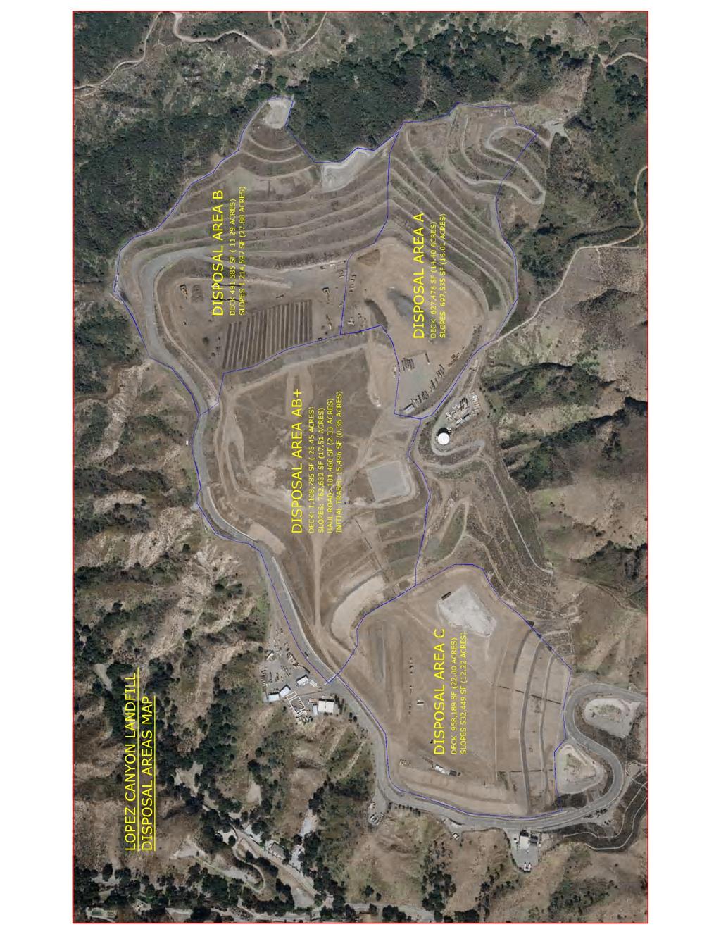
3 1. PURPOSE This Corrective Action Cost Estimate for Known or Reasonably Foreseeable Release to Water for the Lopez Canyon Landfill was prepared to meet the requirements of the Waste Discharge Requirement Permit (WDR) Revised Monitoring and Reporting Program under program (No. CI-5636) issued December 6, 2011 and Title 27 Section 22101(a) of the California Code of Regulations (CCR). In the revised WDR permit issued to the City of Los Angeles (City) Bureau of Sanitation (Bureau) on December 6, 2011 the California Regional Water Quality Control Board Los Angeles Region directed the City to submit before March 5, 2012 a Corrective Action Cost Estimate for Known or Reasonably Foreseeable Release to water pursuant to Section 22101(a) of the California Code of Regulations, Title 27 (27CCR) [shown below] (a) Water release corrective action estimate The operator shall provide a cost estimate for initiating and completing corrective action for all known or reasonably foreseeable releases from the solid waste landfill to water in accordance with the program required by the SWRCB pursuant to section 20380(b). This Corrective Action Cost Estimate for Known or Reasonably Foreseeable Release to Water report for Lopez Canyon Landfill meets the WDR and 27CCR requirements. 2. BACKGROUND 2.1. Site Information The Lopez Canyon Landfill is a 399-acre Class III disposal site (including seven acres leased from the U.S. Forest Service) of which approximately 166 acres were used for refuse disposal. This 166-acre disposal area is divided into four areas known as Disposal Areas A, B, AB+ and C, as shown in the Appendix. The landfill operating permit was not extended, and it ceased to accept refuse after July 1, The preliminary final grading plan reflects a maximum landfill elevation of 1,770 feet above mean sea level (including five feet of final cover) in accordance with the Conditional Use Permit (CUP) for the landfill, CUP No CU. All closure construction activities at the site are completed except final hydro-seeding of Disposal Area C. The Construction Quality Assurance (CQA) reports were approved by your office on October 31, A closure certification report together with the final as-built closure cost will be submitted to the RWQCB once the hydro-seeding is completed in early April
4 2.2. Geology The landfill is located in the foothills of the San Gabriel Mountains on the northeast rim of the San Fernando Valley. The landfill is mainly underlain by bedrock of the Tertiary Towsley Formation. The Towsley formation is composed predominantly of interbedded silt, shale, and sandstone of non-marine origin. Ground-water wells in the Towsley formation do not yield significant quantities of water and yield water of generally poor quantity. For this reason, the Towsley formation is not considered a water bearing formation by the California Department of Water Resources (DWR) [CDMG, 1973]. The northern-most part of the landfill property (not containing waste) is underlain by the Tertiary-Quaternary Saugus Formation. The Saugus formation is composed predominantly of massive sandstone and conglomerate bedrock. The Saugus formation is considered a water bearing interval in that wells in the Saugus formation readily yield useable quantities of good quality water. The bedrock formations beneath the landfill typically dip at an angle of approximately 50 to 65 degrees to the north. Quaternary marine terrace deposits of the Modelo formation are present locally near the southeastern boundary of the property but do not underlie the landfill footprint. The Modelo formation is composed primarily of low permeability shale and siltstone beds. The Modelo formation is not considered water bearing by DWR and may act as a hydraulic barrier between the landfill and the water bearing San Fernando Hydrogeologic Subunit to the south. Quaternary and Holocene alluvial deposits line the drainage channels and canyon bottoms. Talus deposits are present in places along the toes of steep rock outcrops Hydrogeology The bodies of water that could be potentially affected by the Lopez Canyon Sanitary Landfill include the ground water contained in the aquifer(s) beneath and adjacent to the landfill. The nature of these ground-water aquifer(s) are discussed in the following paragraphs. There are no permanent surface water bodies (e.g. rivers, streams, or lakes) in the immediate vicinity of the landfill, though the Bureau does monitor surface water run-off from the landfill. The landfill is located adjacent to the surface projection of the San Fernando Hydrogeologic Subunit of the Los Angeles - San Gabriel Hydrogeologic Unit. The ground water contained in the bedrock formation beneath the landfill is hydrogeologically isolated and does not connect to either the San Fernando Hydrogeologic Subunit to the south and west [RWQCB, 1991]. The Towsley formation, the bedrock geologic formation underlying the majority of the waste cells at the landfill, is not considered water bearing [Brown, 1975] as it is capable of producing only limited 2
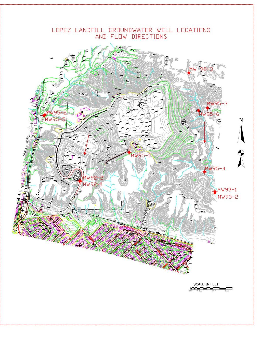
5 quantities of water high in dissolved solids. Thus the water contained in the Towsley formation has few beneficial uses due to both its limited quantities and its poor quality [Brown, 1975] Conceptual Hydrogeologic Model A conceptual hydrogeologic model for the landfill was formulated based on current ground-water elevations, available data regarding the hydrogeologic conditions in the vicinity of the landfill, and general hydrogeologic principles. In this conceptual model, the ground-water flow in the vicinity of the landfill is primarily due to infiltrating rainwater. This infiltrating rainwater follows one of two primary flow paths. In one case, the infiltrating water penetrates the alluvium and flows primarily along the bedrock-alluvium interface toward the canyon bottoms and then along the canyon bottoms toward the canyon mouths. In the second case, the infiltrating water flows within the vadose zone down the dip of relatively high permeability sandstone and conglomerate beds sandwiched between less pervious siltstone and shale beds until either hitting alluvium in the canyons or the ground-water table in the bedrock. In the first case, the alluvial ground water in Canyons A, B, and C percolates essentially vertically within the alluvium to the alluvium/bedrock interface. After reaching the alluvium/bedrock interface, the ground water then flows primarily along the alluvium/bedrock interface in the canyon bottoms into Lopez and Bartholomaus Canyons. The ground water then flows south towards the San Fernando Subunit of the Upper Los Angeles River Basin (ULARB). The ground-water flow direction is primarily dictated by subsurface geologic structure, by the pre-grading topography in the landfill area, and to some extent influenced by the present topography and surface cover. The disposal areas at the landfill are shown in Appendix 1. Based on the landfill topography before grading, an alluvial ground-water flow divide beneath the topographic divide between Disposal Area C and Disposal Areas A and B was incorporated into the conceptual hydrogeologic model. This ground-water flow divide was assumed to run north-south in the vicinity of Monitoring Well MW95-1. In the conceptual model, alluvial ground water beneath Disposal Area AB+ and Disposal Area C flows towards Lopez Canyon and alluvial ground water beneath Disposal Areas A and B flows towards Bartholomaus Canyon. As the alluvium in Canyons A, B, and C and in Lopez and Bartholomaus Canyons in the immediate vicinity of the landfill is derived from the Towsley formation (which is predominantly composed of claystone and siltstone), the alluvium in these canyons may be assumed to be rich in clay and silt sized particles and to have a low saturated hydraulic conductivity. 3
6 In the second case, some ground water infiltrates through the vadose zone down the dip of pervious strata to the water table. Some of the ground water in the alluvium may also percolate into the underlying bedrock of the canyon bottoms, or during dry periods, ground water may percolate out of the bedrock into the alluvium. In the bedrock, ground-water flows in response to the regional gradient, though it may be influenced to some extent by the bedding orientation and other structural features. In the conceptual hydrogeologic model formulated for the landfill vicinity, the regional ground-water gradient drives flow in the bedrock beneath the landfill in a southerly and westerly direction, from the San Gabriel Mountains into the San Fernando Subunit of the ULARB. The slow recovery of ground water in purged ground-water monitoring wells in both alluvial and bedrock ground-water monitoring wells [personal communication with Haydar Azzouz, GeoSyntec Consultants geologist] indicates that the saturated hydraulic conductivities of the alluvial and bedrock aquifers are low. Because the ground-water elevation in adjacent bedrock and alluvial ground-water monitoring wells are essentially equal, the alluvial and bedrock aquifers are assumed to be interconnected to some extent. The following general assumptions can be stated based on the hydrogeologic model and site observations discussed above: HM-1 HM-2 HM-3 HM-4 The uppermost aquifer beneath the landfill is located in the alluvium. Water in this aquifer flows along the alluvium/bedrock interface down the axes of the various canyons at the site, with some infiltration of ground water between the alluvium and the bedrock aquifers. Ground-water flow in the bedrock beneath the landfill may be influenced by alluvial flows and structural features, but is generally controlled by the regional gradient and flows in a southerly direction. The recovery of ground water in ground-water monitoring wells installed in the alluvium and bedrock is very slow, indicating that the hydraulic conductivity of these two aquifers is low. Thus, ground-water velocity is likely to be low in both aquifers. The depth of water in the alluvium aquifer is a function of the amount of rainfall that has occurred at the landfill in the recent past. 4
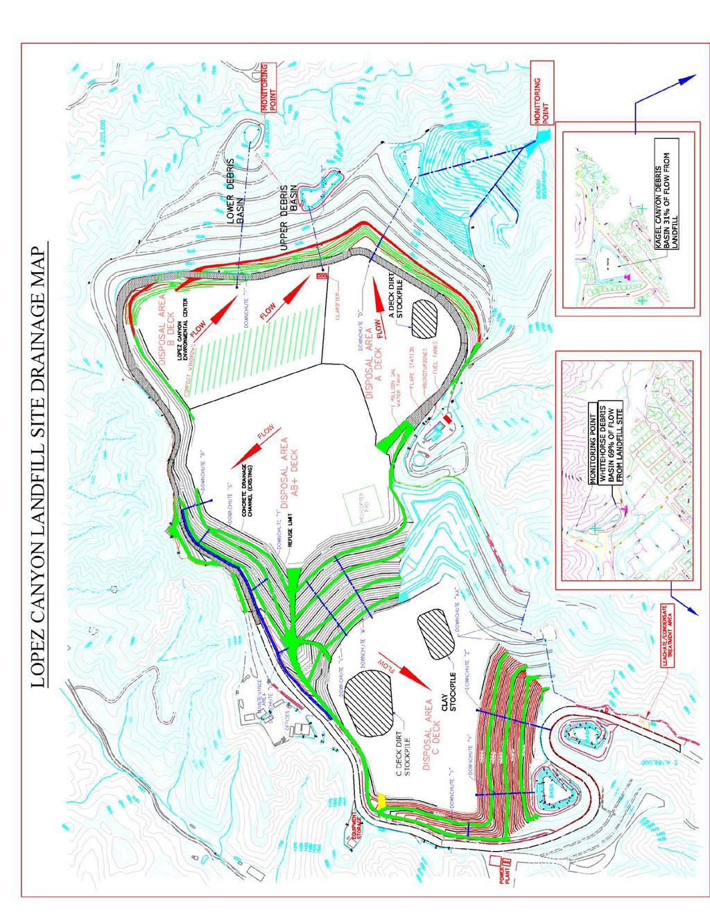
7 2.5. Seeps and Springs There are no known springs within a mile of the site. Four seeps were found at the site at various times when the landfill was open between 1975 and Three are now dry and one is collected and pumped into the Los Angeles sewer system. Three seeps have been detected in the Disposal Area C. All three seeps were located along the same sandstone conglomerate layer and appear to have originated from the same water source. The Bureau submitted to the RWQCB a notification memo for each of these seeps. All seeps in Disposal Area C were connected to the liner subdrain system to provide drainage under the liner. It is believed that the seeps are now dry because there has been no flow in the sub-drain system since One seep was detected in Disposal Area A on July 11, The seep water is contained in a tank. The seep water in the tank is automatically pumped into the sewer system Surface Water Surface water exits from the Lopez Landfill in three locations. The locations are South of A-canyon [at the bottom of A-canyon], East of B-Canyon [at the bottom of B-canyon], and South of C-canyon [below C-canyon at the white horse debris basin]. The tributary areas are A-canyon, B-canyon, and [AB+&C]-canyons. The aggregate watershed area with refuse under it is 166 acres then additional area on natural ground Regulatory Background The Lopez Canyon Landfill operated under Waste Discharge Requirements (WDR) Order No issued by the RWQCB. In August 1992, the Bureau revised the existing WDR and prepared a revised draft WDR to comply with revisions to Article 5, Chapter 15, Division 3, Title 23 (Article 5) of the California Code of Regulations (CCR), which became effective on 1 July 1991 [Law/Crandall, Inc. 1992]. The draft WDR included the development of water quality monitoring and response programs to detect, evaluate, and mitigate the potential release of contaminants from the Lopez Canyon landfill to the ground water, surface water, and the unsaturated (vadose) zone. The final WDR (Order No ) was approved in 1993 without the corrective financial assurance plans incorporated into the document. In November 2004 Order [No. R ] was approved. This WDR also had language regarding the Release Discovery Response. There was no required Corrective Action Cost Estimate for Known or Reasonably Foreseeable Release to Water in the Document. On September 16, 2010 the Bureau requested the RWQCB to modify the groundwater monitoring 5
8 requirements for all closed landfills owned and maintained by the City including Lopez Canyon. The Monitoring and Reporting Program (M&RP) was modified by the RWQCB on December 6, The following primary elements were added to the M&RP: 1) reduce the monitoring well network from 10 to 5 wells, 2) submission of a Corrective Action Cost Estimate for Known or Reasonably Foreseeable Release to Water, 3) after acceptance of the cost estimate the City will demonstrate that it can perform the Corrective Actions by demonstrating financial assurances according with 27 CCR sections et. Seq. 3. KNOWN OR FORESEEABLE WATER RELEASES There are three general types of releases [Release Scenairo-1 to Release Scenairo-3] that were selected as foreseeable at the Lopez Canyon Landfill site: Release Scenario-1 [Leachate] a subsurface release of leachate from Canyons A, B, AB+, or C. These releases would flow underground in a Southern direction. Detection of a release from the four canyons is very unlikely because historically there has been no detectable impact from the landfill in any of the groundwater wells since 1975 [37 years] when the landfill was opened. This may be because of the adequately sloped drainage areas reduce surface infiltration reducing the generation of leachate in the landfill and the low aquifer hydraulic conductivity lowers the subsurface flow velocity so the leachate is contained within the landfill boundary. The C-canyon is double lined with a geosynthetic liner reducing the potential for a release at that canyon. Release Scenario-2 [Fuel] a sub-surface release of gasoline or diesel from one of the underground tanks at the fueling station. This release would flow down gradient from the fuel station into the soil on the Southern perimeter of AB+ Canyon. This type of release is also very unlikely because of the early warning leak detection system and tank containment that has been installed at the site. Release Scenario-3 [Equipment Fluid] a surface release from material spilled onto one or multiple discharge tributaries [stormwater contamination]. There are three discharge locations at the site that collect stormwater from an area of 166 acres. This release scenario is very un-probable because any release would be treated with absorbent, contained and removed from the site so that it wouldn t contaminate the stormwater. 6
9 Table 1: Summary of Release Scenarios Release Scenario Discharge Area Probability 1. Leachate Groundwater Low 2. Fuel Groundwater Low 3. Equipment Fluid Surface Water Low 4. CORRECTIVE ACTIONS The corrective actions for the three (3) foreseeable releases are predicted to be as shown in Table 2. Table 2: Summary of Corrective Actions Release Scenario 1. Leachate Monitor, extract, and contain leachate using groundwater wells. 2. Fuel Dig out and dispose of Containment Structure, Tanks, and Contaminated Soil. 3. Equipment Fluid Contain, remove, and dispose of the contaminated soil. Release Scenario 1 would be the most complicated and capital intensive of the corrective actions. The area of the release would have to be determined and verified by installation of monitoring wells. Then extraction wells would be installed either underneath the refuse or on the refuse boundary. No treatment would be required since the landfill has access to the City of Los Angeles wastewater collection system. The extraction wells would create a cone of depression in the aquifer that would contain and extract the leachate. During the evaluation and feasibility phases it is estimated that three (3) monitoring wells would be installed to locate the release location. Then during the construction of the extraction wells five (5) wells are predicted to be installed. The leachate abatement network of five (5) groundwater wells would convey groundwater to the sewer through dedicated 2 diameter HDPE pipe. Two of the wells were predicted to be greater than 350 and would require electric power instead of pneumatic operation. The other pneumatic pumps would operate using existing air from the flare station at Lopez Canyon. Only Release Scenario 1 would require extensive use of a consultant for the Evaluation of the Monitoring and Reporting Program report and the Preliminary Engineering Feasibility report. The other Releases probably wouldn t require a consultant. 7
10 For scenario 2 a fuel release, a contractor would be brought in to excavate and remove the structures and contaminated soil. Release Scenario 3 the equipment fluid spilling on the landfill surface would be contained, dug up, and disposed of to keep it out of contact with stormwater runoff. 5. CORRECTIVE ACTION COST ESTIMATE 5.1. Leachate Abatement Table 3: Leachate Release Corrective Action Cost Estimate Deliverable Estimated Cost 1-Evaluation of Monitoring and Reporting Program $ 86,086 2-Preliminary Engineering Feasibility Study $276,253 3-Capital Cost for Corrective Action Construction (3 rd party) $532,258 4-Operation Cost for Corrective Action (3 rd party) $692,800 Total Cost $1,587,398 The itemized costs are shown in the appendix. These costs are predicted using a 3 rd party contractor. The actual event would probably be performed by City crews and significantly lower the items 3 & 4 Capital and Operation costs respectively. The consultant costs would also probably be less, but a very conservative approach was used that probably represents the upper bound of cost for a corrective event Fuel Abatement For fuel underground storage tank clean-up the Congressional Research Service (CRS) performed a study for the United States congress Leaking Underground Storage Tanks (USTS) Prevention and Cleanup, May 18, 2010 [Doc ]. This study found that the average clean-up for all states in the United States was $127,000 and the highest 10 state average was $173, Equipment Fluid Any fluid from equipment will be contained and disposed for less than $20, CONCLUSION The estimated cost range for the most probable corrective actions as outlined is $20k - $1.6 million. The maximum cost is established by the highest treatment option which is the landfill leachate abatement corrective action for $1,587,398. 8
11 Table 4: Summary of Corrective Action Cost Estimates Release Scenario Cost Estimate for Abatement 1-Leachate Release to Groundwater $1,587,398 2-Fuel Tank Release to Soil $173, Equipment Fluid Release to Surface Water $20,000 9
12 Appendix 1: Site Map 10
13 11
14 12
15 13
16 Appendix 2: Leachate Corrective Action Cost Estimate 14
17 Corrective Action Capital and Operation Cost Estimate 15
18 16
19 17
20 Appendix 3: Equipment Specifications 18
CITY OF MONTCLAIR Montclair Civic Center 5111 Benito Street Montclair, CA 91763
 CITY OF MONTCLAIR Montclair Civic Center 5111 Benito Street Montclair, CA 91763 I. Introduction Water Quality A National, State, and Local Concern Throughout the United States, many rivers, creeks, streams,
IV. ENVIRONMENTAL IMPACT ANALYSIS G. HYDROLOGY/WATER QUALITY
 IV. ENVIRONMENTAL IMPACT ANALYSIS G. HYDROLOGY/WATER QUALITY ENVIRONMENTAL SETTING The project site is located in the Wilshire community of the City of Los Angeles and is bound by S. Wetherly Drive to
Groundwater 3/16/2010. GG22A: GEOSPHERE & HYDROSPHERE Hydrology
 GG22A: GEOSPHERE & HYDROSPHERE Hydrology Definitions Groundwater Subsurface water in soil or rock that is fully saturated. Aquifer Contains enough saturated material to yield significant quantities of
CHAPTER 13 OUTLINE The Hydrologic Cycle and Groundwater. Hydrologic cycle. Hydrologic cycle cont.
 CHAPTER 13 OUTLINE The Hydrologic Cycle and Groundwater Does not contain complete lecture notes. To be used to help organize lecture notes and home/test studies. Hydrologic cycle The hydrologic cycle is
LANDFILL CLOSURE PLAN ENTERGY ARKANSAS, INC. INDEPENDENCE PLANT CLASS 3N CCR LANDFILL PERMIT NO S3N-R2 AFIN
 LANDFILL CLOSURE PLAN ENTERGY ARKANSAS, INC. INDEPENDENCE PLANT CLASS 3N CCR LANDFILL PERMIT NO. 0200-S3N-R2 AFIN 32-00042 OCTOBER 12, 2016 LANDFILL CLOSURE PLAN ENTERGY ARKANSAS, INC. INDEPENDENCE PLANT
Las Pulgas Landfill Phase I Clean Closure Marine Corps Base Camp Pendleton, Ca
 Las Pulgas Landfill Phase I Clean Closure Marine Corps Base Camp Pendleton, Ca SWANA Western Regional Conference April 2013 Presented by Marielle Coquia, P.E. Agenda Project Overview Las Pulgas Landfill
Albemarle County Hydrogeologic Assessment Summary Report
 Albemarle County Hydrogeologic Assessment Summary Report Phase II Groundwater Availability and Sensitivity Assessment with Proposed Groundwater Assessment Standards Presented To: County of Albemarle Department
HYDROGEOLOGY OF THE HUMBOLDT RIVER BASIN, IMPACTS OF OPEN-PIT MINE DEWATERING AND PIT LAKE FORMATION
 HYDROGEOLOGY OF THE HUMBOLDT RIVER BASIN, IMPACTS OF OPEN-PIT MINE DEWATERING AND PIT LAKE FORMATION June, 2015 Tom Myers, Ph.D., Hydrologic Consultant, Reno NV tom_myers@charter.net Prepared for: Progressive
East Maui Watershed Partnership Adapted from Utah State University and University of Wisconsin Ground Water Project Ages 7 th -Adult
 INTRODUCTION What is groundwater? Water contained in saturated soil and rock materials below the surface of the earth. It is not NEW water, but is recycled water through the hydraulic cycle. The source
Characteristics of Land Resources
 Chapter Chapter 1 Characteristics of Land Resources The geology, soils and topography of Woodford County T he geology, soils and topography of an area are important to the community planning process for
Infiltration Guidelines
 Appendix E Infiltration Guidelines As a stormwater management method, infiltration means retaining or detaining water within soils to reduce runoff. Infiltration can be a cost-effective method to manage
Ottumwa Generating Station Project No Closure Plan for Existing CCR Revision: 0 Surface Impoundments TABLE OF CONTENTS
 Surface Impoundments Page No. i TABLE OF CONTENTS 1. INTRODUCTION... 1 2. PROPOSED CCR IMPOUNDMENTS CLOSURE PROCEDURE... 3 3. PROPOSED COVER SYSTEM... 4 4. ESTIMATED MAXIMUM INVENTORY OF CCR... 4 5. ESTIMATED
Groundwater Earth 9th Edition Chapter 17 Mass wasting: summary in haiku form Importance of groundwater Importance of groundwater
 1 2 3 4 5 6 7 8 9 10 11 Groundwater Earth 9 th Edition Chapter 17 Geology 100 Mass wasting: summary in haiku form The grass is greener over the septic system said Erma Bombeck. Importance of groundwater
GY 111 Lecture Note Series Groundwater and Hydrogeology
 GY 111 Lecture Notes D. Haywick (2008-09) 1 GY 111 Lecture Note Series Groundwater and Hydrogeology Lecture Goals A) The hydrologic cycle B) Groundwater dynamics C) Mapping groundwater (done in class not
David Miller, P.E.- Atlanta. The New Coal Ash Regulations Wednesday, May 6, 2015
 David Miller, P.E.- Atlanta The New Coal Ash Regulations Wednesday, May 6, 2015 Overview of CCR Management & Regulations Subtitle D Requirements & Compliance Schedule Non-Utility Boilers Beneficial Reuse
Groundwater. Groundwater Movement. Groundwater Movement Recharge: the infiltration of water into any subsurface formation.
 On March 22, 2014, a major landslide occurred near Oso, Washington. Death toll currently at 30, with 15 still missing. Groundwater Before and After Swipe http://bit.ly/pen1jt N. Fork Stillaguamish River
Appendix G Preliminary Hydrology Study
 Appendix G Preliminary Hydrology Study Preliminary Hydrology Study VESTING TTM 72608 Long Beach, CA Prepared for: The Long Beach Project, LLC 888 San Clemente, Suite 100 New Port Beach, CA May 28, 2014
Groundwater basics. Groundwater and surface water: a single resource. Pore Spaces. Simplified View
 Groundwater and surface water: a single resource Santa Cruz River, Tucson Groundwater basics Groundwater is water found within the pore spaces of geologic material beneath the surface of the Earth. It
Alternative Futures for the City of La Paz, Mexico
 O N T H E G R O U N D Alternative Futures for the City of La Paz, Mexico Caroline Dragoo University of Arizona and Robert Faris Harvard University La Paz, Mexico is working hard not to turn into Cabo San
DEPARTMENT OF ENVIRONMENTAL RESOURCES REVIEW NOTICE
 DEPARTMENT OF ENVIRONMENTAL RESOURCES REVIEW NOTICE This report, prepared by outside consultants, has been reviewed by the Department of Environmental Resources and approved for publication. The contents
Overview. Students will...
 Overview Students will... Understand the interaction between ground water and surface water. Observe the difference between a permeable layer and an impermeable layer in an aquifer. See how water is stored
Groundwater Monitoring Requirements of the CCR Rule What s Next?
 2017 World of Coal Ash (WOCA) Conference in Lexington, KY - May 9-11, 2017 http://www.flyash.info/ Groundwater Monitoring Requirements of the CCR Rule What s Next? Thomas A. Mann, PE SynTerra Corporation,
Groundwater. Chapter 10 11/22/2011. I. Importance of groundwater
 Groundwater Chapter 10 I. Importance of groundwater A. Groundwater is water found in the pores of soil and sediment, plus narrow fractures in bedrock B. Where is fresh water - 2 % of all water is fresh
Memorandum. Introduction. Carl Einberger Joe Morrice. Figures 1 through 7
 Memorandum TO: Michelle Halley, NWF DATE: October 9, 2007 FROM: Carl Einberger Joe Morrice PROJ. NO.: 9885.000 CC: Project File PROJ. NAME: National Wildlife Federation ATTACHMENTS: Tables 1 through 6
Design and Operation of Landfills
 Design and Operation of Landfills Soils and hydrogeology Site selection criteria Site layout and landfill operations Liner design Water balance Biological reactions in landfills Leachate quality Gas production
Run-on and Run-off Control System Plan
 Run-on and Run-off Control System Plan SWEPCO John W. Turk, Jr. Power Plant Fulton, Arkansas Permit No. 0311-S3N-R1 AFIN: 29-00506 October 2016 Terracon Project No. 35167133 Prepared for: SWEPCO 3711 Highway
E. STORMWATER MANAGEMENT
 E. STORMWATER MANAGEMENT 1. Existing Conditions The Project Site is located within the Lower Hudson Watershed. According to the New York State Department of Environmental Conservation (NYSDEC), Lower Hudson
San Mateo Plain Groundwater Basin Assessment Stakeholder Workshop #7 9 NOVEMBER 2017
 San Mateo Plain Groundwater Basin Assessment Stakeholder Workshop #7 9 NOVEMBER 2017 PRESENTATION OVERVIEW Introductions Project Overview Stakeholder Outreach Summary Phase 2 Updates Modeling Activities
global distribution of water!
 groundwater! hydrologic cycle! 2 global distribution of water! Source Volume Percent Ocean 97.2000 Glaciers and other ice 2.1500 Ground Water 0.6100 Lakes fresh 0.0090 saline 0.0080 Soil Moisture 0.0050
4.8. Subsurface Infiltration
 4.8. Subsurface Infiltration Subsurface infiltration systems are designed to provide temporary below grade storage infiltration of stormwater as it infiltrates into the ground. Dry wells, infiltration
3G. Hydrology and Water Quality
 INTRODUCTION This chapter assesses the potential impacts to surface water hydrology, surface water quality, groundwater hydrology, and groundwater quality resulting from the development of the proposed
Environmental Management Chapter ALABAMA DEPARTMENT OF ENVIRONMENTAL MANAGEMENT WATER DIVISION - WATER QUALITY PROGRAM ADMINISTRATIVE CODE
 Environmental Management Chapter 335-6-9 ALABAMA DEPARTMENT OF ENVIRONMENTAL MANAGEMENT WATER DIVISION - WATER QUALITY PROGRAM ADMINISTRATIVE CODE CHAPTER 335-6-9 SURFACE MINING RULES TABLE OF CONTENTS
Prepared For: Town of Castle Valley, Utah
 HYDROLOGIC ASSESSMENT OF THE SURFACE WATER AND GROUNDWATER RESOURCES OF CASTLE VALLEY, UTAH: PART 2: HESA-BASED SITING OF CULINERY WELL FOR TOWN OF CASTLE VALLEY Authors: Dr. Kenneth E. Kolm, Hydrologic
THE ABATEMENT PLAN. beneficial abatement plan. For the purpose of defining the pollution potential of surface waters
 THE ABATEMENT PLAN GENERAL PLAN Preventing surface waters from entering deep mine workings apparently offers the most beneficial abatement plan. For the purpose of defining the pollution potential of surface
TABLE OF CONTENTS 4.17 UTILITIES AND SERVICE SYSTEMS...
 TABLE OF CONTENTS 4.17 UTILITIES AND SERVICE SYSTEMS... 4.17-1 4.17.0 Introduction... 4.17-1 4.17.1 Methodology... 4.17-2 4.17.2 Existing Conditions... 4.17-2 4.17.3 Impacts... 4.17-4 4.17.4 Applicant-Proposed
NATURAL FEATURES, LAND SUITABILITY FOR DEVELOPMENT AND DEVELOPMENT CONCERNS
 East Central Wayne County Comprehensive Plan - Natural Features, Land Suitability Page 170 NATURAL FEATURES, LAND SUITABILITY FOR DEVELOPMENT AND DEVELOPMENT CONCERNS Introduction The residents of East
Determination of Design Infiltration Rates for the Sizing of Infiltration based Green Infrastructure Facilities
 Determination of Design Infiltration Rates for the Sizing of Infiltration based Green Infrastructure Facilities 1 Introduction This document, developed by the San Francisco Public Utilities Commission
Bioreactor Landfill Design
 Bioreactor Landfill Design Timothy Townsend, PhD, PE Department of Environmental Engineering Sciences University of Florida ttown@ufl.edu Bioreactor Landfill Design Modern landfill design entails many
(this cover page left intentionally blank)
") 4. Siting the Well (this cover page left intentionally blank) 4. Siting the Well Chapter Table of Contents Chapter Table of Contents Chapter Description... 4 Regulatory Requirements Well Siting... 4 Relevant
4. Siting the Well (this cover page left intentionally blank) 4. Siting the Well Chapter Table of Contents Chapter Table of Contents Chapter Description... 4 Regulatory Requirements Well Siting... 4 Relevant
Issue paper: Aquifer Water Balance
 Issue paper: Aquifer Water Balance 1. Introduction And Background 1.1. Purpose and Scope The population in Kitsap County has grown rapidly in recent years and is expected to increase substantially in the
4.8. Subsurface Infiltration
 4.8. Subsurface Infiltration Subsurface infiltration systems are designed to provide temporary below grade storage infiltration of storm water as it infiltrates into the ground. Dry wells, infiltration
Additional criteria for approval of sanitary landfill facility permit to install applications.
 3745-27-07 Additional criteria for approval of sanitary landfill facility permit to install applications. (A) General criteria. The director shall not approve any permit to install application for a sanitary
Leachate Management Leachate Control and Collection
 Leachate Management Leachate Control and Collection Leachate Collection Sanitary landfills have leachate collection and removal system above liner At un-lined landfills and dump sites Perimeter Ditch -
Closure Plan Ash Disposal Area PGE Boardman Power Plant
 FIRST ISSUE REVISION 0 Closure Plan Ash Disposal Area PGE Boardman Power Plant Prepared for Portland General Electric September 2015 2020 SW 4th Avenue, Suite 300 Portland, Oregon 97201 This document was
Awesome Aquifers A DEMONSTRATION. THE GROUNDWATER FOUNDATION
 Awesome Aquifers A DEMONSTRATION THE GROUNDWATER FOUNDATION www.groundwater.org Groundwater is water found underground in the spaces and cracks between rocks, sand, soil and clay. Groundwater is stored
4.6 - Hydrology and Water Quality
 City of Wasco - Wasco Center Walmart Hydrology and Water Quality 4.6 - Hydrology and Water Quality 4.6.1 - Introduction This section provides an evaluation of hydrology and water quality. The analysis
Freshwater. 260 Points Total
 9 SURFACE WATER SECTION 9.1 Surface Water Movement In your textbook, read about surface water and the way in which it moves sediment. Complete each statement. (13 points) 1. An excessive amount of water
Erosion & Sedimentation Control Policy
 Issue Date 10/22/2010 Page 1 of 8 Erosion & Sedimentation Control Policy Introduction: Soil erosion is the removal of soil by water, wind, ice or gravity and sediment deposition occurs when the rate of
STORMWATER MANAGEMENT. 158 Attachment 2. Borough of Perkasie
 158 Attachment 2 Borough of Perkasie Appendix B Site Soil Evaluation and Soil Infiltration Testing Source: Pennsylvania Stormwater Best Management Practice Manual, December 2006. SITE SOIL EVALUATION AND
2015 ANNUAL ENGINEERING INSPECTION REPORT ENTERGY INDEPENDENCE PLANT CLASS 3N LANDFILL PERMIT NO S3N-R2 AFIN:
 2015 ANNUAL ENGINEERING INSPECTION REPORT ENTERGY INDEPENDENCE PLANT CLASS 3N LANDFILL PERMIT NO. 0200-S3N-R2 AFIN: 32-00042 JANUARY 15, 2016 ENTERGY INDEPENDENCE PLANT CLASS 3N LANDFILL 2015 ANNUAL ENGINEERING
Introduction. Welcome to the Belgium Study Abroad Program. Courses:
 Introduction Welcome to the Belgium Study Abroad Program Courses: AGSM 335: Soil and Water Management BAEN 460: Principals of Environmental Hydrology BAEN 460 / AGSM 335 Combined lecture and HW sessions
BUILDING A WATERSHED MODEL
 BUILDING A WATERSHED MODEL OBJECTIVES Define a watershed and describe how it functions Identify that students live in a watershed within the San Antonio River Basin TOPICS Watersheds Runoff TEKS ALIGNMENT
CORBIN AND NORDHOFF IV. ENVIRONMENTAL IMPACT ANALYSIS ENV EIR F. HYDROLOGY
 F. HYDROLOGY ENVIRONMENTAL SETTING Project Site The Project Site is located at 19601 Nordhoff Street in the Chatsworth area of the City of Los Angeles, California, within the Chatsworth - Porter Ranch
Applying landforming to reclamation: A case study in Central Appalachia
 Applying landforming to reclamation: A case study in Central Appalachia Leslie Hopkinson, John Quaranta April 12, 2017 Department of Civil and Environmental Engineering West Virginia University WEST VIRGINIA
Water Resources on PEI: an overview and brief discussion of challenges
 Water Resources on PEI: an overview and brief discussion of challenges Components: Components and links Atmospheric water Surface water (including glacial water) Groundwater Links: Precipitation (atm(
LANDFILL POST-CLOSURE PLAN ENTERGY ARKANSAS, INC. INDEPENDENCE PLANT CLASS 3N CCR LANDFILL PERMIT NO S3N-R2 AFIN
 LANDFILL POST-CLOSURE PLAN ENTERGY ARKANSAS, INC. INDEPENDENCE PLANT CLASS 3N CCR LANDFILL PERMIT NO. 0200-S3N-R2 AFIN 32-00042 OCTOBER 12, 2016 LANDFILL POST-CLOSURE PLAN ENTERGY ARKANSAS, INC. INDEPENDENCE
The Hydrological Cycle. Hydrological Cycle. Definition of Terms. Soils and Water, Spring Lecture 7, The Hydrological Cycle 1
 The Hydrological Cycle Water vapor helps warm up the earth Evaporation+Transpiration Chemical Spill Runoff To Oceans Water potential, atmosphere Hydrological Cycle Transpiration, T Atmospheric pool Interception
Groundwater Master Plan Update: Emergency Groundwater Supply Analysis & Water Quality Discussion
 Groundwater Master Plan Update: Emergency Groundwater Supply Analysis & Water Quality Discussion BPU Study Session October 4, 2012 Presentation Outline Groundwater Quality Discussion Basin Overview Groundwater
GROUNDWATER RESOURCE MANAGEMENT FUNDAMENTALS: GROUNDWATER BASIN CONNECTIVITY. Open-File Report May 2014
 GROUNDWATER RESOURCE MANAGEMENT FUNDAMENTALS: GROUNDWATER BASIN CONNECTIVITY Open-File Report 2014-03 May 2014 from CA Department of Water Resources, 1989 THIS REPORT IS PRELIMINARY AND IS SUBJECT TO MODIFICATION
LANDFILL CLOSURE PLAN PLUM POINT ENERGY STATION CLASS 3N CCR LANDFILL PERMIT NO S3N AFIN:
 LANDFILL CLOSURE PLAN PLUM POINT ENERGY STATION CLASS 3N CCR LANDFILL PERMIT NO. 0303-S3N AFIN: 47-00461 OCTOBER 14, 2016 LANDFILL CLOSURE PLAN PLUM POINT ENERGY STATION CLASS 3N CCR LANDFILL PERMIT NO.
Green Station CCR Surface Impoundment Sebree Generating Station Address: 9000 Highway 2096 Robards, Kentucky 42452
 Big Rivers Electric Corporation Disposal of Coal Combustion Residuals (CCR) from Electric Utilities Final Rule CCR Impoundment Groundwater Monitoring System and Statistical Methods Assessment and Certification
Jacobi, Toombs, and Lanz, Inc.
 Area 5: Blackiston Mill Road at Dead Man's Hollow Flooding Assessment Jacobi, Toombs, and Lanz, Inc. This document summarizes an assessment of drainage and flooding concerns and provides recommendations
FACT SHEET GENERAL KPDES PERMIT FOR STORM WATER POINT SOURCE DISCHARGES CONSTRUCTION ACTIVITIES
 FACT SHEET GENERAL KPDES PERMIT FOR STORM WATER POINT SOURCE DISCHARGES CONSTRUCTION ACTIVITIES 1. COVERAGE UNDER THIS GENERAL PERMIT Area of Coverage: This permit covers all areas of the Commonwealth
Novel Modeling Approach to Understand the Fate of Infiltrated Water at Green Stormwater Infrastructure in Philadelphia, PA
 Novel Modeling Approach to Understand the Fate of Infiltrated Water at Green Stormwater Infrastructure in Philadelphia, PA Matt Gamache 1*, Daniel O Rourke 2, and Mark Maimone 3 1 CDM Smith, Boston, Massachusetts
901 - TEMPORARY EROSION AND POLLUTION CONTROL SECTION 901 TEMPORARY EROSION AND POLLUTION CONTROL
 SECTION 901 TEMPORARY EROSION AND POLLUTION CONTROL 901.1 DESCRIPTION Install, maintain and remove temporary erosion and pollution control devices as required during the construction of the project. BID
Groundwater in the Santa Rosa Plain
 . Groundwater in the Santa Rosa Plain Marcus Trotta, PG, CHg Principal Hydrogeologist Sonoma County Water Agency Santa Rosa Plain Groundwater Sustainability Agency October 12, 2017 www.sonomacountywater.org
Introduction to Groundwater. Photo: Joanne Offer/The IRC
 Introduction to Groundwater Photo: Joanne Offer/The IRC Groundwater Groundwater is water that has permeated or percolated into the ground. It is an important part of the water cycle. Groundwater is an
AQUIFERS OF THE SAN ANTONIO RIVER BASIN
 AQUIFERS OF THE SAN ANTONIO RIVER BASIN OBJECTIVES Explain what an aquifer is Identify the major aquifers located in the San Antonio River Basin Explain the difference between porosity and permeability
MENDOCINO WATER RESOURCES AND WATER CONSERVATION
 MENDOCINO WATER RESOURCES AND WATER CONSERVATION MENDOCINO S LIMITED GROUNDWATER SUPPLY The Town of Mendocino is located on the Mendocino Headlands along the Pacific Coast in Mendocino County, California
Alamogordo Desalination Project
 Alamogordo Desalination Project 2015 Multi State Salinity Conference Robert Fowlie, PE, BCEE February 19, 2015 Alamogordo Regional Water Supply Project Existing Water Sources Surface Water City has 5400
Surface Water and Non-Wetland Surface Waters Delineation and Classification pursuant Chapter F.A.C.
 Surface Water and Non-Wetland Surface Waters Delineation and Classification pursuant Chapter 62-340 F.A.C. What are Waters? 373.019 F.S. Definitions (20) Water or waters in the state means any and all
1.0 Introduction. 1.1 The Stream Depletion Issue. 1.2 Purpose of the Guidelines
 Guidelines for the Assessment of Groundwater Abstraction Effects on 1.0 Introduction 1.1 The Stream Depletion Issue The management of water resources has often focussed on groundwater and surface water
1. Apply knowledge of the controlling variables for groundwater flow. 2. Demonstrate groundwater flow direction based on hydraulic head observations.
 .9-12 HYDRAULIC HEAD SUBJECTS: TIME: Science (Physical Science, Physics), Math 1 class period MATERIALS: Copies of student sheets and background information OBJECTIVES The student will do the following:
Closure Plan Brame Fly Ash Pond
 Brame Fly Ash Pond CLECO Corporation Rodemacher Unit 2 Project No. 90965 Revision 0 10/14/2016 Brame Fly Ash Pond prepared for CLECO Corporation Rodemacher Unit 2 Rapides Parish, Louisiana Project No.
SOUTH FLORIDA WATER MANAGEMENT DISTRICT. Question 13: Wetlands
 SOUTH FLORIDA WATER MANAGEMENT DISTRICT Question 13: Wetlands 1. The wetland responses and topographical data provided in the ADA for the 520- acre project site are conceptual in nature. The referenced
Wisconsin s Buried Treasure
 Wisconsin s Buried Treasure Kevin Masarik Center for Watershed Science and Education Through the University of Wisconsin-Extension, all Wisconsin people can access University resources and engage in lifelong
ONSITE WASTEWATER TREATMENT SYSTEM (OWTS)
") INFORMATION BULLETIN / PUBLIC - BUILDING CODE REFERENCE NO.: LABC 106.4 Effective: 01-01-2014 DOCUMENT NO.: P/BC 2017-027 Revised: 12-15-2017 Previously Issued As: P/BC 2014-027 ONSITE WASTEWATER TREATMENT
INFORMATION BULLETIN / PUBLIC - BUILDING CODE REFERENCE NO.: LABC 106.4 Effective: 01-01-2014 DOCUMENT NO.: P/BC 2017-027 Revised: 12-15-2017 Previously Issued As: P/BC 2014-027 ONSITE WASTEWATER TREATMENT
DESIGN PARAMETERS FOR MULTI-PHASE EXTRACTION SYSTEMS USING UNSATURATED AND SATURATED SOIL PROPERTIES
 DESIGN PARAMETERS FOR MULTI-PHASE EXTRACTION SYSTEMS USING UNSATURATED AND SATURATED SOIL PROPERTIES Todd White, M.Sc., P.Geol. and Douglas A. Sweeney, M.Sc., P.Eng. SEACOR Environmental Inc. INTRODUCTION
Effect of the Underlying Groundwater System on the Rate of Infiltration of Stormwater Infiltration Structures.
 Effect of the Underlying Groundwater System on the Rate of Infiltration of Stormwater Infiltration Structures. Presented at: Storm Water Infiltration & Groundwater Recharge A Conference on Reducing Runoff
Preliminary Drainage Analysis
 Preliminary Drainage Analysis Tanimura and Antle Employee Housing Town of Spreckels County of Monterey, California LIB150205 May 29, 2015 Prepared For: Tanimura and Antle Produce Prepared By: 9699 Blue
Campbell River Environmental Committee 2353 Dolly Varden Road Campbell River, BC V9W 4W5 (Via ) Attention: Leona Adams
 Attention: Leona Adams") October 17, 2016 16-27 Campbell River Environmental Committee 2353 Dolly Varden Road Campbell River, BC V9W 4W5 (Via email) Attention: Leona Adams Re: Review of Upland Excavating Landfill Application Technical
October 17, 2016 16-27 Campbell River Environmental Committee 2353 Dolly Varden Road Campbell River, BC V9W 4W5 (Via email) Attention: Leona Adams Re: Review of Upland Excavating Landfill Application Technical
How does groundwater get in the earth? Where does it come from?
 What is Groundwater? How does groundwater get in the earth? Where does it come from? Groundwater begins as rain or snow that falls to the ground. This is called precipitation. Only a small portion of this
Chapter 21 Stormwater Management Bylaw
 Chapter 21 Stormwater Management Bylaw SECTION 1. PURPOSE The purpose of this Bylaw is to: implement the requirements of the National Pollutant Discharge Elimination System (NPDES) General Permit for Storm
CONSTRUCTION RULES TABLE OF CONTENTS
 CONSTRUCTION RULES TABLE OF CONTENTS RULE 1 TITLE... 3 RULE 2 AUTHORITY... 3 RULE 3 SCOPE OF RULES... 3 RULE 4 PURPOSE OF RULES... 4 RULE 5 DEFINITIONS... 5 RULE 6 GENERAL RULES... 14 RULE 7 LICENSING...
SUBSURFACE INFILTRATION SYSTEM DESCRIPTION. Alternative Names: Sump, Drywell, Infiltration Trench, Infiltration Galleries, Leach Fields
 4.1-d SUBSURFACE INFILTRATION SYSTEM Alternative Names: Sump, Drywell, Infiltration Trench, Infiltration Galleries, Leach Fields BMP DESIGN APPROACH Pollutant Source Control Hydrologic Source Control Stormwater
Application for Gas Exploration and Production
 1800 Washington Blvd. Suite 655 Baltimore Maryland 21230 Application for Gas Exploration and Production This application is to be used to obtain a permit to Drill and Operate a well, within the State for
PROJECT NO A. ISSUED: February 29, 2016
 INTERPRETIVE REPORT FOR INFILTRATION SYSTEM DESIGN, PROPOSED VILLA VERONA APARTMENT COMMUNITY, ASSESSOR S PARCEL NUMBERS 311-040-015, 311-040-021, 311-040-024, 311-040-026 AND 311-040-013, LOCATED ON THE
Proposed New 18 CFR Part Hydraulic Fracturing in Shale and Other Formations:
 Proposed New 18 CFR Part 440 - Hydraulic Fracturing in Shale and Other Formations: SUBCHAPTER B SPECIAL REGULATIONS * * * * PART 440 HYDRAULIC FRACTURING IN SHALE AND OTHER FORMATIONS Sec. 440.1 Purpose,
CLOSURE AND POST-CLOSURE CARE PLAN JAMES RIVER POWER STATION UTILITY WASTE LANDFILL CITY UTILITIES OF SPRINGFIELD, MISSOURI
 CLOSURE AND POST-CLOSURE CARE PLAN JAMES RIVER POWER STATION UTILITY WASTE LANDFILL CITY UTILITIES OF SPRINGFIELD, MISSOURI INITIAL PREPARATION DATE: October 11, 2016 TABLE OF CONTENTS 1. CERTIFICATION
Stormwater Control Plan Report
 Stormwater Control Plan Report (SWCP) HILLSDALE TERRACE 2700, 2728, 2790 South El Camino Real San Mateo, CA APN: 039-352-060, 039-352-070, 039-352-090 Stormwater Control Plan Report February 18, 2015 Prepared
Hydrologic Study Report for Single Lot Detention Basin Analysis
 Hydrologic Study Report for Single Lot Detention Basin Analysis Prepared for: City of Vista, California August 18, 2006 Tory R. Walker, R.C.E. 45005 President W.O. 116-01 01/23/2007 Table of Contents Page
August 15, 2006 (Revised) July 3, 2006 Project No A
 July 3, 2006 Project No A") August 15, 2006 (Revised) July 3, 2006 Project No. 01-05-0854-101A Mr. David Reed, P.E. Protean Design Group 100 East Pine Street, Suite 306 Orlando, Florida 32801 Preliminary Soil Survey Report Polk Parkway
August 15, 2006 (Revised) July 3, 2006 Project No. 01-05-0854-101A Mr. David Reed, P.E. Protean Design Group 100 East Pine Street, Suite 306 Orlando, Florida 32801 Preliminary Soil Survey Report Polk Parkway
Preliminary Stormwater Quality Mitigation Report
 Preliminary Stormwater Quality Mitigation Report MGA Chatsworth Campus 20000 Prairie Street Chatsworth, CA TUSTIN 17782 17th Street Suite 200 Tustin, CA 92780-1947 714.665.4500 Fax 714.665.4501 LOS ANGELES
DRAINAGE & DESIGN OF DRAINAGE SYSTEM
 Drainage on Highways DRAINAGE & DESIGN OF DRAINAGE SYSTEM P. R.D. Fernando Chartered Engineer B.Sc.(Hons), M.Eng. C.Eng., MIE(SL) Drainage Requirement of Highway Drainage System Introduction Drainage means
ENVIRONMENTAL PROTECTION AT THE MANAGED SOLID WASTE LANDFILL
 ENVIRONMENTAL PROTECTION AT THE MANAGED SOLID WASTE LANDFILL Prepared by: EXECUTIVE SUMMARY 10220 Old Columbia Road, Suite A Columbia, Maryland 21046 Document No. MD10186 26 MARCH 2010 ACKNOWLEDGEMENTS
STORMWATER AND EROSION CONTROL PERMIT
 STORMWATER MANAGEMENT AND EROSION CONTROL PERMIT INSTRUCTIONS AND INFORMATION Any project that involves the disturbance of ANY quantity of land requires the applicant to receive approval for the project
Hydrologic cycle, runoff process
 Hydrologic cycle, runoff process Motivation of hydrological modelling What happens at the catchment and in the stream when it rains? How does the increased/decreased runoff affect (not only) the landowners
Manure Storage for Environmental Management Systems
 WiMStor01 MStor Manure Storage for Environmental Management Systems Key: 1)Low Risk 2)Low-Moderate Risk 3)Moderate-High Risk 4)High Risk Location of Manure Storage Are the manure storage facilities in
Technical Memorandum Mine Plan of Operations Stormwater Assessment
 Tucson Office 3031 West Ina Road Tucson, AZ 85741 Tel 520.297.7723 Fax 520.297.7724 www.tetratech.com Technical Memorandum Mine Plan of Operations Stormwater Assessment To: Kathy Arnold From: David R.
Groundwater Pollution at the Existing Puente Hills Landfill. Testimony Presented to LA County Sanitation Districts
 Groundwater Pollution at the Existing Puente Hills Landfill Testimony Presented to LA County Sanitation Districts G. Fred Lee, Ph.D., D.E.E. and Anne Jones-Lee, Ph.D. G. Fred Lee & Associates El Macero,