Newton Creek & Hog Island Inlet Contaminated Sediment Remediation Project
|
|
|
- Brendan Rose
- 5 years ago
- Views:
Transcription


1 Newton Creek & Hog Island Inlet Contaminated Sediment Remediation Project

2 The St. Louis River is the largest U.S. tributary to Lake Superior The Area of Concern is shared by Minnesota and Wisconsin AOC includes the 39 miles of the St. Louis River, its estuary & bays, including Superior & Allouez Bays, & the Nemadji River. Newton Creek flows 1.5 miles into Hog Island Inlet a 17 acre embayment of Superior Bay.

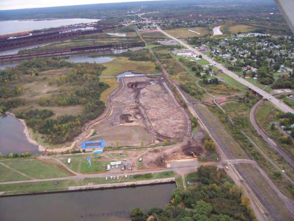
3 Site Location

4 Murphy Oil s Impoundment

5
6 Newton Creek Creek is approximately 3 wide and 6 deep at normal flow levels Floodplain is heavily vegetated with wetland plants and trees Creek typically flows at 1 cfs into Hog Island Inlet. Segment L - affected by seiche currents

7

8

9
10 Hog Island Inlet Approximately 17 acres. Connected to Lake Superior Bay via a narrow channel. Water depth ranges from 1 to 7 feet. Sediment in both NC and HI Inlet are fine grained materials (silt and clay). Affected by seiche currents

11

12
13 Project History Early 1990 s studies found elevated levels of PAHs, diesel range organics, oil, grease, and heavy metals 1995 Murphy Oil constructs new Wastewater Treatment Plant Memorandum of Understanding Murphy Oil removes contaminated sediment from their impoundment and Segment A of Newton Creek Department removes 7,400 tons of contaminated sediment and soil from Segments B-K, of Newton Creek Murphy Oil constructs wetland treatment system 2004 Application for Great Lakes Legacy Act Funding
14 Hog Island Inlet Newton Creek Studies since 1992 Identification of Pollutants of Concern, Further Needed Site Assessments, and Estimated Remediation Costs for Contaminated Sediments in Newton Creek, Hog Island Inlet, and Potentially, Superior Harbor, WDNR, April 6, 1992; Newton Creek/Hog Island Inlet Investigative Survey, Eder Associates Consulting Engineers (for Murphy), November 1993; Evaluation of Sediment Contamination at Newton Creek and Hog Island Inlet, ENSR Consulting Engineers (for Murphy), December 1993; Human Health Risk Assessment for Newton Creek and Hog Island Inlet, ENSR (for Murphy), August 1994; Assessment of Wetland Habitats Associated with the Newton Creek System, Don Reed (for WDNR), November 23, 1994; Characterization of Sediment Contamination in the Newton Creek System, WDNR, December 15, 1994; DRAFT RCRA 3008(h) Consent Order to Murphy Oil USA, Inc., Superior, Wisconsin Facility. USEPA ID No. WID USEPA, March 01, 1995 Summary of Investigation Activities - WDNR Newton Creek Feasibility Study Supplementary Site Characterization, Burns & McDonnell (for Murphy) 1995; Remedial Alternatives Array Document for Newton Creek System, RMT (for WDNR), April 1995; Feasibility Study Report for Newton Creek System, RMT (for WDNR), October 1995; Newton Creek System Sediment Contamination Site Characterization Report, WDNR, December 1, 1995; Results of Aerobic Biodegradation Screening Treatability Study for the Newton Creek System, RMT (for WDNR), January 1996; Superior Refinery Pond Closure Project Final Workplan for Newton Creek Segment A Remediation, Roy F. Weston (for Murphy), August 1997; Site Investigation Report - Newton Creek Segments B and C, SEH (for WDNR), September 2000; Preliminary Engineering Report Newton Creek Remediation, SEH (for WDNR), November 2001; Site Investigation Work Plan Newton Creek and Hog Island Inlet, SEH (for WDNR), August 2002; Remedial Investigation Report Newton Creek Segments B-K SEH (for WDNR), February 2003; Remedial Action Options Report Newton Creek, SEH (for WDNR), April 2003; Remedial Design Report and Plans Newton Creek, SEH (for WDNR), April 2003; Site Investigation Report Hog Island Inlet, SEH (for WDNR) September 2003; and Remedial Action Options Report Hog Island Inlet SEH (for WDNR) November 2003
15 Key Studies WDNR Newton Creek System Site Characterization Report indicated: Elevated levels of contaminants exist in Newton Creek and Hog Island Inlet Toxicity to exposed laboratory organisms Ecological impacts severe in several segments of Newton Creek and Hog Island Inlet SEH confirmed findings
16 Toxicity Studies Found To aquatic organisms To tree swallows Human Health Human exposures to chemical contaminants found in soils, sediments and surface water Exposure scenarios include swimming, recreational wading and fish ingestion Risks exceed regulatory guidelines due to exposure to surface water with suspended sediment concentrations
 6.8 to 600 mg/kg Lead 7.")
17 Newton Creek/Hog Island Inlet Sediment and Soil Contamination Polynuclear aromatic hydrocarbons (PAHs) TPAHs List of 18 nd to 11,280 ug/kg Expanded list 11,354 to 100,000 ug/kg Diesel range organics (DRO) 6.8 to 600 mg/kg Lead 7.8 to 86 mg/kg

18
19 Project Goals To use community based partnerships to: Remediate the Newton Creek and Hog Island Inlet system Protect human health and the environment, Provide for healthy and safe recreational area(s), Provide quality productive aquatic habitat in Hog Island Inlet.
20 Systematic Approach Investigate degree and extent of contamination Address upstream sources first Take appropriate interim actions Turn dirt
21 Partnerships EPA/GLNPO Funding Research St Louis River CAC Local Governments City of Superior Douglas County Property Owners Murphy Oil, BNSF, Enbridge Cross Program Permits, funding, fish rescue, research Citizens

22

23

24

25

26
27 Indications of Success at Segments B-K Newton Creek Taxa Richness Pre-remediation 7.8 (October 2002) Post-remediation 14.8 (October 2003) Oligochaetes no longer dominant First caddis fly larvae collected Sunfish YOY observed Analysis of sediment traps are clean
28 2005 Activities Cleanup Segment L of Newton Creek approximately 900 feet Remove approximately 40,000 cubic yards of contaminated sediments from Hog Island Inlet Funding through the Great Lakes Legacy Act, GLNPO provided 65% funding and EPA provided contract oversight to project. Earth Tech began work in early July Last sediments removed from the Inlet on November 6th

29

30

31

32

33

34
35 Cleanup Goal 2.6 mg/kg TPAH EPA set a goal of 4.5 mg/kg Protective for chronic toxicity to benthic invertebrates Evaluated impacts of UV in setting goal
36 Remedial Plan Sediment removal Divert Newton Creek Excavate sediments to design depth Stabilize slopes Confirmatory sampling

37

38 HOG ISLAND INLET CONFINEMENT WILL EMPLOY BOTH SHEET PILING AND AQUA BARRIERS SHEET PILING WILL PROVIDE ROBUST PROTECTION FROM EMBAYMENT AQUA BARRIERS WILL PROVIDE READILY REMOVABLE COFFERDAM- LIKE FEATURES TEMPORARY BARRIER NEEDED AT MOUTH OF NEWTON CREEK TO SUPPORT EXCAVATION OF SEDIMENTS IN THE DRY SHEET PILING 6 DIAMETER AQUA BARRIER

39 NEWTON CREEK WILL BE DIVERTED OVER THE SOUTHERN AQUA BARRIER DIVERSION PIPE, STARTING ABOVE THE CULVERT, WILL BE LOCATED ALONG NEWTON CREEK, UNDER THE RAILROAD TRESTLE LIMITED WATER NEAR BASE OF NEWTON CREEK WILL BE PUMPED DIRECTLY INTO CONFINED HOG ISLAND INLET

40 HOG ISLAND INLET WATER WILL BE PUMPED TO POTW STORMWATER RETENTION BASIN MAXIMUM FLOW RATE OF 1,000 GPM PROBABLY 750 GPM AVAILABLE ROUTE GOES UNDER TRESTLE AND FOOTBRIDGE DEWATERING WILL REQUIRE ABOUT 15 DAYS CONCURRENT WITH NEWTON CREEK EFFORT
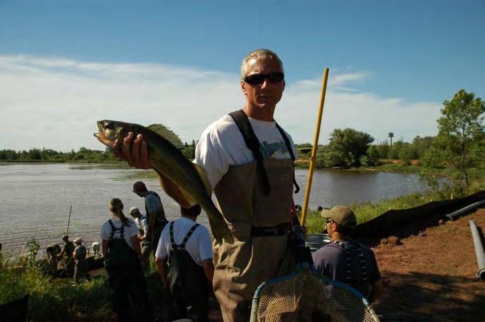
41

42

43

44

45

46

47

48
49 Fish Rescue 1,800 fish rescued Black crappie, channel catfish, common shiner, log perch, muskellunge, northern pike, white and yellow perch, rock bass, redhorse, trout perch, walleye 138 freshwater clams 38 painted turtles

50
51

52

53

54
55

56

57

58

59

60

61

62

63

64
65 Hog Island Results 60,175 tons of contaminated sediments removed Beneficial reuse of 50% of material incorporated into landfill cap rooting zone and/or grading layer Decision based on 50 mg/kg lead Cleanup goal of 2.6 mg/kg met

66
67 Source Control Role of other Parties Murphy Oil Wastewater Facility Improvements Cleanup of Impoundment and Segment A Constructed Wetlands Funding Access Burlington Northern City of Superior Douglas County Enbridge Disposal and Treatment Future Use
68 Funding Sources Department of Natural Resources - Environmental Fund EPA GLNPO Department of Administration - Coastal Management Section EPA GLNPO - Wisconsin Share EPA GLNPO - Great Lakes Legacy Act Murphy Oil
69 Newton Creek/Hog Island Inlet The second Great Lakes Legacy Act Project completed first On time Under budget Great project team Focus on the future
70 What s Next Local Committee studying future use Biohabitats Hog Island and Newton Creek Ecological Restoration Master Plan Sediment Assessment Study Wisconsin Waters of the St. Louis River


71 What Should Hog Island Inlet Be Now That It Is Clean Sheltered Bay Habitat: forage fish habitat: emerald and spottail shiners feeding area for common terns and other waterbirds- near common tern nesting habitat


72 Waterfowl and other bird habitat Fringing wetlands Variety of aquatic vegetation Community resource
Cat Island Chain Restoration, Green Bay
 Cat Island Chain Restoration, Green Bay Victoria Harris, UW Sea Grant January 27, 2005 Southern Green Bay historically provided diverse coastal wetland habitats for fish and wildlife Expansive emergent
U. S. Steel Duluth Works - Spirit Lake Cleanup Plan FAQs
 St. Louis River Area of Concern U. S. Steel Duluth Works - Spirit Lake Cleanup Plan FAQs Spirit Lake is a large, open area in the St. Louis River that has cultural, historical, and recreational significance
US Steel/Spirit Lake Sediment Cleanup Update for River Corridor Coalition
 US Steel/Spirit Lake Sediment Cleanup Update for River Corridor Coalition Erin Endsley, Project Manager Mike Bares, Technical Analyst Minnesota Pollution Control Agency August 26, 2015 Outline Site history
Great Lakes Legacy Act: Program Overview and Status of Lake Superior Projects
 Great Lakes Legacy Act: Program Overview and Status of Lake Superior Projects D. Scott Ireland Marc Tuchman U.S. EPA-GLNPO Making a Great Lake Superior October 30, 2007 Volume - cubic yards Cumulative
Great Lakes Legacy Act. Marc Tuchman U.S. EPA Great Lakes National Program Office
 Great Lakes Legacy Act Marc Tuchman U.S. EPA Great Lakes National Program Office 1,000,000 Cumulative Sediment Remediated In U.S. Great Lakes Lakes Volume- cubi c yards 5,000,000 4,000,000 3,000,000 2,000,000
Great Lakes Legacy Act. Marc Tuchman U.S. EPA Great Lakes National Program Office
 Great Lakes Legacy Act Marc Tuchman U.S. EPA Great Lakes National Program Office Great Lakes Legacy Act a a new tool in the Great Lakes sediment remediation toolbox Goal: Accelerate the pace of sediment
New York- New Jersey Harbor Estuary. Lower Passaic River
 Lower 8 Miles of the Lower Passaic River Focused Feasibility Study November 7, 2013 New York- New Jersey Harbor Estuary Lower Passaic River 2 Diamond Alkali Superfund Site: Contaminated with dioxins, PCBs,
Great Lakes Coastal Wetland Monitoring: Support of Restoration Across the Basin
 : Support of Restoration Across the Basin Matthew J. Cooper University of Notre Dame, Notre Dame, IN Presentation Outline Quality control and assurance Importance of basin wide monitoring Examples of our
Buffalo River, New York Great Lakes Restoration Initiative (GLRI) Dredging
 Dredging") Buffalo River, New York Great Lakes Restoration Initiative (GLRI) Dredging Partners: U.S. EPA New York State DEC Buffalo Niagara Riverkeeper U.S. Army Corps of Engineers Presented by: Scott Cieniawski
Buffalo River, New York Great Lakes Restoration Initiative (GLRI) Dredging Partners: U.S. EPA New York State DEC Buffalo Niagara Riverkeeper U.S. Army Corps of Engineers Presented by: Scott Cieniawski
Buffalo River Area of Concern Cleanup Public Meeting
 Buffalo River Area of Concern Cleanup Public Meeting September 23, 2013 6:00 PM 8:00 PM Old First Ward Community Center 6:15 PM Opening Remarks Jill Jedlicka, Buffalo Niagara RIVERKEEPER John Morris, Honeywell
Grand Calumet. River Revitalized
 The Grand Calumet River Revitalized Imagine a Grand Calumet River safe for people, fish, birds and wildlife to utilize and enjoy. With the latest clean up efforts, performed under the Great Lakes Restoration
Lake Bemidji South Shore Restoration and Enhancement
 Lake Bemidji South Shore Restoration and Enhancement Craig Gray, PE Director of Public Works & City Engineer Sherry Van Duyn, PE, CHMM Senior Civil Engineer 1 Project Location 2 Former Lake Uses Logging
Pierce County Islands and the Head of Lake Pepin
 Pierce County Islands and the Head of Lake Pepin CAP Section 204 - Beneficial Use of Dredged Material Public Meeting and Open House St. James Hotel April 4, 2018 US Army Corps of Engineers 1 What this
The Ottawa River Great Lakes Legacy Act Cleanup Project. March 12, 2009
 The Ottawa River Great Lakes Legacy Act Cleanup Project March 12, 2009 Ottawa River Project Timeline January 1998 to December 2007 Various entities sample the site, source control implemented (including
Industry Perspective on the Great Lakes Legacy Act Sediment Remediation Program
 Industry Perspective on the Great Lakes Legacy Act Sediment Remediation Program Steven C. Nadeau Ryerson Creek GLNPO GLLA Meeting Muskegon, Michigan January 23, 2014 Great Lakes Legacy Act Overview of
Lessons Learned, Innovations, and Successes from U.S. Great Lakes Areas of Concern Sediment Cleanups
 Lessons Learned, Innovations, and Successes from U.S. Great Lakes Areas of Concern Sediment Cleanups Presented at RPIC Federal Contaminated Sites National Workshop April 15, 2014 Gina Bayer, CH2M HILL
PROPOSED PLAN FOR CLEANING UP THE LOWER 8 MILES OF THE LOWER PASSAIC RIVER
 PROPOSED PLAN FOR CLEANING UP THE LOWER 8 MILES OF THE LOWER PASSAIC RIVER June 23, 2014 Belleville, New Jersey 6/16/2014 New York- New Jersey Harbor Estuary Lower Passaic River Diamond Alkali Superfund
APPLICATION FOR 2013 WEDA ENVIRONMENTAL EXCELLENCE AWARD ENVIRONMENTAL DREDGING CATEGORY RIVER RAISIN AREA OF CONCERN PROJECT, MONROE, MICHIGAN
 APPLICATION FOR 2013 WEDA ENVIRONMENTAL EXCELLENCE AWARD ENVIRONMENTAL DREDGING CATEGORY RIVER RAISIN AREA OF CONCERN PROJECT, MONROE, MICHIGAN SUMMARY The construction team of Environmental Restoration,
Lower River and Inner Harbor of the Sheboygan River
 Final Focused Feasibility Study Report Lower River and Inner Harbor of the Sheboygan River Sheboygan River Area of Concern Sheboygan, Wisconsin WA No. 123-RICO-1507 / Contract No. EP-S5-06-01 Prepared
San Jacinto River Waste Pits Superfund Site Technical Document Review: Remedial Alternatives Memorandum (RAM)
") San Jacinto River Waste Pits Superfund Site Technical Document Review: Remedial Alternatives Memorandum (RAM) By Jennifer Ronk and Cheyenne Morgan, Houston Advanced Research Center What is the purpose
San Jacinto River Waste Pits Superfund Site Technical Document Review: Remedial Alternatives Memorandum (RAM) By Jennifer Ronk and Cheyenne Morgan, Houston Advanced Research Center What is the purpose
Prioritizing Habitat Projects in Areas of Concern Throughout the Great Lakes
 Prioritizing Habitat Projects in Areas of Concern Throughout the Great Lakes Karen Rodriguez U.S. Environmental Protection Agency Great Lakes National Program Office August 1, 2013 Great Lakes Water Quality
Indiana Harbor and Canal (IHC) Confined Disposal Facility (CDF) and Navigational Dredging
 Confined Disposal Facility (CDF) and Navigational Dredging") Indiana Harbor and Canal (IHC) Confined Disposal Facility (CDF) and Navigational Dredging Purdue Water Institute 05 November 2013. US Army Corps of Engineers Topics for Today Brief Introduction to USACE
Indiana Harbor and Canal (IHC) Confined Disposal Facility (CDF) and Navigational Dredging Purdue Water Institute 05 November 2013. US Army Corps of Engineers Topics for Today Brief Introduction to USACE
COON CREEK WATERSHED DISTRICT PERMIT REVIEW
 16-054 Woodland Creek Wetland Banking Restoration Project, Page 1 of 6 COON CREEK WATERSHED DISTRICT PERMIT REVIEW MEETING DATE: August 22, 2016 AGENDA NUMBER: 11 FILE NUMBER: 16-054 ITEM: Woodland Creek
GRADING, EROSION AND SEDIMENTATION CONTROL
 SECTION 500 GRADING, EROSION AND SEDIMENTATION CONTROL 501 Erosion and Sedimentation Control Plan All engineering plans for projects that propose to construct new, or modify existing drainage facilities,
Enbridge Line 6B Incident Public Update and Availability Session
 Enbridge Line 6B Incident Public Update and Availability Session October 14, 2010 (Day 81) Division A Oil coming out of culvert on Talmadge Creek on first day of spill, July 26, 2010. Exposed pipeline
Fill Material and Soil Management
 Fill Material and Soil Management What You Need to Know The purpose of this fact sheet is to describe how fill material and excess soil can be reused properly during the cleanup and redevelopment of properties
East Branch of Grand Calumet River, Reaches 4A/4B. WEDA WODCON XXI June 13-17, 2016 The Hyatt Regency, Miami, FL
 East Branch of Grand Calumet River, Reaches 4A/4B WEDA WODCON XXI June 13-17, 2016 The Hyatt Regency, Miami, FL Project Representatives Agencies and Stakeholders USEPA Great Lakes National Program Office
Duwamish Waterway Self Guided Tour: Turning Basin Number Three and Terminal 105 Aquatic Habitat Restoration Sites
 Duwamish Waterway Self Guided Tour: Turning Basin Number Three and Terminal 105 Aquatic Habitat Restoration Sites Text and illustrations in the following pages include: (1) summary information describing
Detroit River. Area of Concern Canadian Section. Status of Beneficial Use Impairments September 2010
 The Detroit River is a major navigation corridor of the Great Lakes, extending 51 km from Lake St. Clair to Lake Erie. Its watershed, which covers about 2000 km 2 (200 000 ha) on both sides of the international
Norwalk Harbor Report Card
 Norwalk Harbor Report Card C+ Following the water s trail from your house, into the river, and to the Harbor The way land is used in a watershed has a significant effect on water quality. In areas where
Great Lakes Biodiversity Conservation Strategies
 A.D. Latornell Conservation Symposium Dan Kraus, Nature Conservancy of Canada 21 November 2013 Summary Two Minute History of Application and Next Steps 2 Two Minute History of the Part 1: Paradise Found
Restore America s Estuaries October 24, 2012
 Coordinating Dredged Material Management in the Pacific Coast s Largest Estuary with Construction of the Pacific Coast s Largest Tidal Wetland Restoration Project. Restore America s Estuaries October 24,
ALLIANT ENERGY WISCONSIN POWER AND LIGHT COLUMBIA ENERGY CENTER CCR SURFACE IMPOUNDMENT ANNUAL INSPECTION REPORT. January 15, 2016
 ALLIANT ENERGY WISCONSIN POWER AND LIGHT COLUMBIA ENERGY CENTER CCR SURFACE IMPOUNDMENT ANNUAL INSPECTION REPORT January 15, 2016 EXECUTIVE SUMMARY This annual inspection report has been prepared in accordance
KRISTOPHER J. KRZYSTON, CEI, CEM
 PERMITTING IN NEW JERSEY KRISTOPHER J. KRZYSTON, CEI, CEM Kristopher J. Krzyston Rutgers graduate 1994 B.S. Environmental Planning Certificate in G.I.S. Assistant Division Manager Environmental Science
4. FISH PASSAGE CONCEPTS
 Feasibility Study for Restoration of Titlow Lagoon Fish Passage South Puget Sound Salmon Enhancement Group 4. FISH PASSAGE CONCEPTS Fish passage could be improved by rehabilitating the existing fish passage,
St. Louis River Area of Concern A Great Lakes Restoration Initiative - MN Legacy Fund Partnership
 St. Louis River Area of Concern A Great Lakes Restoration Initiative - MN Legacy Fund Partnership Interstate Regulatory Technology Council Annual Meeting Bloomington, MN April 20, 2016 Nelson T. French
Hamilton Harbour. Area of Concern Status of Beneficial Use Impairments September 2010
 Hamilton Harbour Area of Concern Status of Beneficial Use Impairments September 2010 Hamilton Harbour is a 2150-ha bay located at the western tip of Lake Ontario. The Area of Concern covers about 500 km
COORDINATING A MULTI-YEAR, MULTI-MILLION DOLLAR WATERSHED-WIDE FISH PASSAGE PROGRAM
 COORDINATING A MULTI-YEAR, MULTI-MILLION DOLLAR WATERSHED-WIDE FISH PASSAGE PROGRAM A Case Study of Major Dam Natural Fishways & Removal Coordinating Resources for Measurable Outcomes Andrew T. Struck,
Enbridge Oil Spill. Kalamazoo. Marshall. Augusta Battle Creek. Galesburg Ceresco. Release Site. Morrow Lake
 Enbridge Oil Spill Augusta Galesburg Morrow Lake Release Site Area August 4, 2010 Area Area August 5, 4, 2010 Area August September 5, 20, 2010 2012 Area September 20, 2012 September 17, 2014 Talmadge
BAYFRONT CANAL AND ATHERTON CHANNEL PROJECT DESCRIPTION
 APPENDIX I BAYFRONT CANAL AND ATHERTON CHANNEL PROJECT DESCRIPTION South Bay Salt Pond Restoration Project Phase 2 July 2015 Draft Environmental Impact Statement/Report 2185 N. California Blvd., Suite
Less than 8 feet finished water depth. 4-Foot Cap 3-Foot Cap Foot Cap. 4 Ft
 Herbivorous Animals Consuming Plants & Sediment Piscivorous Wildlife Consuming Fish Insectivorous Wildlife Consuming Emerging Aquatic Invertebrates Burrowing Organisms Contacting Contaminated Sediment
Contaminated sediment management in the U.S.
 Contaminated sediment management in the U.S. Rebecca Gardner Anchor QEA, USA and Norway company logo comes here Contents Brief overview of beneficial use activities in the United States (U.S.) Relating
Valentine-Clark State Superfund Site Bridal Veil Pond Open Space Operable Unit City of Minneapolis, Hennepin County, Minnesota
 October 12, 2007 SITE DESCRIPTION FINAL MINNESOTA DECISION DOCUMENT Valentine-Clark State Superfund Site Bridal Veil Pond Open Space Operable Unit City of Minneapolis, Hennepin County, Minnesota The Bridal
Tampa Port Authority
 McKay Bay Restoration (McKay Bay Mitigation Site and McKay Bay Dredge Hole Restoration) Tampa Port Authority 2014 AAPA Environmental Awards Competition June 2014 Contact: Andy Fobes, Director of Public
A One Water Approach to Restoring Sheboygan River and its Legacy
 A One Water Approach to Restoring Sheboygan River and its Legacy Gina Bayer CH2M Stacy Hron WI Dept. of Natural Resources What is an AOC? Why is the river an AOC? Why is the river an AOC? Why is the river
BUI 2 Blueprint: Degraded Fish and Wildlife Populations
 D29 BUI2Blueprint: ThissectioncontainstheBUIBlueprintforDegradedFishandWildlifePopulations.Theblueprintis organizedintothemajorcomponentsofeachbuiblueprintasdescribedintheintroductiontothis appendix.thebuiteammembersandtheiraffiliationsarelistedbelow,followedbyasummary
HISTORY OF CONSTRUCTION FOR EXISTING CCR SURFACE IMPOUNDMENT PLANT MCMANUS ASH POND A (AP-1) 40 CFR (c)(1)(i)-(xii)
 40 CFR (c)(1)(i)-(xii)") HISTORY OF CONSTRUCTION FOR EXISTING CCR SURFACE IMPOUNDMENT PLANT MCMANUS ASH POND A (AP-1) 40 CFR 257.73(c)(1)(i)-(xii) (i) Site Name and Ownership Information: Site Name: Site Location: Site Address:
HISTORY OF CONSTRUCTION FOR EXISTING CCR SURFACE IMPOUNDMENT PLANT MCMANUS ASH POND A (AP-1) 40 CFR 257.73(c)(1)(i)-(xii) (i) Site Name and Ownership Information: Site Name: Site Location: Site Address:
PROJECT OVERVIEW. Site Assessment for Proposed Coke Point Dredged Material Containment Facility at Sparrows Point
 PROJECT OVERVIEW Site Assessment for Proposed Coke Point Dredged Material Containment Facility at Sparrows Point Capacity of existing placement sites for dredged material from the Baltimore Harbor remains
Model Riparian Buffer Ordinance.
 Model Riparian Buffer Ordinance. This is a sample riparian buffer ordinance written as an amendment to an existing zoning ordinance. This ordinance complies with the state minimum standards for river corridor
Wisconsin Point Area Management Plan. August, 2011
 Wisconsin Point Area Management Plan August, 2011 The Resource Project Area 2,300 Acres 10.4 Total miles of shoreline 4.3 Miles of sand beach Longest freshwater sand spit in the world Ownership Douglas
Addendum to Feasibility Study
 Addendum to Feasibility Study Former Duluth Works and Spirit Lake Sediment Site Prepared for Great Lakes Legacy Act Partnership between United States Steel Corporation, United States, Environmental Protection
City of Fairmont Storm Water Pollution Prevention Plan (SWPPP) January 23, 2017
 January 23, 2017") City of Fairmont Storm Water Pollution Prevention Plan (SWPPP) January 23, 2017 Why is Water Quality Important? Water has always been important to Minnesota and is a key part of our history, culture, economy
City of Fairmont Storm Water Pollution Prevention Plan (SWPPP) January 23, 2017 Why is Water Quality Important? Water has always been important to Minnesota and is a key part of our history, culture, economy
CLEARWATER TOWNSHIP WATER QUALITY ACTION PLAN
 CLEARWATER TOWNSHIP WATER QUALITY ACTION PLAN Elk-River-Chain-of-Lakes Gaps Analysis Project The Watershed Center Grand Traverse Bay Michigan Department of Environmental Quality July 2011 Purpose The Grand
BIG ROCHE A CRI LAKE CHARACTERISTICS
 BIG ROCHE A CRI LAKE CHARACTERISTICS Lake Description Big Roche Cri Lake is located in north central Adams County and has a surface area of 205 acres, a shoreline length of 6.1 mile, a volume of 6,993
CASE STUDY 5. Economic Benefits of Remediating Contaminated Sediments at Hamilton Harbour s Randle Reef
 CASE STUDY 5 Economic Benefits of Remediating Contaminated Sediments at Hamilton Harbour s Randle Reef Economic Benefits of Remediating Contaminated Sediments at Hamilton Harbour s Randle Reef By Kristin
OUR MISSION: To preserve, protect, and restore Delaware s Inland Bays the water that flows into them and the watershed around them.
 OUR MISSION: To preserve, protect, and restore Delaware s Inland Bays the water that flows into them and the watershed around them. OUR In 1988, the Delaware Inland Bays were declared an estuary of national
Monroe County Canal Restoration Updates Prepared by Wendy Blondin, AMEC
 Monroe County Canal Restoration Updates 7-10-13 Prepared by Wendy Blondin, AMEC Phase 1 Canal Management Master Plan (CMMP) Monroe County in association with AMEC was awarded a grant from DEP in March
ROCHESTER EMBAYMENT AREA OF CONCERN
 ROCHESTER EMBAYMENT AREA OF CONCERN Restrictions on Dredging Activities Beneficial Use Impairment Removal Report FEBRUARY 2018 (DRAFT) Rochester Embayment Area Of Concern Restrictions on Dredging Activities
Summary of Investigations & Remedial Activities
 Summary of Investigations & Remedial Activities Former Farmland Industries Nitrogen Manufacturing Plant Lawrence, Kansas November 9, 2009 Topics of Discussion Previous Investigations/Remedial Actions (Pre-2000s)
Engineering with Nature In Action: SLR AOC Living Shoreline Design Basis
 Engineering with Nature In Action: SLR AOC Living Shoreline Design Basis Joseph P. Kreitinger, PhD US Army Engineer Research and Development Center Ithaca, NY Adam C. Wagner, PE USACE LRE Detroit, MI Dan
Red Rock Lake: A Path Forward
 University of Minnesota Morris Digital Well University of Minnesota Morris Digital Well Center for Small Towns 6-2016 Red Rock Lake: A Path Forward Colette Millard Student - University of Minnesota, Morris
FOCUSED FEASIBILITY STUDY FOR PASSAIC RIVER SEDIMENTS: IDENTIFYING OPPORTUNITIES FOR EARLY ACTION
 FOCUSED FEASIBILITY STUDY FOR PASSAIC RIVER SEDIMENTS: IDENTIFYING OPPORTUNITIES FOR EARLY ACTION Liam Bossi 1, Scott E. Thompson, PE 2, R. Bruce Fidler, PE 3, Daria Navon, PE 4, and Thalia Loor 5 ABSTRACT
Memorandum BACKGROUND AND PURPOSE
 COTTONWOOD WETLANDS Memorandum William P. Ruzzo, PE, LLC 6641 West Hamilton Drive, Lakewood, Colorado 80227 (303) 985-1091 (303) 989-6561 fax bill.ruzzo@comcast.net To: Chuck Reid, Manager, CCBWQA Cc:
Weldcraft Boatyard Clean-up and Redevelopment Project
 Weldcraft Boatyard Clean-up and Redevelopment Project Habitat Mitigation Mike Stoner Environmental Director Port of Bellingham 1801 Roeder Avenue Bellingham, WA 98227 mikes@portofbellingham.com June 10,
COON CREEK WATERSHED DISTRICT PERMIT REVIEW. KTJ 314, LLC Blaine, MN 55449
 18-118 ABRA Auto Body, Page 1 of 8 COON CREEK WATERSHED DISTRICT PERMIT REVIEW MEETING DATE: August 13, 2018 AGENDA NUMBER: 14 FILE NUMBER: 18-118 ITEM: ABRA Auto Body RECOMMENDATION: Approve with 6 Stipulations
Creative Financing: Implementing the St. Louis River Area of Concern Remedial Action Plan in MN
 Creative Financing: Implementing the St. Louis River Area of Concern Remedial Action Plan in MN Great Lakes Dredging Team 2017 Annual Meeting Pier B Resort Dan Breneman/Nelson French May 22, 2017 A Great
Northwest Oil Drain Canal: Sediment Remediation Using Bypass and Excavation TEAL DREHER, ROB WEBB, PAUL FUGLEVAND DALTON, OLMSTED & FUGLEVAND, INC.
 1 Northwest Oil Drain Canal: Sediment Remediation Using Bypass and Excavation TEAL DREHER, ROB WEBB, PAUL FUGLEVAND DALTON, OLMSTED & FUGLEVAND, INC. Overview 2 The recently completed Northwest Oil Drain
Salt Marsh Restoration
 Salt Marsh Restoration through the Beneficial Re-Use of Dredged Material JACQUELINE JAHN PROJECT ECOLOGIST, GREENVEST, LLC Project Background Objective: Three trial projects to test the marsh restoration
Annapolis Lead Mine Site Iron County, Missouri
 CASE STUDY Annapolis Lead Mine Site Iron County, Missouri August 2010 Prepared by The Interstate Technology & Regulatory Council Mining Waste Team Permission is granted to refer to or quote from this publication
Sustain Our Great Lakes 2018 Grant Slate
 Sustain Our Great Lakes 2018 Grant Slate NFWF CONTACTS Aislinn Gauchay Program Director, Great Lakes aislinn.gauchay@nfwf.org 612-564-7284 Traci Giefer Program Manager, Great Lakes traci.giefer@nfwf.org
Habitat Grant Projects Clinton River Watershed
 Habitat Grant Projects Clinton River Watershed L Y N N E S E Y M O U R E N V I R O N M E N T A L E N G I N E E R O F F I C E O F T H E M A C O M B C O U N T Y P U B L I C W O R K S C O M M I S S I O N
Chapter 6 Erosion & Stormwater Study Team
 Chapter 6 Erosion & Stormwater Study Team Objective How do we stabilize the Las Vegas Wash environment to most effectively reduce erosion and enhance wetlands? Introduction The Las Vegas Wash (Wash) has
Restoring The Elizabeth River From The Bottom Up
 Restoring The Elizabeth River From The Bottom Up Presented by: Joe Rieger Elizabeth River Project Co-author: Walter Priest, NOAA Restoration Center www.elizabethriver.org The Elizabeth River Project Mission:
EVALUATION OF ENVIRONMENTAL MONITORING DATA GATHERED DURING ASHTABULA RIVER DREDGING, ASHTABULA RIVER, OHIO
 EVALUATION OF ENVIRONMENTAL MONITORING DATA GATHERED DURING ASHTABULA RIVER DREDGING, ASHTABULA RIVER, OHIO D. Plomb 1, S. Cieniawski 2, and D. Pham 3 ABSTRACT The Ashtabula River Area of Concern (AOC)
MINNESOTA DECISION DOCUMENT
 MINNESOTA DECISION DOCUMENT 3M Cottage Grove Disposal Site City of Cottage Grove, Washington County, Minnesota SITE DESCRIPTION Background The 3M Cottage Grove Site (Site) encompasses a large industrial
PORT MASTER PLAN AMENDMENT NO. 26 LA WATERFRONT LAND USE ADDITIONS, MINOR FILLS, AND NEW HARBORS
 PORT MASTER PLAN AMENDMENT NO. 26 LA WATERFRONT LAND USE ADDITIONS, MINOR FILLS, AND NEW HARBORS BACKGROUND The Port Master Plan for the Port of Los Angeles (Port) was certified by the California Coastal
Hydrologic and Ecologic Impacts from the CERP Indian River Lagoon South Project
 Hydrologic and Ecologic Impacts from the CERP Indian River Lagoon South Project Dr. Gretchen Ehlinger Senior Biologist US Army Corps of Engineers Jacksonville District November 15, 2016 AWRA Conference
Jason R. Vogel, Ph.D., P.E. Biosystems and Agricultural Engineering Oklahoma State University
 Stormwater 101 OKLAHOMA STATE UNIVERSITY Biosystems and Agricultural Engineering Department Jason R. Vogel, Ph.D., P.E. Biosystems and Agricultural Engineering Oklahoma State University Stormwater is excess
Environmental Information Worksheet
 Environmental Information Worksheet Water System Owner (Attach additional sheets if necessary) Needs and Alternatives Provide a brief narrative that describes: Current drinking water system needs. Project
2.BACKGROUND SITE INFORMATION
 2.BACKGROUND SITE INFORMATION A. Site History The site is located in the south-central portion of Scott County and more specifically in Oneida, Tennessee. In the early 1950s, a cross-tie treatment facility
Municipal Stormwater Management Plan Prepared For The Borough of Cape May Point By Van Note-Harvey Associates VNH File No.
 Municipal Stormwater Management Plan Prepared For The Borough of Cape May Point By Van Note-Harvey Associates 2005 VNH File No. 35317-210-21 Table of Contents Introduction... 3 Goals... 3 Storm water Discussion...
PROJECT SCOPE OF WORK CITY OF TOWN AND COUNTRY STORMWATER PROGRAM
 PROJECT SCOPE OF WORK CITY OF TOWN AND COUNTRY STORMWATER PROGRAM Project Name: Essex Point Subdivision/Sellenriek Retention Project ID Number: 2-A Problem: The watershed above the Essex Point Subdivision
City of Fairmont Storm Water Pollution Prevention Plan Annual Public Meeting. June 11, 2018
 City of Fairmont Storm Water Pollution Prevention Plan Annual Public Meeting June 11, 2018 Why is Water Quality Important? Water has always been important to Minnesota and is a key part of our history,
Facts About. LMA Fill Material and Soil Management Guidance. Introduction. What Soils and Fill Material are Subject to the Policy?
 Facts About LMA Fill Material and Soil Management Guidance The purpose of this guidance is to describe how fill material and excess soil can be reused properly during the cleanup and redevelopment of properties
Kingston Steam Plant-Ash Spill Kingston Fossil Plant Fly Ash Spill
 Kingston Steam Plant-Ash Spill Kingston Fossil Plant Fly Ash Spill Location and Plant History Located on Watts Bar Reservoir (Emory River), 3 miles upstream of confluence of Clinch River and Tennessee
Osher Course. What Lies Beneath the Inland Bays?
 Osher Course What Lies Beneath the Inland Bays? Objectives for Course Describe the Delaware Inland Bays and their tributaries Illustrate the ecology and importance of estuaries Demonstrate the threats
ENVIRONMENTAL IMPACT STATEMENT CLEVELAND HARBOR, CUYAHOGA COUNTY, OHIO DREDGED MATERIAL MANAGEMENT PLAN PUBLIC SCOPING INFORMATION PACKET
 ENVIRONMENTAL IMPACT STATEMENT CLEVELAND HARBOR, CUYAHOGA COUNTY, OHIO DREDGED MATERIAL MANAGEMENT PLAN PUBLIC SCOPING INFORMATION PACKET March 16, 2006 ANNOUNCEMENT OF PUBLIC SCOPING MEETINGS The U.S.
Information for File # ARC
 Information for File # 2015-02993-ARC Applicant Corps Contact St. Louis-Lake Counties Regional Rail Authority Andrew R. Chambers Address 600 South Lake Avenue, Suite 211, Duluth, MN 55802 E-Mail Andrew.R.Chambers@usace.army.mil
Bluff Creek One Water
 Bluff Creek One Water The Bluff Creek Watershed has no lakes within its boundaries. As the westernmost watershed within the District, land use changes from agricultural to residential have occurred relatively
DC STORMWATER PLAN CONSOLIDATED TOTAL MAXIMUM DAILY LOAD (TDML) IMPLEMENTATION PLAN
 IMPLEMENTATION PLAN") DC STORMWATER PLAN CONSOLIDATED TOTAL MAXIMUM DAILY LOAD (TDML) IMPLEMENTATION PLAN CONTENTS Introduction 1 The Challenge 5 The Solution 7 Tracking Progress 11 What can you do? 15 INTRODUCTION The DC Stormwater
DC STORMWATER PLAN CONSOLIDATED TOTAL MAXIMUM DAILY LOAD (TDML) IMPLEMENTATION PLAN CONTENTS Introduction 1 The Challenge 5 The Solution 7 Tracking Progress 11 What can you do? 15 INTRODUCTION The DC Stormwater
Joe Cappel Toledo-Lucas County Port Authority. Wednesday, March 14, Western Dredging Association 2018 Midwest Chapter Meeting
 Joe Cappel Toledo-Lucas County Port Authority Wednesday, March 14, 2018 1 Toledo Harbor Dredging Federal Channel spans RM 7 to LM 18 (25 miles, 400-500 ft. width) Projected 1M CY Dredged Annually, includes
Environmental Check List Georgia Environmental Policy Act
 Environmental Check List Georgia Environmental Policy Act Project No. : Project Name: GEORGIA IS AREA AFFECTED? IF AFFECTED, HOW SEVERELY? AREA/CATEGORY NO YES UNKNOWN MINOR MEDIAN MAJOR UNKNOWN 1. Wetlands
Responsible Mining in the Lake Superior Basin Dec. 2013
 Responsible Mining in the Lake Superior Basin Dec. 2013 In this document Introduction Part 1: Statement on Responsible Mining Part 2: Specific Recommendations for Mining Projects in the Lake Superior Basin.
MAXIMIZING THE ECONOMICS OF CLEAN WATER USING A HYDRAULIC DREDGE AND A MECHANICAL DEWATERING PLANT: CASE STUDY OF LAKE DELAVAN, DELAVAN WISCONSIN
 MAXIMIZING THE ECONOMICS OF CLEAN WATER USING A HYDRAULIC DREDGE AND A MECHANICAL DEWATERING PLANT: CASE STUDY OF LAKE DELAVAN, DELAVAN WISCONSIN Thomas B. Amaro and Dennis Thomas Anybody Wanna go to the
Wetlands Application. Constructed Wetlands
 Constructed Wetlands A constructed wetland system treats wastewater by filtration, settling, and bacterial decomposition in a lined marsh. Constructed wetland systems have been used nationally and internationally
CHAPTER 7. San Dieguito River Flooding Adaptation
 CHAPTER 7 San Dieguito River Flooding Adaptation This chapter includes a range of adaptation measures to address vulnerabilities from flooding along the San Dieguito River, including the river valley,
PFC Contamination Update
 PFC Contamination Update Michael Kanner Superfund Section Manager Ingrid Verhagen Hydrologist, Closed Landfill Unit Doug Wetzstein Superfund Unit Supervisor Paul Hoff Environmental Reporting Unit Supervisor
NRC fellow, USEPA-MED, Duluth, MN. USEPA-MED, Duluth, MN. ORISE participant, USEPA-MED, Duluth MN. USEPA, NERL/EERD, Cincinnati, OH
 The truth is out there: integrating DNA-based data into bioassessments improves our understanding of species distributions and species habitat relationships Christy Meredith 1, Joel Hoffman 2, Anett Trebitz
Ashtabula Harbor, Ohio Great Lakes Restoration Initiative (GLRI) Dredging
 Dredging") Ashtabula Harbor, Ohio Great Lakes Restoration Initiative (GLRI) Dredging Partners: U.S. EPA Ohio EPA Ashtabula City Port Authority U.S. Army Corps of Engineers Presented by: Scott Cieniawski U.S. EPA
Ashtabula Harbor, Ohio Great Lakes Restoration Initiative (GLRI) Dredging Partners: U.S. EPA Ohio EPA Ashtabula City Port Authority U.S. Army Corps of Engineers Presented by: Scott Cieniawski U.S. EPA
Lake Lou Yaeger Section 206 Study Aquatic Ecosystem Restoration
 Lake Lou Yaeger Section 206 Study Aquatic Ecosystem Restoration Ashley Rasnic Michelle Kniep St. Louis District U.S. Army Corps of Engineers July 2, 2015 US Army Corps of Engineers Concerns Loss of lake