Enhanced Wetland Classification Inferred Products User Guide Version 1.0 September 2011
|
|
|
- Collin Clarke
- 5 years ago
- Views:
Transcription


1 Enhanced Wetland Classification Inferred Products User Guide Version 1.0 September 2011
2 Table of Contents List of Figures and Tables... 3 Introduction... 4 Inferred Product Background... 5 Environmental determinants of wetlands... 5 Classification Schemes... 7 Environmental Determinants Inferred Products... 7 Soil Moisture Factor... 7 Description of moisture classes Inferred Soil Moisture Hydrodynamic Factor Description of Hydrodynamic Classes Inferred Hydrodynamics Nutrient Availability Factor Description of Nutrient Regime Classes Inferred Nutrient Availability Conclusion and Summary References Ducks Unlimited Canada 2
3 List of Figures and Tables Figure 1. Landscape cross-section of Boreal Plains wetlands showing the relative positions of the major wetland types and the corresponding positions of water regime, soil regime, and nutrient status (adapted to the Boreal Plains and expanded from Harris et. al. 1996)....5 Figure 2. Edatopic grid showing the distribution of wetland classes in relation to inferred moisture, nutrient, and hydrodynamic regimes....6 Table 1. Relative soil moisture code derivation guide. Adapted and expanded from Beckingham and Archibald Figure 3. General relationship between landscape position and moisture code....9 Table 2. Enhanced Wetland Classification class cross-walk to inferred soil moisture classes..15 Figure 4. An example of the soil moisture inferred product from an area near Ft. Nelson, BC. 15 Figure 5. A marsh area in the boreal with a large difference in water table elevation throughout the growing season Table 3. Inferred hydrodynamic factor classes for wetlands Table 4. Enhanced Wetland Classification class cross-walk to inferred hydrodynamic classes.20 Figure 6. An example of the hydrodynamic product from an area near Ft. Nelson, BC Table 5. Ground-level determinants of nutrient regime code (adapted and expanded from Mackenzie and Moran 2004) Table 6. General characteristics of water with different trophic status (adapted from Mackenzie and Moran, 2004) (also shown in Figure 9) Figure 7. Field photos of water bodies and the association between water color and nutrient regime Table 7. Enhanced Wetland Classification class cross-walk to inferred nutrient classes...27 Figure 8. An example of the inferred nutrient regime product from an area near Ft. Nelson, BC Ducks Unlimited Canada 3
4 Introduction In recent years, Ducks Unlimited Canada (DUC) has initiated an increasing number of research and inventory programs that highlight the importance of boreal wetlands in Canada. It is well established that these wetland ecosystems are important in that they provide numerous ecological goods and services, some of which include: wetlands filter our water; recharge our groundwater supplies; mitigate the effects of flooding and droughts; remove carbon from the atmosphere; as well as support diverse flora and fauna. In direct contrast to this vast and important global resource is the relative lack of information on Canada s boreal wetland resources, specifically wetland maps that identify the type, extent, and distribution of these systems. These maps, which help focus DUC s conservation efforts, are needed in part to determine critical waterfowl habitat, aid with impact assessments of industrial activities, provide critical inputs to scientific research and modeling efforts such as climate change, and support various international/national/provincial wetland mapping/monitoring programs (e.g. North American Waterfowl Management Plan, Canadian Wetland Inventory, Alberta s Water For Life program, etc.). Ducks Unlimited has been leading the effort to provide detailed and accurate wetland maps for large areas of the western boreal forest. This enhanced wetland classification (EWC) effort is a multi-partner collaboration with several international (US Fish & Wildlife Service, US Forest Service, and the Pew Charitable Trusts), national (Environment Canada), provincial and territorial agencies and industries (various forestry and energy companies). To date, nearly 50 million hectares of wetlands have been mapped. This inventory effort is unique in that it uses detailed field data collected in helicopters to help guide the classification of large-scale satellite images to map wetlands. Due to the complexity and diversity of wetlands in the Boreal Plains ecozone, a field guide to boreal wetlands was developed by Ducks Unlimited biologists to help understand and classify the various types of wetlands (bogs, fens, swamps, marshes and shallow open water) found in this region (Smith et al 2007). A classification approach that uses image-object oriented software was also developed to meet the challenges of mapping diverse and predominantly interconnected wetland types over large geographic areas. This approach is flexible enough to be adapted and applied to other boreal regions throughout Canada. These mapping products have become the cornerstone of DUC s Western Boreal Program by providing baseline data to undertake other inventory elements, including waterbird surveys, associated research projects and conservation planning. Beyond the baseline data, these wetland maps can also be used to create various inferred products (such as relative nutrient regime, relative soil moisture regime, and relative hydrodynamic regime) based on general groupings of the EWC wetland types. This guide describes how these inferred products are generated, and how they can be used to provide information on how different wetlands function. This detailed information on the underlying ecological determinants of wetland ecosystems is critical in order to advance wetland conservation in the boreal forest. Ducks Unlimited Canada 4

5 Inferred Product Background This section is directly taken from A field guide to the wetlands of the Boreal Plains Ecozone of Canada by Smith et al It is referenced here to serve as a background on how the inferred classes are represented on the landscape. Environmental determinants of wetlands The wetland vegetation communities that exist on the landscape are a result of the underlying factors forming them, including: geology, hydrology, nutrient availability, climate, position in the landscape etc. Of these factors, water table depth (hydrology), water flow (hydrodynamics), and nutrient availability are particularly important. Wetlands develop in response to these factors, and the resulting vegetation is comprised of species adapted in varying degrees to flooding frequency and duration, wave energy, and available dissolved minerals. Each wetland class has a set of environmental conditions which ultimately dictate the vegetation assemblages. These varying conditions and resulting vegetation indicator species can be used to distinguish between wetland classes. Figure 1 is a cross section of Boreal Plains wetlands showing the relationship between the various environmental determinants and the resulting vegetation communities. The enhanced wetland classification utilizes these differences in wetland conditions and vegetation to generate a descriptive key and a decision tree that enables the reader to classify a wetland to six major and nineteen minor wetland classes. Boreal Plains Wetland Cross Section Shallow/Open Water Shore Poor Marshes Rich Fens Bogs Swamps Fens Fens Minerotrophic Ombrotrophic Minerotrophic Upland Mineral Soil Woody Peat Sphagnum Peat Legend Permanently flooded to intermittently exposed Semi-permanently flooded to seasonally flooded Permanently to semi-permanently saturated No consistent contact with water table Low Water Level High Water Level Figure 1. Landscape cross-section of Boreal Plains wetlands showing the relative positions of the major wetland types and the corresponding positions of water regime, soil regime, and nutrient status (adapted to the Boreal Plains and expanded from Harris et. al. 1996). Ducks Unlimited Canada 5
6 The field guide also provides a classification based on three factors: moisture regime, nutrient regime, and hydrodynamic regime. The relative combination of these factors is shown in edatopic grid format in Figure 2. For example, a field site with a very poor nutrient regime, hygric moisture regime, and a stagnant hydrodynamic regime would be a bog. The nutrient regime is shown on the x-axis, the moisture regime on the y-axis, and the hydrodynamic regime on the diagonal (2-d z-axis). This edatopic grid shows the relative distribution of major wetland classes according to the relative combination of each of the three inferred environmental determinants. Stagnant Hydrodynamic Hydrodynamic Regime Regime Slow Moving Moving Mesic Moisture Regime Subhydric Subhygric Hygric Bogs Fens Swamps Dynamic Hydric Marshes Very Dynamic Very Hydric Open Water Very Poor Poor Medium Rich Very Rich Nutrient Regime Excess Figure 2. Edatopic grid showing the distribution of wetland classes in relation to inferred moisture, nutrient, and hydrodynamic regimes. This edatopic grid is modified from similar existing grids based on ordination of species (MacKenzie and Moran 2004) and chemical and biotic gradients (Vitt et al. 1994) to represent the distribution of the various EWC major level wetland classes. Field data from over 5,000 (n=5063) field sites was used to determine the distribution of the various EWC major classes in relation to the various environmental determinants. EWC major classes with a majority of sites within a particular position were given precedence over EWC major classes with a minority of sites in the same position on the edatopic grid. Ducks Unlimited Canada 6
7 Classification Schemes The inclusion of environmental determinants in the Enhanced Wetland Classification (EWC) and the class breakdowns listed in the following section allows for inferred products to be developed that map the distribution of hydrodynamics, soil moisture, and relative nutrient status based on the wetland classes in the EWC. The underlying assumption is that each wetland class can be assigned to a specific inferred class. While this may not be true in some cases (such as open water, which has a wide range of potential nutrient regime classes from 1-5), in many cases wetlands can be placed categories where they are most prevalent. For example, the majority of bogs can be placed in stagnant (hydrodynamic class), subhygric (moisture class), very poor (nutrient class) categories of the various environmental determinants. The primary inferred class for each wetland type was determined by a review of the field site database for all sites across the Boreal Plains ecozone (over 5,000 individual sites). The most commonly occurring inferred class for each wetland class was then determined. This classification scheme allows for a generalized cross-walk of EWC classes to their inferred classes. Environmental Determinants Inferred Products The following sections provide a description of each inferred environmental determinant (nutrient regime, moisture regime, and hydrodynamic regime), along with the features used in the field to determine the appropriate wetland class (e.g., wet vs. dry, rich vs. poor, stagnant vs. dynamic). A description of each cross-walk from EWC minor class to majority environmental determinant class is also provided, along with a map example of the distribution on a sample boreal landscape. Soil Moisture Factor A key determinant (and indicator) of wetland presence/function is the relative position of the wetland on the landscape as it relates to soil moisture and hydrologic input source. Factors such as landscape position (visible), slope gradient (visible), water table location (visible or inferred), drainage class (visible), and vegetation community cues can all be used to assign soil moisture regime codes to any given wetland. In areas where ground-level site information can be easily collected, features such as surficial geology (soil type, texture, strata, depth to impermeable layer, parent material) and hydrology (soil moisture readings, depth to/height of water table measurements, etc.) would typically be used to assign soil moisture classes (SCWG 1998), however, due to cost and logistical restraints these factors often cannot be determined across much of the more remote access areas of the Boreal Plains. Therefore, this classification uses several inferred factors that can be visually observed and collected via aerial reconnaissance to assign a specific field site location to a moisture regime code to a field site location. This wetland classification system assigns relative moisture codes on a scale of 1 to 10 (adapted from Beckingham and Archibald 1996). These codes take into account both the relative drainage and the hydrologic input source to derive this relative scale of ten classes (Table 1). The inferred soil moisture code (and corresponding moisture class) presented here is a representation of the average amount of soil water available to vegetation for evapotranspiration. A diagram showing the relative position in the landscape where the moisture classes typically occur is shown in Figure 3. Ducks Unlimited Canada 7
8 Table 1. Relative soil moisture code derivation guide. Adapted and expanded from Beckingham and Archibald General Moisture Class Water Table Location Hydrologic Input Source Position On Landscape Soil Moisture Regime Soil Drainage Class 1 Slope Gradient (degrees) Moisture Code No Precipitation Ridge, crest Extremely Very Very Steep 1 Very Dry Dry Mesic/ Moist Wet Contact Well Below Surface Below Surface Below Surface At/Below Surface At/Below Surface At/Above Surface Above Surface Precipitation Precipitation Precipitation Precipitation/ Groundwater Groundwater/ Precipitation Surface/ Groundwater Seepage Surface/ Groundwater Seepage Permanent Water Table Permanent Water Table Ridge, crest, upper slopes Xeric Xeric Rapid Very Rapid to Rapid Upper Slopes Upper to Mid Slopes Mid to Lower Slopes Domes, Subhygric Moderately Lower Well to Slopes to Imperfect Flat Lower Hygric Imperfect to Slopes to Poor Flat Depressions Subhydric Poor to Very Poor (>70 ) Very Steep (>70 ) Subxeric Rapid Steep (31-70 ) Submesic Rapid to Steep Well (31-70 ) Mesic Well to Slight to Moderately Moderate Well (2-30 ) Slight (2-9 ) Slight (2-9 ) Slight (2-9 ) Above Depressions Hydric Very Poor Flat 9 Very Wet Surface (<2 ) Above Basin Extremely Water Flat (<2 ) 10 Surface Hydric 1 Adapted from Soil Survey Division Staff (1993) Ducks Unlimited Canada 8
 Lower Slopes Level Receiving Depression Dome 1,2 3,4 5 6,7,8 7,8,9 8,9,10 8,9 6 Moisture Code Figure 3.")


9 Ridge, Crest Upper Slope Mid-Slopes Depth of Surface Organic Layer Mineral Soils Bedrock Water Table Height meters (vertically exaggerated) Lower Slopes Level Receiving Depression Dome 1,2 3,4 5 6,7,8 7,8,9 8,9,10 8,9 6 Moisture Code Figure 3. General relationship between landscape position and moisture code. It should be noted that throughout this guide, when we mention groundwater we refer to water that has been in contact with minerals/nutrients and includes shallow subsurface water, but rarely includes groundwater from deepwater aquifers. Deepwater aquifers are present in the Boreal Plains, but their connection to wetlands and discharge/recharge functions are not well understood and beyond the scope of this field guide. Ducks Unlimited Canada 9
 and the Boreal Shield (Xeric), because these classes rarely occur in the Boreal Plains.")

10 Description of moisture classes: The following description of each moisture class (and associated moisture code for tracking purposes) is intended to aid in field determination. The examples for the very dry regimes are from the Montane Cordillera (Extremely Xeric) and the Boreal Shield (Xeric), because these classes rarely occur in the Boreal Plains. Very Dry Regimes: Moisture Code 1: Extremely Xeric Terrain with very steep slopes (>70%) or crests/ridges/high points of landscape with an impermeable substrate or water is in solid form (ice). This class consists of rock areas where surface runoff is immediate with little or no soil development and no contact with the water table at any time. The primary hydrologic input is through precipitation, which is very rapidly drained. Soils are primarily very coarse mineral soils, with little or no organic soil present. No vegetation is present in this class due to the constant water deficit and lack of soil development. This class includes upland areas such as rock faces of mountain crests, exposed granite shield, or glaciers. Common earth cover classes would include rock and/or ice. No wetlands exist in this moisture regime, and this class rarely occurs in the Boreal Plains. Moisture Code 2: Xeric Terrain with very steep slopes and/or very rapidly permeable soil types. This immediate drainage creates an extreme water deficit, which in turn limits vegetation growth. Precipitation is the only hydrologic input for this moisture class, and soil moisture is removed very rapidly. The resulting water table is well below surface with no visible influence on land surface. This class occurs in upland areas on ridge tops and topographic highs of the terrain. Soils are mainly coarse mineral soils, with little or no organic soil present. Common earth cover classes include rock, gravel, non-vegetated soil, sparse vegetation, and dwarf shrub classes. No wetlands exist in this moisture regime. Ducks Unlimited Canada 10


11 Dry Moisture Regimes: Moisture Code 3: Subxeric Terrain with steep (31-70% slopes) and/or rapidly drained soils. Positions on the landscape where this class exists include most of the upper slopes of the terrain. The only source of hydrologic input is precipitation, which is rapidly drained via permeable soil types, leading to an overall water deficit for this class. The soil is moist only for short periods after precipitation events or snowmelt. Shallow surface organic layers are usually present over moderately coarse mineral soils. Treed vegetation is supported, although it may be limited by water deficit or soil/nutrient conditions. Common earth cover classes include dwarf shrub, dry herbaceous/forb, woodland/open/deciduous, woodland/open/conifers (especially pine). No wetlands exist in this moisture regime. Moisture Code 4: Submesic This class represents most upland areas with moderate to high slopes (31-70%) in rapidly to well-drained permeable soils. A distinct water deficit is present in terrain areas with this moisture class. Precipitation is the major hydrologic input source. Water is available for short periods after rainfall or snowmelt but is readily drained due to slope and soil permeability. Surface organic layers are present in moderately shallow depths (<10cm), underlain by moderately coarse mineral soils. This class commonly supports treed vegetation, unless otherwise limited. Common earth cover classes include conifer, mixed or deciduous forest classes or low to tall shrubs. No wetlands exist in this moisture regime. Ducks Unlimited Canada 11


12 Mesic/Moist Regimes: Moisture Code 5: Mesic This class represents upland areas with midslope rolling to flat topographic positions (2-30% slopes) in well to moderately well-drained slopes. Precipitation is the major hydrologic input source, but groundwater seepage may also contribute in some areas. Soil water is available throughout the year and is removed somewhat slowly compared to precipitation inputs. The resulting water table is often near the surface, but little or no standing water exists. Surface organic layers are usually present with moderate (10-15cm) depths, underlain by a variety of medium to fine grained mineral soils. This class supports a wide variety of vegetation due to abundant moisture, soil mineral availability, and soil drainage. Common earth cover classes include most closed/open/mixed deciduous and/or conifer forest types. No wetland classes are present in this moisture regime class. Moisture Code 6: Subhygric This class marks the beginning of the wetland-associated moisture regimes and occurs in lower slopes, peatlands, and receiving areas of the landscape (slopes 0-9%). Precipitation is the primary hydrologic input source for the peatland areas (bogs), while precipitation and groundwater are the primary hydrologic input sources for many of the lower slope and receiving areas. Drainage is moderately well to imperfect and no water deficit occurs. The soil is either saturated in the rooting zone or at the surface for most or all of the growing season. The surface organic layer ranges from moderately deep to deep (10-40cm+), but this depth is widely variable. Common earth cover classes include open/closed deciduous and conifer forests, and tall/low shrubs. Wetland classes include some bogs, drier conifer swamps, and some poor fens. Ducks Unlimited Canada 12


13 Wet Regimes: Moisture Code 7: Hygric This class represents lower slopes to receiving areas to level areas of the landscape with little or no slope gradient (0-9%). The primary hydrologic input is surface or groundwater. The water table is at or above the surface for most of the year, and thus no water deficit exists. Drainage is imperfect to poor. The surface organic layer is deep and typically greater than 40 cm. This moisture regime supports tall shrubs and trees adapted to prolonged periods of inundation. Common earth cover types include closed/open/woodland conifer, closed/open deciduous, tall/low shrub. Wetland types include bogs, wetter fens, and swamps. Moisture Code 8: Subhydric This class represents depressions and level receiving areas of the landscape with little or no slope present (0-9%). The primary hydrologic inputs are surface and/or groundwater. The water table is at or above the surface for most of the year (near-permanent water table visible). Drainage is poor to very poor. Soils are organic or gleyed mineral, typically with very deep surface organic layers (>40cm). This moisture regime supports only sparse, stunted trees adapted to prolonged inundation, tall and low shrubs, and graminoid/forb/bryophytes. Common earth cover classes include woodland conifer, tall shrub, and wet graminoid/forb classes. Wetland classes include wetter fens and swamps. Ducks Unlimited Canada 13
 organic or gleyed mineral soils.")

14 Very Wet Moisture Regimes: Moisture Code 9: Hydric This class occurs in flat terrain that is inundated, very poorly drained, with submerged and/or floating aquatic vegetation usually present. This class has a semi-permanent to permanent water table that is at or above the surface throughout the year. Soils include deep (>40cm) organic or gleyed mineral soils. This class occurs in depressions and level receiving areas in the landscape. Common earth cover classes include aquatic bed and open water. Wetland classes include the marsh major class, and open water classes. Moisture Code 10: Very Hydric Deep open water areas that support only aquatic vegetation and are permanently flooded throughout the year (permanent water table). Hydrologic inputs are groundwater, precipitation, inflow (creek, river, stream), surface runoff, or over-bank flooding. Little or no soil development occurs due to water depth and duration of anaerobic conditions (but sedimentary peat may be present). This class supports only submerged and/or floating-leaved aquatic vegetation. Earth cover classes would include aquatic bed, clear or turbid water. The major wetland class is shallow open water with the minor wetland classes of aquatic bed and open water. Ducks Unlimited Canada 14

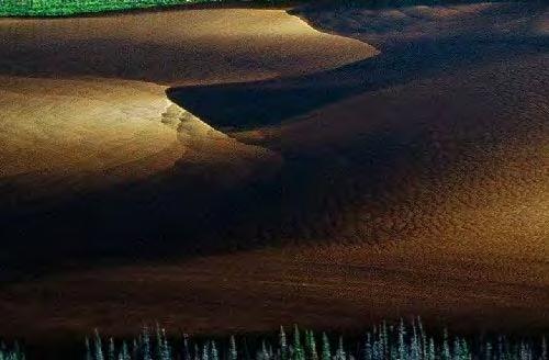
15 Inferred Soil Moisture The cross-walk for the EWC to the inferred soil moisture classes is shown in Table 2. Figure 4 provides an example of the spatial representation of the inferred soil moisture classes on a landscape. Table 2. Enhanced Wetland Classification class cross-walk to inferred soil moisture classes. Soil Moisture Enhanced Wetland Classification Classes Class Very Hydric Open Water, Aquatic Bed, Mudflats, Emergent Marsh Hydric Rich Graminoid Fen, Poor Graminoid Fen, Meadow Marsh, Shrub Swamp Subhydric Shrubby Rich Fen, Shrubby Poor Fen, Treed Rich Fen Hygric Mixedwood Swamp, Tamarack Swamp, Hardwood Swamp, Treed Poor Fen Subhygric Open Bog, Shrubby Bog, Treed Bog, Conifer Swamp Figure 4. An example of the soil moisture inferred product from an area near Ft. Nelson, BC. Ducks Unlimited Canada 15
16 Hydrodynamic Factor The lateral and vertical movement of water through wetland systems (i.e. hydrodynamics) is another important factor in the determination of wetland type. Movement of water can be groundwater or surface water, and for the purposes of this field guide groundwater movement is inferred from the position in the landscape, vegetation, and visible hydrologic features (Table 3). Hydrodynamic energy influences decomposition of organic material (by providing a mechanism for aeration), limits growth or establishment of vegetation, and stresses the vegetation due to physical damage (in higher wave energy environment areas). The hydrodynamic regime can be fairly static such as the percolation/capillary action of precipitation-driven hydrodynamics in bogs to the hydrodynamically variable marshes on exposed shores of water bodies with regular drawdowns (Figure 5). Figure 5. A marsh area in the boreal with a large difference in water table elevation throughout the growing season. Ducks Unlimited Canada 16

17 Table 3. Inferred hydrodynamic factor classes for wetlands. Class Movement of Water 1 Stagnant Stable, non-flowing areas with no vertical hydroperiod change. Movement of soil water is stagnant to very gradual, with no movement at the surface, despite constant saturation. Associated Wetland Classes Bogs, Poor Fens, Swamps 2 Slow Moving Gradual flow through with minor vertical hydroperiod change. Poor to richer Fens, Swamps, Open Water 3 Moving Vertical hydroperiod change common, lateral water movement. Rich Fens, Swamps, Marshes, Open Water 4 Dynamic Strong Vertical/Lateral movement of water. Swamps, Marshes, Open Water 5 Very Dynamic High water displacement areas. Marshes, Open Water Description of Hydrodynamic Classes Hydrodynamic Code 1 Stagnant Areas with little to no surface water movement and water table is at or below the ground surface for the entire growing season. Water movement in these areas is through capillary action in the upper layers of peat or soil. There is often little to no vertical change in water tables in these areas, with stagnant to very gradual lateral flow through these systems. The wetland classes that exhibit this hydrodynamic class include bogs, very poor fens, and poor conifer swamps. Vegetation in these areas may be treed, shrubby, bryoid, or herbaceous. Areas with this hydrodynamic class are typically the higher elevation peatland and swamp areas in the landscape. Ducks Unlimited Canada 17


18 Hydrodynamic Code 2 Slow Moving Areas with some surface water movement and the water table may be at to slightly above the surface for most of the growing season. Water movement in these areas is gradual, with some groundwater and/or surface water inputs to the system. Water levels in these areas are usually constant, with continual flows from groundwater, but extensive surface water inputs may increase the water table in these areas. The wetland classes that exhibit this hydrodynamic class include Fens and Tamarack Swamps. Vegetation may be Treed, Shrubby, Bryoid, or herbaceous, but is often associated with poor nutrient sites as the groundwater (and therefore nutrient inputs) are slighter than in other areas. Typical landscape positions are in the middle to upper elevations of peatlands, just above the main drainage areas in peatlands. Hydrodynamic Code 3 Moving Areas with surface water movement and the water table is typically above the surface for most of the growing season. Water movement is predominately lateral through these systems, but surface flows may influence the vertical change in water table during peak flow times of the year. The wetland classes that exhibit this hydrodynamic class include most of the rich fen classes (due to the increased contact with groundwater). Typical landscape positions for this class include the lower elevation peatland drainage areas. Ducks Unlimited Canada 18


19 Hydrodynamic Code 4 Dynamic Areas with significant surface water movement but water table may be at, above, or slightly below surface during the growing season. Water movement in these areas is both lateral and vertical, with large differences in surface flow that create a wide range of water table elevation throughout the year in these wetland systems. Vegetation is often treed, shrubby, or herbaceous in these areas. The wetland classes that exhibit this hydrodynamic class include swamps and shallow open water wetland classes. Typical landscape positions include the receiving slopes, drainage areas, and water bodies in local to regional lower elevation zones. Hydrodynamic Code 5 Very Dynamic Areas with a highly variable surface water movement/displacement and water table may be at, well above, or well below the surface during the growing season. Water movement in these areas is both lateral and vertical, with extreme differences in the surface flow that create the wide range of water table elevation throughout the year in these systems. Due to the highly fluctuating water table, vegetation in these areas is limited to plants that can tolerate these conditions such as emergent vegetation. No shrubs or trees are found in areas of this hydrodynamic class. Wetland classes include marshes, mudflats, and exposed areas of shallow water wetlands. Typical landscape positions include areas adjacent to water bodies, lower parts of catchments, depressions, and tidal or seche influenced mudflats along larger water bodies. Ducks Unlimited Canada 19

20 Inferred Hydrodynamics The cross-walk for the EWC to the inferred soil hydrodynmaics is shown in Table 4. Figure 6 provides an example of the spatial representation of the inferred hydrodynamic classes on a landscape. Table 4. Enhanced Wetland Classification class cross-walk to inferred hydrodynamic classes. Hydrodynamic Enhanced Wetland Classification Classes Class Very Dynamic Emergent Marsh, Mudflats, Meadow Marsh Dynamic Mixedwood Swamp, Hardwood Swamp, Shrub Swamp, Open Water, Aquatic Bed Moving Shrubby Rich Fen, Graminoid Rich Fen, Treed Rich Fen Slow Moving Treed Poor Fen, Shrubby Poor Fen, Tamarack Swamp, Graminoid Poor Fen Stagnant Open Bog, Shrubby Bog, Treed Bog, Conifer Swamp Figure 6. An example of the hydrodynamic product from an area near Ft. Nelson, BC. Ducks Unlimited Canada 20
21 Nutrient Availability Factor Nutrient availability in wetlands is often assessed with ground-based measurements of soil and water chemistry which include ph, concentrations of dissolved nutrients, and inherent soil characteristics (i.e. color, texture, structure, C:N ratio see Table 5). The degree of contact with nutrient-rich ground or surface water determines the total amount of nutrients available to the vegetation. This field guide utilizes several inferred factors that can be collected via helicopter or aircraft reconnaissance to assign a specific nutrient regime code to an overall field site location. Factors such as soil type, water color (Table 6, Figure 7), hydrology, vegetation species richness, vegetation indicator species and other factors can all be observed in the field and used in this classification. In both peatland and mineral-soil wetlands, there is a link between water chemistry (available nutrients, ph), moisture regime, and plant species assemblages. Plants, like other organisms, have a habitat niche, or a certain set of conditions, under which they thrive (live and reproduce). Some species are generalists and can thrive in a wide-range of environmental conditions (e.g., environmental variables such as moisture gradients, nutrient availability, ph, alkalinity), while others, the specialists, need a very specific set of conditions. Plant species that respond to a narrow set of environmental variables (i.e., they do not grow outside these conditions) can be used as indicators of specific ecosystems. For example, observing a high percent cover of Sphagnum fuscum would indicate low ph, relatively dry and nutrient poor environment on the peatland scale from rich fen to bog. Further, because this species does well in poor conditions and a water table that is below the surface, it can be used to predict that there is no or very little mineral water input into the system, and thus the overall nutrient status of the site is poor. This relationship of plant species and water chemistry has originally been identified by Sjörs (1952) in Swedish mires but has been adapted to North American wetlands (e.g., see NWWG 1988). Specifically in Alberta, studies by Vitt and Chee (1990) and Chee and Vitt (1989), and other similar studies showed relationships between plant assemblages and water chemistry. Such vegetation-water chemistry and moisture regime knowledge has been used extensively in the development of wetland, forest, or ecosite classification systems (e.g., see Harris et al. 1996; Archibald and Beckingham 1996; Jeglum 1971, 1973, and 1991). Often statistical programs such a TWINSPAN analysis in combination with an ordination analysis is used to correlate species presence with environmental data. These empirically-derived studies provide the basis for this guide/classification, which was then tested in the field. In general, Vitt (1994) categorized Alberta fens into three broad categories: Poor fens (ph ), poor in base cations, no or little alkalinity; moderate-rich fens (ph ), low to moderate alkalinity and concentration of cations; extreme-rich fens (ph above 7.0), high concentrations of base cations and high alkalinity, and possibly marl deposits. To make the distinctions between moderate-rich fens and extreme rich fens is very difficult in a remote sensing application, and these two fen types are grouped together as rich fens in our classification. However, this classification distinguishes poor and rich fen types based largely on nutrient status and species assemblages (see the Boreal Plains Wetland Key. Swamps, including conifer swamps, are not separated in this classification by nutrient status, even though they range from poor to very rich. This was done because in many cases, separation via remote sensing was difficult to impossible based on the spectral signatures alone. Ducks Unlimited Canada 21
22 Table 5. Ground-level determinants of nutrient regime code (adapted and expanded from Mackenzie and Moran 2004). Nutrient Regime Code Feature Specific Variable 1 Very Poor 2 Poor 3 Medium 4 Rich 5 Very Rich 6 Hyper Dissolved Nutrients Available Nutrients Very Low Low Average Plentiful Abundant Excess Water ph < > 8.0 Water Color Deep Brown - Yellow Green-Brown -Clear Green-Brown - Turbid Blue/ Green,Clear Water Ground water flow Surface Tier Saturation Stagnant Always saturated seasonal seepage Continuous Seepage Seasonal exposure of substrate Diurnal exposure Soil Plants vonpost of surface tier SurfaceTier Material Surface Peat Color C:N Ratio Relative Productivity Species Richness 1-3 Very Low Very Low High Low Low 3-6 Organic Pale 4-7 Medium Medium Medium High High 7-10 Mineral Dark Low High High 8-10 Marl Low Low N/A (Ca Rich) Eutrophic Table 6. General characteristics of water with different trophic status (adapted from Mackenzie and Moran, 2004) (also shown in Figure 9). Characteristic Nutrient Water Color Water ph Nitrogen and Nutrient Status Clarity Mineral Availability Code Dystrophic Yellow-Deep Stained < 4.5 Very Low 1 Brown Oligotrophic Greenishbrownish Clear Low 2-3 (Ca Poor) Oligotrophic Blue-Greenish Very Clear >7 Medium 3-4 Greenish- Brownish Turbid >7 High-Very High 5 Ducks Unlimited Canada 22


23 Dystrophic Oligotrophic Ca Poor Oligotrophic Ca Rich Eutrophic Figure 7. Field photos of water bodies and the association between water color and nutrient regime. Ducks Unlimited Canada 23
 conditions. Wetlands with these conditions are peatland organic soil wetland types (bogs, poor fens). The von Post of the surface organic layer is typically fibric (1-3).")

24 Description of Nutrient Regime Classes Nutrient Code 1 -Very Poor: Areas with very low available nutrients to plants, typically due to low base cation availability as a result of highly acidic (ph < 5.) conditions. Wetlands with these conditions are peatland organic soil wetland types (bogs, poor fens). The von Post of the surface organic layer is typically fibric (1-3). These areas typically have little or no contact with mineral-rich water, but the surface is typically saturated due to ombrogenous inputs. Vegetation growing in these conditions are either species adapted specifically to the conditions or generalist species that can grow over a wide range of environmental conditions. The relative number of vegetative species is very low, with a dominance of Sphagnum mosses and ericaceous shrubs. Trees, if present (trees are limited by hydric conditions as well as nutrients), are typically < 2 m tall, and are primarily stunted Black Spruce (Picea mariana). Nutrient Code 2 Poor: Areas with low available nutrients, and fairly high acidic conditions (ph ). Wetlands with these conditions are peatland organic soil wetland types (bogs, fens, and poorer conifer swamps). The von Post of the surface organic layer is typically fibric to mesic (3-6). These areas have some contact with mineral-rich water. A slightly wider range of species can be found in poor nutrient regime areas compared to very poor nutrient regime areas, including most of the dominant species found in Nutrient Code 1. Some minerotrophic species begin to occur, including bog birch (Betula spp.), Tamarack (Larix laricina), and horsetail (Equisetum fluviatile). Trees are more common to this nutrient regime (Picea mariana, Larix laricina), but heights are generally < 10 m. Ducks Unlimited Canada 24
.")
.")
25 Nutrient Code 3 Medium: Areas with fairly high available nutrients to plants, typically with slightly acidic conditions (ph ). Contact with mineral-rich water is more common to this nutrient regime compared to the poor nutrient regimes (nutrient codes 1 and 2). The dominant soil type is organic, although some mineral wetlands fall into this class. The von Post scale of decomposition (Appendix D) of the surface organic layer, if present, is mesic (4-7). Wetlands with these conditions are fens, swamps, and some poorer marshes (sedge meadow marshes typically on deposited peat soils). A wider range of minerotrophic species exists in this nutrient regime, including Caltha palustris (Marsh marigold), Petasites frigidus (Arrow-leafed Coltsfoot), and Calamagrostis canadensis (Bluejoint grass). Trees, if present, are Black Spruce and Tamarack, and can be taller than 10 meters. Nutrient Code 4 Rich: Areas with high available nutrients to plants, typically due to the more neutral ph ranges ( ). Contact with mineral-rich water is prevalent to plants in this nutrient regime. The dominant soil type is mineral, although some richer organic soil wetlands fall into this class. The von Post of the surface organic layer, if present is humic (7-10). Wetlands with these conditions are rich fens, all swamp classes, and marshes. The number of plant species in these types of wetlands is high, particularly for the herbs, forbs, and mosses. Mosses, if present, are typically brown mosses and some Sphagnum. Minerotrophic species that exist in this nutrient regime include: Juniperus communis (Common Juniper), Potentilla fruticosa (Shrubby Cinquefoil), and Parnassia palustris (Grass of Parnassis) in fens; and Salix spp. (Willows), Cornus stolonifera (Red-Osier Dogwood), and Rhamnus alnifolia (Alder-leaved Buckthorn) in swamps. Trees, if present, include all common wetland conifers and deciduous trees, and range in heights to well above 10 m. Ducks Unlimited Canada 25

, Rubus ideaeus")
26 Nutrient Code 5 Very Rich: Areas with very high available nutrients to plants and with alkaline conditions (ph ). Mineral-rich water is in constant contact with the rooting zone of plants in this nutrient regime. The dominant soil type is mineral, with marl soils in the more alkaline (near ph of 8.0) in this range. The von Post of the surface layer of organic soils, if present, are predominantly humic (8-10). Wetlands with these conditions are richer swamps, and marshes. The diversity of plant species that grow in this nutrient regime is very wide, including some species that exist in more upland areas as well, such as Rosa acicularis (Wild Rose), Rubus ideaeus (Raspberry), and Ribes spp. (Currents). Trees, if present, are typically deciduous (Betula papyrifera in palustrine wetlands, Populus tremuloides in riverine wetlands), although some conifers, including White Spruce, can occur in riverine swamps. Nutrient Code 6 Hyper: Areas with hypersaline conditions due to excess mineralrich inputs, and ph ranges are typically high (> 8.0). The high salinities found in this nutrient regime limit plant growth, and therefore this nutrient regime is found in marsh and shallow/open water wetlands only. In highly alkaline water environments, calcium carbonate (CaCO 3 ) commonly precipitates out of the water column, forming a marl substrate. Mineral and organic soils are not typically present in this class. This class is fairly rare in the Boreal Plains, occurring as marl pools or salt ponds with associated fringe marsh classes. Ducks Unlimited Canada 26

27 Inferred Nutrient Availability The cross-walk for the EWC to the inferred nutrient availability is shown in Table 7. Figure 8 provides an example of the spatial representation of the inferred nutrient availability classes on a landscape. For this inferred classification, open water was left out due to the wider range of nutrient conditions exhibited within this wetland class. Table 7. Enhanced Wetland Classification class cross-walk to inferred nutrient classes. Nutrient Class Enhanced Wetland Classification Classes Very Rich Emergent Marsh, Mudflats, Meadow Marsh Rich Mixedwood Swamp, Hardwood Swamp, Shrub Swamp, Shrubby Rich Fen, Graminoid Rich Fen, Treed Rich Fen Medium Conifer Swamp, Tamarack Swamp Poor Treed Poor Fen, Shrubby Poor Fen, Graminoid Poor Fen Very Poor Open Bog, Shrubby Bog, Treed Bog Figure 8. An example of the inferred nutrient regime product from an area near Ft. Nelson, BC. Ducks Unlimited Canada 27
28 Conclusion and Summary This guide provides an overview of the inferred products that can be derived from Ducks Unlimited Canada s Enhanced Wetland Classification (EWC). Three different inferred products can be produced: soil moisture, hydrodynamics, and nutrients. Field data from over 5,000 field sites was used to determine the predominant inferred class for each product by minor wetland class. This allows for the user to infer how water is moving though the landscape, how moist the surface is expected to be, and the inferred nutrient condition of different wetland areas across the landscape. This information can be used in conjunction with other data to better inform planning and operational practices around wetlands by government and industry partners. For more information: Data requests Alain Richard, a_richard@ducks.ca (780) Technical enquiries Kevin Smith, k_smith@ducks.ca (780) Ducks Unlimited Canada (DUC) is a private, non profit organization that conserves, manages and restores wetlands and associated habitats for waterfowl. These habitats also benefit other wildlife and people. Ducks Unlimited Canada 28
29 References Beckingham, J.D., and J.H. Archibald. 1996a. Field Guide to ecosites of northern Alberta. Nat. Resour. Can., Can. For. Serv., Northwest Reg., North. For. Cent., Edmonton, Alberta. Spec. Rep. 5. Beckingham, J.D., D.G. Nielsen, and V.A. Futoransky. 1996b. Field guide to ecosites of the mid-boreal ecoregions of Saskatchewan. Nat. Resour. Can., Can. For. Serv., Northwest Reg., North. For. Cent., Edmonton, Alberta. Spec. Rep. 6. Chee, W. and Vitt, D.H The vegetation, surface water and peat chemistry of moderate-rich fens in central Alberta, Canada. Wetlands. 9: Harris, A.G., S.C. McMurray, P.W.C. Uhlig, J.K. Jeglum, R.F. Forster, and G.D. Racey Field guide to wetland ecosystem classification for northwestern Ontario. Ont. Min. Natur. Resour., Northwest Sci. & Technol. Thunder Bay, Ont. Field Guide FG pp + Append. Jeglum, J.K Definition of trophic classes in wooded peatlands by means of vegetation types and plant indicators. Ann. Bot. Fenn. 28: Jeglum, J.K Boreal forest wetlands near central Saskatchewan. II. Relationships of vegetational variations to major environmental gradients. The Musk-ox 12: Jeglum, J.K Plant indicators of ph and water levels in peatlands at Candle Lake, Saskatchewan. Can. J. Bot. 49: Mackenzie, W.H. and J.R. Moran Wetlands of British Columbia: a guide to identification. Res. BR., B.C. Min. For., Victoria, D.C. Land Manage. Handb. No. 52. National Wetlands Working Group Wetlands of Canada. Ecological Land Classifcation Series, No. 24. Sustainable Development Branch, Environment Canada, Ottawa, Ontario, and Polyscience Publications Inc., Montreal, Quebec. 452 p. Racey, G.D., A.G. Harris, J.K. Jeglum, R.F. Foster, and G.M. Wickware Terrestrial and Wetland Ecosites of Northwestern Ontario. Ont. Min. Natur. Resour., Northwest Sci. & Technol. Field Guide FG pp. + Append. Sjörs, H On the Relation between Vegetation and Electrolytes in North Swedish Mire Waters. Oikos. 2: Smith, K.B, C.E. Smith, S.F. Forest, and A.J. Richard A Field Guide to the Wetlands of the Boreal Plains Ecozone of Canada. Ducks Unlimited Canada, Western Boreal Office: Edmonton, Alberta. 102 pp. Soil Classification Working Group The Canadian System of Soil Classification, 3rd ed. Agriculture and Agri-Food Canada Publication 1646, 187 pp. Ducks Unlimited Canada 29
30 Soil Survey Division Staff Soil Survey Manual. Agricultural Handbook No. 18 Revised. U.S. Department of Agriculture, Washington, D.C. Vitt, D.H An overview of factors that influence the development of Entm. Soc. Can. 169:7-20. Canadian peatlands. Mem. Vitt, D.H and W.L. Chee The Relationship of Vegetation to Surface Water Chemistry and Peat Chemistry in Fens of Alberta, Canada. Vegetatio. 89: Vitt, D. H., L.A. Halsey, S.C. Zoltai The bog landforms of continental western Canada in relations to climate and permafrost patterns. Arctic and Alpine Research 26 (1):1-13. Vitt, D.H., Halsey, L.A., Thormann, M.N. and Martin, T. (1996) Peatland Inventory of Alberta. Phase 1: Overview of peatland resources in the natural regions and subregions of the province. Stephen C. Zoltai Peatland Resource Center, Devonian Botanic Garden, University of Alberta, Edmonton, Alberta. Warner, B.G. and C.D.A. Rubec. (Eds.) The Canadian Wetland Classification System, Second Edition. National Wetlands Working Group. Wetlands Research Centre, University of Waterloo. Waterloo, Ontario. 68pp. Ducks Unlimited Canada 30
A guide to translate northwestern Ontario ecosites into Ecosites of Ontario
 Ministry of Natural Resources Ecological Land Classification Northwestern Ontario Science and Information Resources Division Science and Information Branch A guide to translate northwestern Ontario ecosites
This Landbase is Not Passive Connecting Boreal Wetlands to Forest Management
 This Landbase is Not Passive Connecting Boreal Wetlands to Forest Management The Role of Wetlands in Forests and Forest Management Canadian Institute of Forestry: National Electronic Lecture Series January
A GUIDE TO THE WETLAND, DEEPWATER HABITATS, AND RIPARIAN CLASSIFICATIONS USED IN WETLAND AND RIPARIAN MAPPING IN MONTANA
 A GUIDE TO THE WETLAND, DEEPWATER HABITATS, AND RIPARIAN CLASSIFICATIONS USED IN WETLAND AND RIPARIAN MAPPING IN MONTANA Purpose: The Montana Natural Heritage Program s Wetland and Riparian Mapping Center
Performance Standards for Target Hydrology
 Performance Standards for Target Hydrology Steve Eggers Senior Ecologist Regulatory Branch St. Paul District December 10, 2015 US Army Corps of Engineers Introduction Target Hydrology: the hydrology necessary
Single most important determinant of the establishment and maintenance of specific types of wetlands & wetland processes
 Wetland Ecology Lectures 12 & 13 Wetland Hydrology Hydrology Single most important determinant of the establishment and maintenance of specific types of wetlands & wetland processes Starting point of hydrological
Wetlands in Alberta: Challenges and Opportunities. David Locky, PhD, PWS, PBiol Grant MacEwan University
 Wetlands in Alberta: Challenges and Opportunities David Locky, PhD, PWS, PBiol Grant MacEwan University Overview What & Where Function & Value Alberta s Keystone Ecosystem Losses & Impacts Restoration
Bin Xu NSERC Industrial Research Chair for Colleges, Peatland Restoration NAIT
 Management and Restoration of Wooded Peatland in Alberta Bin Xu NSERC Industrial Research Chair for Colleges, Peatland Restoration NAIT Peatland Wetland with a minimum depth of 40cm peat, a deposit of
Bryophytes: Messengers from the Past; Builders of the Future
 Bryophytes: Messengers from the Past; Builders of the Future Dale H. Vitt Department of Plant Biology Southern Illinois University Carbondale, IL dvitt@siu.edu Boreal Peatlands -Some definitions -Why is
BIOMES. Living World
 BIOMES Living World Biomes Biomes are large regions of the world with distinctive climate, wildlife and vegetation. They are divided by terrestrial (land) or aquatic biomes. Terrestrial Biomes Terrestrial
38. VEGETATION Introduction. Vegetation Cook Inlet Drainages
 38. VEGETATION 38.1 Introduction The vegetation study describes the predominant vegetation types found in the Cook Inlet drainages study area. This information also helps to support wetland and habitat
HABITATS INTRODUCTION
 386 HABITATS INTRODUCTION can be defined in the landscape as mappable units and include both biotic and abiotic characteristics. This section of the Natural History of Nova Scotia deals with the habitats
Wetland Stewardship in NWT A Trail Map
 Wetland Stewardship in NWT A Trail Map Ducks Unlimited Canada has led wetland conservation efforts in Canada for the past 77 years science-based approach completed over 9500 wetland conservation projects,
Wetland Ecology Basic Principles. November 14, Kendra Moseley, Regional ESS, Soil Science Division
 Wetland Ecology Basic Principles November 14, 2018 - Kendra Moseley, Regional ESS, Soil Science Division Wetland Ecology Primary & Secondary Succession Disturbance Ecological Thresholds Ecological Dynamics
Manitoba s Submission Guidelines for Peatland Recovery Plans
 Manitoba s Submission Guidelines for Peatland Recovery Plans Peatland Management Guidebook Forestry and Peatlands Branch Manitoba Sustainable Development First Published: September 2017 Review by: 2022
Climate: describes the average condition, including temperature and precipitation, over long periods in a given area
 Ch. 6 - Biomes Section 6.1: Defining Biomes Biome: a group of ecosystems that share similar biotic and abiotic conditions, large region characterized by a specific type of climate, plants, and animals
Please see the pages below for full description of each tree!
 Tree of the Boreal Forest of Saskatchewan Major Species white spruce black spruce jack pine balsam fir tamarack trembling aspen balsam poplar white birch Minor Species bur oak American elm Manitoba maple
3.2 Biomes and Aquatic Zones
 3.2 Biomes and Aquatic Zones Learning Goals: 1. Identify a biome based on its temperature, precipitation, and dominant plant species. 2. Identify a marine life zone based on its location and amounts of
Manitoba s Submission Guidelines for Peatland Recovery Plans
 Manitoba s Submission Guidelines for Peatland Recovery Plans Peatland Management Guidebook Forestry and Peatlands Branch Manitoba Sustainable Development First Published: September 2017 Review by: 2022
Aquatic Science Unit 1. Introduction to Freshwater Ecology
 Aquatic Science Unit 1 Introduction to Freshwater Ecology Water is essential to life Water is essential to the survival of all living things No living organism can survive without water Humans cannot go
AP Environmental Science
 AP Environmental Science Types of aquatic life zones MARINE Estuaries coral reefs mangrove swamps neritic zone pelagic zone FRESHWATER lakes and ponds streams and rivers wetlands Distribution of aquatic
Deep River-Portage Burns Waterway Watershed 2015
 2.4 Soils Soil development is the product of the interaction of parent material, topography, climate, organisms and time. Understanding the types of soils that exist within a watershed and their characteristics
2015 Wildlife Action Plan Habitats Crosswalk
 2015 Wildlife Action Plan Habitats Crosswalk A crosswalk guide between Wildlife Action Plan Habitats and other habitat classification schemes. Ecosystem Comments NH WAP 2015 NHNHB System Open Water (NLCD-NHD
Ecology and Conservation of California's Coastal Freshwater Wetlands An Introduciton to the diversity of coastal freshwater wetlands Lorraine Parsons
 California s Coastal Freshwater Wetlands Lorraine Parsons Point Reyes Station, Calif. Habitat Definition Holland - e.g., Coastal and Valley Freshwater Marsh Cowardin Classification Wetlands are lands transitional
Functional Role of Wetlands in Watersheds 1
 SL 169 Functional Role of Wetlands in Watersheds 1 William F. DeBusk 2 Introduction The purpose of this fact sheet is to introduce the basic concepts of the water quality-related functions of wetlands,
The Relationship between the Properties and Features of Wetland Soils and the Adjacent Uplands
 The Relationship between the Properties and Features of Wetland Soils and the Adjacent Uplands By USDA Natural Resources Conservation Service Connecticut Staff Wetlands and watercourses are features of
The soil is a very. The soil can. The manure. Soil Characteristics. effective manure treatment system if manures are applied at the proper rate.
 The soil is a very effective manure treatment system if manures are applied at the proper rate. The soil can filter pollutants and prevent them from reaching groundwater. The manure application rate should
CHAPTER 4: CHARACTERISTICS IN ECOSYSTEMS
 1 CHAPTER 4: CHARACTERISTICS IN ECOSYSTEMS 4.3. FACTORS AFFECTING ECOSYSTEMS Pages 101-107 Nelson 1. ABIOTIC FACTORS IN TERRESTRIAL ECOSYSTEMS 2 abiotic factors are the non-living components of an ecosystem
Sage Lake Cedar Swamp Ecological Reference Area (ERA)
") Sage Lake Cedar Swamp Ecological Reference Area (ERA) Administrative Information: Sage Lake Cedar Swamp Atlanta Management Unit Compartment 12, stands 26 & 188 (Avery Hills Management Area) Montmorency
Sage Lake Cedar Swamp Ecological Reference Area (ERA) Administrative Information: Sage Lake Cedar Swamp Atlanta Management Unit Compartment 12, stands 26 & 188 (Avery Hills Management Area) Montmorency
What is a Wetland? Common Wetland Names. Wetlands: Ecotones between Upland and Aquatic Systems. Matthew J. Gray University of Tennessee.
 What is a Wetland? Matthew J. Gray University of Tennessee Common Wetland Names Backwater swamps Peatland Estuary Vernal Pools Marsh Playa Fen Bog Bayou Spring Seep Humedales Wetlands: Ecotones between
SNC1D BIOLOGY 5/10/2013. SUSTAINABLE ECOSYSTEMS L Biomes (P.16-17) Biomes. Biomes
 Biomes. Biomes") SNC1D BIOLOGY SUSTAINABLE ECOSYSTEMS L Biomes (P.16-17) Biomes Areas of the world that have a similar climate and similar organisms are known as biomes. Desert, coral reef, tundra, and tropical rainforest
SNC1D BIOLOGY SUSTAINABLE ECOSYSTEMS L Biomes (P.16-17) Biomes Areas of the world that have a similar climate and similar organisms are known as biomes. Desert, coral reef, tundra, and tropical rainforest
7.6 Wetlands, Riparian and Littoral Habitats
 7.6 Wetlands, Riparian and Littoral Habitats 7.6.1 Overview Yuba County Water Agency This section discusses wetland, riparian and littoral habitats in the vicinity 1 of Yuba County Water Agency s (YCWA
Chapter - 4 WETLAND CLASSIFICATION
 Chapter - 4 WETLAND CLASSIFICATION 4.1. GENERAL CLASSIFICATION The primary goal of wetland classification, according to Cowardin et.al (1979) is to impose boundaries on natural ecosystems for the purpose
Names: ESS 315. Lab #6, Floods and Runoff Part I Flood frequency
 Names: ESS 315 Lab #6, Floods and Runoff Part I Flood frequency A flood is any relatively high flow of water over land that is not normally under water. Floods occur at streams and rivers but can also
Wetland Animals. Grade Level: Basic or intermediate. Duration: 30 minutes 1 hour. Setting: Classroom
 Wetland Animals Wetland Animals Adapted from: Wetland Address in WOW! Wonders of Wetlands: An Educator s Guide. Bozeman: The Watercourse and Environmental Concern, Inc., 1995. Grade Level: Basic or intermediate
Manitoba s Submission Guidelines for Peatland Management Plans
 Manitoba s Submission Guidelines for Peatland Management Plans Peatland Management Guidebook Forestry and Peatlands Branch Manitoba Sustainable Development First Published: September 2017 Review by: 2022
Theme General projections Trend Category Data confidence Climatology Air temperature
 PHYSICAL EFFECTS ENVIRONMENTAL CHEMISTRY & POLLUTANTS Theme General projections Trend Category Data confidence Climatology Air temperature Precipitation Drought Wind Ice storms Water temperature Water
Canada s Boreal Forest
 Canada s Boreal Forest Canada s Boreal Forest region stretches 10,000 continuous kilometers across Canada s breadth. Its size rivals even that of the Amazon Rain Forest! As one of the world s greatest
CITY OF NEW WESTMINSTER. Bylaw No. 7033, 2005 RIPARIAN AREAS PROTECTION BYLAW
 CITY OF NEW WESTMINSTER Bylaw No. 7033, 2005 RIPARIAN AREAS PROTECTION BYLAW WHEREAS the City may preserve, protect, restore and enhance the natural environment near streams that support fish habitat from
Wetland Resources Cultural, Historical and Environmental Significance
 Wetland Resources Cultural, Historical and Environmental Significance Maryann McGraw Wetlands Program Coordinator New Mexico Environment Department Wetlands Program What is a wetland? (What is a mountain?
Tuesday, March 7, 17. Ecology: Chapter 10. Aquatic Biomes
 Ecology: Chapter 10 Aquatic Biomes Aquatic habitats= one in which the organisms live in or on Not grouped geographically the way terrestrial biomes are Difficult to be shown on a map Scattered Two types:
Biogeochemistry of Wetlands
 Institute of Food and Agricultural Sciences (IFAS) Biogeochemistry of Wetlands Si Science and da Applications Wetland Communities Wetland Biogeochemistry Laboratory Soil and Water Science Department University
Review of Natural Environment Existing Conditions, Johnston Road Study Area
 Brunton Consulting Services 216 Lincoln Heights Road, Ottawa, Ontario K2B 8A8 Phone: (613) 829-7307 Fax: (613) 829-4688 e-mail: bruntonconsulting@rogers.com January 13, 2011 Review of Natural Environment
Resource Protection Areas: Nontidal Wetlands Guidance on the Chesapeake Bay Preservation Area Designation and Management Regulations June 18, 2007
 Resource Protection Areas: Nontidal Wetlands Guidance on the Chesapeake Bay Preservation Area Designation and Management Regulations June 18, 2007 Purpose: This document provides guidance on requirements
LESSON TEN: What Is an Ecological Site and What Causes Plant Community Change?
 LESSON TEN: What Is an Ecological Site and What Causes Plant Community Change? Ecological Sites Ecological sites are a distinctive kind of land that is different from all other kinds of land based on soil
RIPARIAN AREAS REGULATION
 Definitions and interpretation RIPARIAN AREAS REGULATION 1 (1) In this regulation: Act means the Fish Protection Act; active floodplain means an area of land that supports floodplain plant species and
Wetland Observations
 Wetland Observations What is a wetland?/ Wetland Delineation Adapted from: Run for the Border and Do You Dig Wetland Soil in WOW! Wonders of Wetlands: An Educator s Guide. Bozeman: The Watercourse and
Wetland Functions in the Watershed: Part 1 Watershed Elements. USDA NRCS Module Name 1
 Wetland Functions in the Watershed: Part 1 Watershed Elements USDA NRCS Module Name 1 Objectives Define Landscape Elements in the Watershed Describe Hydrologic Connections Between Elements Introduce Soil
The water balance of wetland-dominated permafrost basins
 186 Northern Research Basins Water Balance (Proceedings of a workshop held at Victoria, Canada, March 2004). IAHS Publ. 290, 2004 The water balance of wetland-dominated permafrost basins W. L. QUINTON
Each point here will be imaged with airborne LiDAR and visited by crews to measure trees and their condition.
 2014 Interior Alaska Highlights: Forests of the Tanana Valley State Forest and Tetlin National Wildlife Refuge Alaska This briefing is a synopsis of a more detailed report that is being published by the
Chapter 3 Communities, Biomes, and Ecosystems
 Communities, Biomes, and Ecosystems Section 1: Community Ecology Section 2: Terrestrial Biomes Section 3: Aquatic Ecosystems Click on a lesson name to select. 3.1 Community Ecology Communities A biological
Western redcedar (Cw)- Thuja plicata
- Thuja plicata") Western redcedar (Cw)- Thuja plicata Tree Species > Western redcedar Page Index Distribution Range and Amplitiudes Tolerances and Damaging Agents Silvical Characteristics Genetics and Notes BC Distribution
Western redcedar (Cw)- Thuja plicata Tree Species > Western redcedar Page Index Distribution Range and Amplitiudes Tolerances and Damaging Agents Silvical Characteristics Genetics and Notes BC Distribution
Alpine larch (La) - Larix lyallii
 - Larix lyallii") Alpine larch (La) - Larix lyallii Tree Species > Alpine larch Page Index Distribution Range and Amplitiudes Tolerances and Damaging Agents Silvical Characteristics Genetics and Notes BC Distribution of
Alpine larch (La) - Larix lyallii Tree Species > Alpine larch Page Index Distribution Range and Amplitiudes Tolerances and Damaging Agents Silvical Characteristics Genetics and Notes BC Distribution of
39. WETLANDS Introduction. Wetlands and Waterbodies Cook Inlet Drainages
 39. WETLANDS 39.1 Introduction This chapter summarizes the wetlands and waterbodies study for the Cook Inlet drainages study area (Figure 39-1). The objectives of the study were to determine and map the
River Talk Patterns. Student Copy Page PART I (1 of 1) 3. Human nervous system. Waters and drainage patterns. Road system.
 3. Human nervous system. Waters and drainage patterns. Road system.") River Talk Patterns Student Copy Page PART I (1 of 1) 3 Human nervous system photo credit: Hemera Thinkstock Photos Waters and drainage patterns photo credit: Comstock Getty Images Road system photo credit:
River Talk Patterns Student Copy Page PART I (1 of 1) 3 Human nervous system photo credit: Hemera Thinkstock Photos Waters and drainage patterns photo credit: Comstock Getty Images Road system photo credit:
3 Parameters Federal/Corps. Wetland Delineation. Vegetation. Monterey County Wetlands Workshop 2/24/2014
 3 Parameters Federal/Corps Vegetation Wetland Delineation Soils Hydrology 3 Parameters but only 1 needed for State/Coastal Commission Vegetation Vegetation Soils Hydrology Sponsor: Elkhorn Slough Coastal
Appendix E Preliminary Jurisdictional Wetland Delineation Report, JYL 2008
 Appendix E Preliminary Jurisdictional Wetland Delineation Report, JYL 2008 PRELIMINARY JURISDICTIONAL WETLAND DELINEATION REPORT A portion of USS 3819 and 2664: Horton Lot and Statter Harbor Juneau, Alaska
Physiographic zones. and water quality
 Southland Physiographic zones Central Plains Technical information Physiographic zones are part of the Water and Land 2020 & Beyond project that aims to maintain and improve water quality in the Southland
How to avoid getting bogged down by the Nova Scotia Wetland Conservation Policy
 How to avoid getting bogged down by the Nova Scotia Wetland Conservation Policy for the Environmental Services Association of Nova Scotia By Krista Hilchey Wetland Specialist, Nova Scotia Environment To
Soil, Landscape, Hydrology Relationships
 Soil, Landscape, Hydrology Relationships Soil Hydrologic Cycle Unsaturated Soils with Suction (Tension) Forces Water under a suction, pulls particles together. This water is not free water, it is not free
Wetlands, Function & Value:
 Wetlands, Function & Value: Natural, Restored, & Constructed August 12, 2015 Dr. David Locky PWS, P.Biol Wetlands are the only ecosystem in the world recognized by international treaty, the Ramsar Convention
A program of the WSMD within the ANR. Determines the condition of Vermont s wetlands
 A program of the WSMD within the ANR A work in progress Links wetland impact(s) to: current condition and water quality the community structure of the flora water quality sampling Determines the condition
Wetland Delineation. Richard L. Darden, Ph.D. U.S. Army Corps of Engineers Charleston District October 3, 2012 BUILDING STRONG
 Wetland Delineation Richard L. Darden, Ph.D. U.S. Army Corps of Engineers Charleston District October 3, 2012 Why Delineate Wetlands? To define the limits of federal jurisdiction, in accordance with current
Peatland Restoration. Environment and Sustainable Resource Development
 Peatland Restoration Environment and Sustainable Resource Development Why Peatland Criteria? Equivalent Capability Carbon Sequestration Water Storage Reservoir Filter Precipitation as it recharges the
Hydrology Attribute 1/15/2016. California Rapid Assessment Method for Wetlands. Hydrology. Precipitation Increases the Extent of Wetlands
 California Rapid Assessment Method for Wetlands Hydrology Attribute Hydrology Determines existence of wetlands, drives primary physical and ecological processes: Establishment of reducing conditions Nutrient
CATEGORY a protection of the natural environment, its ecosystems and biodiversity.
 29. ENVIRONMENTAL DEVELOPMENT PERMIT AREA CATEGORY a protection of the natural environment, its ecosystems and biodiversity. The requirement to obtain an environmental development permit is cited in Section
General Riparian Vegetation Concepts. General Riparian Vegetation Concepts WHY?
 General Riparian Vegetation Concepts General Riparian Vegetation Concepts Riparian vegetation is important because: It Stabilizes streambanks with extensive root systems. Shades the water Improves water
Hydrosphere: Water Distribution
 Hydrosphere: Water Distribution 1.Think About It Why is it that the water in your bottle could have been drunk by George Washington? 2. The Hydrosphere: An Overview The hydrosphere is ALL the water on/in/over
A guide to translate central Ontario ecosites into Ecosites of Ontario
 Ministry of Natural Resources Ecological Land Classification Central Ontario A guide to translate central Ontario ecosites into Ecosites of Ontario Monique Wester, Peter Uhlig, Erin Banton and Rachelle
Restoration of Riparian Forests and Riparian Ecosystem Processes and Implications for Salmon Restoration. Katie Ross-Smith Jennifer Hammond
 Restoration of Riparian Forests and Riparian Ecosystem Processes and Implications for Salmon Restoration Katie Ross-Smith Jennifer Hammond Outline > Background California riparian communities Riparian
Sandy Wyman Rangeland Management Specialist National Riparian Service Team SRM, Feb. 6, 2013
 Assessing Proper Functioning Condition (PFC) of Lentic Areas Sandy Wyman Rangeland Management Specialist National Riparian Service Team SRM, Feb. 6, 2013 TR 1737-16 What is PFC? How well physical processes
2015 Reinvest in Minnesota (RIM) Reserve Wetlands Program
 Reserve Wetlands Program") 2015 Reinvest in Minnesota (RIM) Reserve Wetlands Program Site Evaluation Form Instructions Document 12/31/14 This instructions document is to be used for guidance in completing the Site Evaluation Form
2015 Reinvest in Minnesota (RIM) Reserve Wetlands Program Site Evaluation Form Instructions Document 12/31/14 This instructions document is to be used for guidance in completing the Site Evaluation Form
Wetland Classification: A First Step. Naomi Detenbeck, US EPA, NHEERL, Mid-Continent Ecology Division, Duluth, MN
 Wetland Classification: A First Step Naomi Detenbeck, US EPA, NHEERL, Mid-Continent Ecology Division, Duluth, MN Photos courtesy of USDA NRCS Why classify? Why classify? The overall goal of classification
Biodiversity inventories in nature protection areas terrestrial habitats
 Biodiversity inventories in nature protection areas terrestrial habitats CLIMES-symposium Remote sensing in the mapping of biodiversity, habitats and ecosystem services 6.-7.9.2012 SYKE, Helsinki Elisa
WASA Quiz Review. Chapter 2
 WASA Quiz Review Chapter 2 Question#1 What is surface runoff? part of the water cycle that flows over land as surface water instead of being absorbed into groundwater or evaporating Question #2 What are
Balsam poplar (Acb) - Populus balsamifera
 - Populus balsamifera") Balsam poplar (Acb) - Populus balsamifera Tree Species > Balsam poplar Page Index Distribution Range and Amplitiudes Tolerances and Damaging Agents Silvical Characteristics Genetics and Notes BC Distribution
Balsam poplar (Acb) - Populus balsamifera Tree Species > Balsam poplar Page Index Distribution Range and Amplitiudes Tolerances and Damaging Agents Silvical Characteristics Genetics and Notes BC Distribution
Chapter 40a. Ch. 52 An Introduction to Ecology and the Biosphere
 Chapter 40a Ch. 52 An Introduction to Ecology and the Biosphere Ecology: the scientific study of the interactions between organisms and the environment The ecological study of species involves biotic and
Appendix I. Potential Adverse Change to Wetland Function Methodology and Results
 Appendix I Potential Adverse Change to Wetland Function Methodology and Results Technical Memorandum North Florida Regional Water Supply Plan Potential Adverse Change to Wetland Function January 3, 2017
Regulatory and Assessment Challenges for Muskeg Soil at Oil and Gas Sites in Northeast BC
 Regulatory and Assessment Challenges for Muskeg Soil at Oil and Gas Sites in Northeast BC Tom Frkovich, P.Geo. SynergyAspen Environmental 2013 Remediation Technologies Symposium Regulatory and Assessment
Western white pine (Pw) - Pinus monticola
 - Pinus monticola") Western white pine (Pw) - Pinus monticola Tree Species > Western white pine Page Index Distribution Range and Amplitiudes Tolerances and Damaging Agents Silvical Characteristics Genetics and Notes BC Distribution
Western white pine (Pw) - Pinus monticola Tree Species > Western white pine Page Index Distribution Range and Amplitiudes Tolerances and Damaging Agents Silvical Characteristics Genetics and Notes BC Distribution
Stand structural attributes and canopy lichen diversity in B.C. s Inland Temperate Rainforest, Upper Fraser River Valley Watershed.
 Stand structural attributes and canopy lichen diversity in B.C. s Inland Temperate Rainforest, Upper Fraser River Valley Watershed. Darwyn Coxson, University of Northern British Columbia, 3333 University
Resolution : of a degree which corresponds to approximately 25 meters
 Canada Land Inventory (CLI) CANADA LAND INVENTORY LEVEL I LAT/LON DIGITAL DATA REVISED EDITION LAND CAPABILITY FOR WILDLIFE-WATERFOWL 1. Coverage Specifications Original Map Scale: 1:250,000 Resolution
Change Monitoring Inventory
 Change Monitoring Inventory Ground Sampling Quality Assurance Standards Prepared by Ministry of Forests Resources Inventory Branch for the Terrestrial Ecosystem Task Force Resources Inventory Committee
Southern Africa perspective - Identification and Mapping National Freshwater Ecosystems Priority Areas in South Africa
 Southern Africa perspective - Identification and Mapping National Freshwater Ecosystems Priority Areas in South Africa SA National Wetland Inventory By N Mbona Outline National Wetland Inventory SA Wetland
Forest and climate change
 Forest and climate change Seppo Kellomäki University of Eastern Finland School of Forest Sciences Joensuu Campus Finland 1 Contents Forests in the world Global climate change and impacts on forests Climate
Wetland Vegetation Monitoring Protocol
 Wetland Vegetation Monitoring Protocol Terrestrial Long-term Fixed Plot Monitoring Program Regional Watershed Monitoring and Reporting November 2011 Report prepared by: Natasha Gonsalves, Environmental
Think About It (not on notes)
") Aquatic Ecosystems Think About It (not on notes) We call our planet Earth, yet nearly three-fourths of Earth s surface is covered with water. Despite the vital roles aquatic ecosystems play in the biosphere,
Aquatic Ecosystems Think About It (not on notes) We call our planet Earth, yet nearly three-fourths of Earth s surface is covered with water. Despite the vital roles aquatic ecosystems play in the biosphere,
AND WHEREAS the Minister is satisfied that all the requirements of the Act have been met, including those required of Premier Tech;
 PROVINCE OF SASKATCHEWAN MINISTRY OF ENVIRONMENT MINISTERIAL APPROVAL PURSUANT TO SECTION 15(1)(a) THE ENVIRONMENTAL ASSESSMENT ACT PREMIER TECH HORTICULTURE LTD. SMOKEY RIDGE PEAT HARVESTING PROJECT WHEREAS
What factors affect life in aquatic ecosystems?
 Aquatic Ecosystems: Notes Outline Today s Objective: Students will explain that different types of organisms exist within aquatic systems due to chemistry, geography, light, depth, salinity, and/or temperature.
The Water Council would like to thank all those who provided information, photos and advice for the development of this document.
 The Water Council would like to thank all those who provided information, photos and advice for the development of this document. Special thanks to: Government of Manitoba Ducks Unlimited Canada Gordon
Background. AEM Tier 2 Worksheet Stream & Floodplain Management. Glossary
 AEM Tier 2 Worksheet Stream & Floodplain Management Glossary Bankfull Stage: The stage at which water starts to flow over the flood plain; the elevation of the water surface at bankfull discharge. (This
Hydrologic Indicators
 Hydrologic Indicators Courtney M. Stevens Regulatory Specialist Coastal Branch December 8, 2011 US Army Corps of Engineers HYDROLOGY Some Factors that Influence the Wetness of a Site Climate Landscape
TODAY S GOALS. Intro to water and environmental issues
 TODAY S GOALS Intro to water and environmental issues Ecosystems Biomes Watershed Global water use and budgeting At the end of the class, we should be able to understand the complexity of water resources
Movement and Storage of Groundwater The Hydrosphere
 Movement and Storage of Groundwater The Hydrosphere The water on and in Earth s crust makes up the hydrosphere. About 97 percent of the hydrosphere is contained in the oceans. The water contained by landmasses
Enclosed farmland: Arable and Horticultural, Improved and Neutral Grasslands
 executive summary Executive summary 1 Countryside Survey 2000 (CS2000) and the Northern Ireland Countryside Survey 2000 (NICS2000) have been designed to provide detailed information about the habitats
WETLAND DETERMINATION DATA FORM Eastern Mountains and Piedmont
 WETLAND DETERMINATION DATA FORM Eastern Mountains and Piedmont Project/Site: PIK-104-10.62 (PID: 83667) City/County: Pike Sampling Date: 5.30.13 Applicant/Owner: ODOT State: OH Sampling Point: 36 Investigator(s):
WONDERFUL, WATERFUL WETLANDS
 WONDERFUL, WATERFUL WETLANDS OBJECTIVES The student will do the following: 1. List characteristics of wetlands. SUBJECTS: Science, Language Arts TIME: 60 minutes 2. Describe the functions of a wetland.
Ponderosa pine (Py) - Pinus ponderosa
 - Pinus ponderosa") Ponderosa pine (Py) - Pinus ponderosa Tree Species > Ponderosa pine Page Index Distribution Range and Amplitiudes Tolerances and Damaging Agents Silvical Characteristics Genetics and Notes BC Distribution
Ponderosa pine (Py) - Pinus ponderosa Tree Species > Ponderosa pine Page Index Distribution Range and Amplitiudes Tolerances and Damaging Agents Silvical Characteristics Genetics and Notes BC Distribution
Ecology and Stewardship of NH Wetlands
 Ecology and Stewardship of NH Wetlands Emily Preston NH Fish and Game Dept. With thanks to Emma Tutein UNH Cooperative Extension A Wetland is a Wetland? 1 Wetlands in New Hampshire Env-Wt 101.99 NH Code
Ecology and Stewardship of NH Wetlands
 Ecology and Stewardship of NH Wetlands Emily Preston NH Fish and Game Dept. With thanks to Emma Carcagno UNH Cooperative Extension A Wetland is a Wetland? 1 Wetlands in New Hampshire Env-Wt 101.99 NH Code
d. Estimated potential indirect impacts to ombrotrophic bog communities due to proposed mine dewatering should not be rated as no effect.
 CEMVP-OP-R (MVP-1999-5528-JKA) 15 January 2015 MEMORANDUM SUBJECT: Response to Public Comments on Distinguishing Ombrotrophic and Somewhat Minerotrophic Bog Communities for Purposes of Estimating Potential