Documentation of Groundwater Model
|
|
|
- Wilfred Reynolds
- 5 years ago
- Views:
Transcription
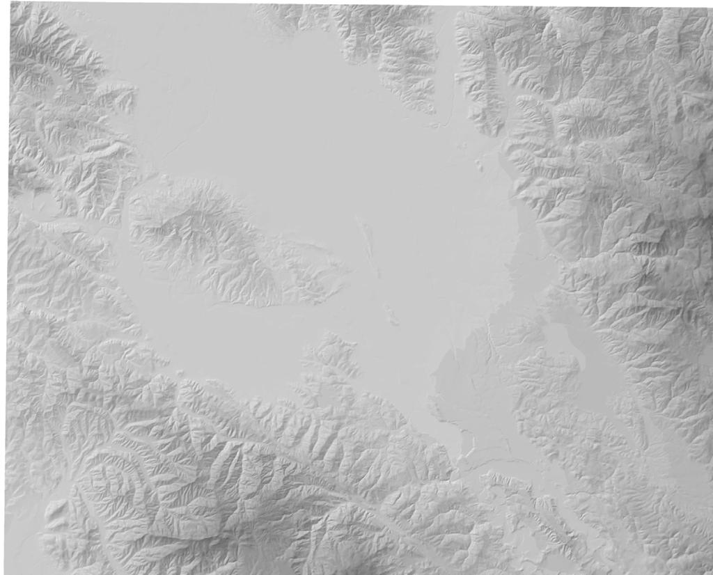
1 Documentation of Groundwater Model Groundwater Model The primary tool used to evaluate potential impacts on groundwater was a groundwater flow and solute transport model developed by San Benito County Water District and San Benito County. The model was first developed and documented in 2 (Yates and Zhang 1) but has evolved since then, including modifications implemented specifically to better evaluate impacts of the wastewater project. The model is regional in extent, covering the entire San Benito County part of the Gilroy-Hollister groundwater basin. The groundwater flow component of the model uses the MODFLOW0 computer program developed by the U. S. Geological Survey (Harbaugh and others, 0). Groundwater salinity is simulated using the solute transport program MT3DMS (Zheng and Wang, 1999), which functions as an extension to MODFLOW0. Numerous spreadsheets, geographic information system (GIS) maps and Fortran utility programs were also developed to prepare input data sets for the models and to extract and display selected simulation results. The finite-difference model grid includes five layers to enable simulation of vertical differences in groundwater levels and salt concentration. Grid cells are 250 x 250 feet near the DWTP and IWTP and increase to 1000 x 1000 feet in the rest of the basin. Figure A-1 shows the the extent of the model and the finite-difference grid used in the model to simulate water levels at discrete points across the basin. The model has continued to evolve since 1 as new information becomes available and to improve its capabilities. This includes modifications specifically implemented for the wastewater project. Modifications implemented since 1 include: The grid spacing was decreased in the vicinity of the DWTP and IWTP in order to provide greater detail in simulated water table mounding beneath the percolation ponds. The model was divided into five layers in order to represent vertical differences in water levels and salinity. The upper surface of the top layer (layer 1) was shaped to parallel the relatively low water table surface at the start of the calibration period. This helps prevent layer 1 cells from going dry when simulated water levels fall below the bottom elevation of layer 1. The original calibration period was January 1993 to September 0. This was extended through September 3. The model uses quarterly time intervals for transient simulations. The active part of the flow domain was expanded to include the Lomerias Muertas/Flint Hills area and the Hollister Hills area that projects north from near San Justo Reservoir. Subsurface permeability is lower in these hilly areas than in the valley floor areas, but they are all part of a single, continuous groundwater flow system. The original model had excluded these areas. They were added to the model in order to explore potential impacts on the groundwater contaminant
2 plume at the former Whittaker ordnance facility and on groundwater flow and salinity near the proposed Flint Hills sprayfield site. The simulation of salt loading was completely revised to include separate loads from individual sources (stream percolation; wastwater percolation; recharge from rainfall and irrigation water, etc.) and to simulate loads on a transient basis. Salt loading by deep percolation of infiltrated rainfall and irrigation water was converted to a spatially variable input by calibrating a background mass load based on local groundwater salinity and irrigation water salinity. The background mass load represents all sources of dissolved solids in the deep percolation other than irrigation water (gypsum, fertilizers, atmospheric deposition, and dissolution of soil minerals) and was calibrated so that simulated deep percolation salinity equaled shallow groundwater salinity. Shallow groundwater salinity was set equal to the average of ten shallow wells in the San Juan Valley (2,330 mg/l) because spatial variability and lack of data in other parts of the basin precluded regional contouring of shallow groundwater salinity. However, measured TDS concentrations in shallow wells near the DWTP, IWTP and airport were included as localized areas of detail. Recharge zones for future simulations were revised to conform with the 2 land use survey completed by the California Department of Water Resources and to include separate zones for wastewater disposal and reuse areas. The model calibration period was simulated using the 1997 land use survey. The recharge preprocessor was modified to account for recharge on peripheral hills that are not included in the active part of the model flow domain. Mathematical functions relating stream depth, width and dissolved-solids concentration to stream flow were greatly improved based on new field data collected by SBCWD in 4. The MODPATH extension to the MODFLOW model code was implemented to simulate the Whittaker contaminant plume path The ZONEBUDGET extension to MODFLOW was implemented to obtain water budget information for subregions of the model flow domain. Inflow to the basin through alluvium along creeks (Pacheco Creek, Arroyo de las Viboras, Arroyo Dos Picachos, Tres Pinos Creek and the San Benito River was represented by general-head boundaries. Inflow beneath the Pajaro River from the Llagas area was similarly represented. The conductance terms for these inflows were calibrated to obtain reasonable inflow rates comparable to the estimated inflows in water budgets developed for SBCWD annual groundwater reports. The model was completely recalibrated. This included redefining zones of hydraulic conductivity and storativity, adjusting their parameter values, adjusting the locations and conductances of faults, and adjusting streambed permeability. Shallow wells were added to the calibration data set to support calibration of vertical hydraulic conductivity. Hydrographs of simulated and measured water levels at 16 of the 106 well locations used for model calibration are shown in Figure A-2. These are wells located in areas that would be affected by the wastwater project, and their locations are labeled in Figure A-1.
3 The model uses quarterly stress periods and was calibrated to measured groundwater levels and stream-aquifer fluxes during Calibration of the flow component of the model is good in all subbasins. The ability of the solute transport component of the model to correctly simulate existing TDS concentration at any point in the basin is limited. Salinity data are fairly sparse, especially for shallow aquifers. Available data show considerable spatial variability geographically and with depth. Because of this variability, contoured initial concentrations for deep aquifers (model layers two through five) are not highly reliable except near the measurement wells. There were too few points to allow regional contouring of salinity in shallow aquifers (model layer 1), Instead, an initial concentration equal to the average of all available measurements was used in all parts of the basin except areas near the DWTP, IWTP and airport, for which one or more measured values were available. The solute transport model also simplifies water quality processes by lumping all salt loads other than irrigation water into a single background mass load term that was calibrated using an assumption that existing shallow groundwater salinity is in equilibrium with recharge salinity. Because of these simplifying assumptions, the solute transport component of the model is primarily useful for comparing relative differences among alternatives rather than predicting absolute TDS concentrations.
4
5 M G Sim L3 Screened Sim L4 Sim L5 Sim L3 Screened Sim L4 Screened Sim L5 Screened Near San Juan MW D /4-34H1 (layers 4-5) San Juan MW-6 (Layer 1) Sim L1 Sim L2 Sim L3 Sim L4 Sim L Figure A-2 C continued 10/20/6 HydrographsML5_selected.xls
6 R Q DWTP_MW Measured Sim L1 Screened Sim L2 Screened DWTP 97-2D DWTP 97-4D Sim L3 Sim L4 Screened Sim L J1 250 Measured Sim L1 Screened Sim L2 Saved L1 1 Layer Model Screened Figure A-2 C continued 10/20/6 HydrographsML5_selected.xls
7 K C N Measured Sim L1 Screened Sim L2 Screened J Measured Sim L1 Screened Sim L2 Screened Sim L3 Screened Sim L4 Sim L5 Figure A-2. Simulated and Measured Groundwater Levels for the Calibration Simulation at Selected Locations Potentially Affected by the Proposed Project 10/20/6 HydrographsML5_selected.xls
8 Near San Juan MW-10 IWTP_MW /5-28N1 San_Juan_MW-10 Sim L1 sim L2 Sim L3 Sim L4 Sim L E Measured Sim L1 Screened Sim L B Measured Sim L1 Screened Sim L2 IWTP MW-2 Figure A-2 C continued 10/20/6 HydrographsML5_selected.xls
9
10
4.2 HYDROLOGY AND WATER QUALITY
 4.2 HYDROLOGY AND WATER QUALITY 4.2.1 INTRODUCTION This section provides information regarding hydrology and water quality in the vicinity of the proposed reclaimed water use areas. Following an overview
5. Basin Evaluation Salt and Nitrate Balance
 SNMP Attachment B, Section B.2.1.3 (originally Section 5 in CV-SALTS Phase 2 Conceptual Model Task 5 deliverables) 5. As part of the evaluation of water quality the SNMP requires loading estimates and
 5. MODEL DESCRIPTION Several models were used in combination to estimate the impacts of the proposed 100,000 acre-ft dryyear yield program. MODFLOW and MODPATH were used to estimate the groundwater and
Optimizing Recharge in the Pauba Valley
 ABSTRACT & POWERPOINT PRESENTATION Optimizing Recharge in the Pauba Valley Daniel J. Craig Senior Hydrgeologist Alameda, California Managed Aquifer Recharge Symposium January 25-26, 2011 Irvine, California
4.4 MODEL CODE DESCRIPTION 4.5 WATER SOURCES AND SINKS 4.6 MODEL DOMAIN AND BOUNDARIES. SLR South Africa
 Page 4-18 The developed model should therefore be seen as an initial site model which should be refined and recalibrated once more groundwater monitoring and other data become available. 4.4 MODEL CODE
Draft Fact Sheet Butte County Stable Isotope Recharge Study
 Agenda Item #4 Draft Fact Sheet Butte County Stable Isotope Recharge Study Purpose of the Study: To develop a better understanding of how various water sources contribute to recharge of Butte County groundwater.
San Mateo Plain Groundwater Basin Assessment Stakeholder Workshop #8 17 APRIL 2018
 San Mateo Plain Groundwater Basin Assessment Stakeholder Workshop #8 17 APRIL 2018 PRESENTATION OVERVIEW Introductions Project Overview Summary of Analysis Supporting Model Development Model Development
Assessment of the Groundwater Quantity Resulting from Artificial Recharge by Ponds at Ban Nong Na, Phitsanulok Province, Thailand
 Research article erd Assessment of the Groundwater Quantity Resulting from Artificial Recharge by Ponds at Ban Nong Na, Phitsanulok Province, Thailand SIRIRAT UPPASIT* Faculty of Technology, Khon Kaen
June 4, Mr. Arden Wallum General Manager Mission Springs Water District Second Street Desert Hot Springs, CA Dear Mr.
 June 4, 2015 Mr. Arden Wallum General Manager Mission Springs Water District 66575 Second Street Desert Hot Springs, CA 92240 Dear Mr. Wallum: Thank you for your letter and participation in the Coachella
Groundwater in the Santa Rosa Plain
 . Groundwater in the Santa Rosa Plain Marcus Trotta, PG, CHg Principal Hydrogeologist Sonoma County Water Agency Santa Rosa Plain Groundwater Sustainability Agency October 12, 2017 www.sonomacountywater.org
4 Water Management Strategies
 4 Water Management Strategies This section meets the following IRWMP Standard from the Integrated Regional Water Management Grant Program Guidelines. D. Water Management Strategies Document the range of
San Mateo Plain Groundwater Basin Assessment Stakeholder Workshop #7 9 NOVEMBER 2017
 San Mateo Plain Groundwater Basin Assessment Stakeholder Workshop #7 9 NOVEMBER 2017 PRESENTATION OVERVIEW Introductions Project Overview Stakeholder Outreach Summary Phase 2 Updates Modeling Activities
San Benito County Water District. Annual Groundwater Report 2017
 San Benito County Water District Annual Groundwater Report 2017 ANNUAL GROUNDWATER REPORT WATER YEAR 2017 DECEMBER 2017 (This page has been left blank intentionally.) WATER YEAR 2017 TABLE OF CONTENTS
Potential effects evaluation of dewatering an underground mine on surface water and groundwater located in a rural area
 Potential effects evaluation of dewatering an underground mine on surface water and groundwater located in a rural area ITRODUCTIO Michel Mailloux* Eng. M.Sc, Vincent Boisvert, M.Sc, Denis Millette, Eng.,
Numerical Groundwater Model for the Kaweah Delta Water Conservation District
 Numerical Groundwater Model for the Kaweah Delta Water Conservation District Nels Ruud and Peter Leffler Fugro West, Inc. Larry Dotson Kaweah Delta Water Conservation District Presentation Outline Background
List of Tables... ii. List of Figures... ii. Executive Summary... ES - 1. Section 1: Introduction
 Table of Contents List of Tables... ii List of Figures... ii Executive Summary... ES - 1 Section 1: Introduction... 1-1 1.1 Modeling Objective... 1-1 1.2 Work Flow... 1-2 Section 2: Develop Hydrogeological
Modeling the Contamination of an Aquifer from a Highway Salt Storage Facility
 First International Conference on Saltwater Intrusion and Coastal Aquifers Monitoring, Modeling, and Management. Essaouira, Morocco, April 23 25, 01 Modeling the Contamination of an Aquifer from a Highway
List of Tables... iii List of Figures... iii Executive Summary... ES - i
 Table of Contents List of Tables... iii List of Figures... iii Executive Summary... ES - i Section 1: Introduction... 1-1 1.1 Background... 1-1 1.2 Purpose, Scope, and Modeling Objective... 1-2 Section
6.0 USGS MODEL. 6.1 Background
 6.0 USGS MODEL 6.1 Background A groundwater flow model is a simplification of a real groundwater flow system. Real groundwater flow systems are complex, and they are often simplified with a model for the
Investigation of sustainable development potential for Ulubey Aquifer System, Turkey
 doi:10.5194/piahs-364-513-2014 Evolving Water Resources Systems: Understanding, Predicting and Managing Water Society Interactions Proceedings of ICWRS2014, Bologna, Italy, June 2014 (IAHS Publ. 364, 2014).
Dynamic groundwater-river interaction model for planning water allocation in a narrow valley aquifer system of the Upper Motueka catchment
 Dynamic groundwater-river interaction model for planning water allocation in a narrow valley aquifer system of the Upper Motueka catchment Timothy Hong t.hong@gns.cri.nz Gilles Minni g.minni@gns.cri.nz
SAN MATEO PLAIN GROUNDWATER BASIN ASSESSMENT STAKEHOLDER WORKSHOP#2 SEPTEMBER 7, 2016
 SAN MATEO PLAIN GROUNDWATER BASIN ASSESSMENT STAKEHOLDER WORKSHOP#2 SEPTEMBER 7, 2016 PRESENTATION OVERVIEW Introductions Project Overview Summary of Stakeholder Meeting #1 Feedback Snapshot of Results
Numerical Modeling of Groundwater Flow in the Navajo Sandstone Aquifer at the Tuba City, Arizona, Disposal Site 15167
 Numerical Modeling of Groundwater Flow in the Navajo Sandstone Aquifer at the Tuba City, Arizona, Disposal Site 15167 ABSTRACT Richard Bush*, Timothy Bartlett** *US DOE, Office of Legacy Management **Stoller
Appendix I. Groundwater Modeling
 Appendix I. Groundwater Modeling This appendix describes current and future groundwater modeling efforts associated with the. 0 I. Current Objectives of Groundwater Modeling Efforts The objectives of groundwater
B-7. Predictive Assessment Model of Quaternary Alluvium Hydrogeology. J:\scopes\04w018\10000\FVD reports\final EIA\r-EIA app.doc
 B-7 Model of Quaternary Alluvium Hydrogeology J:\scopes\04w018\10000\FVD reports\final EIA\r-EIA app.doc PREDICTIVE ASSESSMENT MODELING OF THE QUATERNARY ALLUVIUM HYDROGEOLOGY EAGLE PROJECT MARQUETTE COUNTY,
Evaluating Impoundment Closure Scenarios using Fate and Transport Modeling
 2017 World of Coal Ash (WOCA) Conference in Lexington, KY - May 9-11, 2017 http://www.flyash.info/ Evaluating Impoundment Closure Scenarios using Fate and Transport Modeling Jacob J. Walczak 1, Meng Wang
Memorandum. Introduction. Carl Einberger Joe Morrice. Figures 1 through 7
 Memorandum TO: Michelle Halley, NWF DATE: October 9, 2007 FROM: Carl Einberger Joe Morrice PROJ. NO.: 9885.000 CC: Project File PROJ. NAME: National Wildlife Federation ATTACHMENTS: Tables 1 through 6
Section 8 Stevinson Water District Study Area
 Stevinson Water District Study Area Figure 8-1. Location of Stevinson Water District & the Merquin County Water District (SWD 2005). 8.1 Introduction and Overview The Stevinson Water District (SWD) is
HARGIS + ASSOCIATES, INC. HYDROGEOLOGY ENGINEERING
 HYDROGEOLOGY ENGINEERING La Jolla Gateway 9171 Towne Centre Drive, Suite 375 San Diego, California 92122 Phone: 858.455.6500 Fax: 858.455.6533 VIA E-MAIL Principal Hydrogeologist ORANGE COUNTY WATER DISTRICT
SALINAS VALLEY GROUNDWATER BASIN SETTING INITIAL REVIEW FOR DEVELOPMENT OF GROUNDWATER SUSTAINABILITY PLAN
 1 SALINAS VALLEY GROUNDWATER BASIN SETTING INITIAL REVIEW FOR DEVELOPMENT OF GROUNDWATER SUSTAINABILITY PLAN May 10, 2018 Prepared for Salinas Valley Basin Groundwater Sustainability Agency Outline Purpose
Salt and Nitrate Sources Pilot Implementation Study Report
 FEBRUARY 2010 CV- SALTS Salt and Nitrate Sources Pilot Implementation Study Report Submitted by: LARRY WALKER ASSOCIATES LUHDORFF & SCALMANINI CONSULTING ENGINEERS SYSTECH WATER RESOURCES, INC. NEWFIELDS
Genetic Algorithm based Simulation Optimization Approach to Seawater Intrusion
 International Symposium on Genetic Algorithm based Simulation Optimization Approach to Seawater Intrusion 1313 Integrated Water Resources Management (IWRM 2014) February 19 21, 2014, CWRDM, Kozhikode,
Appendix C Data Collection Protocols
 INTEGRATED REGIONAL GROUNDWATER MANAGEMENT PLAN Appendix C Data Collection Protocols STANISLAUS & TUOLUMNE RIVERS GROUNDWATER BASIN ASSOCIATION GROUNDWATER MONITORING PROTOCOL FOR MEASURING STATIC GROUNDWATER
Modeling the Managed Aquifer Recharge for Groundwater Salinity Management in the Sokh River Basin
 Modeling the Managed Aquifer Recharge for Groundwater Salinity Management in the Sokh River Basin A. Karimov, 1 I. Gracheva, 2 F. Miryusupov 2 1 International Water Management Institute (IWMI) Central
Surface Water and Seawater Interactions in the Coastal Environment of Biscayne Bay, Southeast Florida
 Surface Water and Seawater Interactions in the Coastal Environment of Biscayne Bay, Southeast Florida William C. Hutchings, MS, PG Nicholas Albergo, PE, DEE Paper No. 191-8 2005 Salt Lake City Annual Meeting
MODELLING THE GROUNDWATER FLOW FOR ESTIMATING THE PUMPING COST OF IRRIGATION IN THE AQUIFER OF N. MOUDANIA, GREECE
 Proceedings of the 13 th International Conference on Environmental Science and Technology Athens, Greece, 5-7 September 2013 MODELLING THE GROUNDWATER FLOW FOR ESTIMATING THE PUMPING COST OF IRRIGATION
Orange County Water District. Salt and Nitrate Projections for Orange County Management Zone. Final Technical Memorandum
 Orange County Water District Salt and Nitrate Projections for Orange County Management Zone Final Technical Memorandum Prepared by Greg D. Woodside, P.G., C.Hg. July 18, 2016 Table of Contents SECTION
Nitrate Tracking in the Lower Yakima Basin
 Nitrate Tracking in the Lower Yakima Basin Matt Bachmann, Ph.D. September 19 th, 2013 U.S. Department of the Interior U.S. Geological Survey GWMA objectives reduce nitrate concentrations in groundwater
ZEBRA MUSSEL PROJECT STATUS
 ZEBRA MUSSEL PROJECT STATUS San Benito County Water District July 8, 2008 Reviewed by: Prepared by: Ali Hasan Christopher Dinsmore, PE Introduction HDR has been contracted with San Benito County Water
CHAPTER 7 GROUNDWATER FLOW MODELING
 148 CHAPTER 7 GROUNDWATER FLOW MODELING 7.1 GENERAL In reality, it is not possible to see into the sub-surface and observe the geological structure and the groundwater flow processes. It is for this reason
AQUIFER STORAGE AND RECOVERY EVALUATION REPORT
 AQUIFER STORAGE AND RECOVERY EVALUATION REPORT Prepared for: CLALLAM COUNTY 228 East 4 th Street, Port Angeles, WA 98362 Prepared by: 12100 NE 195 th Street, Suite 200, Bothell, WA 99011 July 2003 TABLE
GAM RUN : IRION COUNTY WATER
 GAM RUN 12-017: IRION COUNTY WATER CONSERVATION DISTRICT MANAGEMENT PLAN by William Kohlrenken Texas Water Development Board Groundwater Resources Division Groundwater Availability Modeling Section (512)
D.G.S.W. Pitakumbura Manager (Groundwater Studies) Groundwater Section NWS&DB. Groundwater recharge or deep drainage or
 Groundwater Section NWS&DB. Groundwater recharge or deep drainage or") Groundwater Recharge and Extraction Techniques D.G.S.W. Pitakumbura Manager (Groundwater Studies) Groundwater Section NWS&DB What is Groundwater Recharge Groundwater recharge or deep drainage or deep percolation
Groundwater Recharge and Extraction Techniques D.G.S.W. Pitakumbura Manager (Groundwater Studies) Groundwater Section NWS&DB What is Groundwater Recharge Groundwater recharge or deep drainage or deep percolation
DYNFLOW accepts various types of boundary conditions on the groundwater flow system including:
 Section 6 Groundwater Flow Model A groundwater flow model was developed to evaluate groundwater flow patterns in the site area and to provide a basis for contaminant transport modeling. 6.1 Model Code
GROUND WATER/SURFACE WATER INTERACTIONS AWRA SUMMER SPECIALTY CONFERENCE Judith Schenk'
 July 1-3 GROUND WATER/SURFACE WATER INTERACTIONS AWRA SUMMER SPECIALTY CONFERENCE 2002 326x6 pjf= INTEGRATION OF DATA USING GIS AND STATEPP TO ESTIMATE GROUNDWATER MODEL INPUT PARAMETERS Judith Schenk'
Using the Waste Load Allocation Model (WLAM) to Develop Effluent Limitations and Waste Discharge Requirements
 to Develop Effluent Limitations and Waste Discharge Requirements") Using the Waste Load Allocation Model (WLAM) to Develop Effluent Limitations and Waste Discharge Requirements Background The Regional Water Quality Control Board establishes water quality objectives to
Using the Waste Load Allocation Model (WLAM) to Develop Effluent Limitations and Waste Discharge Requirements Background The Regional Water Quality Control Board establishes water quality objectives to
San Benito County Water District
 30 Mansfield Road P.O. Box 899 Hollister, CA 95024-0899 Phone: (831) 637-8218 Fax: (831) 637-7267 DATE: June 22, 2010 TO: FROM: SUBJECT: Governor s Office of Planning and Research/State Clearinghouse Unit,
Overview of Water Resources (Part 2): Groundwater in Sonoma Valley
: Groundwater in Sonoma Valley") . Overview of Water Resources (Part 2): Groundwater in Sonoma Valley Marcus Trotta, PG, CHg Principal Hydrogeologist Sonoma County Water Agency Sonoma Valley Groundwater Sustainability Agency October 23,
. Overview of Water Resources (Part 2): Groundwater in Sonoma Valley Marcus Trotta, PG, CHg Principal Hydrogeologist Sonoma County Water Agency Sonoma Valley Groundwater Sustainability Agency October 23,
Michael Roark, USGS Nabil Shafike, ISC Technical Review - October 14, 2010
 Michael Roark, USGS Nabil Shafike, ISC Technical Review - October 14, 2010 Area of Significant GW/SW Interaction Middle Valley System Several diversion structures divert river flows to a system of canals.
Memorandum of Understanding to Implement the Cooperative Agreement. Accepted: Wednesday, January 14, 2009
 Memorandum of Understanding to Implement the Cooperative Agreement Accepted: Wednesday, January 14, 2009 The Cooperative Agreement to Protect Water Quality and Encourage the Conjunctive Uses of Imported
GROUNDWATER & SGMA 101
 GROUNDWATER & SGMA 101 Santa Cruz Mid-County GSA Public Orientation Workshop #1 Presenter: Derrik Williams, HydroMetrics Water Resources Inc. Thursday, October 5, 2017 Session Objectives 1. Understanding
Lower Rio Grande Salinity Monitoring
 Lower Rio Grande Salinity Monitoring Chad Johannesen, DBS&A Beiling Liu, NM Interstate Stream Commission James F. Hogan, NM Environment Department Amy Ewing, DBS&A Chris Wolf, DBS&A Rio Grande Surface
Coachella Valley Regional Water Management Group (CVRWMG)
") April 13, 2015 SNMP Overview Introduction Regulatory Framework Water Quality Objectives Basin Characterization Ambient Water Quality and Assimilative Capacity Estimate of Future Water Quality Salt and
April 13, 2015 SNMP Overview Introduction Regulatory Framework Water Quality Objectives Basin Characterization Ambient Water Quality and Assimilative Capacity Estimate of Future Water Quality Salt and
Lower Tuscan Aquifer. General Description PowerPoint
 Lower Tuscan Aquifer Monitoring, Recharge & Data Management Project General Description PowerPoint General Description Overview Project Purpose Project Overview Outreach Next Steps 2 Project Purpose Field
Stormwater Retention Pond Recovery Analysis
 Stormwater Retention Pond Recovery Analysis By Nicolas E Andreyev The first in a series of courses on Green Drainage Design www.suncam.com Page 1 of 33 Forward To design a stormwater retention pond, one
Numerical Groundwater Flow Model Report. Caloosa Materials, LLC 3323 Gulf City Road Ruskin, Florida 33570
 Numerical Groundwater Flow Model Report Caloosa Materials, LLC 3323 Gulf City Road Ruskin, Florida 33570 GHD 2675 Winkler Ave Suite 180 Fort Myers, FL 33901 11138224 Report July 27, 2017 Table of Contents
1 THE USGS MODULAR MODELING SYSTEM MODEL OF THE UPPER COSUMNES RIVER
 1 THE USGS MODULAR MODELING SYSTEM MODEL OF THE UPPER COSUMNES RIVER 1.1 Introduction The Hydrologic Model of the Upper Cosumnes River Basin (HMCRB) under the USGS Modular Modeling System (MMS) uses a
REPRESENTING HYDRODYNAMIC DISPERSION IN SALTWATER INTRUSION MODELS THAT DIFFER IN TEMPORAL RESOLUTION. Alyssa Dausman 1 and Christian Langevin 1
 REPRESENTING HYDRODYNAMIC DISPERSION IN SALTWATER INTRUSION MODELS THAT DIFFER IN TEMPORAL RESOLUTION Alyssa Dausman 1 and Christian Langevin 1 ABSTRACT: Variable-density groundwater flow models are often
Department of Conservation Division of Oil, Gas, and Geothermal Resources Bill Bartling Inland District Deputy
 Department of Conservation Division of Oil, Gas, and Geothermal Resources Bill Bartling Inland District Deputy PROCESS, STATUS AND NEXT STEPS FOR AQUIFER EXEMPTION AUGUST 2016 CALIFORNIA STATE UNIVERSITY,
POTABLE WATER SUPPLY DEFINITIONS
 Definitions POTABLE WATER SUPPLY DEFINITIONS AQUIFER. A porous, water-bearing geologic formation. Generally restricted to materials capable of yielding an appreciable supply of water. BASIN. A natural
GROUNDWATER Dr. DEEPAK KHARE GENERAL HYDROLOGY CYCLE FORMATIONS
 GROUNDWATER By Dr. DEEPAK KHARE Associate Professor Department of Water Resources Development & Management Indian Institute of Technology Roorkee, ROORKEE (Uttaranchal) 247 667, India E-mail: kharefwt@iitr.ernet.in
Addressing Hydrogeologic Conceptual Model Uncertainty within the SGMA Planning Framework
 Addressing Hydrogeologic Conceptual Model Uncertainty within the SGMA Planning Framework Abhishek Singh, PhD, INTERA Inc. Joan Blainey, PhD, PG, INTERA Inc. David Jordan, PE, INTERA Inc. Bryan Bondy, PG,
A Hydrologic Study of the North Hills, Helena, Montana
 A Hydrologic Study of the North Hills, Helena, Montana Andrew Bobst, Kirk Waren, James Swierc, and Jane Madison MBMG Groundwater Investigations Program 10/6/11 MT AWRA Background Groundwater Steering Committee
year within the area of Kings County (California Department of Water Resources, 1979).
.") 4.3 WATER RESOURCES 4.3 WATER RESOURCES This section describes the existing hydrological setting for the County, including a discussion of water quality, based on published and unpublished reports and
4.3 WATER RESOURCES 4.3 WATER RESOURCES This section describes the existing hydrological setting for the County, including a discussion of water quality, based on published and unpublished reports and
Groundwater Modeling Guidance
 Groundwater Modeling Guidance Richard J. Mandle Groundwater Modeling Program Michigan Department of Environmental Quality Draft 1.0 10/16/02 Executive Summary The use of groundwater models is prevalent
Groundwater Recharge from Wala Dam Reservoir in Jordan
 Groundwater Recharge from Wala Dam Reservoir in Jordan Abbas Z. Ijam Hamed Raja Alnaimat Civil and Environmental Engineering Department Faculty of Engineering, Mutah University, Mutah, Jordan e-mail: abbasa@mutah.edu.jo
Carpinteria Valley Water District. Q&A Carpinteria Groundwater Basin (CGB) August 20, 2014
 August 20, 2014") Carpinteria Valley Water District Q&A Carpinteria Groundwater Basin (CGB) August 20, 2014 1) Does the District have a good process in place producing adequate information to monitor and assess the water
Carpinteria Valley Water District Q&A Carpinteria Groundwater Basin (CGB) August 20, 2014 1) Does the District have a good process in place producing adequate information to monitor and assess the water
ESTIMATION OF GROUNDWATER RECHARGE IN NATIONAL CAPITAL TERRITORY, DELHI USING GROUNDWATER MODELING
 Journal of Indian Water Resources Society, Vol 34, No.1, January, 2014 ESTIMATION OF GROUNDWATER RECHARGE IN NATIONAL CAPITAL TERRITORY, DELHI USING GROUNDWATER MODELING Vikrant Vishal 1, Sudhir Kumar
Ground Water Issues of the South Platte River Basin. Presented by: James L. Jehn, C.P.G. Jehn Water Consultants, Inc.
 Ground Water Issues of the South Platte River Basin Presented by: James L. Jehn, C.P.G. Jehn Water Consultants, Inc. Ground Water Wells South Platte Alluvial Wells Approx. 10,000 Alluvial Wells in the
NUMERICAL SIMULATION OF INTEGRATED SURFACE WATER/GROUNDWATER FLOW AND SOLUTE TRANSPORT IN THE SOUTHERN EVERGLADES, FLORIDA
 NUMERICAL SIMULATION OF INTEGRATED SURFACE WATER/GROUNDWATER FLOW AND SOLUTE TRANSPORT IN THE SOUTHERN EVERGLADES, FLORIDA C. D. Langevin, Research Hydrologist, Miami, Florida; E. D. Swain, Research Hydrologist,
Christina Lucero, PG, EKI Environment & Water, Inc. (EKI) John Fio, Principal Hydrogeologist, EKI
 John Fio, Principal Hydrogeologist, EKI") 15 October 2018 2827 Spafford Street Davis, CA 95618 (650) 292-9100 ekiconsult.com MEMORANDUM To: From: Santa Margarita Groundwater Agency Christina Lucero, PG, EKI Environment & Water, Inc. (EKI) John
15 October 2018 2827 Spafford Street Davis, CA 95618 (650) 292-9100 ekiconsult.com MEMORANDUM To: From: Santa Margarita Groundwater Agency Christina Lucero, PG, EKI Environment & Water, Inc. (EKI) John
APPENDIX 5: SAMPLE MODEL RESULTS
 APPENDIX 5: SAMPLE MODEL RESULTS A. Evaluation of Groundwater Sustainability in the Ramsey Area B. Evaluation of Groundwater Sustainability in the Woodbury Area C. Evaluation of Future Drawdown Conditions
GROUNDWATER RESOURCE MANAGEMENT FUNDAMENTALS: GROUNDWATER BASIN CONNECTIVITY. Open-File Report May 2014
 GROUNDWATER RESOURCE MANAGEMENT FUNDAMENTALS: GROUNDWATER BASIN CONNECTIVITY Open-File Report 2014-03 May 2014 from CA Department of Water Resources, 1989 THIS REPORT IS PRELIMINARY AND IS SUBJECT TO MODIFICATION
The soil is a very. The soil can. The manure. Soil Characteristics. effective manure treatment system if manures are applied at the proper rate.
 The soil is a very effective manure treatment system if manures are applied at the proper rate. The soil can filter pollutants and prevent them from reaching groundwater. The manure application rate should
RESOLUTION NO
 RESOLUTION NO. 2011-03 A RESOLUTION OF THE BOARD OF DIRECTORS OF THE SAN BENITO COUNTY WATER DISTRICT CERTIFYING THE SAN BENITO COUNTY WATER DISTRICT HOLLISTER URBAN AREA WATER AND WASTEWATER MASTER PLAN
Chapter 7 Shallow Ground Water Study Team
 Chapter 7 Shallow Ground Water Study Team Objective What are the shallow ground water issues of concern and what needs to be done? Introduction The Shallow Ground Water Study Team (Team) was formed to
by Phatcharasak Arlai 1*, Manfred Koch 1, Sucharit Koontanakulvong 2
 Embedding an Optimization Module within a 3D Density Dependent Groundwater and Solute Transport Model to determine an effective Groundwater Management Scheme in the Bangkok Aquifers System by Phatcharasak
IDC, UNIQUELY POSITIONED FOR DIVERSE APPLICATIONS
 IDC, UNIQUELY POSITIONED FOR DIVERSE APPLICATIONS Prepared for CWEMF Annual Meeting 2011 Prepared by Reza Namvar, Mesut Cayar, Jon Traum, Elias Tijerina, Saquib Najmus and Ali Taghavi RMC WRIME, Inc. March
3.2 Master Response on Groundwater Modeling
 3.2.1 Introduction Overview This master response addresses comments raised on the modeling used to evaluate the Project. Commenters requested clarification as to which models were used for which purpose.
July 18, GEOSCIENCE Support Services, Inc. P.O. Box 220, Claremont, CA Tel: (909) Fax: (909)
 Fax: (909)") SUMMARY REPORT OF RECHARGE PARTIES PURSUANT TO RWQCB RESOLUTION R8 2008 0019 COOPERATIVE AGREEMENT TO PROTECT WATER QUALITY AND ENCOURAGE THE CONJUNCTIVE USES OF IMPORTED WATER IN THE SANTA ANA RIVER BASIN
SUMMARY REPORT OF RECHARGE PARTIES PURSUANT TO RWQCB RESOLUTION R8 2008 0019 COOPERATIVE AGREEMENT TO PROTECT WATER QUALITY AND ENCOURAGE THE CONJUNCTIVE USES OF IMPORTED WATER IN THE SANTA ANA RIVER BASIN
Annual Groundwater Report
 Annual Groundwater Report For Calendar Year 2016 Report TABLE OF CONTENTS 1 2 3 4 5 6 7 Introduction Page 1 Groundwater Pumping, Recharge, and Water Balance Page 5 Groundwater Levels and Storage Page 18
7.0 GROUNDWATER AND STABILIZER TRANSPORT MODELING
 7.0 GROUNDWATER AND STABILIZER TRANSPORT MODELING 7.1 Introduction The concept of passive site remediation is the slow injection of stabilizing materials at the up gradient edge of a site and delivery
Linking Soil Water and Groundwater Models to Investigate Salinity Management Options
 Linking Soil Water and Groundwater s to Investigate Salinity Management Options Carl C. Daamen a and Greg P. Hoxley a a Sinclair Kight Merz, P.O.Box 25, Malvern, VIC 3162, Australia. Abstract: Salinisation
Development of Groundwater Model for GMA-12 Using a Participatory Framework for Data Collection and Model Calibration
 Generalized Flowchart of Proposed Project Activities Development of Groundwater Model for GMA-12 Using a Participatory Framework for Data Collection and Model Calibration Submitted to: Texas Water Development
Hydrologic Modeling Overview
 Hydrologic Modeling Overview Chuck Downer, PhD, PE Hydrologic Systems Branch Coastal and Hydraulics Laboratory Engineer Research and Development Center Vicksburg, Mississippi Hydrologic processes Hydrologic
Groundwater Level and Movement
 Groundwater Level and Movement Infiltration and Recharge Infiltration Entry of rain water into the ground. Recharge Addition of infiltrated water to the aquifer. Two types of Recharge- 1. Natural 2. Artificial
GROUNDWATER MODELING A PRIMER FOR THE COMMUNITY
 GROUNDWATER MODELING A PRIMER FOR THE COMMUNITY Public Orientation Session #4 Presenter: Cameron Tana, HydroMetrics Water Resources Inc. Thursday, December 7, 2017 Objectives and Outline Objectives 1.
November 13, Mr. Alfred Artinger Reid s Heritage Homes 6783 Wellington Road 34, RR #22 Cambridge, Ontario N3C 2V4
 November 13, 2017 Mr. Alfred Artinger Reid s Heritage Homes 6783 Wellington Road 34, RR #22 Cambridge, Ontario N3C 2V4 Subject: 19-59 Lowes Road Guelph, Ontario Our Ref.: 160-P-0010233-0-08-305-HD-L-0001-02
T E C H N I C A L M E M O R A N D U M
 INTERA Incorporated 9600 Great Hills Trail, Suite 300W Austin, Texas, USA 78759 512.425.2000 T E C H N I C A L M E M O R A N D U M To: From: Barton Springs/Edwards Aquifer Conservation District Wade Oliver,
San Benito County Water District Groundwater Sustainability Agency. Community Workshop. November 14, 2018
 San Benito County Water District Groundwater Sustainability Agency Community Workshop November 14, 2018 Introduction to SGMA and the GSAs Sustainable Groundwater Management Act (SGMA) Landmark legislation
Effective soil hydraulic and transport properties!!!!!
 Parameter Identification of LargeScale SpatiallyVariable Vadose Zone Properties using Global Optimization: 5year Reconstruction of Salinity Changes in the SJV Jan Hopmans University of California, Davis,
K.Sangeetha, B.Narasimhan Department of Civil Engineering, Indian Institute of Technology, Madras
 Analytic Element Method (AEM) and its Relevance with Subbasin/HRU concept of SWAT for potential integration of AEM based simple ground water model K.Sangeetha, B.Narasimhan Department of Civil Engineering,
SOLUTE POLLUTANTS TRANSPORT MODELING IN LANDFILL VALEA MANASTIRII, GORJ COUNTY ROMANIA
 SOLUTE POLLUTANTS TRANSPORT MODELING IN LANDFILL VALEA MANASTIRII, GORJ COUNTY ROMANIA 3 Robert BEILICCI, Erika BEILICCI Politehnica University of Timisoara, Department of Hydrotechnical Engineering George
Comparative analysis of SWAT model with Coupled SWAT-MODFLOW model for Gibbs Farm Watershed in Georgia
 2018 SWAT INTERNATIONAL CONFERENCE, JAN 10-12, CHENNAI 1 Comparative analysis of SWAT model with Coupled SWAT-MODFLOW model for Gibbs Farm Watershed in Georgia Presented By K.Sangeetha B.Narasimhan D.D.Bosch
Technical Memorandum. Butte County Department of Water and Resource Conservation
 Butte County Department of Water and Resource Conservation Base Case and Water Management Scenario Simulations April 2008 Technical Memorandum Contents Section 1 Introduction Section 2 Base Case... 2-1
New Investments in Water Portfolios
 California Water Plan Update 2010 New Investments in Water Portfolios California Water and Environmental Water Forum Annual Meeting February 27, 2007 Todd Hillaire hillaire@water.ca.gov California Department
May 3, 2011 BUILDING STRONG BUILDING STRONG ALBUQUERQUE DISTRICT. US Army Corps of Engineers. US Army Corps of Engineers
 Upper Rio Grande Water Operations Model Present t& Future Work May 3, 2011 US Army Corps of Engineers US Army Corps of Engineers BUILDING STRONG ALBUQUERQUE DISTRICT URGWOM Website http://www.spa.usace.army.mil/urgwom/default.asp
Investigative Study of Conjunctive Use Opportunities in the Stony Creek Fan Aquifer
 Investigative Study of Conjunctive Use Opportunities in the Stony Creek Fan Aquifer Abstract: A USGS MODFLOW model is developed to aid in understanding the interaction between Stony Creek and the underlying,
RANCHO CALIFORNIA WATER DISTRICT GROUNDWATER WORKSHOP. Groundwater Production History and Outlook for the Temecula Valley Groundwater Basin
 RANCHO CALIFORNIA WATER DISTRICT GROUNDWATER WORKSHOP by: Dennis Williams July 22, 2014 1 Overview Geohydrology of the Rancho California Area RCWD Ground Water Management Plan Ground Water Management Tools
GROUND-WATER LEVELS AND RIVER-AQUIFER INTERACTIONS IN THE UPPER ARKANSAS RIVER CORRIDOR IN SOUTHWEST KANSAS
 GROUND-WATER LEVELS AND RIVER-AQUIFER INTERACTIONS IN THE UPPER ARKANSAS RIVER CORRIDOR IN SOUTHWEST KANSAS Presentation for Upper Arkansas CREP Educational Meetings Donald Whittemore University of Kansas