TECHNICAL ADVISORY COMMITTEE. January 29, 2013
|
|
|
- Dominic Bradford
- 6 years ago
- Views:
Transcription
1 TECHNICAL ADVISORY COMMITTEE January 29,
2 Introductions and Review Common TAC and PAG comments TAC-specific input Refined Draft Scoring Factors/Transit Development Strategy review Revised Transit Alternatives review/discussion Approach to land use and transit Revised project schedule Other discussion 2


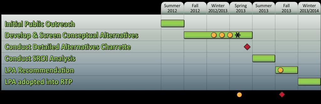
3 Project Connect CAMPO Centers Previous Studies/Plans Purpose & Need Congestion Growth Constraints Centers Travel Pattern/ Demand Analysis Transit Development Strategy Activity Density Index Implementation Strategies Conceptual Alternatives Alignments Modes/service options Coverage Centers served Design Charrette for Remaining Alternatives Alignments/modes/ service options Timing/phasing Centers and connecting land use structure Evaluation Criteria for Screening Initial Screening of Alternatives SROI Evaluation LPA 3
4 Discussed the redirected approach based on what we heard and learned Increased the focus on the transit and land use relationships Added the concept of timing for delivery of transit service over time Reviewed the Scoring Factors Reviewed and discussed the Alternatives Made revisions and took to PAG 4
5 Refinements were made to the Scoring Factors The Transit Development Strategy was enhanced Further work on land use/transit integration/phasing are underway New multi-modal Alternatives were developed 5
6 Provide long and short haul transit options at regional scale Provide multi-modal options Use MoPac managed lanes Caution on IH35 managed lanes dependence Do not preclude use if available 6
7 Provide east/west connections Connect more centers and identify multi-modal transit hubs Use MoKan Refine evaluation criteria Provide more interactive work time in meetings 7

8 North Corridor assessed within the regional context CAMPO s 4 C/G approach is the basis Centers Congestion Core Constraints Growth Added two new Factors to reflect the strategy Complexity Livability Used to screen from 6 alternatives to 2-3 for more detailed evaluation 8
9 Centers Number served by type Transit-supportive planning Capacity Congestion Core Estimated change in corridor congestion and vehicle hours traveled Linkage between centers to relieve congestion to Core Propensity to use transit Constraints Environmental suitability ROW needs Complexity Cost implications System efficiency/phases Intermodal connectivity Growth Estimated population changes Estimated employment changes New transit-supportive land use opportunities Transit-readiness for Center connectors Livability Potential to advance the six Livability Principles Added detail to the Factor based on Livability Principle sub-factors 9
10 10
11 Implementation Period Example Transit Level of Service Investment Example Transit Improvement Strategies (CMTA & Cities) Example Land Use/ Development Strategies (Cities) Phase 1 1 to 5 years Increase headways; add express service Add shelters and extend sidewalks; bus pull-outs Rezone around transit centers and major stops Phase 2 5 to 10 years Phase 3 10 to 20 years 11
12 Implementation Period Example Transit Level of Service Investment Example Transit Improvement Strategies (CMTA & Cities) Example Land Use/ Development Strategies (Cities) Phase 1 1 to 5 years Increase headways; add express service Add shelters and extend sidewalks; bus pull-outs Rezone around transit centers and major stops Phase 2 5 to 10 years Turn diamond lanes into exclusive transit/hov lanes Focus transit service on TOD locations Offer incentives or expedited permitting Phase 3 10 to 20 years 12
13 Implementation Period Example Transit Level of Service Investment Example Transit Improvement Strategies (CMTA & Cities) Example Land Use/ Development Strategies (Cities) Phase 1 1 to 5 years Increase headways; add express service Add shelters and extend sidewalks; bus pull-outs Rezone around transit centers and major stops Phase 2 5 to 10 years Turn diamond lanes into exclusive transit/hov lanes Focus transit service on TOD locations Offer incentives or expedited permitting Phase 3 10 to 20 years Construct rail in most suitable alignments with circulators Program station locations as system expands Set minimum development standards and use mix 13
 trains MetroRapid Plus -")


14 MetroRail - Commuter rail service similar to Capital Metro using Diesel Multiple Unit (DMU) trains MetroRapid Plus - Bus Rapid Transit (BRT) in dedicated fixed guideway operating similar to light rail, plus branding and high image stations MetroRapid - BRT on arterials operating in traffic with signal prioritization similar to Capital Metro s MetroRapid 14


15 MetroExpress - Long haul, limited service buses on major highways similar to the Capital Metro s MetroExpress commuter service MetroConnect - Short haul, limited service buses operating between major Centers generally on arterials 15
16 Major Routes IH35, SH45, MoPac Modes MetroRapid MetroExpress MetroConnect Capital Facilities Transit Hubs: Central Austin, Howard Lane, Pflugerville, Round Rock Park-and-Rides: Georgetown, Hutto, SH130/US290/Manor, SH130/SH71 16
17 Major Routes SH130, US290, MoKan, Freight Rail ROW, IH35, SH45, MoPac Modes MetroRapid MetroExpress MetroConnect Capital Facilities Transit Hubs: Central Austin, Howard Lane, Pflugerville, Round Rock Park-and-Rides: Georgetown, Hutto, SH130/US290/Manor, SH130/SH71 17
18 Major Routes SH130, FM685, MoKan, Freight Rail ROW, IH35, SH45, MoPac Modes MetroRapid MetroExpress MetroConnect Capital Facilities Transit Hubs: Central Austin, Howard Lane, Pflugerville, Round Rock Park-and-Rides: Georgetown, Hutto, SH130/US290/Manor, SH130/SH71 18

19 Major Routes SH130, FM1460, MoKan, Freight Rail ROW, IH35, SH45, MoPac Modes MetroRapid MetroExpress MetroConnect Capital Facilities Transit Hubs: Central Austin, Howard Lane, Pflugerville, Round Rock Park-and-Rides: Georgetown, Hutto, SH130/US290/Manor, SH130/SH71 19
20 Major Routes UP ROW, FM1460, IH35, SH45, MoPac Modes MetroRail (interlined with LSTAR) MetroRapid MetroExpress MetroConnect Capital Facilities Transit Hubs: Central Austin, Howard Lane, Pflugerville, Round Rock Park-and-Rides: Georgetown, Hutto, SH130/US290/Manor, SH130/SH71 20
21 Major Routes IH35, SH45, MoPac, MoKan, Freight Rail ROW Modes MetroRapid Plus MetroRapid MetroExpress MetroConnect Capital Facilities Transit Hubs: Central Austin, Howard Lane, Pflugerville, Round Rock Park-and-Rides: Georgetown, Hutto, SH130/US290/Manor, SH130/SH71 21
22 22
23 Service Features Local bus & shuttle operations at baseline levels (30 min peak) Service Type Persons + jobs/acre Index Local Transit 5-20 Development/ Density/patterns + mobility support 5-8 DU/A Limited mobility support Linkages between centers Limited Local bus at enhanced service level (15 min. peak) Arterial Transit Up to 20 DU/A Moderate mobility support Emerging Local bus & limited stop operations (10 min peak) Rapid Transit Up to 40 DU/A High mobility support Planned Local bus & LRT/BRT (5 min peak) High Capacity Transit 60+ > 40 DU/A High mobility support Committed 23

24 Land Use Components Existing and future land use Persons + jobs/acre index Density/use mix Patterns Readiness Mobility Components Transit service level Supporting/underlying transit service Pedestrian facilities Bicycle facilities 24
25 Areas that have or are planned to have transitsupportive qualities Concentrations of population and employment Compact and intensifying forms of development Streets supporting walking and biking Plans and policies promoting transit supportiveness Potential for future transit supportiveness Understand readiness across North Corridor and for each Alternative 25

26 Collect and evaluate corridor-wide datasets Land use and development data (CAMPO, CAD, CAPCOG) Centers datasets and research to further define Centers (CAMPO) Local plans and policies (Cities) Establish scoring methods Thresholds based on review of industry literature and calibrated to relate to local conditions Scoring using high-med-low scale in screening Evaluate alternatives Alternative scoring by measure (½ mile buffer) Alternative scoring by composite 26
27 Data used to assess supportiveness and readiness Dataset Notes Source Population, households and employment TAZ-Level for Employment 36ac cells for Population/HH CAMPO Land use existing and future 2012 and Composite FLU CADs/CAMPO/Cities Intensity and utilization 2012 Data re: Development CADs/CAPCOG Development pattern Intersection density GIS Sidewalks and bike lanes Existing facilities CAMPO Transit service Supporting Service CMTA Mobility priorities Pedestrian priority areas Bicycle priority corridors CAMPO 27


28 Maps for North Corridor and each Alternative AREA-WIDE MAP OF TRANSIT SUPPORTIVENESS CORRIDOR MAP OF SINGLE MEASURE 28

 Readiness is based land availability and local")
29 Analysis of supportiveness is related to local development types Current regional development types have transit supportive characteristics Compact Walkable Mixed use Dense (versus typical suburban patterns) Readiness is based land availability and local plans and policies 29


30 Suburban Neighborhood Less than 7 du/ac, 1-2 floors typical, Low density single family subdivision, 5,000 sf lots or greater Compact Neighborhood du/ac, 1-2 floors typical, Walkable urban, detached houses on lots less than 5,000 sf, town homes on lots less than 2,500 sf Compact Neighborhood du/ac, 2-3 floors typical, Surface parked, garden apartments, stacked flats Urban Neighborhood du/ac, 3-4 floors typical, wood frame construction, encapsulated or podium garage Urban Neighborhood du/ac, greater than 4 floors, high density, high rise, concrete and wood construction, typically in more urban locations 30


31 Low Intensity Suburban less than.25 FAR, strip commercial retail, low rise office, surface parked at 4 or more cars per 1,000 sf Mid Intensity Commercial.25 FAR-1.0 FAR, 1-3 stories, combination of surface and decked parking Higher Intensity Commercial Greater than 1.0 FAR, 4 stories or greater, mid-rise, garage parking in podium or separate structure, often in downtown or urban locations 31
32 32

33 TAC meeting February 13, Round Rock Chamber Board Room Project Connect open houses, week of February 17 PAG meeting - February 26, McConico Bldg Community Room, Round Rock TAC meeting - March, date and location TBD PAG meeting - March, date and location TBD Two public open houses Week of April 15, TBD Technical Design Charrette Week of May 20 33
34 Technical Advisory Committee Thank You! January 29,
3.0 REVIEW OF PREVIOUS STUDIES
 3.0 REVIEW OF PREVIOUS STUDIES This section of the highlights the significant features from previous plans and studies that could impact the development of the I-20 East Transit Initiative. Much of the
AMPO Annual Conference Session: Performance (Part 1) October 18, 2017 Savannah, GA
 October 18, 2017 Savannah, GA") AMPO Annual Conference Session: Performance (Part 1) October 18, 2017 Savannah, GA Introduction: North Jersey Transportation Planning Authority NJTPA Congestion Management Process Study Goals Analysis
AMPO Annual Conference Session: Performance (Part 1) October 18, 2017 Savannah, GA Introduction: North Jersey Transportation Planning Authority NJTPA Congestion Management Process Study Goals Analysis
2030 Transportation Policy Plan SUMMARY PRESENTATION. Land Use Advisory Committee November 15, 2012
 2030 Transportation Policy Plan SUMMARY PRESENTATION Land Use Advisory Committee November 15, 2012 Today s Topics Transportation Policy Plan (TPP) Requirements and Background Current TPP Policies, Issues
The Policies section will also provide guidance and short range policies in order to accomplish the goals and objectives.
 4 Goals & Objectives INTRODUCTION The 2015-2040 MTP preserves and promotes the quality of life and economic prosperity of the MAB by providing a transportation system consistent with the regional goals.
2040 Transportation Policy Plan Conversion to Performance Based Planning Basis. 25 th Annual CTS Transportation Research Conference May 21, 2014
 2040 Transportation Policy Plan Conversion to Performance Based Planning Basis 25 th Annual CTS Transportation Research Conference May 21, 2014 1 About the plan Long-range transportation plan for the Twin
KNOXVILLE REGIONAL TRANSIT CORRIDOR STUDY
 KNOXVILLE REGIONAL TRANSIT CORRIDOR STUDY April 2013 Alignments Alignments Magnolia Ave Northeast corridor Knoxville Transit Center Hall of Fame Dr Magnolia Ave Prosser Rd. Corridor contains commercial,
THE REGION S PLAN POLICY FRAMEWORK. August 2015
 THE REGION S PLAN POLICY FRAMEWORK August 2015 2 What is The Policy Framework? Cover photo credit: Sinan Sinharoy for Atlanta BeltLine, Inc. Atlanta is one of the world s most dynamic metropolitan areas,
Chapter 4: Transportation and Land Use
 Chapter 4: Transportation and Land Use Transportation and land use together make possible the wide range of destination opportunities in the region. Transportation provides the connections, and, in turn,
3. STATION SPACING AND SITING GUIDELINES
 3. STATION SPACING AND SITING GUIDELINES The station spacing and siting guidelines are summarized in Table 3-1. Table 3-1 also includes benchmark information for local transit service and express bus as
Fairfax County Countywide Transit Network Study
 Fairfax County Countywide Transit Network Study Proposed High Quality Transit Network Concept Metropolitan Washington Council of Governments Travel Forecasting Subcommittee September 20, 2013 1 Presentation
VEHICLES MILES TRAVELED (VMT) TRAFFIC IMPACT METRIC
 TRAFFIC IMPACT METRIC") VEHICLES MILES TRAVELED (VMT) TRAFFIC IMPACT METRIC A project-specific quantified analysis of the MGA Campus has been undertaken to compare BAU to the project including the project s VMT reduction program
VEHICLES MILES TRAVELED (VMT) TRAFFIC IMPACT METRIC A project-specific quantified analysis of the MGA Campus has been undertaken to compare BAU to the project including the project s VMT reduction program
TRANSIT SERVICE GUIDELINES
 CHATHAM AREA TRANSIT AUTHORITY FEBRUARY 2014 Table of Contents 1. PURPOSE... 3 2. CAT SERVICE GUIDELINES... 3 3. TRAVEL MARKETS... 4 4. TRANSIT COVERAGE... 4 5. TRANSIT ACCESS... 4 6. BUS STOP SPACING
CITY OF JACKSONVILLE 2030 MOBILITY PLAN STUDY UPDATE GOALS, OBJECTIVES, AND PERFORMANCE MEASURES PREPARED FOR: CITY OF JACKSONVILLE
 CITY OF JACKSONVILLE 2030 MOBILITY PLAN STUDY UPDATE GOALS, OBJECTIVES, AND PERFORMANCE MEASURES 3.20.2017 PREPARED FOR: CITY OF JACKSONVILLE 55 Railroad Row White River Junction, VT 05001 802.295.4999
ATTACHMENT A. Detailed Study Scope. I-66 (Inside) Multi-modal Study Scope
 Multi-modal Study Scope") ATTACHMENT A Detailed Study Scope I-66 (Inside) Multi-modal Study Scope EXECUTIVE SUMMARY The Virginia Department of Transportation (VDOT) seeks consultant assistance in identifying and evaluating a range
ATTACHMENT A Detailed Study Scope I-66 (Inside) Multi-modal Study Scope EXECUTIVE SUMMARY The Virginia Department of Transportation (VDOT) seeks consultant assistance in identifying and evaluating a range
Transit Service Guidelines
 G R E AT E R VA N CO U V E R T R A N S P O RTAT I O N A U T H O R I T Y Transit Service Guidelines PUBLIC SUMMARY REPORT JUNE 2004 Greater Vancouver Transportation Authority TRANSIT SERVICE GUIDELINES
SOUTHEAST FLORIDA REGIONAL COMPACT CLIMATE CHANGE. Sustainable Communities & Transportation Planning
 SOUTHEAST FLORIDA REGIONAL COMPACT CLIMATE CHANGE Draft Regional Climate Action Plan Sustainable Communities & Transportation Planning SP-1 Develop criteria in collaboration with municipal and county planning
South Sounder Capital Improvements Program
 South Sounder Capital Improvements Program Subarea South King/Pierce Primary Mode Commuter Rail Facility Type Infrastructure Improvement Length Version Draft ST3 Plan Date Last Modified March 28, 2016
S-09: Auburn Station Access Improvements
 Project Number S-09 Subarea South King Primary Mode Commuter Rail Facility Type Infrastructure Improvements Length Version Number ST Board Workshop Date Last Modified 11-25-2015 PROJECT AREA AND REPRESENTATIVE
Rapid Transit in Winnipeg. Winnipeg TOD Summit November 17, 2014
 Rapid Transit in Winnipeg Winnipeg TOD Summit November 17, 2014 Presentation Overview Rapid Transit (RT) in Winnipeg What is RT? What are our RT plans? Near term Longer term Comments re: TOD OurWinnipeg
From Policy to Reality
 From Policy to Reality Updated ^ Model Ordinances for Sustainable Development 2000 Environmental Quality Board 2008 Minnesota Pollution Control Agency Funded by a Minnesota Pollution Control Agency Sustainable
Congestion Management Process 2013 Update
 OVERVIEW OF THE DALLAS-FORT WORTH CONGESTION MANAGEMENT PROCESS Traffic Congestion In The Dallas-Fort Worth Region With the Dallas-Fort Worth (DFW) urban area as its center, the North Central Texas region
1.1.1.b. Agencies share best practices as they integrate COMPASS facilitates
 Transportation Goals 1.1 Enhance the system to improve accessibility and connectivity to jobs, schools, and services; allow the efficient movement of people and goods; and ensure the reliability of travel
SERVICE IMPROVEMENT STRATEGIES AND SCENARIOS
 SERVICE IMPROVEMENT STRATEGIES AND SCENARIOS The Hartford region has seen significant improvements in terms of intermodal connectivity and mode choice. Recent investments include the new CTfastrak bus
Transit Oriented Development Study
 Federal Way Link Extension Transit Oriented Development Study Table of Contents Executive Summary ES 1 Chapter 1: Introduction.. 1-1 Chapter 2: Methodology. 2-1 Chapter 3: Project Overview 3-1 Chapter
PINELLAS COUNTY MOBILITY PLAN SUMMARY REPORT
 PINELLAS COUNTY MOBILITY PLAN SUMMARY REPORT In September, 2013, the Pinellas County Mobility Plan Report was approved by the Metropolitan Planning Organization (MPO). This action endorsed a countywide
1 RICHMOND HILL CENTRE / LANGSTAFF URBAN GROWTH CENTRE - TRANSPORTATION STUDY
 Report No. 4 of the Transportation Services Committee Regional Council Meeting of April 22, 2010 1 RICHMOND HILL CENTRE / LANGSTAFF URBAN GROWTH CENTRE - TRANSPORTATION STUDY The Transportation Services
TRANSPORTATION MOBILITY PLAN GUIDELINES
 TRANSPORTATION MOBILITY PLAN GUIDELINES for Development Applications November 2016 Executive Summary The Regional Municipality of York (the Region) is located in the heart of the Greater Toronto Area (GTA)
Appendix D: Functional Classification Criteria and Characteristics, and MnDOT Access Guidance
 APPENDICES Appendix D: Functional Classification Criteria and Characteristics, and MnDOT Access Guidance D.1 Functional classification identifies the role a highway or street plays in the transportation
SPACE COAST TRANSPORTATION PLANNING ORGANIZATION
 SPACE COAST TRANSPORTATION PLANNING ORGANIZATION DRAFT AUGUST 2015 This page intentionally left blank SPACE COAST TRANSPORTATION PLANNING ORGANIZATION DRAFT AUGUST 2015 prepared by: This page intentionally
Miami-Dade Transit. Alice N. Bravo, P.E. Director. Miami-Dade Transit 1
 Miami-Dade Transit Alice N. Bravo, P.E. Director Miami-Dade Transit 1 Miami-Dade Transit MDT is the largest transit agency in the State of Florida, and one of the largest departments within Miami-Dade
1.1 Purpose of the Project
 Chapter 1 Purpose and Need for East Link Project 1.1 Purpose of the Project The purpose of the East Link Project is to expand the Sound Transit Link light rail system from Seattle to Mercer Island, Bellevue
Chapter 10 Goals, Objectives + Policies
 Chapter 10 Goals, + Policies Warehouse on Nestle Way near I-78 114 115 10.1 ESTABLISHMENT OF CONSISTENT GOALS 10.2 NATIONAL FREIGHT GOALS The Lehigh Valley s freight transportation investment decisions
Central Phoenix Transportation Framework Study
 Central Phoenix Transportation Framework Study Study Area 2013, All Rights Reserved. 1 Agenda Introductions Work Products Feedback on previous products Draft products for Planning Partner review SR-30
AIR QUALITY AND CLIMATE CHANGE EVALUATION GUIDANCE
 AIR QUALITY AND CLIMATE CHANGE EVALUATION GUIDANCE The following guidance provides additional details regarding the process followed by PSRC to evaluate projects for potential air quality benefits. As
FINAL. Technical Memorandum #2: Alternative Scenarios Performance Report
 General Planning Consultant Services RFP P5413 Contract No. 200703566 Work Order No. 2009-01 / Task 2-3 FINAL S O U T H F U LTO N PA R K W AY T R A N S I T F E A S I B I L I T Y S T U DY Technical Memorandum
MEMORANDUM EXAMPLES FOR ILLUSTRATIVE PURPOSES NEXT STEPS. Item 3 Long-Range Plan Task Force May 17, 2017
 Item 3 Long-Range Plan Task Force May 17, 2017 MEMORANDUM TO: TPB Long-Range Plan Task Force FROM: Kanti Srikanth, TPB Staff Director SUBJECT: Sample list of improvement initiatives for illustrative purposes
METRA UP-W LINE. Locally Preferred Alternative Report
 METRA UP-W LINE Cook, Kane, and DuPage Counties Illinois Alternatives Analysis Study Document #9 Locally Preferred Alternative Report August 13, 2007 Prepared by Parsons Alternatives Analysis Documents
I-710 Project Committee Meeting
 Los Angeles County Metropolitan Transportation Authority I-710 Project Committee Meeting January 29, 2009 Meeting Expectations Review I-710 planning context Concur on a port cargo forecast scenario to
Project Evaluation Criteria
 Project Evaluation Criteria Goals and Objectives were developed to guide Envision 35 Long Range Transportation Plan (LRTP) Update. These guiding principles were based on the requirements included in the
Project Initiation Form
 Meeting Date: The Project Initiation Form should be completed in conjunction with the Level 2 Screening Form. Process Leads and/or Planners should complete the Project Initiation Form to document coordination
RURAL RESIDENTIAL COMMUNITY ROLE COUNCIL ROLE RURAL RESIDENTIAL ALL COMMUNITIES
 Orderly and Efficient Land Use Align land use, development patterns, and infrastructure to make the best use of public and private investment. Discourage future development of rural residential patterns
FUTURE BUS RAPID TRANSIT PLANS
 ATTACHMENT 1 Preferred Configuration Saskatoon Bus Rapid Transit - Preferred Configuration FUTURE BUS RAPID TRANSIT PLANS Plan For Growth Transportation Plan BRT Plan October 2017 saskatoon.ca/engage 1
LAND USE POLICIES BY COMMUNITY DESIGNATION
 137 2040 138 Land Use Policies by Community Designation As discussed earlier in Thrive MSP 2040, the Council assigns a community designation to each city and township. This designation indicates the overall
THAT Council adopt the Congestion Management Strategy as outlined in this report
 RR3 ADMINISTRATIVE REPORT Report Date: May 2, 2017 Contact: Winston Chou Contact No.: 604.873.7913 RTS No.: 011564 VanRIMS No.: 08200020 Meeting Date: May 16, 2017 TO: FROM: SUBJECT: Vancouver City Council
Clifton Corridor Transit Initiative Project Development and NEPA. New Starts Assessment
 Clifton Corridor Transit Initiative Project Development and NEPA Phase 1 Environmental Review and Alternative Refinement Prepared for: Metropolitan Atlanta Rapid Transit Authority Prepared by: AECOM/JACOBS-JJG
APPENDIX A WILLIAMSON COUNTY PUBLIC TRANSPORTATION COORDINATION ISSUES BRIEFING PAPER
 APPENDIX A WILLIAMSON COUNTY PUBLIC TRANSPORTATION COORDINATION ISSUES BRIEFING PAPER APPENDIX A WILLIAMSON COUNTY PUBLIC TRANSPORTATION COORDINATION ISSUES BRIEFING PAPER INTRODUCTION The Capital Area
This page intentionally left blank.
 EXECUTIVE SUMMARY This page intentionally left blank. SATOMORROW MULTIMODAL TRANSPORTATION PLAN EXECUTIVE SUMMARY Introduction The City of San Antonio is anticipated to experience tremendous growth resulting
Effective Transportation Demand Management (TDM) in Congested Corridors US 422 TDM Best Practices Policy Brief and Recommendations
 in Congested Corridors US 422 TDM Best Practices Policy Brief and Recommendations") Effective Transportation Demand Management (TDM) in Congested Corridors US 422 TDM Best Practices Policy Brief and Recommendations Pennsylvania Chapter of the American Planning Association Annual Conference
Effective Transportation Demand Management (TDM) in Congested Corridors US 422 TDM Best Practices Policy Brief and Recommendations Pennsylvania Chapter of the American Planning Association Annual Conference
MONITORING IMPLEMENTATION AND PERFORMANCE
 12 MONITORING IMPLEMENTATION AND PERFORMANCE The FAST Act continues the legislation authorized under MAP-21, which created a data-driven, performance-based multimodal program to address the many challenges
Mission Capital Metro connects people, jobs and communities by providing high quality and sustainable transportation choices.
 October 20, 2011 Dear Capital Metro Board of Directors: I am pleased to present a copy of Capital Metro s strategic plan for Fiscal Year 2012. As you know, we began this process with a board retreat in
NEW OPPORTUNITY FOR MIDDLESEX COUNTY
 Source: http://www.flickr.com/photos/scraparcs/3259040067/sizes/l/in/photostream/ RARITAN RIVER LIGHT RAIL NEW OPPORTUNITY FOR MIDDLESEX COUNTY This report studies the viability of a new transit line connecting
URBAN CENTER COMMUNITY ROLE COUNCIL ROLE ALL COMMUNITIES URBAN CENTER
 Orderly and Efficient Land Use Align land use, development patterns, and infrastructure to make the best use of public and private investment. Plan for forecasted population and household growth at average
Building the Regional Transit Strategy
 oregonmetro.gov/rtp 2018 Regional Transportation Plan Building the Regional Transit Strategy TriMet Board of Directors August 9, 2017 Regional Transportation Plan Sets the course for moving the region
Scope of Work. Project Approach and Understanding. Task 1: Study Initiation and Administration
 Scope of Work Route 116/Hinesburg Growth Center Corridor Study Town of Hinesburg and CCRPC Project Approach and Understanding Route 116 through Hinesburg had seen substantial changes in the past 15 years,
HORIZON 2030: Plan Projects November 2005
 Horizon PROJECTS 2030 Projects 10-1 10-2 The Horizon 2030 Project Information section is comprised of individual project information in alphabetical order by project name. The information provided for
Subarea Mobility Enhancements. 5.1 Transit and Pedestrian Improvements
 Section Five Section 5: Subarea Mobility Enhancements 5.1 Transit and Pedestrian Improvements From the outset of the master planning process, one of the primary goals was to integrate transit and pedestrian-oriented
Long-Range Plan Task Force: Draft Analysis Results
 Long-Range Plan Task Force: Draft Analysis Results November 15, 2017 Prepared for: National Capital Region Transportation Planning Board Transportation Planning Board Item #9 Presentation Components Analysis
PROTECTING Our Quality of Life... Why the Capital Region Needs to Invest in Mass Transit NOW
 PROTECTING Our Quality of Life... Why the Capital Region Needs to Invest in Mass Transit NOW The Challenge... Traffic congestion in the Capital Region has doubled over the last decade. $86M Total cost
Executive Summary October 2017
 Executive Summary The King of Prussia Rail Draft Environmental Impact Statement/Draft Section 4(f) Evaluation (DEIS) describes and summarizes the transportation and environmental benefits and impacts of
David King, Railway Procurement Agency 14 th November 2012
 Bus Rapid Transit for Dublin Hugh Creegan, National Transport Authority David King, Railway Procurement Agency 14 th November 2012 Topics Core Dublin BRT Network System Concept BRT in the Transport System
San Francisco Freeway Corridor Management Study (SF FCMS)
") Item 6 Enclosure B Plans and Programs Committee March 17, 2015 San Francisco Freeway Corridor Management Study (SF FCMS) Phase 1 Findings and Recommendations Agenda Item 6 SAN FRANCISCO COUNTY TRANSPORTATION
Item 6 Enclosure B Plans and Programs Committee March 17, 2015 San Francisco Freeway Corridor Management Study (SF FCMS) Phase 1 Findings and Recommendations Agenda Item 6 SAN FRANCISCO COUNTY TRANSPORTATION
Preliminary Look. CRTC Annual Meeting January 16, 2018
 Preliminary Look CRTC Annual Meeting January 16, 2018 Building off of One Region Forward Regional Voices 2050 Plan Intent Develop and modernize a transportation system for the region over the next three
Category 3, BART Capacity, Access and Parking Improvements. Contra Costa Transportation Authority STAFF REPORT Page 2 of 5 The Authority directed staf
 Meeting Date: Subject Summary of Issues Recommendations Financial Implications Options Attachments Changes from Committee Development of a Potential Transportation Expenditure Plan (TEP) Review and Discussion
Blacklands Corridor Feasibility Study
 Blacklands Corridor Feasibility Study Public Meeting May 13, 2014 The Atrium at the Granville Arts Center 300 N. Fifth Street, Garland, Texas 1 Overview Welcome and Public Involvement Efforts Amanda Wilson
Integrating Frequent Transit Service & Corridor-based Transit Supportive Environments in the Metro Vancouver Region. July 2009
 South Coast British Columbia Transportation Authority Integrating Frequent Transit Service & Corridor-based Transit Supportive Environments in the Metro Vancouver Region July 2009 By: Lyle Walker, Transportation
Future System Planning (ST4)
") Future System Planning (ST4) Subarea All Primary Mode Policies and Programs Facility Type Length Version Draft ST3 Plan Date Last Modified March 28, 2016 PROJECT AREA AND REPRESENTATIVE ALIGNMENT SHORT
Future System Planning (ST4) Subarea All Primary Mode Policies and Programs Facility Type Length Version Draft ST3 Plan Date Last Modified March 28, 2016 PROJECT AREA AND REPRESENTATIVE ALIGNMENT SHORT
Transit Oriented Development Strategic Plan for Bhopal
 Transit Oriented Development Strategic Plan for Bhopal 26 th February, 2015 IBI GROUP INTRODUCING BHOPAL Transport Urban Form Policy Framework Bhopal Curitiba Bhopal Curitiba Ottawa Population 1.79 million
VISION. 4. Vision. 31 Page
 VISION 4. Vision The 2035 LRTP, branded as Transformation, is the Broward MPO s plan for change. Economic vitality for the region, a better environment, and enhanced quality of life are envisioned. This
Sounder Extension to DuPont
 Subarea Pierce Primary Mode Commuter Rail Facility Type Station Length 7.8 miles Version Draft ST3 Plan Date Last Modified March 28, 2016 PROJECT AREA AND REPRESENTATIVE ALIGNMENT SHORT PROJECT DESCRIPTION
Houston Galveston Area Council Congestion Management Process
 Houston Galveston Area Council Congestion Management Process APPENDIX G of the 2035 Regional Transportation Plan Update Prepared for: Houston-Galveston Area Council Transportation Department 3555 Timmons
- FACT SHEET - THE GUIDING PRINCIPLES
 THE GUIDING PRINCIPLES The General Plan begins with seven ideas that together create a vision for the City s future. When the City approved the General Plan in 1994, these idea were dubbed the Seven Guiding
GUIDING PRINCIPLES MEMORANDUM
 M E T R O P O L I TAN TRA NS P O RTATI O N PLAN GUIDING PRINCIPLES MEMORANDUM El Paso Metropolitan Planning Organization INTRODUCTION The guiding principles for development of the El Paso MPO s Destino
CHAPTER IV REQUIREMENTS AND GUIDELINES FOR FIXED ROUTE TRANSIT PROVIDERS
 Chap. IV-1 CHAPTER IV REQUIREMENTS AND GUIDELINES FOR FIXED ROUTE TRANSIT PROVIDERS 1. INTRODUCTION. The requirements described in this chapter apply to all providers of fixed route public transportation
High-Speed Rail - Chicago to St. Louis Alton Regional Multimodal Transportation Center Project
 High-Speed Rail - Chicago to St. Louis Alton Regional Multimodal May 2012 Draft Report: Alternatives Screening Version 1.0 1.0 Introduction This document outlines the alternatives screening process used
PLAN 2040 Regional Transportation Plan Update. Final Recommendations. Transportation and Air Quality Committee March 13, 2014
 PLAN 2040 Regional Transportation Plan Update Final Recommendations Transportation and Air Quality Committee March 13, 2014 TIP/RTP Update Milestones Official public comment period closed February 21 Final
MULTIMODAL TRANSPORTATION IMPACT STUDY GUIDELINES
 MULTIMODAL TRANSPORTATION IMPACT STUDY GUIDELINES 1 st Edition City of San Luis Obispo 2035 Circulation Element 1 Table of Contents Introduction... 2 Process... 2 When Impact Studies Are Required... 3
COMPREHENSIVE TRANSPORTATION REVIEW THE WHARF PHASE 2 PUD
 COMPREHENSIVE TRANSPORTATION REVIEW THE WHARF PHASE 2 PUD WASHINGTON, DC September 18, 2017 Prepared by: 1140 Connecticut Avenue NW Suite 600 Washington, DC 20036 Tel: 202.296.8625 Fax: 202.785.1276 3914
Envisioning the Future: A History of Regional Planning Initiatives, Studies, and Plans
 Express Commuter Transit Travel Demand Management Regional Vanpool Program Regional Transportation Planning Piedmont Triad Regional Model Training and Education Convening and Cooperation Envisioning the
Management and Integration of Data and Modeling at Santa Clara County Congestion Management Agency
 Management and Integration of Data and Modeling at Santa Clara County Congestion Management Agency VTA Modeling and GIS Group Peter Chen ITE SF Bay Area Annual Modeling Workshop April 29, 2015 Outlines
Funding Intelligent Transportation Systems in the Los Angeles Region
 Funding Intelligent Transportation Systems in the Los Angeles Region 2017 ITS California Annual Meeting Ed Alegre, PTP Los Angeles County Metropolitan Transportation Authority (Metro) Los Angeles Region
2. What is the genesis of the KOP Rail project? How long has this been studied?
 These frequently asked questions (FAQ) have been developed to help residents, businesses and area stakeholders develop a better understanding of the proposed King of Prussia Rail Project, the project development
North Side Transfer Zone. Public Open House April 16, 2014
 North Side Transfer Zone Public Open House Agenda Introductions Project Background and Purpose Transit Zone Components Site Identification Concepts Open Discussion 2 Project Purpose To determine the feasibility
Amman Transportation Strategy
 Amman Transportation Strategy from Planning to Implementation Ayman Smadi Regional Conference on Sustainable Urban Transport Damascus (Syria), April 11-13, 2010 Outline Background and introduction Current
South Boston. Transportation Plan. Transportation Planning Division. Virginia Department of Transportation
 2020 Transportation Plan Developed by the Transportation Planning Division of the Virginia Department of Transportation in cooperation with the U.S. Department of Transportation, Federal Highway Administration
LOCALLY PREFERRED ALTERNATIVE REPORT
 SOUTHEAST CORRIDOR ALTERNATIVES ANALYSIS DOCUMENT #9 LOCALLY PREFERRED ALTERNATIVE REPORT PREPARED BY AUGUST 2011 ALTERNATIVES ANALYSIS DOCUMENTS 1. Detailed Work Scope 2. Purpose & Need 3. Initial Alternatives,
Integrating Intermodalism and Multimodalism
 Forest Hills Gardens, NY, station area, c.1916 Working Definitions Multimodal means multiple modes of transportation. Multimodal systems enhance capacity across modes. Linden Hills neighborhood, Mpls.
Complementary Measures: State and Regional Efforts to Reduce Emissions from the Transportation Sector
 Complementary Measures: State and Regional Efforts to Reduce Emissions from the Transportation Sector September 25, 2012 Sonia Hamel Climate and Energy Consultant Why Transportation Matters U.S. Transportation
Calgary Transportation Plan. Adopted by Council September calgary.ca call 3-1-1
 Calgary Transportation Plan Adopted by Council September 2009 calgary.ca call 3-1-1 Document Updates: Date Report Description 2012 January 10 C2012-03 Delete and replace Maps 1, 2, 5, 6 and 7 to relfect
Staff Priority and UPWP Committee Priority List 3/25/2016. ID Proposed Study Name Project Category Tentative Project Cost
 Staff and UPWP Committee List 3/25/2016 Projects with Only (No Bottom Non- ) C-2 Safety and Operations at Selected Intersections: FFY 2017 Roadway Network Performance $65,000 Purpose: The purpose of this
STATEWIDE ANALYSIS MODEL (SAM-V3) June 5, 2014 Janie Temple
 June 5, 2014 Janie Temple") STATEWIDE ANALYSIS MODEL (SAM-V3) June 5, 2014 Janie Temple Introduction Brief SAM History Intro to SAM-V3 functionality Past and Current SAM projects Future additions to SAM Suggestions from model users
STATEWIDE ANALYSIS MODEL (SAM-V3) June 5, 2014 Janie Temple Introduction Brief SAM History Intro to SAM-V3 functionality Past and Current SAM projects Future additions to SAM Suggestions from model users
Transportation Concurrency
 2015 Frequently Asked Questions About. Transportation Concurrency Q. What is Transportation Concurrency? A. Transportation Concurrency is both a State law requirement and a City pre-application development
September Public Meetings. Developing a Blueprint for the Corridor
 September Public Meetings Developing a Blueprint for the Corridor Study Background Study initiated by the Commonwealth Transportation Board (CTB) and administered by VDOT in association with VDRPT. Addresses
Chapter 8. Transportation Element
 Chapter 8. Transportation Element Introduction/Overview Element Requirements Transportation is a key issue and priority in Longview. State highways, local roads, transit, railroads, and the port are lifelines
Mobility and System Reliability Goal
 Mobility and System Reliability Goal Provide surface transportation infrastructure and services that will advance the efficient and reliable movement of people and goods throughout the state. Background:
Alternatives Analysis Executive Summary
 Durham-Orange County Corridor APRIL 2012 Prepared for: TriangleTransit Prepared by: URS Team Executive Summary Introduction The 2035 Long Range Transportation Plan, jointly adopted by the Durham Chapel
CAPITAL AREA TRANSIT PLANNING SERVICE STANDARDS AND PROCESS. Planning Department
 CAPITAL AREA TRANSIT PLANNING SERVICE STANDARDS AND PROCESS Planning Department January 2016 INTRODUCTION Transit Service Standards are public rules and guidelines used to make decisions about where transit
Chapter 4: Developing the Recommendations
 Virginia s continued investment in its transportation system is vital to the safe and efficient movement of people and goods and to the entire Commonwealth s economic wellbeing. Every element of Virginia
TCATS October 12-Michigan Works 5:30-7pm. NATS October 19-Niles District Library 6-7:30pm
 Goal Development Workshop TCATS October 12- Works 5:30-7pm NATS October 19-Niles District Library 6-7:30pm SAFETEA-LU Goals 2035 TwinCATS Goals 2030 TwinCATS Goals 1. Support the economic vitality of the
Regional Transportation Studies Regional Council
 Pima Association of Governments 1 E. Broadway, Tucson, Arizona Santa Rita Conference Room Regional Transportation Studies Regional Council September 28, 2017 I-11 Tier 1 Environmental Impact Statement
A long-term, comprehensive solution
 A long-term, comprehensive solution Nancy Boyd CRC Project Director for Washington Portland State University Transportation Seminar April 15 2011 Frank Green April 15, 2011 CRC Structural Engineering Manager