Developing Big-Data Infrastructure for Analyzing AIS Vessel Tracking Data on a Global Scale
|
|
|
- Buddy Briggs
- 6 years ago
- Views:
Transcription

1 Ocean Science Meeting 2018 Big Data for a Big Ocean: Progress on Tools, Technology, and Services III Developing Big-Data Infrastructure for Analyzing AIS Vessel Tracking Data on a Global Scale Jessica Austin Axiom Data Science 02/15/2018
2 The Automatic Identification System (AIS) " On-board tracking system, transmitting over VHF AIS equipment integrates with vessel navigation systems, such as GPS Other AIS-equipped ships can see traffic in the area Land-based (and satellite) receiver networks can collect data for an entire region " Increasing interest in analyzing historic datasets Prioritizing hydrographic surveys Predicting probability and impact of oil spills Quantifying interaction with marine wildlife etc 2
3 Project Overview Problem: Due to immense size of these datasets typically 10s of billions of raw messages per year and limitations on infrastructure and computing power, AIS data must currently be processed in small temporal or spatial subsets. Solution: Develop cluster computing infrastructure and applications to analyze the data across many machines in parallel Results: Previous workflow: single machine, small subset days to weeks weeks to process Our workflow: compute cluster, all US waters for one year 48 hours 3

4 What is Cluster Computing? Technologies 16 computers 368 total cores 1500 GB available memory 4
5 The Data Processing Pipeline Raw AIS Messages Vessel Pings Daily Vessel Filtered Vessel Vessel Traffic Heatmaps 5
6 Real-world example: Hydrographic Health Model " Hydrographic Health Model establishes survey priorities across all US waters Managed by NOAA Office of Coast Survey (OCS) Includes metrics like: When was this area last surveyed? What is the seafloor complexity? What is the typical vessel traffic in this area? etc " Vessel Traffic Heatmap requirements We only care about ships that are moving and that are in US waters Need to be split out by ship type, metric, and region (30 total files) Tanker, Cargo, Passenger, and Other, and All ships Total Vessel Count and Unique Vessel Count Continental US, Alaska, Hawaii 500m resolution, Albers Equal Area projection " Current state-of-the-art (an ArcMap plugin) takes days to weeks to process small spatio-temporal subset of data 6
7 Pipeline: Raw AIS messages " AIS Messages are collected by land-based and satellite receivers Agencies aggregate messages, and provide them as a database Each message includes: timestamp, ship MMSI, latitude, longitude, speed over ground, etc " Vessel Catalog Maps MMSI to vessel attributes Ship type, max draft, length, etc " Possible issues Duplicate data Limited range for land-based Self-reported data Raw AIS Messages Vessel Pings Daily Vessel Filtered Vessel Vessel Traffic Heatmaps 7
8 Pipeline: Raw AIS messages " AIS Messages are collected by land-based and satellite receivers Agencies aggregate messages, and provide them as a database Each message includes: timestamp, ship MMSI, latitude, longitude, speed over ground, etc " Vessel Catalog Maps MMSI to vessel attributes Ship type, max draft, length, etc " Possible issues Duplicate data Limited range for land-based Self-reported data Real-world Example: Hydrographic Health Model 2015 Terrestrial data from Coast Guard network (via NOAA OCS) 74,212,891,806 messages (7.5TB uncompressed) Vessel Catalog: From US Coast Guard, 80,855 vessels Raw AIS Messages Vessel Pings Daily Vessel Filtered Vessel Vessel Traffic Heatmaps 8
9 Pipeline: Raw messages to Vessel Pings " Parse and clean the messages Discard invalid messages Discard any messages that are not Position Reports Remove duplicate messages " Result is called a Vessel Ping Real-world Example: Hydrographic Health Model Input: 74,212,891,806 raw messages Output: 2,017,535,550 pings (2.72% of raw messages) Total time: 40.7 hrs (~6.7 min/day) Raw AIS Messages Vessel Pings Daily Vessel Filtered Vessel Vessel Traffic Heatmaps 9

10 Pipeline: Vessel Pings to Vessel " Vessel describe the probable path of a ship " are At least two pings long Broken up if the points are too sparse Broken up if the ship stopped in one place for a long time Raw AIS Messages Vessel Pings Daily Vessel Filtered Vessel Vessel Traffic Heatmaps 10
11 Pipeline: Vessel Pings to Vessel " Vessel describe the probable path of a ship " are At least two pings long Broken up if the points are too sparse Broken up if the ship stopped in one place Real-world Example: Hydrographic Health Model Input: 2,017,535,550 pings Output: 12,297,024 voyages Avg length: 51 pings (~31% of pings used) Total time: 3.2 hrs (~31 sec/day) Raw AIS Messages Vessel Pings Daily Vessel Filtered Vessel Vessel Traffic Heatmaps 11
12 Pipeline: Filtered Vessel " Join to Vessel Catalog by ship identifier (MMSI) " Segment data by Region Ship Type Time Frame etc Real-world Example: Hydrographic Health Model 30 total files: Regions: Continental US, Alaska, Hawaii Ship Types: Tanker, Cargo, Passenger, and Other, and All ships Metrics: Total Vessel Count and Unique Vessel Count Raw AIS Messages Vessel Pings Daily Vessel Filtered Vessel Vessel Traffic Heatmaps 12

13 Pipeline: Vessel Traffic Heatmaps " Divide region into a grid, then count crossings " Heatmap format is configurable GeoTIFF or NetCDF Arbitrary grid size; default is 500 meters Choice of Albers Equal Area projection " Possible metrics Total traffic volume Unique vessel count Maximum vessel draft etc... Raw AIS Messages Vessel Pings Daily Vessel Filtered Vessel Vessel Traffic Heatmaps 13
14 Pipeline: Vessel Traffic Heatmaps " Divide region into a grid, then count crossings " Heatmap format is configurable GeoTIFF or NetCDF Arbitrary grid size; default is 500 meters Choice of Albers Equal Area projection " Possible metrics Total traffic volume Unique vessel count Maximum vessel draft etc... Real-world Example: Hydrographic Health Model Input: 12,297,024 voyages Output: 30 heatmap files Total time: 90 minutes (Includes filtering and creating heatmaps) OVERALL TIME: 45.4 hrs Raw AIS Messages Vessel Pings Daily Vessel Filtered Vessel Vessel Traffic Heatmaps 14

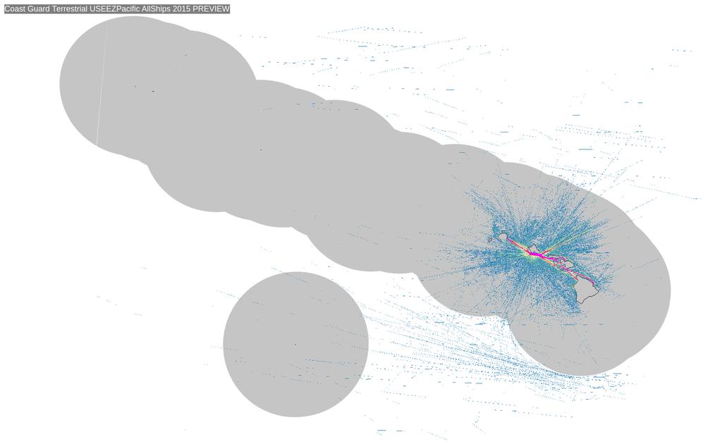
15 Real-world example: Hydrographic Health Model 15

16 Real-world example: Hydrographic Health Model Passenge r Anchorage Valdez Dutch Harbor Cargo Valdez Juneau Valdez Juneau Tanker Dutch Harbor Anchorage Dutch Harbor Anchorage Juneau Valdez Anchorage Juneau Dutch Harbor Other 16
17 What's Next? " Publicly available website with static downloads: " More datasets (currently in analysis): Marine Exchange of Alaska, Satellite AIS Data (global) Danish Maritime Authority (Europe) " Integration into IOOS and AOOS Data Portals View alongside sea ice models, environmental sensors, wildlife habitat datasets, etc Dataset added to IOOS Data Catalog, archived with NCEI " Enable ad-hoc querying with GeoTrellis, Jupyter Notebooks 17

 and")

18 Real-world example: Hydrographic Health Model Tanker Ships Passenger (blue) and Other (green) Total vs Unique Traffic: 18
Anomaly Detection in Vessel Tracking Using Support Vector Machines (SVMs)
") 2013 International Conference on Advanced Computer Science Applications and Technologies Anomaly Detection in Vessel Tracking Using Support Vector Machines (SVMs) Dini Oktarina Dwi Handayani 1, Wahju Sediono
2013 International Conference on Advanced Computer Science Applications and Technologies Anomaly Detection in Vessel Tracking Using Support Vector Machines (SVMs) Dini Oktarina Dwi Handayani 1, Wahju Sediono
ERDC and e-nav Data Use
 ERDC and e-nav Data Use Ned Mitchell, PhD Research Civil Engineer ERDC Coastal and Hydraulics Lab Vicksburg, Miss. AAPA Harbors and Navigation 30 MAR 2016 Traditional ERDC Harbors and Navigation Support
AIS Antenna Network Partnerships. Become part of our global expansion programme
 AIS Antenna Network Partnerships Become part of our global expansion programme Partner with the market leader in maritime and trade solutions Get connected to IHS Markit's professional global AIS network
Coastal and Marine Third Party
 Coastal and Marine Third Party Damage Incident DATA The data below was compiled from PHMSA, Minerals Management Service, United States Coast Guard and the National Transportation Safety Board. Description
Asset Monitoring Intelligence Center (AMIC)
") Global Data Solutions (GDS) PortVision PRESENTATION 360 - Asset TITLE Protection HERE & Asset Monitoring Intelligence Center (AMIC) Association of Petroleum Surveying & Geomatics APSG 38: Fall 2017 Meeting
Global Data Solutions (GDS) PortVision PRESENTATION 360 - Asset TITLE Protection HERE & Asset Monitoring Intelligence Center (AMIC) Association of Petroleum Surveying & Geomatics APSG 38: Fall 2017 Meeting
Alaska Deep-Draft Arctic Ports Navigation Feasibility Study. U.S. Army Corps of Engineers Bruce Sexauer P.E. Chief of Planning, Alaska District
 Alaska Deep-Draft Arctic Ports Navigation Feasibility Study U.S. Army Corps of Engineers Bruce Sexauer P.E. Chief of Planning, Alaska District Alaska Deep Draft Arctic Port System Study Purpose To identify
Marine Mobile Service Identifiers
 Draft Proposal on Marine Mobile Service Identifiers page 1 of 5 Marine Mobile Service Identifiers 1. Since 2000 AIS equipment has been applied onboard inland navigation vessels, and the onshore Vessel
Marine Board Spring Meeting April 27, 2011 David M. Kennedy
 Marine Board Spring Meeting April 27, 2011 David M. Kennedy NOS Organization 2 NOAA Next Generation Strategic Plan National Ocean Policy and Coastal Goal NOAA s Coastal Goal Objectives Resilient coastal
Data supply chain certification - quality monitoring and indication for e-navigation solution reliability
 Data supply chain certification - quality monitoring and indication for e-navigation solution reliability Michael Bergmann MBA AFNI AFRIN Director Maritime Industry President Supported by Evelin Engler
MTS Resilience: enavigation Best Practices
 MTS Resilience: enavigation Best Practices Transforming the Marine Transportation System: A Vision for R&D TRB Conference 2C Panel: Safety and Security Bahar Barami, Ph.D. Senior Economist Volpe Center,
Priority Setting Process For Hydrographic Surveys Page 1 of Parameter 1 - Quality of Survey Data Currently Available... 9
 Priority Setting Process For Hydrographic Surveys Page 1 of 25 Contents 1 Scope... 4 2 Related Standards... 4 Symbols (& Abbreviated Terms)... 5 4 Prioritising Parameters... 6 5 Weighting... 7 6 Issuing
DETAILED COURSE AGENDA
 DETAILED COURSE AGENDA Dynamics 365 University: Boot Camp Detailed Agenda Course Level: 100 This instructor-led course provides a key step for Microsoft Dynamics 365 administrators and customizers who
e-navigation workshop
 e-navigation workshop EU initiatives related to the integration of the maritime information systems 1 17 and 18 October 2012 Haugesund, Norway Lazaros Aichmalotidis Head of Unit C.2 Vessel traffic and
STAD SHIP TUNNEL. Fire Protection & Safety in Tunnels conference Terje Andreassen, Project Manager. Vi tar ansvar for sjøvegen
 STAD SHIP TUNNEL Fire Protection & Safety in Tunnels conference 2017 Terje Andreassen, Project Manager Bergen, 20. September 2017 Increased Safety and Improved Navigation for Maritime Transport past Stad
Maritime Intelligence Risk Suite
 IHS MARITIME & TRADE Maritime Intelligence Risk Suite Whatever your risk... Whatever your risk... Identifying and evaluating maritime risk is a challenging business for marine insurers, finance, ship owners,
Project Overview. Northwest Innovation Works LLC and the Port of Kalama propose to develop and operate
 Project Overview Northwest Innovation Works LLC and the Port of Kalama propose to develop and operate a natural gas-tomethanol production plant and storage facilities, and a new marine terminal, in the
Agriculture Information System. Crop Information Portal of Pakistan: version 2 Database Administration
 Agriculture Information System Building Provincial Capacity for Crop Forecasting and Estimation Crop Information Portal of Pakistan: version 2 Database Administration Antonio Martucci (FAO-DDNS) Task 1:
Trade & Transport Data Lake (a proof of concept)
") Trade & Transport Data Lake (a proof of concept) Vision for Trade Data Lake Data from new sources such as UPU (postal), ICAO (aviation), vessel tracking, etc, possibly in streams, to be included along
Trade & Transport Data Lake (a proof of concept) Vision for Trade Data Lake Data from new sources such as UPU (postal), ICAO (aviation), vessel tracking, etc, possibly in streams, to be included along
Application Note. NGS Analysis of B-Cell Receptors & Antibodies by AptaAnalyzer -BCR
 Reduce to the Best Application Note NGS Analysis of B-Cell Receptors & Antibodies by AptaAnalyzer -BCR The software AptaAnalyzer harnesses next generation sequencing (NGS) data to monitor the immune response
MANDATORY SHIP REPORTING SYSTEM
 INTERNATIONAL MARITIME ORGANIZATION 4 ALBERT EMBANKMENT LONDON SE1 7SR Telephone: 020 7587 3152 Fax: 020 7587 3210 IMO E Ref. T2-OSSHE/2.7.1 SN.1/Circ.254 26 May 2006 MANDATORY SHIP REPORTING SYSTEM 1
Transport Canada Marine Transportation in the Canadian Arctic Presentation to the International Maritime Statistics Forum
 Transport Canada Marine Transportation in the Canadian Arctic Presentation to the International Maritime Statistics Forum Centre of Excellence in Economics, Statistics, Analysis and Research (CEESAR) May
Optimize your Service Cloud Data Best Practices, Data Extraction and NextGen Reporting
 Optimize your Service Cloud Data Best Practices, Data Extraction and NextGen Reporting Kris Nichols - Sr. OSvC Solution Consultant Mehrzad Kootar - BI Solution Consultant Oracle Service Cloud Date: August
SYMPOSIUM March 22-23, 2018
 Bigger and Better Data Lessons from Frontlines of Precision Medicine Getting Your Transformation Right Frank Lee PhD IBM Global Industry Leader for Systems Group SYMPOSIUM March 22-23, 2018 5th Annual
PRODUCT DESCRIPTIONS AND METRICS
 PRODUCT DESCRIPTIONS AND METRICS Adobe PDM - Adobe Analytics (2015v1) The Products and Services described in this PDM are either On-demand Services or Managed Services (as outlined below) and are governed
Electronic Chart Display and Information Systems for navigational safety in maritime transportation
 Electronic Chart Display and Information Systems for navigational safety in maritime transportation Erik Vanem, Magnus S. Eide, Rolf Skjong Presented at the E-navigation Conference, Oslo 17 October 2007
Klikk for å redigere tittelstil
 Klikk for å redigere tittelstil SCC International Conference 2017: How Big Data can make shipping greener Ola Sekkesaeter September 5th 2017 London Klikk Introduction for å redigere tittelstil Maritime
Risk Management User Guide
 Risk Management User Guide Version 17 December 2017 Contents About This Guide... 5 Risk Overview... 5 Creating Projects for Risk Management... 5 Project Templates Overview... 5 Add a Project Template...
Waterways 1 Water Transportation History
 Waterways 1 Water Transportation History Water Transportation Propulsion History Human (oars, poles) - - 7,000-10,000 BC Wind (sails) - - 3,000 BC Steamboat invented - - 1787 AD First diesel-powered ship
Marine Protection Rules Part 100 Port Reception Facilities Oil, Noxious Liquid Substances and Garbage
 Marine Protection Rules Part 100 Port Reception Facilities Oil, Noxious Liquid Substances and Garbage MNZ Consolidation Marine Protection Rules ISBN 978-0-947527-29-7 Published by Maritime New Zealand,
CONVERSION OF SPECIFIC GRAVITY TO SALINITY FOR BALLAST WATER REGULATORY MANAGEMENT
 NOAA Technical Memorandum GLERL-139 CONVERSION OF SPECIFIC GRAVITY TO SALINITY FOR BALLAST WATER REGULATORY MANAGEMENT David F. Reid NOAA, Great Lakes Environmental Research Laboratory, Ann Arbor, MI 48105
HPC for Maritime SMEs
 HPC for Maritime SMEs Computational challenges in Maritime Development of new inovative technologies. More precise and accurate design of the higher resolution with results close to real life. Support
Marine Pathways Project - Monitoring
 Marine Pathways Project - Monitoring Inshore monitoring and citizen science (Cornish Wildlife Trust and the Marine Biological Association) Inshore monitoring and comparison of monitoring methods (Bangor
Panama Canal Authority Toll Tariffs approved by Cabinet Council and published on the Official Gazzette Implementation: April 1, 2016
 Panama Canal Authority Toll Tariffs approved by Cabinet Council and published on the Official Gazzette Implementation: April 1, 2016 Reformulation for full container vessels 2/ Neopanamax locks: for vessels
ANNEXES. to the Commission Implementing Regulation
 Ref. Ares(2016)3985800-28/07/2016 EUROPEAN COMMISSION Brussels, XXX [ ](2016) XXX draft ANNEXES 1 to 3 ANNEXES to the Commission Implementing Regulation on templates for monitoring plans, emissions reports
User Needs and High-Level Requirements for the Next Generation of Observing Systems for the Polar Regions
 User Needs and High-Level Requirements for the Next Generation of Observing Systems for the Polar Regions Summary Report Prepared for: European Space Agency Prepared by: Polar View Earth Observation Limited
Smart Ship Monitoring. Smart Ship Monitoring. Smart Ship Monitoring
 Smart Ship Monitoring Smart Ship Monitoring Smart Ship Monitoring Don t believe me? Here are some stats that should convince anyone that big data needs their attention: Data volumes are exploding, more
TrajAnalytics: An open-source, web-based software system for visual analysis of urban trajectory data
 TrajAnalytics: An open-source, web-based software system for visual analysis of urban trajectory data YE ZHAO AND XINYUE YE JING YANG KENT STATE UNIVERSITY UNIVERSITY OF NORTH CAROLINA AT CHARLOT TE 1
CREATE INSTANT VISIBILITY INTO KEY MANUFACTURING METRICS
 CREATE INSTANT VISIBILITY INTO KEY MANUFACTURING METRICS The QualityWorX Dashboard provides the most comprehensive, easy-to-use reporting platform for production and quality management in the industry.
BIGDATAOCEAN PROJECT OVERVIEW
 ICT-14-2016: Big Data PPP: cross-sectorial and cross-lingual data integration and experimentation Exploiting Oceans of Data for Maritime Applications BIGDATAOCEAN PROJECT OVERVIEW Prof. Dimitris Askounis
Channel Utilization in South Louisiana Using AIS Data,
 http://www.transnav.eu the International Journal on Marine Navigation and Safety of Sea Transportation Volume 8 Number 4 December 2014 DOI: 10.12716/1001.08.04.05 Channel Utilization in South Louisiana
MRV Verification Process
 MRV Verification Process Trafi Ballast Water and MRV seminar 15 June 2017 Niklas Rönnberg Working together for a safer world Implementation schedule EIF: Entry into force 1. EIF 3. Monitoring plans to
Build Digital Democracy
 Build Digital Democracy By citizens, for citizens Dr. 07.12.2015 1 New Emerging Challenges 07.12.2015 Big Data 07.12.2015 Big Data Existing social mining practices threaten social cohesion surveillance
DanelecConnect. Ship-2-shore data solution. Danelec systems Solid Safe Simple
 DanelecConnect Ship-2-shore data solution Gyro compass Inclinometer Anemometer Radar ECDIS Bridge audio Main alarms GPS AIS VHF Radar Hull openings Rudder Engine/propeller Watertight & fire doors Echo
MUNIN -Maritime Unmanned Navigation through Intelligence in Networks
 MUNIN -Maritime Unmanned Navigation through Intelligence in Networks MESA Workshop on "The Connected Ship and Shipping" June 29 th 2016 Ørnulf Jan Rødseth Senior Scientist, MARINTEK OrnulfJan.Rodseth@marintek.sintef.no
Kx for Telecommunications
 Kx for Telecommunications Kx for Telecommunications Page 1 1. Executive Summary The Telecoms industry, like many others, has undergone massive transformation. Providing voice over fixed lines and circuit
Workflow Mining: Identification of frequent patterns in a large collection of KNIME workflows
 Workflow Mining: Identification of frequent patterns in a large collection of KNIME workflows Nils Weskamp, Research Scientist Computational Chemistry nils.weskamp@boehringer-ingelheim.com Overview Motivation
Managed Services. Service Description West Swamp Road, Suite 301 Doylestown, Pa P
 4259 West Swamp Road, Suite 301 Doylestown, Pa 18902 www.contourds.com P 484-235-5143 Index Introduction...1 Standard Service Package Management Capabilities...2 Standard Reports...2 Top 10 Reports...2
Worldwide and Route-specific Coverage of Electronic Navigational Charts
 International Journal on Marine Navigation and Safety of Sea Transportation Volume 1 Number 2 June 2007 Worldwide and Route-specific Coverage of Electronic Navigational Charts E. Vanem, M.S. Eide & R.
What Does the MTS Mean to Me?
 What Does the MTS Mean to Me? The MTS helps our economy to grow, strengthens our national defense and provides a higher standard of living for all Americans. The MTS facilitates our bulk exports and imports
Enhancing Data Resolution to Improve Maritime Safety
 Enhancing Data Resolution to Improve Maritime Safety Pacific Northwest Waterways Association 2014 Annual Convention October 15 17 th, Vancouver, WA Jon Dasler, PE, PLS, CH Director of Marine Services,
SECTION III NM 48/16 MARINE INFORMATION
 MARINE INFORMATION NOAA CHART NEW EDITIONS AND THEIR AVAILABILITY NOAA produces nautical chart products to support federal chart carriage requirements. These nautical charts are available as Print on Demand
SAP Predictive Analytics Suite
 SAP Predictive Analytics Suite Tania Pérez Asensio Where is the Evolution of Business Analytics Heading? Organizations Are Maturing Their Approaches to Solving Business Problems Reactive Wait until a problem
KnowledgeENTERPRISE FAST TRACK YOUR ACCESS TO BIG DATA WITH ANGOSS ADVANCED ANALYTICS ON SPARK. Advanced Analytics on Spark BROCHURE
 FAST TRACK YOUR ACCESS TO BIG DATA WITH ANGOSS ADVANCED ANALYTICS ON SPARK Are you drowning in Big Data? Do you lack access to your data? Are you having a hard time managing Big Data processing requirements?
Port Performance Statistics Fixing America's Surface Transportation ("FAST ) Act was signed into law on December 4, 2015.
 Act was signed into law on December 4, 2015.") Port Performance Statistics Fixing America's Surface Transportation ("FAST ) Act was signed into law on December 4, 2015. Section 6018 established the Port Performance Freight Statistics Program to measure
Port Performance Statistics Fixing America's Surface Transportation ("FAST ) Act was signed into law on December 4, 2015. Section 6018 established the Port Performance Freight Statistics Program to measure
Knowledge-Guided Analysis with KnowEnG Lab
 Han Sinha Song Weinshilboum Knowledge-Guided Analysis with KnowEnG Lab KnowEnG Center Powerpoint by Charles Blatti Knowledge-Guided Analysis KnowEnG Center 2017 1 Exercise In this exercise we will be doing
A big data driven approach to extracting global trade patterns
 A big data driven approach to extracting global trade patterns Giannis Spiliopoulos *, Dimitrios Zissis * and Konstantinos Chatzikokolakis * *MarineTraffic, London, United Kingdom Email:{giannis.spiliopoulos,konstantinos.chatzikokolakis}
TERMPOL Review Process Report on the Enbridge Northern Gateway Project
 TERMPOL Review Process Report on the Enbridge Northern Gateway Project Northern Gateway Project TERMPOL Review Process Report Table of Contents FOREWORD... ii GLOSSARY... iii 1. INTRODUCTION... 1 1.1 Project
Human Factors in Control, Trondheim 17/
 SAFE HUMAN INTERACTION IN AUTONOMOUS SHIPPING Human Factors in Control, Trondheim 17/10 2017 Ørnulf Jan Rødseth MSc Senior scientist, SINTEF Ocean AS General Manager, Norwegian Forum for Autonomous Ships
Statistics Netherlands. AIS ESSnet Projectplan. Version 1.0.p3
 Statistics Netherlands AIS ESSnet Projectplan Version 1.0.p3 Content 1 References... 2 2 Project definition... 3 2.1 Framework... 3 2.2 Aim of WP 4: AIS Data... 3 2.3 Pre-conditions... 4 2.4 Deliverables
HOW DISTRIBUTION COMPANIES CAN IMPROVE EFFICIENCY WITH GP. John DiLeo Senior Implementation Specialist
 HOW DISTRIBUTION COMPANIES CAN IMPROVE EFFICIENCY WITH GP John DiLeo Senior Implementation Specialist johnd@calszone.com HOW DISTRIBUTION COMPANIES CAN IMPROVE EFFICIENCY WITH GP GP Modules o Inventory
ANNEX 1. RESOLUTION MSC.325(90) (adopted on 24 May 2012)
 (adopted on 24 May 2012)") Annex 1, page 1 ANNEX 1 RESOLUTION MSC.325(90) (adopted on 24 May 2012) ADOPTION OF AMENDMENTS TO THE INTERNATIONAL CONVENTION FOR THE SAFETY OF LIFE AT SEA, 1974, AS AMENDED THE MARITIME SAFETY COMMITTEE,
Annex 1, page 1 ANNEX 1 RESOLUTION MSC.325(90) (adopted on 24 May 2012) ADOPTION OF AMENDMENTS TO THE INTERNATIONAL CONVENTION FOR THE SAFETY OF LIFE AT SEA, 1974, AS AMENDED THE MARITIME SAFETY COMMITTEE,
AMAZON WATERWAY ENVIRONMENTAL AND TECHNICAL ASPECTS: Marañón and Amazon Rivers, Saramiriza Iquitos Santa Rosa section ; Huallaga river, Yurimaguas
 AMAZON WATERWAY ENVIRONMENTAL AND TECHNICAL ASPECTS: Marañón and Amazon Rivers, Saramiriza Iquitos Santa Rosa section ; Huallaga river, Yurimaguas section confluence with Marañón river; Ucayali river,
Decision Statement Answer Key
 Name Date Part 1. Stakeholders Decision Statement Answer Key Rate each stakeholder on a scale of one to three. 1 = the stakeholder with the lowest level of influence in the decision 2 = the stakeholder
Energy Efficiency EEOI
 Energy Efficiency EEOI Contents Introduction The Calculation Advantages Limitations The EEOI provides a tool to calculate the operational energy efficiency of a ship. The EEOI is not mandatory Should not
"The preparation and execution of the National Plan for the protection of the marine environment in the State of Kuwait"
 "The preparation and execution of the National Plan for the protection of the marine environment in the State of Kuwait" 1 Kuwait Environment Public Authority Content Why do we care about the marine environment?
Emerging Patterns for Implementing the ArcGIS Platform. Marten Hogeweg Peter Bottenberg
 Emerging Patterns for Implementing the ArcGIS Platform Marten Hogeweg Peter Bottenberg Deploying the Platform is About It s About the Organization Enabling All of the Users in the Organization Bringing
USACE NAVIGATION R&D UPDATE
 USACE NAVIGATION R&D UPDATE 1 237 237 237 217 217 217 200 200 200 80 119 27 252 174.59 255 255 255 0 0 0 163 163 163 131 132 122 239 65 53 110 135 120 112 92 56 62 102 130 102 56 48 130 120 111 Prepared
The Arctic Ocean, highlighting the area of NOAA s Hidden Ocean expedition
 Mission #2 ICE TANK Science & technology under the ice: NOAA s Hidden Ocean arctic expedition The Arctic Ocean is the smallest of the world s four ocean basins with a total area of about 1.4 million square
Increasing of Effectiveness and Reliability of Data from Drifting buoys
 Increasing of Effectiveness and Reliability of Data from Drifting buoys (Evaluation of last prototypes. All data are fixed on 10 Sep 2012) 2) Motyzhev S., Lunev E., Tolstosheev A. Marine Hydrophysical
RESOLUTION MSC.325(90) (adopted on 24 May 2012) AMENDMENTS TO THE INTERNATIONAL CONVENTION FOR THE SAFETY OF LIFE AT SEA, 1974, AS AMENDED
 (adopted on 24 May 2012) AMENDMENTS TO THE INTERNATIONAL CONVENTION FOR THE SAFETY OF LIFE AT SEA, 1974, AS AMENDED") RESOLUTION MSC.325(90) THE MARITIME SAFETY COMMITTEE, RECALLING Article 28(b) of the Convention on the International Maritime Organization concerning the functions of the Committee, RECALLING FURTHER article
RESOLUTION MSC.325(90) THE MARITIME SAFETY COMMITTEE, RECALLING Article 28(b) of the Convention on the International Maritime Organization concerning the functions of the Committee, RECALLING FURTHER article
Bulgarian Vessel Traffic Management and Information System and Education and Training of VTS Personnel in Bulgaria
 Bulgarian Vessel Traffic Management and Information System and Education and Training of VTS Personnel in Bulgaria Chavdar Alexandrov Nikola Vaptsarov Naval Academy, Varna, 9026, Bulgaria E-mail: ch.alexandrov@nvna.eu
Maritime Services Ship Energy Optimisation Solutions. EMEA USERS CONFERENCE 2017 LONDON #OSISOFTUC 2017 OSIsoft, LLC
 Maritime Services Ship Energy Optimisation Solutions Presented by Chris Courtaux EMEA USERS CONFERENCE 2017 LONDON #OSISOFTUC 2017 OSIsoft, LLC 2 Maritime Services Ship Energy Optimisation Solutions Presentation
3 Ways to Improve ROI from Salesforce.com & Marketing Automation Data
 3 Ways to Improve OI from Salesforce.com & Marketing Automation Data Cookbook Series 3 Ways to Improve Marketing OI with Salesforce.com & Marketing Automation Data Marketing automation and CM systems are
The Concept of the Development of Turkmenbashi International Seaport and the Marine Merchant Fleet till Year 2020 was approved with Resolution of the
 The Concept of the Development of Turkmenbashi International Seaport and the Marine Merchant Fleet till Year 2020 was approved with Resolution of the Esteemed President of Turkmenistan CURRENT VIEW OVER
NEW YORK CITY DEPARTMENT OF TRANSPORTATION
 1 2 3 4 5 6 7 8 9 10 11 12 13 14 15 16 17 18 19 20 21 22 23 24 25 26 27 28 29 30 31 NEW YORK CITY DEPARTMENT OF TRANSPORTATION Traffic Information Management System (TIMS) Asheque Rahman Project Manager,
What about streaming data?
 What about streaming data? 1 The Stream Model Data enters at a rapid rate from one or more input ports Such data are called stream tuples The system cannot store the entire (infinite) stream Distribution
WEATHERING AND OIL SPILL SIMULATIONS IN THE AFTERMATH OF TANKER ACCIDENTS AT THE JUNCTION POINTS IN THE MARMARA SEA
 WEATHERING AND OIL SPILL SIMULATIONS IN THE AFTERMATH OF TANKER ACCIDENTS AT THE JUNCTION POINTS IN THE MARMARA SEA Ersan Başar* Karadeniz Technical University, Faculty of Marine Sciences, 61600 Trabzon,
Managing Your Work with ArcGIS Workflow Manager. Tope Bello
 Managing Your Work with ArcGIS Workflow Manager Tope Bello Objectives of this Workshop Understand the business problems that ArcGIS Workflow Manager solves Present the ArcGIS Workflow Manager framework
A Landscape Conservation Design for the Aleutian and Bering Sea Islands Landscape Conservation Cooperative
 A Landscape Conservation Design for the Aleutian and Bering Sea Islands Landscape Conservation Cooperative Contacts: Aaron Poe (aaron_poe@fws.gov), ABSI LCC Science Coordinator Douglas Burn (douglas_burn@fws.gov),
HR Business Partner Guide
 HR Business Partner Guide March 2017 v0.1 Page 1 of 10 Overview This guide is for HR Business Partners. It explains HR functions and common actions HR available to business partners and assumes that the
Current state of our seas, future trends in marine sectors, and the blue growth agenda
 Kuva: Jouni Lyytinen / WWF Current state of our seas, future trends in marine sectors, and the blue growth agenda Head of marine programme Dr. Sampsa Vilhunen WWF Finland EMD 18.05.2016 ANDA DESTINATION
INFORMATION BULLETIN No. 51
 Bulletin No. 51 Revision No. 08 Issue Date 14 Nov 2017 Effective Date 14 Nov 2017 INFORMATION BULLETIN No. 51 ECDIS, Nautical Charts and Publications Guidance and Instructions for Bahamas Recognised Organisations,
Wonderware edna. Real-time enterprise data historian
 edna Real-time enterprise data historian edna is an enterprise real-time data management software platform. It collects, stores, displays, analyzes, and reports on operational and asset health information
Using Archived Stop-Level Transit Geo-Location Data for Improved Operations and Performance Monitoring
 Using Archived Stop-Level Transit Geo-Location Data for Improved Operations and Performance Monitoring Robert L. Bertini Portland State University September 26, 2003 Objectives Trends in transit technology
e-navigation Frequently Asked Questions
 e-navigation Frequently Asked Questions 1. What is e-navigation? e-navigation is an International Maritime Organization (IMO) led concept based on the harmonisation of marine navigation systems and supporting
Coastal Response Research Center October 5, United States Arctic Research Commission s 96 th Meeting. Coastal Response Research Center 1
 Coastal Response Research Center Arctic Activities Nancy E. Kinner Coastal Response Research Center October 5, 2011 United States Arctic Research Commission s 96 th Meeting Coastal Response Research Center
TEN-T POLICY REVIEW. UNITED NATIONS ECONOMIC COMMISSION FOR EUROPE Geneva, 7-8 September 2010
 TEN-T POLICY REVIEW UNITED NATIONS ECONOMIC COMMISSION FOR EUROPE Geneva, 7-8 September 2010 Helmut Adelsberger European Commission, Directorate General for Mobility and Transport (DG MOVE) Transeuropean
Administration Action Plan
 Administration Action Plan Action Plans: Administration Introduction This action plan is a compilation of administration-related activities (Tables 12 and 13A/B and Figure 7) expected in the upcoming five-year
Experiences in the Use of Big Data for Official Statistics
 Think Big - Data innovation in Latin America Santiago, Chile 6 th March 2017 Experiences in the Use of Big Data for Official Statistics Antonino Virgillito Istat Introduction The use of Big Data sources
R Computing services as SaaS in the Cloud. Fernando Aguilar Instituto de Física de Cantabria (IFCA) Santander - Spain
 Santander - Spain") R Computing services as SaaS in the Cloud Fernando Aguilar aguilarf@ifca.unican.es Instituto de Física de Cantabria (IFCA) Santander - Spain Introduction R is a programming language and software environment
R Computing services as SaaS in the Cloud Fernando Aguilar aguilarf@ifca.unican.es Instituto de Física de Cantabria (IFCA) Santander - Spain Introduction R is a programming language and software environment
DNV GL Digitalization Drive from Vision to Solution
 OIL & GAS DNV GL Digitalization Drive from Vision to Solution Partha Sharma and Jenny Lu 1 SAFER, SMARTER, GREENER We are in a time of change An industry in change Focus on cost reduction, efficiency and
Maritime Spatial Planning in the German EEZ
 Maritime Spatial Planning in the German EEZ Bettina Käppeler, BSH 13.11.2012 Wadden Sea Forum 21st Meeting - Leck 1 Federal Maritime and Hydrographic Agency Bernhard-Nocht-Straße, Hamburg Neptunallee,
Cook Inlet Pipeline Infrastructure Assessment: STATUS UPDATE. Tim Robertson Nuka Research and Planning Group
 Cook Inlet Pipeline Infrastructure Assessment: STATUS UPDATE Tim Robertson Nuka Research and Planning Group Overall Project Goals Anticipate potential problems as Cook Inlet pipeline infrastructure ages
ARC System Upgrade. What s New with 9.2. Presentations: January & February 2017
 ARC System Upgrade What s New with 9.2 Presentations: January & February 2017 Welcome and Introductions Presenters: Kate Sheeran, Executive Director, Finance HR, Training & Change Management Paul Reedy,
HELSINKI COMMISSION HELCOM MARITIME 13/2013 Maritime Group 13 th Meeting Szczecin, Poland, November 2013
 HELSINKI COMMISSION 13/2013 Maritime Group 13 th Meeting Szczecin, Poland, 26-28 November 2013 Agenda Item 13 Future work and meetings Document code: 13/1 Date: 18.10.2013 Submitted by: Secretariat WORKING
Konica Minolta Business Innovation Center
 Konica Minolta Business Innovation Center Advance Technology/Big Data Lab May 2016 2 2 3 4 4 Konica Minolta BIC Technology and Research Initiatives Data Science Program Technology Trials (Technology partner
Complex Event Processing: Power your middleware with StreamInsight. Mahesh Patel (Microsoft) Amit Bansal (PeoplewareIndia.com)
 Amit Bansal (PeoplewareIndia.com)") Complex Event Processing: Power your middleware with StreamInsight Mahesh Patel (Microsoft) Amit Bansal (PeoplewareIndia.com) Agenda The Value of Timely Analytics The challenges / Scenarios Introduction
Complex Event Processing: Power your middleware with StreamInsight Mahesh Patel (Microsoft) Amit Bansal (PeoplewareIndia.com) Agenda The Value of Timely Analytics The challenges / Scenarios Introduction
Zappos Vendor Scorecard Guide Version
 Zappos Vendor Scorecard Guide 2018 Version 1 Zappos Vendor Scorecard Guide Table of Contents Page Section 1: The Why 3 Section 2: How to Read the Zappos Vendor Scorecard 3-4 Section 3: FAQs 5-6 Section