Municipal Class Environmental Assessment for Pottersburg Creek Slope Stability Study South of Hamilton Road, Schedule B
|
|
|
- Ella Phillips
- 6 years ago
- Views:
Transcription


1 Municipal Class Environmental Assessment for Pottersburg Creek Slope Stability Study South of Hamilton Road, Schedule B February 13, 2013
2 Municipal Class EA Process We are here


3 Purpose and Objective of Study Purpose: Develop bank stabilization options To protect properties and servicing infrastructure To protect, maintain and enhance ecological processes, stream function and natural features of the area Objective To develop and evaluate viable options (review agency and public input) Recommend an alternative


4 Study Limits 80 m of channel downstream of Hamilton Road


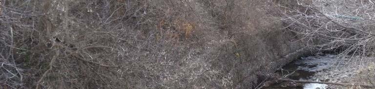
5 Problem and Opportunity Problem: East bank slope is unstable, and requires remedial action Residences and servicing infrastructure in critical condition Opportunity: Develop remediation options that ensures public safety Protect key services Protect environmental and ecological conditions of Pottersburg Creek


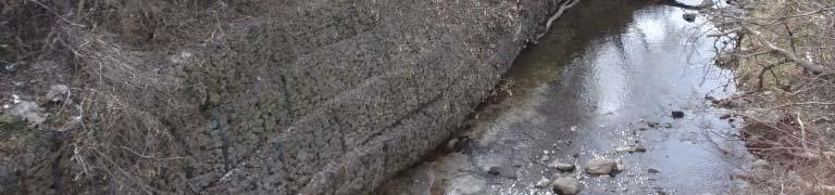
6 Background Natural slope was modified by engineering works in 1989 Portions of slope built steeper than original recommended Residential units and servicing infrastructure located within hazardous slope stability area Focus of this study is on remediation works


7 Environmental Assessment Study The following investigations completed : Geotechnical Soil Chemistry Hydrology and Hydraulics Fluvial Geomorphology Terrestrial Ecology Fisheries Habitat

8 Geotechnical Engineering Inventory of of existing soil conditions (soil and slope stability) Undertaken detailed geotechnical analysis Establish stable top of slope MNR Understanding Natural Hazards


9 Soil Chemistry Elevated levels of PCB s identified in two samples No PCB waste Removal of contaminated material from subject site City of London Ayerswood MCC229


 Erosion")


10 Fluvial Geomorphology Evaluated existing fluvial channel behaviour Downstream of Hamilton Road is a natural meander bent (bend in the river) Erosion rate high at the bend Natural channel will erode bank and Natural channel will erode bank and migrate inland
 Topographic survey completed from Gore Road to Thames River Numerical model to establish water levels under various conditions Used for impact")
11 Hydrology and Hydraulics Hydrology (watershed flows) Establish watershed runoff by applying a water resources model Range of inputs used according to engineering standards Hydraulics (velocities & depths of flow) Topographic survey completed from Gore Road to Thames River Numerical model to establish water levels under various conditions Used for impact assessment


12 Terrestrial Habitat Seven vegetation communities of low land forests identified Two types of deciduous swamps Plants and wildlife corridor within the river corridor catalogued No species at risk found (confirmed No species at risk found (confirmed with MNR)


13 Fisheries Habitat Aquatic habitat evaluated This reach of creek rated between good and fair Creek is spawning ground for fish Number of species found No species at risk identified Small mouth bass Creek chub


 Key servicing")
")

14 Option 1: Do Nothing Slope is unstable and unsafe Residential units located on top of unstable slope (public risk) Key servicing infrastructure at risk (water and sewer) Environmental impacts of potential malfunction or breaks in services Not a viable option


15 Option 2: Buyout of residences Acquire and demolish five residential units Relocate services Remove rock from slope Allow river to erode Creek could freely move and adjust with time No adverse disruption to vegetation and wildlife (no improvement either) Loss of fish habitat with ongoing erosion Cost: High


16 Option 3: New retaining wall 60 m of vertical wall New wall to be owned by individual property p owners Heavy insurance requirements Long term maintenance required Residences and servicing infrastructure to remain Rock berm in front of wall required Elimination of fish spawning grounds Cost: Very High


17 Option 4: Channel Re alignment Residences and services remain To facilitate shift, need new retaining walls near bridge Reshape bank, line with rock Remove contaminated PCB from west bank Design in stream fish habitat improvements Native vegetation planting above rock Minor maintenance required Cost: Moderate
18 Ranking of Options Option 1 Option 2 Option 3 Option 4 Criteria/Option Do Nothing Buyout New Wall Re-alignment Land acquisition Erosion Flooding Stream morphology Aquatic habitat Terrestrial habitat Technical complexity Social Implications Costs Level of Preference c c Low (worst) Medium High (best)
19 Draft Preferred Option Option 4: Channel Re alignment ranked highest Demolition of private property not required No adverse impact of flooding/erosion from re aligned channel Some environmental disruption during construction Fish habitat improvements Loss of riparian vegetation along banks Long term stream health could be improved (new features in channel) Technically feasible Lowest costs
")


20 Next Steps Public input (this meeting) Review agency comments Finalize the report City council 30 day public review period

 Pat Prodanovic, Ph.D., P.Eng.")


21 Public Input Handwritten comments Phone Fax Mail Comments due by: Fb Feb 27, 2013 (two weeks) k) Pat Prodanovic, Ph.D., P.Eng. Water Resources and Marine Engineer Riggs Engineering Ltd Commissioner s Road West Suite 205 London, Ontario N6K 1C7 Phone: Fax: E mail: pprodanovic@riggsengineering.com Billy Haklander, P. Eng. Environmental Services Engineer Stormwater Management Unit Environmental and Engineering Services Department 300 Dufferin St., 9th Floor London, Ontario N6A 4L9 Phone: , ext Fax: E mail: bhakland@london.ca


22 Questions
Public Information Centre September 19 th, 2017
 Public Information Centre September 19 th, 2017 WELCOME! Public Information Centre for the Maple Hill Creek Rehabilitation Class Environmental Assessment Please take the time to sign our sign in sheet
Flood Mitigation Opportunities Study Fourteen Mile Creek & McCraney Creek Systems
 Town of Oakville Flood Mitigation Opportunities Study Fourteen Mile Creek & McCraney Creek Systems November 14, 2013 Study Area The limits of the study area extend from Lake Ontario to Dundas Street. McCraney
South St. Vrain / Hall Meadows Restoration Planning August 20, 2015
 South St. Vrain / Hall Meadows Restoration Planning August 20, 2015 Agenda Introductions Purpose & Goals of Meeting Planning Area Master Plan Restoration Planning: Cost Estimates, Grants, Scope, Timeline
RECOMMENDATION. the financing for the project BE APPROVED in accordance with the Sources of Financing Report attached hereto as Appendix A ;
 TO: FROM: SUBJECT: CHAIR AND MEMBERS CIVIC WORKS COMMITTEE MEETING ON JANUARY 9, 2018 KELLY SCHERR, P.ENG., MBA, FEC MANAGING DIRECTOR, ENVIRONMENTAL & ENGINEERING SERVICES & CITY ENGINEER APPOINTMENT
Project Goals and Scoping
 Prepared for: Boulder County, Colorado Flood Planning & Preliminary Design Services for South St. Vrain Creek Restoration at Hall Ranch and Scoping May 24, 2016 Meeting with General Public In association
Public Information Centre # 2 Flood Mitigation Opportunities Study Fourteen Mile Creek & M c Craney Creek Systems Town of Oakville
 Public Information Centre # 2 Flood Mitigation Opportunities Study Fourteen Mile Creek & M c Craney Creek Systems Town of Oakville Municipal Class Environmental Assessment Study Area The limits of the
WELCOME. Eastern Subwatersheds Stormwater Management Retrofit Study. Online Information Session
 WELCOME Eastern Subwatersheds Stormwater Management Retrofit Study Online Information Session July 31 to Septemberember 19, 2014 1 Eastern Subwatersheds Stormwater Management Retrofit Study This study
Table D1: WC-R1 to WC-R3 (Wilket Creek Park)
") APPENDIX D Table D1: WC-R1 to WC-R3 (Wilket Creek Park) Category of Consideration Criteria Alternative 1 Do Nothing Alternative 2 Local Improvements Alternative 3 Channel Realignment Natural Geomorphic
APPENDIX D Table D1: WC-R1 to WC-R3 (Wilket Creek Park) Category of Consideration Criteria Alternative 1 Do Nothing Alternative 2 Local Improvements Alternative 3 Channel Realignment Natural Geomorphic
Fish Passage Culvert Inspection (FPCI)
") Fish Passage Culvert Inspection (FPCI) Creighton Creek (CR) Watershed FIA Project Number SOTSA 9153004 Prepared for: Tolko Industries Ltd., Okanagan Regional Woodlands Prepared by: Michele Trumbley, RPBio
Fish Passage Culvert Inspection (FPCI) Creighton Creek (CR) Watershed FIA Project Number SOTSA 9153004 Prepared for: Tolko Industries Ltd., Okanagan Regional Woodlands Prepared by: Michele Trumbley, RPBio
PUBLIC INFORMATION CENTRE Class Environmental Assessment For. Black Creek Flood Management
 PUBLIC INFORMATION CENTRE Class Environmental Assessment For Conservation Ontario Class Environmental Assessment for Remedial Flood and Erosion Control Projects (2002) The Class EA for Remedial Flood and
The Beckett s Run Experience. Fort Wayne, Indiana
 The Beckett s Run Experience Fort Wayne, Indiana Introductions Charlie Cochran City of Fort Wayne, Wet Weather Storm & Sewer Engineering Jason Durr, PE Christopher B. Burke Engineering, LLC 2 A Little
Oshawa Creek Watershed Management Plan EXECUTIVE SUMMARY
 Oshawa Creek Watershed Management Plan EXECUTIVE SUMMARY The Central Lake Ontario Conservation Authority (CLOCA) has recognized the need to prepare comprehensive management strategies for all of its watersheds.
Public Information Centre No. 2
 Public Information Centre No. 2 Stoney Creek and Battlefield Creek Flood and Erosion Control Project East Escarpment Watershed Restoration Program Conservation Ontario Class Environmental Assessment Date:
WHY ARE STREAM IMPROVEMENTS NEEDED IN TENNESSEE? TENNESSEE STREAMS
 WHY ARE STREAM IMPROVEMENTS NEEDED IN TENNESSEE? TENNESSEE STREAMS Most diverse aquatic fauna in the country Majority of West TN streams are channelized 36,000 miles of degraded stream are in need of restoration
RIPARIAN AREAS REGULATION
 Definitions and interpretation RIPARIAN AREAS REGULATION 1 (1) In this regulation: Act means the Fish Protection Act; active floodplain means an area of land that supports floodplain plant species and
Public Notice. Public Notice No. Date: April 8, 2016 CENAP-PL-E Comment Period Closes: May 9, 2016
 Public Notice Public Notice No. Date: April 8, 2016 CENAP-PL-E-16-02 Comment Period Closes: May 9, 2016 USACE Philadelphia District: http://www.nap.usace.army.mil COBBS CREEK FISH PASSAGE PROJECT SECTION
3. SHIRLEY S BROOK / WATTS CREEK SUBWATERSHED STUDY COMMITTEE RECOMMENDATION
 3. SHIRLEY S BROOK / WATTS CREEK SUBWATERSHED STUDY COMMITTEE RECOMMENDATION That Council endorse the Shirley s Brook/Watts Creek Subwatershed Study (September 1999) as the technical document to guide
CITY OF NEW WESTMINSTER. Bylaw No. 7033, 2005 RIPARIAN AREAS PROTECTION BYLAW
 CITY OF NEW WESTMINSTER Bylaw No. 7033, 2005 RIPARIAN AREAS PROTECTION BYLAW WHEREAS the City may preserve, protect, restore and enhance the natural environment near streams that support fish habitat from
Risk = Hazard x Consequence
 Tolko Industries Ltd. Cariboo Woodlands Forest Stewardship Plan Major Amendment 26 Watershed Hydrology 1. Introduction: The Cariboo Chilcotin Land Use Plan (CCLUP) and current Tolko Forest Stewardship
Temporary Watercourse Crossing: Culverts
 Temporary Watercourse Crossing: Culverts DRAINAGE CONTROL TECHNIQUE Low Gradient Velocity Control Short Term Steep Gradient Channel Lining Medium-Long Term Outlet Control Soil Treatment Permanent Symbol
Gray s Creek. Gray s Creek
 Gray s Creek 1 Grades F + Forest Conditions B Wetland Conditions C - Surface Water Quality This Watershed Report Card outlines the environmental information for the Gray s Creek watershed as of 2017. The
Woodward Avenue Wastewater Treatment Plant Red Hill Creek Outfall Modification Works Joint Stewardship Board City of Hamilton.
 Woodward Avenue Wastewater Treatment Plant Red Hill Creek Outfall Modification Works Joint Stewardship Board City of Hamilton June 30, 2015 Presentation Outline 1. Background 2. Environmental Assessment
Appendix M. Criteria, Measures and Indicators for Effects Assessment
 Appendix M Criteria, Measures and Indicators for Effects Assessment Appendix M. Criteria, Measures and Indicators for Effects Assessment Objective 1: Naturalization Changes to Aquatic Habitat Disruption,
S.R. 4007, Section 14B PADEP Environmental Assessment Form. Enclosure C Description of Aquatic Habitat
 S.R. 4007, Section 14B PADEP Environmental Assessment Form Description of Aquatic Habitat Cresheim Creek is the only water resource that exists within the project area. No jurisdictional wetlands were
Plan Rollout Presentation July 31, Michael G. Hahn, P.E., P.H. Chief Environmental Engineer. Southeastern Wisconsin Regional Planning Commission
 Plan Rollout Presentation July 31, 2014 Michael G. Hahn, P.E., P.H. Chief Environmental Engineer Southeastern Wisconsin Regional Planning Commission # 219703 Racine County Flooding Recommendations and
Conceptual Design and Feasibility of a Natural Fishway at the Fremont BART Weir, Alameda Creek, California
 Conceptual Design and Feasibility of a Natural Fishway at the Fremont BART Weir, Alameda Creek, California Final Report September 2005 Prepared by Center for Ecosystem Management and Restoration, Oakland,
DECISION MEMO. West Fork Blacktail Deer Creek Hardened Crossing
 Page 1 of 6 Background DECISION MEMO USDA Forest Service Madison Ranger District Madison County T12S, R4W, Section 30 The project is in the Gravelly Landscape, Snowcrest Recommended Wilderness Management
Dr. Paul Villard Toronto and Region International Erosion Control Association March 27, 2012
 Dr. Paul Villard Toronto and Region International Erosion Control Association March 27, 2012 GEOMORPHOLOGICAL CHARACTERIZATION CREEK AND SHORELINE RESTORATION l FLUVIAL AND COASTAL HAZARD ASSESSMENT HYDRAULIC
Stage 1 Technical Memorandum
 Appendix A Stage 1 Technical Memorandum 2016 Google TECHNICAL MEMORANDUM One River Master Plan Environmental Assessment: Stage 1 Work Plan PREPARED FOR: COPY TO: PREPARED BY: Ashley Rammeloo, City of London
CARP CREEK EMBANKMENT RESTORATION Conservation Ontario Class Environmental Assessment Public Information Centre March 8, 2018 Welcome!
 CARP CREEK EMBANKMENT RESTORATION Conservation Ontario Class Environmental Assessment Public Information Centre March 8, 2018 Welcome! Conservation Ontario Class Environmental Assessment Approach The Carp
EXHIBIT 9. Supplemental Environmental Projects Plan
 EXHIBIT 9 Supplemental Environmental Projects Plan I. Introduction Defendants shall perform the streambank stabilization, leachate control, greenway creation, and in-stream restoration projects described
Watershed Hydrology: Go with the flow. Greg Jennings, PhD, PE
 Watershed Hydrology: Go with the flow Greg Jennings, PhD, PE jenningsenv@gmail.com Streams What are your CHALLENGES? Hydrology too much water Pollutants upstream and on-site Vegetation wrong plants, wrong
IAFSM 2010 Annual Conference. City of Rockford Keith Creek Greenway Flood Mitigation Project
 IAFSM 2010 Annual Conference City of Rockford Keith Creek Greenway Flood Mitigation Project March 10, 2010 Introduction Problem Overview 1890 s Building of homes along Keith Creek 1920 s Home construction
Public Information Centre No. 2 June 15, :00 8:00 pm. Valley Park Community Centre (GYM B) 970 Paramount Drive Stoney Creek
 970 Paramount Drive Stoney Creek") Public Information Centre No. 2 June 15, 2017 6:00 8:00 pm Valley Park Community Centre (GYM B) 970 Paramount Drive Stoney Creek Please complete the sign-in sheet and review display materials. The project
Public Information Centre No. 2 June 15, 2017 6:00 8:00 pm Valley Park Community Centre (GYM B) 970 Paramount Drive Stoney Creek Please complete the sign-in sheet and review display materials. The project
I. Welcome & Introductions WPAC History (Paul Racette, PEC)
") Poquessing Creek Watershed ACT 167 STORM WATER MANAGEMENT PLAN Public Hearing July 10, 2012 I. Welcome & Introductions ---------- WPAC History (Paul Racette, PEC) Primary WPAC Members: Bucks County: Bensalem
Poquessing Creek Watershed ACT 167 STORM WATER MANAGEMENT PLAN Public Hearing July 10, 2012 I. Welcome & Introductions ---------- WPAC History (Paul Racette, PEC) Primary WPAC Members: Bucks County: Bensalem
Chapter 10 Natural Environment
 Chapter 10 Natural Environment Existing Conditions The Natural Environment Element addresses the protection, conservation, preservation, and restoration of the natural resources the Bayview Ridge Subarea,
PUBLIC INFORMATION CENTRE
 June 24, 2014 PUBLIC INFORMATION CENTRE MUNICIPAL CLASS ENVIRONMENTAL ASSESSMENT SCHEDULE B MUNICIPAL SERVICES FOR THE MARY LAKE ESTATES SUBDIVISION Buildings Municipal Infrastructure Transportation Industrial
Supplemental Watershed Plan Agreement No. 10 for Neshaminy Creek Watershed Core Creek Dam (PA-620) Bucks County, Pennsylvania
 Bucks County, Pennsylvania") Supplemental Watershed Plan Agreement No. 10 for Neshaminy Creek Watershed Core Creek Dam (PA-620) Bucks County, Pennsylvania Project Authorization USDA's Small Watershed Program is carried out under the
Supplemental Watershed Plan Agreement No. 10 for Neshaminy Creek Watershed Core Creek Dam (PA-620) Bucks County, Pennsylvania Project Authorization USDA's Small Watershed Program is carried out under the
7.0 WATER-BASED CONTROL MEASURES
 7.0 WATER-BASED CONTROL MEASURES 7.1 IDENTIFICATION AND DESCRIPTION OF CONTROL MEASURES Table 7-1 lists the water-based options being considered for implementation in the initial screening stage. Descriptions
Surface Water. Solutions for a better world
 1 Surface Water Solutions for a better world Our Surface Water Services Expertise Growing worldwide awareness of water scarcity has encouraged water preservation programs, better irrigation techniques
Chehalis Basin Strategy Programmatic SEPA Draft EIS
 Chehalis Basin Strategy Programmatic SEPA Draft EIS History of Flooding I-5 closed in 1990, 1996, 2007, 2009 Five largest flood events occurred since 1986 2 History of Habitat Degradation Harvest has been
Meacham Creek Restoration Project
 Meacham Creek Restoration Project Meacham Creek Restoration Project Umatilla National Forest Walla Walla Ranger District Michael Rassbach, District Ranger Public Scoping Document Proposal Summary The Walla
Environmental Resource Inventories. What are ERIs? Significance of information How to use them
 Environmental Resource Inventories What are ERIs? Significance of information How to use them Environmental Resource Inventory - ERI Compiled by the environmental commission Information about the natural
Appendix P. U.S. Fish and Wildlife Service Planning Aid Letter
 Appendix P U.S. Fish and Wildlife Service Planning Aid Letter This page is intentionally left blank. United States Department of the Interior FISH AND WILDLIFE SERVICE Missouri Ecological Services Field
Transportation Association of Canada Environmental Achievement Award Nomination Submission:
 Transportation Association of Canada Environmental Achievement Award Nomination Submission: Highway 26 New Wildlife Passage and Enhancements Ontario Ministry of Transportation, Central Region Nominees:
OFFICE OF STRUCTURES MANUAL ON HYDROLOGIC AND HYDRAULIC DESIGN CHAPTER 3 POLICY AND PROCEDURES
 OFFICE OF STRUCTURES MANUAL ON HYDROLOGIC AND HYDRAULIC DESIGN CHAPTER 3 POLICY AND PROCEDURES April 28, 2016 Table of Contents 3.1 Introduction... 2 3.1.1 Purpose of Chapter 3... 2 3.1.2 Policy vs. Design
COMPREHENSIVE ENVIRONMENTAL IMPACT STUDY & MANAGEMENT PLAN South Albion Bolton Community Plan Employment Needs & North Hill Commercial Lands Study
 COMPREHENSIVE ENVIRONMENTAL IMPACT STUDY & MANAGEMENT PLAN South Albion Bolton Community Plan Employment Needs & North Hill Commercial Lands Study Part A Study Components Background Information Review
CLEARWATER TOWNSHIP WATER QUALITY ACTION PLAN
 CLEARWATER TOWNSHIP WATER QUALITY ACTION PLAN Elk-River-Chain-of-Lakes Gaps Analysis Project The Watershed Center Grand Traverse Bay Michigan Department of Environmental Quality July 2011 Purpose The Grand
APPENDIX C. Public Consultation Centre (PCC) Displays. Appendix C1 PCC#1 Appendix C2 PCC#2 Appendix C3 PCC#3
 Displays. Appendix C1 PCC#1 Appendix C2 PCC#2 Appendix C3 PCC#3") APPENDIX C Public Consultation Centre (PCC) Displays Appendix C1 PCC#1 Appendix C2 PCC#2 Appendix C3 PCC#3 Appendix C1 PCC#1 Appendix C2 PCC#2 Township of Red Rock Class Environmental
APPENDIX C Public Consultation Centre (PCC) Displays Appendix C1 PCC#1 Appendix C2 PCC#2 Appendix C3 PCC#3 Appendix C1 PCC#1 Appendix C2 PCC#2 Township of Red Rock Class Environmental
COON CREEK WATERSHED DISTRICT PERMIT REVIEW Mississippi Dr Coon Rapids, MN SQ FT Residence on 0.64 Acre Lot
 17-082 Van Sloun Residence, Page 1 of 5 COON CREEK WATERSHED DISTRICT PERMIT REVIEW MEETING DATE: May 8, 2017 AGENDA NUMBER: 17 FILE NUMBER: 17-082 ITEM: Van Sloun Residence RECOMMENDATION: Approve with
Contents. Section 1 Data Review and Discussion. Section 2 Methodology
 Contents Section 1 Data Review and Discussion 1.1 Introduction and Background... 1-1 1.2 1996 Stormwater Management Plan... 1-3 1.3 2004 Two Mile Branch Watershed Management Plan... 1-5 1.4 NPDES Mapping
Detailed Options Evaluation
 Appendix F Detailed Options Evaluation 06 Google Category & Criterion Description Measure/Indicator Natural Environment Rating Scale for Measuring Impacts Comparative Evaluation Score Comparative Evaluation
Eco-engineering on the Edge:
 Eco-engineering on the Edge: Decision Making for Stream Restoration and Stabilization in High Profile or Risk Environments Dan Salas, Ecologist Cardno JFNew Types of Risk Physical/Structural = Property
ENVIRONMENT ACT TERMS OF REFERENCE NOVA SCOTIA DEPARTMENT OF TRANSPORTATION AND PUBLIC WORKS. Beaver Bank Bypass
 ENVIRONMENT ACT TERMS OF REFERENCE NOVA SCOTIA DEPARTMENT OF TRANSPORTATION AND PUBLIC WORKS Beaver Bank Bypass Highway 101 to the Beaver Bank Road Halifax County, NS NOVA SCOTIA DEPARTMENT OF THE ENVIRONMENT
GENERAL SPECIFICATION FOR ENVIRONMENTAL PROTECTION FOR CONSTRUCTION IN WATERBODIES AND ON WATERBODY BANKS
 ONTARIO PROVINCIAL STANDARD SPECIFICATION METRIC OPSS.PROV 182 NOVEMBER 2012 GENERAL SPECIFICATION FOR ENVIRONMENTAL PROTECTION FOR CONSTRUCTION IN WATERBODIES AND ON WATERBODY BANKS TABLE OF CONTENTS
Issues, Concerns & Constraints
 Identifying Issues, Concerns & Constraints In order to identify the issues and concerns of watershed residents, several methods of gathering public input were employed. The Brodhead Watershed Association
WELCOME. Eastern Subwatersheds Stormwater Management Retrofit Study. Online Information Session #2 June 15 to July 13, 2018
 WELCOME Eastern Subwatersheds Stormwater Management Retrofit Study Online Information Session #2 June 15 to July 13, 2018 1 Eastern Subwatersheds Stormwater Management Retrofit Study This study is one
Request for Proposal Scope Development Guide. Asotin County Geomorphic Assessment. and. Conceptual Restoration Plan
 Request for Proposal Scope Development Guide Asotin County Geomorphic Assessment and Conceptual Restoration Plan Asotin County Conservation District December 3, 2015 1 1.0 INTRODUCTION The Asotin County
CATEGORY a protection of the natural environment, its ecosystems and biodiversity.
 29. ENVIRONMENTAL DEVELOPMENT PERMIT AREA CATEGORY a protection of the natural environment, its ecosystems and biodiversity. The requirement to obtain an environmental development permit is cited in Section
THE WATERSHED The watershed is an area of land that drains into a stream. This includes both the surface runoff and groundwater. Because a stream is m
 Understanding Streams A stream is the product of its watershed. Good land use in the watershed will be reflected in the stream. MOST PEOPLE enjoy the captivating qualities of flowing water. But streams
Maitland Valley WATERSHED
 Maitland Valley WATERSHED Report Card 2018 Maitland Conservation has prepared this report card as a summary of the state of your forests, wetlands, and water resources. WHERE ARE WE? We are one of 36 Conservation
Wood-Pawcatuck Watershed Flood Resiliency Management Plan
 Wood-Pawcatuck Watershed Flood Resiliency Management Plan Project Steering Committee Kickoff Meeting March 26, 2015 Wood-Pawcatuck Watershed Association Meeting Agenda 10:00 10:05 Welcome and Opening Remarks
Stream Restoration in the Urban Environment Concepts and Considerations
 Stream Restoration in the Urban Environment Concepts and Considerations The Restoration of Our Rivers; October 5, 2012 Matthew A. Van Eps, PE & Sandi J. Formica: Watershed Conservation Resource Center
Don t Mow. Let it Grow!
 Don t Mow. Let it Grow! The Science Behind the Need for Riparian Buffer Protection. Chelsea Walker, WCD Watershed Specialist chelsea@wcdpa.com 724-837-5271 What is a Riparian Buffer? A riparian buffer
CHAPTER 4 WATERSHED PLAN GOALS & OBJECTIVES
 4.0 Introduction CHAPTER 4 WATERSHED PLAN GOALS & OBJECTIVES After the watershed analysis had been completed, the next step in the planning process followed by the group was to come up with goals and objectives
COASTAL CONSERVANCY. Staff Recommendation June 16, 2005 ESTERO AMERICANO NATURE PRESERVE ENHANCEMENT PROJECT
 COASTAL CONSERVANCY Staff Recommendation June 16, 2005 ESTERO AMERICANO NATURE PRESERVE ENHANCEMENT PROJECT File No. 05-017 Project Manager: Richard Retecki RECOMMENDED ACTION: Authorization to disburse
Please complete the sign-in sheet and review display materials.
 Municipal Class Environmental Assessment Please complete the sign-in sheet and review display materials. As you move through the information presented today, we encourage you to ask questions and provide
D Olive Watershed. Path Toward Restoration
 D Olive Watershed Path Toward Restoration Water is the most critical resource issues of our lifetime and our children s lifetime. The health of our waters is the principal measure of how we live on the
Lower San Joaquin River Feasibility Study PLAN FORMULATION ADDENDUM
 PLAN FORMULATION ADDENDUM Non-Structural Measure Descriptions Elevate Critical Infrastructure This measure would raise at-risk critical structures above the design inundation level. Elevation would be
VEGETATIVE, WATER, FISH AND WILDLIFE RESOURCES POLICIES
 VEGETATIVE, WATER, FISH AND WILDLIFE RESOURCES POLICIES The County will: GOALS AND OBJECTIVES 1.1 Conserve, Enhance, Protect, Maintain and Manage Vegetative, Water, Fish and Wildlife Resources Promote
ADDENDUM #1 RFP WOLFTRAP CREEK STREAM RESTORATION
 ADDENDUM #1 February 6, 2015 RFP 15-03 WOLFTRAP CREEK STREAM RESTORATION ******ATTENTION BIDDERS****** (To be completed and returned with bid response) A request was made that the Stormwater Local Assistance
COLE ENGINEERING GROUP LTD.
 CITY OF MARKHAM PROJECT FILE Stormwater Management Facilities Retrofit Municipal Class EA ES12-0316 COLE ENGINEERING GROUP LTD SEPTEMBER 2015 [ Month Year ] HEAD OFFICE 70 Valleywood Drive Markham, ON
COTTON CREEK CULVERT REPLACMENT
 COTTON CREEK CULVERT REPLACMENT Integrating Mobility with Environmental Innovation Located along a scenic section of Highway 3/95 in British Columbia, Moyie Bluffs, a 6.5 km stretch of inland highway had
RDEK Elk River Priority Flood and Erosion Mitigation Sites. Conceptual Design Report
 RDEK Elk River Priority Flood and Conceptual Design Report May 2016 Lotic Environmental Ltd 2193 Mazur Road Cranbrook BC V1C 6V9 Elk River Watershed Alliance 891-2nd Avenue Fernie BC V0B 1M0 Suggested
Environmental Check List Georgia Environmental Policy Act
 Environmental Check List Georgia Environmental Policy Act Project No. : Project Name: GEORGIA IS AREA AFFECTED? IF AFFECTED, HOW SEVERELY? AREA/CATEGORY NO YES UNKNOWN MINOR MEDIAN MAJOR UNKNOWN 1. Wetlands
THE RED HILL VALLEY PROJECT STORMWATER MANAGEMENT DESIGN. Ronald B. Scheckenberger, M. Eng., P. Eng. Philips Engineering Ltd.
 THE RED HILL VALLEY PROJECT STORMWATER MANAGEMENT DESIGN Ronald B. Scheckenberger, M. Eng., P. Eng. Philips Engineering Ltd. Chris Murray Acting Director, Red Hill Valley Project City of Hamilton Paper
Natural Systems Planning Primer
 Natural Systems Planning Primer Lise.Guevremont@ottawa.ca Amy.Macpherson@ottawa.ca Land Use and Natural Systems Unit Planning and Growth Management November 2015 1 Welcome Policy Framework Development
City of Mississauga Environmental Impact Studies Terms of Reference 2002
 City of Mississauga Environmental Impact Studies Terms of Reference 2002 1.0 INTRODUCTION To ensure in so far as possible, both private and public developments are consistent with Natural Heritage and
Watershed. Rigaud River Report Card. Grades: Forest Conditions Wetland Conditions Surface Water Quality
 Watershed Report ard Grades: + onditions Wetland onditions Surface Water Quality This Watershed Report ard outlines the environmental information for the watershed as of 2006. The information provides
Understanding and Restoring Natural Floodplain Function. Gary James CTUIR Fisheries Program Manager
 Understanding and Restoring Natural Floodplain Function Gary James Fisheries Program Manager Future of Our Salmon Technical Workshop on Healthy Floodplains Spokane, WA - August 16-18, 2016 Presentation
Welcome South London Wastewater Servicing Study. Municipal Class Environmental Assessment Master Plan Public Information Centre.
 Welcome South London Wastewater Servicing Study Municipal Class Environmental Assessment Master Plan Public Information Centre February 26, 2018 The purpose of this Public Information Centre (PIC) is to:
Chapter 3 Dispersion BMPs
 Chapter 3 Dispersion BMPs 3.1 BMP L611 Concentrated Flow Dispersion 3.1.1 Purpose and Definition Dispersion of concentrated flows from driveways or other pavement through a vegetated pervious area attenuates
WATERSHED. Maitland Valley. Report Card 201
 Maitland Valley WATERSHED Report Card 201 The Maitland Valley Conservation Authority has prepared this report card as a summary on the state of our forests, wetlands, surface water, and ground water resources.
Programmatic General Permit Army Corps of Engineers Connecticut Addendum
 Programmatic General Permit Army Corps of Engineers Connecticut Addendum DEP USE ONLY NAE#: DEP #: PGP Screening Date: Determinations: Eligible Category 2 Eligible Category 1 Individual Permit Print or
Otonabee Region WATERSHED
 Otonabee Region WATERSHED Report Card 2018 Otonabee Conservation has prepared this report card as a summary of the state of your forests, wetlands, and water resources using data from 2012 to 2016. WHERE
LAKE CHEMUNG GENOA TOWNSHIP LIVINGSTON COUNTY, MICHIGAN STORM DRAIN AND TRIBUTARY STUDY. Prepared for:
 LAKE CHEMUNG GENOA TOWNSHIP LIVINGSTON COUNTY, MICHIGAN STORM DRAIN AND TRIBUTARY STUDY Prepared for: Lake Chemung Riparian Association c/o 1125 Sunrise Park Drive Howell, MI 48843 Prepared by: Progressive
Town of Aurora Stream Management Master Plan PUBLIC INFORMATION CENTRE May 1 st, 2018
 Town of Aurora Stream Management Master Plan PUBLIC INFORMATION CENTRE May 1 st, 2018 Your comments are encouraged and appreciated, as this will provide us an opportunity to address project issues and
NATIONAL STREAM AND AQUATIC ECOLOGY CENTER
 NATIONAL STREAM AND AQUATIC ECOLOGY CENTER The National Stream and Aquatic Ecology Center is a technology transfer unit of the National Forest System (NFS) Watershed, Fish, Wildlife, Air and Rare Plants
BMP 5.4.2: Protect /Conserve/Enhance Riparian Areas
 BMP 5.4.2: Protect /Conserve/Enhance Riparian Areas The Executive Council of the Chesapeake Bay Program defines a Riparian Forest Buffer as "an area of trees, usually accompanied by shrubs and other vegetation,
Appendix C Previous Studies
 Appendix C Previous Studies Overview Valley Creek has been the subject of many studies and watershed assessments over the past four decades, with the scope and breadth of these studies varying significantly
ANCR INDIVIDUAL RESPONSES SUMMARY: 2/11/04 WATER RESOURCES GOALS AND OBJECTIVES
 ANCR INDIVIDUAL RESPONSES SUMMARY: 2/11/04 WATER RESOURCES GOALS AND OBJECTIVES Goal 1: Protect the health and safety of the Dane County population. a. Prevent development that may have an adverse effect
PROJECT SCOPE OF WORK CITY OF TOWN AND COUNTRY STORMWATER PROGRAM
 PROJECT SCOPE OF WORK CITY OF TOWN AND COUNTRY STORMWATER PROGRAM Project Name: 1338 Thornhill Dr Project ID Number: 1-3 Problem: Creek bank erosion is occurring along from the northern property line at
What is the Terms of Reference?
 What is the Terms of Reference? Framework for content of the Environmental Assessment Certificate Application Provides the scope of technical studies and consultation processes with the public and First
Climate Smart Resiliency Plans, Policies, and Projects Improvement Plan for: The Town of Caroline
 Climate Smart Resiliency Plans, Policies, and Projects Improvement Plan for: The Town of Caroline Overview This document should serve as a supplement to the Climate Smart Resiliency Planning Evaluation
Municipal Stormwater Management Plan Prepared For The Borough of Cape May Point By Van Note-Harvey Associates VNH File No.
 Municipal Stormwater Management Plan Prepared For The Borough of Cape May Point By Van Note-Harvey Associates 2005 VNH File No. 35317-210-21 Table of Contents Introduction... 3 Goals... 3 Storm water Discussion...
DIRECTIONS FOR STRATEGY DEVELOPMENT
 DIRECTIONS FOR STRATEGY DEVELOPMENT CHAPTER 9 This chapter is designed to identify issues which may be considered during the development of a watershed strategy. In the previous Don, Humber, and Rouge
Welcome to the Boulevard Lake Dam Class Environmental Assessment. Public Information Session #1. June 14, 2016
 Welcome to the Boulevard Lake Dam Class Environmental Assessment Public Information Session #1 June 14, 2016 Boulevard Dam - Overview Built approximately 100 years ago Owned and operated by the City of
Toronto and Region Conservation 2017 Progress & 2018 Budget Peel Council
 Toronto and Region Conservation 2017 Progress & 2018 Budget Peel Council November 16, 2017 1 2 Input $4,248,000 44 Projects Activities Watershed 2017 Output Increased coverage of Flood Monitoring and Real
FINDING OF NO SIGNIFICANT IMPACT GOODING FLOOD CONTROL PROJECT REHABILITATION GOODING, IDAHO SEPTEMBER 2016
 FINDING OF NO SIGNIFICANT IMPACT GOODING FLOOD CONTROL PROJECT REHABILITATION GOODING, IDAHO SEPTEMBER 2016 1. INTRODUCTION/PROPOSED ACTION The U.S. Army Corps of Engineers, Walla Walla District (Corps),