VISualize2012: Climate Change and Environmental Monitoring
|
|
|
- Pauline Lamb
- 6 years ago
- Views:
Transcription
1 VISualize2012: Climate Change and Environmental Monitoring ESTIMATION OF ABOVE GROUND BIOMASS IN RESTORED JUVENILE MANGROVE STANDS: EVALUATION OF SPECTRAL AND IMAGE DOMAIN OPERATORS UTILIZING AIRBORNE HYPERSPECTRAL DATASETS SYSTEMS APPLICATION AND DEVELOPMENT UNIT, FOREST DEPARTMENT SARAWAK, WISMA SUMBER ALAM, PETRA JAYA KUCHING, SARAWAK, MALAYSIA

 Adoption of technology")
2 FOREST DEPARTMENT SARAWAK (Geospatial Initiative) (VISION) Tobeanagencyofexcellence: management conservation and protection of tropical forests. FOREST DEPARTMENT SARAWAK HQ (Kuching, Sarawak) Adoption of technology (geospatial) into daily operations to increase efficiency and effectiveness.

3 AIRBORNE HYPERSPECTRAL IMAGING SYSTEM (AHIS) Operator Display/Controls Flight Mission Coordinator On-Board CPU: AISA Rack-PC Airborne Platform (KingAir Beechcraft)


4 HYPERSPECTRAL IMAGING COMPONENTS Sensor Head : AISA Eagle-II Sensor Head : AISA Eagle-II Stabilized Platform: SOMAG 3000 Gyro IMU: Oxford-RT GPS/INS IMU: Oxford-RT GPS/INS Stabilized Platform: SOMAG 3000 Gyro


5 AERIAL ENFORCEMENT AND MONITORING SYSTEM Operator Display & Controls Hyperspectral Sensor Hyperspectral Imaging System & Gimbal Component fitted onboard Bell 206L4 GPS/INS Unit Mobile Navigation & Pilot Display

6 RESTORATION OF MANGROVE FORESTS AND COASTAL ECOSYSTEM Rehabilitation of degraded coastal forests (9 th -10 th Malaysia Plan Development Project: ) Objectives: coastal protection soil stabilization marine/wildlife habitat REDD+ initiative* * Work-in progress to develop a tool for remotely estimating biomass of juvenile stands as an application for the mangrove rehabilitation project.
7 CHARACTERISTICS OF PLANTED MANGROVE STANDS Varying growth rates: Species Spatial position in the stand Competition Vigor Age. In the Matang Mangrove Forest Reserve in Malaysia, Putz and Chan (1986) reported that diameter growth rates of R. apiculata trees were cm( in) for diameter sizeclassesfrom10to60cm(4 24in). Watson (1928) estimated that under Malaysian conditions mean annual increment (MAI) of stilt mangroves culminated at around 10.6 m3/ha/yr(152 ft3/ac/yr) at years.
 Habitat: Intertidal wetland")

,")
8 Characteristics of Stilt Mangroves (R.apiculata) Habitat: Intertidal wetland zone (0-6m) between mean sea level and highest tide. Standing Biomass: mt/ha Main products: Timber (poles, stilts), fuelwood, charcoal, medicine Source: Duke, N.C
 Slow growth rate as compared to other types of introduced tree plantings")
 2009 Shortage of planting stock (other suitable species Avicennia; Sonneratia)")
9 Issues/constrain: REFORESTATION EFFORTS Site suitability (wave energy; driftwood; soil substrate) Slow growth rate as compared to other types of introduced tree plantings such as Acacia(3.3 cm/yr) 2009 Shortage of planting stock (other suitable species Avicennia; Sonneratia) Planting generalized using R.apiculata seedlings (varying success rate) 2012
10 MANGROVE RESTORATION (MONITORING AND MEASURING) Monitor forest cover change of areas under mangrove/previously mangrove cover. Total area under forest Changes to forest cover/land-use Measuring productivity of mangrove stands Old growth natural mangrove stand Juvenile planted mangrove stands*
11 MONITORING MANGROVE REFORESTATION ACTIVITIES Monitoring systems should provide estimates that are transparent and consistent, as far as possible accurate, and that reduce uncertainties, and results are available and suitable for review asagreedbythecop. (COP 15 Decision on Methodological Guidance-support of REDD activities) Remote sensing role: Consistent reporting through development of standardized protocol (tool) for processing and analyzing data to final information product.
12 DEVELOPMENT OF A SPECIFIC TOOL FOR REMOTELY MONITORING JUVENILE MANGROVE STANDS Management requirements: Project value Applicability (National operations) Type of information: Planting progress (size of area planted, species composition, no. of saplings planted and mortality). Productivity (Above Ground Biomass) of planted stands ~ REDD+ initiative. Standardization and simplification of workflow
13 MONITORING MANGROVE REFORESTATION ACTIVITIES Constrain of current remote sensing capabilities: High spatial resolution but low spectral capabilities to discriminate between mangrove canopies with other vegetation and reduce background influence. High spectral resolution but coarse spatial details resulting in mixed response of target materials with background. Spectral un-mixing would not resolve detail structural properties of single crowns.
14 MONITORING MANGROVE REFORESTATION ACTIVITIES High fidelity imaging systems: Spectral capability to distinguish between target and other background materials. High geometric detail to effectively resolve single canopies of small statured(dwarf) stands. Derive biophysical variables (crown area; crown volume) to better estimate stand productivity (biomass)
15 DERIVATION OF ABOVE GROUND BIOMASS (AGB) Calibration of Airborne Dataset with Field Sampling Develop Biomass regression (single tree) based upon relationship between crown structural characteristics (as observed from image datasets) and biomass components (trunk, branch, prop-root, leaf and total above-ground biomass). Aboveground Biomass estimates based on: Field measurements (components) Allometric equation: Calibration of field measurement with Final Vector Product of the airborne hyperspectral dataset (Biomass Estimation Tool). Compare with existing allometric equations: AGB = x (ρ.dbh2.h) Chave et.al (2005)
16 DERIVATION OF BIOMASS ESTIMATES (High Resolution Image Datasets) Emphasis placed on: Sensor band placement and bandwidth to optimise separability between target classes. Spectral enhancement to detect salient features in dataset and suppress background influence. Enhancement of canopy geometric features such as to coincide with the purpose of being able to delineate individual tree crowns from imagery.
17 SPECTRAL ENHANCEMENT Derivative transformation (IDL s DERIV function David Gorodetzky): 1-Dλ(i)=(Rλ(j+1)- Rλ(j))/ Δ λ No need for equally spaced band positions as function adopts Langrangian interpolation. Use only 1 st order to minimise noise amplification at higher order
18 Spatial Derivative(Edge Enhancement) Based on neighbourhood functions(convolution mask) on image datasets. Spatial derivative transformation on original image to find changes in pixel brightness gradient in horizontal(gx) and Vertical(Gy) direction: Roberts Operator(2x2 gradient) Sobel Operator(3x3) +


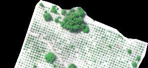
19 STUDY SITE
20 HYPERSPECTRAL IMAGE DATASET (TRUE COLOR COMPOSITE 3 FLIGHT LINES ACQUIRED ON 8 TH MAY 2012)

 Image")

21 CHANGES IN LUFC AT STUDY SITE ( ) Image courtesy of: Digital Globe

22 COLLECTION OF FIELD DATA
23 ABOVE GROUND BIOMASS COMPONENTS (LEAVES; BRANCH; TRUNK; PROP-ROOTS) Field oven design (derived from Spectranomics project, Carnegie Airbrone Observatory)


24 CONDITIONS OF PLANTED MANGROVE STANDS
25 SPECTRAL RESPONSE (MANGROVE VEGETATION AND SOIL BACKGROUND)
26 SPECTRAL VARIATIONS (CANOPY CLASSES) NIR 550nm 680nm VIS


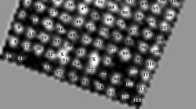

27 INDIVIDUAL CROWN DELINEATION (20m X 20m SUB-PLOT)


28 INDIVIDUAL CROWN DELINEATION (1 HECTARE PLOT)


29 BIOMASS Estimation Tool (Phase-1)
30 ACKNOWLEDGEMENT FOREST DEPARTMENT SARAWAK Ministry of Natural Resource and Environment, Malaysia for funding project (10 th Malaysia Plan P ) Technical comments ITT-VIS regional office in Japan(Bernard Lawes).
Integration of forest inventories with remotely sensed data for biomass mapping: First results for tropical Africa
 Integration of forest inventories with remotely sensed data for biomass mapping: First results for tropical Africa Alessandro Baccini Nadine Laporte Scott J. Goetz Mindy Sun Wayne Walker Jared Stabach
Study on Coastal Protection and Production Functions of Mangrove Vegetation in Thanh Phu Natural Reserve, Mekong Delta, Vietnam
 Study on Coastal Protection and Production Functions of Mangrove Vegetation in Thanh Phu Natural Reserve, Mekong Delta, Vietnam Nguyen Thi Kim Cuc, Thuyloi University, Hanoi, Vietnam nguyencucvn@gmail.com
Hyperspectral information for vegetation monitoring
 Hyperspectral information for vegetation monitoring Gaia Vaglio Laurin DIBAF Università della Tuscia, CMCC Activities supported by the EU H2020 BACI grant #640176 Italian Space Agency, Rome, 1-3 March
Estimation of above-ground biomass of mangrove forests using high-resolution satellite data
 Estimation of above-ground biomass of mangrove forests using high-resolution satellite data Yasumasa Hirata 1, Ryuichi Tabuchi 2, Saimon Lihpai 3, Herson Anson 3*, Kiyoshi Fujimoto 4, Shigeo Kuramoto 5,
K&C Phase 3 Brief project essentials
 K&C Phase 3 Brief project essentials Aboveground Biomass and Carbon Stock Mapping and Changes Monitoring in the Forest of Peninsular Malaysia Using L-Band ALOS Palsar and JERS-1 Khali Aziz Hamzah & Hamdan
Pilot Project National Forest Inventory (NFI) in Suriname. Cayenne, April 2014
 in Suriname. Cayenne, April 2014") Pilot Project National Forest Inventory (NFI) in Suriname Cayenne, 28 29 April 2014 Timeline 2009: COP15; Meetings between Suriname and Austria. 2010: Technical meetings between SBB and Austria; Austrian
Pilot Project National Forest Inventory (NFI) in Suriname Cayenne, 28 29 April 2014 Timeline 2009: COP15; Meetings between Suriname and Austria. 2010: Technical meetings between SBB and Austria; Austrian
Integration of Alos PalSAR and LIDAR IceSAT data in a multistep approach for wide area biomass mapping
 Integration of Alos PalSAR and LIDAR IceSAT data in a multistep approach for wide area biomass mapping. Above Ground Biomass (carbon) mapping and monitoring: Importance Supporting UNFCC KP, REDD+, Monitoring
Forest Biomass Estimation, Australia
 Forest Biomass Estimation, Australia 1 Richard Lucas, 2 John Armston, 1 Peter Bunting, 1 Daniel Clewley, 2 Peter Scarth, 2 Michael Schmidt, 2 Arnon Accad, 3 Paul Siqueira and 3 Yang Lei 1 Institute of
K&C Phase 3 Brief project essentials
 K&C Phase 3 Brief project essentials Aboveground Biomass and Carbon Stock Mapping and Changes Monitoring in the Forest of Peninsular Malaysia Using L-Band ALOS Palsar and JERS-1 Hamdan Omar & Khali Aziz
Forestry and Agricultural Greenhouse Gas Modeling Forum # Shepherdstown, WV
 Forestry and Agricultural Greenhouse Gas Modeling Forum #4 March 6-8, 6 2007 Shepherdstown, WV Overview of scientific, technical and methodological issues related to reducing emissions from deforestation
In this presentation we are going to talk about monitoring, measuring and the quantification of carbon stocks in tropical peatland forests.
 In this presentation we are going to talk about monitoring, measuring and the quantification of carbon stocks in tropical peatland forests. 1 By way of introduction, we will see why we care about peatlands,
Mapping Hemlocks to Estimate Potential Canopy Gaps Following Hemlock Woolly Adelgid Infestations in the Southern Appalachian Mountains
 Mapping Hemlocks to Estimate Potential Canopy Gaps Following Hemlock Woolly Adelgid Infestations in the Southern Appalachian Mountains Tuula Kantola, Maria Tchakerian, Päivi Lyytikäinen-Saarenmaa, Robert
Remote Sensing of Mangrove Structure and Biomass
 Remote Sensing of Mangrove Structure and Biomass Temilola Fatoyinbo 1, Marc Simard 2 1 NASA Goddard Space Flight Center, Greenbelt, MD USA 2 NASA Jet Propulsion Laboratory, Pasadena, CA USA Introdution
Remote Sensing for Fire Management
 Remote Sensing for Fire Management FOR 435/535: Remote Sensing for Fire Management 5. Severity A Source of Confusion Field Measures Remote Sensing Measures FOR 435: A Source of Confusion The terms fire
Forest Assessments with LiDAR: from Research to Operational Programs
 Forest Assessments with LiDAR: from Research to Operational Programs David L. Evans Department of Forestry Forest and Wildlife Research Center Mississippi State University Forest Remote Sensing: Then and
Remote sensing as a tool to detect and quantify vegetation properties in tropical forest-savanna transitions Edward Mitchard (University of Edinburgh)
") Remote sensing as a tool to detect and quantify vegetation properties in tropical forest-savanna transitions Edward Mitchard (University of Edinburgh) Presentation to Geography EUBAP 10 th Oct 2008 Supervisor:
Remote sensing as a tool to detect and quantify vegetation properties in tropical forest-savanna transitions Edward Mitchard (University of Edinburgh) Presentation to Geography EUBAP 10 th Oct 2008 Supervisor:
Investigating ecological patterns and processes in tropical forests using GIS and remote sensing
 Investigating ecological patterns and processes in tropical forests using GIS and remote sensing Carlos Portillo-Quintero Center for Earth Observation Sciences (CEOS) Department of Earth & Atmospheric
ESA UNCLASSIFIED - For Official Use
 ESA UNCLASSIFIED - For Official Use OPPORTUNITIES OF UAV BASED SENSING FOR VEGETATION LAND PRODUCT VALIDATION Benjamin Brede 1, Juha Suomalainen 2, Peter Roosjen 1, Helge Aasen 3, Lammert Kooistra 1, Harm
Quantifying forest degradation and associated drivers in the Congo Basin Aurélie C. Shapiro World Wide Fund for Nature (WWF)
") Quantifying forest degradation and associated drivers in the Congo Basin Aurélie C. Shapiro World Wide Fund for Nature (WWF) Science Team meeting #16 Phase 3 Kick off JAXA TKSC/RESTEC HQ, Tsukuba/Tokyo,
Quantifying forest degradation and associated drivers in the Congo Basin Aurélie C. Shapiro World Wide Fund for Nature (WWF) Science Team meeting #16 Phase 3 Kick off JAXA TKSC/RESTEC HQ, Tsukuba/Tokyo,
FOREST BIOMASS & CARBON STOCKS MAPPING USING SATELLITE IMAGERIES & ISSUES RELATING TO REDD+ IN MALAYSIA
 FOREST BIOMASS & CARBON STOCKS MAPPING USING SATELLITE IMAGERIES & ISSUES RELATING TO REDD+ IN MALAYSIA Hamdan Omar GeoInformation Programme Division of Forestry and Environment, FRIM Workshop on Methods
Updating Forest Cover and Assessing Aboveground Biomass in Various Tropical Forest Ecosystems from PALSAR-2 Polarizations
 K&C Phase 4 Status report Updating Forest Cover and Assessing Aboveground Biomass in Various Tropical Forest Ecosystems from PALSAR-2 Polarizations Hamdan Omar Research Officer Forest Research Institute
MOLI Science Plan. Forestry and Forest Products Research Institute Yasumasa Hirata
 International Workshop on Vegetation Lidar and Application from Space May 26, 2017 MOLI Science Plan Forestry and Forest Products Research Institute Yasumasa Hirata Current Global Issues Contributions
Aboveground Biomass Production of Rhizophora apiculata Blume in Sarawak Mangrove Forest
 American Journal of Agricultural and Biological Sciences 6 (4): 469-474, 2011 ISSN 1557-4989 2011 Science Publications Aboveground Biomass Production of Rhizophora apiculata Blume in Sarawak Mangrove Forest
Forest change detection in boreal regions using
 Forest change detection in boreal regions using MODIS data time series Peter Potapov, Matthew C. Hansen Geographic Information Science Center of Excellence, South Dakota State University Data from the
Using Imagery and LiDAR for cost effective mapping and analysis for timber and biomass inventories
 Using Imagery and LiDAR for cost effective mapping and analysis for timber and biomass inventories Mark Meade: CTO Photo Science Mark Milligan: President LandMark Systems May 2011 Presentation Outline
The Digital Forest. Geospatial Technologies in Urban Forest Management. Justin Morgenroth New Zealand School of Forestry University of Canterbury
 The Digital Forest Geospatial Technologies in Urban Forest Management Justin Morgenroth New Zealand School of Forestry University of Canterbury Why Measure a Tree? Determine annual growth Determine value
FOREST COVER MAPPING AND GROWING STOCK ESTIMATION OF INDIA S FORESTS
 FOREST COVER MAPPING AND GROWING STOCK ESTIMATION OF INDIA S FORESTS GOFC-GOLD Workshop On Reducing Emissions from Deforestations 17-19 April 2007 in Santa Cruz, Bolivia Devendra PANDEY Forest Survey of
REDD+ for the Guiana Shield Regional Workshop
 ONF International SAS, 45bis avenue de la Belle Gabrielle, 94736 Nogent-sur-Marne Cedex, SIRET : 412 350 514 00029 Proposition commerciale REDD+ for the Guiana Shield Regional Workshop November 16 and
Using Sentinel Imagery in Modelling the Aboveground Biomass of Mangrove Forest and their Competing Land Uses
 Using Sentinel Imagery in Modelling the Aboveground Biomass of Mangrove Forest and their Competing Land Uses Jose Alan Castillo*, Armando Apan, Tek Maraseni and Severino Salmo III *School of Civil Engineering
MESCAL. Preliminary assessment of biomass and carbon content of mangroves in Solomon Islands, Vanuatu, Fiji, Tonga and Samoa
 MESCAL Preliminary assessment of biomass and carbon content of mangroves in Solomon Islands, Vanuatu, Fiji, Tonga and Samoa May 3, 2013 MESCAL Preliminary assessment of biomass and carbon content of mangroves
Forest Biomass Change Detection Using Lidar in the Pacific Northwest. Sabrina B. Turner Master of GIS Capstone Proposal May 10, 2016
 Forest Biomass Change Detection Using Lidar in the Pacific Northwest Sabrina B. Turner Master of GIS Capstone Proposal May 10, 2016 Outline Relevance of accurate biomass measurements Previous Studies Project
FOR 274: Forest Measurements and Inventory. Growth and Yield: Overview. Growth and Yield: Overview
 FOR 274: Forest Measurements and Inventory Growth, Yield and Biomass Overview Growth Percentage Allometrics and Volume Modeling Growth and Yield Husch, Beers and Kershaw pp250-257, chapters 15 & 16 Growth:
Mapping the Boreal zone forest cover and forest cover loss 2000 to 2005
 Matthew Hansen a, Peter Potapov a, Steve Stehman b, Kyle Pittman a, Thomas Loveland c, Mark Carroll d, Charlene DiMiceli d Mapping the Boreal zone forest cover and forest cover loss 2000 to 2005 a - South
Methodologies of tropical forest carbon monitoring: Development and state-of-the-art for REDD+
 Methodologies of tropical forest carbon monitoring: Development and state-of-the-art for REDD+ International Symposium on Southeast Asian Tropical Rain Forest Research related with Climate Change and Biodiversity,
Mapping Vegetation Cover of Acacia mangium Plantation by Age
 Transactions on Science and Technology Vol. 4, No. 4, 482-488, 2017 Mapping Vegetation Cover of Acacia mangium Plantation by Age Aqilah Nabihah Anuar 1#, Ismail Jusoh 1, Affendi Suhaili 2, Mohamad Bodrul
Digital Restoration Guide for Increasing Efficiency in Planning and Implementation of the Four Forest Restoration Initiative. Challenge and Need
 To succeed at forest restoration, the core strategy of The Nature Conservancy in Arizona helps resolve two challenges: the low value of small-diameter wood and associated biomass; and the tentative social
The GMES Forest Monitoring REDD Services Preparation of Sentinel 2 Applications
 Sentinel-2 for Science Workshop 21 May 2014, Frasacti The GMES Forest Monitoring REDD Services Preparation of Sentinel 2 Applications T. Haeusler, S.Gomez, G.Ramminger, R. Siwe Consortium led by: Project
INPA S APPROACH TO ESTIMATE CHANGES IN CARBON STOCKS AND RELATED UNCERTAINTIES
 INPA S APPROACH TO ESTIMATE CHANGES IN CARBON STOCKS AND RELATED UNCERTAINTIES by Niro Higuchi INPA Nat l Institute for Research in the Amazon FRA 2005 BIOMASS CATEGORIES Above-ground biomass: All living
Country Presentation: India
 Country Presentation: India Methodological Issues for REDD Estimation and Monitoring Methodologies for Forest Carbon Stocks Dr Rekha Pai Deputy Inspector General of Forest Ministry of Environment and Forests
Using multi-temporal ALOS PALSAR to investigate flood dynamics in semi-arid wetlands: Murray Darling Basin, Australia.
 Using multi-temporal ALOS PALSAR to investigate flood dynamics in semi-arid wetlands: Murray Darling Basin, Australia. Rachel Melrose, Anthony Milne Horizon Geoscience Consulting and University of New
Estimating Acacia mangium Plantation s Standing Timber Volume Using an Airborne Hyperspectral Imaging System
 The Open Forest Science Journal, 2008, 1, 61-67 61 Open Access Estimating Acacia mangium Plantation s Standing Timber Volume Using an Airborne Hyperspectral Imaging System Hj. Kamaruzaman Jusoff * Yale
Abdullah Al-Nadabi and Hameed Sulaiman Biology Department, Sultan Qaboos University, Muscat, Sultanate of Oman
 Protecting the natural ecosystems for building climate resilient cities as carbon sink Abdullah Al-Nadabi and Hameed Sulaiman Biology Department, Sultan Qaboos University, Muscat, Sultanate of Oman E-mail:
OPTIMAL PLOT SIZE FOR SAMPLING BIOMASS IN NATURAL AND LOGGED TROPICAL FORESTS
 OPTIMAL PLOT SIZE FOR SAMPLING BIOMASS IN NATURAL AND LOGGED TROPICAL FORESTS Hamdan Omar 1 Mohd Hasmadi Ismail 2 and Mohd Hakimi Abu Hassan 3 1 Forest Research Institute Malaysia, 52109 FRIM, Kepong,
County- Scale Carbon Estimation in NASA s Carbon Monitoring System
 County- Scale Carbon Estimation in NASA s Carbon Monitoring System Ralph Dubayah, University of Maryland 1. Motivation There is an urgent need to develop carbon monitoring capabilities at fine scales and
Supporting Online Material for
 www.sciencemag.org/cgi/content/full/318/5853/1107/dc1 Supporting Online Material for Hurricane Katrina s Carbon Footprint on U.S. Gulf Coast Forests Jeffrey Q. Chambers,* Jeremy I. Fisher, Hongcheng Zeng,
This is a presentation on mangrove carbon stocks assessment.
 This is a presentation on mangrove carbon stocks assessment. 1 Mangroves are a unique tropical forest type. There are about 145,000 km of mangroves located throughout the tropical coastlines of the world.
Scion overview. Michael Watt, Research Leader, Scion
 Scion from the air UAV July 2015 Michael Watt, Research Leader, Scion SCION: a New Zealand Crown Research Institute for Forestry, wood product and wood-derived materials Scion overview 1 Scion profile
Spatial Mapping of Carbon Stock in Riverine Mangroves Along Amanzule River in the Ellembelle District of Ghana
 ; ISSN 1927-0542 E-ISSN 1927-0550 Published by Canadian Center of Science and Education Spatial Mapping of Carbon Stock in Riverine Mangroves Along Amanzule River in the Ellembelle District of Ghana Lily
A Remote Sensing Based Urban Tree Inventory for the Mississippi State University Campus
 A Remote Sensing Based Urban Tree Inventory for the Mississippi State University Campus W. H. Cooke III a and S.G. Lambert b a Geosciences Department, GeoResources Institute, Mississippi State University,
UK NCEO work on Global Forest. SDCG-10: Reading, 7-9 September, 2016
 UK NCEO work on Global Forest SDCG-: Reading, 7- September, 26 Examples from NCEO-University of Leicester Pedro Rodriguez-Veiga, Heiko Balzter, Kevin Tansey, Ciaran Robb, Ana Maria Pacheco, Ramesh Ningthoujam
USING LIDAR AND RAPIDEYE TO PROVIDE
 USING LIDAR AND RAPIDEYE TO PROVIDE ENHANCED AREA AND YIELD DESCRIPTIONS FOR NEW ZEALAND SMALL-SCALE PLANTATIONS Cong (Vega) Xu Dr. Bruce Manley Dr. Justin Morgenroth School of Forestry, University of
A Study of Forest Structure, Diversity Index and Above-ground Biomass at Tok Bali Mangrove Forest, Kelantan, Malaysia
 5th WSEAS Int. Conf. on ENVIRONMENT, ECOSYSTEMS and DEVELOPMENT, Tenerife, Spain, December 14-16, 2007 269 A Study of Forest Structure, Diversity Index and Above-ground Biomass at Tok Bali Mangrove Forest,
Predicting productivity using combinations of LiDAR, satellite imagery and environmental data
 Date: June Reference: GCFF TN - 007 Predicting productivity using combinations of LiDAR, satellite imagery and environmental data Author/s: Michael S. Watt, Jonathan P. Dash, Pete Watt, Santosh Bhandari
Earth Observation for Sustainable Development of Forests (EOSD) - A National Project
 - A National Project") Earth Observation for Sustainable Development of Forests (EOSD) - A National Project D. G. Goodenough 1,5, A. S. Bhogal 1, A. Dyk 1, R. Fournier 2, R. J. Hall 3, J. Iisaka 1, D. Leckie 1, J. E. Luther
Earth Observation for Sustainable Development of Forests (EOSD) - A National Project D. G. Goodenough 1,5, A. S. Bhogal 1, A. Dyk 1, R. Fournier 2, R. J. Hall 3, J. Iisaka 1, D. Leckie 1, J. E. Luther
LIFE 14ENV/IT/ Demonstrating Remote Sensing integration in sustainable forest management FRESh Life ACTION B3 Mapping SFM indicators
 LIFE 14ENV/IT/000414 Demonstrating Remote Sensing integration in sustainable forest management FRESh Life ACTION B3 Mapping SFM indicators Deliverable Maps of SFM indicators Defoliation (# 2.3), Forest
Session 1 implementation. We construct our national FREL with the following principles: transparency, accuracy, completeness, consistency, and compara
 FREL and REDD+ in Indonesia Novia Widyaningtyas (Ministry of Environment and Forestry, Indonesia) Session 1 FREL and REDD+ in Indonesia Novia Widyaningtyas (Ministry of Environment and Forestry, Indonesia)
Hyperspectral Remote Sensing for Tropical Rain Forest
 American Journal of Applied Sciences 6 (12): 2001-2005, 2009 ISSN 1546-9239 2009 Science Publications Hyperspectral Remote Sensing for Tropical Rain Forest Kamaruzaman Jusoff and Kasawani Ibrahim TropAIR,
NDVI for Variable Rate N Management in Corn
 NDVI for Variable Rate N Management in Corn David Mulla, Ph.D. Director Precision Ag. Center Dept. Soil, Water & Climate University of Minnesota Co-authors: Aicam Laacouri, Tyler Nigon and Jeff Vetsch
A Remote Sensing Based System for Monitoring Reclamation in Well and Mine Sites
 A Remote Sensing Based System for Monitoring Reclamation in Well and Mine Sites Nadia Rochdi (1), J. Zhang (1), K. Staenz (1), X. Yang (1), B. James (1), D. Rolfson (1), S. Patterson (2), and B. Purdy
COMPARATIVE STUDY OF NDVI AND SAVI VEGETATION INDICES IN ANANTAPUR DISTRICT SEMI-ARID AREAS
 International Journal of Civil Engineering and Technology (IJCIET) Volume 8, Issue 4, April 2017, pp. 559 566 Article ID: IJCIET_08_04_063 Available online at http://www.iaeme.com/ijciet/issues.asp?jtype=ijciet&vtype=8&itype=4
REDDAF. Infosheet. Content. Objective and Concept. November 2012
 November 2012 REDDAF Infosheet Content Objective and Concept Objective and Concept 1 User Requirements 2 Methods Development 2 Service Development 5 Validation and Proof of Concept 6 Capacity Building/Training
The Biomass mission How it works, what it measures? Thuy Le Toan, CESBIO, Toulouse, France & The Biomass Mission Advisory Group
 The Biomass mission How it works, what it measures? Thuy Le Toan, CESBIO, Toulouse, France & The Biomass Mission Advisory Group Why Synthetic Aperture Radars to observe the world forests? Transmit and
ASSESSING FOREST FUEL MODELS USING LIDAR REMOTE SENSING
 ASSESSING FOREST FUEL MODELS USING LIDAR REMOTE SENSING Muge Mutlu Sorin Popescu Spatial Science Laboratory Department of Forest Science Texas A&M University 1500 Research Parkway, Suite B215 College Station,
A tool for assessing ecological status of forest ecosystem
 IOP Conference Series: Earth and Environmental Science PAPER OPEN ACCESS A tool for assessing ecological status of forest ecosystem To cite this article: Abd Rahman Kassim et al 2016 IOP Conf. Ser.: Earth
An Evaluation of Quickbird Data for Assessing Woodland Resource in Deciduous Sal Forests in Bangladesh. Sheikh Tawhidul Islam
 An Evaluation of Quickbird Data for Assessing Woodland Resource in Deciduous Sal Forests in Bangladesh. Sheikh Tawhidul Islam Supervisors: Dr. Danny Donoghue and Dr. Peter Atkins Overview of the presentation
Biodiversity and ecosystem carbon budget in the upland landscapes following shifting cultivation by small-holder kaingin farmers in the Philippines
 Biodiversity and ecosystem carbon budget in the upland landscapes following shifting cultivation by small-holder kaingin farmers in the Philippines Sharif A. Mukul and John L. Herbohn, Background Shifting
Mangrove deforestation analysis in Northwestern Madagascar Stage 1 - Analysis of historical deforestation
 Mangrove deforestation analysis in Northwestern Madagascar Stage 1 - Analysis of historical deforestation Frédérique Montfort, Clovis Grinand, Marie Nourtier March 2018 1. Context and study area : The
REGIONAL WORKSHOP ON REDD+ MRV IMPLEMENTATION AND DRIVERS OF DEFORESTATION
 REGIONAL WORKSHOP ON REDD+ MRV IMPLEMENTATION AND DRIVERS OF DEFORESTATION Guyana Forestry Commission Guyana, South America December, 2013 Outline of Presentation Background to MRV System Development Developing
Towards the Improvement of National Forest Monitoring Approaches
 Towards the Improvement of National Forest Monitoring Approaches Arief Wijaya Center for International Forestry Research (CIFOR), Indonesia Contributors: Ruandha Agung Sugardiman, Budiharto, Anna Tosiani,
Vulnerability and Adaptive Management of Tropical Coastal Wetlands in the context of Land Use and climate Changes
 Vulnerability and Adaptive Management of Tropical Coastal Wetlands in the context of Land Use and climate Changes Mei Yu and Qiong Gao Department of Environmental Science, University of Puerto Rico, Rio
A Report on the City of Lexington s Existing and Possible Urban Tree Canopy
 A Report on the City of Lexington s Existing and Possible Urban Tree Canopy Project Background Key Terms The analysis of Lexington s urban tree canopy (UTC) was carried out at the request of the Virginia
Monitoring Deforestation and Forest Degradation on National and Local Level in Indonesia
 Monitoring Deforestation and Forest Degradation on National and Local Level in Indonesia Dr. Ir. Ruandha A. Sugardiman, M.Sc. Dr. Ir. Belinda A. Margono, M.Sc. Ministry of Environment and Forestry Indonesia
Modelling tropical forest microclimate using remotely-sensed data. ZulkifleeAbdLatif & EranSadekSaid MohdSadek Universiti Teknologi MARA
 Modelling tropical forest microclimate using remotely-sensed data ZulkifleeAbdLatif & EranSadekSaid MohdSadek Universiti Teknologi MARA Email: zulki721@salam.uitm.edu.my Commission No. 3 Introduction Wind
ASSESSMENT OF A MANGROVE REHABILITATION PROGRAMME USING REMOTE SENSING AND GIS: A CASE STUDY OF AMPHUR KHLUNG, CHANTABURI PROVINCE, EASTERN THAILAND
 ASSESSMENT OF A MANGROVE REHABILITATION PROGRAMME USING REMOTE SENSING AND GIS: A CASE STUDY OF AMPHUR KHLUNG, CHANTABURI PROVINCE, EASTERN THAILAND Korn Manassrisuksi 1 Michael Weir 2 Yousif Ali Hussin
Implementation of Forest Canopy Density Model to Monitor Forest Fragmentation in Mt. Simpang and Mt. Tilu Nature Reserves, West Java, Indonesia
 Implementation of Forest Canopy Density Model to Monitor Forest Fragmentation in Mt. Simpang and Mt. Tilu Nature Reserves, West Java, Indonesia Firman HADI, Ketut WIKANTIKA and Irawan SUMARTO, Indonesia
Budi Indra Setiawan. Bogor Agricultural University Indonesia
 Budi Indra Setiawan Bogor Agricultural University Indonesia 1 BACKGROUND CONCEPT OF SELARAS PRINCIPLE FOR BIOMASS PRODUCTION SELARAS PRINCIPLE FOR ACACIA PLANTATION IN PEATLANDS WATER MANAGEMENT IMPROVEMENT
Assessment and Monitoring of Marine Environment using Airborne Remote Sensing Technique: Experience of the Institute for Environmental Solutions
 Assessment and Monitoring of Marine Environment using Airborne Remote Sensing Technique: Experience of the Institute for Environmental Solutions Dainis Jakovels Institute for Environmental Solutions, Latvia
DSS 500 with In-FlightOrtho Maximize Your Productivity!
 DSS 500 with In-FlightOrtho Maximize Your Productivity! : DSS 500 maximizes efficiency and productivity in aerial mapping with in-air georeferenced orthophoto production. capture everything. precisely.
Using Multispectral Aerial Imagery to Estimate the Growth of Cotton Fertilized With Poultry Litter and Inorganic Nitrogen
 Using Multispectral Aerial Imagery to Estimate the Growth of Cotton Fertilized With Poultry Litter and Inorganic Nitrogen Javed Iqbal E-mail: jiqbal@purdue.edu Postdoc, Dept. of Agronomy, Purdue University
REDD Readiness Progress Fact Sheet COUNTRY: ARGENTINA August 2016
 1. R-PP Preparation and FCPF Readiness grant - Argentina s R-PP was assessed by FCPF PC at PC6 (June 2010), and the Readiness Preparation Grant funding was allocated. - The FCPF FMT confirmed on March
This presentation will focus on wetland ecosystems and the many services that they provide. It will discuss the current extent of wetlands and
 1 This presentation will focus on wetland ecosystems and the many services that they provide. It will discuss the current extent of wetlands and mangroves around the world, define what an ecosystem service
L.W. Schatz Demonstration Tree Farm Annual Report
 2012 Annual Report 2012 Annual Report Inside this report: Cover Story 1 Research and other projects in 2012 Summer operations & maintenance in 2012 Summer operations & maintenance planned for 2013 Research
Integrating remote-, close range- and in-situ sensing for highfrequency observation of crop status to support precision agriculture
 Sensing a Changing World 2012 Integrating remote-, close range- and in-situ sensing for highfrequency observation of crop status to support precision agriculture Lammert Kooistra 1 *, Eskender Beza 1,
A Report on the City of Newport News Existing and Possible Urban Tree Canopy
 A Report on the City of Newport News Existing and Possible Urban Tree Canopy Key Terms UTC: Urban tree canopy (UTC) is the layer of leaves, branches, and stems of trees that cover the ground when viewed
INDONESIA: UN-REDD PROGRESS Jakarta, September 14, 2009
 INDONESIA: UN-REDD PROGRESS 2009 DIRECTORATE GENERAL OF FOREST PLANNING MINISTRY OF FORESTRY Jakarta, September 14, 2009 PROGRESS National Climate Change Council Forestry Climate Change Working Group Demonstration
Forest change detection and monitoring using passive and active remote sensing data (RS4FOR project)
") Forest change detection and monitoring using passive and active remote sensing data (RS4FOR project) Katarzyna Staszyńska, Ewa Grabska, Anna Zielonka, Katarzyna Ostapowicz Institute of Geography and Spatial
Forest change detection and monitoring using passive and active remote sensing data (RS4FOR project) Katarzyna Staszyńska, Ewa Grabska, Anna Zielonka, Katarzyna Ostapowicz Institute of Geography and Spatial
Urban Forest Inventory Using LiDAR & Hyperspectral Images
 Urban Forest Inventory Using LiDAR & Hyperspectral Images Larger existing trees provide 60-70 times the benefit of newly planted trees Highest priority in managing any urban forest is a complete tree inventory
Challenges for MRV in agroforestry systems using remote sensing techniques Hans Fuchs
 Challenges for MRV in agroforestry systems using remote sensing techniques Hans Fuchs DAAD Workshop Dubai and Doha 27.11 2.12.2012 Contents Agroforestry and REDD+ Classification of agroforestry systems
REMOTE SENSING OF EBVS TO MONITOR BIODIVERSITY. Andrew Skidmore, ITC, University Twente
 REMOTE SENSING OF EBVS TO MONITOR BIODIVERSITY Andrew Skidmore, ITC, University Twente INTRODUCTION BIODIVERSITY: THE VARIETY OF LIFE INTRODUCTION WHY BIODIVERSITY MATTERS: THE EXAMPLE OF ECOSYSTEM SERVICES
INFLUENCE OF FOREST STAND PARAMETERS ON VEGETATION INDICES USED FOR CONIFEROUS FOREST DAMAGE ASSESSMENT
 INFLUENCE OF FOREST STAND PARAMETERS ON VEGETATION INDICES USED FOR CONIFEROUS FOREST DAMAGE ASSESSMENT Jonas Ard6 Department of Physical Geography University of Lund S61vegatan 13 S-223 62 Lund, SWEDEN
A New Approach in Individual Tree Counting of Nyatoh (Palaquium spp.) Using an Airborne Spectroradiometer
 Using an Airborne Spectroradiometer") American Journal of Applied Sciences 7 (4): 486-492, 2010 ISSN 1546-9239 2010Science Publications A New Approach in Individual Tree Counting of Nyatoh (Palaquium spp.) Using an Airborne Spectroradiometer
American Journal of Applied Sciences 7 (4): 486-492, 2010 ISSN 1546-9239 2010Science Publications A New Approach in Individual Tree Counting of Nyatoh (Palaquium spp.) Using an Airborne Spectroradiometer
The Catholic University Ávila
 TheCatholic University Ávila of Academiccourse 2014/2015 INTERNATIONAL PROGRAMS: DIPLOMAS,HONORS ANDCOURSES 1. Diplomas () DIPLOMA IN INTERNATIONAL BUSINESS MANAGEMENT Strategic Management 6 Financial
Detecting tropical forest biomass dynamics from repeated airborne lidar measurements
 Techniques ess doi:10.5194/bg-10-5421-2013 Author(s) 2013. CC Attribution 3.0 License. Biogeosciences Open Access Climate of the Past Detecting tropical forest biomass dynamics from repeated airborne lidar
Airship-based LiDAR and multi-sensor forest monitoring
 Airship-based LiDAR and multi-sensor forest monitoring S. Esposito, P. Fallavollita, M. Balsi, R. Tognetti, M. Marchetti COST WORKSHOP Green Engineering Camp ( GEC) Plitvice Lakes National Park, Croatia
Module 2.3 Estimating emission factors for forest cover change: Deforestation and forest degradation
 Module 2.3 Estimating emission factors for forest cover change: Deforestation and forest degradation Module developers: Sandra Brown, Winrock International Lara Murray, Winrock International Felipe Casarim,
Introduction to Silviculture System
 Introduction to Silviculture System What you will learn explain the meaning of a silvicultural system differentiate between even-aged and uneven-aged management appreciate the role of the silvicultural
Tracking Restoration Success
 Tracking Restoration Success A Presentation on Duette Preserve Environmental Monitoring Program Parks & Natural Resources Department Environmental Protection Division 1112 Manatee Avenue West, Suite 203
Automatic retrieval of biophysical and biochemical canopy variables: an example based on AHS data from AGRISAR campaign
 Automatic retrieval of biophysical and biochemical canopy variables: an example based on AHS data from AGRISAR campaign Wouter Dorigo, Heike Gerighausen & Erik Borg German Remote Sensing Data Centre, German
Potential Income of Community Forests from Forest Carbon Sequestration (A case study of Mahottary district, Nepal) I C Dutta R. A. Mandal Nisa Acharya
 I C Dutta R. A. Mandal Nisa Acharya") Potential Income of Community Forests from Forest Carbon Sequestration (A case study of Mahottary district, Nepal) I C Dutta R. A. Mandal Nisa Acharya Presentation Introduction Research Method Results
Potential Income of Community Forests from Forest Carbon Sequestration (A case study of Mahottary district, Nepal) I C Dutta R. A. Mandal Nisa Acharya Presentation Introduction Research Method Results
Presented on International Conference on Sustainability Study (ICSS), Bali, January 11, 2012
, Bali, January 11, 2012") Quantitative Measurement from Unifying Field and Airborne Hyperspectral (HyMap) for Diagnosing Peat Forest Degradation in Central Kalimantan, Indonesia by Ohki Takahashi (MRI), Tomomi Takeda (ERSDAC),
Quantitative Measurement from Unifying Field and Airborne Hyperspectral (HyMap) for Diagnosing Peat Forest Degradation in Central Kalimantan, Indonesia by Ohki Takahashi (MRI), Tomomi Takeda (ERSDAC),