Pilot Project National Forest Inventory (NFI) in Suriname. Cayenne, April 2014
|
|
|
- Gerard Griffin
- 5 years ago
- Views:
Transcription


 in")


1 Pilot Project National Forest Inventory (NFI) in Suriname Cayenne, April 2014

2 Timeline 2009: COP15; Meetings between Suriname and Austria. 2010: Technical meetings between SBB and Austria; Austrian fact finding mission to Suriname; Introduction and technical NFI workshop in Suriname. 2012: Introduction pilot NFI; MOU signing; 1 st collection aerial images; Workshop NFI; 2 nd collection aerial images pilot NFI; Aerial image interpretation in Austria; Preparations pilot NFI : Training of field teams; Collecting field data for the 30 SU s (finished in April 2014); Data processing, analysis, reporting and evaluation of pilot NFI; Planning and implementation of the NFI. SU Sampling Unit


3 Approach to the NFI Situation in Suriname: Remoteness of most of the forests (especially south of Suriname); Difficult access and high costs of field sampling; Limited number of personnel; Little is known about the variability of forest stocking conditions across the country s forest types.
 of 20x20km covering the entire country; Every grid")

4 Approach to the NFI Approach Multisource Sampling Design: Aerial and Terrestrial Inventory. Systematic sampling design (grid) of 20x20km covering the entire country; Every grid intersection is a Sampling Unit (SU); Pilot NFI: 6 flight lines (North South); Flight lines overlay the GRID lines; Aerial images collected with ADAM C ; Pilot NFI: Field data collection in 30 SU s.


5 Collection of aerial images Period: September 2012 Amount: ± ortho images (9TB data) ADAM C : Special camera georeferenced aerial images Accuracy ~ 15 cm on elevation of 1000m Mounted on any cessna No ground control points needed for georeference Aerial images can be processed to: 4 band NIR/RGB ortho-photo s Ortho-photo mosaics 3D landcover models and Digital Surface Models (RSG/ 3D GIS software)

6 Cloudcover. Problems during aerial images collection
 of 750x750m; SUa is fully covered by aerial images.")
7 750m 750m Aerial image interpretation Flight elevation => ± 750m; Interpretation is done in Aerial Sampling Units (SUa) of 750x750m; SUa is fully covered by aerial images. 750m 750m


; Ecosystems of the")
; Forest")
; SRTM")
8 Aerial image interpretation Sources of information: CBL (topographic) maps; Reconnaissance soil map of Northern Suriname (DBK, 1977); Ecosystems of the coastal plain (P.A. Teunissen, 1978); Forest cover map of Suriname (Ministry RGB, 2010); SRTM data; Inventory data (if available); Field experience.

9 Aerial image interpretation
10 Aerial image interpretation Mutual criteria for image interpretation (related to determination of forest definition): Minimum Mapping Unit (MMU) of 1 ha; Minimum crown coverage to classify an area as forest is 30%; Minimum vegetation height to classify an area as forest 5m. Interpretation is being done: By using the 2D ortho-photo s; In some cases by using 3D ortho-photo s (useful to see elevation differences between classes of forest and non-forest); Or DSM s (can be used to help determine the delineation between the several forest types).

11 Aerial image interpretation Result => SUa is classified according to forest/ non-forest, forest type and stocking class.

 => 10mx10m Within 2 standard MAP s per PSP are 2 subplots => 5mx5m SUa SUf")
12 Collection of Field data Field data is collected during ground truthing in Field Sampling Units (SUf); Field data will be used to try and establish a relationship between aerial photo parameters and timber stocks, AGB etc. 18 Design of the SUf: 8 Principal Sample Plots (PSP s) =>100mx20m = 0,2ha p/psp Each PSP is divided in 20 Main Assessment Plots (MAP s) => 10mx10m Within 2 standard MAP s per PSP are 2 subplots => 5mx5m SUa SUf PSP

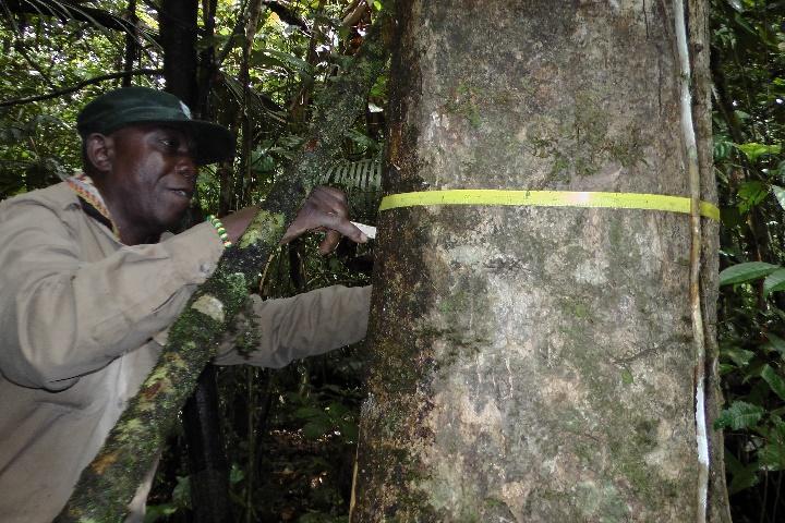
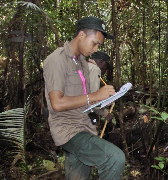
13 Field parameters collected
14 Lessons learnt during pilot NFI project Finding the exact location of the center point of the SUf; The time lapse between the moment of aerial image acquisition and field data collection sometimes resulted in a changed crown cover due to natural causes (windbreak) or other activities (new roads, forestry activities, mining, etc.) in the area; Strengthen community consultation and awareness; Physical establishment of outer border of the plots is necessary; Tree height estimations- estimation of 1 or 2 tree heights; More standardization for tree species determination is needed.

15 Determination of exact location in the field GPS Maps Ortho photos
 Fundraising activities Evaluation of methodology Stratification Plot design Use of multisource data Necessary preparations before complete NFI Standardization of tree species")
16 Next steps Finalization and evaluation of the Pilot project (data processing, analysis and reporting) Preparations towards the complete NFI: Formulate project proposal (Country support within ONF REDD+ project) Fundraising activities Evaluation of methodology Stratification Plot design Use of multisource data Necessary preparations before complete NFI Standardization of tree species recognition; Forest type classification system (with interpretation key for RS and field) Allometric equations Awareness and communication program especially for forest based communities Evaluation of registered field parameters after consultation with stakeholders (towards a multipurpose NFI) Implementation of the NFI
17 Ideas for regional collaboration Establishment and/ or evaluation of allometric equations: Creation of a regional database Exchange of methods implemented in the various countries (incl. capacity building component) Joint publications or scientific research Exchange on tree species determination Photo database Protocol for collection of plant material Field guide and protocol for tree species determination Exchange between the approaches within the region Regional platform for botanists and tree spotters


18
Bangladesh MRV Action Plan
 Bangladesh MRV Action Plan 4th UN-REDD Regional Lessons Learned Workshop National Forest Monitoring Systems for REDD+ Bangkok, Thailand 15-17 October 2013 MRV context of the Country National Forest Inventory
Operational low-cost treewise forest inventory using multispectral cameras mounted on drones
 Operational low-cost treewise forest inventory using multispectral cameras mounted on drones Dr. Eugene Lopatin, Natural Resources Institute Finland, eugene.lopatin@luke.fi, +358 29 532 3002 1 Key challenges/opportunities
Methodologies of tropical forest carbon monitoring: Development and state-of-the-art for REDD+
 Methodologies of tropical forest carbon monitoring: Development and state-of-the-art for REDD+ International Symposium on Southeast Asian Tropical Rain Forest Research related with Climate Change and Biodiversity,
A Case Study on a MRV System for REDD+ in Lao P.D.R.
 International Technical Seminar on REDD+, 16-17 February, 2011, Tokyo, Japan Session 5: R&D Trend about MRV Methods for REDD+ A Case Study on a MRV System for REDD+ in Lao P.D.R. Mitsuru NASU, Ph.D. *
Using the laser technique to address the global challenges. Göran Ståhl Swedish University of Agricultural Sciences
 Using the laser technique to address the global challenges Göran Ståhl Swedish University of Agricultural Sciences Overview of presentation The global challenges and lasers Current and emerging areas of
REDD+ FOR THE GUIANA SHIELD
 REDD+ FOR THE GUIANA SHIELD Third Working Group Meeting April 28th and 29th, 2014 Cayenne, French Guiana Report prepared by Sérgio Milheiras and Sara Svensson, ONF International Project Manager: Marie
INDONESIA: UN-REDD PROGRESS Jakarta, September 14, 2009
 INDONESIA: UN-REDD PROGRESS 2009 DIRECTORATE GENERAL OF FOREST PLANNING MINISTRY OF FORESTRY Jakarta, September 14, 2009 PROGRESS National Climate Change Council Forestry Climate Change Working Group Demonstration
MOLI Science Plan. Forestry and Forest Products Research Institute Yasumasa Hirata
 International Workshop on Vegetation Lidar and Application from Space May 26, 2017 MOLI Science Plan Forestry and Forest Products Research Institute Yasumasa Hirata Current Global Issues Contributions
Using Imagery and LiDAR for cost effective mapping and analysis for timber and biomass inventories
 Using Imagery and LiDAR for cost effective mapping and analysis for timber and biomass inventories Mark Meade: CTO Photo Science Mark Milligan: President LandMark Systems May 2011 Presentation Outline
Developing a new forest resource management database
 Developing a new forest resource management database Barents Forest Forum 8.11. 2007 Henry Schneider Forestry Development Centre Tapio Context Inventories for forest management planning are partly funded
REDD+ for the Guiana Shield Regional Workshop
 ONF International SAS, 45bis avenue de la Belle Gabrielle, 94736 Nogent-sur-Marne Cedex, SIRET : 412 350 514 00029 Proposition commerciale REDD+ for the Guiana Shield Regional Workshop November 16 and
Forest Biomass Change Detection Using Lidar in the Pacific Northwest. Sabrina B. Turner Master of GIS Capstone Proposal May 10, 2016
 Forest Biomass Change Detection Using Lidar in the Pacific Northwest Sabrina B. Turner Master of GIS Capstone Proposal May 10, 2016 Outline Relevance of accurate biomass measurements Previous Studies Project
Terms of Reference REGIONAL SUPPORT TO THE PREPARATION OF ALLOMETRIC EQUATIONS IN THE GUIANA SHIELD
 Terms of Reference REGIONAL SUPPORT TO THE PREPARATION OF ALLOMETRIC EQUATIONS IN THE GUIANA SHIELD REDD+ for the Guiana Shield Regional technical collaboration project Context: REDD+ for the Guiana Shield
ASSESSING THE STRUCTURE OF DEGRADED FOREST USING UAV
 ASSESSING THE STRUCTURE OF DEGRADED FOREST USING UAV STUDY CASE IN YUNGAS CLOUD FOREST, NORTH ARGENTINA Fernando Rossi 1, Andreas Fritz 2, Gero Becker 1, Barbara Koch 2 Albert-Ludwigs-Universität Freiburg
Workshop on Land Cover Land Use Change Nov. 7-9, 2011
 Workshop on Land Cover Land Use Change Nov. 7-9, 2011 Activities for REDD and MRV in Vietnam DO XUAN LAN Department of Science Technology and Environment, Ministry for Agriculture and Rural Development,
Airborne Laser Scanning (ALS) for forestry applications
 for forestry applications") Airborne Laser Scanning (ALS) for forestry applications International School on Lidar Technology 2008 IIT Kanpur, India Norbert Pfeifer + I.P.F.-Team http://www.ipf.tuwien.ac.at/ Christian Doppler Laboratory
Airborne Laser Scanning (ALS) for forestry applications International School on Lidar Technology 2008 IIT Kanpur, India Norbert Pfeifer + I.P.F.-Team http://www.ipf.tuwien.ac.at/ Christian Doppler Laboratory
REMOTE SENSING BASED FOREST MAP OF AUSTRIA AND DERIVED ENVIRONMENTAL INDICATORS
 REMOTE SENSING BASED FOREST MAP OF AUSTRIA AND DERIVED ENVIRONMENTAL INDICATORS Heinz GALLAUN a, Mathias SCHARDT a, Stefanie LINSER b a Joanneum Research, Wastiangasse 6, 8010 Graz, Austria, email: heinz.gallaun@joanneum.at
Terms of Reference MONITORING THE IMPACT OF GOLD MINING ON THE FOREST COVER AND FRESHWATER AT THE GUIANA SHIELD REGIONAL SCALE
 Terms of Reference MONITORING THE IMPACT OF GOLD MINING ON THE FOREST COVER AND FRESHWATER AT THE GUIANA SHIELD REGIONAL SCALE REDD+ for the Guiana Shield Regional technical collaboration project in cooperation
SESSION 2 - Working Groups
 REDD+ FOR THE GUIANA SHIELD Technical Cooperation Project SESSION 2 - Working Groups Sérgio Milheiras & Marie Calmel, ONF International 02 June 2014 3 rd SC meeting - Cayenne, French Guiana Capacity Building
Regional Capacity Building Training Seminars on the Development and Implementation of Climate Mitigation Actions
 Regional Capacity Building Training Seminars on the Development and Implementation of Climate Mitigation Actions Courtyard Marriott, Paramaribo Suriname 23 24 June 2016 Sharing success stories and main
Addressing countries reporting requirements to REDD in FAO Approach to National Forest Monitoring and Assessment
 UNFCCC workshop on Methodological Issues for REDD Tokyo, June 25 27, 2008 Addressing countries reporting requirements to REDD in FAO Approach to National Forest Monitoring and Assessment Mikko Leppanen
Evaluation of forest function using GIS data generated by LiDAR data UC th July 2014 ASIA AIR SURVEY Katsumasa OONO
 Evaluation of forest function using GIS data generated by LiDAR data UC644 15 th July 2014 ASIA AIR SURVEY Katsumasa OONO Back Ground & purpose In Japan, the Regional Forest Plan is planed every five year.
Advancing Indonesian Forest Resource Monitoring Linking the approach from Global to National: Indonesia s experience. Belinda Arunarwati Margono
 Advancing Indonesian Forest Resource Monitoring Linking the approach from Global to National: Indonesia s experience Belinda Arunarwati Margono Outline The context Indonesia NFMS: how it was developed,
Forest data services of the Finnish Forest Centre. Juho Heikkilä, Chief Forest Data Specialist, Lic.Sc. (For.) Lahti, Finland, May 31, 2017
 Lahti, Finland, May 31, 2017") Forest data services of the Finnish Forest Centre Juho Heikkilä, Chief Forest Data Specialist, Lic.Sc. (For.) Lahti, Finland, May 31, 2017 Finland - the most forested land in Europe The population of Finland
Forest data services of the Finnish Forest Centre Juho Heikkilä, Chief Forest Data Specialist, Lic.Sc. (For.) Lahti, Finland, May 31, 2017 Finland - the most forested land in Europe The population of Finland
Use of Aerial Digital Imagery to Measure the Impact of Selective Logging on Carbon Stocks of Tropical Forests in the Republic of Congo
 Report submitted to the United States Agency for International Development Cooperative Agreement No. EEM-A-00-03-00006-00 Use of Aerial Digital Imagery to Measure the Impact of Selective Logging on Carbon
and Land Use Change in the Pan Amazonian forests Project Status Suriname
 Monitoring Deforestation, Land use and Land Use Change in the Pan Amazonian forests Project Status Suriname Regional Workshop on REDD+ MRV implementation and Drivers of Deforestation, Guyana 5 th and 6
Lesson 2: Introduction to Plot Sampling
 Lesson 2: Introduction to Plot Sampling Review and Introduction Lesson 1 focused on taking a big picture approach and dividing your forest into individual management units called stands. The next step
Ontario Forest Resource Inventory. Ontario Ecological Land Classification.
 NRMT 2270, Photogrammetry/Remote Sensing Lecture 8 Ontario Forest Resource Inventory. Ontario Ecological Land Classification. Tomislav Sapic GIS Technologist Faculty of Natural Resources Management Lakehead
STATUS OF REDD+ READINESS IN TOGO. Mid-Term Report. Presentation to FCPF PC24
 STATUS OF REDD+ READINESS IN TOGO République Togolaise Mid-Term Report Presentation to FCPF PC24 PLAN DE PRÉSENATION Phase d investissements 1. TIMELINE OF REDD+ READINESS IN TOGO 2. AUTO-EVALUATION BY
VISualize2012: Climate Change and Environmental Monitoring
 VISualize2012: Climate Change and Environmental Monitoring ESTIMATION OF ABOVE GROUND BIOMASS IN RESTORED JUVENILE MANGROVE STANDS: EVALUATION OF SPECTRAL AND IMAGE DOMAIN OPERATORS UTILIZING AIRBORNE
FORESTS FOR TOMORROW PILOT PROJECT FINAL SYNOPSIS
 FORESTS FOR TOMORROW PILOT PROJECT FINAL SYNOPSIS Identification and prioritization of backlog openings for incremental silviculture investment opportunities using remote sensing techniques Proponent Name:
FOREST COVER MAPPING AND GROWING STOCK ESTIMATION OF INDIA S FORESTS
 FOREST COVER MAPPING AND GROWING STOCK ESTIMATION OF INDIA S FORESTS GOFC-GOLD Workshop On Reducing Emissions from Deforestations 17-19 April 2007 in Santa Cruz, Bolivia Devendra PANDEY Forest Survey of
County- Scale Carbon Estimation in NASA s Carbon Monitoring System
 County- Scale Carbon Estimation in NASA s Carbon Monitoring System Ralph Dubayah, University of Maryland 1. Motivation There is an urgent need to develop carbon monitoring capabilities at fine scales and
Big Databases in forest planning and operations New national lidar campaign in Sweden
 Big Databases in forest planning and operations New national lidar campaign in Sweden NB-Nord workshop Erik Willén Process Manager Digitalization Main research partners: LUKE (FI) Metsäteho (FI) Skogforsk
CLIMATE CHANGE AND PNG FOREST AUTHORITY. SIMON M. SAULEI PNG FOREST RESEARCH INSTITUTE LAE
 CLIMATE CHANGE AND PNG FOREST AUTHORITY SIMON M. SAULEI PNG FOREST RESEARCH INSTITUTE LAE ssaulei@fri.pngfa.gov.pg THE CONTEXT OF THE PRESENTATION How is PNGFA approaching the challengers of Climate Change?
Earth Observation for Sustainable Development of Forests (EOSD) - A National Project
 - A National Project") Earth Observation for Sustainable Development of Forests (EOSD) - A National Project D. G. Goodenough 1,5, A. S. Bhogal 1, A. Dyk 1, R. Fournier 2, R. J. Hall 3, J. Iisaka 1, D. Leckie 1, J. E. Luther
Earth Observation for Sustainable Development of Forests (EOSD) - A National Project D. G. Goodenough 1,5, A. S. Bhogal 1, A. Dyk 1, R. Fournier 2, R. J. Hall 3, J. Iisaka 1, D. Leckie 1, J. E. Luther
FREL for REDD+ Nguyen Dinh Hung, FIPI, Viet Nam GFOI Plenary 2017, Ho Chi Minh City, 12 April 2017
 FREL for REDD+ Nguyen Dinh Hung, FIPI, Viet Nam GFOI Plenary 2017, Ho Chi Minh City, 12 April 2017 FREL overview Final report of TA 2015 - Preparation FREL submitted to UNFCCC Jan. 2016 National FREL submitted
Monitoring Forest Dynamics in Northeastern China in Support of GOFC
 Monitoring Forest Dynamics in Northeastern China in Support of GOFC Principal Investigator: Dr. Guoqing Sun, University of Maryland Co-Principal Investigator: Dr. Darrel L. Williams, NASA s Goddard Space
Quantifying Ecosystem Service and Values of the Urban Forest. David J. Nowak USDA Forest Service Northern Research Station Syracuse, NY, USA
 Quantifying Ecosystem Service and Values of the Urban Forest David J. Nowak USDA Forest Service Northern Research Station Syracuse, NY, USA Overview Ecosystem services Measuring services Top down Bottom
DG of Forestry Planning
 MINISTRY OF FORESTRY Ruandha Agung Sugardiman DG of Forestry Planning Workshop on step-wise approaches for national forest monitoring and REDD+ MRV capacity development Wageningen, The Netherlands 3-5
Methodology for assessing carbon stock for REDD+ project in India
 Methodology for assessing carbon stock for REDD+ project in India The Energy and Resources Institute w w w. t e r i i n. o r g Methodology for assessing carbon stock for REDD+ project in India Suresh
REGIONAL WORKSHOP ON REDD+ MRV IMPLEMENTATION AND DRIVERS OF DEFORESTATION
 REGIONAL WORKSHOP ON REDD+ MRV IMPLEMENTATION AND DRIVERS OF DEFORESTATION Guyana Forestry Commission Guyana, South America December, 2013 Outline of Presentation Background to MRV System Development Developing
THE NATIONAL FOREST INVENTORY IN THE REPUBLIC OF BULGARIA - A RECOGNIZED NEED
 Ministry of Agriculture and Food THE NATIONAL FOREST INVENTORY IN THE REPUBLIC OF BULGARIA - A RECOGNIZED NEED Presentation During the 2 nd International Workshop on Forest Inventory Statistics May 24-26,
INVENTORY? - MEASUREMENTS & - BASIC STATISTICS ARE IMPORTANT FOR PRUDENT FOREST MANAGEMENT
 INVENTORY? - MEASUREMENTS & - BASIC STATISTICS ARE IMPORTANT FOR PRUDENT FOREST MANAGEMENT BY BALOZI AND JARNO Contents What is ArboLiDAR? Input data Sampling and field work Automatic stand segmentation
A Tool To DeTerMIne CroWn AnD PloT CAnoPy TrAnSPArenCy For ForeST InvenTory AnD AnAlySIS PHASe 3 PloTS USInG DIGITAl PHoToGrAPHS
 2010 Joint Meeting of the Forest Inventory and Analysis (FIA) Symposium and the Southern Mensurationists A Tool To DeTerMIne CroWn AnD PloT CAnoPy TrAnSPArenCy For ForeST InvenTory AnD AnAlySIS PHASe 3
DSS 500 with In-FlightOrtho Maximize Your Productivity!
 DSS 500 with In-FlightOrtho Maximize Your Productivity! : DSS 500 maximizes efficiency and productivity in aerial mapping with in-air georeferenced orthophoto production. capture everything. precisely.
Precision forestry in Finland
 Precision forestry in Finland ICT Smart Precision Forestry with Laser Scanning, Finland Japan Joint Symposium (3 rd edition), Tokyo Associate Professor Mikko Vastaranta, School of Forest Sciences, Faculty
Drone Basics 101 Technology, Regulations and Project Examples. Tom Gehrdes & Alton Whittle
 Drone Basics 101 Technology, Regulations and Project Examples Tom Gehrdes & Alton Whittle What are UAVs? Unmanned Aerial Vehicles (UAVs) are remotely operated aircraft that fly without the possibility
Vegetation Resources Inventory
 Vegetation Resources Inventory Guidelines for Preparing a Project Implementation Plan for Ground Sampling Prepared by Ministry of Sustainable Resource Management Resource Information Branch For the Terrestrial
Milne Bay Corridor Planning A systematic conservation planning approach to opportunity cost trade-offs
 Milne Bay Corridor Planning A systematic conservation planning approach to opportunity cost trade-offs Presented at Melanesia CBC Management Team Meeting, Jayapura, Indonesia 12 September 2005 Corridor
Pacific Islands National Forest Inventory for REDD+
 Pacific Islands National Forest Inventory for REDD+ BOOKLET 1: GUIDANCE FOR POLICY MAKERS NFI For Policy Makers Page 1 Copyright etc. Pacific Islands National Forest Inventory for REDD+ Booklet 1: Guidance
Japan s contributions on REDD-plus implementation. Activities of REDD Research and Development Center, FFPRI
 1 2016.7.15 REDD-plus Symposium Japan s contributions on REDD-plus implementation Activities of REDD Research and Development Center, FFPRI Dr. Mitsuo Matsumoto Director General, Hokkaido Research Center
Country Presentation: India
 Country Presentation: India Methodological Issues for REDD Estimation and Monitoring Methodologies for Forest Carbon Stocks Dr Rekha Pai Deputy Inspector General of Forest Ministry of Environment and Forests
REDD+ for the Guiana Shield Terms of Reference for Working Groups
 REDD+ for the Guiana Shield Terms of Reference for Working Groups Context REDD+ for the Guiana Shield A Technical Regional Platform for REDD+ Development in the Guiana Shield is a regional project funded
New Features of Airborne Lidar Data Processing in DTM Generating, Forest Inventory and Civil Engineering Works
 New Features of Airborne Lidar Data Processing in DTM Generating, Forest Inventory and Civil Engineering Works Evgeny Medvedev, Altex Geomatica, Moscow, Russia Contents: About Altex Geomatica 12 years
DETERMINATION OF THE FOREST CANOPY COVER USING A LOW- COST COMMERCIAL DRONE IN A TURKEY OAK AND DURMAST OAK STAND IN THE ZARAND MOUNTAINS, ROMANIA
 DETERMINATION OF THE FOREST CANOPY COVER USING A LOW- COST COMMERCIAL DRONE IN A TURKEY OAK AND DURMAST OAK STAND IN THE ZARAND MOUNTAINS, ROMANIA 12 T. P. BANU 1, G. F. BORLEA 1, C. BANU 1 1 Banat s University
FOREST BIOMASS & CARBON STOCKS MAPPING USING SATELLITE IMAGERIES & ISSUES RELATING TO REDD+ IN MALAYSIA
 FOREST BIOMASS & CARBON STOCKS MAPPING USING SATELLITE IMAGERIES & ISSUES RELATING TO REDD+ IN MALAYSIA Hamdan Omar GeoInformation Programme Division of Forestry and Environment, FRIM Workshop on Methods
Module STR-NFI: Forest Carbon Stratification Using NFI Data
 LEAF TECHNICAL GUIDANCE SERIES FOR THE DEVELOPMENT OF A NATIONAL OR SUBNATIONAL FOREST CARBON MONITORING SYSTEM FOR REDD+ Module STR-NFI: Forest Carbon Stratification Using NFI Data LEAF TECHNICAL GUIDANCE
Weighting Alternative Estimates when Using Multi-Source Auxiliary Data for Forest Inventory
 Poso, Silva Wang Fennica & Tuominen 33(1) research articles Weighting Alternative Estimates when Using Multi-Source Auxiliary Data for Forest Inventory Weighting Alternative Estimates when Using Multi-Source
Land Use/Land Cover Change Research and Management in Vietnam
 NASA-LCLUC Science Team Joint Meeting with MAIRS, GOFCGOLD and SEA START on LC/LU Change Processes in Monsoon Asia Region Jan.12-17, 2009 Land Use/Land Cover Change Research and Management in Vietnam By:
INTEGRATED LAND USE ASSESSMENT PROJECT (ILUA II) CONTRIBUTION TO THE REDD PROCESS IN ZAMBIA
 CONTRIBUTION TO THE REDD PROCESS IN ZAMBIA") INTEGRATED LAND USE ASSESSMENT PROJECT (ILUA II) CONTRIBUTION TO THE REDD PROCESS IN ZAMBIA Biomass Estimation and Forest Cover Mapping Workshop, 20 th June 2011, Kigali, Rwanda Presenters: Sitwala Wamunyima
INTEGRATED LAND USE ASSESSMENT PROJECT (ILUA II) CONTRIBUTION TO THE REDD PROCESS IN ZAMBIA Biomass Estimation and Forest Cover Mapping Workshop, 20 th June 2011, Kigali, Rwanda Presenters: Sitwala Wamunyima
Airborne and Terrestrial Laser Scanning in Forestry
 Airborne and Terrestrial Laser Scanning in Forestry Géza Király 1, Gábor Brolly 1 1 University of West Hungary Faculty of Forestry Department of Surveying and Remote Sensing H-9400 SOPRON, Bajcsy-Zs u.
National Forest Monitoring System Development in Cambodia
 National Forest Monitoring System Development in Cambodia 5 th UN-REDD Regional Lesson Learn Workshop Forest Monitoring System and Reference Levels for REDD+ Hanoi, Vietnam, 20-22 October, 2014 Presented
Vegetation Resources Inventory Localization Procedures
 Vegetation Resources Inventory Localization Procedures Prepared by Resource Information Branch Ministry of Sustainable Resource Management For the Resources Information Standards Committee March 2005 Version
REDD Readiness Progress Fact Sheet COUNTRY: ARGENTINA August 2016
 1. R-PP Preparation and FCPF Readiness grant - Argentina s R-PP was assessed by FCPF PC at PC6 (June 2010), and the Readiness Preparation Grant funding was allocated. - The FCPF FMT confirmed on March
Integration of Alos PalSAR and LIDAR IceSAT data in a multistep approach for wide area biomass mapping
 Integration of Alos PalSAR and LIDAR IceSAT data in a multistep approach for wide area biomass mapping. Above Ground Biomass (carbon) mapping and monitoring: Importance Supporting UNFCC KP, REDD+, Monitoring
5. ANALYSIS OF MRV SYSTEM FOR REDD+
 5. ANALYSIS OF MRV SYSTEM FOR REDD+ 5. Analysis of MRV System for REDD+ 5.1. Objectives of the MRV System The objectives of the MRV (measurement, reporting and verification) system in REDD+ are to measure
Challenges for Improving Forest Inventory Systems to Support Forest Carbon Monitoring in Indonesia
 Challenges for Improving Forest Inventory Systems to Support Forest Carbon Monitoring in Indonesia Presented in International Workshop on Forest Carbon Emission, Jakarta, 4 March 2015 Tatang Tiryana tangtir@apps.ipb.ac.id
ETJIH TASRIAH. BPS-Statistics Indonesia
 SEEA IMPLEMENTATION IN INDONESIA Inter-regional Workshop on Strengthening statistical capacities for building macroeconomic and sustainable development indicators in Latin America, the Caribbean and Asia-Pacific
Readiness Preparation Proposal Suriname. Rene Somopawiro, MSc. October 27 th, 2009 Washington D.C.
 Readiness Preparation Proposal Suriname Rene Somopawiro, MSc. October 27 th, 2009 Washington D.C. 1 LOCATION SURINAME 2 National circumstances Surface area Population (2007) GDP (2007) Percentage ethnic
Appendix II. Growth & Yield Monitoring Plan
 Sundance Forest Industries Ltd. Appendices (Revised) Appendix II. Growth & Yield Monitoring Plan Introduction The Growth & Yield Monitoring Plan has been developed in support of Objectives 22 and 25 of
Sunshine Coast Timber Supply Area
 Sunshine Coast Timber Supply Area Vegetation Resources Inventory Photo Interpretation Project Implementation Plan PREPARED BY: GERRY SOMMERS & WARREN NIMCHUK ISSUED: AUGUST 2005 REVISED: MARCH 2006 1.
Afforestation/Reforestation Afforestation/Reforestation Clean Development Mechanism Projects in Uttar Pradesh State August
 Afforestation/Reforestation Clean Development Mechanism Projects in Uttar Pradesh State August 9, 2014 Suresh Chauhan TERI, New Delhi Presentation outlines 1. Guidelines for preparing Project Design Document
MONITORING LAND USE AND LAND USE CHANGES IN FRENCH GUIANA BY OPTICAL REMOTE SENSING
 MONITORING LAND USE AND LAND USE CHANGES IN FRENCH GUIANA BY OPTICAL REMOTE SENSING Photo : Valéry Gond Photo : Valéry Gond Photo Photo : Gaëlle : : Valéry VERGER Gond Gaëlle VERGER ONF, French National
Progress in REDD+ Preparation in Lao PDR
 Progress in REDD+ Preparation in Lao PDR International Seminar on REDD 10-12 March 2010, Tokyo, Japan Presented by: Dr. Silavanh Sawathvong Director General for Department of Forestry, Lao PDR 1 Contents
MAP PRODUCTION FOR FOREST PLANTATION AREAS IN KOSOVO
 MAP PRODUCTION FOR FOREST PLANTATION AREAS IN KOSOVO Ymer Kuka Mag. Eng. Ymer Kuka University of Prishtina, Faculty of Civil Engineering, Architecture and Geodesy, Department of Geodesy Bregu i Diellit
Implementation of Forest Inventory Throughout Interior Alaska
 US Forest Service & State of Alaska Forest Inventory and Analysis (FIA) Implementation of Forest Inventory Throughout Interior Alaska State of Alaska, Department of Natural Resources, Division of Forestry
K&C Phase 3 Brief project essentials Forest Resources Mapping and Monitoring in Kenya
 K&C Phase 3 Brief project essentials Forest Resources Mapping and Monitoring in Kenya SUZUKI KEI JAFTA(Japan Forest Technology Association) Science Team meeting #16 Phase 3 Kick-off JAXA TKSC/RESTEC HQ,
The Digital Forest. Geospatial Technologies in Urban Forest Management. Justin Morgenroth New Zealand School of Forestry University of Canterbury
 The Digital Forest Geospatial Technologies in Urban Forest Management Justin Morgenroth New Zealand School of Forestry University of Canterbury Why Measure a Tree? Determine annual growth Determine value
Research projects of Landuse changes in Latvia
 Research projects of Landuse changes in Latvia Ilmars Krampis University of Latvia, faculty of Geography and Earth Science Juris Zariņš Latvian State Forest Research Institute "Silava" Joint NASA LCLUC
Forest Assessments with LiDAR: from Research to Operational Programs
 Forest Assessments with LiDAR: from Research to Operational Programs David L. Evans Department of Forestry Forest and Wildlife Research Center Mississippi State University Forest Remote Sensing: Then and
Narration: In this presentation you will learn about various monitoring methods for carbon accounting.
 1 Narration: In this presentation you will learn about various monitoring methods for carbon accounting. 2 Narration:The presentation is divided into four sections. 3 Narration: USAID s standard climate
Monitoring carbon emissions from forest degradation for REDD
 Global Observation of Forest and Land Cover Dynamics Monitoring carbon emissions from forest degradation for REDD Martin Herold GOFC-GOLD Land Cover Office, FSU Jena, Germany www.gofc-gold.uni-jena.de
Appendix II. Growth & Yield Monitoring Plan
 Sundance Forest Industries Ltd. Appendices (Revised) Appendix II. Growth & Yield Monitoring Plan Introduction The Growth & Yield Monitoring Plan has been developed in support of Objectives 22 and 25 of
K&C Phase 3 Brief project essentials
 K&C Phase 3 Brief project essentials Aboveground Biomass and Carbon Stock Mapping and Changes Monitoring in the Forest of Peninsular Malaysia Using L-Band ALOS Palsar and JERS-1 Khali Aziz Hamzah & Hamdan
Experiences and requirements for biomass mapping. Martin Herold. Wageningen University. Biomass CCI 1. User Meeting 25/26. Sept.
 Experiences and requirements for biomass mapping Martin Herold Wageningen University Biomass CCI 1. User Meeting 25/26. Sept. 2018 in Paris Need for biomass information is growing and diversifying Climate
Session 1 implementation. We construct our national FREL with the following principles: transparency, accuracy, completeness, consistency, and compara
 FREL and REDD+ in Indonesia Novia Widyaningtyas (Ministry of Environment and Forestry, Indonesia) Session 1 FREL and REDD+ in Indonesia Novia Widyaningtyas (Ministry of Environment and Forestry, Indonesia)
Drones Use in Forestry: Regulations, Applications, Considerations
 Drones Use in Forestry: Regulations, Applications, Considerations Regulations What is a Drone? Small unmanned aircraft system aka UAV, UAS, suas. Weight is greater than 0.5 lbs. and less than 55 lbs. including
FGI meeting May 12, Hyytiälä experiment projects
 FGI meeting May 12, 2009 Hyytiälä experiment 2008 2011 projects Ilkka Korpela Department of Forest Resource Management, University of Helsinki Faculty of Forest Sciences, University of Joensuu Ilkka.korpela@helsinki.fi
Airship-based LiDAR and multi-sensor forest monitoring
 Airship-based LiDAR and multi-sensor forest monitoring S. Esposito, P. Fallavollita, M. Balsi, R. Tognetti, M. Marchetti COST WORKSHOP Green Engineering Camp ( GEC) Plitvice Lakes National Park, Croatia
Forest change detection and monitoring using passive and active remote sensing data (RS4FOR project)
") Forest change detection and monitoring using passive and active remote sensing data (RS4FOR project) Katarzyna Staszyńska, Ewa Grabska, Anna Zielonka, Katarzyna Ostapowicz Institute of Geography and Spatial
Forest change detection and monitoring using passive and active remote sensing data (RS4FOR project) Katarzyna Staszyńska, Ewa Grabska, Anna Zielonka, Katarzyna Ostapowicz Institute of Geography and Spatial
REDD+ for the Guiana Shield. Terms of Reference for the regional database on drivers of deforestation/degradation
 REDD+ for the Guiana Shield Technical and regional platform for the development of REDD+ in the Guiana Shield Terms of Reference for the regional database on drivers of deforestation/degradation Project
Unmanned Aerial Vehicle (UAV) Inspection, survey, mapping, modelling & analysis
 Inspection, survey, mapping, modelling & analysis") Unmanned Aerial Vehicle (UAV) Inspection, survey, mapping, modelling & analysis Opus have utilised our own UAV fleet since 2007. They are one of a range of technologies used to enhance our core services.
Unmanned Aerial Vehicle (UAV) Inspection, survey, mapping, modelling & analysis Opus have utilised our own UAV fleet since 2007. They are one of a range of technologies used to enhance our core services.
Integration of forest inventories with remotely sensed data for biomass mapping: First results for tropical Africa
 Integration of forest inventories with remotely sensed data for biomass mapping: First results for tropical Africa Alessandro Baccini Nadine Laporte Scott J. Goetz Mindy Sun Wayne Walker Jared Stabach
Alpine Safety, Security & Informational Services and Technologies
 Alpine Safety, Security & Informational Services and Technologies Alexander Almer, Thomas Schnabel, Manuela Hirschmugl, Klaus Granica, Johann Raggam (JOANNEUM RESEARCH) Michael van Dahl (VCS) Alexander
Tel No List of Annexes: Annex 1-Work agenda Suriname- Costa Rica- Suriname
 Organization/ Institution: Stichting voor Bosbeheer en Bostoezicht (SBB) Centrum voor Landbouwkundig Onderzoek in Suriname (CELOS) Nationale Zoologische Collectie Suriname (NZCS) Name Charlene Sanches
Wood supply digitalization in Finland
 Wood supply digitalization in Finland Jarmo Hämäläinen Metsäteho Oy Industrial Scale Bioeconomy and its Requirements conference June 14th 16th 2017 Lappeenranta, Finland Vision: Efficient Wood Supply 2025
Mule Deer Winter Range Planning. Current And Future Forest Condition Pilot Project. Submitted to:
 Mule Deer Winter Range Planning Current And Future Forest Condition Pilot Project Submitted to: Ministry of Sustainable Resource Management Cariboo Region March, 2003 FIRS Project # 1029-16 Professional
Airborne LiDAR Scanning for Forest Biomass Estimation
 Airborne LiDAR Scanning for Forest Biomass Estimation M. Balsi, S. Esposito, P. Fallavollita, C. Giannì DIET, La Sapienza University, Rome, Italy Oben srl, Sassari, Italy - www.oben.it marco.balsi@uniroma1.it
SFM Indicator 2 Key Sub-Indicator Field Monitoring Procedures
 SFM Indicator 2 Key Sub-Indicator Field Monitoring Procedures Prepared for: Pope & Talbot Ltd. Prepared by: Phil MacDonald, RFT & Dennis Hamilton, RPBio. March 31, 2006 Background An important component