Flood Mitigation Action Plan. Town of Avoca, Town of Bath, and Village of Bath
|
|
|
- Lewis Morris
- 6 years ago
- Views:
Transcription
1 Flood Mitigation Action Plan Town of Avoca, Town of Bath, and Village of Bath April 2001
2 Flood Mitigation Action Plan Town of Avoca, Town of Bath, and Village of Bath Steuben County, New York April 2001 Prepared with assistance from: Southern Tier Central Regional Planning and Development Board 145 Village Square Painted Post, NY This Flood Mitigation Action Plan was prepared as part of the Southern Tier Central Flood Mitigation Planning Project, which was funded in part by the New York State Emergency Management Office and Federal Emergency Management Agency.
3 Table of Contents page Background 1 How This Plan Was Prepared 3 Public Involvement 4 Coordination with Relevant Agencies 5 Procedure for Review and Revision of the Plan 7 Flood Hazards and Problems 8 Riverine Flooding and Bank Erosion 8 Stormwater Runoff 24 Flood Warning 28 Development Activities 29 Flood Mitigation Goals 30 Public Information 31 Preventive Measures 31 Natural Resource Protection 31 Property Protection 31 Structural Solutions 31 Flood Mitigation Solutions 32 Action Plan 33 Public Information 33 Preventive Measures 34 Natural Resource Protection 35 Property Protection 35 Emergency Services 36 Post-Disaster Mitigation Policies And Procedures 38 ATTACHMENT A: Documentation of Public Involvement ATTACHMENT B: Maps of Flood Hazards and Problems Summary of Flooding Problems ATTACHMENT C: State Permitted Dams in Avoca and Bath ATTACHMENT D: Flood Solutions Worksheet
4 BACKGROUND The Towns of Avoca and Bath are located in north central Steuben County, New York. The Village of Bath is the county seat and is located within the Town of Bath. These three municipalities have a combined population of 13,036 (1990 census: Town of Avoca 1,236; Town of Bath 5,999; Village of Bath 5,801). Most of the development in Avoca and Bath is concentrated in the broad, flat valley of the Cohocton River, which flows southeastward through the area. The Town of Avoca, Village of Bath, and most of the Town of Bath are within the Cohocton River Basin, which is part of the Chesapeake Bay Watershed. An area north of the Village of Bath (in the Town of Bath) drains northeastward into Keuka Lake (a Finger Lake of the Oswego River Basin). The principle source of flooding in Avoca and Bath is the Cohocton River. Concentrated development in the Villages of Bath and Avoca is protected by levees and floodwalls. Other development in the Cohocton River Valley is not protected by any man-made flood control structures. Some natural protection is provided by riverine wetlands, which store floodwater and retard flow. Additional flood and erosion hazards occur along tributary streams and other drainage ways. The area contains many steep, flashy streams located in narrow gullies. There are numerous sites that experience flooding and streambank erosion problems. The most recent flooding in Avoca and Bath has resulted from heavy rainfall during localized thunderstorms, particularly during July 1998 (FEMA 1233-DR-NY) and June Roadways and roadside drainage structures have been severely damaged by these events. The most recent Cohocton River flooding occurred on January 19, 1996, when river water inundated homes and businesses with as much as 4 feet of water (FEMA 1095-DR-NY). The flood of record for the Cohocton River is the Finger Lakes Flood in July 1935, which had a discharge more than two times that of the January 1996 flood (measured downstream at the Cohocton River Gauge near Campbell). Additional flooding has occurred in May 1946 (intense rainfall on previously saturated ground), June 1972 (Hurricane Agnes Flood), September 1975 (Hurricane Eloise Flood), June 1976 ( Fathers Day Flood ), February 1977 (ice jams caused localized flooding in Bath), September 1977 (heavy rain with isolated flooding in Kanona and Bath), August 1984 (thunderstorms caused severe flooding in western Steuben County), and March 1993 (spring melt led to evacuations in Avoca and Kanona). In addition to these major flood events, many additional incidents have caused localized drainage problems, ponding, streambank erosion and other difficulties. The Town of Avoca, Town of Bath, and Village of Bath all joined the National Flood Insurance Program in Since that time, development within the areas designated as the 100-year floodplain (on the Town and Village Flood Insurance Rate Maps) has been regulated by local ordinances. The Town of Avoca has adopted the most recent New York State Model Law for Flood Damage Prevention and incorporated a requirement that structures be elevated to two feet above the predicted height of 100-year flooding (two feet higher than the level of protection 1
5 required by the National Flood Insurance Program). Flood insurance can be purchased for any building in Avoca or Bath. On March 3, 1999, there were 15 flood insurance policies in the Town of Avoca (12 in the 100-year floodplain), 35 policies in the Town of Bath (29 in the 100-year floodplain), and 5 policies in the Village of Bath (1 in the 100-year floodplain). Flood insurance claims since 1978 have totaled $155,609 (9 claims in the Town of Avoca, 24 claims in the Town of Bath, and 1 claim in the Village of Bath). This represents only a fraction of the total flood damages because many property owners do not carry flood insurance and many damages (particularly to basements and basement contents) are not covered. The National Flood Insurance Program classifies one property in the Town of Avoca as repetitive loss property, indicating that it has experienced two or more flood insurance claims within any ten-year period. This property is located within the area described in this Plan as Flood Problem #16. The property is currently condemned and is unlikely to be restored. The Bath Volunteer Fire Department began training a Swiftwater Rescue Team in This team currently consists of trained Swiftwater Rescue Technicians and Swiftwater First Responders. The department and team members have purchased many pieces of equipment for shore based, boat based, and in-water rescues. This equipment includes a boat for flood and swiftwater rescue and another boat for flood evacuation situations. In the past few years, the Swiftwater Rescue Team has been involved in several flood situations, including boat-based evacuations in Bath and Kanona. Members of several other fire departments serving Avoca and Bath have also received training in basic swiftwater rescue techniques and have purchased life vests and other equipment. The Town of Avoca, Town of Bath, and Village of Bath benefit from many ongoing efforts to resolve flooding and drainage problems. When road, shoulder, culvert, and road ditch repairs have been necessary, efforts have been made to address the problems rather than just repairing the damage. The Highway Departments have replaced drainage pipes with larger structures to accommodate increased flow from changing land use patterns. The County Soil and Water Conservation District has worked closely with the Towns and property owners to implement stream maintenance and stabilize sites experiencing streambank erosion. The County Emergency Management Office is improving the flood warning and emergency response capabilities by expanding the existing network of precipitation and river level gauges. This Plan represents an attempt on the part of these municipalities to identify and implement measures that will further reduce flood damages. 2
6 HOW THIS PLAN WAS PREPARED This Plan was prepared at a series of flood mitigation planning meetings. Participants included: Bath Town Supervisor, Avoca Town Supervisor, Town of Bath Councilmen, Town of Bath Planning Board members, Town of Bath Code Enforcement Officer, Village of Bath Code Enforcement Officer, Town of Avoca Code Enforcement Officer, Town of Bath Highway Superintendent, Town of Avoca Highway Superintendent, Steuben County Soil and Water Conservation District, Steuben County Emergency Management Office, Steuben County Commissioner of Public Works, NY State Regional Flood Control Engineer (Department of Environmental Conservation), NY State Department of Transportation, property owners from the Town of Avoca, and property owners from the Town of Bath. The Flood Mitigation Specialist for Southern Tier Central Regional Planning and Development Board provided staff support. All decisions were reached by consensus of those present. The information and recommendations included in this Plan were assembled at a series of flood mitigation planning meetings. The Southern Tier Central Flood Mitigation Specialist documented the proceedings of each meeting for review at subsequent meetings. The following meetings were held: 10/14/99: Organizational meeting: Introduction to the flood mitigation planning process. Identify planning committee members. Develop a strategy for coordinating with other agencies and elected officials. Develop a strategy for involving the public. Define the scope of the planning process. Discuss flooding problems and related issues. 10/26/99: Assess hazards and problems, Village of Bath: Compile information about flood hazards in the Village of Bath. Identify flood problem areas and document the nature of the problems. Discuss the substantial improvement requirements for floodplain development. 11/1/99: Assess hazards and problems, Town of Avoca: Compile information about flood hazards in the Town of Avoca. Identify flood problem areas, document the nature of each problem, and mark flood problem areas on a map for digitizing. Discuss the Hazard Mitigation Grant Program and flood insurance. 11/4/99: Assess hazards and problems, Town of Bath: Compile information about flood hazards in the Town of Bath. Identify flood problem areas, document the nature of each problem, and mark flood problem areas on a map for digitizing. Discuss the Hazard Mitigation Grant Program. 12/2/99: Set flood damage reduction goals: Update on the responses received from agency personnel and elected officials. Review other community goals. Discuss the committee s vision of how flooding issues can be addressed and future damages prevented. Compile a list of flood damage reduction goals for Avoca and Bath. Discuss floodplain and floodway development requirements. 2/17/00: Evaluate Flood Solutions: Review and revise the proposed flood mitigation goals. Begin reviewing the Flood Solutions Worksheet a comprehensive list of possible activities for reducing flood damages. Identify public information and preventive activities that are 3
7 applicable to the resolution of flooding problems in the Town of Avoca, Town of Bath, and Village of Bath. Discuss sites at which debris accumulation and flooding problems impact the residents attending the meeting. Discuss development requirements within the regulatory floodway. 3/16/00: Evaluate Flood Solutions: Review the sections of the Flood Solutions Worksheet that encompass preventive activities, natural resource protection, property protection, structural projects, and emergency services. Identify activities that are applicable to the resolution of flooding problems in Avoca and Bath. 4/26/00: Prepare an action plan: Review the completed Flood Solutions Worksheet. Using this worksheet and the committee s flood mitigation goals, prepare an action plan of activities for implementing the proposed solutions. Recommend post-disaster mitigation policies and procedures. Develop a strategy for implementation, evaluation, and revision of the Plan. Recommendation for public review of the draft Plan. PUBLIC INVOLVEMENT The chronic nature of flooding problems in Avoca and Bath has led to interactions between residents and municipal officials concerning water management issues. Additional interactions have revolved around the enforcement of floodplain development standards in regulated floodplain and floodway areas. This public input has occurred at municipal board meetings, planning board meetings, and through a variety of other forums. The problems and potential solutions arising from these ongoing interactions were incorporated into this flood mitigation planning process. Additional public input was obtained throughout this planning process. Information about the flood mitigation planning effort was posted in municipal offices (copy in Attachment A) and meetings were announced in the local press. A newspaper article midway through the planning process provided additional publicity (clipping in Attachment A). In addition, municipal officials personally contacted owners of flood prone property and invited them to attend meetings. Approximately 10 residents attended one or more flood mitigation planning meeting. A draft of this Plan was presented at two public information meetings on June 13, 2000 in Bath and on June 15, 2000 in Avoca. These meetings were publicized through local newspapers (clippings in Attachment A), notices posted in public areas, direct mailing (to municipal officials, agency personnel, and elected officials), and word of mouth. Attendance at these meetings included: citizens, municipal officials, County Soil and Water Conservation District staff, and a representative of the New York State Assemblyman. Each public meeting included a presentation of the planning process and the proposed action items followed by discussion of flooding issues, concerns, and mitigation measures. Large-format copies of the Flood Hazard and Problem Maps (Attachment B) were displayed for review and discussion. Each participant was given a handout summarizing the flood mitigation planning process (included in Attachment A) and a list of the proposed action items (Table 1 in this Plan). Copies of the entire Plan were available for review. 4
8 At the public meeting in Bath, concerns were expressed about the accuracy to the Flood Insurance Rate Maps and Flood Boundary and Floodway Maps for the Town of Bath. Some residents desire the expenditure of public funding for elevation surveys to evaluate the accuracy of these maps. However, Town Board representatives indicated that the Town Board had discussed this issue and decided to wait for the re-mapping planned by the New York State Department of Environmental Conservation (with funding from the Federal Emergency Management Agency). Town of Bath officials indicated that they are committed to enforcement of National Flood Insurance Program regulations for floodplain development, despite local opposition by some property owners. Failure to enforce these regulations could result in suspension from the National Flood Insurance Program and a consequent inability to purchase flood insurance (which is required to obtain a federally-backed mortgage for any building located in the 100-year floodplain). The Town of Avoca meeting included a discussion of localized flooding during May 2000 and on June 12, 2000, which impacted several areas in the Town. Flood problem areas #99 and 100 were subsequently added to this Plan. The descriptions of Problems #55, 59, 61, and 101 were revised to include recent damages (and additional damages that occurred on June 15, 2000). The description of Problem #18 was revised based on a telephone conversation with a resident who was unable to attend the meeting. Most of those attending the public meetings were supportive of this Plan. It was recommended that the Town of Bath be added to Action Item #16, Apply for Community Rating System Classification. The Town of Avoca recommended the addition of Action Item #14, Sponsor Grant Applications for Private Floodproofing Projects. A participant from the Town of Avoca volunteered to maintain a rain gauge, consistent with Action Item #24. COORDINATION WITH RELEVANT AGENCIES Flood mitigation planning information was provided to municipal boards and planning boards throughout the planning process. Input from Town officials unable to attend flood mitigation planning meetings was obtained through personal communications, thus insuring consistency with other community goals and activities. A draft of this Flood Mitigation Action Plan was submitted to Town officials for review and comments. County, regional, and state agencies and elected officials were contacted for relevant information and recommendations about this flood mitigation planning effort. Personnel from these agencies attended planning meetings, provided information, answered questions, reviewed minutes, and reviewed draft sections of this document. A letter was sent to each of the following agencies and offices at the beginning of the planning process. Their responses and contributions are summarized below: Steuben County Soil & Water Conservation District attended meetings, provided information about channel maintenance and stabilization, reviewed minutes and draft sections of Plan, responded to questions Steuben County Emergency Management Office attended meetings, provided 5
9 information about flood warning and emergency response, reviewed minutes and draft sections of Plan, responded to questions Steuben County Planning Department (County Hazard Mitigation Coordinator) reviewed minutes and draft sections of Plan Steuben County Public Works Department attended a meeting, provided written recommendations, reviewed minutes and draft sections of Plan Cornell Cooperative Extension of Steuben County responded that they did not have relevant information, staff unable to participate Cohocton River Chapter of Trout Unlimited Environmental Emergency Services, Inc. attended meetings, provided information about gauges and flood warning capabilities Southern Tier Central Regional Planning and Development Board facilitated meetings, wrote minutes, provided information, made recommendations, drafted Plan Sullivan Trail Resource Conservation and Development Council New York State Emergency Management Office, Mitigation Branch reviewed minutes and draft sections of Plan New York State Department of Environmental Conservation, Flood Control attended a meeting, provided information about floodplain development regulations, reviewed minutes and draft sections of Plan, responded to questions New York State Department of Environmental Conservation, Wildlife Management New York State Department of Transportation attended a meeting, provided information about state roads, reviewed minutes and draft sections of Plan USDA Natural Resources Conservation Service U.S. Army Corps of Engineers, Planning Division provided information about Corps of Engineers projects and studies New York State Senator John R. Kuhl, Jr. written response, referred to Soil and Water Conservation District for additional information New York State Assemblyman James G. Bacalles written response, provided information about flood problem areas U.S. Congressman Amory Houghton, Jr. responded that they did not have information to contribute, staff requested and reviewed minutes of meetings A draft of this Flood Mitigation Action Plan was submitted to the following departments and agencies for additional review and comment. Reviewers provided additional information about flood problem areas and recommended solutions. All of the recommendations received were incorporated into this plan. Steuben County Soil & Water Conservation District Steuben County Emergency Management Office Steuben County Planning Department (County Hazard Mitigation Coordinator) Steuben County Public Works Department Cornell Cooperative Extension of Steuben County Environmental Emergency Services, Inc. Southern Tier Central Regional Planning and Development Board Sullivan Trail Resource Conservation and Development Council 6
10 New York State Emergency Management Office, Mitigation Branch New York State Department of Environmental Conservation, Flood Control New York State Department of Transportation Federal Emergency Management Agency USDA Natural Resources Conservation Service PROCEDURE FOR REVIEW AND REVISION OF THE PLAN The Flood Mitigation Action Plan for the Town of Avoca, Town of Bath, and Village of Bath will be reviewed and updated at an annual meeting of Town and Village officials and interested members of the public. The following people will be asked to participate in this process: Municipal Board members, Planning Board members, Highway Superintendents, Code Enforcement Officers, Fire Chiefs, owners of flood-prone property, and representatives of County and State agencies. If possible, the Southern Tier Central Flood Mitigation Specialist will facilitate these meetings. 7
11 FLOOD HAZARDS AND PROBLEMS Flood hazards occur in areas that are prone to flooding, whether or not any development is affected. This Plan addresses the following hazards throughout the Town of Avoca, Town of Bath, and Village of Bath: riverine flooding (from streams), lakeshore flooding, stormwater runoff, and erosion of streambanks. Flooding can result from heavy rainfall, rapid snowmelt, and ice jams. Flash flooding is common on tributary streams. The Flood Insurance Rate Maps for each municipality indicate the areas expected to be inundated by 100-year flooding along the principle water bodies (Attachment B). Additional hazards due to flooding and bank erosion exist along every stream and many unmapped drainage ways. The hazard areas for overland flooding and ponding are generally not recognized unless they contribute to flooding problems. The drainage associated with roadways and roadside ditches poses hazards in many areas, particularly on steep hillsides. The potential hazard areas are thus widespread. Flood problems occur when development is adversely impacted by flood hazards. Numerous flood problem areas have been identified throughout the three municipalities. These problems are described below and indicated on the Maps of Flood Hazards and Problems (Attachment B). This information about flooding problems was assembled from previous documentation and the knowledge of municipal officials, residents, and agency personnel familiar with flooding in Avoca and Bath. RIVERINE FLOODING AND BANK EROSION Riverine flooding occurs when streams and rivers overflow their banks and inundate adjacent valleys. This occurs when heavy rainfall or rapid snowmelt produces water runoff that exceeds the carrying capacity of the channel. Riverine flood damages can be triggered or exacerbated by constriction or obstruction of stream and river channels. This blockage can result from beaver activity, undersized drainage structures, debris dams, ice jams, or accumulation of sediment within the channel. Backwater flooding occurs when a stream is unable to flow into a larger stream or lake due to high water in the downstream water body. The Flood Insurance Rate Maps (FIRMs) for each municipality identify the areas expected to be inundated by the 100-year and the 500-year flood on the Cohocton River and the major streams. The 100-year floodplain delineates the predicted extent of flooding by an event with a 1% chance of being equaled or exceeded during any given year. Many areas within the 100-year floodplain are susceptible to more frequent flooding. The 500-year floodplains correspond to a flood with a 0.2% chance of annual occurrence. The FIRMs also indicate the expected water elevations for the 100-year flood in some areas. Flood profiles and supporting documentation are provided in the Flood Insurance Study. Development within the 100-year floodplain is regulated by local law. Much of the development currently at risk in these areas was constructed prior to adoption and enforcement 8
12 of these regulations. The floodplain development standards are intended to insure that new development in these areas is protected from flood damages and does not cause damage to other areas. In order to insure that floodplain development does not cause major increases in the height of flooding, the central part of the floodplain is reserved for the conveyance of floodwater. This area is called the regulatory floodway and has stricter development standards than those in the floodplain fringe areas. It should be noted that the hydraulic analyses used to delineate floodplains on the FIRMs were based on the assumption of unobstructed flow. The floodplains and flood elevations indicated on these maps are thus considered valid only if all channels and drainage structures remain unobstructed, operate properly, and do not fail. If these conditions do not exist, the impact of 100-year flooding could be greater. The potential for flooding of the numerous smaller streams in Avoca and Bath was not evaluated when the Flood Insurance Rate Maps were prepared. Yet these streams have floodplains and pose flood hazards. Because there is no floodplain designated on the FIRMs, development along these streams is not regulated by the local laws for flood damage prevention. Development near these streams can be at risk from both flooding and streambank erosion. Flood damages can also result from failure of dams, levees, berms, or beaver dams. The Towns of Avoca and Bath contain 12 dams that are permitted by the state. A list of these statepermitted structures and a map showing their locations is included in Attachment C. All of these dams are classified as low hazard due to the limited potential for downstream damages if failure occurs. Most of these structures are more than 30 years old (11 were completed between 1952 and 1968) and none have been recently inspected by a State Dam Safety Engineer. No unsafe conditions are known or suspected. Erosion of streambanks and the subsequent deposition of eroded materials are major concerns in Avoca and Bath. The severity of these problems is due, in part, to the widespread occurrence of poorly consolidated glacial deposits, which are particularly susceptible to erosive forces. In addition, the high gradients of streams flowing down steep slopes provide the energy needed for erosion and transport of bank materials. Natural erosional processes are accelerated during flood events. Accelerated erosion of banks loosens large volumes of material that are subsequently deposited within stream channels. Although bank erosion and channel migration are natural processes, they can be accelerated by human activities. GENERAL PROBLEMS: 1. Streambank erosion: Channel instability poses serious problems for many streams throughout Avoca and Bath. Existing and potential streambank erosion problems threaten all types of development: buildings, farms, yards, roads, bridges, septic systems, pipelines, etc. Severe bank erosion degrades riparian and aquatic habitat. Streambank erosion also leads to deposition of large volumes of sediment, trees, and debris within creek channels, seriously limiting their carrying capacity and increasing the risk of flooding. 2. Debris accumulation in channels: The accumulation of trees and other debris within stream and river channels contributes to flooding problems throughout Avoca and Bath. This debris results from natural processes, streambank erosion (which undermines trees and other 9
13 vegetation), timber harvesting operations, and dumping of material in the channel or floodplain. This material can form debris dams that impede the flow of water, particularly at culverts and bridges. When water bypasses impediments, it erodes streambanks, damages drainage structures, and floods adjacent areas. The impaired flow of water in debris-choked streams contributes to significant amounts of damage every year. 3. Sediment accumulation in channels: The accumulation of sediment within stream channels limits the capacity to convey water and can contribute to flooding of floodplain areas and bridges. The majority of this sediment is eroded from stream banks or streambeds as a result of channel instabilities. Additional sediment results from the erosion of road ditches and banks. Sediment loading also results from inappropriate erosion and sediment control practices at development sites, timber harvesting operations, and agricultural operations. Cohocton River (Town of Avoca, Town of Bath, and Village of Bath) The Cohocton River flows southeastward through Avoca and Bath, providing the primary drainage for the region. Interstate Highways 390 and 86 follow the valley. The broad, fertile valley of the Cohocton River consists primarily of agricultural development and dispersed residential properties. Concentrated development is located within the Cohocton River floodplain in the hamlets of Wallace, Bloomersville, and Kanona and the Villages of Avoca, Bath, and Savona. Development in the Villages of Avoca and Bath is protected by flood control levees built by the U. S. Army Corps of Engineers. These levee systems provide protection against flood discharges larger than the greatest on record, which occurred in July The Bath Flood Protection Project was altered extensively during the construction of Highway 17 (now Interstate 86), with the highway replacing sections of the levee system. The New York State Department of Environmental Conservation maintains these flood protection structures. There are no flood control dams in the Cohocton River basin. Riverine wetlands in the upper part of the watershed provide some natural flood protection by retarding the flow of water through these areas. The Flood Insurance Rate Maps for the Town of Bath, Village of Bath, and Town of Avoca delineate the regulated 100-year floodplain for the Cohocton River. Detailed methods were used for this delineation upstream of the confluence with Stocking Creek in the Town of Bath (approximately 0.5 mile downstream of the Babcock Hollow Road bridge). Where detailed methods were used, the Regulatory Floodway is delineated within the 100-year floodplain, the anticipated height of 100-year flooding is provided, and the 500-year floodplain is delineated. Development in the Cohocton River Valley has repeatedly experienced flooding from the River. The flood of record for the Cohocton River in Campbell occurred in July 1935, during the Finger Lakes Flood. Flooding from Tropical Storm Agnes (June 1972) inundated a wide area of residential, commercial, and agricultural land (with soil erosion and crop loss accounting for a major portion of the damage). The hamlet of Kanona experienced as much as 4 feet of water within some buildings during the 1972 flood. The most recent serious flooding of the Cohocton River occurred during the January 1996 snowmelt. During this flood, the southern portion of the hamlet of Kanona was again inundated. 10
14 Lake Salubria is a 58-acre lake located east of the Village of Bath. Lakeside residents have not experienced any flooding problems since an outlet pipe was installed to allow overflow into the Cohocton River. PROBLEM AREAS: 4. Interstate 86 (3 sites in the Town of Bath and Town of Avoca): State Route 17/Interstate 86 follows the Cohocton River Valley through the Town of Bath and the southeastern part of the Town of Avoca. The roadway is elevated above the predicted height of 100-year flooding in most places. The portions of the highway located within the mapped 100-year floodplain include: eastbound ramps at Exit 39 (Babcock Hollow Road, County Route 11), west of the Village of Bath (in the vicinity of Harrisburg Hollow Creek), and near the River crossing in eastern Avoca (west of the interchange with Interstate 390). 5. Eagle Valley Road (Town of Bath): In , the U.S. Army Corps of Engineers evaluated an erosion problem on the south bank of the Cohocton River, adjacent to Eagle Valley Road. Their Reconnaissance Report provided design recommendations for erosion protection, but concluded that a federal project was not warranted. Rock riprap was subsequently installed to protect the road. 6. Scudder Road (Town of Bath): Two houses located on Scudder Road are located within the 100-year floodplain of the Cohocton River. No detailed study was done to determine the location of the floodway or the anticipated height of 100-year flooding in this area. Sections of the riverbank have been protected with riprap. 7. Babcock Hollow Road area (Town of Bath): One house on Babcock Hollow Road is located within the 100-year floodplain of the Cohocton River; 4 houses are within the 500-year floodplain. Babcock Hollow Road and Eagle Valley Road are also subject to flooding. 8. Delaware Avenue (Village of Bath): An area of ponding east of Delaware Avenue is delineated as 100-year floodplain. Flooding of this area would impact residential yards, but no houses. 9. West Belfast Street area (Town of Bath, Village of Bath): The 100-year floodplain for the Village of Bath includes one business and three houses on West Belfast Street, West Street, and Avenue A. In addition, twelve homes and two businesses are located within the 500- year floodplain. Adjacent areas in the Town of Bath include 6 houses located within the 100- year floodplain and floodway of the Cohocton River. A portion of the land encompassed by the Veterans Administration Center also lies within the floodplain. The Flood Insurance Study for the Town of Bath (November 2, 1982) indicates that the railroad bridge and the Belfast Street bridge intensify flood problems in this area. These bridges constrict the flood flow, thus forcing the waters out of the channel. 10. Longwell Lane (Town of Bath): Approximately 8 houses on Longwell Lane and 2 buildings in the Veterans Administration Center are located within the 500-year floodplain of the Cohocton River. 11. Spaulding Road area (Town of Bath): Immediately west of the Village of Bath, State Route 415 and parts of Spaulding Road are located within the 100-year floodplain of the Cohocton River. Approximately 20 houses, 7 businesses, and a State Police Station are located within the 100-year floodplain. Most of this development is in the area southeast of Harrisburg Hollow Creek, where an earthen berm provides some flood protection. 12. Knight Settlement Road bridge (Town of Bath): Gravel shoals under the Knight Settlement Road bridge (County Route 15) have obstructed flow under one span of the bridge. The 11
15 County has recently removed gravel from this site to facilitate the flow of high water and plans to complete this project in Route 415 east of Kanona (Town of Bath): Route 415 is located within the floodway portion of the 100-year floodplain between Knight Settlement Road (County Route 15) and the hamlet of Kanona (State Highway 53). Floodway development includes approximately 25 homes and half a dozen businesses. This area has experienced water along the road and in the yards and basements of at least one business and a dozen houses in recent years. A mobile home that experienced first floor flooding has been removed. 14. Kanona (Town of Bath): The hamlet of Kanona is located on the northeast bank of the Cohocton River at the confluence with Fivemile Creek. The south side of the hamlet includes approximately 25 houses, 3 businesses, a church, and a Post Office that are located within or near the 100-year floodplain. More than half of this floodplain development is located within the floodway of the Cohocton River. Approximately 5 additional homes are within the 500-year floodplain. The hamlet has experienced repeated flooding that affects the living space of numerous houses. The Flood Insurance Study for the Town of Bath (November 2, 1982) reports flood damage in Kanona during the floods of 1935, 1972, and Water was reportedly about 4 feet deep within the church in June 1972 and in January A restaurant and additional houses have experienced basement flooding. The Town of Bath has applied for grant funding (from the New York State Clean Water/Clean Air Bond Act) for a channel restoration project in this area. If implemented, the proposed project will stabilize the channel and banks of the Cohocton River and improve fish habitat, but will not solve the flooding problems. 15. Route 415 and Campbell Creek Road (Town of Bath): Development southwest of the Cohocton River on State Route 415 and Campbell Creek Road (County Route 14) includes about a dozen houses, 4 businesses, and a farm that are located within the 100-year floodplain of the Cohocton River. Approximately 5 of these houses have experienced flooding of basements and yards in recent years. 16. Route 415 east of the Village of Avoca (Town of Avoca): The 100-year floodplain along State Route 415 east of the Village of Avoca includes approximately: 15 houses, 2 farms, 1 manufacturing facility, 2 businesses, 1 junk yard, and a mobile home sales lot (with 2 buildings and more than a dozen display units). Many of these structures are within the regulatory floodway. One property on Route 415 has had repeated flood insurance claims and is classified by the National Flood Insurance Program as a repetitive loss property. These insurance claims occurred in September 1987 and June At the time of those losses, the property was utilized for a campground and apartments. It is currently condemned and unoccupied. Any restoration and use of this property would probably require substantial improvement to the building (construction costs equal to or exceeding 50% of the market value of the structure). Town of Avoca local law requires that if the structure is substantially improved, the first floor elevation or floodproofing protection must be at least two feet above the anticipated height of 100-year flooding. The Town does not anticipate restoration of this property. 17. Cross Road (Town of Avoca): Approximately 6 houses on Cross Road are located in the 100-year floodplain and another in the 500-year floodplain. During the January 1996 flood, there were 2 feet of water in the basement of one house, but none on the surface adjacent to the house. Residents report that they haven t had serious flooding problems in this area since 12
16 the Cross Road bridge over the river was removed. Before its removal, debris became lodged on the bridge and contributed to localized flooding. 18. Wallace (Town of Avoca): Approximately 8 houses and an electric substation on Route 415 and Reynolds Road in the hamlet of Wallace are within the 100-year floodplain of the Cohocton River. Two houses located between Interstate 390 and the River (north of the River) report flooding of yards and basements almost every year. The main floors of both of these houses sustained flood damage in January The homeowners report that this flooding was less frequent and severe prior to construction of the elevated highway, which reduced the flood carrying capacity of the floodplain fringe area. Recent flood threats have been alleviated by the removal of dead trees that had accumulated at a bend in the River (by the NYS Department of Transportation). The State Route 415 bridge over the Cohocton River is scheduled for replacement and the new bridge is in the design stage. Wolf Run (Cohocton River Basin, Town of Bath) The southeastern corner of the Town of Bath is drained by Wolf Run, which flows south through the Town of Campbell and into the Cohocton River. The 100-year floodplain has not been delineated along Wolf Run in the Town of Bath. Wolf Run Road parallels the stream, with scattered residential development. Mud Creek (Cohocton River Basin, Town of Bath) Mud Creek flows southward through the Town of Bath, entering the Cohocton River in the Village of Savona. Mud Creek occupies a relatively broad valley, which also contains a number of lakes and several wetlands. These lakes include Peterson Lake, Round Lake, Van Keuren Lake, and Sanford Lake in the Town of Bath. Farther upstream, Mud Pond (also called Bradford Pond), Lamoka Lake, and Waneta Lake naturally drain into Mud Creek through a dam in the Town of Bradford. Flow in these lakes is sometimes diverted through a canal at the north end of Waneta Lake to a hydroelectric generating station on the shore of Keuka Lake. The power company currently plans to discontinue operation of this plant, thus eliminating the diversion of water from the Mud Creek Watershed. The 100-year floodplain of Mud Creek is only delineated in the area adjacent to the Village of Savona, where it is undeveloped. Residential development around the lakes in the Mud Creek valley is elevated and has not experienced flooding problems. Smith Run (Cohocton River Basin, Town of Bath) Smith Run is a northern tributary to the Cohocton River, which flows through Freeman Hollow. The 100-year floodplain has only been delineated at the downstream reach, where it is subject to backwater flooding from the Cohocton River. The delineated floodplain area is not developed. PROBLEM AREAS: 19. Quinn Road area: Channel instability in Smith Run has threatened Quinn Road and two houses. These areas have been protected by channel alignment, riprap, and hydro seeding. Additional channel stabilization is needed. 20. Unnamed tributary at Velie Road: An unnamed tributary to Smith Run has washed out Velie Road at the stream crossing. 13
17 21. Freeman Road: In 1998, bank erosion on Smith Run caused severe erosion in a field near the site where Freeman Road crosses the stream. The Town has subsequently stabilized this reach of the stream. 22. Unnamed tributary along Freeman Road: Water from a short eastern tributary to Smith Run flowed across Freeman Road following a thunderstorm in the summer of 1998, when approximately 2 inches of rain fell in the area in about 15 minutes. Roadside drainage from the Town of Urbana also poses problems. Freeman Road was formerly a seasonal road, but now provides year-round access to 5 homes. The Town of Bath has recently enlarged culverts and diverted water from the road in several places. Stocking Creek (Cohocton River Basin, Town of Bath) Stocking Creek originates near Thomas Corners in the Town of Bath, flows through the Towns of Cameron and Thurston, reenters the Town of Bath, flows north through Babcock Hollow, and enters the Cohocton River southeast of the Village of Bath. The 100-year floodplain of Stocking Creek was delineated along the downstream portion of the creek, using approximate methods. The Stocking Creek watershed contains 5 small recreational dams that are permitted by New York State (two on tributaries to Culver Creek, two on tributaries to Gulf Creek, and one on a tributary to Stocking Creek; see Attachment C). It is not known if these structures provide any flood control benefits. All are classified as low hazard dams. Residential development along the lower reach of Stocking Creek is protected by a berm located on the west bank of the stream. Delineation of the 100-year floodplain in this area was based on the assumed integrity of this berm, placing the protected development outside of the 100-year floodplain. However, this berm failed in 1997, causing flooding of homes and yards. The berm was subsequently repaired and protected with riprap at the site where it had ruptured. The channel was also cleared of debris. In 1998, the Eagle Valley Road bridge, located just downstream of this berm, was replaced with increased capacity. An ice jam subsequently occurred along this reach of Stocking Creek (in 1999), but did not cause any damage. PROBLEM AREAS: 23. Babcock Hollow Road: A berm protecting houses on Babcock Hollow Road (County Route 11) from flooding by Stocking Creek washed out in 1997, enabling the stream to flow through about 4 yards, houses, and outbuildings. Although the berm was subsequently replaced, it is not an engineered dike and may thus provide residents with a false sense of security. The future integrity of this structure is not guaranteed. 24. Unnamed tributary along East Union Road: Water from an unnamed tributary to Stocking Creek has repeatedly flowed down East Union Road, causing dangerous washouts. The road has only one lane and there is not enough space in the narrow gulch to widen the road. 25. Unnamed tributaries at Stocking Hollow Road: A steep unnamed tributary to Stocking Creek has caused washouts on Stocking Hollow Road (near the Bath-Thurston Town Line) since timber harvesting altered the flow pattern at the top of the hill. In 1996, 6 feet of debris accumulated on the road. The Town has subsequently enlarged the channel at this site and installed an overflow pipe. In addition, routine maintenance has been implemented to maintain channel capacity. In January 1996, Stocking Hollow Road also washed out a gully 14
18 crossing a short distance to the north. The Town of Bath subsequently replaced the culvert with a 7-foot pipe and protected the road with rock riprap. 26. Thomas Corners: Thomas Road has been flooded and eroded when water from Stocking Creek has overflowed the banks and flowed down the road. This is compounded by high flows in the roadside drainage system. In addition, a 6-foot pipe conveying Stocking Creek under Thomas Road has been filled to within 18 inches of the top with gravel. One house on Thomas Road has water and erosion problems. Coss Corners Road is also subject to erosion by Stocking Creek and roadside drainage into the creek. Culver Creek (Stocking Creek Watershed, Town of Bath) Culver Creek is a western tributary to Stocking Creek, which drains the areas around Unionville, East Union, and the south side of Herron Hill. The 100-year floodplain has not been mapped for this stream. PROBLEM AREAS: 27. Unnamed Tributary along Nash Road: Bank erosion along an unnamed tributary to Culver Creek is undercutting Nash Road (a seasonal road). 28. Culver Creek Road (2 sites): Culver Creek Road is a seasonal road that is threatened by streambank erosion on Culver Creek at the east end of the road and an unnamed tributary to Culver Creek at the west end of the road. 29. Windfall Road near Culver Creek: Water from Culver Creek and roadside drainage ditches has been close to two or three houses on Windfall Road several times in recent years. These houses are at risk of becoming inaccessible due to water surrounding them. 30. Unionville Road at Culver Creek: A mobile home park on Unionville Road occupies a site that has historically been subject to flooding from Culver Creek. Water ponded beneath two mobile homes during the winter of 1999 when trash obstructed flow in the pipe under Unionville Road. Gulf Creek (Stocking Creek Watershed, Town of Bath) Gulf Creek is a tributary to Stocking Creek in the southern part of the Town of Bath. The 100-year floodplain has not been mapped for this stream. PROBLEM AREAS: 31. Wilbur Road: Flooding of Gulf Creek, combined with drainage from the adjacent hill has caused damage to Wilbur Road and flooding of 5 yards. Two houses are potentially at risk. Unnamed Tributary along Faucett Road (Cohocton River Basin, Town of Bath) A short northern tributary to the Cohocton River is located along Faucett Road. No 100- year floodplain has been delineated for this creek. PROBLEM AREAS: 32. Faucett Road (2 sites): Faucett Road is subject to flooding and undercutting where the road follows a Cohocton River tributary. The Town of Bath has replaced three culverts and plans to replace one more to improve flow and alleviate these problems. A debris jam has developed in this tributary three times in recent years, most recently in June
19 Unnamed Tributary along Kniffin Road and Vargason Place Road (Cohocton River Basin, Town of Bath and Village of Bath) An unnamed stream flows westward along Kniffin Road in the Town of Bath, then southward through a wetland, and into the Village of Bath near Vargason Place Road. This stream ends where a dike near Rumsey Street forms a ponding area. The 100-year floodplain has been delineated upstream of this dike in the Village of Bath, but not farther upstream in the Town of Bath. Downstream of the dike, the 500-year floodplain has been delineated along the stream s prior course near Hudson and Geneva Streets (Village of Bath). An industrial park is planned near this tributary in the Town of Bath (problem #80), which may have flooding impacts downstream in the Village. PROBLEM AREAS: 33. Geneva and Hudson Streets (Village of Bath): Approximately 30 to 40 residential buildings on Geneva and Hudson Streets are located in the 500-year floodplain. This is where water would flow if the dike near Rumsey Street overflows or fails and the unnamed tributary follows its former course. In recent years, impounded water has backed up as far as Fairview Drive. 34. Vargason Place Road (Village of Bath): Eight building lots on Vargason Place Road in the new Fairfield Subdivision are located in the 100-year floodplain of an unnamed stream. The Base Flood Elevation (anticipated height of 100-year flooding) was determined and one house has been constructed in the floodplain. Recent high rainfall events have resulted in inundation of these sites. The developer has chosen to leave an adjacent wetland area undeveloped. 35. Kniffin Road (Town of Bath): Streambank erosion in an unnamed stream has washed out the roadway of Kniffin Road and flooded one residential yard. Harrisburg Hollow Creek (Cohocton River Basin, Town of Bath) Harrisburg Hollow is drained by a high gradient stream that enters the Cohocton River west of the Village of Bath. The 100-year floodplain is only delineated downstream of Spaulding Road where the creek is subject to inundation from the Cohocton River. Knight Creek (Cohocton River Basin, Town of Bath) Knight Creek is a short tributary to the Cohocton River that flows northeastward from McPherson Hill. The 100-year floodplain is only delineated for the short section downstream of Daniels Road and is undeveloped except for a railroad crossing. PROBLEM AREAS: 36. Unnamed Tributary along Cochrane Road: Cochrane Road near Knight Settlement has been undercut by erosion in an intermittent tributary to Knight Creek. The site is protected with rock riprap (installed as a federal project through the Emergency Watershed Protection Program). Campbell Creek (Cohocton River Basin, Town of Bath) Campbell Creek and its tributaries drain the western part of the Town of Bath. Campbell Creek flows east and north, entering the Cohocton River near Kanona. The 100-year floodplain has been delineated along the lower reach of Campbell Creek using approximate methods. This regulated floodplain area is undeveloped. 16
20 The Campbell Creek watershed contains 3 small recreational dams that are permitted by New York State (two on tributaries to Maxwell Creek and one on a tributary to Chamberlain Brook; see Attachment C). The reported purpose for one of these structures includes flood control. All three dams are given a low hazard classification. In the 1970 s, a multipurpose reservoir was proposed for Campbell Creek to provide recreational and flood protection benefits. The proposed dam site was near the intersection of Campbell Creek Road and Knight Settlement Road and would have controlled flow from a 23.9 square mile drainage area. The estimated project cost was $7,063,000 (Addendum to Comprehensive Water Resources Plan for the Chemung River Basin, prepared by the Chemung River Basin Regional Water Resources Planning Board, December 1977). PROBLEM AREAS: 37. Unnamed Tributary along Nipher Road: An unnamed northern tributary to Campbell Creek flows east along the eastern part of Nipher Road in the Town of Bath. High water in this tributary has flooded a mobile home. In addition, streambank erosion threatens approximately 5 residential yards and the road. Bank erosion in both the creek and the road ditch has caused repeated damage to Nipher Road. The culvert where Nipher Road crosses this tributary is 7-8 feet in diameter, but has been completely plugged with debris, causing water to flow across the road and into a house. In 1975, a 6-foot gully formed when water washed down the road. 38. Campbell Creek Road near stream crossing: Two houses located near Campbell Creek on Campbell Creek Road (County Route 14) experience flooding problems. There is no floodplain delineated in this area. One house is on a site where mobile homes washed out in 1972 (Tropical Storm Agnes Flood) and 1975 (Tropical Storm Eloise Flood). The site was elevated prior to construction of the present house, but the current residents finished the cellar and have experienced water problems. Another house is located close to the level of the creek and has flooded several times. 39. Unnamed tributary along Shattuck Road: An 8-foot deep hole was eroded in Shaddock Road, when a culvert conveying a tributary to Campbell Creek was completely blocked by a garbage can lid. 40. Campbell Creek Road near Fort Hill Road: Several mobile homes (2 or 3) on Campbell Creek Road (County Route 14) have experienced flooding problems from Campbell Creek. The property owner has removed gravel from the channel in an effort to alleviate this problem. Chamberlain Brook (Campbell Creek Watershed, Town of Bath) Chamberlain Brook is a western tributary to Campbell Creek. Chamberlain Road and Gay Gulf Road follow the narrow valley of this stream. PROBLEM AREAS: 41. Gay Gulf Road: Water from Chamberlain Brook and the roadside ditch have flowed across Gay Gulf Road in recent years, causing erosion damage. 17
21 Sinclair Creek (Campbell Creek Watershed, Town of Bath) Sinclair Creek is a tributary to Campbell Creek that flows eastward from the Town of Howard into the Town of Bath. Several roads cross the stream and its valley contains scattered residential development. The 100-year floodplain of this stream has not been mapped. PROBLEM AREAS: 42. Unnamed Tributary at Sinclair Road: A steep unnamed northern tributary to Sinclair Creek frequently washes debris into the culvert under Sinclair Road. The culvert has been repeatedly plugged. The Town routinely digs out 6 to 8 feet of material in order to maintain flow. 43. Middle Road: Bank erosion in Sinclair Creek, its intermittent tributaries, and roadside ditches have caused erosion damage to Middle Road. Maxwell Creek (Campbell Creek Watershed, Town of Bath) Maxwell Creek is an eastern tributary to Campbell Creek. Streamside development is limited to road crossings (Campbell Creek Road, Unionville Road, and Thomas Road). No 100- year floodplain has been delineated. Fivemile Creek (Cohocton River Basin, Town of Bath) Fivemile Creek drains southward from the Town of Wheeler and into the Cohocton River near the hamlet of Kanona. The 100-year and 500-year floodplains of Fivemile Creek were delineated within the Town of Bath using detailed methods and are indicated on the Town s Flood Insurance Rate Maps. Within the Town of Bath, the stream is crossed by Interstate 86 and the Avoca Back Road. Otherwise, the 100-year floodplain is undeveloped, with one house located near the floodplain on the Avoca Back Road. Salmon Creek (Cohocton River Basin, Town of Avoca) Salmon Creek is a northern tributary to the Cohocton River that flows through the Town of Wheeler, Town of Avoca, and Village of Avoca. A flood control levee within the Village of Avoca protects the Village from flooding by Salmon Creek. The 100-year floodplain of Salmon Creek within the Town of Avoca is only delineated east of the Village of Avoca, near its confluence with the Cohocton River. This area is undeveloped. Goff Creek (Cohocton River Basin, Town of Avoca) Goff Creek is a southern tributary to the Cohocton River, located primarily within the Town of Avoca. The 100-year floodplain of Goff Creek and the anticipated height of 100-year flooding were determined using detailed methods. Interstate Highway 86/State Route 17 follows the Goff Creek valley west of the intersection with Interstate Highway 390. This highway is elevated above the predicted height of 100-year flooding. PROBLEM AREAS: 44. Big Creek Road at the stream crossing: Farm buildings and one house near the Big Creek Road (County Route 70A) bridge over Goff Creek are located within the 100-year floodplain. Twice in recent years, water has backed up at this bridge. In January 1996, water flooded two houses (one located outside of the 100-year floodplain) and farm buildings on Big Creek Road and washed out the shoulder where it flowed across the road. This bridge was replaced in 1997 by a new structure with increased capacity. 18
22 45. Big Creek Road near Interstate 86: One house on Big Creek Road near Interstate 86 (State Route 17) is located within the 100-year floodplain of Goff Creek. Cotton Creek (Cohocton River Basin, Town of Avoca) Cotton Creek drains west from Loucks pond and then north into the Cohocton River. No 100-year floodplain has been delineated for either Cotton Creek or Loucks Pond. One statepermitted dam is located on a tributary to Cotton Creek. The Avoca Natural Gas Storage Facility constructed this low hazard dam in 1996 for the reported purpose of flood control. Loucks Pond is surrounded by cottages, many of which are occupied year round. The outflow from Loucks Pond is through a wetland area, which drains very slowly due to the low gradient, dense vegetation, and beaver activity. There is no clearly defined main channel. The slow drainage through this outlet channel results in periodic high water levels in Loucks Pond. No channel maintenance has been done in the last decade due to regulatory constraints in the state-designated wetland and the logistical difficulties of accessing the main channel with heavy equipment. The pond itself contains about 30 feet of mud, which does not support the fill that has been placed to facilitate shoreline development. Weed growth in Loucks Pond is controlled with grass carp and chemical treatment of the lake. PROBLEM AREAS: 46. Loucks Pond Road: Cotton Creek flowed over Loucks Pond Road in Loucks Pond: The homes on the east side of Loucks Pond are located above the high water level for the lake and only experience occasional flooding of yards. The west shore of the lake is flatter and residents experience flooding of yards almost every year. Water has been close to or in about a dozen houses on the west shore of the lake in recent years. Tenmile Creek (also called West Creek, Cohocton River Basin, Town of Avoca) Tenmile Creek, also called West Creek, is a northern tributary to the Cohocton River. It enters the Town of Avoca from the Town of Wheeler, flows southward near County Route 7 (Avoca-West Creek-Prattsburgh Road), and joins with the Cohocton River upstream (northwest) of the Village of Avoca. No 100-year floodplain has been delineated for Tenmile Creek. PROBLEM AREAS: 48. Interstate 390: Ice and debris have repeatedly obstructed flow in the lower reach of Tenmile Creek (West Creek) and at the culvert under Interstate 390. When this occurs, water floods a field to the southeast and flows under the highway through a culvert near the Village of Avoca. During the January 1996 flood, this culvert also filled with debris, and water flowed under the highway overpass, flooding about 6 yards and homes on the west side of Main Street in the Village of Avoca. Debris was removed from the channel of Tenmile Creek following flooding in January 1996 and July This material remains on the bank where it poses an ongoing risk of re-mobilization during high water events. 49. County Route 7 (Avoca-West Creek-Prattsburgh Road): Residential properties along County Route 7 experienced flooding from Tenmile Creek (West Creek) on January 19, 1996 and again on July 8, Three homes experienced flooding of yards, isolation of houses, and possible flooding of basements. In addition, three mobile homes and their outbuildings were inundated and may have experienced flooding of living areas. A fourth mobile home has subsequently been installed in this area. A berm was subsequently built near the Route 7 19
23 bridge over Tenmile Creek to protect a house with finished living space below grade. Riprap provides erosion protection in some areas. Castle Creek (Cohocton River Basin, Town of Avoca) Castle Creek flows northeastward from the Town of Howard to its confluence with the Cohocton River near the hamlet of Wallace in the Town of Avoca. Detailed methods were used to delineate the 100-year floodplain downstream of the confluence of Castle Creek and Neils Creek. A small area of 100-year floodplain upstream of this confluence was delineated using approximate methods. A backwater area along State Route 415 southeast of Castle Creek was also delineated with approximate methods. During the January 1996 flood, flooding along Castle Creek exceeded the mapped limits of the 100-year floodplain. Several houses located outside of the mapped floodplain experienced main floor flooding. Many of these buildings were also flooded in PROBLEM AREAS: 50. State Route 415 near Castle Creek: Approximately 5 houses, one business, an electric substation, and farm buildings on State Route 415 are at risk of flooding from Castle Creek. In January 1996, this area was flooded when an ice and debris jam obstructed flow under the railroad bridge over Castle Creek. A house located between the Cohocton River and Castle Creek (southeast of the hamlet of Wallace) sustained damage due to basement flooding ( within one inch from the top ), foundation damage, and erosion of the septic system. The owner refused to evacuate. Another house (outside of the 100-year floodplain) experienced basement flooding, with 5 ½ feet of water. 51. Neils Creek Road: Approximately eight houses and one business on Neils Creek Road (County Route 6) experienced flood damage from Castle Creek during the January 1996 flood. At least three of these houses and the business are located outside of the mapped 100- year floodplain. A warehouse was flooded by 2 ½ feet of water causing inventory damage. At least one house was flooded on the main floor. Others had basement flooding and foundation damage. The ground was washed out under a garage located on the bank of Castle Creek. Flooding caused a fuel oil tank to spill. Livestock were lost. 52. Brasted District Road near Castle Creek (two sites): High water in Castle Creek caused flood damage to two houses and a fish hatchery on Brasted District Road (County Route 70) in January One of the damaged houses was a mobile home that experienced water on the main floor. This house had been installed more than 100-feet from the creek, but was much closer at the time of the flood due to progressive migration of the streambed. 53. Wessels Hill Road: Wessels Hill Road has been repeatedly damaged by streambank erosion in Castle Creek and an unnamed tributary. One house is also threatened by erosion. Concrete wing walls were installed on the tributary after the site was damaged in These walls fell over during high flows from a snowmelt in the winter of The wing walls were subsequently reinstalled farther from the stream and protected with rock riprap. Double pipes at the Castle Creek road crossing tend to catch debris. Erosion at this site has undercut the paved road surface. This area has been restored and protected with rock riprap. Additional stabilization work is needed as a result of high flows in June
24 Neils Creek (Castle Creek Watershed, Town of Avoca) Neils Creek enters the Town of Avoca from the Town of Howard and flows eastward to its confluence with Castle Creek. A small area of 100-year floodplain upstream of this confluence was delineated using approximate methods. PROBLEM AREAS: 54. Brasted District Road at Neils Creek Road: During the January 1996 flood, water from Neils Creek flooded Brasted District Road (County Route 70) to a depth of about two feet. The basement and garage of a house located outside of the 100-year floodplain were flooded. The flooding of this area was reportedly much worse during the 1972 Tropical Storm Agnes Flood. Unnamed Tributary along Olmstead Hill Road (Cohocton River Basin, Town of Avoca) An intermittent northern tributary to the Cohocton River is located along Olmstead Hill Road. This stream contains trout, but is not a State-classified trout stream. The discharge in this stream has increased in recent years as a result of altered agricultural practices in the watershed. Diversion ditches and hedgerows that previously diverted overland runoff and allowed infiltration have been removed. No 100-year floodplain has been delineated for this creek. PROBLEM AREAS: 55. Olmstead Hill Road: Bank erosion along an intermittent stream poses an ongoing threat to Olmstead Hill Road. The road has been repeatedly undercut and washed out. In January 1996, the stream washed out a bridge and several sections of road. The bridge was subsequently replaced and the roadway restored. In some areas, the stream bank has been armored with rock riprap. Elsewhere, the Town Highway Department has reduced mass wasting, by placing concrete and other large blocks of material on the steep slope (above the streambank), covering it with fill, and establishing vegetation. This technique appears to be effective. High flows in the roadside ditches have also contributed to washout problems on Olmstead Hill Road. A culvert conveying flow under the road was replaced by a larger structure after the road was washed out at this site in Additional washouts have occurred at the intersection of Hopkins Road and Olmstead Hill Road, where two culverts no longer handle the runoff volumes produced by current agricultural practices. On June 12, 2000, high runoff from plowed fields caused sediment, debris, and flooding problems at numerous sites along Olmstead Hill Road. Every culvert but one was plugged with debris, causing road damages at several sites. Water washed across Olmstead Hill Road at a 4-foot culvert that was blocked by debris. (The only previous problems at this site occurred during the 1972 Tropical Storm Agnes flood, after which a smaller culvert was replaced with the current 4-foot diameter structure.) During the June 12, 2000 event, gravel bar deposition and bank erosion occurred, threatening one residential lawn and the road. Overflow from the creek and Olmstead Hill Road flooded the machine shop of a business on Wallace-West Creek Road (County Route 105). Twelvemile Creek (Cohocton River Basin, Town of Avoca) Twelvemile Creek flows south from Lyon Hollow, entering the Cohocton River near the hamlet of Wallace in the Town of Avoca. It occupies a relatively broad, flat valley, within which the stream channel tends to migrate over time. It is not unusual for sections of the stream to become re-established in new locations after a high water event. This channel instability is not a 21
25 problem in areas where the valley floor is undeveloped. However, the Twelvemile Creek valley contains residential development in the Wallace area, which is subject to flooding. Additional problems arise in this area due to the accumulation and dumping of debris in and near the stream channel. The 100-year floodplain of Twelvemile Creek was delineated using approximate methods. Flooding exceeded the mapped floodplain boundaries in January 1996 and in January In January 1999, flow in Twelvemile Creek was obstructed by unusually large ice blocks, which have been attributed to unusual weather conditions (enabling progressive accumulation of ice layers) or to the freezing of upstream beaver ponds. During the summer of 1999, landowners paid for debris removal from a short reach of the creek on their properties. During the following winter, ice jamming occurred at the downstream end of the section that had been cleared. The Steuben County Soil and Water Conservation District plans to remove additional debris in In the 1970 s, a multipurpose reservoir was proposed for Twelvemile Creek in the Town of Avoca to provide recreational and flood protection benefits. The proposed dam would control flow from a 24.2 square mile drainage area at an estimated cost of $7,617,000 (Addendum to Comprehensive Water Resources Plan for the Chemung River Basin, prepared by the Chemung River Basin Regional Water Resources Planning Board, December 1977). The tributaries to Twelvemile Creek are high gradient streams that drain gullies and hollows. The 100-year floodplains were not delineated for any of these tributaries in the Town of Avoca (although some upstream reaches in the Town of Cohocton have mapped floodplains). PROBLEM AREAS: 56. Route 415 in the hamlet of Wallace: Agricultural land and numerous homes on State Route 415 in the hamlet of Wallace have experienced flooding of yards, outbuildings, and basements due to high water in Twelvemile Creek. The agricultural field and adjacent residential areas were flooded in January 1996 and August There are approximately 18 residences in the area affected, none of which are located within the mapped 100-year floodplain. However, flooding in this area has repeatedly exceeded the mapped floodplain boundaries. This problem is attributed to excessive accumulation of debris within this reach of the stream. In addition, the drainage swale from State Route 415 into Twelvemile Creek frequently has 2 to 4 feet of standing water and tends to catch ice and debris. 57. Twelvemile Creek Road near Wallace: Flooding along Twelvemile Creek Road (County Route 9) near the hamlet of Wallace exceeded the anticipated boundaries of 100-year flooding in January During that event, a garage located outside of the 100-year floodplain was flooded, resulting in damage to automobiles and contents. A mobile home park was subsequently constructed outside of the mapped 100-year floodplain in this area. An area containing approximately 20 mobile homes was flooded in January 1999, when an ice jam diverted flow from Twelvemile Creek through the residential area. Most of the damage resulted from water in yards, under mobile homes, and in garages. A few mobile homes experienced damage to interior living space. Two additional mobile homes located upstream of the trailer park were also surrounded by water as a result of this ice jamming. 58. Smith Gully tributary: The steep, intermittent tributary along Smith Gully Road is a highenergy stream that moves large rocks during high flow events. When flow has exceeded the 22
26 capacity of the pipe under Twelvemile Creek Road (County Route 9), water has washed over the road and through a barn. This culvert has recently been replaced with a larger structure. Wagner Gully Tributary (Twelvemile Creek Watershed, Town of Avoca) The stream that drains Wagner Gully is a high-gradient tributary to Twelvemile Creek with no mapped 100-year floodplain. This creek has conveyed increased flows in recent years as a result of logging and agricultural practices. Timber has been harvested from most of the woodland in the Wagner Gully watershed in recent years. Poor management practices have resulted in diversion and concentration of surface runoff along dug roads that were built to facilitate timber removal. A lack of soil conservation measures on agricultural fields has also caused increased flow, sediment, and debris in the Wagner Gully Tributary. Agricultural fields have been cultivated up and down the steep slopes, leading to concentration of flow, erosion of gullies, and the transport of large volumes of sediment. PROBLEM AREAS: 59. Wagner Gully Road: The Wagner Gully Tributary has repeatedly washed out sections of Wagner Gully Road and adjacent private property. During one flood event, two truck tires became lodged within a large culvert under the road. At another site, a 5-foot gully was eroded across a yard and driveway. Another private drive washed out where an intermittent tributary was conveyed through an under-sized pipe. This problem is likely to recur, because an adequately sized pipe was not installed when the drive was rebuilt. Prior to 2000, the Town implemented the following repairs along Wagner Gully Road: repeated repair of the road surface, replaced one culvert, replaced headwalls for two additional culverts, rechanneled the creek away from the road, and extensive shoulder work. One additional culvert is targeted for future repair or replacement. Severe problems along Wagner Gully Road recurred during thunderstorms in June On June 12, 2000, 4 culverts became plugged with debris, water washed down the shoulder of the road (where shallow bedrock prevents establishment of a drainage ditch), a driveway was covered with sediment, and a car became mired in mud (necessitating towing). Three days later (June 15, 2000), runoff from another thunderstorm transported an estimated 100,000 tons of soil into the stream, ditches, and roadway. This sediment originated in agricultural fields that had been plowed up and down the hillside and now contain 6- to 10-foot gullies, some of which are eroded to bedrock. Debris from an intervening woodlot was also washed onto Wagner Gully Road, plugging the channel, ditches, and culverts. The road was totally washed out at a culvert that was blocked with debris. The cleanup of sediment and debris from Wagner Gully Road following this event took Town Highway crews about three weeks to complete. Additional problems were averted on June 28, 2000, when Highway Department personnel were stationed at a culvert during a rainfall event in order to maintain flow. One culvert has subsequently been replaced. Additional material removal and stabilization are needed. Cold Brook (Keuka Lake Watershed, Town of Bath) Cold Brook originates in the north-central part of the Town of Bath and drains northward into Keuka Lake. Cold Brook occupies a broad valley bordered by steep hills. This valley contains several poorly drained areas. 23
27 STORMWATER RUNOFF Many of the flooding problems experienced in Avoca and Bath result from the overland flow of rain and snowmelt before it reaches stream channels. This rapid runoff results in flooding and washouts at numerous sites. Although some buildings and yards are threatened by stormwater runoff, the majority of the damage has been to roads, driveways, ditches, and culverts. The damage at many sites is compounded by the accumulation of debris, which blocks and diverts flow. Although this type of damage can be expected to recur, the specific damage sites will depend on the circumstances of each high runoff event and land use in the drainage area. Land use practices influence the flow of stormwater runoff and can contribute to flooding problems when stormwater is not appropriately managed. Land use changes that can alter stormwater characteristics include: grading, development, altered agricultural practices, and timber harvesting. The removal of vegetative cover generally increases the amount of water that reaches the ground surface and the amount that runs off into nearby drainage ways. Pavement, roofs, and other impervious surfaces block the infiltration of water into the ground, thus increasing the amount of surface runoff. Smooth surfaces also increase the speed with which runoff reaches the streams and can thus increase the peak flow amounts. Roads, driveways, agricultural drains, and skid trails can divert the flow of water from previous patterns. In some areas, drainage problems are caused or aggravated by dumping of trash into ravines and drainage way. Trees and other debris that accumulate naturally or from timber harvesting operations also pose problems. GENERAL PROBLEMS: 60. Road ditches and culverts: Roadways throughout Avoca and Bath are susceptible to washout problems when the capacity of roadside ditches is exceeded. Problems tend to occur at sites where ditches and culverts are undersized or are obstructed by debris, sediment, or ice. 61. Debris accumulation in drainage ways: The accumulation of plant materials and other debris can block the flow of water in swales, ditches, culverts, and streams. These materials may accumulate naturally, be dumped in or near drainage ways, or be left by timber harvesting operations. Water bypassing these impediments, causes flood damage and washouts in adjacent areas. These damages can occur during modest runoff events as well as during major floods. The cumulative damage to roads, culverts, and bridges results in significant expenditures of tax revenues for infrastructure repair. In May 2000, leaves and sticks in roadside ditches (that had not been washed out by the usual spring melt) caused plugging of pipes during a moderate storm event. This resulted in shoulder damage to four roads in the Town of Avoca. 62. Land use changes: There are areas in Avoca and Bath where land use changes have contributed to drainage problems where none previously existed. Development, timber harvesting, or changed agricultural practices can increase the runoff into nearby drainage ways and streams. Flooding and erosion problems result when the existing roadside ditches, culverts, and other drainage ways are unable to accommodate the increased flow. 24
28 PROBLEM AREAS: 63. Joint Road (Wolf Run Watershed, Town of Bath): Joint Road is subject to flooding from the roadside ditches and undercutting by erosion of the ditches. 64. Platt Hill Road (Mud Creek Watershed, Town of Bath): Natural drainage in a ravine parallel to Platt Hill Road causes undercutting and erosion of the road. 65. Van Derlinder Road (Mud Creek Watershed, Town of Bath): Drainage on Van Derlinder Road has flowed down the road, causing erosion. The road has been widened and graded to address this problem. 66. Southern Velie Road (Mud Creek Watershed, Town of Bath): The steep section at the southern end of Velie Road is subject to drainage and erosion problems associated with the roadside ditches. 67. East end of Irish Hill Road (Mud Creek Watershed, Town of Bath): A sluice pipe near the east end of Irish Hill Road frequently washes out. Due to the shallow bedrock, it is not possible to deepen the ditch or enlarge the pipe. This road was formerly maintained as a seasonal road, but now has one house that necessitates year-round maintenance. 68. Chrisler Road (two sites, Mud Creek Watershed, Town of Bath): Chrisler Road is a seasonal road with drainage problems associated with the road ditches. 69. O Brien Road (Cohocton River Basin, Town of Bath): Roadside drainage on O Brien Road (seasonal road) is a problem due to the steep grade of the hill. 70. Irish Hill Road west of O Brien Road (Cohocton River Basin, Town of Bath): West of the intersection with O Brien Road, Irish Hill Road is a steep, one-lane, seasonal road with roadside drainage problems resulting from high velocity flow. 71. Northern Velie Road (Smith Run Watershed, Town of Bath): The northern end of Velie Road was formerly a seasonal road, but is now maintained year round to allow access to residential development. Land use changes and widening of the road have increased the amount of runoff, contributing to erosion and overflowing of the roadside ditches. 72. Hutches Road (Smith Run Watershed, Town of Bath): Roadside drainage along Hutches Road and into an unnamed tributary to Smith Run contributes to flooding and erosion of the road. Closure of this road limits access to several homes. 73. Peacock Road (Smith Run Watershed, Town of Bath): Water from Peacock Road flowed down a driveway and into the front door of a house in January 1996 and again in July The Town of Bath has subsequently installed a larger culvert to alleviate this problem. 74. Mail Route Road (Stocking Creek Watershed, Town of Bath): Mail Route Road follows the steep western slope of Peters Hill. The roadside ditches and numerous culverts have experienced repeated erosion problems. 75. Fulford Road (Stocking Creek Watershed, Town of Bath): Road ditches on Fulford Road have experienced erosion problems. One house is located where a drainage ditch formerly ran. The house has not experienced water problems yet, but is considered to be at risk. 76. Windfall Road (Stocking Creek Watershed, Town of Bath): Roadside drainage problems occur on Windfall Road. 77. East Union Road (Stocking Creek Watershed, Town of Bath): East Union Road is subject to drainage problems near the headwaters of Gulf Creek. 78. Turnpike Road near Bath-Cameron Road (Cohocton River Basin, Town of Bath): Overflow from the Turnpike Road drainage ditch caused flooding of one basement near the Bath - Cameron Road (County Route 10) in
29 79. McMaster and East William Street (Cohocton River Basin, Village of Bath): Water ponds in the road and yards at McMaster and East William Streets. The drywells into which this area drains are inadequate during a heavy downpour. 80. Proposed Industrial Park (Cohocton River Basin, Town of Bath): An industrial park has been proposed in the area between Rumsey Road and State Route 54 north of the Village of Bath. This is a low-lying, poorly drained area that experiences frequent ponding of water. Placement of fill in water storage areas and/or increased runoff from this area may increase flooding downstream in the Village of Bath (Problems # 33 and 34). The proposed industrial park will be accessed from Mt. Washington Argus Hill Road (County Route 113), at a site that experiences repeated flooding of the roadway, even during moderate rainfall events. Elevation of the flood-prone section of the road (approximately feet) is in the 2000 work plan for the Steuben County Department of Public Works. 81. Haverling Heights (Cohocton River Basin, Town of Bath): A poorly drained area along Mitchellsville Road (County Route 13) north of the Village of Bath is subject to ponding. Drop inlets and drywells were installed for construction of this new subdivision, but water drains very slowly. Ponding occurs in the yards, with one house experiencing basement flooding. 82. Ellis and Kellar Streets (Cohocton River Basin, Village of Bath): Poor drainage contributes to ponding of water on Ellis and Kellar Streets in the Village of Bath. Water ponds on the road, in yards, and in one cellar on Ellis Street. 83. Snyder Road (Cohocton River Basin, Town of Bath): Hillside drainage onto Snyder Road has exceeded the capacity of the road ditch and damaged the road. A drop inlet and drywell were recently installed to alleviate some of the problem. 84. Burton Street (Cohocton River Basin, Village of Bath): A house at the north end of Burton Street was built in a natural drainage way. Water has washed through the garage and deposited gravel in the yard, garage, and driveway. 85. Hickory Hill Road (Harrisburg Hollow Watershed, Town of Bath): The steep, southern end of Hickory Hill Road has experienced repeated wash outs of the narrow roadway when high velocity water erodes the banks of the roadside ditches. 86. Johnson Road (Harrisburg Hollow Watershed, Town of Bath): Johnson Road is subject to washouts from the roadside ditches. 87. Shannon Road (Knight Creek Watershed, Town of Bath): Surface runoff from the hill has exceeded the capacity of the roadside ditch on Shannon Road, flowing under a mobile home and across a residential drinking water well in Knight Settlement. 88. Turnpike Road east of Knight Creek (Knight Creek Watershed, Town of Bath): Turnpike Road has been damaged by roadside ditch erosion on the hill east of Knight Creek (west of Moore Road). In addition the Knight Creek culvert has sustained erosion damage. 89. Cochrane Road near Campbell Creek (Campbell Creek Watershed, Town of Bath): Roadside drainage has posed repeated problems on the steep hill of Cochrane Road east of Campbell Creek. During a summer thunderstorm in 1998, 3.4 inches of rain fell in this area in about 20 minutes, causing surface water to flood one house and knock down a cellar wall. The Town plans to address this problem by moving the drainage to the south side of the road and slowing its velocity with check dams. 90. Turnpike Road near Campbell Creek and the County Landfill (three sites in Campbell Creek Watershed, Town of Bath): Erosion in drainage gullies and roadside ditches has repeatedly undercut Turnpike Road at several locations. A gully west of Campbell Creek was recently 26
30 stabilized with rock riprap. The road ditch from the County Landfill has been stabilized with concrete and check dams. 91. Unionville Road west of Thomas Road (two sites, Campbell Creek Watershed, Town of Bath): The roadside ditches on Unionville Road are subject to erosion on the steep hills. 92. Fort Hill Road (Campbell Creek Watershed, Town of Bath): The steep roadside ditches along Fort Hill Road are subject to erosion and washouts. The problem is compounded by agricultural drainage, which concentrates flow into the road ditch. When the ditch overflows, water flows down the road and has flooded a barn. One house has experienced basement flooding, which has been addressed by diverting drainage from its natural route into the roadside ditch. 93. Emerson Road (two sites, Campbell Creek Watershed, Town of Bath): Emerson Road is subject to wash outs from high velocity flow in the roadside ditches on both sides of the hill. 94. Coss Corners Road (four sites in Campbell Creek Watershed, Town of Bath): Several steep sections of Coss Corners Road have experienced erosion problems. The entire road surface has washed out at one site and one lane of the road washed out at another site. 95. Snell Hill and Chamberlain Roads (Chamberlain Brook Watershed, Town of Bath): Roadside drainage along the east end of Snell Hill Road and Chamberlain Road has caused chronic erosion problems. This ditch was protected with rock riprap in Robinson Road (Chamberlain Brook Watershed, Town of Bath): Hillside drainage and a private road concentrate surface runoff into the roadside ditch along Robinson Road, causing ditch erosion and flooding of one yard. 97. Turnpike Road on Wilson Hill (two sites in Sinclair Creek Watershed, Town of Bath): The roadside ditching is subject to erosion along the steep sections of Turnpike Road. The ditch entering Sinclair Creek was protected with rock riprap after severe erosion in This riprap washed out in 1998 and was replaced by larger rocks underlain with fabric. 98. Loucks Pond Road and Bauter Road (Cotton Creek Watershed, Town of Avoca): An undersized culvert at the intersection Loucks Pond Road and Bauter Road washed out in January Increased flow in agricultural diversion ditches has eroded gullies in Loucks Pond Road in recent years. 99. Cook Road (Tenmile Creek Watershed, Town of Avoca): Localized rainfall on June 12, 2000, washed large volumes of sediment from an agricultural field, plugging a culvert on Cook Road. Overflow at this structure washed out the roadway and shoulder for about ½ mile. A second culvert, located farther downhill, was partially plugged with debris. The sediment deposited on and near the roadway included fieldstones more than one foot across. 100.Greenville Road (Neils Creek Watershed, Town of Avoca): Runoff from an agricultural field road is conveyed to the roadside ditch along Greenville Road. During a moderate rainfall event in May 2000, sediment from the field filled this ditch and was deposited on a residential lawn. 101.Hopkins Road (three sites, Twelvemile Creek Watershed, Town of Avoca): Drainage from agricultural land has contributed to repeated erosion problems at several sites on Hopkins Road. A culvert has been washed out about five times in recent years. However, heavy rainfall on June 12, 2000 did not cause problems at this site because the adjacent field was planted in hay. During the same event, water runoff from another field washed across the road and eroded gullies. The road surface at that site has been repaired several times in recent years. 27
31 102.Barret Road (Cold Brook Watershed, Town of Bath): Barret Road is a narrow, one lane road that washes out when drainage from the hillside is concentrated in the roadside ditches. Part of the road has been protected with rock riprap. 103.Mt. Washington Road (Cold Brook Watershed, Town of Bath): Roadside drainage along Mt. Washington Road is a problem due to the volume of water, steep gradient, and debris. Washington Road. At the base of the hill, a 100-foot pipe conveys flow from Mt. Washington Road under Kniffin Road. This pipe has repeatedly plugged and was recently replaced with a larger structure. FLOOD WARNING Flood warnings in the Town of Avoca, Town of Bath, and Village of Bath are provided by the Steuben County Emergency Management Office, which obtains flood warning information from the Flood Warning Service of Steuben and Chemung Counties (operated by Environmental Emergency Services, Inc.) and from the National Weather Service. These warnings are based on a network of automated rain and river-level gauges, supplemented by additional observations and reports. River level forecasts are not currently computed for the Cohocton River. (The nearest National Weather Service flood forecast point is downstream on the Chemung River at Corning.) Flood warnings on the Cohocton River are based on river levels measured at U.S. Geological Survey river gauges in Avoca, Bath, and downstream in Campbell. Continuous data have not been available from the Avoca and Bath gauges due to intermittent funding of the maintenance agreements. At the time of this report, the Avoca gauge is offline and data from the Bath gauge are only available though the internet, which may not be accessible during a flood emergency. The warning time for river flooding in Avoca and Bath is limited by the lack of upstream observation points. An upstream gauge at Cohocton was removed in Flood warnings for the tributary streams in Avoca and Bath are based on rainfall data, National Weather Service rainfall forecasts, and upstream observations. Automated rain gauges and climate stations (owned and maintained by Environmental Emergency Services, Inc.) provide information about the rates and amounts of rainfall in the area. Climate stations are located in Alfred, Perkinsville, and Prattsburgh. Automated rain gauges are located in Cohocton, Prattsburgh, Urbana, Hartsville, Howard, and Cameron. Data from these gauges are relayed by telemetry to the Flood Warning Service for Steuben and Chemung Counties and to the National Weather Service for use in preparing flood warnings. Additional information comes from volunteer rain gauge readers, who report high rainfall amounts to the National Weather Service and the Steuben County Emergency Management Office. However, volunteer rain gauge readers are often unavailable for immediate observation and reporting of high rainfall amounts. During a flood event, the Steuben County Emergency Management Office gathers stream level descriptions from the fire departments and relays this information to emergency personnel. GENERAL PROBLEMS: 104.Flash flooding: The tributary streams in Avoca and Bath are highly susceptible to flash flooding, which can occur suddenly with little or no lead-time. 28
32 105.River level forecasting: No river level forecasts are currently prepared for the Cohocton River. The establishment of a National Weather Service flood forecast point at Avoca would facilitate effective implementation of emergency response activities in developed areas of the Cohocton River floodplain. 106.River gauges: The existing river level gauges do not provide adequate warning time for Cohocton River flooding in Avoca and Bath. There are no automated river level gauges upstream of Avoca or on any tributary streams. The gauges in Avoca and Bath have not had consistent funding or a reliable means of accessing the data during a flood emergency. 107.Rain gauges: The existing network of rain gauges can miss highly localized rainfall events. An additional automated gauge in the Bath-Thurston area has been recommended. Additional volunteer rain gauge readers in Avoca and Bath would also increase the likelihood that a high rainfall event will be detected and reported as soon as possible. DEVELOPMENT ACTIVITIES Avoca and Bath are located in the north central part of Steuben County, between the Cities of Corning and Hornell. The area has experienced limited amounts of development in recent years. Care is needed to insure that new development and changing land use practices do not contribute to increased flooding problems. Each municipality has adopted floodplain development regulations and is in good standing with the National Flood Insurance Program. The Town Highway Superintendents indicate that most of the flood damages to roads result from land use changes that cause increased water flow and/or sedimentation in ditches, streams, and culverts. The municipalities do not regulate stormwater or sediment discharges from development sites or timber harvesting operations. Increased runoff in the Village of Bath is limited by the need for Village approval of additional discharges into the municipal storm sewer system. If construction in the Towns or Village disturbs five or more acres, a general permit for stormwater discharges is required for compliance with the State Pollutant Discharge Elimination System (SPDES). This permit requires preparation of a stormwater pollution prevention plan, but the State does not consistently review or enforce the plans. GENERAL PROBLEMS: 108.Stormwater management: Building regulations in the Town of Avoca, Town of Bath, and Village of Bath provide only limited protection against increased runoff and altered drainage patterns from new development. 109.Timber harvesting: There is no mechanism for insuring that appropriate stormwater management practices are implemented during timber harvesting operations in Avoca and Bath. 29
33 FLOOD MITIGATION GOALS The policies of the Town of Avoca, Town of Bath, and Village of Bath have included a variety of efforts to mitigate flood damages. None of these municipalities have a Master Plan or other formal document specifying community goals relevant to flood damage mitigation. However, each municipality does have an ongoing policy of addressing flooding and drainage problems when they occur, particularly those that impact municipal roads. In addition, each municipality has adopted local floodplain development standards in compliance with the requirements of the National Flood Insurance Program. The purpose of each municipality s Flood Damage Prevention Local Law is to promote the public health, safety, and general welfare, and to minimize public and private losses due to flood conditions in specific areas by provisions designed to: (1) regulate uses which are dangerous to health, safety and property due to water or erosion hazards, or which result in damaging increases in erosion or in flood heights or velocities; (2) require that uses vulnerable to floods, including facilities which serve such uses, be protected against flood damage at the time of initial construction; (3) control the alteration of natural floodplains, stream channels, and natural protective barriers which are involved in the accommodation of flood waters; (4) control filling, grading, dredging and other development which may increase erosion or flood damages; (5) regulate the construction of flood barriers which will unnaturally divert flood waters or which may increase flood hazards to other lands, and; (6) qualify and maintain for participation in the National Flood Insurance Program. The stated objectives of each municipality s Flood Damage Prevention Local Law are: (1) to protect human life and health; (2) to minimize expenditure of public money for costly flood control projects; (3) to minimize the need for rescue and relief efforts associated with flooding and generally undertaken at the expense of the general public; (4) to minimize prolonged business interruptions; (5) to minimize damage to public facilities and utilities such as water and gas mains, electric, telephone, sewer lines, streets and bridges located in areas of special flood hazard; (6) to help maintain a stable tax base by providing for the sound use and development of areas of special flood hazard so as to minimize future flood blight areas; (7) to provide that developers are notified that property is in an area of special flood hazard; and, (8) to ensure that those who occupy the areas of special flood hazard assume responsibility for their actions. The following risk reduction goals were prepared by the Flood Mitigation Planning Committee, based on their understanding of the problems and objectives if the three municipalities. These goals emphasize measures that will prevent additional flooding problems. 30
34 PUBLIC INFORMATION Educate property buyers about flooding and drainage issues. Provide potential property buyers with accurate information about floodplain locations, floodway locations, flood hazards, and past flooding problems. PREVENTIVE MEASURES Improve the accuracy of the Flood Insurance Rate Maps and the Flood Boundary and Floodway Maps that are used as the basis for regulating floodplain development. Procure funding for the engineering and surveying expenses that are required for compliance with floodplain development standards. Insure that any new development in floodways, floodplains, and other flood prone areas is appropriate. Implement good stormwater management and erosion control practices at new development sites. Establish a procedure for timely identification and removal of debris from streams before it contributes to flooding problems. Open up flow in the river and streams by removing obstructions (beaver dams, trees, debris, and sediment). NATURAL RESOURCE PROTECTION Stabilize the channels and banks of streams. Implement best management practices for timber harvesting and agriculture. PROPERTY PROTECTION Implement floodproofing measures in existing flood-prone buildings. Protect roads by addressing the causes of drainage and flooding problems when damage is anticipated or has occurred. STRUCTURAL SOLUTIONS Procure funding for the design and construction of appropriate flood protection measures. 31
35 FLOOD MITIGATION SOLUTIONS The Avoca - Bath Flood Mitigation Planning Committee reviewed and evaluated the measures on a comprehensive list of possible activities for reducing flood damages. The Committee selected techniques applicable to the problems and goals that had been identified for their communities. A copy of the worksheet with the recommended solutions for the Town of Avoca, Town of Bath, and Village of Bath is provided in Attachment D. All of the measures listed on this worksheet were reviewed and evaluated. Some of the activities on this list are already being implemented. The techniques that committee members recommend initiating or expanding in Avoca and Bath are indicated in Attachment D. 32
36 ACTION PLAN The following activities are recommended to minimize the effects of flooding in the Town of Avoca, Town of Bath, and Village of Bath. These are action items that can be accomplished by the municipalities with existing staff and volunteer resources within the next couple of years. These actions are not sufficient to achieve the goals set forth in this Plan, but represent the next steps that need to be taken. Additional activities will be required in future years to meet the community s flood mitigation goals. The timetable and source of funding for each activity is given in Table 1. PUBLIC INFORMATION Action Item #1. Display Flood Brochures in Municipal Offices Each municipality will review existing brochures about flood hazards, flood damage prevention, and emergency preparedness and identify suitable information for display and distribution at municipal offices. Appropriate brochures will be procured and maintained at the offices of the Code Enforcement Officers and Town and Village Clerks. Action Item #2. Display Flood Brochures at Local Libraries Municipal staff will provide the Dorman Library (in Bath) and the Avoca Free Library with brochures about flood hazards, flood damage prevention, and emergency preparedness. Action Item #3. Prepare Notebook of Flood Photographs and Clippings Historical information about flooding in Avoca and Bath is not readily available. The Towns will ask each local historical society to assemble a notebook of photos, clippings, and other information about past flooding in these localities. This information will then be displayed at the historical museums, municipal buildings, and public libraries. Action Item #4. Display Maps of Flood Hazards and Problems The maps of flood hazard and flood problem areas that were prepared for this Plan will be posted at in the Code Enforcement Offices of the Town of Avoca, Town of Bath, and Village of Bath. Each municipality will obtain a large plot of this map from Southern Tier Central Regional Planning and Development Board. This Plan will be referenced on the map and will be readily available. Action Item #5. Distribute Fact Sheet about Private Stream Crossings The Southern Tier Central Flood Mitigation Specialist has recently prepared a fact sheet entitled Private Stream Crossings. This is intended to provide the public with accurate information about the responsibilities, risks, and permit requirements for private bridges and stream crossings. This information will be copied onto municipal and Soil and Water Conservation District letterhead and distributed whenever questions arise about existing or proposed private stream crossings. It is anticipated that this information will reduce the instances in which private stream crossings are constructed without adequate design standards. 33
37 PREVENTIVE MEASURES Action Item #6. Specify Floodplain and Floodway Location on Building Permit (Town of Bath, Village of Bath) The Town and Village of Bath will modify their building permits to include questions about whether the structure is located in the 100-year floodplain (Zone A on the Flood Insurance Rate Map) and the regulatory floodway portion of the floodplain (on the Flood Boundary and Floodway Map). These questions will aid applicants and the municipalities in recognizing projects that are regulated under the Local Laws for Flood Damage Prevention and thus insure consistent enforcement of floodplain development standards. (The building permit used by the Town of Avoca already includes a question about floodplain location.) Action Item #7. List Floodplain Administrator in Municipal Directories The Town of Avoca, Town of Bath, and Village of Bath have each appointed the Code Enforcement Officer as the Local Administrator for the Flood Damage Prevention Local Law. Each municipality will indicate this responsibility in the municipal directory, so that constituents can more readily identify the appropriate contact for floodplain development issues. Action Item #8. National Flood Insurance Program Training The Code Enforcement Officers for the Town of Avoca, Town of Bath, and Village of Bath will obtain the training needed to effectively enforce the NFIP floodplain development standards. The Village of Bath and Town of Avoca Code Enforcement Officers have recently attended a one-day training program on the National Flood Insurance Program. The Town of Avoca and Town of Bath will consider additional training opportunities (oneweek course taught at the Emergency Management Institute). Action Item #9. Implement Stream Maintenance to Protect Municipal Roads The Town of Avoca, Town of Bath, and Village of Bath will continue to implement stream maintenance activities that protect municipal roads. Technical assistance is provided by the Steuben County Soil and Water Conservation District, as needed. The June 2000 damage to Olmstead Hill Road (Problem #55, Town of Avoca) and Wagner Gully Road (Problem #59, Town of Avoca) are presently being evaluated for Federal Emergency Management Agency (FEMA) Public Assistance funding. The anticipated project costs for these two roads are likely to exceed $15,000. Additional work is also needed in Castle Creek at Wessels Hill Road (Problem #53, Town of Avoca). Action Item #10. Implement Stream Maintenance to Protect Private Property and County Roads The Steuben County Soil and Water Conservation District (SWCD) will continue to implement drainage system maintenance activities as funding and personnel permit. The SWCD relies on residents and municipal officials to notify them of the problem areas that require debris removal. They utilize workfare and prisoners to remove material from streams and a chipper to dispose of woody material. During 2000, they plan to complete an ongoing project at the Knight Settlement Road bridge (Flood Problem #12, Town of Bath, approximate cost $8,000) and remove debris from Twelvemile Creek north of State Route 415 (Flood Problem #57, Town of Avoca, approximate cost $4,000 or more). Included in 34
38 the projects that have been identified and will be implemented when funding is available is the removal of a debris jam at Faucett Road (Problem #32, Town of Bath, approximate cost $2,500). Additional projects in Avoca and Bath will be implemented as the need arises and as resources permit. NATURAL RESOURCE PROTECTION Action Item #11. Streambank Protection at Municipal Roads The Town of Avoca, Town of Bath, and Village of Bath will continue to implement streambank stabilization projects that are needed to protect municipal roads. Technical assistance is provided by the Steuben County Soil and Water Conservation District, as needed. Action Item #12. Streambank Protection on Private Property The Steuben County Soil and Water Conservation District will continue to implement the Steuben County Streambank Stabilization Program for streambank protection on private property. All projects are designed and implemented by the SWCD. Costs are shared by the County (75%) and the property owner (25%). The County budget for this program is currently $60,000 per year for the entire County (enabling implementation of projects totaling $80,000). Plans for 2000 include a bank stabilization project on an unnamed tributary to the Cohocton River near Bath-Cameron Road (County Route 10) in the Town of Bath (approximate cost $6,000). In addition, bank stabilization with willow plantings is implemented as resources permit. Potential projects for spring 2001 willow plantings include: Smith Run at Quinn Road (Problem #19, Town of Bath) and Twelvemile Creek near Wallace (Problem #57, Town of Avoca). PROPERTY PROTECTION Action Item #13. Provide Technical Assistance for Floodproofing The Town of Avoca, Town of Bath, and Village of Bath will encourage floodproofing of existing structures and will provide technical assistance for implementation of floodproofing measures. The Southern Tier Central Flood Mitigation Specialist will provide each municipality with brochures and technical references about flood protection measures. This information will be available in the Code Enforcement Offices. When a Code Enforcement Officer receives a request for additional information, he/she will work with the property owner to identify applicable floodproofing measures, determine appropriate flood protection heights, and apply for financial assistance (if appropriate). Action Item #14. Sponsor Grant Applications for Private Floodproofing Projects (Town of Avoca) If the owners of flood-prone property express an interest in implementing floodproofing measures, but are constrained by financial considerations, the Town of Avoca will consider sponsoring grant applications for financial assistance. Potential programs include the Hazard Mitigation Grant Program and the Flood Mitigation Assistance Program. The property owner will be responsible for the local match, so that the only Town expenses 35
39 would be those associated with preparing the application and administering the project. The property owner would also be responsible for supplying flood damage data and other information required for the application. The Town of Avoca will contact the owners of two repeatedly flooded houses in the hamlet of Wallace (Problem #18) about the feasibility of removing utilities from basements and elevating them above the predicted height of 100- year flooding. Action Item #15. Upgrade Roadside Drainage Structures and Stream Crossings When roads, ditches, and culverts are damaged due to drainage and flooding problems, the Towns and Village make every effort to mitigate the problem when repairs are made. When a culvert is replaced, the size is generally increased (even if there are no existing drainage problems at that site) in order to accommodate increased runoff from changing land use practices. The Town and Village Highway Departments will continue the ongoing efforts to upgrade existing drainage structures as the need and funding permit. Action Item #16. Apply for Community Rating System Classification (Town of Avoca, Town of Bath) The Community Rating System of the National Flood Insurance Program enables participating municipalities to qualify for reduced flood insurance premiums by implementing flood damage prevention measures. The Town of Avoca and Town of Bath will evaluate the feasibility of preparing applications for participation in this program. The initial objective will be to obtain a 5% reduction of all flood insurance premiums in each Town. The Southern Tier Central Flood Mitigation Specialist will provide technical assistance in preparing the application documents. She has applied to attend a one-week Community Rating System training class at the Emergency Management Institute. EMERGENCY SERVICES Action Item #17. Install River Gauge in Cohocton The Steuben County Emergency Management Office will install an automated river level gauge in an existing gauge house on the Cohocton River in the Village of Cohocton. Data from this gauge will be fed by telemetry to the Flood Warning Service computer systems operated by Environmental Emergency Services, Inc. (EES). This upstream gauge will improve the warning capability for Cohocton River flooding in Avoca and Bath (Flood Problem #106). This is part of a project that is funded, in part, by the NYS Clean Water/Clean Air Bond Act. The Steuben County Emergency Management Office and Environmental Emergency Services, Inc. will provide the remaining funds. Action Item #18. Seek Constant Funding for the Cohocton River Gauge at Avoca An automated U.S. Geological Survey river level gauge is located on the Cohocton River in Avoca. However, continuous data have not been available from this gauge due to intermittent funding of the maintenance agreement (Flood Problem #106). The Steuben County Emergency Management Office and the Environmental Emergency Services, Inc. will continue to seek a constant source of funding for this gauge. 36
40 Action Item #19. Install Transmitter for the Cohocton River Gauge at Avoca The Steuben County Emergency Management Office will install a transmitter at the Avoca River Gauge to enable transmission of data from this gauge to the Flood Warning Service computer systems operated by Environmental Emergency Services, Inc. This will provide emergency personnel with redundant access to real-time data from this gauge (Flood Problem #106). This is part of a project that is funded, in part, by the NYS Clean Water/Clean Air Bond Act. The Steuben County Emergency Management Office and Environmental Emergency Services, Inc. will provide the remaining funds. Action Item #20. Establish a Flood Forecast Point at Avoca Avoca has been proposed as a forecast point for which the National Weather Service will prepare river stage forecasts (Flood Problem #105). Because Avoca and Bath are both located upstream of all existing flood forecast points, this would benefit flood response activities in both Avoca and Bath. The Steuben County Emergency Management Office and the Environmental Emergency Services, Inc. will continue to work with the Susquehanna River Basin Commission, U. S. Geological Survey, and National Weather Service to facilitate the establishment of a flood forecast point at Avoca. Action Item #21. Seek Constant Funding and Data Access for the Cohocton River Gauge at Bath An automated U.S. Geological Survey river level gauge is located on the Cohocton River in the Village of Bath. Data from this gauge are only available through the Internet, which may not be accessible during a flood emergency. In addition, intermittent funding of the maintenance agreement has resulted in periods during which data from this gauge were not available (Flood Problem #106). The Steuben County Emergency Management Office and the Environmental Emergency Services, Inc. will continue to seek a constant source of funding for this gauge. They will also work with the U.S. Geological Survey to arrange for additional methods of accessing data from this gauge. Action Item #22. Install River Gauge in Bath The Steuben County Emergency Management Office will install an automated river level gauge at the site of the U.S. Geological Survey gauge on the Cohocton River in Bath. Data from this gauge will be fed by telemetry to the Flood Warning Service computer systems operated by Environmental Emergency Services, Inc. This gauge will provide a redundant source of river level data for Bath (Flood Problem #106). It will also provide emergency personnel with a mechanism for accessing real-time data from this site that is not dependent on the Internet. This is part of a project that is funded, in part, by the NYS Clean Water/Clean Air Bond Act. The Steuben County Emergency Management Office and Environmental Emergency Services, Inc. will provide the remaining funds. Action Item #23. Install Automated Rain Gauge in Bath-Thurston Area The Steuben County Emergency Management Office will install an automated rain gauge in the Bath-Thurston area. Data from this gauge will be fed by telemetry to the Flood Warning Service computer systems operated by Environmental Emergency Services, Inc. This gauge will fill a void in the existing network of automated rain gauges and climate stations, thus improving the ability to detect high rainfall in this area (Flood Problem #107). This is part of a project that is funded, in part, by the NYS Clean Water/Clean Air Bond 37
41 Act. The Steuben County Emergency Management Office and Environmental Emergency Services, Inc. will provide the remaining funds. Action Item #24. Increase Network of Volunteer Rain Gauge Readers The Steuben County Emergency Management Office implements the National Weather Service (NWS) volunteer rain gauge program in which a network of volunteers monitor precipitation amounts and report extreme events to both the County and the NWS. The Town of Avoca, Town of Bath, and Village of Bath will obtain the locations of existing volunteer rain gauge readers from the Emergency Management Office. Municipal officials will then recruit volunteers to fill the gaps in this existing network (Flood Problem #107). Action Item #25. Utilize River Stage Forecast Maps for Town and Village of Bath River Stage Forecast Maps for the Cohocton River in the Town of Bath have been prepared by the U.S. Army Corps of Engineers. These maps indicate the areas that are expected to be inundated by water for various river levels at the Cohocton River Gauge near Campbell. The Steuben County Emergency Management Office will provide the Town and Village of Bath with copies of these maps. Because the Campbell gauge is located downstream of Bath, the Emergency Management Office and Southern Tier Central Flood Mitigation Specialist will also provide stage relation curves to enable interpretation of the river stage forecast maps based on river gauge data from the Avoca and Bath gauges. The Southern Tier Central Flood Mitigation Specialist will request that SRBC provide the municipalities with training in the utilization of these maps during a flood emergency. POST-DISASTER MITIGATION POLICIES AND PROCEDURES Following a flood incident, the Town of Avoca, Town of Bath, and Village of Bath will examine the damage areas, evaluate the suitability of rebuilding damaged structures, and make recommendations to property owners. The Code Enforcement Officers will recommend elevation of utilities that have been damaged and other floodproofing measures, as appropriate. The municipalities will increase efforts to disseminate information about floodproofing, building elevation, relocation, and other property protection measures (Action Item #13, Provide Technical Assistance for Floodproofing). Repairs to buildings located within the 100-year floodplain will comply with the local laws for floodplain development, which specify that structures that are substantially damaged (cost of restoring the structure to its before damaged condition would equal or exceed 50% of the market value of the structure before the damage occurred) will only be rebuilt if they are brought into compliance with current floodplain development standards. 38
42 Table 1. Flood Mitigation Action Items (page 1 of 3) PUBLIC INFORMATION Task Responsible Person Time Table Financing 1. Display flood brochures in municipal offices 2. Display flood brochures at local libraries 3. Prepare notebook of flood photographs and clippings 4. Display maps of flood hazards and problems 5. Distribute fact sheet about private stream crossings Town and Village Clerks 2000 Copy expenses; staff time Town Clerks 2000 Copy expenses; staff time Highway Superintendents (will contact Historians) Town and Village Code Enforcement Officers County Soil & Water Conservation District and Town Highway Superintendents Staff and volunteer time; copy expenses 2000 None required 2000 Copy expenses PREVENTIVE MEASURES Task Responsible Person Time Table Financing 6. Specify floodplain and floodway location on building permits (T. Bath, V. Bath) 7. List Floodplain Administrator in municipal directories 8. National Flood Insurance Program training 9. Implement stream maintenance to protect municipal roads 10. Implement stream maintenance to protect private property and County roads Town and Village Code Enforcement Officers 39 Next printing No additional expense Town and Village Clerks Next printing No additional expense Town and Village Code Enforcement Officers Village Street Supervisor and Town Highway Superintendents County Soil & Water Conservation District Ongoing Ongoing Ongoing; as funding permits Training and travel expenses Highway Departments; FEMA Public Assistance Staff time and work crews; $12,000 or more in 2000
43 Table 1. Flood Mitigation Action Items (page 2 of 3) NATURAL RESOURCES PROTECTION Task Responsible Person Time Table Financing 11. Streambank protection at municipal roads 12. Streambank protection on private property Village Street Supervisor and Town Highway Superintendents County Soil & Water Conservation District Ongoing; as funding permits Ongoing; one $6,000 project in 2000 Highway Departments; FEMA Public Assistance County (75%) and property owners (25%) PROPERTY PROTECTION Task Responsible Person Time Table Financing 13. Provide technical assistance for floodproofing 14. Sponsor grant applications for private floodproofing projects (T. Avoca) 15. Upgrade roadside drainage structures and stream crossings 16. Apply for Community Rating System Classification (T. Avoca, T. Bath) Town and Village Code Enforcement Officers Begin 2000 Staff time; implementation is owner s responsibility Avoca Town Supervisor Upon request Grant funding; local match by property owner Village Street Supervisor, Town Highway Superintendents T. Avoca Code Enforcement Officer, T. Bath Planning Board Ongoing; as funding permits Highway Department budgets 2000 or 2001 Staff and volunteer time 40
44 Table 1. Flood Mitigation Action Items (page 3 of 3) 17. Install river gauge in Cohocton EMERGENCY SERVICES Task Responsible Person Time Table Financing 18. Seek constant funding for the Cohocton River Gauge at Avoca 19. Install transmitter for the Cohocton River Gauge at Avoca 20. Establish a flood forecast point at Avoca 21. Seek constant funding and data access for the Cohocton River Gauge at Bath County Emergency Management Office County Emergency Management Office County Emergency Management Office County Emergency Management Office County Emergency Management Office 22. Install river gauge in Bath County Emergency Management Office 23. Install automated rain gauge in Bath-Thurston area 24. Increase network of volunteer rain gauge readers 25. Utilize River Stage Forecast Maps for the Town and Village of Bath County Emergency Management Office Town and Village staff and elected officials County Emergency Management Office and Southern Tier Central Flood Mitigation Specialist 2000 $7,000; Bond Act; matched by County & EES Ongoing Staff time to solicit funding 2000 $5,000; Bond Act; matched by County & EES Ongoing Ongoing Staff time Staff time to solicit funding 2000 $7,000; Bond Act; matched by County & EES 2000 $7,000; Bond Act; matched by County & EES 2000 Volunteer and staff time 2000 Copy expenses; staff time 41
45 ATTACHMENT A Documentation of Public Involvement: Flood Mitigation Planning for the Town of Avoca, Town of Bath, and Village of Bath (posted in municipal offices) Newspaper Article News Releases for Public Information Meetings Handout Summarizing the Flood Mitigation Action Plan (distributed at public information meetings)
46
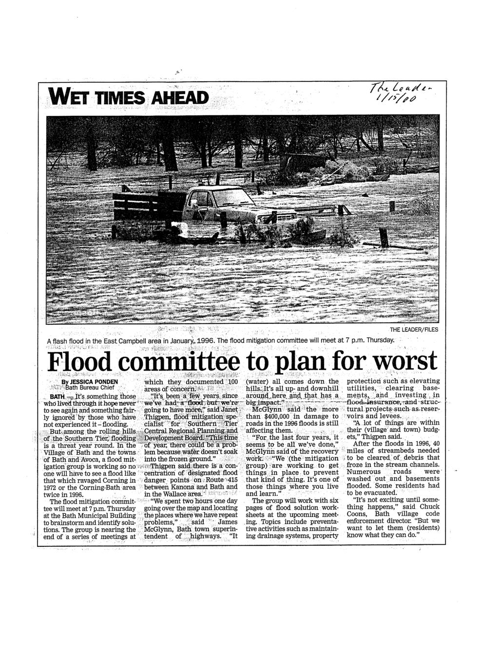
47
48
49 Flood Mitigation Planning Town of Avoca, Town of Bath, & Village of Bath The Town of Avoca, Town of Bath, and Village of Bath have evaluated the communities flooding problems and a variety of potential solutions in order to prepare a program of activities to tackle these problems. WHY? Planning is a critical step toward coordinated implementation of activities that will reduce flood damages. Fulfill planning requirements for state or federal assistance programs (particularly the newly established Flood Mitigation Assistance Program). Qualify for Community Rating System credit toward reduced flood insurance premiums. ASSESS THE FLOOD HAZARDS AND PROBLEMS Municipal officials have identified and documented 107 flooding and drainage problems in the Town of Avoca, Town of Bath, and Village of Bath. This documentation includes problems that have been addressed by the municipalities as well as those that still require resolution. Maps indicating the locations of flood problem areas were prepared. SET RISK REDUCTION GOALS Long-range goals for reducing future flood damages in Avoca and Bath were proposed. These goals emphasize the need for public information, implementation of measures to prevent additional flooding problems, and protection of property that is currently at risk. ASSESS POSSIBLE MITIGATION MEASURES Participants reviewed a comprehensive list of possible measures for resolving flooding problems. They identified those solutions that are most applicable to the flooding problems and community needs in the Town of Avoca, Town of Bath, and Village of Bath. DEVELOP AN ACTION PLAN Municipal officials prepared an Action Plan, which describes 24 activities that can be implemented locally to address flooding problems. This Plan will be reviewed and updated annually to incorporate subsequent steps toward achieving the communities long-term flood damage reduction goals. REVIEW AND ADOPTION OF THE PLAN The Town of Avoca, Town of Bath, and Village of Bath are now soliciting comments and input to the Draft Flood Mitigation Action Plan. Once local input has been incorporated, the Plan will be submitted to the State Emergency Management Office and Federal Emergency Management Agency for approval. It will then be presented to each municipal board for adoption. Adoption of this plan will enable the municipalities to qualify for Flood Mitigation Assistance grant funding.
50 ATTACHMENT B Maps of Flood Hazards and Problems Summary of Flooding Problems
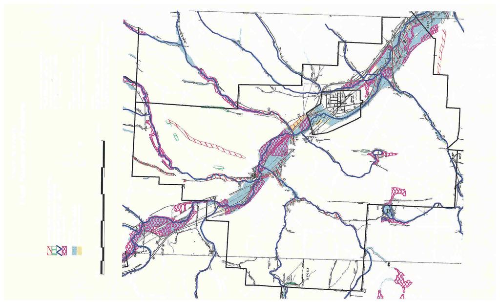
51
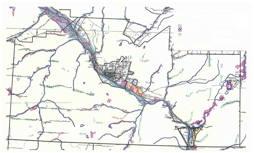

52
53
54
55
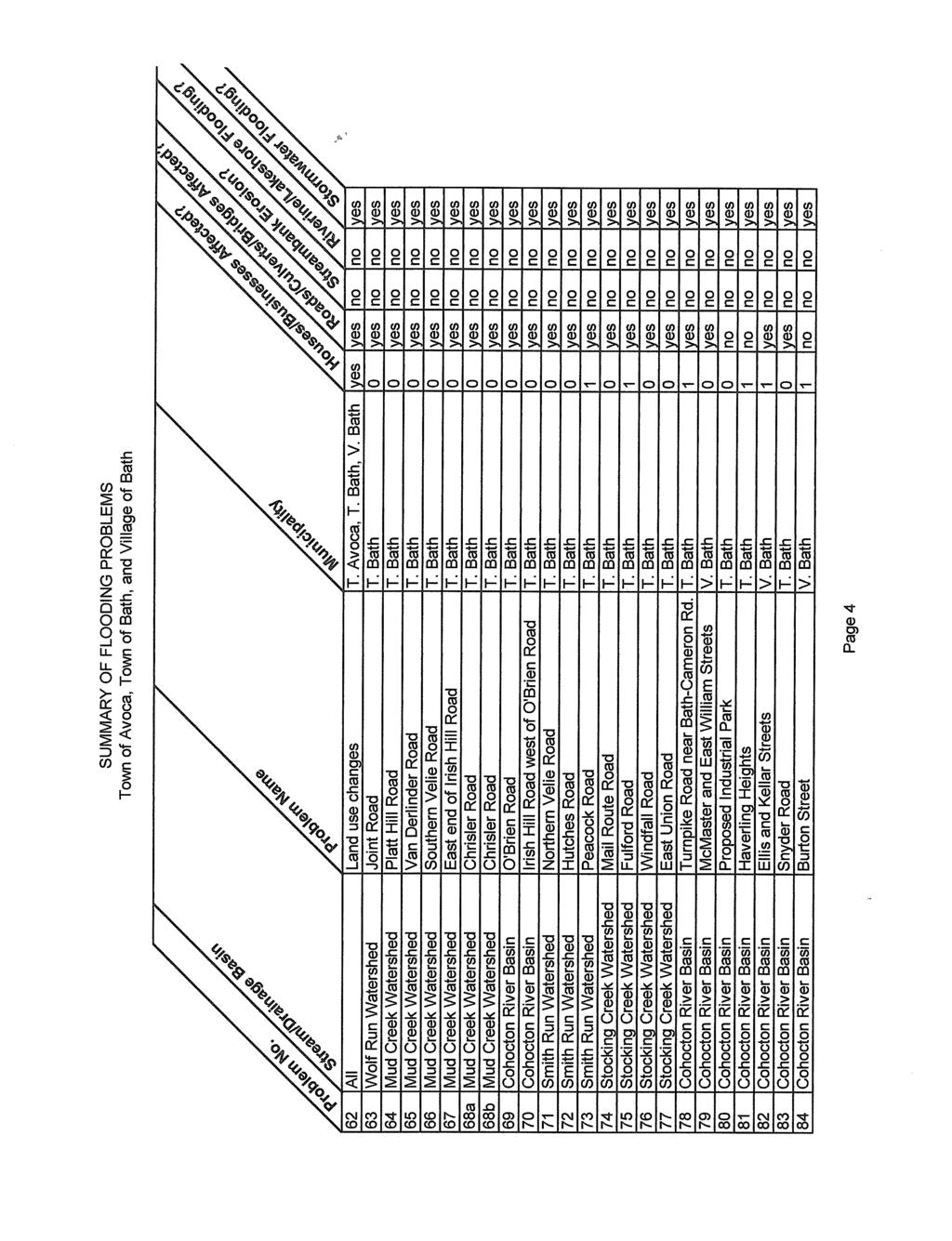
56
57
58
59 ATTACHMENT C State Permitted Dams in Avoca and Bath
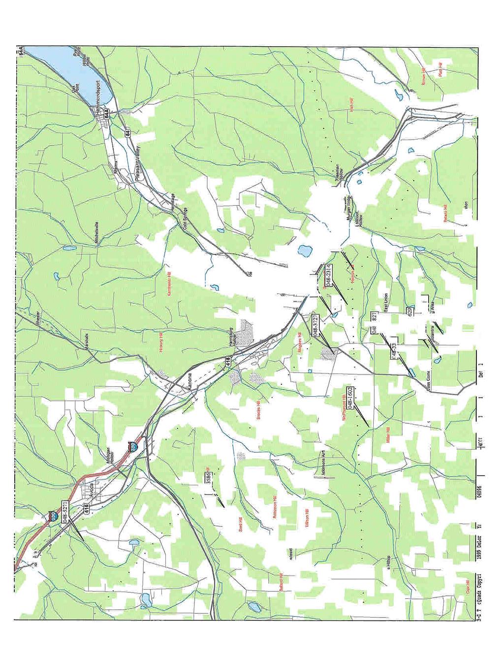
60
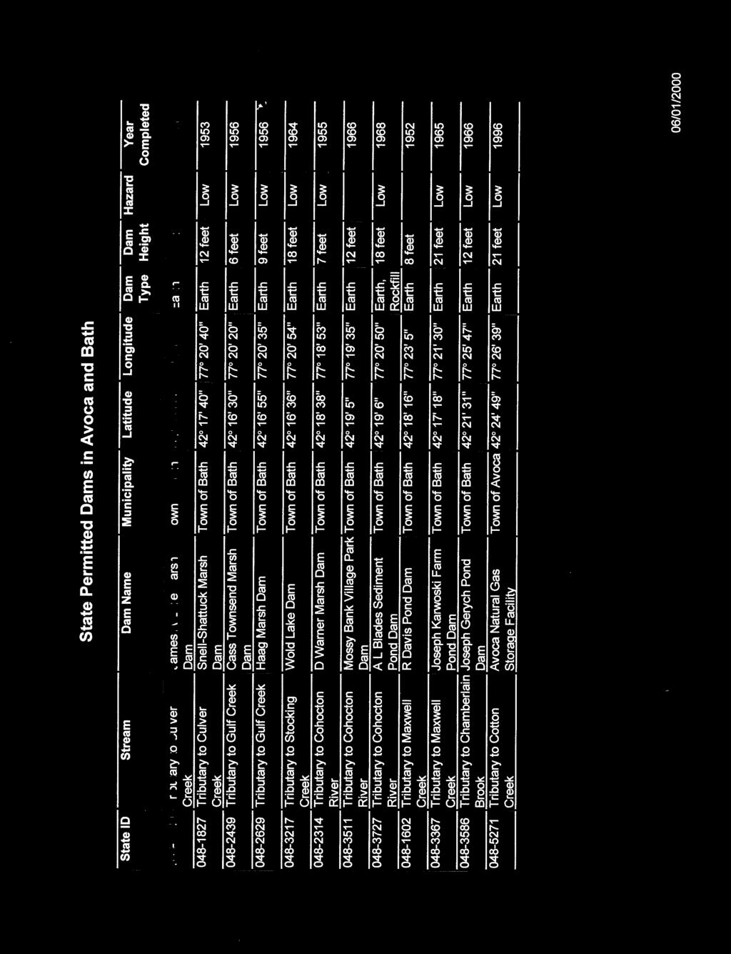
61
SECTION 11: REGULATORY FLOODWAYS
 SECTION 11: REGULATORY FLOODWAYS Contents 11.1. The Floodway... 11-2 11.1.1. The floodway concept... 11-2 11.1.2. Floodway map... 11-2 11.1.3. Floodway permitting... 11-3 11.1.4. Changing the floodway...
New Castle County, DE. Floodplain Regulations
 New Castle County, DE Floodplain Regulations John J. Gysling, PE CFM Department of Land Use New Castle County, DE February 26, 2009 Today s Presentation Floodplain Protection and Uses Terms and Definitions
Natural Hazards Mitigation Plan Kankakee County, Illinois Executive Summary
 1. Introduction Natural Hazards Mitigation Plan Kankakee County, Illinois Executive Summary Kankakee County s first Natural Hazards Mitigation Plan was adopted by the Kankakee County Board on October 11,
COON CREEK WATERSHED DISTRICT PERMIT REVIEW. Spring Lake Park Schools Westwood Middle School st Avenue NE, Spring Lake Park, MN 55432
 PAN 16-112, Westwood Middle School, Page 1 of 6 COON CREEK WATERSHED DISTRICT PERMIT REVIEW MEETING DATE: August 22, 2016 AGENDA NUMBER: 10 FILE NUMBER: 16-112 ITEM: Westwood Middle School RECOMMENDATION:
NEW CASTLE CONSERVATION DISTRICT. through. (Name of Municipality) PLAN REVIEW APPLICATION DRAINAGE, STORMWATER MANAGEMENT, EROSION & SEDIMENT CONTROL
 PLAN REVIEW APPLICATION DRAINAGE, STORMWATER MANAGEMENT, EROSION & SEDIMENT CONTROL") NEW CASTLE CONSERVATION DISTRICT through (Name of Municipality) PLAN REVIEW APPLICATION DRAINAGE, STORMWATER MANAGEMENT, EROSION & SEDIMENT CONTROL Office use only: Received by Municipality: Received by
NEW CASTLE CONSERVATION DISTRICT through (Name of Municipality) PLAN REVIEW APPLICATION DRAINAGE, STORMWATER MANAGEMENT, EROSION & SEDIMENT CONTROL Office use only: Received by Municipality: Received by
King County Flood Control District approves grants for flood prevention projects Regional projects to benefit from district funds
 News Release Contact: Al Sanders 206-477-1016 August 31, 2015 Flood Control District approves grants for flood prevention projects Regional projects to benefit from district funds The Flood Control District
Lyon Creek Cedar Way Stormwater Detention Dam Operation and Maintenance Manual
 Lyon Creek Cedar Way Stormwater Detention Dam Operation and Maintenance Manual Prepared by: Mike Shaw Stormwater Program Manager City of Mountlake Terrace January 2010 Section I General Information This
CHAPTER 3 Environmental Guidelines for WATERCOURSE CROSSINGS GOVERNMENT OF NEWFOUNDLAND AND LABRADOR DEPARTMENT OF ENVIRONMENT AND LABOUR
 GOVERNMENT OF NEWFOUNDLAND AND LABRADOR DEPARTMENT OF ENVIRONMENT AND LABOUR CHAPTER 3 Environmental Guidelines for WATERCOURSE CROSSINGS WATER RESOURCES MANAGEMENT DIVISION Water Investigations Section
Project Alignment Appendix A
 Project Alignment Appendix A Fargo Moorhead Metropolitan Area Flood Risk Management Project EA Document This page is intentionally left blank Project Alignment Appendix A Table of Contents 1 BACKGROUND...
SECTION 3 NATURAL RESOURCES
 SECTION 3 NATURAL RESOURCES The natural environment plays a large role in planning for future development. Environmental conditions, such as topography, wetlands, floodplains, and water bodies, can often
BIG ROCHE A CRI LAKE CHARACTERISTICS
 BIG ROCHE A CRI LAKE CHARACTERISTICS Lake Description Big Roche Cri Lake is located in north central Adams County and has a surface area of 205 acres, a shoreline length of 6.1 mile, a volume of 6,993
CHAPTER 6 ADDITIONAL STANDARDS APPLYING TO SHORELAND AREAS AND PUBLIC WATERS
 CHAPTER 6 ADDITIONAL STANDARDS APPLYING TO SHORELAND AREAS AND PUBLIC WATERS Section 1 Intent. 49 Section 2 Floodplain Requirements 49 Section 3 Water-Oriented Accessory Structures 50 Section 4 Stairways,
Holly Swartz and Jason Shirey
 Chapter 105 General Permits for Stream and Wetland Impacts DEP Ch. 105 CONTACTS FOR BERKS COUNTY: Holly Swartz and Jason Shirey What DEP Regulates Under Chapter 105 Waters of the Commonwealth, which includes
Temporary Watercourse Crossing: Culverts
 Temporary Watercourse Crossing: Culverts DRAINAGE CONTROL TECHNIQUE Low Gradient Velocity Control Short Term Steep Gradient Channel Lining Medium-Long Term Outlet Control Soil Treatment Permanent Symbol
East St. Tammany Storm Surge Protection Project Request
 East St. Tammany Storm Surge Protection Project Request Submitted to Coastal Protection & Restoration Authority of Louisiana (CPRA) August 2015 Contact Information: Thomas Nolan Thompson The East St. Tammany
DRAFT GREATER MOOSES TOOTH TWO (GMT2) DEVELOPMENT PROJECT PERMITTEE RESPONSIBLE WETLANDS MITIGATION PLAN NATIONAL PETROLEUM RESERVE-ALASKA
 DEVELOPMENT PROJECT PERMITTEE RESPONSIBLE WETLANDS MITIGATION PLAN NATIONAL PETROLEUM RESERVE-ALASKA") DRAFT GREATER MOOSES TOOTH TWO (GMT2) DEVELOPMENT PROJECT PERMITTEE RESPONSIBLE WETLANDS MITIGATION PLAN NATIONAL PETROLEUM RESERVE-ALASKA Prepared for: ConocoPhillips Alaska, Inc. Anchorage, AK March
DRAFT GREATER MOOSES TOOTH TWO (GMT2) DEVELOPMENT PROJECT PERMITTEE RESPONSIBLE WETLANDS MITIGATION PLAN NATIONAL PETROLEUM RESERVE-ALASKA Prepared for: ConocoPhillips Alaska, Inc. Anchorage, AK March
MODEL Stormwater Local Design Manual. City of Centerville
 MODEL Stormwater Local Design Manual City of Centerville Adopted December 6, 2005 TABLE OF CONTENTS 1. FORWARD... 1 2. GENERAL LEVEL OF SERVICE STANDARDS... 1 2.1. DETENTION REQUIREMENTS... 1 2.1.1. Discharge
Stormwater Local Design Manual For Houston County, Georgia
 Stormwater Local Design Manual For Houston County, Georgia Adopted November 15, 2005 TABLE OF CONTENTS 1. FORWARD... 1 2. GENERAL LEVEL OF SERVICE STANDARDS... 2 2.1. DETENTION REQUIREMENTS... 2 2.1.1.
APPENDIX A. Project Scoping
 APPENDIX A Project Scoping Notice of Preparation To: From: Agencies and Interested Parties Paul Brunner, Executive Director, Three Rivers Levee Improvement Authority Date: June 13, 2006 Subject: Notice
TWIN PLATTE NATURAL RESOURCES DISTRICT
 TWIN PLATTE NATURAL RESOURCES DISTRICT Twin Platte NRD Multi-Jurisdictional Hazard Mitigation Plan Update Twin Platte NRD Multi-Jurisdictional Hazard Mitigation Plan Update 2016 1 INTRODUCTION This HMP
What is a stormwater utility fee?
 What is a stormwater utility fee? A stormwater utility fee is similar to a water or sewer utility fee. In essence, customers pay a fee to convey stormwater from their properties. The City of Goodlettsville
E. STORMWATER MANAGEMENT
 E. STORMWATER MANAGEMENT 1. Existing Conditions The Project Site is located within the Lower Hudson Watershed. According to the New York State Department of Environmental Conservation (NYSDEC), Lower Hudson
Information for File # PRH
 Information for File # 2016-02602-PRH Applicant Corps Contact Tom Morley Paul Hauser Address 152 Baker Drive, Redwood Falls, MN 56283 E-Mail Paul.R.Hauser@usace.army.mil Phone 651-290-5357 Primary County
Cass County Soil Erosion & Sedimentation Control Program
 Cass County Soil Erosion & Sedimentation Control Program Both residents and visitors of Cass County enjoy the beauty of over 250 lakes and ponds, along with numerous streams, creeks, and wetlands that
3 PROJECT DESCRIPTION
 3.1 PROJECT OVERVIEW 3 PROJECT DESCRIPTION The Rocklin 60 project (proposed project) includes the subdivision of 56.9 acres of land, construction of 179 single-family, detached dwelling units, and installation
SECTION 3 DRAINAGE. 3-1 General. 3-2 Drainage Ordinances and Legal Requirements
 SECTION 3 DRAINAGE 3-1 General All Drainage plans for proposed development shall be prepared by a Professional Engineer registered in Virginia, except as noted below. Further, their seal and signature
Ponds. Pond A water impoundment made by excavating a pit, or constructing a dam or an embankment.
 POND SITE SELECTION AND CONSTRUCTION Uses, Planning, & Design David Krietemeyer Area Engineer USDA-NRCS June 20, 2008 Uses Considerations for Location of Commonly Used Terms Pond A water impoundment made
SW-74 SERENOVA PRESERVE SITES 2, 3, 4, 8 MITIGATION PLAN
 SW-74 SERENOVA PRESERVE SITES 2, 3, 4, 8 MITIGATION PLAN BACKGROUND INFORMATION Project SWIM? Aquatic Control? Exotic Control? Mitigation Bank? Type No No No No Mitigation Restoration and enhancement Type
South St. Vrain / Hall Meadows Restoration Planning August 20, 2015
 South St. Vrain / Hall Meadows Restoration Planning August 20, 2015 Agenda Introductions Purpose & Goals of Meeting Planning Area Master Plan Restoration Planning: Cost Estimates, Grants, Scope, Timeline
STATE OF MINNESOTA MINNESOTA POLLUTION CONTROL AGENCY
 STATE OF MINNESOTA MINNESOTA POLLUTION CONTROL AGENCY In the Matter of the Decision on the Need for an Environmental Impact Statement for the Proposed Remer Wastewater Treatment Facility Expansion FINDINGS
Municipal Stormwater Ordinances Summary Table
 APPENDIX F Municipal Ordinances Summary Table Municipality Abington Bryn Athyn Borough Hatboro Borough Ordinance, SALDO Runoff equals pre post Erosion Sediment Control Water Quality Requirements Any which
Environmental Information Worksheet
 Environmental Information Worksheet Water System Owner (Attach additional sheets if necessary) Needs and Alternatives Provide a brief narrative that describes: Current drinking water system needs. Project
TORCH LAKE TOWNSHIP WATER QUALITY ACTION PLAN
 TORCH LAKE TOWNSHIP WATER QUALITY ACTION PLAN Elk-River-Chain-of-Lakes Gaps Analysis Project The Watershed Center Grand Traverse Bay Tip of the Mitt Watershed Council Michigan Department of Natural Resources
VOLUME 1 TABLE OF CONTENTS
 Santiago Hills Phase II Planned Community and East Orange Planned Community Area 1 Issue Date: 2, May 20055 VOLUME 1 TABLE OF CONTENTS SECTION 1: INTRODUCTION... 1-1 1.1 PROJECT DESCRIPTION... 1-1 1.2
Stormwater Management Studies PDS Engineering Services Division ES Policy # 3-01
 Stormwater Management Studies PDS Engineering Services Division Revised Date: 2/28/08 INTRODUCTION The City of Overland Park requires submission of a stormwater management study as part of the development
C Fish Lake C Rice Lake C Mud Lake C Weaver Lake C Elm Creek*
 IV. PROBLEMS AND CORRECTIVE ACTIONS Outlined below is an assessment of existing and potential water resource-related issues that are known at this time. These issues have been identified based on Commission
Recommended Resources: The following resources may be useful in teaching this lesson:
 Unit E: Basic Principles of Soil Science Lesson 7: Understanding Soil Erosion and Management Practices Student Learning Objectives: Instruction in this lesson should result in students achieving the following
UNIVERSITY OF OREGON NORTH CAMPUS CONDITIONAL USE PERMIT PROJECT Draft Conditional Use Permit Stormwater, Sanitary Sewer, and Water Analysis Report
 UNIVERSITY OF OREGON NORTH CAMPUS CONDITIONAL USE PERMIT PROJECT Draft Conditional Use Permit Stormwater, Sanitary Sewer, and Water Analysis Report Prepared for: Cameron McCarthy Landscape Architects LLP
SECTION 2 CALDWELLL COUNTY CHARACTERISTICS
 SECTION 2 CALDWELLL COUNTY CHARACTERISTICS 2.1 City Limits and ETJ Boundaries The name Caldwell was given to the county in recognition of an Indian Fighter named Matthew Caldwell, who led a group of militia
Streamlines V2, n2 (May 1997) A Newsletter for North Carolina Water Supply Watershed Administrators
 A Newsletter for North Carolina Water Supply Watershed Administrators") Page 1 of 5 STREAMLINES A Newsletter for North Carolina Water Supply Watershed Administrators Volume 2, Number 2 May 1997 Non-Point Source (NPS) Pollution This issue of Streamlines provides basic information
Page 1 of 5 STREAMLINES A Newsletter for North Carolina Water Supply Watershed Administrators Volume 2, Number 2 May 1997 Non-Point Source (NPS) Pollution This issue of Streamlines provides basic information
Unit E: Basic Principles of Soil Science. Lesson 7: Understanding Soil Erosion and Management Practices
 Unit E: Basic Principles of Soil Science Lesson 7: Understanding Soil Erosion and Management Practices 1 Important Terms Accelerated erosion Conservation tillage Cover crops Diversion ditches Geologic
REQUEST FOR QUALIFICATIONS FOR DAYTON VALLEY AREA DRAINAGE MASTER PLAN
 REQUEST FOR QUALIFICATIONS FOR DAYTON VALLEY AREA DRAINAGE MASTER PLAN Statement of Qualifications due Friday, November 3, 2017 at 12:00 PM (Pacific Time) To the Carson Water Subconservancy District Office
Storm Water and Sanitary Sewer
 Public Works Department Summary Report on Planned Capital Improvements Storm Water and Sanitary Sewer Introduction Public Works has assembled this summary report to highlight major capital improvements
GREEN BROOK FLOOD CONTROL PROJECT FLOODPLAIN MANAGEMENT PLAN
 GREEN BROOK FLOOD CONTROL PROJECT FLOODPLAIN MANAGEMENT PLAN Table of Contents Section Page Section 1: INTRODUCTION... 1 1.1 Authority and Purpose... 1 1.2 Format of the Plan... 2 1.3 Project Background...
Mr. Michael Malone CPS Energy 145 Navarro Street San Antonio, Texas Project No
 Environmental Resources Management January 13, 2017 Mr. Michael Malone 145 Navarro Street San Antonio, Texas 78205 Project No. 0352436 CityCentre Four 840 West Sam Houston Parkway North, Suite 600 Houston,
POLICY FOR NATURAL RESOURCE MANAGEMENT AREAS
 POLICY FOR NATURAL RESOURCE MANAGEMENT AREAS I. POLICY STATEMENT Auburn University's (the University's) "Policy for Natural Resource Management Areas" implements the Campus Master Plan Land Use Element
Understanding Soil Erosion and Management Practices
 Lesson C6 8 Understanding Soil Erosion and Management Practices Unit C. Plant and Soil Science Problem Area 6. Basic Principles of Soil Science Lesson 8. Understanding Soil Erosion and Management Practices
Application for resource consent Form B Damming and diversion of water
 Application for resource consent Form B Damming and diversion of water Notes Resource use activities must meet all the conditions of any relevant Permitted Activity Rules in the Waikato Regional Plan or
SOURCE WATER ASSESSMENT SUMMARY BROCHURE
 SOURCE WATER ASSESSMENT SUMMARY BROCHURE CITY OF ROGUE PWS # 4100712 WHAT IS A SOURCE WATER ASSESSMENT? The Source Water Assessment was recently completed by the Department of Environmental Quality (DEQ)
WATERSHED. Maitland Valley. Report Card 201
 Maitland Valley WATERSHED Report Card 201 The Maitland Valley Conservation Authority has prepared this report card as a summary on the state of our forests, wetlands, surface water, and ground water resources.
Preface. MNR # Queen s Printer for Ontario, 2012 ISBN (PRINT) ISBN (PDF)
 ISBN (PDF)") Preface In 2008, the inter-agency Drainage Act & Section 28 Regulations Team (DART) was established by the Ministry of Natural Resources (MNR) and the Ministry of Agriculture, Food and Rural Affairs (OMAFRA)
Preface In 2008, the inter-agency Drainage Act & Section 28 Regulations Team (DART) was established by the Ministry of Natural Resources (MNR) and the Ministry of Agriculture, Food and Rural Affairs (OMAFRA)
Chapter 10 Natural Environment
 Chapter 10 Natural Environment Existing Conditions The Natural Environment Element addresses the protection, conservation, preservation, and restoration of the natural resources the Bayview Ridge Subarea,
CHAPTER 7. San Dieguito River Flooding Adaptation
 CHAPTER 7 San Dieguito River Flooding Adaptation This chapter includes a range of adaptation measures to address vulnerabilities from flooding along the San Dieguito River, including the river valley,
Stream Reaches and Hydrologic Units
 Chapter United States 6 Department of Agriculture Natural Resources Conservation Service Chapter 6 Stream Reaches and Hydrologic Units Rain clouds Cloud formation Precipitation Surface runoff Evaporation
Economics of Implementing Two-stage Channels
 2011 A Partnership of USDA NIFA & Land Grant Colleges and Universities Economics of Implementing Two-stage Channels GREAT LAKES REGION Jon Witter, Jessica D Ambrosio, Joe Magner, Andy Ward and Bruce Wilson
COMMUNITY PROFILE PLATTE VALLEY IRRIGATION DISTRICT. Twin Platte Natural Resources District Multi-Jurisdictional Hazard Mitigation Plan Update
 COMMUNITY PROFILE PLATTE VALLEY IRRIGATION DISTRICT Twin Platte Natural Resources District Multi-Jurisdictional Hazard Mitigation Plan Update Twin Platte NRD Multi-Jurisdictional Hazard Mitigation Plan
TOWN OF KILL DEVIL HILLS, NORTH CAROLINA ANNUAL PROGRESS REPORT ON ADOPTED HAZARD MUTIGATION PLAN COMMUNITY #
 TOWN OF KILL DEVIL HILLS, NORTH CAROLINA ANNUAL PROGRESS REPORT ON ADOPTED HAZARD MUTIGATION PLAN COMMUNITY # 375353 Since the last application for continued participation in the Community Rating System
TES Industrial Development SW ¼ SEC Lacombe County Outline Plan
 TES Industrial Development Lacombe County Outline Plan 112849297 June 2012 am v:\1128\active\112849297\07_reports_studies\rpt_tes_20120508.doc i Table of Contents 1.0 INTRODUCTION... 1 1.1 PURPOSE... 1
FINDINGS: Olsson used a three-step analysis strategy to develop a benefit cost ratio that would indicate the relative feasibility of this project.
 EXECUTIVE SUMMARY FINDINGS: Based on the results of this feasibility study, the Platte Republican Diversion Project would be cost-effective. With minimal improvements to the channel, and the existing bridge
The Clean Water Act Waters of the US Proposed Rule -- What is it and what are the implications for agriculture?
 The Clean Water Act Waters of the US Proposed Rule -- What is it and what are the implications for agriculture? August 1, 2014 1 Acronyms and Terms Agencies CWA WOTUS Rule FEMA USGS Environmental Protection
EFFECT OF UPSTREAM DEVELOPMENT ON THE CLEAR CREEK AREA
 EFFECT OF UPSTREAM DEVELOPMENT ON THE CLEAR CREEK AREA Technical Memorandum Farming in the Floodplain Project Prepared for May 2017 PCC Farmland Trust Photo credit: Google Earth TABLE OF CONTENTS Page
In Your House and in Your Yard, Watch for Water, Be on Guard
 In Your House and in Your Yard, Watch for Water, Be on Guard KEY TERMS Arroyo: A water-carved gully or a normally dry creek found in arid or desert regions. Dam: A barrier built across a river, stream
STORM WATER MANAGEMENT REPORT
 Silvercreek Junction STORM WATER MANAGEMENT REPORT Howitt Creek at the Silvercreek Parkway Site Guelph, Ontario August, 2008 TSH File 22304A-04 August 19, 2008 STORMWATER MANAGEMENT REPORT Howitt Creek
CHAPTER 8 EROSION AND SEDIMENT CONTROL PLAN REQUIREMENTS
 CHAPTER 8 EROSION AND SEDIMENT CONTROL PLAN REQUIREMENTS 8.1 INTRODUCTION To minimize the detrimental effects of erosion and sedimentation, Henrico County requires that those individuals responsible for
Walnut Creek Watershed Management Authority. Project Kick Off March 18, 2015
 Walnut Creek Watershed Management Authority Project Kick Off March 18, 2015 Agenda Schedule & Meeting Purpose Meeting Purpose TMDL Raccoon River TMDL Impaired by Nitrate and E.coli Includes Walnut Creek
Public Notice. Applicant: Lennar Homes Project No.: SWF Date: October 29, Name: Mr. Darvin Messer Phone Number:
 Public Notice Applicant: Lennar Homes Project No.: SWF-2013-00265 Date: October 29, 2013 The purpose of this public notice is to inform you of a proposal for work in which you might be interested. It is
Project Drainage Report
 Design Manual Chapter 2 - Stormwater 2A - General Information 2A-4 Project Drainage Report A. Purpose The purpose of the project drainage report is to identify and propose specific solutions to stormwater
STREAM AND BUFFER AREA PROTECTION/RESTORATION
 STREAM AND BUFFER AREA PROTECTION/RESTORATION AMENDMENT OPTIONS TO STRENGTHEN POLICY IN HEADWATERS AREAS DRAFT SUBSEQUENT TO THE JANUARY 25, 2007 MEETING OF THE PLANNING COMMISSION ENVIRONMENT COMMITTEE
Constructed Wetland Pond T-8
 Constructed Wetland Pond T-8 Description A constructed wetlands pond is a shallow retention pond designed to permit the growth of wetland plants such as rushes, willows, and cattails. Constructed wetlands
Appendix D - Evaluation of Interim Solutions
 Appendix D - Evaluation of Interim Solutions D.1 Introduction The implementation of long-term improvements is projected to take 5 to 8 years. To reduce the number of years of flooding impacts, the partner
NJDEP Regulations that impact or soon will impact agricultural operations. April 1, 2007 Horses 2007
 NJDEP Regulations that impact or soon will impact agricultural operations. April 1, 2007 Horses 2007 Peter L. Kallin, Ph.D., P.W.S. Phone: 732-499-3600 Ext. 237 E-mail: pkallin@aesop.rutgers.edu www.water.rutgers.edu
Erosion and Sediment Control Plan for a Timber Harvesting Operation
 3930-FM-WM0155 Rev. 7/2004 Erosion and Sediment Control Plan for a Timber Harvesting Operation 1. GENERAL INFORMATION A. Location Municipality B. Timber sale area = acres Date County C. Landowner Name
CHAPTER 9 DISCUSSIONS, CONCLUSIONS, AND RECOMMENDATIONS
 CHAPTER 9 DISCUSSIONS, CONCLUSIONS, AND RECOMMENDATIONS This chapter summarizes the results of feasibility level investigations undertaken to identify solutions to the water and related land resource problems
SOUTH FLORIDA WATER MANAGEMENT DISTRICT. Question 13: Wetlands
 SOUTH FLORIDA WATER MANAGEMENT DISTRICT Question 13: Wetlands 1. The wetland responses and topographical data provided in the ADA for the 520- acre project site are conceptual in nature. The referenced
Public Notice. Applicant: City of Dallas Project No.: SWF Date: April 18, Name: Chandler Peter Phone Number:
 Public Notice Applicant: City of Dallas Project No.: SWF- 2014-00151 Date: April 18, 2014 The purpose of this public notice is to inform you of a proposal for work in which you might be interested. It
INSTRUCTIONS FOR USING THE GENERAL PERMIT...i A. GENERAL DESCRIPTION AND FEES
 COMMONWEALTH OF PENNSYLVANIA DEPARTMENT OF ENVIRONMENTAL PROTECTION BUREAU OF WATERWAYS ENGINEERING AND WETLANDS GENERAL PERMIT BWEW-GP-1 FISH HABITAT ENHANCEMENT STRUCTURES TABLE OF CONTENTS PAGE INSTRUCTIONS
STORMWATER POLLUTION PREVENTION PLAN
 STORMWATER POLLUTION PREVENTION PLAN TOWN OF WHITE BEAR, MINNESOTA Date: May 31, 2006 Project No. 13597.000 White Bear Township Storm Water Pollution Prevention Plan BMPS Following are the BMPs included
Village of Mamaroneck Flood Mitigation Status Report
 Village of Mamaroneck Flood Mitigation Status Report Introduction Flooding is a regional problem that must be addressed with regional solutions; There are no quick-fix answers; This is an ongoing process;
Project Goals and Scoping
 Prepared for: Boulder County, Colorado Flood Planning & Preliminary Design Services for South St. Vrain Creek Restoration at Hall Ranch and Scoping May 24, 2016 Meeting with General Public In association
APPENDIX A KETTLE RIVER REACH CHARACTERIZATION TABLES AND REACH MAPS
 APPENDX A KETTLE RVER REACH CHARACTERZATON TABLES AND REACH MAPS Kettle River Reach 1 Reach Description Kettle River from Canada-United States boundary to T39N R32E S2 near the mouth of Tonata Creek Shoreline
Phase II Report on Hydrology, Hydraulics, and Low Water Dams
 Phase II Report on Hydrology, Hydraulics, and Low Water Dams Arkansas River Corridor Tulsa, OK May 2005 Submitted To: U. S. Army Corps of Engineers Tulsa District Prepared by: The GUERNSEY Team 5555 N.
STORMWATER RUNOFF AND WATER QUALITY IMPACT REVIEW
 SUBCHAPTER 8 STORMWATER RUNOFF AND WATER QUALITY IMPACT REVIEW 7:45-8.1 Purpose and scope of review Except for those projects expressly exempted by this chapter or waived by the Commission, the Commission
APPENDIX C INLETS. The application and types of storm drainage inlets are presented in detail in this Appendix.
 Storm Drainage 13-C-1 APPENDIX C INLETS 1.0 Introduction The application and types of storm drainage inlets are presented in detail in this Appendix. 2.0 Inlet Locations Inlets are required at locations
Step 4 DRAFT Last Modified 7/2003. Highway and Right of Way Maintenance Tier 2 Worksheet CEM. Community Environmental Management
 CEM Highway and Right of Way Maintenance Tier 2 Worksheet Community Environmental Management 215 Acknowledgements The New York State Soil and Water Conservation Committee and Department of Environmental
Stormwater Quality Extended Detention Basin Operation and Maintenance (O&M) Manual. for: Located at: Prepared for: Prepared by:
 Manual. for: Located at: Prepared for: Prepared by:") Stormwater Quality Extended Detention Basin Operation and Maintenance (O&M) Manual for: Insert Development Name Located at: Insert Address Prepared for: Insert Property Owner Name, Address, and Phone Number
Stormwater Quality Extended Detention Basin Operation and Maintenance (O&M) Manual for: Insert Development Name Located at: Insert Address Prepared for: Insert Property Owner Name, Address, and Phone Number
State Route 8 Bridge Replacement Project
 OPEN HOUSE PUBLIC INVOLVEMENT MEETING Celebration Church 688 Dan Street, Akron, Ohio Tuesday, July 14, 2015 5:00 PM to 7:00 PM State Route 8 Bridge Replacement Project Existing Bridge Future Bridges: Steel
NOTICE OF PREPARATION
 NOTICE OF PREPARATION Date: June 12, 2014 To: From: Subject: Governor s Office of Planning and Research/State Clearinghouse Unit, Responsible Agencies, Trustee Agencies, and Interested Parties Announcement
EMERGENCY STORAGE PROJECT
 EMERGENCY STORAGE PROJECT San Vicente Pumping Station/Surge Control Facility Carryover Storage and San Vicente Dam Raise EIR/EIS San Vicente Dam Raise Briefing Summary DATE: Oct. 18, 2006 ORGANIZATION:
Attachment 12 Stage 1 Flood Risk Assessment (IE RP-0001)
") IE0311133-22-RP-0001, Issue A 17/10/2013 Attachment 12 Stage 1 Flood Risk Assessment (IE0311133-30-RP-0001) IE0311133-22-RP-0001_A_02.DOC Flood Risk Assessment Celebrating 40 Years in Business Jazz Pharmaceuticals
IE0311133-22-RP-0001, Issue A 17/10/2013 Attachment 12 Stage 1 Flood Risk Assessment (IE0311133-30-RP-0001) IE0311133-22-RP-0001_A_02.DOC Flood Risk Assessment Celebrating 40 Years in Business Jazz Pharmaceuticals
 Good Morning! Bruce Gilman Department of Environmental Conservation and Horticulture Finger Lakes Community College 3325 Marvin Sands Drive Canandaigua, New York 14424 585-785- 1255 gilmanba@flcc.edu Northern
Constructed Wetland Use in Nonpoint Source Control
 Constructed Wetland Use in Nonpoint Source Control Description Constructed wetlands are excavated basins with irregular perimeters and undulating bottom contours into which wetland vegetation is purposely
CHAPTER 26. SAN RAMON VALLEY FIRE PROTECTION DISTRICT ANNEX
 CHAPTER 26. SAN RAMON VALLEY FIRE PROTECTION DISTRICT ANNEX 26.1 HAZARD MITIGATION PLAN POINT OF CONTACT Primary Point of Contact Mike Picard, Battalion Chief 1500 Bollinger Canyon Rd San Ramon, CA 94583
Avista Dam Relicensing Factsheet Commenting on the Draft License Application
 Avista Dam Relicensing Factsheet Commenting on the Draft License Application Please Note: This is intended for informational purposes only and does not constitute legal advice. The life of every river
SECTION 4 SURFACE WATER MANAGEMENT DESIGN AND CONSTRUCTION REQUIREMENTS
 SECTION 4 SURFACE WATER MANAGEMENT DESIGN AND CONSTRUCTION REQUIREMENTS Page 4-1 INTRODUCTION 4-3 4-1.01 Applicability of VMCs 14.24, 14.25, 14.26 4-4 4-1.02 Minimum Requirements - Projects Below Threshold
Hat Creek Planning Unit. Fish, Plant, and Wildlife Habitat. LCP Volume II Supporting Analysis for Recommendations
 Hat Creek Planning Unit Fish, Plant, and Wildlife Habitat Conduct surveys of the planning unit to identify biological resources and enable their protection. Though a partial survey of botanical resources
VILLAGE OF BELLAIRE WATER QUALITY ACTION PLAN
 VILLAGE OF BELLAIRE WATER QUALITY ACTION PLAN Elk-River-Chain-of-Lakes Gaps Analysis Project The Watershed Center Grand Traverse Bay Tip of the Mitt Watershed Council Michigan Department of Natural Resources
THE CROSSROADS IN WINCHESTER 4. DRAINAGE PLAN. 4. Drainage Plan. a. Drainage Plan Description
 THE CROSSROADS IN WINCHESTER 4. DRAINAGE PLAN 4. Drainage Plan a. Drainage Plan Description The Specific Plan area drains naturally into two separate watersheds: approximately 6 percent of the Specific