Opportunities for Risk-Based Asset Management in Flood Resilience
|
|
|
- Scott Harrison
- 6 years ago
- Views:
Transcription

1 Opportunities for Risk-Based Asset Management in Flood Resilience A Retrospective on the October 2015 South Carolina Flooding TRB 11 th National Conference on Transportation Asset Management July 11, 2016
2 Agenda Post-Event Assessment of Resilience (PEAR) in South Carolina October 2015 Vulnerability Assessment Scoring Tool: Using an indicator-based approach to screen vulnerability Aligning desk-based reviews with actual conditions Implications for asset management What s missing in our data sets? Where do we go from here? 2
3 Project Overview 3

4 Post-Event Assessment of Resilience (PEAR) Retrospective analysis of resilience in the wake of disasters Seeks to overcome deficiencies of model-based and indicator-based approaches for understanding vulnerability, resilience, and effectiveness of adaptation ICF used the Richland County, SC, transportation system as an area of analysis to test PEAR Cane Bay subdivision, Summerville, SC (Photo credit: U.S. National Weather Service) 4


; Jake Keller, Parsons")
5 October 2015 Flooding, South Carolina From October 2-5, between 10 and 20 inches of rain fell across Richland County Columbia, SC, had the largest rainfall reported of any urban area in South Carolina Photo Credits: U.S. National Weather Service (left); Jake Keller, Parsons Brinckerhoff (right) 5

6 PEAR in Richland County, SC PEAR sought to Assess the adaptive capacity of the transportation system in Richland County, SC Use a desk-based vulnerability scoring tool to retroactively screen transportation assets for climate vulnerabilities and compare results with on-theground impacts 6

7 Vulnerability Assessment Scoring Tool (VAST) Developed for U.S. DOT and publicly available online Uses an indicator-based approach to determine which transportation assets require a closer look at their particular climate vulnerabilities Indicators representative data elements that can be used as a proxy measurement of the overall exposure, sensitivity, and adaptive capacity of specific assets VAST Process 7

8 Sample Indicators Used in VAST 8
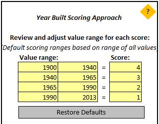
9 Our Analysis Predicted Vulnerability Located in a floodplain Proximity to dams Flood stage Year built Scour rating Channel condition Culvert condition Functional classification Annual average daily traffic Detour length Replacement cost Evacuation route Actual Vulnerability Flood depth Closure duration 9
10 Our Analysis Predicted Vulnerability Located in a floodplain Proximity to dams Flood stage Year built Scour rating Channel condition Culvert condition Functional classification Annual average daily traffic Detour length Replacement cost Evacuation route Actual Vulnerability Flood depth Closure duration Data sources: FEMA National Bridge Inventory SCDOT 10
11 Our Analysis Predicted Vulnerability Located in a floodplain Proximity to dams Flood stage Year built Scour rating Channel Data condition sources: Culvert condition USGS SCDOT Functional classification Annual average daily traffic Detour length Replacement cost Evacuation route Actual Vulnerability Flood depth Closure duration 11
12 Findings 12

; Richland County")
13 FINDINGS How well could we estimate exposure? FEMA Floodplain generally good indicator of actual flood extent for bridges, but not for roads: Source: FEMA Preliminary Flood Extents (left/blue); Richland County GIS (right/orange) 13

14 FINDINGS Dam breaches explain much of the difference 14
15 How well could we estimate sensitivity? Bridges Only two statistically significant indicators of closure duration: Location in a FEMA floodplain (i.e., exposure) 40% of flooded bridges were closed Functional Classification Question: Is this because higher FC bridges are built to a higher design standard and experienced less damage, or because higher FC bridges were prioritized for re-opening? Both? 15

16 How well could we estimate sensitivity? Roads Very different story from bridges Whether a road was actually flooded had very little bearing on whether that road was closed Only 11% of roads that were actually flooded were closed Dams played a greater role: 57% of roads closed for 21 days or longer were within a 2-mile radius of a breached dam Anecdotally: damage to downstream 16


17 Proximity to Dams 17
18 Implications for Asset Management 18
19 Several Data Points Could Improve Flood Damage Predictability Important to get exposure right Flood control structures/dams Updated floodplain mapping Important to better capture likelihood of damage Indicators may be inconsistent or vary by asset type or within region work with engineers and managers to identify indicators Mine institutional knowledge may prove more valuable than indicators evaluated in a vacuum (e.g., floodplain) 19
20 Thank You!
21
 Culvert Condition: Shrinkage cracks, light scaling, and insignificant spalling (7) Major Collector Full Bridge Replacement Needed.")
22 Case Studies SC 769 at Cedar Creek Not located in FEMA 100-year flood zone Built in 1944 Scour rating: Stable Channel Condition: Bank protection in need of minor repairs (7) Culvert Condition: Shrinkage cracks, light scaling, and insignificant spalling (7) Major Collector Full Bridge Replacement Needed. Reopened May 11, 2016 (216 days) 22
 Local Road Not closed or damaged 23")
23 Case Studies SC 48 at Gills Creek Located in FEMA 100-year flood zone Built in 1900 Scour rating: Scour Critical Channel Condition: Bank beginning to slump (6) Local Road Not closed or damaged 23
Maryland Adaptation and Vulnerability Assessment Maryland State Highway Administration
 Maryland Adaptation and Vulnerability Assessment Maryland State Highway Administration October 4, 2016 Maryland: Introduction Atlantic Ocean and Chesapeake Bay 7,719 miles of shoreline Coastal in the East
Adaptation to Extreme Weather Events and Climate Change
 Office of Planning, Environment and Realty Office of Infrastructure Adaptation to Extreme Weather Events and Climate Change SASHTO Meeting Robert Kafalenos, FHWA August 25, 2014 1 Planning for the Future
Climate Change/Extreme Weather Vulnerability and Risk Assessment for Transportation Infrastructure in Dallas and Tarrant Counties
 Climate Change/Extreme Weather Vulnerability and Risk Assessment for Transportation Infrastructure in Dallas and Tarrant Counties Yekang Ko (School of Urban and Public Affairs) With Arne Winguth & Jun
Mike Jastremski, CFM Watershed Conservation Director
 Planning for Flood Resilient and Fish Friendly Road-Stream Crossings in CT s Northwest Hills Mike Jastremski, CFM Watershed Conservation Director Presentation Outline Project area Climate threats Field
Extreme Weather Events and State DOTs
 Extreme Weather Events and State DOTs Date: August 25, 2014 Committee: Presenter: SASHTO Michael Meyer, Parsons Brinckerhoff AASHTO EXTREME WEATHER EVENTS SYMPOSIUM Best Practices for Extreme Weather Management
Hazard Mitigation as an Economic Development Strategy
 Hazard Mitigation as an Economic Development Strategy Linking Water Infrastructure to Community and Economic Development in Smaller Places October 29, 2014 About Us Sustainable Communities Capacity Building
Flash Flood Vulnerability and Climate Adaptation Pilot Project
 Flash Flood Vulnerability and Climate Adaptation Pilot Project Philip Schaffner Office of Transportation System Management Minnesota Department of Transportation MnDOT s Pilot Project Objectives Better
Post Earthquake Bridge Safety Assessment Program
 Post Earthquake Bridge Safety Assessment Program WSDOT/ Structures Team-April 2017 Paul Brallier, SE-, HNTB Corporation Jeri Bernstein, SE-WSDOT 1 Introduction Purpose: Provide agency personnel an introduction
Natural Hazards Mitigation Plan Kankakee County, Illinois Executive Summary
 1. Introduction Natural Hazards Mitigation Plan Kankakee County, Illinois Executive Summary Kankakee County s first Natural Hazards Mitigation Plan was adopted by the Kankakee County Board on October 11,
Culvert Prioritization Model: Aiding Communities in the Selection of Priority Restoration Projects
 Culvert Prioritization Model: Aiding Communities in the Selection of Priority Restoration Projects SNHPC Meeting January 24, 2017 1 Undersized Culverts! Culvert Sizes (~7,500 VT culverts) 6,000 5,000 69%
FloodCast: A Framework for Enhanced Flood Event Decision Making for Transportation Resilience
 NCHRP 20-59(53) FloodCast: A Framework for Enhanced Flood Event Decision Making for Transportation Resilience April 2017 Presenters: Mat Mampara, Caroline Whitehead & Alaurah Moss (Dewberry) Project Overview
Gwinnett County Capital Improvement Planning Utilizing Floodplain Models
 Gwinnett County Capital Improvement Planning Utilizing Floodplain Models Jonathan Semerjian, PE Dept. of Water Resources Stormwater Management Clay Daniel, CFM Dewberry Seyoum Asamenaw, PE Dewberry Gwinnett
Kentucky Dam Safety Hazard Mitigation Driving Local Mitigation Actions through Risk Map
 Kentucky Dam Safety Hazard Mitigation Driving Local Mitigation Actions through Risk Map Michelle Meehan, PE Carey Johnson ASFPM 2013 Conference June 12, 2013 What We ll Talk About Today Overview of KDOW
PLANES, TRAINS & SEMIS South Carolina s Statewide Freight Plan
 PLANES, TRAINS & SEMIS South Carolina s Statewide Freight Plan Multi-Agency Partners Freight Plan Stakeholder Input MTP Kick-Off Meeting with Freight Break-Out Freight Stakeholder Interviews Online Surveys
Alder Drive / Blair Road Bridge Replacement Projects
 Alder Drive / Blair Road Bridge Replacement Projects Presented By: County of El Dorado Community Development Agency Transportation Division Matthew Smeltzer, P.E. Deputy Director of Engineering Paul Hom,
Informational Meeting- July 21, Boxelder B-2/B-3 Watershed Planning Study
 Informational Meeting- July 21, 2015 Boxelder B-2/B-3 Watershed Planning Study Agenda Introductions Background & History Purpose & Need NRCS Watershed Planning Program Work Completed to Date Longer term
(1) Bridge, Road and Railway (Adaptation Project) (2) Bridge, Road and Railway (BAU Development with Adaptation Options)
 Bridge, Road and Railway (Adaptation Project) (2) Bridge, Road and Railway (BAU Development with Adaptation Options)") Sub-sector Guideline: (1) Bridge, Road and Railway (Adaptation Project) (2) Bridge, Road and Railway (BAU Development with Adaptation Options) Basic Concept A. General Concept Climate change will increase
Sub-sector Guideline: (1) Bridge, Road and Railway (Adaptation Project) (2) Bridge, Road and Railway (BAU Development with Adaptation Options) Basic Concept A. General Concept Climate change will increase
America s Climate Choices Adaptation A Challenge to the Transportation Industry
 America s Climate Choices Adaptation A Challenge to the Transportation Industry November 3, 2010 TRB Webinar H. G. Schwartz, Jr. 1 Major Factors Affecting Climate 2 MITIGATION Measures to reduce Greenhouse
New York State DOT Adaptation to Climate Change and Extreme Weather. Elisabeth Lennon New York State Department of Transportation
 New York State DOT Adaptation to Climate Change and Extreme Weather Elisabeth Lennon New York State Department of Transportation Union College, January 2014 New York State Transportation is A vast and
What to Expect When You re Expecting A LOMR. Mark Seidelmann, PE, GISP ASFPM 2015, Atlanta Georgia
 What to Expect When You re Expecting A LOMR Mark Seidelmann, PE, GISP ASFPM 2015, Atlanta Georgia Thursday, June 4 th, 2015 Agenda 1 Why File a Letter Of Map Revision (LOMR)? 2 Basic Requirements and Common
STRATEGIC CASE RESILIENCE INSIGHTS
 STRATEGIC CASE RESILIENCE INSIGHTS PURPOSE This note is for Agency staff and consultants who are developing strategic cases where resilience is identified as a problem. It gives examples and insights using
ADOT Experiences Analyzing and Using Climate Projections: Handling Scientifically-Informed Climate Data Downscaling
 ADOT Experiences Analyzing and Using Climate Projections: Handling Scientifically-Informed Climate Data Downscaling Steven Olmsted Arizona Department of Transportation Intermodal Transportation Division
Sarah White, MEMA. https://resilientma.com/
 Sarah White, MEMA https://resilientma.com/ Background and Framework Code of Federal Regulations Title 44, Chapter 1, Part 201 ( 201.4: State Hazard Mitigation Plans) Disaster Mitigation Act of 2000 (DMA2000)
Sea Level Rise in New York:
 Sea Level Rise in New York: Vulnerabilities and Methods of Analysis Westchester Municipal Planning Federation 2017 Land Use Training Institute April 5, 2017 Anjali Sauthoff What is Sea Level Rise? Image
Office of Strategic Planning and Projects Connecticut Department of Transportation CLIMATE CHANGE & EXTREME WEATHER PILOT PROJECT
 Office of Strategic Planning and Projects Connecticut Department of Transportation CLIMATE CHANGE & EXTREME WEATHER PILOT PROJECT LITCHFIELD HILLS Lake Waramaug, Warren/Kent/Washington LITCHFIELD HILLS
Transportation Vulnerability and Risk Assessment Pilot. American Planning Association Monday, April 16, 2012
 Transportation Vulnerability and Risk Assessment Pilot American Planning Association Monday, April 16, 2012 Goal The goal of Adapting to Rising Tides is to increase preparedness and resilience of Bay Area
Community Disaster Resilience
 Community Disaster Resilience Overview Disaster Management Cycle Community Disaster Resilience Hands on Approach for Increasing Community Disaster Resilience Addressing Weaknesses Planning for the Future
Local Bridge Removal Policies and Programs
 TRS 1702 March 2017 Local Bridge Removal Policies and Programs Prepared by CTC & Associates LLC Many local agencies lack funding to construct and maintain all bridges in their roadway network. One way
Climate change adaptation and rail. Dr Kate Avery Sustainability Specialist (Climate Change Adaptation) 23 rd January 2013
 23 rd January 2013") Climate change adaptation and rail Dr Kate Avery Sustainability Specialist (Climate Change Adaptation) 23 rd January 2013 1 Contents The challenge Our approach Opportunities and hurdles The Challenge Asset
Climate change adaptation and rail Dr Kate Avery Sustainability Specialist (Climate Change Adaptation) 23 rd January 2013 1 Contents The challenge Our approach Opportunities and hurdles The Challenge Asset
Guidance for NEPA and SEPA Project-Level Climate Change Evaluations
 Guidance for NEPA and SEPA Project-Level Climate Change Evaluations Environmental Services Office November 2014 Update Introduction to the 2014 Version WSDOT s Environmental Services Office developed the
Geotechnical asset management for improved highway resilience in Alaska
 Geotechnical asset management for improved highway resilience in Alaska, Consultant Mark Vessely, Shannon & Wilson Darren Beckstrand, Landslide Technology, Inc. David Stanley, D A Stanley Consulting Barry
Lyon Creek Cedar Way Stormwater Detention Dam Operation and Maintenance Manual
 Lyon Creek Cedar Way Stormwater Detention Dam Operation and Maintenance Manual Prepared by: Mike Shaw Stormwater Program Manager City of Mountlake Terrace January 2010 Section I General Information This
FHWA Floodplain, Hydrology and Hydraulics Activities
 FHWA Floodplain, Hydrology and Hydraulics Activities July 17, 2017 AASHTO SCOD/E Meeting, Des Moines, IA 1 Hydrology 2 Highways & Floodplains 614,387 Bridges 509,358 over water Source: 2016 NBI 3 U.S.
Impact of Sea Level Rise on Roadway Design. Paul Carroll, PE
 Impact of Sea Level Rise on Roadway Design Paul Carroll, PE September 14, 2016 State of Maryland Action Executive Order by Gov. O Malley established the Maryland Commission on Climate Change (MCCC) - 2007
Environmental Review Standards for OHTF Funded Projects
 Environmental Review Standards for OHTF Funded Projects Updated May 1, 2017 ENVIRONMENTAL REVIEW STANDARDS FOR OHTF FUNDED PROJECTS Contents Environmental Review Standards... 1 OHTF Funded Projects...
ODOT Asset Management Plan 0
 ODOT Asset Management Plan 0 Table of Contents Executive Summary... 1 ODOT s Experience with Asset Management... 1 A New Way of Doing Business... 2 ODOT s Investment Plans... 3 Moving Forward... 5 1.0
Flooded Bus Barns and Buckled Rails: Public Transportation and Climate Change Adaptation
 Flooded Bus Barns and Buckled Rails: Public Transportation and Climate Change Adaptation Tina Hodges Federal Transit Administration September 22, 2011 Tina.Hodges@dot.gov 1 Key Themes Proactive instead
Project Delivery. Rodger Rochelle, PE Technical Services Administrator. Mike Holder, PE Chief Engineer
 Project Delivery Rodger Rochelle, PE Technical Services Administrator Mike Holder, PE Chief Engineer NC : Project Delivery - Preconstruction Overview of Project Delivery Process Review of Other States
Lessons [being] learnt 2016 Flood in Cedar Rapids. Sandy Pumphrey Project Engineer II Flood Mitigation
![Lessons [being] learnt 2016 Flood in Cedar Rapids. Sandy Pumphrey Project Engineer II Flood Mitigation](/thumbs/77/74998790.jpg "Lessons [being] learnt 2016 Flood in Cedar Rapids. Sandy Pumphrey Project Engineer II Flood Mitigation") Lessons [being] learnt 2016 Flood in Cedar Rapids Sandy Pumphrey Project Engineer II Flood Mitigation 319 286 5363 s.pumphrey@cedar-rapids.org Agenda 2008 Flood Event 2016 Flood Event [Long Term] Flood
Lessons [being] learnt 2016 Flood in Cedar Rapids Sandy Pumphrey Project Engineer II Flood Mitigation 319 286 5363 s.pumphrey@cedar-rapids.org Agenda 2008 Flood Event 2016 Flood Event [Long Term] Flood
Dams: Conditions & Capacity
 The average age of the 84,000 dams in the country is 52 years old. The nation s dams are aging and the number of high-hazard dams is on the rise. Many of these dams were built as low-hazard dams protecting
Implementing Asset Management: WSDOT s Experience
 Implementing Asset Management: WSDOT s Experience 6 th National Conference on Transportation Asset Management Aaron Butters, P.E. Systems Analysis and Program Development Manager November 2, 2005 1 Highway
PRINCESS ANNE DISTRICT STORMWATER PROJECTS
 PRINCESS ANNE DISTRICT STORMWATER PROJECTS Topics o o o o o Sea Level Rise and the Southern Watersheds Ashville Park Sherwood Lakes Kingston Estates Drainage Operations & Maintenance in the Southern Watersheds
NYSDOT Roadway Inventory. Both On and Off the State System
 NYSDOT Roadway Inventory Both On and Off the State System 1 2 NYSDOT Highway Data Services Bureau Highway Data Traffic Monitoring Pavement Data Inventory of public roads, incl. LHI Systems designations
Association of State Floodplain Managers May 2, 2017 Rob Davis, P.E., ENVSP Flood Control System Program Manager
 Association of State Floodplain Managers May 2, 2017 Rob Davis, P.E., ENVSP Flood Control System Program Manager 2008 vs. 2016 Cedar Rapids Population 130,000 Second largest city in Iowa Industrial roots:
South St. Vrain / Hall Meadows Restoration Planning August 20, 2015
 South St. Vrain / Hall Meadows Restoration Planning August 20, 2015 Agenda Introductions Purpose & Goals of Meeting Planning Area Master Plan Restoration Planning: Cost Estimates, Grants, Scope, Timeline
In Service Replacement of Box Girder Bottom Slab
 In Service Replacement of Box Girder Bottom Slab WSDOT Bridge No. 5/537S - Span 11 Craig R. Boone, P.E., S.E. Lynn Peterson Secretary of Transportation 2015 Western Bridge Engineers Seminar Reno, Nevada
Mobility and System Reliability Goal
 Mobility and System Reliability Goal Provide surface transportation infrastructure and services that will advance the efficient and reliable movement of people and goods throughout the state. Background:
World Bank Study: Making Transport Climate Resilient
 World Bank Study: Making Transport Climate Resilient Adapting the road sector to climate change Presented by: Fang Xu, Economist, Africa Region Office, fxu@worldbank.org Karsten Sten Pedersen, Project
APPENDIX A. NEPA Assessment Checklist
 APPENDI A NEPA Assessment Checklist NEPA CHECKLIST DATE: January 12, 2009 PREPARER: Frederick Wells, RLA PIN and Project Title: Surplus Property Request Wilder Balter Partners Marketplace Town of Newburgh,
Building Resilient Communities - Low Impact Development and Green Infrastructure Strategies
 Building Resilient Communities - Low Impact Development and Green Infrastructure Strategies October 24, 2013 Bridgewater State University E. Heidi Ricci Senior Policy Analyst Mass Audubon Shaping the Future
FEMA s National Risk Index
 FEMA s National Risk Index Agenda National Risk Index (NRI) Background NRI Working Groups Calculating and NRI Hazard Data Resilience Score Social Vulnerability and Resilience Data Built Environment Data
Modeling Climate Change Impacts on Flooding in Alaska
 Modeling Climate Change Impacts on Flooding in Alaska Thursday, June 5, 2014 Presented by: Shane Parson, PhD, PE, CFM Kimberley A. Pirri, PE, CFM R. Scott Simmons, CFM, CPM Agenda Project Background Seward,
About Me: Started at Pennington County Highway Department as a Seasonal Flagger while going to college. Graduated from college in 1999 at B.H.S.U.
 1 2 About Me: Started at Pennington County Highway Department as a Seasonal Flagger while going to college Graduated from college in 1999 at B.H.S.U. Hired as a Maintenance Worker and Equipment Operator
Sewer System Flood Reduction Measures in the Rockcliffe Area
 PW28.6 REPORT FOR ACTION Sewer System Flood Reduction Measures in the Rockcliffe Area Date: March 26, 2018 To: Public Works and Infrastructure Committee From: General Manager, Toronto Water Wards: Ward
COSIDERATION OF MULTIPLE HAZARDS IN HIGHWAY BRIDGE DESIGN - A Current FHWA Sponsored Project
 COSIDERATION OF MULTIPLE HAZARDS IN HIGHWAY BRIDGE DESIGN - A Current FHWA Sponsored Project George C. Lee (1), Mai Tong (2) and W. Phillip Yen (3) Abstract Following the philosophy approach of the AASHTO
CITY OF PORTSMOUTH, NEW HAMPSHIRE
 TIDES TO STORMS PREPARING FOR NEW HAMPSHIRE S FUTURE COAST Assessing Risk and Vulnerability of Coastal Communities to Sea Level Rise and Storm Surge Seabrook - Hampton Falls Hampton - North Hampton Rye
Safety, And Quality Of Life Needs
 The Ivey Wellpad Demands Adams County Mitigation Measures Required To Protect Critical Urban Area Health, Safety, And Quality Of Life Needs Overview Health Safety Quality of Live Citizens Support For Mitigation
Iowa Climate Change Adaptation and Resilience: Applying Climate Data to Plans & Ordinances
 Iowa Climate Change Adaptation and Resilience: Applying Climate Data to Plans & Ordinances Christopher J. Anderson, PhD Assistant Director, Climate Science Program Iowa State University Integrating Hazard
Mitigation Plan Mission, Goals and Action Items
 Section 4: Mitigation Plan Mission, Goals and Action Items Introduction... 2 Mission... 2 Mitigation Plan Goals... 2 Natural Hazard Mitigation Plan Action Items... 3 Coordinating Organization... 4 Partner
ASHVILLE PARK STORMWATER UPDATE
 ASHVILLE PARK STORMWATER UPDATE JULY 18, 2017 1 ASHVILLE PARK CHRONOLOGY 2005: Ashville Park conditionally rezoned. Consisted of Five Villages 2006-2007: Village A Wilshire Village was approved and construction
 ASHVILLE PARK STORMWATER UPDATE JULY 18, 2017 1 ASHVILLE PARK CHRONOLOGY 2005: Ashville Park conditionally rezoned. Consisted of Five Villages 2006-2007: Village A Wilshire Village was approved and construction
Selecting Projects for Accelerated Bridge Construction
 Selecting Projects for Accelerated Bridge Construction In January of 2017, the Engineering Services and Operations Division Directors issued a memo instructing Districts to consider accelerated bridge
Mitigation Measures for Natural Hazards
 Mitigation Measures for Natural Hazards Mitigation measures are actions that eliminate or reduce risks from future disaster events, including: Physical construction projects such as replacing a highly
MnDOT Flash Flood Vulnerability and Adaptation Assessment Pilot Project DISTRICT 1 SILVER CREEK CASE STUDY
 MnDOT Flash Flood Vulnerability and Adaptation Assessment Pilot Project DISTRICT 1 SILVER CREEK CASE STUDY NOVEMBER 2014 This document is part of a series of short reports based on the full Flash Flood
Maintenance and Operations Resilience: Improving System Management and Performance During Adverse and Extreme Weather
 Maintenance and Operations Resilience: Improving System Management and Performance During Adverse and Extreme Weather Steven Olmsted Intermodal Transportation Division Arizona Department of Transportation
5th Street Bridge Replacement Project Yuba City, California Location Hydraulic Study Report Bridge No. 18C0012
 EA 03-0L2324 Yuba City, California Location Hydraulic Study Report Submitted to: Prepared by: November 2012 Table of Contents Executive Summary... iii Acronyms... v 1 General Description... 1 1.1 Project
Building Economic Resilience in Your Community: Linking Economic Development and Hazard Mitigation Planning
 Building Economic Resilience in Your Community: Linking Economic Development and Hazard Mitigation Planning Webinar Presentation March 17, 2015 March 17, 2015 2:00 3:15 pm ET Today s Presentation Who we
Project Alignment Appendix A
 Project Alignment Appendix A Fargo Moorhead Metropolitan Area Flood Risk Management Project EA Document This page is intentionally left blank Project Alignment Appendix A Table of Contents 1 BACKGROUND...
Stormwater Control and Treatment
 Stormwater Control and Treatment EXISTING CONDITIONS The topography of Pinellas County is mostly flat to gently sloping, characterized by sandy soils and high groundwater levels. Elevations range from
Lisa B. Beever, PhD, AICP Estero Bay Agency on Bay Management Cela Tega December 12, 2016
 Lisa B. Beever, PhD, AICP Estero Bay Agency on Bay Management Cela Tega December 12, 2016 National Estuary Programs Each of the 28 NEP logos represents broad local partnerships which include citizens,
RESILIENT TRANSPORT. $9.5 billion+ 60% 70% 42% 4,793 km. Over 1/3. $2.1 trillion. Making transportation networks safe, secure, and reliable WHAT WE DO
 RESILIENT TRANSPORT Making transportation networks safe, secure, and reliable Whether they are acting as a connection to crucial services or as life-saving conduits during emergency situations, transport
Cokato Lake (86-263) Wright County. Hydrologic Investigation
 Wright County. Hydrologic Investigation") Cokato Lake (86-263) Wright County Hydrologic Investigation April 14, 2005 Cokato Lake (86-263) Wright County Hydrologic Investigation April 14, 2005 Problem Statement In recent years, heavy rainfall has
Cokato Lake (86-263) Wright County Hydrologic Investigation April 14, 2005 Cokato Lake (86-263) Wright County Hydrologic Investigation April 14, 2005 Problem Statement In recent years, heavy rainfall has
Outline. >Gas Situational Awareness System (GSAS) Background Problem Statement Objectives Functionality System Value
 Background Problem Statement Objectives Functionality System Value") GSAS Overview Outline >Gas Situational Awareness System (GSAS) Background Problem Statement Objectives Functionality System Value 2 GSAS Background and Need > Recognized Features of Natural Gas An increasingly
GSAS Overview Outline >Gas Situational Awareness System (GSAS) Background Problem Statement Objectives Functionality System Value 2 GSAS Background and Need > Recognized Features of Natural Gas An increasingly
HEC-RAS 2D Modeling in Support of Ascension Parish Levee Certification
 HEC-RAS 2D Modeling in Support of Ascension Parish Levee Certification OFMA 2017 Annual Conference September 19, 2017 Presented by: Jeff Doudrick, PE, ENV SP Project Manager HNTB Corporation Agenda Project
Mr. Paul Dunlap, California Department of Water Resources
 Memorandum To: From: Mr. Paul Dunlap, California Department of Water Resources Oroville Dam Spillway Incident Independent Forensic Team Date: September 5, 2017 Re: Interim Status Memorandum Introduction
Local Flood Hazard Mitigation Program. A framework for hazard mitigation in the NYC West of Hudson Water Supply Watersheds
 Local Flood Hazard Mitigation Program A framework for hazard mitigation in the NYC West of Hudson Water Supply Watersheds Flood Hazard Mitigation Defined 2 2 Presentation Overview Why and how is the NYC
Hydrologic Calibration:
 Hydrologic Calibration: UPDATE OF EFFECTIVE HYDROLOGY FOR MARYS CREEK October 2010 Agenda Background Hydrologic model Calibrated rainfall Hydrologic calibration 100 year discharges, Existing Conditions
LMC Overlays For Bridge Deck Preservation 2011 Southeast Bridge Preservation Partnership Meeting, Raleigh NC April 13-15, 2011
 LMC Overlays For Bridge Deck Preservation 2011 Southeast Bridge Preservation Partnership Meeting, Raleigh NC April 13-15, 2011 Michael M. Sprinkel, P.E. Associate Director Virginia Center for Transportation
AASHTO Manual for Bridge Evaluation: Section 3, Bridge Management Systems A Practical Tour
 0 0 0 AASHTO Manual for Bridge Evaluation: Section, Bridge Management Systems A Practical Tour Dave Juntunen P.E. Michigan Department of Transportation Bridge Development Engineer Vice-Chair AASHTO SCOBS
Brisbane River Catchment Flood Study overview
 Brisbane River Catchment Flood Study overview Brisbane River Catchment Flood Study overview Floods can and do occur in the Brisbane River catchment. The Queensland Government, local councils and the community
ArcGIS for Emergency Management. Jess Neuner Nikki Golding
 ArcGIS for Emergency Management Jess Neuner Nikki Golding Agenda Introduction Solution Offering What s Next Your Feedback ArcGIS as a Platform Simple, Open, and Configurable Knowledge Workers Executive
Kentucky Dam Safety and Floodplain Compliance
 Kentucky Dam Safety and Floodplain Compliance Celebrating 10 years KAMM Conference September 10, 2014 Brian Shane Cook, PE, LSIT Kentucky Division of Water (502) 564-3410 ext 4822 Shane.Cook@ky.gov WHY
STRUCTURES SPECIFICATIONS FOR BRIDGE CONSTRUCTION ISSUES. John Westphal, P.E. State Construction Office January 2017
 STRUCTURES SPECIFICATIONS FOR BRIDGE CONSTRUCTION ISSUES John Westphal, P.E. State Construction Office January 2017 Introduction Discuss Defective Materials, as defined within the Specifications Recent
Gwinnett County Stormwater System Assessment Program
 Gwinnett County Stormwater System Assessment Program Jonathan Semerjian, PE Dept. of Water Resources Stormwater Management Sam Fleming, PE Dewberry Presentation Overview Project Background Drivers Enhanced
Walnut Creek Watershed Management Authority. Project Kick Off March 18, 2015
 Walnut Creek Watershed Management Authority Project Kick Off March 18, 2015 Agenda Schedule & Meeting Purpose Meeting Purpose TMDL Raccoon River TMDL Impaired by Nitrate and E.coli Includes Walnut Creek
Lower San Joaquin River Feasibility Study PLAN FORMULATION ADDENDUM
 PLAN FORMULATION ADDENDUM Non-Structural Measure Descriptions Elevate Critical Infrastructure This measure would raise at-risk critical structures above the design inundation level. Elevation would be
Urban Flooding: How can planners help?
 Urban Flooding: How can planners help? Kate Evasic & Nora Beck Chicago Metropolitan Agency for Planning IAFSM 2018 Conference March 14, 2018 Agenda CMAP background Impacts of urban flooding Urban flooding
LANE COUNTY ROAD & BRIDGE MAINTENANCE
 LANE COUNTY ROAD & BRIDGE MAINTENANCE Although most county road pavements and bridges have good condition ratings, current funding and preservation activities fall short of what is needed to protect these
MSD Integrated Watershed Management Planning Approach to Achieve Sustainable Communities
 MSD Integrated Watershed Management Planning Approach to Achieve Sustainable Communities MaryLynn Lodor MSD of Greater Cincinnati Sharon Jean-Baptiste CH2M HILL April 4, 2013 Overview MSD s Environmental
TWIN PLATTE NATURAL RESOURCES DISTRICT
 TWIN PLATTE NATURAL RESOURCES DISTRICT Twin Platte NRD Multi-Jurisdictional Hazard Mitigation Plan Update Twin Platte NRD Multi-Jurisdictional Hazard Mitigation Plan Update 2016 1 INTRODUCTION This HMP
Designing Coastal Community
 Designing Coastal Community Infrastructure for Climate Change Winthrop, Massachusetts May 23 rd, 2017 Public Meeting #2 Study Goal To identify and prioritize critical public infrastructure vulnerable to
Modeling a Complex Hydraulic Environment Using a 1-D Approach Supplemented with Simple 2-D Principles Manas Borah Ed Dickson June 5, 2014
 ASFPM 2014 Annual Conference Modeling a Complex Hydraulic Environment Using a 1-D Approach Supplemented with Simple 2-D Principles Manas Borah Ed Dickson June 5, 2014 Agenda Overview and Background Hydrology
For personal use only
 ABN 28 009 174 761 www.regisresources.com Level 1 1 Alvan Street Subiaco WA 6008 Australia P 08 9442 2200 F 08 9442 2290 20 February 2013 Manager Announcements Company Announcements Office Australian Securities
U.S. Army Corps of Engineers Los Angeles District. US Army Corps of Engineers BUILDING STRONG
 U.S. Army Corps of Engineers Los Angeles District US Army Corps of Engineers BUILDING STRONG 1. Opening Comments; 2. Los Angeles County Drainage Area Project As-Built Condition, Current Condition, and
CLIMATE CHANGE RESILIENCY AND STORM WATER MANAGEMENT: A FEDERAL SITE'S PERSPECTIVE
 drhgfdjhngngfmhgmghmghjmghfmf IAFSM 2016 ANNUAL CONFERENCE TINLEY PARK, ILLINOIS CLIMATE CHANGE RESILIENCY AND STORM WATER MANAGEMENT: A FEDERAL SITE'S PERSPECTIVE PETER LYNCH Environmental Engineer Argonne
Outcomes. Kelly Karll-SEMCOG Margaret Barondess - MDOT
 Eco-Logical: I-75 Corridor I-75 Conservation Transportation Action Planning in to Monroe Achieve County: Multiple Stormwater Environmental Considerations Outcomes Kelly Karll-SEMCOG Karll@semcog.org Margaret
ENGINEERING AND CONSTRUCTION BULLETIN
 ENGINEERING AND CONSTRUCTION BULLETIN No. 2017-15 Issuing Office: CECW-CE Issued: 14 Jul 17 Expires: 14 Jul 19 SUBJECT: Managed Overtopping of Levee Systems CATEGORY: Guidance APPLICABILITY: The U.S. Army