U.S. Army Corps of Engineers Los Angeles District. US Army Corps of Engineers BUILDING STRONG
|
|
|
- Evangeline Ross
- 6 years ago
- Views:
Transcription


1 U.S. Army Corps of Engineers Los Angeles District US Army Corps of Engineers BUILDING STRONG
2 1. Opening Comments; 2. Los Angeles County Drainage Area Project As-Built Condition, Current Condition, and Risks; 3. Planned Operations Activities FY 16 and FY 17; 4. Balancing the Public Interest; and 5. Open Forum. 2
3 3

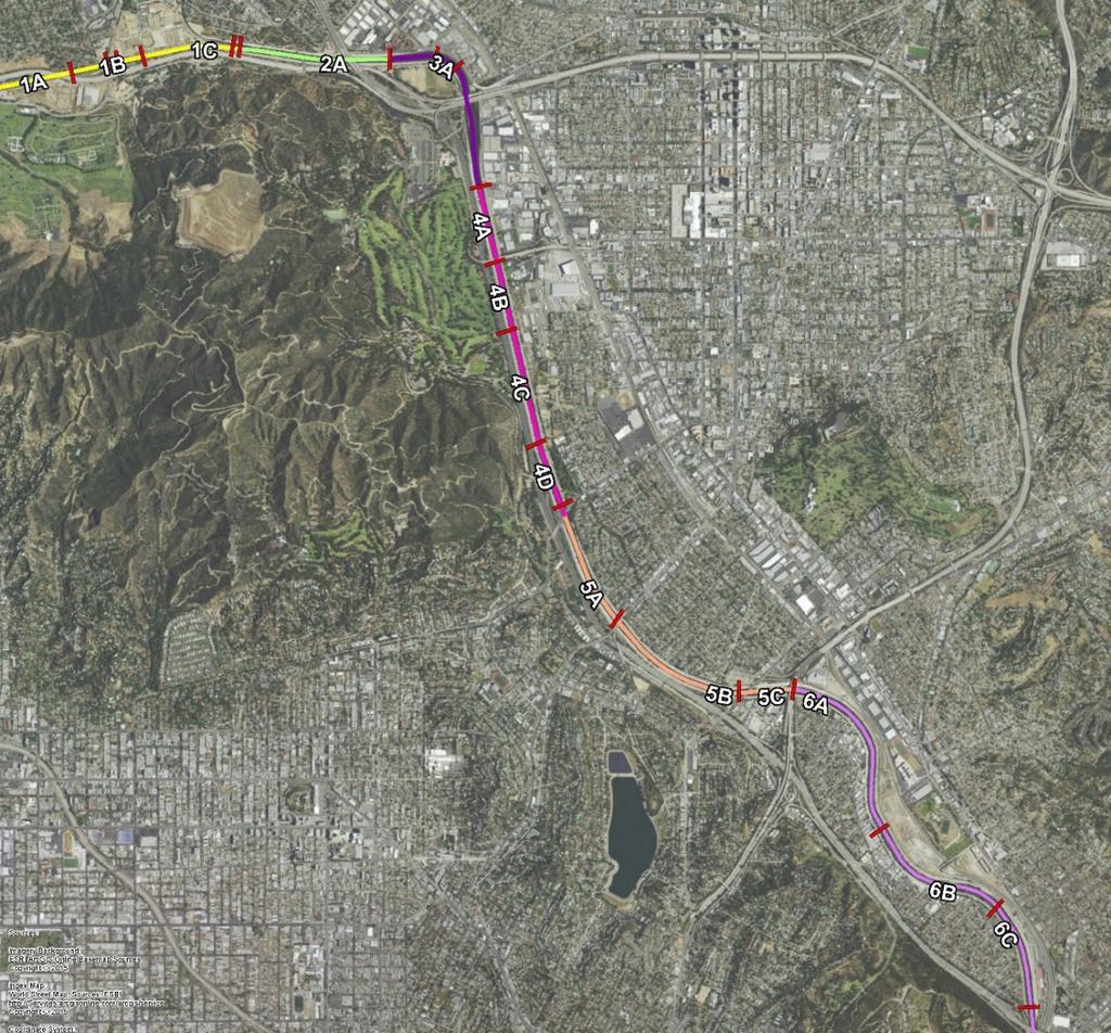
4 The Corps has a portion of O&M responsibility for the Los Angeles County Drainage Area (LACDA) Project. Corps O&M responsibility includes 5 dams, one debris basin and 45 miles of channel. The upper Los Angeles River area depicted in the blue circle is referred to locally as Glendale Narrows. 4

5 View upstream from above Victory Boulevard showing breaches in paved levees. River mile Post-March 1938 Storm 5
6 It doesn t rain in Southern California. -The Average Resident The Los Angeles County Drainage Area Project was constructed in the 1930s and 1940s. Urbanization has significantly changed the amount of runoff and water flow into the Los Angeles River. The as-built capacity of the reaches in Glendale Narrows vary between 40,000-90,000 cfs, which equates roughly to the 7 year-60 year storm event. Congestion from sediment and vegetation has significantly impacted conveyance capacity in the LA River. 6
7 7
8 Reach Design Existing/Pre Improvement With Barriers Non-native vegetation 1 All vegetation and sediment removal 1C 40,000 (12-yr) 43,000 (15-yr) 43,000 (15-yr) 2A 40,000 (7-yr) 25,800 (3-yr) 40,000 (7-yr) 3A 40,000 (7-yr) 4A 78,000 (51-yr) 34,700 (4-yr) 59,900 (20-yr) 4B 78,000 (51-yr) 34,700 (4-yr) 59,900 (20-yr) 4C 78,000 (51-yr) 40,500 (5-yr) 59,900 (20-yr) 4D 78,000 (51-yr) 43,500 (7-yr) 65,800 (25-yr) 5A 78,000 (51-yr) 43,500 (7-yr) 65,800 (25-yr) 5B 78,000 (51-yr) 43,500 (7-yr) 59,900 (20-yr) 5C 78,000 (51-yr) 43,500 (7-yr) 43,500 (7-yr) 6A 83,700 (57-yr) 51,500 (12-yr) 51,500 (12-yr) 6B 83,700 (57-yr) 44,400 (7-yr) 44,400 (7-yr) 6C 83,700 (57-yr) 44,400 (7-yr) 44,400 (7-yr) 1 Non-native vegetation removal including debris and underbrush (No HESCO barriers) 43,000 (15-yr) 43,000 (15-yr) 40,000 (7-yr) 40,000 (7-yr) 49,400 (20-yr) 49,400 (20-yr) 49,400 (20-yr) 49,400 (20-yr) 40,500 (7-yr) 48,200 (10-yr) 43,500 (7-yr) 44,500 (8-yr) 46,000 (9-yr) 48,200 (10-yr) 43,500 (7-yr) 63,000 (20-yr) 56,000 (15-yr) 56,000 (15-yr) 78,000 (51-yr) 78,000 (51-yr) 78,000 (51-yr) 78,000 (51-yr) 78,000 (51-yr) 78,000 (51-yr) 78,000 (51-yr) 83,700 (57-yr) 83,700 (57-yr) 83,700 (57-yr) 8 BUILDING STRONG

9 Downstream View of the Upper Los Angeles River Storm Water Overflow
10 Restoration of conveyance capacity is critical to reducing flood risk for 2,200 residents and approximately 641 structures valued at an estimated $241 million. While an El Nino condition increases the likelihood of successive rain events, the risk of flooding and potential for breakout is the same from year to year. A single large storm event or a few days of significant rain could cause sufficient flow to exceed channel capacity. 10

11 Barriers remain on the west bank in strategic locations. Removal of nearly 3.7 acres of vegetation in the vicinity of Riverside Drive 1.2 native; 2.5 non-native. Vegetation removed is the minimum necessary to relieve potential risk to bridge and surrounding communities. Repair flap gate covers. 11


12 Repair of the concrete toe in Reach 4D (upstream of Los Feliz on both banks). Non-native/invasive species vegetation removal will occur in the areas downstream of Fletcher Drive to the Metrolink train yard. This effort will restore conveyance capacity in the channel. Cost Initial Removal: $28,000 per acre Monthly Maintenance: $4,000 per acre 12

13 Non-native vegetation removal is likely to occur by hand with spraying of herbicide to manage regrowth. Mechanized removal may occur ONLY to the extent that native habitat will not be disturbed. 13
14 Develop and analyze a 2-dimensional hydraulic model to determine if reinstallation of temporary barrier closures is necessary and the conditions upon which closures would be needed. Undertake repairs in the highest priority areas. Develop plans for sediment removal. Continue vegetation management to restore/maintain conveyance capacity. Coordination with local governments and first responders to synchronize monitoring and other flood watch activities. 14 BUILDING STRONG
15 15
 and restore access on the east bank.")
16 Corps staff worked hour days 6 days a week beginning in May to remove all barriers on the bike path (west bank) and restore access on the east bank. Barriers were removed by June 15 th 16
17 Complete removal of all barriers and replacement of the barriers upon short notice is not feasible due to financial and resource constraints. Strategic removal occurred in order to enableremoval of all temporary barriers will expose the entire east bank to flood risk. If needed, the Corps is prepared to implement closures on the east bank with sufficient notice. Materials are currently stockpiled for this effort. 17
18 The Corps works closely with local entities: police, fire, local governments, non-profit organizations and community groups, to address health and safety concerns arising from the presence of homeless encampments in the Los Angeles River. Subject to the availability of resources, the Corps assists in debris and removal after law enforcement entities ensure adequate notice and relocation of individuals. 18
19 The channel was designed without measures for public access/use; no exit structures and no warning system. High flows in channel can occur suddenly and without warning even during the summer, or dry season. The river area is generally closed to public use due to operational issues and safety concerns except where we have a coordinated program for permitted recreation. 19
20 Seasonal recreation in the Los Angeles River adjacent to Elysian Valley is authorized as part of a coordinated effort between the Corps, MRCA, City, County to provide: Recreational Season 2016: Memorial Day to September 25 Although recreation is permitted, the Corps encourages the public to be cognizant of the safety risks. Please be aware of your surroundings. We discourage playing Pokemon Go on or near the channel. 20
21 INFORMATION IS AVAILABLE ON OUR WEBSITE AT: QUESTIONS MAY BE DIRECTED TO: 21


22 The Corps relied upon floodplain mapping that was developed for the LA River Eco Study. For the purposes of developing interim risk reduction measures, the Corps analyzed the potential effects of the 4% annual chance of exceedance floodplain map. 22
PRESENTATION FOR THE POTENTIAL ADDITION OF SPECIAL FLOOD HAZARD AREAS
 PRESENTATION FOR THE POTENTIAL ADDITION OF SPECIAL FLOOD HAZARD AREAS 1 255 255 255 237 237 237 217 217 217 200 200 200 Part 1: Summary of Floodplain Analysis for Los 0 Angeles 163 131 River239 110 112
LOWER BOISE RIVER INTERIM FEASIBILITY STUDY
 LOWER BOISE RIVER INTERIM FEASIBILITY STUDY Public Information Meetings June 29, 2010 June 30, 2010 July 1, 2010 US Army Corps of Engineers BUILDING STRONG Agenda Introductions / Meeting Objectives Greg
Lower San Joaquin River Feasibility Study PLAN FORMULATION ADDENDUM
 PLAN FORMULATION ADDENDUM Non-Structural Measure Descriptions Elevate Critical Infrastructure This measure would raise at-risk critical structures above the design inundation level. Elevation would be
CHAPTER 7. San Dieguito River Flooding Adaptation
 CHAPTER 7 San Dieguito River Flooding Adaptation This chapter includes a range of adaptation measures to address vulnerabilities from flooding along the San Dieguito River, including the river valley,
SANTA ANA RIVER/ SAN TIMOTEO CREEK 1 LEVEE SYSTEM SAN BERNARDINO COUNTY, CALIFORNIA NLD SYSTEM ID #
 SANTA ANA RIVER/ SAN TIMOTEO CREEK 1 LEVEE SYSTEM SAN BERNARDINO COUNTY, CALIFORNIA NLD SYSTEM ID # 3805030015 PERIODIC INSPECTION REPORT NO. 1 GENERALIZED EXECUTIVE SUMMARY FINAL SYSTEM RATING: UNACCEPTABLE
Presentation Overview
 Little Dry Creek Restoration Deep River Flood Risk Management Final Presentation to LCRBDC June 10, 2015 Presentation Overview Project Overview & Background Information Data Collection Model Development
Natural Hazards Mitigation Plan Kankakee County, Illinois Executive Summary
 1. Introduction Natural Hazards Mitigation Plan Kankakee County, Illinois Executive Summary Kankakee County s first Natural Hazards Mitigation Plan was adopted by the Kankakee County Board on October 11,
Appendix G Preliminary Hydrology Study
 Appendix G Preliminary Hydrology Study Preliminary Hydrology Study VESTING TTM 72608 Long Beach, CA Prepared for: The Long Beach Project, LLC 888 San Clemente, Suite 100 New Port Beach, CA May 28, 2014
ATTACHMENT N ASSESSMENT OF PROGRAM EFFECTIVENESS
 ATTACHMENT N ASSESSMENT OF PROGRAM EFFECTIVENESS [This page has been left blank intentionally] Assessment of Program Effectiveness 1. Assessment of your agency's compliance with permit requirements, based
Ponds. Pond A water impoundment made by excavating a pit, or constructing a dam or an embankment.
 POND SITE SELECTION AND CONSTRUCTION Uses, Planning, & Design David Krietemeyer Area Engineer USDA-NRCS June 20, 2008 Uses Considerations for Location of Commonly Used Terms Pond A water impoundment made
LOS ANGELES RIVER/RIO HONDO DIVERSION 2 LEVEE SYSTEM LOS ANGELES COUNTY, CALIFORNIA NLD SYSTEM ID #
 LOS ANGELES RIVER/RIO HONDO DIVERSION 2 LEVEE SYSTEM LOS ANGELES COUNTY, CALIFORNIA NLD SYSTEM ID # 3805010047 PERIODIC INSPECTION REPORT NO 1 GENERALIZED EXECUTIVE SUMMARY FINAL SYSTEM RATING: UNACCEPTABLE
SAN GABRIEL RIVER/ COYOTE CREEK 2 LEVEE SYSTEM LOS ANGELES COUNTY, CALIFORNIA NLD SYSTEM ID #
 SAN GABRIEL RIVER/ COYOTE CREEK 2 LEVEE SYSTEM LOS ANGELES COUNTY, CALIFORNIA NLD SYSTEM ID # 3805010031 PERIODIC INSPECTION REPORT NO. 2 GENERALIZED EXECUTIVE SUMMARY FINAL SYSTEM RATING: MINIMALLY ACCEPTABLE
CHAPTER 9 DISCUSSIONS, CONCLUSIONS, AND RECOMMENDATIONS
 CHAPTER 9 DISCUSSIONS, CONCLUSIONS, AND RECOMMENDATIONS This chapter summarizes the results of feasibility level investigations undertaken to identify solutions to the water and related land resource problems
June 22, Francis E. Borcalli, P.E.
 CACHE CREEK SETTLING BASIN SYMPOSIUM Managing the Settling Basin Who s Doing What! June 22, 2009 Francis E. Borcalli, P.E. CACHE CREEK SETTLING BASIN SYMPOSIUM Managing the Settling Basin Who s Doing What!
APPENDIX A. Project Scoping
 APPENDIX A Project Scoping Notice of Preparation To: From: Agencies and Interested Parties Paul Brunner, Executive Director, Three Rivers Levee Improvement Authority Date: June 13, 2006 Subject: Notice
Good morning, Chairman Yaw, Chairman Yudichak, Chairman Vulakovich, Chairman Costa,
 Testimony of Patrick McDonnell, Secretary Pennsylvania Department of Environmental Protection Joint Hearing on Flooding and Emergency Response Senate Environmental Resources & Energy and Veterans Affairs
LOS ANGELES RIVER/RIO HONDO DIVERSION 2 LEVEE SYSTEM LOS ANGELES COUNTY, CALIFORNIA NLD SYSTEM ID #
 LOS ANGELES RIVER/RIO HONDO DIVERSION 2 LEVEE SYSTEM LOS ANGELES COUNTY, CALIFORNIA NLD SYSTEM ID # 3805010047 PERIODIC INSPECTION REPORT NO 1 GENERALIZED EXECUTIVE SUMMARY FINAL SYSTEM RATING: UNACCEPTABLE
SECTION 7.0 PROJECT FEASIBILITY, ENGINEER S RECOMMENDATION AND DESIGN ISSUES NEEDING RESOLUTION
 SECTION 7.0 PROJECT FEASIBILITY, ENGINEER S RECOMMENDATION AND DESIGN ISSUES NEEDING RESOLUTION 7.1 PROJECT FEASIBILITY The determination of project feasibility is based upon several criteria established
Friant Dam and Millerton Reservoir
 San Joaquin River Restoration Program Floodplain Management Association Presentation SJRRP Update Continued: Impacts from Subsidence April 18, 2013 1 Friant Dam and Millerton Reservoir Completed in 1942
DALLAS FLOODWAY PROJECT
 DALLAS FLOODWAY PROJECT DRAFT FEASIBILITY REPORT and DRAFT ENVIRONMENTAL IMPACT STATEMENT PUBLIC MEETING Rob Newman Director, Trinity River Corridor Project, Fort Worth District 8 May 2014 US Army Corps
3.0 CUMULATIVE PROJECTS SCENARIO
 3.0 CUMULATIVE PROJECTS SCENARIO The CEQA Guidelines define cumulative impacts as two or more individual effects that, when considered together, are considerable or which compound or increase other environmental
Stormwater Programs. BIA Meeting June 5, Jason Uhley
 Stormwater Programs BIA Meeting June 5, 2014 Jason Uhley Chief of Watershed Protection Riverside County Flood Control and Water Conservation District Presentation Outline Clean Water Act Stormwater Program
HYDROLOGY REPORT HEACOCK & CACTUS CHANNELS MORENO VALLEY, CALIFORNIA NOVEMBER 2005 REVISED APRIL 2006 REVISED AUGUST 2006
 HYDROLOGY REPORT HEACOCK & CACTUS CHANNELS MORENO VALLEY, CALIFORNIA NOVEMBER 2005 REVISED APRIL 2006 REVISED AUGUST 2006 RIVERSIDE COUNTY FLOOD CONTROL AND WATER CONSERVATION DISTRICT TABLE OF CONTENTS
Hydrology and Flooding
 Hydrology and Flooding Background The 1996 flood Between February 4, 1996 and February 9, 1996 the Nehalem reporting station received 28.9 inches of rain. Approximately 14 inches fell in one 48 hour period.
NOTICE OF PREPARATION
 NOTICE OF PREPARATION Date: June 12, 2014 To: From: Subject: Governor s Office of Planning and Research/State Clearinghouse Unit, Responsible Agencies, Trustee Agencies, and Interested Parties Announcement
Kern Water Bank. Kern Water Bank Authority
 Kern Water Bank Kern Water Bank Authority THE KERN WATER BANK Ensuring a Reliable Water Supply to the Southern San Joaquin Valley Providing for Exceptional Upland and Riparian Habitat Kern Water Bank Authority
John H. Kerr Dam and Reservoir Virginia and North Carolina (Section 216)
") John H. Kerr Dam and Reservoir Virginia and North Carolina (Section 216) Wilmington District, Corps of Engineers Stakeholder Update Presentation January 24, 2014 Authorized under Section 216 of Public
John H. Kerr Dam and Reservoir Virginia and North Carolina (Section 216) Wilmington District, Corps of Engineers Stakeholder Update Presentation January 24, 2014 Authorized under Section 216 of Public
COON CREEK WATERSHED DISTRICT PERMIT REVIEW. Spring Lake Park Schools Westwood Middle School st Avenue NE, Spring Lake Park, MN 55432
 PAN 16-112, Westwood Middle School, Page 1 of 6 COON CREEK WATERSHED DISTRICT PERMIT REVIEW MEETING DATE: August 22, 2016 AGENDA NUMBER: 10 FILE NUMBER: 16-112 ITEM: Westwood Middle School RECOMMENDATION:
ENGINEERING REPORT ANALYSIS OF CLOSURES. HOUSATONIC RIVER and NAUGATUCK RIVER FLOOD PROTECTION PROJECTS SECTION 1. ANSONIA and DERBY, CONNECTICUT
 ENGINEERING REPORT ANALYSIS OF CLOSURES HOUSATONIC RIVER and NAUGATUCK RIVER FLOOD PROTECTION PROJECTS SECTION 1 ANSONIA and DERBY, CONNECTICUT December 2010 MMI #1560-119 and #3118-03 Prepared for: City
Fort Leonard Wood, Missouri. September 2013
 Fort Leonard Wood, Missouri September 2013 1 Presenters Shannon Kelly, Physical Scientist Clean Water Act Program Manager Directorate of Public Works Environmental Division Environmental Compliance Branch
Farmington Dam Repurpose Project
 Farmington Dam Repurpose Project 2017 $158,100,000 to re-purpose the Farmington Dam from flood protection only to a long-term water storage facility that increases water supply reliability to the region.
STORMWATER HARVESTING FOR ALTERNATIVE WATER SUPPLY IN VOLUSIA COUNTY, FLORIDA
 STORMWATER HARVESTING FOR ALTERNATIVE WATER SUPPLY IN VOLUSIA COUNTY, FLORIDA Lena Rivera, P.E., D.WRE (CDM); Lee P. Wiseman, P.E., BCEE (CDM); Scott Mays, P.E. (Volusia County); and George Recktenwald
SAFETY AND NOISE 9. Safety and Noise
 SAFETY AND NOISE 9 9 Safety and Noise Safety is a basic human need and is required for a community to thrive. The goals and policies in this element are designed to protect and enhance public health and
LOWER CACHE CREEK, YOLO COUNTY WOODLAND AREA FEASIBILITY STUDY
 Background LOWER CACHE CREEK, YOLO COUNTY WOODLAND AREA FEASIBILITY STUDY Energy and Water Development Appropriations Act of 1993 Reconnaissance Study completed June 1994 Feasibility Cost Share Agreement
Appendix D - Evaluation of Interim Solutions
 Appendix D - Evaluation of Interim Solutions D.1 Introduction The implementation of long-term improvements is projected to take 5 to 8 years. To reduce the number of years of flooding impacts, the partner
CITY OF REDLANDS MASTER PLAN OF DRAINAGE San Bernardino County, California
 CITY OF REDLANDS MASTER PLAN OF DRAINAGE San Bernardino County, California Prepared for City of Redlands 35 Cajon Street Redlands, California 92373 Prepared by 14725 Alton Parkway Irvine, CA 92618 Contact
Project Alignment Appendix A
 Project Alignment Appendix A Fargo Moorhead Metropolitan Area Flood Risk Management Project EA Document This page is intentionally left blank Project Alignment Appendix A Table of Contents 1 BACKGROUND...
King County Flood Control District approves grants for flood prevention projects Regional projects to benefit from district funds
 News Release Contact: Al Sanders 206-477-1016 August 31, 2015 Flood Control District approves grants for flood prevention projects Regional projects to benefit from district funds The Flood Control District
EFFECT OF UPSTREAM DEVELOPMENT ON THE CLEAR CREEK AREA
 EFFECT OF UPSTREAM DEVELOPMENT ON THE CLEAR CREEK AREA Technical Memorandum Farming in the Floodplain Project Prepared for May 2017 PCC Farmland Trust Photo credit: Google Earth TABLE OF CONTENTS Page
Floods of 2008 Urban Systems Wayne Petersen, Urban Conservationist, IDALS. What lessons did we learn? (or should have learned)
") Floods of 2008 Urban Systems Wayne Petersen, Urban Conservationist, IDALS What lessons did we learn? (or should have learned) 100 year storms and 100 year floodplains are not a good standard for the future
Floods of 2008 Urban Systems Wayne Petersen, Urban Conservationist, IDALS What lessons did we learn? (or should have learned) 100 year storms and 100 year floodplains are not a good standard for the future
Informational Meeting- July 21, Boxelder B-2/B-3 Watershed Planning Study
 Informational Meeting- July 21, 2015 Boxelder B-2/B-3 Watershed Planning Study Agenda Introductions Background & History Purpose & Need NRCS Watershed Planning Program Work Completed to Date Longer term
HYDROLOGY STUDY LA MIRADA BOULEVARD La Mirada, California
 HYDROLOGY STUDY 12000 LA MIRADA BOULEVARD La Mirada, California TTM 73119 Prepared for: The Olson Company 3010 Old Ranch Parkway, Suite 100 Seal Beach, CA 90740 Contact: Mr. Aaron Orenstein (562) 370-9531
Lessons [being] learnt 2016 Flood in Cedar Rapids. Sandy Pumphrey Project Engineer II Flood Mitigation
![Lessons [being] learnt 2016 Flood in Cedar Rapids. Sandy Pumphrey Project Engineer II Flood Mitigation](/thumbs/77/74998790.jpg "Lessons [being] learnt 2016 Flood in Cedar Rapids. Sandy Pumphrey Project Engineer II Flood Mitigation") Lessons [being] learnt 2016 Flood in Cedar Rapids Sandy Pumphrey Project Engineer II Flood Mitigation 319 286 5363 s.pumphrey@cedar-rapids.org Agenda 2008 Flood Event 2016 Flood Event [Long Term] Flood
Lessons [being] learnt 2016 Flood in Cedar Rapids Sandy Pumphrey Project Engineer II Flood Mitigation 319 286 5363 s.pumphrey@cedar-rapids.org Agenda 2008 Flood Event 2016 Flood Event [Long Term] Flood
UMD Storm Water Program Construction Requirements. Greg Archer, MBA Environmental Compliance Specialist
 UMD Storm Water Program Construction Requirements Greg Archer, MBA Environmental Compliance Specialist Phase 2 Regulatory Overview Dec. 1999 EPA issues Phase 2 Federal Register Municipalities (MS4) from
US Army Corps of Engineers
 I I I ' A I US Army Corps of Engineers LA River Ecosystem Restoration, CA Preconstruction Engineering and Design Phase 104791 LOS ANGELES DISTRICT SOUTH PACIFIC DIVISION August 15, 2017 1 Table of Contents
In support of an alternative water supply
 FWRJ Stormwater Harvesting for Alternative Water Supply in Volusia County Lena Rivera, Lee P. Wiseman, Scott Mays, and George Recktenwald In support of an alternative water supply plan for Volusia County
HYDRAULIC HYDRODYNAMIC MODELING AS AN EFFECTIVE MANAGEMENT TOOL FOR LARGE COLLECTION SYSTEMS - THE L.A. STORY
 HYDRAULIC HYDRODYNAMIC MODELING AS AN EFFECTIVE MANAGEMENT TOOL FOR LARGE COLLECTION SYSTEMS - THE L.A. STORY Fernando Gonzalez, Adel Hagekhalil, Bryan Trussell, City of Los Angeles Bureau of Sanitation
Association of State Floodplain Managers May 2, 2017 Rob Davis, P.E., ENVSP Flood Control System Program Manager
 Association of State Floodplain Managers May 2, 2017 Rob Davis, P.E., ENVSP Flood Control System Program Manager 2008 vs. 2016 Cedar Rapids Population 130,000 Second largest city in Iowa Industrial roots:
Rainy Season Preparation & Storm Channel Maintenance
 Rainy Season Preparation & Storm Channel Maintenance City Efforts Thorough Review of the storm water system Documentation of system conditions Now part of selection criteria or maintenance Full public
Chapter 4. Drainage Report and Construction Drawing Submittal Requirements
 4.0 Introduction The requirements presented in this section shall be used to aid the design engineer or applicant in the preparation of drainage reports, drainage studies, and construction drawings for
RECORD OF DECISION I. INTRODUCTION
 RECORD OF DECISION As the District Commander for the Los Angeles District, I have reviewed the Final Environmental Impact Statement/Environmental Impact Report (EIS/EIR) for the Newhall Ranch Resource
UNIVERSITY OF OREGON NORTH CAMPUS CONDITIONAL USE PERMIT PROJECT Draft Conditional Use Permit Stormwater, Sanitary Sewer, and Water Analysis Report
 UNIVERSITY OF OREGON NORTH CAMPUS CONDITIONAL USE PERMIT PROJECT Draft Conditional Use Permit Stormwater, Sanitary Sewer, and Water Analysis Report Prepared for: Cameron McCarthy Landscape Architects LLP
NEW CASTLE CONSERVATION DISTRICT. through. (Name of Municipality) PLAN REVIEW APPLICATION DRAINAGE, STORMWATER MANAGEMENT, EROSION & SEDIMENT CONTROL
 PLAN REVIEW APPLICATION DRAINAGE, STORMWATER MANAGEMENT, EROSION & SEDIMENT CONTROL") NEW CASTLE CONSERVATION DISTRICT through (Name of Municipality) PLAN REVIEW APPLICATION DRAINAGE, STORMWATER MANAGEMENT, EROSION & SEDIMENT CONTROL Office use only: Received by Municipality: Received by
NEW CASTLE CONSERVATION DISTRICT through (Name of Municipality) PLAN REVIEW APPLICATION DRAINAGE, STORMWATER MANAGEMENT, EROSION & SEDIMENT CONTROL Office use only: Received by Municipality: Received by
POLICY FOR NATURAL RESOURCE MANAGEMENT AREAS
 POLICY FOR NATURAL RESOURCE MANAGEMENT AREAS I. POLICY STATEMENT Auburn University's (the University's) "Policy for Natural Resource Management Areas" implements the Campus Master Plan Land Use Element
BCWMC Capital Improvement Program (approved April 19, 2018; pending minor Plan amendment)
") BCWMC Capital Improvement Program 2020 2024 (approved April 19, 2018; pending minor Plan amendment) Project Name City Number 2019 2020 2021 2022 2023 2024 2025 Totals Medicine Lake Rd and Winnetka Ave
BCWMC Capital Improvement Program 2020 2024 (approved April 19, 2018; pending minor Plan amendment) Project Name City Number 2019 2020 2021 2022 2023 2024 2025 Totals Medicine Lake Rd and Winnetka Ave
CHAPTER 3 Environmental Guidelines for WATERCOURSE CROSSINGS GOVERNMENT OF NEWFOUNDLAND AND LABRADOR DEPARTMENT OF ENVIRONMENT AND LABOUR
 GOVERNMENT OF NEWFOUNDLAND AND LABRADOR DEPARTMENT OF ENVIRONMENT AND LABOUR CHAPTER 3 Environmental Guidelines for WATERCOURSE CROSSINGS WATER RESOURCES MANAGEMENT DIVISION Water Investigations Section
Revised 8-4. Board of Directors Water Planning and Stewardship Committee. September 11, 2007 Board Meeting. Subject. Description
 Board of Directors Water Planning and Stewardship Committee September 11, 2007 Board Meeting Subject Adopt criteria for conveyance options in implementation of Long Term Delta Plan Description Revised
DES MOINES RIVER RESERVOIRS WATER CONTROL PLAN UPDATES IOWA ASCE WATER RESOURCES DESIGN CONFERENCE
 DES MOINES RIVER RESERVOIRS WATER CONTROL PLAN UPDATES 237 237 237 217 217 217 200 200 200 0 0 0 163 163 163 131 132 122 80 119 27 252 174.59 110 135 120 112 92 56 IOWA ASCE WATER RESOURCES DESIGN CONFERENCE
THE CROSSROADS IN WINCHESTER 4. DRAINAGE PLAN. 4. Drainage Plan. a. Drainage Plan Description
 THE CROSSROADS IN WINCHESTER 4. DRAINAGE PLAN 4. Drainage Plan a. Drainage Plan Description The Specific Plan area drains naturally into two separate watersheds: approximately 6 percent of the Specific
PRESENTERS. Contact Information: RW Armstrong Union Station, 300 S. Meridian St. Indianapolis, IN
 1 PRESENTERS David Bourff, Director of Environmental Planning Simon Davies, LEED AP, Environmental Scientist Summer O Brien, PWS, Senior Environmental Scientist Contact Information: RW Armstrong Union
III. INVENTORY OF EXISTING FACILITIES
 III. INVENTORY OF EXISTING FACILITIES Within the Growth Management Boundary, the existing storm drainage facilities are largely associated with development that has historically occurred in the ten drainage
FY16 RSM IPR Portland District, Optimizing Fall Creek Reservoir Flush TMDL s, Stanford Gibson, Chris Nygaard, Jim Crain, Jarod Norton
 Fall Creek Reservoir Fall Creek Dam is at river mile 7.2 on Fall Creek, a tributary of the Willamette River, about 20 miles southeast of Eugene, OR. Dam works in coordination with Lookout Point and Hills
Supplemental Watershed Plan Agreement No. 10 for Neshaminy Creek Watershed Core Creek Dam (PA-620) Bucks County, Pennsylvania
 Bucks County, Pennsylvania") Supplemental Watershed Plan Agreement No. 10 for Neshaminy Creek Watershed Core Creek Dam (PA-620) Bucks County, Pennsylvania Project Authorization USDA's Small Watershed Program is carried out under the
Supplemental Watershed Plan Agreement No. 10 for Neshaminy Creek Watershed Core Creek Dam (PA-620) Bucks County, Pennsylvania Project Authorization USDA's Small Watershed Program is carried out under the
Hydrologic Study Report for Single Lot Detention Basin Analysis
 Hydrologic Study Report for Single Lot Detention Basin Analysis Prepared for: City of Vista, California August 18, 2006 Tory R. Walker, R.C.E. 45005 President W.O. 116-01 01/23/2007 Table of Contents Page
Fullerton Creek Channel (OCFCD Facility No. A03) from downstream Beach Blvd. including undercrossing to downstream I-5 Freeway.
 from downstream Beach Blvd. including undercrossing to downstream I-5 Freeway.") Fullerton Creek Channel (OCFCD Facility. A03) Lead Agency: Agency: Project Director: Address: Orange County, Public Works, Infrastructure Programs, Capital Programs Sam Ali 300 N. Flower Street Santa Ana
Fullerton Creek Channel (OCFCD Facility. A03) Lead Agency: Agency: Project Director: Address: Orange County, Public Works, Infrastructure Programs, Capital Programs Sam Ali 300 N. Flower Street Santa Ana
SECTION 11: REGULATORY FLOODWAYS
 SECTION 11: REGULATORY FLOODWAYS Contents 11.1. The Floodway... 11-2 11.1.1. The floodway concept... 11-2 11.1.2. Floodway map... 11-2 11.1.3. Floodway permitting... 11-3 11.1.4. Changing the floodway...
Project Goals and Scoping
 Prepared for: Boulder County, Colorado Flood Planning & Preliminary Design Services for South St. Vrain Creek Restoration at Hall Ranch and Scoping May 24, 2016 Meeting with General Public In association
Westside Water Quality Treatment Project Proposition 13 Photo Diary Final Report March /31/02 QMM02B
 Westside Water Quality Treatment Project Proposition 13 Photo Diary Final Report March 2008 Southern California Region Westside Water Quality Treatment Project Project Objective: Design and construct a
Moving Forward Suggestions for Reducing the Destructive Lake Discharges to the Estuaries
 Moving Forward Suggestions for Reducing the Destructive Lake Discharges to the Estuaries Gary Goforth April 2014 Moving Forward Commend Corps and District for holding Lessons Learned workshops to identify
OVERVIEW OF RESERVOIR OPERATIONS AND FLOOD RISK MANAGEMENT
 OVERVIEW OF RESERVOIR OPERATIONS AND FLOOD RISK MANAGEMENT 255 255 255 237 237 237 0 0 0 217 217 217 163 163 163 200 200 200 COLUMBIA RIVER BASIN 131 132 122 239 65 53 80 119 27 110 135 120 252 174.59
PRELIMINARY DRAINAGE REPORT NEWCASTLE FIRE STATION OLD STATE HIGHWAY
 PRELIMINARY DRAINAGE REPORT FOR THE NEWCASTLE FIRE STATION OLD STATE HIGHWAY PREPARED FOR THE NEWCASTLE FIRE PROTECTION DISTRICT JULY 2014 BY ROSEVILLE DESIGN GROUP, INC. ROSEVILLE DESIGN GROUP, Inc Established
SOUTH FLORIDA WATER MANAGEMENT DISTRICT. Question 13: Wetlands
 SOUTH FLORIDA WATER MANAGEMENT DISTRICT Question 13: Wetlands 1. The wetland responses and topographical data provided in the ADA for the 520- acre project site are conceptual in nature. The referenced
RIPARIAN CORRIDOR STUDY FINAL CITY CREEK MANAGEMENT PLAN TABLE OF CONTENTS
 TABLE OF CONTENTS 1.0 INTRODUCTION... 1-1 Riparian Corridor Study and Management Plan Goals... 1-1 Study Area... 1-2 Importance and Functions of Riparian Corridors... 1-2 Habitat for Mammals, Birds, and
RIVERSIDE OXBOW FORT WORTH, TEXAS CHAPTER 3 IDENTIFICATION OF PROBLEMS AND OPPORTUNITIES
 RIVERSIDE OXBOW FORT WORTH, TEXAS CHAPTER 3 IDENTIFICATION OF PROBLEMS AND OPPORTUNITIES Regular study team meetings were held with the Tarrant Regional Water District, the USFWS, Streams and Valleys,
Chehalis Basin Strategy Programmatic SEPA Draft EIS
 Chehalis Basin Strategy Programmatic SEPA Draft EIS History of Flooding I-5 closed in 1990, 1996, 2007, 2009 Five largest flood events occurred since 1986 2 History of Habitat Degradation Harvest has been
Chapter 9 Wetlands Park Study Team
 Chapter 9 Wetlands Park Study Team Objective How can we help Clark County facilitate implementation of the Clark County Wetlands Park Master Plan, and provide for the management of various ecosystems within
City of Fairmont Storm Water Pollution Prevention Plan (SWPPP) January 23, 2017
 January 23, 2017") City of Fairmont Storm Water Pollution Prevention Plan (SWPPP) January 23, 2017 Why is Water Quality Important? Water has always been important to Minnesota and is a key part of our history, culture, economy
City of Fairmont Storm Water Pollution Prevention Plan (SWPPP) January 23, 2017 Why is Water Quality Important? Water has always been important to Minnesota and is a key part of our history, culture, economy
Municipal Stadium Wetland
 W A T E R S H E D F A C T S Total watershed area 140 mi 2 Average annual rainfall 38 in Average annual temperature 58 F Elevation Max 1321 ft Min 899 ft C. J. Brown Reservoir controls flow from 83 mi 2
Sediment Basin. Fe= (Depends on soil type)
") 3.9 Sediment Control Description: A sediment basin is an embankment with a controlled outlet that detains stormwater runoff, resulting in the settling of suspended sediment. The basin provides treatment
3.9 Sediment Control Description: A sediment basin is an embankment with a controlled outlet that detains stormwater runoff, resulting in the settling of suspended sediment. The basin provides treatment
Los Angeles 3 rd Regional
 Los Angeles 3 rd Regional Investors Conference Los Angeles, California March 31, 2016 Metropolitan Water District of Southern California 1 Metropolitan Water District of of Southern California 2 Metropolitan
Table D-1. Montour County Hazard Mitigation Projects - Municipalities Affected. Structural Projects
 Table D-1 Montour County Hazard Mitigation Projects - Municipalities Affected Structural Projects Project Description Mitigation Objective Hazard Municipality(s) Affected Pursue re-mapping of the 100-year
How can rivers be managed?
 How can rivers be managed? To be able to identify different management strategies, distinguishing between hard and soft engineering (4-5) To be able to give the advantages and disadvantages of different
CEQA Scoping Meeting. West Desert Hot Springs Master Drainage Plan Program Environmental Impact Report
 CEQA Scoping Meeting West Desert Hot Springs Master Drainage Plan Program Environmental Impact Report CEQA Lead Agency: City of Desert Hot Springs January 8, 2014 Scoping Meeting Agenda 1. Welcome and
Fargo-Moorhead Metropolitan Area Flood Risk Management Project
 Fargo-Moorhead Metropolitan Area Flood Risk Management Project 52ND ANNUAL IOWA ASCE ENVIRONMENTAL & WATER RESOURCES CONFERENCE 03 April 2014 Aaron W. Buesing Senior Hydraulic Engineer Corps of Engineers,
KESWICK DAM RED BLUFF REACH
 Chapter 3 KESWICK DAM RED BLUFF REACH The Keswick-Red Bluff Reach of the Sacramento River, the upper-most reach of the Conservation Area, is unique in many ways. The reach extends from Keswick Dam (about
Hydropower Project License Summary PIT RIVER, CA PIT 1 HYDROELECTRIC PROJECT (P-2687) Pit River below Pit 1 Powerhouse
 Pit River below Pit 1 Powerhouse") Hydropower Project License Summary PIT RIVER, CA PIT 1 HYDROELECTRIC PROJECT (P-2687) Pit River below Pit 1 Powerhouse Photo: Hydropower Reform Coalition This summary was produced by the Hydropower Reform
Hydropower Project License Summary PIT RIVER, CA PIT 1 HYDROELECTRIC PROJECT (P-2687) Pit River below Pit 1 Powerhouse Photo: Hydropower Reform Coalition This summary was produced by the Hydropower Reform
Phase II Report on Hydrology, Hydraulics, and Low Water Dams
 Phase II Report on Hydrology, Hydraulics, and Low Water Dams Arkansas River Corridor Tulsa, OK May 2005 Submitted To: U. S. Army Corps of Engineers Tulsa District Prepared by: The GUERNSEY Team 5555 N.
GIWW Brazos River Floodgates and Colorado River Locks Feasibility Study
 GIWW Brazos River Floodgates and Colorado River Locks Feasibility Study Stakeholder Partnering Forum Modernizing of the GIWW August 4, 2016 Partnering Under a Systems Approach for Sustaining Commercial
Environmental Protection (NJDEP) The Louis Berger Group, Inc.
 The Louis Berger Group, Inc.") Hydraulic Modeling for Preliminary Evaluation of Potential Flooding Impacts for Various Dredging, Capping and Armoring Scenarios of The Lower Passaic River Restoration Abdulai Fofanah, PE, D.WRE, CFM Murat
Hydraulic Modeling for Preliminary Evaluation of Potential Flooding Impacts for Various Dredging, Capping and Armoring Scenarios of The Lower Passaic River Restoration Abdulai Fofanah, PE, D.WRE, CFM Murat
Hydrologic and Ecologic Impacts from the CERP Indian River Lagoon South Project
 Hydrologic and Ecologic Impacts from the CERP Indian River Lagoon South Project Dr. Gretchen Ehlinger Senior Biologist US Army Corps of Engineers Jacksonville District November 15, 2016 AWRA Conference
PART 3 - STANDARDS FOR SEWERAGE FACILITIES DESIGN OF STORM SEWERS
 PART 3 - STANDARDS FOR SEWERAGE FACILITIES 3.3 - DESIGN OF STORM SEWERS 3.301 Design of Storm Sewers A. General Information B. Investigations and Surveys C. Special Projects 3.302 Design Criteria for Storm
Outcomes. Kelly Karll-SEMCOG Margaret Barondess - MDOT
 Eco-Logical: I-75 Corridor I-75 Conservation Transportation Action Planning in to Monroe Achieve County: Multiple Stormwater Environmental Considerations Outcomes Kelly Karll-SEMCOG Karll@semcog.org Margaret
V. DRAINAGE IMPROVEMENTS
 V. DRAINAGE IMPROVEMENTS 5.1 Formulation of Drainage Improvements As indicated in Chapter 4, following the completion of the hydrologic analysis associated with future land use conditions, drainage improvements
Chapter 3 Dispersion BMPs
 Chapter 3 Dispersion BMPs 3.1 BMP L611 Concentrated Flow Dispersion 3.1.1 Purpose and Definition Dispersion of concentrated flows from driveways or other pavement through a vegetated pervious area attenuates
Construction Best Management Practices Handbook BEST MANAGEMENT PRACTICES
 Construction Best Management Practices Handbook www.montereysea.org BEST MANAGEMENT PRACTICES 26 www.montereysea.org Construction Best Management Practices Handbook VEHICLE TRACKING AND DUST CONTROL IN
Response to Comments of Don and Tricia Nevis (Letter I25) See the master response to Public Outreach Process.
 See the master response to Public Outreach Process.") Freeport Regional Water Authority and the U.S. Department of the Interior, Bureau of Reclamation Chapter 8. Responses to Comments from Individuals Don and Tricia Nevis (I25) Response to Comments of Don
Freeport Regional Water Authority and the U.S. Department of the Interior, Bureau of Reclamation Chapter 8. Responses to Comments from Individuals Don and Tricia Nevis (I25) Response to Comments of Don
RECORD OF DECISION MAY RIO GRANDE FLOODWAY, SAN ACACIA TO BOSQUE DEL APACHE UNIT FLOOD RISK MANAGEMENT PROJECT SOCORRO COUNTY, NEW MEXICO
 RECORD OF DECISION MAY 2 0 2014 RIO GRANDE FLOODWAY, SAN ACACIA TO BOSQUE DEL APACHE UNIT FLOOD RISK MANAGEMENT PROJECT SOCORRO COUNTY, NEW MEXICO The Final General Reevaluation Report and Supplemental
HYDROLOGY STUDY PREPARED FOR: MARKHAM PERRIS LLC 302 WEST FIFTH STREET, SUITE 103 SAN PEDRO, CA (310) FOR THE PROJECT:
 FOR THE PROJECT:") HYDROLOGY STUDY PREPARED FOR: MARKHAM PERRIS LLC 302 WEST FIFTH STREET, SUITE 103 SAN PEDRO, CA 90731 (310) 241-2992 FOR THE PROJECT: PERRIS VALLEY COMMERCE CENTER BUILDING PERRIS, CALIFORNIA PROJECT NUMBER:
HYDROLOGY STUDY PREPARED FOR: MARKHAM PERRIS LLC 302 WEST FIFTH STREET, SUITE 103 SAN PEDRO, CA 90731 (310) 241-2992 FOR THE PROJECT: PERRIS VALLEY COMMERCE CENTER BUILDING PERRIS, CALIFORNIA PROJECT NUMBER:
ND Detention Project Development Update
 ND Detention Project Development Update Upper Red River Basin Halstad, MN = 8 Upstream Subwatersheds Fargo, ND = 3 Upstream Subwatersheds Halstad, MN Fargo, ND Wild Rice Otter Tail Bois de Sioux Upstream