FLOOD CHARACTERISTICS
|
|
|
- Damon Johnston
- 5 years ago
- Views:
Transcription
1

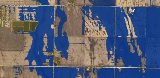
2 simple yet widely accepted modeling approach that uses a constant flow to represent a flooding event, and it is currently the most common tool used for FIS efforts. Modeling for the FM Diversion project uses the same HEC-RAS program, but with an unsteady state approach that analyzes a river system with the entire flood hydrograph. Unsteady state models are capable of producing more realistic flooding results when compared to a steady state model, especially in areas where floodplain storage and hydrograph timing is critical, like it is in the Valley. The city engineering staff recognizes that the unsteady state HEC-RAS model from the FM Diversion modeling is the best model available, therefore it has been chosen to be used for this study to analyze the impacts of future flood mitigation projects. FLOOD CHARACTERISTICS Flooding throughout the study area can be quite complex when breakout flows and reverse flows are observed. Exhibit 2 and the following text further describe the flood patterns throughout the study area. Flood waters upstream of the study area originate in the Wild Rice River and basins which converge upstream of the Fargo/Moorhead area. Floodwaters continue north through Fargo and Moorhead as displayed with white arrows on Exhibit 2. During large flood events, the Wild Rice River will break out into Drain 27 and/or Drain 53. This water then continues north and east until it enters which outlets into the between 40 th Avenue S. and 52 nd Avenue S. The breakout waters are shown with red arrows in Exhibit 2. Near the crest of a flood, floodwaters will back up into, Drain 27 and Drain 53 until flooding levels equalize between the and the currently undeveloped land upstream along Drain 27 and Drain 53. This reverse flow effect was observed by sand bagging volunteers along Drain 27 just before the crest of the 2009 flood. The orange arrows on Exhibit 2 show the reverse flow. Without temporary and permanent flood protection measures (levees and floodwalls) along Drain 27 and Rose Coulee, flooding would break out of the north side of Drain 27 and and flow through the developed portions of the city as displayed with blue arrows in Exhibit 2. FLOODPLAIN IMPACTS EXISTING CONDITIONS FLOODING An existing conditions floodplain assumes no permanent or temporary flood protection measures are in place. The communities have been fortunate to not have had to experience an existing conditions floodplain as described in the FEMA Flood Insurance Rate Map (FIRM), or as described in the FM Diversion modeling. This is attributed to the rigorous flood fighting efforts put forth by the local communities during the recent floods. As displayed in Exhibit 3, the existing conditions floodplain would extend throughout the light blue and dark blue flooded areas. FUTURE CONDITIONS FLOODING For this analysis, it was assumed that future conditions would include flood protection down to approximately 76 th Avenue S. Then, upon levee certification, it is expected that the remaining floodplain would more closely resemble the dark blue flooding shown on Exhibit 3. However, eliminating the light blue floodplain would cause adverse flooding impacts on adjacent areas (dark blue) ST AVE N FARGO, ND PAGE 2 OF 5
3 Floodplain impacts are primarily caused by one or both of the following: 1) Reducing the conveyance in a river corridor (levees/floodwalls) 2) Removing natural storage from a floodplain (fill or levees on previously flooded land) Within the study area, conveyance issues are typically identified along the and Wild Rice River, whereas storage loss is more readily measured in the backwater flooding areas of Drain 27, Drain 53, and Rose Coulee. HYDRAULIC MODELING HEC-RAS 1D MODEL The unsteady state HEC-RAS model (Phase 8) from the FM Diversion project was used as a backbone for this analysis. The model uses cross sections to represent the rivers themselves and storage areas to represent sections of farmland and/or developed areas through town. The model has gone through several internal and external reviews through the FM Diversion project and it has been considered to be the best available large scale model of the. Historic flood events from 1997, 2006, 2009, and 2011 have been used for calibration, and synthetic events such as 10-, 25-, 50-, 100-, and 500-year events have been created for FM Diversion design purposes. The synthetic events utilize the latest hydrology developed for the FM Diversion project. Since the primary objective of the In-Town flood mitigation work through Fargo has been to provide certifiable flood protection, the levees and floodwalls have been designed to protect against the regulatory FEMA floodplain which produces 29,300 cfs (39.3 feet) at the Fargo Gage. Therefore, for this analysis, the 50- year hydrology from the FM Diversion model was adjusted to closely match the FEMA 100-year flood elevation and discharge at the Fargo Gage. The existing conditions unsteady model reflects the flooding that would exist through town if no flood protection measures were implemented. With this model, approximately 4,500 cfs would be expected to flow through the developed portion of town and approximately 24,800 cfs would flow in the channel portion of the. When the flood protection measures are implemented, the north side of Drain 27 and essentially become a wall that prevents floodwaters from flowing north. The floodwaters become restricted to the Red River channel which causes a stage increase, adversely affecting flooding in other areas (Exhibit 3, dark blue). Exhibit 4 further describes the flow distribution between the overland conveyance and the channel conveyance. The impacts are partially attributed to the encroachment along the, but are also a result of removing the floodplain storage in the Drain 27, Drain 53, and areas. Exhibit 5 displays five study areas referred to as zones with the associated floodplain volume removed by implementing the flood protection projects. The proposed solution agreed upon during the planning process was to provide comparable floodplain storage in a condensed location such that the city could further expand south of 52 nd Avenue S. in the remaining available land. The results of the preliminary analysis were presented to the City Commission on September 21, ST AVE N FARGO, ND PAGE 3 OF 5
4 The required mitigation from the preliminary 1D analysis was fairly conceptual, and consisted of the following: 30,000,000 CY of Pond Excavation 15 Miles of Levee 2,000 Acres of Land to be used for Flood Storage Construction = $150M Land = $30M Total Cost = $180M Exhibit 6 displays the potential storage requirements from the initial 1D modeling assuming mitigation ponds would be excavated 10 feet deep. The pond shape and locations were subjectively chosen as a concept. They could be placed almost anywhere along Drain 27 and Drain 53. However, the storage volume becomes less efficient as the distance increases from the existing conditions floodplain area ( area). HEC-RAS 2D MODEL The unsteady state HEC-RAS model as described above uses 1 Dimensional calculations. However, as this study developed, a beta version of HEC-RAS 2D became available, and as of spring 2016, the first official release of HEC-RAS 2D was made available. The 2D model has the capability of accounting for more detail within the city such as building structures, building pads, and roughness of the ground (grass vs. pavement). This provides a more accurate representation of how flood waters would move through the city, potentially slowing down the through town hydrograph. If the hydrograph is slowed, it pushes more water to the channel for existing conditions, reducing the level of necessary mitigation. This would result in an overall savings in the cost of mitigation. Since HEC-RAS 2D modeling is relatively new, several sensitivity analyses were conducted to validate assumptions and parameters used in the modeling. The final 2D modeling results showed that the 4,500 cfs flow through town identified in the 1D model was reduced to approximately 1,850 cfs. This reduced the required flood mitigation to the following: 20,000,000 CY of Pond Excavation 10 Miles of Levee 1,100 Acres of Land to be used for Flood Storage Construction = $100M Land = $16M Total Cost = $116M Exhibit 7 displays the area of the model that was evaluated with the 2D approach. 2D modeling utilizes a grid or a mesh that provides the additional detail. For this analysis, a mesh spacing of 50 feet was used to better define the buildings and obstructions through town. Each face of the mesh acts like a channel cross section in a 1D model. Exhibit 8 displays how the 2D mesh reflects the topography along a row of houses. The 2D mesh also utilized the city GIS impervious layer to account for the roughness of grass compared to impervious pavement surfaces ST AVE N FARGO, ND PAGE 4 OF 5
5 CONCLUSION The city recognizes that the flooding south of the city limits is real, regardless of if it was defined by FEMA or with the more detailed unsteady state modeling. The initial scope of the study was intended to provide a conceptual line of flood protection for areas south of 52 nd Avenue, while still mitigating the adverse floodplain impacts. However, the study expanded beyond mitigating only for future levees. It also addressed the necessary mitigation for the levees that are currently being constructed along Drain 27, Drain 53, and Rose Coulee assuming that they would need a NDSWC construction permit and would become certified. The initial analysis was conducted with the readily available FM Diversion unsteady HEC-RAS model. The model was originally developed for the larger scale diversion analysis, but was then revised with more detail (2D) specific to the south Fargo area. The initial analysis of this study suggested that significant flood mitigation would be required to offset the flooding impacts. After expanding the analysis with the 2D modeling, the mitigation still remains quite extensive. ADDITIONAL CONSIDERATIONS Flood Insurance Studies are hydrologic and hydraulic analyses conducted to provide a better understanding of the potential flood risk for a given area. The flood elevations are created using a hydraulic model and the flows are generated using historic gage records. The effective (regulatory) floodplain through the Fargo/Moorhead area (39.3 feet) was developed using hydrology from the 1970s. When the latest FIS was developed for Fargo (Effective, 2014), the process began before many of the larger floods were experienced (2006, 2009, 2010, 2011, etc.), so even the newer hydrology didn t prove to be much different than what was developed in the 1970s. However, the FM Diversion project hydrology was developed using many of the more recent large floods. This produced a 100-year discharge of 34,700 cfs, which equates to approximately 41 feet at the Fargo Gage as opposed to the previously defined 39.3 feet. If the is encroached with levees on either side with the higher flows, the flood elevation is anticipated to exceed 42 feet. This shows that the real 1% chance flood risk is much higher than the in-town flood protection projects are being designed for. Due to bank stability concerns along the rivers and natural ground elevations, it is not likely that many of the existing levees would be capable of being raised to be certified to the revised floodplain ST AVE N FARGO, ND PAGE 5 OF 5
6 94 Exhibit 1 Study Area 32ND AVE Veterans Blvd 40TH AVE 52ND AVE Drain 27 64THAVES 45TH ST S 29 Drain 53 University Drive 76THAVES 25TH ST S 88THAVES Wild Rice River 100THAVES
7 Exhibit 2 94 Flood Characteristics 32ND AVE Veterans Blvd 40TH AVE 52ND AVE University Drive Drain 27 64THAVES 45TH ST S 29 Drain 53 76THAVES 25TH ST S 88THAVES Wild Rice River 100THAVES


8 Exhibit 3 94 Existing Conditions and With-Project Floodplains 32ND AVE Veterans Blvd 40TH AVE 52ND AVE University Drive Drain 27 64THAVES 45TH ST S 29 Drain 53 76THAVES 25TH ST S 88THAVES Wild Rice River 100THAVES


9 Exhibit 4 Conveyance Loss ,500 cfs Overland 24,800 cfs Channel Existing Conditions Floodplain 45th St I-29 25th St University Dr 0 5,000 10,000 15,000 20, ,500 cfs Into Storage 24,800 cfs Channel With Project Floodplain 45th St I-29 25th St 0 5,000 10,000 15,000 20,000 University Dr
10 Exhibit 5 Floodplain Volume by Zone Zone # 1 94 Zone # 2 Zone # 3 Drain Drain 53 Zone # 5 Zone # 4 Zone 1 = 3,100 ac-ft Zone 2 = 100 ac-ft Zone 3 = 1,000 ac-ft Zone 4 = 800 ac-ft Zone 5 = 1,400 ac-ft Total = 6,400 ac-ft
11 Exhibit 6 Project with 1D Analysis Drain 27 Drain 53 30,000,000 CY Excavation 15 Miles of Levee 2,000 Acres of Land Construction = $150M Land = $30M Total = $180M


12 94 Re dr ive r Exhibit 7 HEC-RAS Geometry and 2D Mesh Ros Drain 53 Dr a i n l ee u o ec l Wi ic R d i ve R e r


13 Exhibit 8 HEC-RAS 2D Mesh
14 Exhibit 9 Project with 2D Analysis Drain 27 Drain 53 20,000,000 CY Excavation 10 Miles of Levee 1,100 Acres of Land Construction = $100M Land = $16M Total = $116M
15 Oakport Fargo Gage Wild Rice Junction WRR Breakout Impact from Full Build Out Flood Mitigation (ft) Exhibit 10 - and Wild Rice River Profile Impacts ft Impact 1D Modeling - No Mitigation 2D Modeling - No Mitigation 0.8 2D Modeling - With Mitigation Pond Acres 0.5 Impact Pond Area 0.1 ft 1,100 Acres ft 0.06 ft Equivalent HEC-RAS Stationing
FEMA/USACE Coordination Plan
 FEMA/USACE Coordination Plan Project: Fargo-Moorhead Metropolitan Feasibility Study ND Diversion Channel with upstream staging Federal Plan (Authorized WRRDA 2014) Project Design: Project Reach: U.S. Army
Appendix C, Attachment 4 June 11, Diversion Channel Outlet Hydraulic Modeling RAS and ADH
 Diversion Channel Outlet Hydraulic Modeling RAS and ADH 11 June 2012 1 Contents Introduction... 3 HEC-RAS modeling of Outlet... 3 Transition Structure Geometry... 3 ADH Modeling of Outlet and Floodplain...
PA of NY&NJ - TETERBORO AIRPORT RUNWAY 6-24 Engineered Material Arresting System (EMAS) UNSTEADY-STATE FLOODPLAIN ANALYSIS
 UNSTEADY-STATE FLOODPLAIN ANALYSIS") 1 NEW JERSEY ASSOCIATION FOR FLOODPLAIN MANAGEMENT PRESENTATION FOR THE 10 TH ANNUAL CONFERENCE PA of NY&NJ - TETERBORO AIRPORT RUNWAY 6-24 Engineered Material Arresting System (EMAS) UNSTEADY-STATE FLOODPLAIN
1 NEW JERSEY ASSOCIATION FOR FLOODPLAIN MANAGEMENT PRESENTATION FOR THE 10 TH ANNUAL CONFERENCE PA of NY&NJ - TETERBORO AIRPORT RUNWAY 6-24 Engineered Material Arresting System (EMAS) UNSTEADY-STATE FLOODPLAIN
DESIGN DOCUMENTATION REPORT APPENDIX C HYDROLOGY AND HYDRAULICS
 January 8, 2016 WP-42I FINAL SUBMITTAL DESIGN DOCUMENTATION REPORT APPENDIX C HYDROLOGY AND HYDRAULICS Fargo-Moorhead Flood Risk Management Project In-Town Levees Mickelson Levee Extension WP-42I Engineering
Hey and Associates, Inc.
 Hey and Associates, Inc. Table 1: 100-Year Study Existing Conditions Discharges and Elevations vs. FIS Results Location Existing FIS Q (cfs) Existing FIS Elevation Existing XP- SWMM Q (cfs) Existing XP-SWMM
Fargo-Moorhead Metropolitan Area Flood Risk Management Project
 Fargo-Moorhead Metropolitan Area Flood Risk Management Project 52ND ANNUAL IOWA ASCE ENVIRONMENTAL & WATER RESOURCES CONFERENCE 03 April 2014 Aaron W. Buesing Senior Hydraulic Engineer Corps of Engineers,
Technical Memorandum. Hydraulic Analysis Smith House Flood Stages. 1.0 Introduction
 Technical Memorandum Hydraulic Analysis Smith House Flood Stages 1.0 Introduction Pacific International Engineering (PIE) performed a hydraulic analysis to estimate the water surface elevations of the
TECHNICAL GUIDANCE and CASE STUDY for INEFFECTIVE FLOW and CONVEYANCE SHADOW AREAS
 Utilities electric stormwater wastewater water 700 Wood St. PO Box 580 Fort Collins, CO 80522 970.221.6700 970.221.6619 fax 970.224.6003 TDD utilities@fcgov.com fcgov.com/utilities TECHNICAL GUIDANCE and
3.3 Acceptable Downstream Conditions
 iswm TM Criteria Manual - = Not typically used or able to meet design criterion. 1 = The application and performance of proprietary commercial devices and systems must be provided by the manufacturer and
Summary ECONOMIC STUDIES
 ECONOMIC STUDIES The Comprehensive Study performed basin-wide economic evaluations that incorporated a risk-based analysis. The primary tool for the economic studies was the Corps Flood Damage Analysis
Analyzing Flood Risk from the I&M Canal s Non-Levee Embankments A Modified Application of FEMA s Natural Valley Procedure
 Analyzing Flood Risk from the I&M Canal s Non-Levee Embankments A Modified Application of FEMA s Natural Valley Procedure Tiffany Coleman, PE Senior Project Engineer Stantec/STARR September 10, 2015 How
City of Katy Flood Protection Study (Meeting 3 of 3) October 23, 2017
 October 23, 2017") City of Katy Flood Protection Study (Meeting 3 of 3) October 23, 2017 Phasing of Meetings April Meeting May Meeting October Review of Tax Day Storm Event and Immediate Actions Taken By City Review of Coordination
City of Katy Flood Protection Study (Meeting 3 of 3) October 23, 2017 Phasing of Meetings April Meeting May Meeting October Review of Tax Day Storm Event and Immediate Actions Taken By City Review of Coordination
IMPROVED MODELING OF THE GREAT PEE DEE RIVER: DOCUMENTATION IN SUPPORT OF FEMA APPEAL. Horry County, South Carolina
 IMPROVED MODELING OF THE GREAT PEE DEE RIVER: DOCUMENTATION IN SUPPORT OF FEMA APPEAL Horry County, South Carolina July 15, 2016 CONTENTS 1 Introduction... 2 2 Hydrology... 3 3 HEC-RAS Model... 7 3.1 Cross
LAKE COUNTY HYDROLOGY DESIGN STANDARDS
 LAKE COUNTY HYDROLOGY DESIGN STANDARDS Lake County Department of Public Works Water Resources Division 255 N. Forbes Street Lakeport, CA 95453 (707)263-2341 Adopted June 22, 1999 These Standards provide
Presentation Overview
 Little Dry Creek Restoration Deep River Flood Risk Management Final Presentation to LCRBDC June 10, 2015 Presentation Overview Project Overview & Background Information Data Collection Model Development
ND Detention Project Development Update
 ND Detention Project Development Update Upper Red River Basin Halstad, MN = 8 Upstream Subwatersheds Fargo, ND = 3 Upstream Subwatersheds Halstad, MN Fargo, ND Wild Rice Otter Tail Bois de Sioux Upstream
Hydrologic Calibration:
 Hydrologic Calibration: UPDATE OF EFFECTIVE HYDROLOGY FOR MARYS CREEK October 2010 Agenda Background Hydrologic model Calibrated rainfall Hydrologic calibration 100 year discharges, Existing Conditions
Pajaro River Watershed Flood Prevention Authority. Phase 3 and 4a. Pajaro River Watershed Study
 Pajaro River Watershed Flood Prevention Authority Phase 3 and 4a FEBRUARY 2005 Funding for this project has been provided in full or in part through a contract with the SWRCB pursuant to the Costa-Machado
APPENDIX A. Hydraulic Investigations: Cascade Mall at Burlington
 APPENDIX A m SUMMARY REPORT FOR E.I.S. Hydraulic Investigations: Cascade Mall at Burlington July 12, 1982 John E. Norman, P.E. 14779 Northeast 32nd, #A201 Bellevue, WA 98007 (206) 882-1767 92 General A
Engineering Report Preliminary Floodplain Study. Executive Summary
 Executive Summary Engineering Report Preliminary Floodplain Study The Federal Emergency Management Agency (FEMA) has updated the Flood Insurance Rate Maps (FIRM) for Finney County, including the City of
Technical Memorandum No River Geometry
 Pajaro River Watershed Study in association with Technical Memorandum No. 1.2.5 River Geometry Task: Collection and Analysis of River Geometry Data To: PRWFPA Staff Working Group Prepared by: J. Schaaf
5/25/2017. Overview. Project Background Information. Project Background Information Modeling Approach Model Development Results Next Steps
 City of Corpus Christi Downtown 2D Mapping Effort Brandon Hilbrich, PE, CFM Jake Fisher, PE, CFM Curtis Beitel, PE, CFM 2016 HDR, Inc., all rights reserved. Overview Project Background Information Modeling
Stormwater Management Studies PDS Engineering Services Division ES Policy # 3-01
 Stormwater Management Studies PDS Engineering Services Division Revised Date: 2/28/08 INTRODUCTION The City of Overland Park requires submission of a stormwater management study as part of the development
Distributed Storage Alternative Screening Analysis February 17, 2015
 Distributed Storage Alternative Screening Analysis February 17, 2015 Executive Summary The Distributed Storage Alternative (DSA) was conceptualized during the public comment and alternative screening process
Modernization of High Hazard Dams in Austin, Texas. TFMA Spring Conference May 23, 2007
 Modernization of High Hazard Dams in Austin, Texas TFMA Spring Conference May 23, 2007 Modernization of High Hazard Dams in Austin, Texas City of Austin Glen Taffinder, P.E. Stormwater Pond Dam Safety
CLAY STREET BRIDGE REPLACEMENT
 HYDROLOGY /HYDRAULICS REPORT. EL DORADO COUNTY CLAY STREET BRIDGE REPLACEMENT Prepared by: Joseph Domenichelli Domenichelli & Associates 1107 Investment Blvd., Suite 145 El Dorado Hills, California 95762
PRELIMINARY DRAINAGE REPORT NEWCASTLE FIRE STATION OLD STATE HIGHWAY
 PRELIMINARY DRAINAGE REPORT FOR THE NEWCASTLE FIRE STATION OLD STATE HIGHWAY PREPARED FOR THE NEWCASTLE FIRE PROTECTION DISTRICT JULY 2014 BY ROSEVILLE DESIGN GROUP, INC. ROSEVILLE DESIGN GROUP, Inc Established
Southeast Policy Area Drainage Study
 Southeast Policy Area Drainage Study Prepared for City of Elk Grove January 2014 448-00-12-03 Table of Contents 1.0 Introduction... 1 2.0 Watershed Description... 1 3.0 Drainage Plan Concept... 1 4.0
Hackensack River Flood Reduction Study Update
 Township of River Vale Hackensack River Flood Reduction Study Update November 11, 2013 Purpose of Study To Analyze Where Frequent Flooding Is Impacting Property and How It Might Be Reduced Hackensack River
COON CREEK WATERSHED DISTRICT PERMIT REVIEW th Ave NE Ham Lake, MN 55304
 18-151 Meyer Garage, Page 1 of 5 COON CREEK WATERSHED DISTRICT PERMIT REVIEW MEETING DATE: January 28, 2019 AGENDA NUMBER: 9 FILE NUMBER: 18-151 ITEM: Meyer Garage RECOMMENDATION: Approve with 2 Stipulations
Modeling a Complex Hydraulic Environment Using a 1-D Approach Supplemented with Simple 2-D Principles Manas Borah Ed Dickson June 5, 2014
 ASFPM 2014 Annual Conference Modeling a Complex Hydraulic Environment Using a 1-D Approach Supplemented with Simple 2-D Principles Manas Borah Ed Dickson June 5, 2014 Agenda Overview and Background Hydrology
DRAINAGE REPORT. Project Name: PG&E Gas Operations Technical Training Center Winters, CA. Date: February 4, Prepared by: BKF Engineers
 DRAINAGE REPORT Project Name: PG&E Gas Operations Technical Training Center Winters, CA Date: February 4, 2015 Prepared by: BKF Engineers Client: Pacific Gas & Electric Company This report has been prepared
5/25/2017. Overview. Flood Risk Study Components HYDROLOGIC MODEL (HEC-HMS) CALIBRATION FOR FLOOD RISK STUDIES. Hydraulics. Outcome or Impacts
 CALIBRATION FOR FLOOD RISK STUDIES. Hydraulics. Outcome or Impacts") HYDROLOGIC MODEL (HEC-HMS) CALIBRATION FOR FLOOD RISK STUDIES C. Landon Erickson, P.E.,CFM Water Resources Engineer USACE, Fort Worth District April 27 th, 2017 US Army Corps of Engineers Overview Flood
HYDROLOGIC MODEL (HEC-HMS) CALIBRATION FOR FLOOD RISK STUDIES C. Landon Erickson, P.E.,CFM Water Resources Engineer USACE, Fort Worth District April 27 th, 2017 US Army Corps of Engineers Overview Flood
Prepared for: City of Jeffersonville. November Prepared by
 JEFFERSONVILLE STORMWATER MASTER PLAN HYDRAULICS APPENDIX JEFFERSONVILLE, INDIANA Prepared for: City of Jeffersonville November 2011 Prepared by Christopher B. Burke Engineering, Ltd. 115 W. Washington
Phase II Report on Hydrology, Hydraulics, and Low Water Dams
 Phase II Report on Hydrology, Hydraulics, and Low Water Dams Arkansas River Corridor Tulsa, OK May 2005 Submitted To: U. S. Army Corps of Engineers Tulsa District Prepared by: The GUERNSEY Team 5555 N.
IAFSM 2010 Annual Conference. City of Rockford Keith Creek Greenway Flood Mitigation Project
 IAFSM 2010 Annual Conference City of Rockford Keith Creek Greenway Flood Mitigation Project March 10, 2010 Introduction Problem Overview 1890 s Building of homes along Keith Creek 1920 s Home construction
Technical Memorandum No. 8 June 3, 2013 Page 2. FEMA Floodplain Mapping Flood Elevations at WWTP
 Page 2 FEMA Floodplain Mapping Flood Elevations at WWTP Existing Flood Control Facilities The City of Davis WWTP is located immediately north of the Willow Slough Bypass and west of the Yolo Bypass (see
Cherokee County Future Conditions Floodplain Development
 TECHNICAL MEMORANDUM Cherokee County Future Conditions Floodplain Development Prepared for: Prepared by: Geoff Morton, P.E., County Engineer Cherokee County Richard Greuel, P.E.,, Inc. Richard Taylor,
HYDRAULIC STUDY OF TURNERS FALLS IMPOUNDMENT, BYPASS REACH AND BELOW CABOT
 Relicensing Study 3.2.2 HYDRAULIC STUDY OF TURNERS FALLS IMPOUNDMENT, BYPASS REACH AND BELOW CABOT Initial Study Report Summary Northfield Mountain Pumped Storage Project (No. 2485) and Turners Falls Hydroelectric
PRELIMINARY HYDROLOGY/HYDRAULICS ANALYSES RESULTS
 PRELIMINARY HYDROLOGY/HYDRAULICS ANALYSES RESULTS Coldstream Park Stream Corridor Restoration and Preservation Consent Decree SEP Prepared for Lexington-Fayette Urban County Government Division of Water
COON CREEK WATERSHED DISTRICT PERMIT REVIEW Mississippi Dr Coon Rapids, MN SQ FT Residence on 0.64 Acre Lot
 17-082 Van Sloun Residence, Page 1 of 5 COON CREEK WATERSHED DISTRICT PERMIT REVIEW MEETING DATE: May 8, 2017 AGENDA NUMBER: 17 FILE NUMBER: 17-082 ITEM: Van Sloun Residence RECOMMENDATION: Approve with
RETENTION BASIN EXAMPLE
 -7 Given: Total Tributary Area = 7.5 ac o Tributary Area within Existing R/W = 5.8 ac o Tributary Area, Impervious, Outside of R/W = 0.0 ac o Tributary Area, Pervious, Outside of R/W = 1.7 ac o Tributary
Project Summary: - Hydrologic Models. - LiDAR Based - 10 Synthetic Events - No Historic Events - 100yr Runoff is Largest - Assumes Even Rainfall
 Project Summary: - Hydrologic Models Phase 2 Underway Nearly Completed (Park/Pembina EOY) - LiDAR Based - 10 Synthetic Events - No Historic Events - 100yr Runoff is Largest - Assumes Even Rainfall Phase
Characterizing the Soap Lake Floodplain CHAPTER 2
 Characterizing the Soap Lake Floodplain CHAPTER 2 CHAPTER 2 CHARACTERIZING THE SOAP LAKE FLOODPLAIN This chapter provides some background on Soap Lake including a general description of the Lake location,
Common questions on project details
 Common questions on project details Alternatives Considered Project Benefits Page 2 Page 4 Litigation & Legal Issues Page 5 Rush River Lower Rush River Inlet Structure Lower Rush River Inlet Structure
APPENDIX 4 ARROYO MODELING
 APPENDIX 4 ARROYO MODELING The existing HEC-HMS model can serve as a baseline for further development and analysis of major arroyos in the city. The model would need to be updated and expanded to consider
SECTION 4 STORM DRAINAGE
 4.01 GENERAL SECTION 4 STORM DRAINAGE These standards shall provide minimum requirements for the design of Storm Drainage and related appurtenances within the City of West Sacramento rights of way and
DRAINAGE STUDY CROWS LANDING INDUSTRIAL BUSINESS PARK. Stanislaus County. Prepared by:
 DRAINAGE STUDY FOR CROWS LANDING INDUSTRIAL BUSINESS PARK Stanislaus County Prepared by: March, 2017 Revised November, 2017 Table of Contents EXECUTIVE SUMMARY... 1 1. INTRODUCTION... 2 2. HYDROLOGY...
TABLE OF CONTENTS. 1.0 Background Watershed Description Hydrology - HEC-HMS Models Hydraulics - HEC-RAS Models...
 TABLE OF CONTENTS 1.0 Background... 1 2.0 Watershed Description... 1 3.0 Hydrology - HEC-HMS Models... 2 3.1 Hydrologic Approach... 2 3.2 Drainage Areas... 2 3.3 Curve Numbers... 2 3.4 Lag Times... 3 3.5
Hydraulic and Sediment Transport Modeling Strategy
 Appendix B Hydraulic and Sediment Transport May 2014 Technical Memorandum Channel Capacity Report September 2014 San Joaquin River Restoration Program Hydraulic and Sediment Transport The San Joaquin River
Aberdeen Airport Drainage Study. Todd Yerdon, PE Al Erickson, PE
 Aberdeen Airport Drainage Study Todd Yerdon, PE Al Erickson, PE INTRODUCTIONS Project Background In 2009, HDR was hired to provide a drainage study for the Aberdeen Airport as part of an Environmental
PLANNING FOR LEVEE BREACH IN DUBUQUE, IA: MODELING & DEVELOPMENT OF MITIGATION STRATEGIES
 PLANNING FOR LEVEE BREACH IN DUBUQUE, IA: MODELING & DEVELOPMENT OF MITIGATION STRATEGIES Andy McCoy, PhD, PE 2014 HDR, Inc., all rights reserved. INTRODUCTION A LOOK BACK - LEVEE BREACH IN DES MOINES,
Project Alignment Appendix A
 Project Alignment Appendix A Fargo Moorhead Metropolitan Area Flood Risk Management Project EA Document This page is intentionally left blank Project Alignment Appendix A Table of Contents 1 BACKGROUND...
COON CREEK WATERSHED DISTRICT PERMIT REVIEW
 16-054 Woodland Creek Wetland Banking Restoration Project, Page 1 of 6 COON CREEK WATERSHED DISTRICT PERMIT REVIEW MEETING DATE: August 22, 2016 AGENDA NUMBER: 11 FILE NUMBER: 16-054 ITEM: Woodland Creek
Brian Rast, PE, CFM, PMP Lead Silver Jackets Coordinator, Kansas and Missouri Kris Lander, PE, CFM Hydrologist. June 4, 2015
 Presentation to the Association of State Floodplain Managers Interagency Partnering for Flood Forecast Inundation Maps Brian Rast, PE, CFM, PMP Lead Silver Jackets Coordinator, Kansas and Missouri Kris
Development of Stage-Discharge Ratings for Site 2240 Bear Creek at Cold Spring
 Development of Stage-Discharge Ratings for Site 2240 Bear Creek at Cold Spring Prepared for: Urban Drainage and Flood Control District 2480 W. 26 th Avenue Suite 156-B Denver, CO 80211 May 19, 2006 (Rev
JD 14 Project Area Project Team Meeting
 Middle-Snake-Tamarac Rivers Watershed District JD 14 Project Area Project Team Meeting January 31, 2017 RCPP Study Process 1. INITIATE PLANNING 1. Discuss purpose and need for project with sponsors/initiate
DRAFT FOREST VIEW, ILLINOIS SECTION 205 FLOOD RISK MANAGEMENT APPENDIX E HYDROLOGY AND HYDRAULIC ANALYSIS
 FOREST VIEW, ILLINOIS SECTION 205 FLOOD RISK MANAGEMENT APPENDIX E HYDROLOGY AND HYDRAULIC ANALYSIS U.S. Army Corps of Engineers, Chicago District Hydraulics and Environmental Engineering Section 17 March
Appendix VI: Illustrative example
 Central Valley Hydrology Study (CVHS) Appendix VI: Illustrative example November 5, 2009 US Army Corps of Engineers, Sacramento District Prepared by: David Ford Consulting Engineers, Inc. Table of contents
Jacobi, Toombs, and Lanz, Inc.
 Area 5: Blackiston Mill Road at Dead Man's Hollow Flooding Assessment Jacobi, Toombs, and Lanz, Inc. This document summarizes an assessment of drainage and flooding concerns and provides recommendations
Beaver Brook Flood Study
 Alternatives Analysis Beaver Brook Flood Study Pelham, New Hampshire PREPARED FOR Town of Pelham 6 Village Green Pelham, NH 03076 PREPARED BY 101 Walnut Street PO Box 9151 Watertown, MA 02471 617.924.1770
APPENDIX A HYDROLOGIC AND HYDRAULIC ANALYSIS
 APPENDIX A HYDROLOGIC AND HYDRAULIC ANALYSIS GENERAL The Hydrologic and Hydraulic information presented in this appendix is provided as a supplement to the Dallas Floodway Extension General Re-evaluation
Little Bear Brook Flood Hazard Assessment and Redevelopment Area Regional Stormwater Management Analysis. Progress Meeting
 Little Bear Brook Flood Hazard Assessment and Redevelopment Area Regional Stormwater Management Analysis Progress Meeting June 30, 2014 Princeton Hydro, LLC and SWM Consulting, LLC Project Team West Windsor
Fargo-Moorhead Flood Risk Management Project Supplement to Environmental Impact Statement (SEIS) Final Preparation Notice May 21, 2018
 Final Preparation Notice May 21, 2018") Fargo-Moorhead Flood Risk Management Project Supplement to Environmental Impact Statement (SEIS) Final Preparation Notice May 21, 2018 1. Title of EIS being supplemented and date of completion: Final Environmental
Fargo-Moorhead Flood Risk Management Project Supplement to Environmental Impact Statement (SEIS) Final Preparation Notice May 21, 2018 1. Title of EIS being supplemented and date of completion: Final Environmental
DRAFT. Jacob Torres, P.E.; Nick Fang, Ph.D., P.E.
 \ Memorandum SSPEED Center at Rice University Department of Civil & Environmental Engineering 6100 Main MS-317 Houston, Texas 77005-1827 sspeed.rice.edu tel: 713-348-4977 To Andy Yung, P.E. CFM; Lane Lease,
Freight Street Development Strategy
 Freight Street Development Strategy Appendix B: Naugatuck River Floodplain Analysis Freight Street Development Strategy DECEMBER 2017 Page B-1 1.0 NAUGATUCK RIVER FLOODPLAIN AT FREIGHT STREET 1.1 Watershed
Fargo-Moorhead Metropolitan Feasibility Study. Presentation for. City Engineers Association of Minnesota
 Fargo-Moorhead Metropolitan Feasibility Study Presentation for City Engineers Association of Minnesota January 28, 2010 Partners Corps of Engineers City of Fargo City of Moorhead Metropolitan Flood Management
SEWRPC Staff Memorandum
 SEWRPC Staff Memorandum EVALUATION OF PROPOSED STORMWATER QUANTITY MANAGEMENT FOR THE DES PLAINES RIVER WATERSHED PORTION OF THE PROPOSED FOXCONN DEVELOPMENT IN THE VILLAGE OF MOUNT PLEASANT June, 2018
Urban Study. Rocky Branch Watershed Columbia, South Carolina. June 1, Project No
 Urban Study Rocky Branch Watershed Columbia, South Carolina Prepared for: City of Columbia 1136 Washington Street Columbia, SC 29217 Prepared by: AMEC Environment & Infrastructure, Inc. 720 Gracern Road
Extended Detention Basin Design
 Extended Detention Basin Design 1 Extended Detention 2 Ohio Department of Transportation 1 Extended Detention Basin L&D Vol. 2 Section 1117.3 Provides quality and quantity treatment 3 Extended Detention
Reservoir on the Rio Boba
 Reservoir on the Rio Boba Michael J. Burns II Guillermo Bustamante J. James Peterson Executive Summary The National Institute of Water Resources in the Dominican Republic (INDRHI) plans to construct a
CONSISTENCY BETWEEN CUHP AND RATIONAL METHODS James C.Y. Guo, PhD, P.E., and Ben Urbonas, P.E., D.WRD 08/04/2008
 CONSISTENCY BETWEEN CUHP AND RATIONAL METHODS James C.Y. Guo, PhD, P.E., and Ben Urbonas, P.E., D.WRD 08/04/2008 When estimating runoff for a storm event it is assumed that the storm runoff occurs from
Technical Memorandum Nos. 3.3 and 3.4 Project Hydraulics and Operating Strategy Floodplain Boundaries Mapping PRWFPA Staff Working Group
 PAJARO RIVER WATERSHED FLOOD PREVENTION AUTHORITY Phase 3: Conceptual Design of Soap Lake Preservation Project Phase 4a: Design Level Mapping Technical Support Technical Memorandum Nos. 3.3 and 3.4 Task:
SECTION III: WATERSHED TECHNICAL ANALYSIS
 Trout Creek Watershed Stormwater Management Plan SECTION III: WATERSHED TECHNICAL ANALYSIS A. Watershed Modeling An initial step this study of the Trout Creek watershed was the selection of a stormwater
COON CREEK WATERSHED DISTRICT PERMIT REVIEW. Spring Lake Park Schools Westwood Middle School st Avenue NE, Spring Lake Park, MN 55432
 PAN 16-112, Westwood Middle School, Page 1 of 6 COON CREEK WATERSHED DISTRICT PERMIT REVIEW MEETING DATE: August 22, 2016 AGENDA NUMBER: 10 FILE NUMBER: 16-112 ITEM: Westwood Middle School RECOMMENDATION:
Draft Location Hydraulic Report
 Project Development & Environment Study I-75 (SR 93A) From Moccasin Wallow Road (CR 6) to South of US Highway 301 (SR 43) Draft Location Hydraulic Report WPI Segment No.: 419235-2 Manatee & Hillsborough
San Luis Obispo Creek Watershed Hydrologic Model Inputs
 Jeff Werst San Luis Obispo County Department of Public Works 1050 Monterey Street San Luis Obispo CA 93408 December 14, 2007 Subject: San Luis Obispo Creek Watershed Hydrology and Hydraulic Model Dear
a. Title of Report Example: Final Hydrologic and Hydraulic Drainage Report For Tract #### (or Planning and Zoning Permit ##-###-###)
") CITY OF OXNARD ENGINEERING DIVISION REQUIRED FORMAT AND CONTENTS HYDROLOGIC AND HYDRAULIC DRAINAGE REPORTS This report will provide a basis for design of the drainage system for the subject project. The
CITY OF OXNARD ENGINEERING DIVISION REQUIRED FORMAT AND CONTENTS HYDROLOGIC AND HYDRAULIC DRAINAGE REPORTS This report will provide a basis for design of the drainage system for the subject project. The
DICKINSON BAYOU WATERSHED STEERING COMMITTEE FINAL MEMBER CRITERIA COMPARISON
 DICKINSON BAYOU WATERSHED STEERING COMMITTEE FINAL MEMBER CRITERIA COMPARISON May 25, 2006 INTRODUCTION The Dickinson Bayou Watershed covers approximately 95.5 square miles and stretches from western Brazoria
WAVERLY FLOODPLAIN BACKGROUND INFORMATION
 WAVERLY FLOODPLAIN BACKGROUND INFORMATION Who designates the floodplains in Waverly? The Federal Emergency Management Agency (FEMA) is responsible for delineating floodplains. The floodplain FEMA uses
THE CROSSROADS IN WINCHESTER 4. DRAINAGE PLAN. 4. Drainage Plan. a. Drainage Plan Description
 THE CROSSROADS IN WINCHESTER 4. DRAINAGE PLAN 4. Drainage Plan a. Drainage Plan Description The Specific Plan area drains naturally into two separate watersheds: approximately 6 percent of the Specific
LIST OF TABLES... ii LIST OF FIGURES... iii LIST OF APPENDICES... iv. Section 1 - Introduction Purpose of Study... 1
 Preliminary Hydrologic Analysis for Alberhill Villages April 2015 TABLE OF CONTENTS Section Name Page Number LIST OF TABLES... ii LIST OF FIGURES... iii LIST OF APPENDICES... iv Section 1 - Introduction...
Douglas County 2008 PFIS Appeal, 2010 Effective FIS Restudies ( ), and Alpine View Estates Flood Study
, and Alpine View Estates Flood Study") Douglas County 2008 PFIS Appeal, 2010 Effective FIS Restudies (2010-2015), and Alpine View Estates Flood Study Douglas County 2008 PFIS Appeal, and 2010 Effective FIS Re- Studies (2010-2015) (Prior to
Douglas County 2008 PFIS Appeal, 2010 Effective FIS Restudies (2010-2015), and Alpine View Estates Flood Study Douglas County 2008 PFIS Appeal, and 2010 Effective FIS Re- Studies (2010-2015) (Prior to
Chapter 6. Hydrology. 6.0 Introduction. 6.1 Design Rainfall
 6.0 Introduction This chapter summarizes methodology for determining rainfall and runoff information for the design of stormwater management facilities in the City. The methodology is based on the procedures
Attachment H: Engineering Documentation
 Attachment H: Engineering Documentation Part 2: Hydrologic and Hydraulic Consistency Worksheet Inland Water Resources Division Permit Activities This worksheet has four sections; only complete the section(s)
Title Advanced Hydraulic Modeling to Support Emergency Action Plans
 Title Advanced Hydraulic Modeling to Support Emergency Action Plans Abstract Freese and Nichols, Inc. (FNI) developed an Emergency Action Plan (EAP) for a Levee Improvement District (LID) located in a
Bridge Replacement Project. Preliminary Hydraulic Study. Lincoln, California BRLS-5089 (021) BRIDGE 19C Mcbean Park Drive at Auburn Ravine
 BRIDGE 19C Mcbean Park Drive at Auburn Ravine") Bridge Replacement Project Preliminary Hydraulic Study Lincoln, California BRLS-5089 (021) BRIDGE 19C 0059 Mcbean Park Drive at Auburn Ravine Prepared By: Prepared By: Date 11/25/2014 Thomas S. Plummer
Bridge Replacement Project Preliminary Hydraulic Study Lincoln, California BRLS-5089 (021) BRIDGE 19C 0059 Mcbean Park Drive at Auburn Ravine Prepared By: Prepared By: Date 11/25/2014 Thomas S. Plummer
Are Flood Stages Rising? Our Fault or Mother Nature s?!
 Are Flood Stages Rising? Our Fault or Mother Nature s?! ASFPM National Conference June 4, 2014 Presented by: Siavash Beik, PE, CFM, D.WRE Peggy Shepherd, P.E., CFM Christopher B. Burke Engineering, LLC
DRAINAGE SUBMITTAL CHECKLIST
 Project Name: Firm Name: Map ID: Engineer: Address: City: State: Zip: Phone Number: Fax Number: Property Owner: Address: City: State: Zip: Reviewed By: Date Received: Date Accepted for Review: The following
HYDROLOGIC-HYDRAULIC STUDY ISABELLA OCEAN RESIDENCES ISLA VERDE, CAROLINA, PR
 HYDROLOGIC-HYDRAULIC STUDY ISABELLA OCEAN RESIDENCES ISLA VERDE, CAROLINA, PR 1 INTRODUCTION 1.1 Project Description and Location Isabella Ocean Residences is a residential development to be constructed
A HYDROLOGIC MODEL FOR ASSESSING THE INFLUENCE OF WETLANDS ON FLOOD HYDROGRAPHS IN THE RED RIVER BASIN DEVELOPMENT AND APPLICATION
 A HYDROLOGIC MODEL FOR ASSESSING THE INFLUENCE OF WETLANDS ON FLOOD HYDROGRAPHS IN THE RED RIVER BASIN DEVELOPMENT AND APPLICATION Melanie L. Bengtson and G. Padmanabhan Lecturer Professor Department of
PROGRAM 177,819,450 82,516,324
 FY 2018 PROGRAM 177,819,450 82,516,324 Diversion Channel & Assoc. Infrastructure 11,693,365 Management, Legal, Financial, Procurement 7,554,515 Develop RFQ (DCAI) DCAI Procurement Costs (DCAI) 6,112,247
FINDINGS: Olsson used a three-step analysis strategy to develop a benefit cost ratio that would indicate the relative feasibility of this project.
 EXECUTIVE SUMMARY FINDINGS: Based on the results of this feasibility study, the Platte Republican Diversion Project would be cost-effective. With minimal improvements to the channel, and the existing bridge
American Water Resources Association Philadelphia Metropolitan Area Section
 American Water Resources Association Philadelphia Metropolitan Area Section Levee Evaluation and Certification under the NFIP November 18, 2010 Insert picture(s) here Agenda Background and Overview Flood
Hydrology and Flooding
 Hydrology and Flooding Background The 1996 flood Between February 4, 1996 and February 9, 1996 the Nehalem reporting station received 28.9 inches of rain. Approximately 14 inches fell in one 48 hour period.
PAPERWORK REDUCTION ACT A. GENERAL
 U.S. DEPARTMENT OF HOMELAND SECURITY - FEDERAL EMERGENCY MANAGEMENT AGENCY RIVERINE STRUCTURES FORM O.M.B No. 1660-0016 Expires: 12/31/2010 PAPERWORK REDUCTION ACT Public reporting burden for this form
Minneapolis Impound Lot Facility Improvements Minneapolis, MN BCWMC
 Memorandum BCWMC May 17, 2018 Meeting Agenda Project: 23270051 2017 2144 5C Minneapolis Impound Lot Facility Improvements Minneapolis, MN BCWMC 2017-37 Summary: Proposed Work: Temporary surcharge for new
CITY OF JENKS EARTH CHANGE PERMIT APPLICATION
 CITY OF JENKS EARTH CHANGE PERMIT APPLICATION Any applicable State or Federal permits must be attached to this application or must be applied for with copies attached to this application if this permit
Drainage Report. New Braunfels Municipal Airport. Master Plan Update 2005
 Drainage Report Master Plan Update 2005 General The Texas Department of Transportation (TxDOT), Aviation Division, retained the consulting engineering team of Parkhill, Smith & Cooper, Inc. (PSC), to prepare