2015 Papal Visit Planning Kevin J. Switala, GISP Hany Hassaballa, GISP
|
|
|
- Piers Booth
- 6 years ago
- Views:
Transcription
1 2015 Papal Visit Planning Kevin J. Switala, GISP Hany Hassaballa, GISP

2 Introduction and Background World Meeting of Families (WMOF) Initiated in 1994 Gathering of the Roman Catholic Church Occurs every 3 years Speakers and activities regarding pastoral care of families


3 Introduction and Background Papal Visit Spring of 2015 the Vatican announced plans for Pope Francis visit to U.S. Primary objective = participate in the WMOF in Philadelphia Anticipation significant increased attendance


4 Introduction and Background Southeastern Pennsylvania Transportation Authority (SEPTA) Philadelphia metropolitan region s transportation agency Operates bus, subway/elevated rail, commuter rail, light rail, trolley Serves 3.9 million people
5 SEPTA s Challenge How to facilitate transport of well over 1 million anticipated mass transit riders?!? Limited number of transport modes Limited number of accessible stations Limited capacity at each station Limited time frames for travel into the City and back out Limited time frame to set up and remove equipment Heath and public safety concerns at stations and during commute
6 SEPTA s Strategy 1. Pre Define regional rail stations providing accessibility/parking 2. Strong coordination with local government officials 3. Engage Gannett Fleming Inc. to support overall planning effort 4. Develop 3 sub plans to support anticipated 10 13,000 passengers/station Developing parking lot classification, designation, and assignment plan for each station Developing vehicles and pedestrians traffic plan to and from each stations (macro level) Developing passenger queuing plan within each station (micro level) 5. Utilize plans for public communications and outreach
7 Gannett Fleming/GeoDecisions Strategy 1. Leverage Geospatial IT as much as possible to support planning process 2. Utilize the ArcGIS platform specifically Data Collection Data Analysis Data Visualization Planning Documentation Communications/Reporting Support Desktop Web Device Portal Server Online Content and Services

8 Gannett Fleming/GeoDecisions Strategy Why the ArcGIS Online based Platform? Team comprised of Different disciplines Some individuals with little/no GIS experience Needed a solution FAST! Desktop Web Device Portal Who needed to simultaneously, in real time Capture spatial data Edit/Update spatial data Share spatial data Server Online Content and Services


9 Solution ArcGIS Platform 1. Oracle RDBMS enterprise spatial data storage 2. Desktop maps supporting different planning activities 3. Server services published webmaps through AGOL 4. Mobile apps supporting field data collection/verification Field Mobility ArcGIS for Desktop ArcGIS online ArcGIS for Server ESRI Collector App

10 Data Security 1. Oracle database access only available through Oracle user credentials 2. ArcGIS server services secured web services 3. ArcGIS Online special group created for the team 4. ArcGIS Online published data and maps only shared between the members of the group through invitations


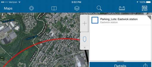
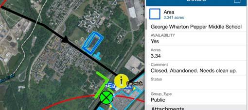
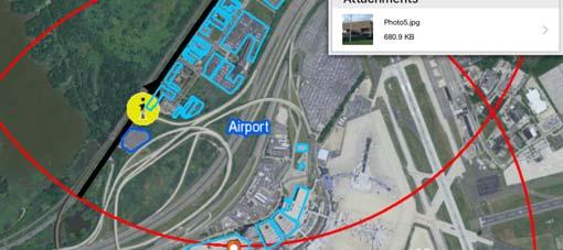
11 Field Data Collection Support Needs Needed to facilitate in the field Verification of station accessibility Identify parking lots in proximity to rail station Collect attributes of potential parking lots Identify potential passenger queuing areas Identify preliminary emergency aid station areas and entrance/egress paths Evaluate vehicle traffic flows around rail station Define initial traffic management plan elements Begin to determine pedestrian traffic flow and signage


12 Field Data Collection Support Solution Mobile Hardware Solution ipads Mobile Software Solution access published ArcGIS Online web maps through Esri Collector app


13 Field Data Collection Support Solution
14 Field Data Collection Lessons Learned 1. ArcGIS for Server 1. Need to have a public exposed domain to the internet 2. For easier data access; the map services credentials were saved within ArcGIS online 2. Syncing offline field work 1. Requires the Geodatabase Archiving option to be enabled 2. Features to have GlobalID for editing. 3. Large sized images 1. Did not often get loaded as attachment 2. Required to bring back to office to download and link

15 Papal Visit Story Map

16 Papal Visit Story Map

17 Papal Visit Story Map
18 Conclusion 1. Actual attendance numbers significantly lower than anticipated 2. ArcGIS Platform resulted in substantial time/cost savings for planning process 3. Team able to field staff, collect data, and conclude major planning efforts within 2 months 4. Team members remarked on ArcGIS Online and Collector app ease of use 5. SEPTA decided not to release web apps or story map to public 6. SEPTA developed their own CartoDB based web map for public communication
Collector for ArcGIS: An Overview
 Federal GIS Conference February 9 10, 2015 Washington, DC Collector for ArcGIS: An Overview Carrie Tropasso GIS Technical Lead, PA DCNR Mike Bialousz GIS Director, PA DCNR Matt Kennedy Solutions Engineer,
Deploying Mobile Solutions Agenda. Quick Overview on Strategy Walk thru of Mobile Apps Deploying Mobile Apps
 Deploying Mobile Solutions Agenda Quick Overview on Strategy Walk thru of Mobile Apps Deploying Mobile Apps ArcGIS Apps Making mapping and location aware apps available across your organization Knowledge
FHWA s Innovative New Traffic Noise Model Applications Ahmed El-Aassar, Ph.D., P.E. Kevin Switala, GISP
 FHWA s Innovative New Traffic Noise Model Applications Ahmed El-Aassar, Ph.D., P.E. Kevin Switala, GISP Presentation Outline Background Challenges Solution Overview Project Approach TNM 3.0 Capabilities
Best Practices for Utility Management. Presented by Steve Osiecki, GISP
 Best Practices for Utility Management Presented by Steve Osiecki, GISP Agenda Data management for utilities Developing harmonized CAD/GIS environment Importance of a good database structure Tools for implementation
MOBILE & WEB GIS. Improving Data Collection & Sharing
 MOBILE & WEB GIS Improving Data Collection & Sharing Suzanne M. Zitzman, GISP Maser Consulting P.A. Principal/Discipline Leader of GIS Asset Management Services Over 32 years experience in asset and facility
ArcGIS for Water Utilities
 ArcGIS for Water Utilities Mark Robbins Joe Morocco Agenda Introductions ArcGIS for Water Utilities Overview Demonstrations Getting Started with ArcGIS for Water Utilities Common Deployment Scenarios Discussion
Leveraging GIS-based Technology and Business Analytics to Support More Effective Asset Management
 Leveraging GIS-based Technology and Business Analytics to Support More Effective Asset Management November 2017 October 2017 Jayson Brennen, GISP Like it Or Not... We Are Now a Technology-Driven Society
ArcGIS Workflow Manager: Advanced Topics. Kevin Bedel & Nishi Mishra
 ArcGIS Workflow Manager: Advanced Topics Kevin Bedel & Nishi Mishra Session Topics Overview Configure & Design Notify & Relate Integrate & Analyze Overview What is ArcGIS Workflow Manager? Configure &
ArcGIS Workflow Manager: Advanced Workflows and Concepts. Kevin Bedel & Nishi Mishra
 ArcGIS Workflow Manager: Advanced Workflows and Concepts Kevin Bedel & Nishi Mishra Session Topics Overview Configure & Design Notify & Relationships Integrate & Geoprocess Overview ArcGIS Workflow Manager
ArcGIS Workflow Manager:
 ArcGIS Workflow Manager: Advanced Topics Kevin Bedel & Nishi Mishra Session Topics Overview Configure & Design Notify & Relate Integrate & Analyze Overview What is ArcGIS Workflow Manager? Configure &
Location-driven business at the
 Location-driven business at the Utah Department of Transportation Jeff Saunders Farallon Geographics, Inc. Senior Geodatabase Developer Dan Paske Utah Department of Transportation Oracle DBA Today s Goals
Open Data and Interagency Collaboration
 Open Data and Interagency Collaboration Interwest Consulting Group Steve Gay, GISP www.interwestgrp.com/gisblog Agencies Cosumnes Community Services District City of Elk Grove Sacramento County Sacramento
A Case Study from Phoenix Sky Harbor. April 29, 2009
 Implementing ArcGIS Server as a Hub within an Enterprise Architecture A Case Study from Phoenix Sky Harbor International Airport Dave Feuer Dave Feuer April 29, 2009 Objectives of Aviation Geospatial Technology
From data to display Data loading, quality control and workflow management
 From data to display Data loading, quality control and workflow management Kiyoshi Yamashita Kristen Waldvogel Esri Software Components Production Mapping Data Review Feature Manager Workflow Management
ArcGIS Workflow Manager An Introduction
 Esri International User Conference San Diego, California Technical Workshops July 24, 2012 ArcGIS Workflow Manager An Introduction Kevin Bedel Nishi Mishra Session Topics Introduction to ArcGIS Workflow
ArcGIS for Transportation. Tom Brenneman, Gary Waters
 ArcGIS for Transportation Tom Brenneman, Gary Waters ArcGIS for Transportation A product for Esri s transportation customers A series of useful maps and apps focused on transportation Organized into modules
Engaging the Crowd. Nick Land
 Engaging the Crowd Nick Land nland@esri.com GIS Is Getting Smarter Integrating and Leveraging Many Innovations IoT Smart Devices Advanced Analytics Smart Mapping Real-Time Faster Computing Web Services
Getting started with open data and ArcGIS Hub. Graham Hudgins, esri product engineer
 Getting started with open data and ArcGIS Hub Graham Hudgins, esri product engineer Agenda Overview of open data in the ArcGIS Hub Demonstration of open data capabilities Preparing your data - best practices
Best Practices for your ArcGIS Online Organization
 Best Practices for your ArcGIS Online Organization Bern Szukalski @bernszukalski Jeff Archer @vee_dubb Esri UC 2014 Technical Workshop Best Practices for your ArcGIS Organization Workshop Overview Not
Modernizing and Strengthening Pipeline GIS. Jeff Allen, Anjali Bhangay, Tom Coolidge and Vanessa Ramirez
 Modernizing and Strengthening Pipeline GIS Jeff Allen, Anjali Bhangay, Tom Coolidge and Vanessa Ramirez Agenda Overview of ArcGIS for Pipeline Demo System of Record UPDM and the Utility Network System
Utilizing Geospatial Resources for Regional Collaboration during UCI World Championships
 Utilizing Geospatial Resources for Regional Collaboration during UCI World Championships JUSTIN BRIGGS 911 GIS MANAGER RICHMOND DEPARTMENT OF EMERGENCY COMMUNICATIONS & JENNIFER MCKEE, GISP GIS ANALYST
ESRI ROADMAP FOR UTILITIES AND TELECOMMUNICATIONS COMPANIES
 ESRI ROADMAP FOR UTILITIES AND TELECOMMUNICATIONS COMPANIES Introduction Over the last several years, the ArcGIS has emerged as a true IT platform. According to Phil Simon, the author of the acclaimed
ArcGIS Workflow Manager Advanced Workflows and Concepts
 Esri International User Conference San Diego, California Technical Workshops July 26, 2012 ArcGIS Workflow Manager Advanced Workflows and Concepts Raghavendra Sunku Kevin Bedel Session Topics ArcGIS Workflow
GIS-T Symposium 2017 PennDOT s Maintenance-IQ: How Has It Been Used to Better Operations
 GIS-T Symposium 2017 PennDOT s Maintenance-IQ: How Has It Been Used to Better Operations Matthew Long, GIS and Transportation Planning Specialist PennDOT Office of Planning and Programming Nate Reck, Gov
ArcGIS Data Reviewer: An Introduction. Chandan Banerjee Jay Cary
 ArcGIS Data Reviewer: An Introduction Chandan Banerjee Jay Cary Workshop agenda Defining data quality What is ArcGIS Data Reviewer? Automated review Semi-automated review Managing errors Summary/resources
Taking Advantage of ArcGIS Online to Push a Mobile Agenda
 2013 Esri International User Conference July 8 12, 2013 San Diego, California Taking Advantage of ArcGIS Online to Push a Mobile Agenda Michael Olkin Town of Amherst, MA Esri UC2013. Some of our goals
ArcGIS for Emergency Management-
 ArcGIS for Emergency Management- Configuring the Solutions Jess Neuner Nikki Golding Agenda Introduction Solution Offering What s Next Your Feedback ArcGIS as a Platform Simple, Open, and Configurable
ArcGIS Data Reviewer: Integrating Data Quality Control into Web Applications. Shankar Chandrasekaran
 ArcGIS Data Reviewer: Integrating Data Quality Control into Web Applications Shankar Chandrasekaran Agenda What is ArcGIS Data Reviewer? Automated Review Semi-Automated Review Analyzing & Reporting Data
PHILADELPHIA OFFICE OF EMERGENCY MANAGEMENT SUPPORTING REAL-TIME EMERGENCY MANAGEMENT WITH THE ARCGIS PLATFORM
 PHILADELPHIA OFFICE OF EMERGENCY MANAGEMENT SUPPORTING REAL-TIME EMERGENCY MANAGEMENT WITH THE ARCGIS PLATFORM Brian Wells Philadelphia OEM Andrew Smart geographit GIS in Emergency Management - Key Considerations
ArcGIS for Gas Utilities: An Overview
 ArcGIS for Gas Utilities: An Overview Tom Coolidge Pat Dolan Mike Miller Esri UC 2014 Technical Workshop Agenda Introduction to ArcGIS for Gas Utilities Demonstration Deployment Approach Configuration
North Jersey Transportation Planning Authority (NJTPA) Asset Management Data Model 2015 IHEEP CONFERENCE Pittsburg, PA September 15, 2015
 Asset Management Data Model 2015 IHEEP CONFERENCE Pittsburg, PA September 15, 2015") North Jersey Transportation Planning Authority (NJTPA) Asset Management Data Model 2015 IHEEP CONFERENCE Pittsburg, PA September 15, 2015 NJTPA Asset Management Data Model Gabrielle Fausel (NJTPA) Presenters
North Jersey Transportation Planning Authority (NJTPA) Asset Management Data Model 2015 IHEEP CONFERENCE Pittsburg, PA September 15, 2015 NJTPA Asset Management Data Model Gabrielle Fausel (NJTPA) Presenters
ArcGIS Workflow Manager: Effectively Managing Workflows within the ArcGIS Enterprise
 ArcGIS Workflow Manager: Effectively Managing Workflows within the ArcGIS Enterprise Elizabeth Wilcox and Bryan Piersol Guest Presenter: Ronnie Buzzard, United States Army Geospatial Center Our plan today
Emerging Patterns for Implementing the ArcGIS Platform. Marten Hogeweg Peter Bottenberg
 Emerging Patterns for Implementing the ArcGIS Platform Marten Hogeweg Peter Bottenberg Deploying the Platform is About It s About the Organization Enabling All of the Users in the Organization Bringing
BlackBerry Offerings for Desktop Windows 10 and macos
 BlackBerry Offerings for Desktop Windows 10 and macos Enable secure remote connectivity from any computer. Securely browse intranets and web apps. Email, calendar, contacts, files including offline availability.
Implementing ArcGIS Solutions. Michael Beavers
 Implementing ArcGIS Solutions Michael Beavers mbeavers@esri.com ArcGIS as a Platform Simple, Open, and Configurable Knowledge Workers Executive Access Public Engagement Work Anywhere Enterprise Integration
Managing Gas Facility Inspections with Workforce for ArcGIS. Esri GeoConX 2017
 Managing Gas Facility Inspections with Workforce for ArcGIS Esri GeoConX 2017 Peoples Gas Founded in 1850 Deliver natural gas to about 843,000 customers in the city of Chicago. ~20 GIS staff supporting
ArcGIS Data Reviewer: An Introduction. Chandan Banerjee Jay Cary
 ArcGIS Data Reviewer: An Introduction Chandan Banerjee Jay Cary Workshop agenda Importance of data quality What is ArcGIS Data Reviewer? Automated review Semi-automated review Managing errors and data
Esri Defense Mapping:
 Esri Defense Mapping: Enterprise Production Management GREG WAITE & G.C. RICE Esri Defense Mapping EXTENSION TO ARCGIS Esri Defense Mapping Produce, Manage, and Share Authoritative Content System of Engagement
ESRI ArcGIS Mobile Integration with Work Asset Management
 ESRI ArcGIS Mobile Integration with Work Asset Management Sivashankar Dharmaraj 1, Reevu Mukherjee 2 1 Senior Associate Consultant, Infosys Limited 2 Associate Business Analyst, Infosys Limited Plot No:
Get a Second Opinion: Enterprise GIS Health Checks. Matt Marino, Esri Sam Libby, Esri
 Get a Second Opinion: Enterprise GIS Health Checks Matt Marino, Esri Sam Libby, Esri What is an Enterprise GIS Health Check An Onsite Engagement Focusing On: - Proactively reviewing and assessing current
Increasing Community Resilience
 Increasing Community Resilience Planning, Mitigation & the Role of GIS Ryan Lanclos Emergency Management Industry Manager Esri Responsible for helping our communities: Mitigate Risk Reduce Impact Recover
Using Geospatial Technology to Support Stormwater Management and NPDES Compliance
 Using Geospatial Technology to Support Stormwater Management and NPDES Compliance Jayson Brennen CDM Smith September 2015 We are in the Middle of a Technology Explosion Hardware and Software Evolving Rapidly.
Get Up and Running with Insights for ArcGIS. Andrew Whitman Aravind Sivasailam
 Get Up and Running with Insights for ArcGIS Andrew Whitman Aravind Sivasailam Agenda What is Insights for ArcGIS? Explore Insights for ArcGIS How does Insights for ArcGIS work? Best Practices when using
ArcGIS Network Analyst: Network Analysis with ArcGIS Online and On- Premises Services
 ArcGIS Network Analyst: Network Analysis with ArcGIS Online and On- Premises Services Deelesh Mandloi Dmitry Kudinov Esri UC 2014 Technical Workshop Introductions Who are we? - Network Analyst Product
ArcGIS for Water Utilities: An Introduction
 Esri International User Conference San Diego, California Technical Workshops July 26, 2012 ArcGIS for Water Utilities: An Introduction Howard Crothers Mike Miller Agenda Introduction ArcGIS for Water Utilities
EXECUTIVE SUMMARY / BRIEF OVERVIEW
 EXECUTIVE SUMMARY / BRIEF OVERVIEW Roanoke County s Public Safety departments desired an application to replace a paper map-focused incident command system to one which could be easily deployed from any
ArcGIS for State and Local Government: An Overview. Nikki Golding Scott Oppmann
 ArcGIS for State and Local Government: An Overview Nikki Golding Scott Oppmann Agenda Introduction Why are we doing this? What are we doing to help? ArcGIS as a Platform Knowledge Workers Executive Access
ArcGIS Extensions: Tool for Improving Data and Map Production. Joseph Sheffield & Sherry Fagin
 ArcGIS Extensions: Tool for Improving Data and Map Production Joseph Sheffield & Sherry Fagin Workshop Roadmap Improving Data and Map Production Why Standards? Managing production work Importance of data
Smart Installations. Ben Conklin Jim Bauer
 Smart Installations Ben Conklin Jim Bauer Smart Installations Responding to challenges and leveraging advances in technology A Smart Installation improves operational readiness by providing shared understanding
Interactive Transit Information and Decision Support System. The Connected Vehicle Technology Challenge
 Interactive Transit Information and Decision Support System The Connected Vehicle Technology Challenge Team Member: Xiaosi Zeng Graduate Student Zachry Department of Civil Engineering Texas A&M University
FK Distribution. High Density Postal Routing with ArcGIS
 FK Distribution High Density Postal Routing with ArcGIS About Rapidis Software and tools for Transportation and Logistics Esri Business Partner since 2003 All products and solutions are based on ArcGIS
Large Scale Field Data Collection and Open Source GIS
 Large Scale Field Data Collection and Open Source GIS Spatially Integrated Software Matt von Wahlde Mobile Data Collection and GIS What s Covered System for collecting transit system accessibility data
Mobility: Deploy Your Enterprise GIS to the Field. Chang Chee Leong
 Mobility: Deploy Your Enterprise GIS to the Field Chang Chee Leong What is GIS Mobility? Extends the reach of Enterprise GIS from the office to the field using Mobile Devices and Apps Bring your maps to
Esri Enterprise Advantage Program (EEAP) Defining and Driving Platform Vision. Patrick Mahoney, USDOI BLM Christie Pleiss, Esri Mark Williams, Esri
 Defining and Driving Platform Vision. Patrick Mahoney, USDOI BLM Christie Pleiss, Esri Mark Williams, Esri") Esri Enterprise Advantage Program (EEAP) Defining and Driving Platform Vision Patrick Mahoney, USDOI BLM Christie Pleiss, Esri Mark Williams, Esri Software Content People Esri Services Ready to help you
Esri Enterprise Advantage Program (EEAP) Defining and Driving Platform Vision Patrick Mahoney, USDOI BLM Christie Pleiss, Esri Mark Williams, Esri Software Content People Esri Services Ready to help you
System Implementation. James Tedrick, Esri
 System Implementation James Tedrick, Esri Deploying the Platform is About It s About the Organization Enabling All of the Users in the Organization Bringing the Right Technology to the Mission Unlocking
POWER PORTFOLIO PRODUCT BROCHURE
 POWER PORTFOLIO PRODUCT BROCHURE 2 Power Portfolio Change is constant and its impacts can affect you personally. Whether man-made or naturally occurring, our changing landscape influences your plans and
PRODUCT BROCHURE POWER PORTFOLIO
 PRODUCT BROCHURE POWER PORTFOLIO 2 Power Portfolio Change is constant and its impacts can affect you personally. Whether man-made or naturally occurring, our changing landscape influences your plans and
ArcGIS for Emergency Management. Walter Potts Jeff Baranyi Nikki Golding
 ArcGIS for Emergency Management Walter Potts Jeff Baranyi Nikki Golding Agenda Introduction Solution Offering What s Next? Your Feedback A common experience. Hurricane Sandy 2004 2005 Southeast Tornadoes
Using ArcGIS Solutions to Identify Water Leaks. Michael Miller
 Using ArcGIS Solutions to Identify Water Leaks Michael Miller ArcGIS Solutions Overview ArcGIS Includes 400+ Industry Specific Configurations Organized by 9 Primary Domains ArcGIS Solutions A core part
World Bank Transport Forum Learning Session Leveraging ICT to Support Transport Development. OpenPlans/OpenGeo. March 30, 2011
 World Bank Transport Forum Learning Session Leveraging ICT to Support Transport Development OpenPlans/OpenGeo March 30, 2011 OpenGeo & OpenPlans OpenPlans Non-profit technology organization Focus on civic
Esri Roads and Highways An Introduction. Nathan Easley Rahul Rakshit
 Esri Roads and Highways An Introduction Nathan Easley Rahul Rakshit Roads and Highways Linear Referencing for the Transportation Enterprise GIS-enabled LRS platform LRS management LRS editing & maintenance
SHARED SERVICES CAPITAL - INFORMATION TECHNOLOGY
 Updated: August, 0 Page of SHARED SERVICES CAPITAL - INFORMATION TECHNOLOGY 0.0 OVERVIEW Information Technology ( IT ) refers to computer systems (hardware, software and applications) that support business
12th UNGIWG Plenary Meeting ArcGIS for UNGIWG and UNSDI
 12th UNGIWG Plenary Meeting ArcGIS for UNGIWG and UNSDI ssawaya@esri.com / @salim_sawaya Many people want your authoritative knowledge Co-workers Executives & decision makers Customers Citizens Co-workers
Implementing ArcGIS Solutions NIKKI GOLDING SCOTT OPPMANN
 Implementing ArcGIS Solutions NIKKI GOLDING SCOTT OPPMANN Agenda (Update) Introduction Implementation Patterns Opioid Epidemic Solution Configuration Approaches Your Feedback ArcGIS as a Platform Simple,
Mobile Incident Command Center. Darren Jones, GISP GIS Analyst I Roanoke County, VA
 Mobile Incident Command Center Darren Jones, GISP GIS Analyst I Roanoke County, VA Mobile Incident Command Center Initiation Time and costs Design Philosophy Applications ArcGIS Online Updates What happens
ArcGIS Mobile Deployment for Orange County Sheriff s Office
 ArcGIS Mobile Deployment for Orange County Sheriff s Office Bergmann Associates Jeffrey Volpe, GISP GIS Business Segment Leader 8653 Baypine Road, Suite 100 Jacksonville, Florida 32256 (904) 363-3133 Ext.
ArcGIS for the Military: Sustainment and Logistics
 ArcGIS for the Military: Sustainment and Logistics Joe Bayles Anneley McMillan Jim Weakland Esri UC 2014 Technical Workshop Goals of the Workshop Briefly review ArcGIS for the Military system Explain how
ArcGIS for the Military Land Operations
 2013 Esri International User Conference July 8 12, 2013 San Diego, California Technical Workshop ArcGIS for the Military Land Simon Warwick, Scott Cecilio Esri UC2013. Technical Workshop. GIS Is About
Web GIS: An Introduction. Shannon Kalisky Kelly Gerrow-Wilcox
 Web GIS: An Introduction Shannon Kalisky Kelly Gerrow-Wilcox When we talk about Web GIS we are talking about an end-to-end experience not just a REST service. ArcGIS Enterprise ArcGIS Online Web GIS with
Esri Technical Roadmap. Chris Hansen
 Esri Technical Roadmap Chris Hansen Platform Capabilities Mapping Smart Mapping Vector Tiles Mapping Temporal Patterns Charting Mobile Map Packages 3D Earth Urban and Landscape Models - 3D Object Layers
Pauline Kent Enterprise Spatial Services Portfolio Manager Information Services. Mapshare Migration The Journey
 Pauline Kent Enterprise Spatial Services Portfolio Manager Information Services Mapshare Migration The Journey Drivers 2 Drivers 12 legacy (officially Zombie status) web mapping sites 3 Drivers 12 legacy
The Power of Spatially Enabling Your Real-time Facilities Data. Copyright 2015 OSIsoft, LLC
 The Power of Spatially Enabling Your Real-time Facilities Data Presented by James Sullivan Recommended Flow of Topics in Agenda Business Challenge About GIS ArcGIS Platform and the PI System Create and
ArcGIS for Emergency Management: An Overview
 2013 Esri International User Conference July 8 12, 2013 San Diego, California Technical Workshop ArcGIS for Emergency Management: An Overview Jeff Baranyi Lindsay Thomas Esri UC2013. Technical Workshop.
Automated Fare Collection 2.0
 Automated Fare Collection 2.0 Next Generation MBTA Fare System Legislative Briefing August 14, 2018 Overview THE MBTA SEEKS BROAD PUBLIC INPUT ON THE UPCOMING UPDATE OF ITS FARE COLLECTION SYSTEM. INPUT
Presented by John Hudler Geospatial Group Leader Office of Transportation Data Georgia Department of Transportation
 Presented by John Hudler Geospatial Group Leader Office of Transportation Data Georgia Department of Transportation Collection, Quality Assurance and Reporting of the States roadway and transportation
Fiscal Management and Control Board Briefing APRIL 30, 2018
 Fiscal Management and Control Board Briefing APRIL 30, 2018 Purpose of the Presentation Solicit FMCB feedback on: - Current assumptions guiding the Rail Vision - Purpose of MBTA Rail Service - Current
REQUEST FOR PROPOSALS
 Announcement REQUEST FOR PROPOSALS ESRI GIS Implementation Services The Madison Metropolitan Sewerage District (MMSD or district ) seeks proposals from qualified vendors to implement Esri s geographic
Creative Ways to better Manage your Infrastructure, new and emerging Technology. Karen Stewart Esri Canada
 Creative Ways to better Manage your Infrastructure, new and emerging Technology Karen Stewart Esri Canada Traffic camera Electric wiring Information portal Road signage Viaduct Traffic sign Canal Fleet
The Manager s Guide to Strategic Workforce Development. Charles Jones Paul Holcombe
 The Manager s Guide to Strategic Workforce Development Charles Jones Paul Holcombe Agenda Importance of Workforce Development Planning Workforce Development Planning Process How Esri Educational Services
ArcGIS Workflow Manager: An Introduction
 ArcGIS Workflow Manager: An Introduction Tope Bello and Michael Broadbent Esri UC 2014 Technical Workshop Why are you here? Importance of standardizing GIS and non-gis workflows ArcGIS Workflow Manager
Services Guide April The following is a description of the services offered by PriorIT Consulting, LLC.
 SERVICES OFFERED The following is a description of the services offered by PriorIT Consulting, LLC. Service Descriptions: Strategic Planning: An enterprise GIS implementation involves a considerable amount
What s New in ArcGIS Enterprise Bill Major Craig Cleveland
 What s New in ArcGIS Enterprise Bill Major Craig Cleveland Agenda Overview of ArcGIS Enterprise New in administration New in publishing New in analysis Overview ArcGIS Enterprise is a full-featured mapping,
ArcGIS Extensions: Tools for Improving Data and Map Production. Sherry Fagin & Amber Bethell
 ArcGIS Extensions: Tools for Improving Data and Map Production Sherry Fagin & Amber Bethell Production Assembly Line Production Produce a flashy sports car Without Standards Production Produce a flashy
Campus Enterprise GIS
 Campus Enterprise GIS Cross Platform Supported: Enterprise GIS Initiative: Webmapping Making the Case for Enterprise GIS at UMD Esri Resources Available to UMD Webmapping for Information Access Demonstration:
ArcGIS for Land Records
 Virginia Association of Assessing Officers 63 rd Annual Conference October, 2011 ArcGIS for Land Records Arthur Robinson, Solution Engineer Bob Rike, Account Executive ArcGIS is a System A Complete System
Enterprise Technology And Solutions by ESRI. Dave Wrazien Solution Architect ESRI, Inc.
 Enterprise Technology And Solutions by ESRI Dave Wrazien Solution Architect ESRI, Inc. What is Enterprise? An enterprise consists of all functional departments, people, and systems within an organization.
SOUTHEASTERN PENNSYLVANIA TRANSPORTATION AUTHORITY
 SOUTHEASTERN PENNSYLVANIA TRANSPORTATION AUTHORITY Ryers Station Improvement Project Robert L. Lund, Jr., PE Assistant General Manager Engineering, Maintenance and Construction Division David J. Sands,
Integrating Analytic Talent for Intelligence Analysis. David Attaway John Fry
 Integrating Analytic Talent for Intelligence Analysis David Attaway John Fry Location, Mapping and GIS Are Becoming Essential A Fundamental Language for Understanding and Managing Our World Providing
Intergraph Mobile GeoSpatial Products. Bradley Skelton
 Intergraph Mobile GeoSpatial Products Bradley Skelton The Mobile Revolution Everyone has a mobile or tablet device People always have their mobile device with them Mobile market growing exponentially People
ArcGIS for Emergency Management 1:00 2:15pm
 Esri Southwest User Conference September 17-19, 2012 Denver, Colorado ArcGIS for Emergency Management 1:00 2:15pm Jeff Baranyi jbaranyi@esri.com @GISPublicSafety 303-449-7779 Agenda Overview of ArcGIS
Enterprise Access to Traffic Information. Michael Bish Matt Hiland Tony Pietropola
 Enterprise Access to Traffic Information Michael Bish Matt Hiland Tony Pietropola Traffic Information Access (TRINA) Background Project Objectives Approach Outcome TRINA Background Traffic information
Esri Production Mapping An Introduction
 2013 Esri International User Conference July 8 12, 2013 San Diego, California Technical Workshop Esri Production Mapping An Introduction Amber Bethell Sean Granata Esri UC2013. Technical Workshop. Workshop
LOCATION PLATFORM for Utilities
 LOCATION PLATFORM for Utilities How Mapping and GIS are Transforming Utilities Clifford Okembo We are a professional Geospatial solutions company who inspires, educates and enables our customers with working
City of Elk Grove Evolving the use of GIS
 City of Elk Grove Evolving the use of GIS Interwest GIS Steve Gay, GISP Jason Latoski www.interwestgrp.com/gisblog Interwest Consulting Group Provides GIS and IT Services to local governments Contracted
GIS Lighting Up The Enterprise
 Marketing Operations Field Workers IT Professionals Executives Project Management Citizen Engagement Mobile GIS Lighting Up The Enterprise Conference Theme - GIS Lighting Up the Enterprise Lighting up
Reporting System of Secretariat
 Reporting System of Secretariat Borislav Brunet Provincial Secretariat for Agriculture, Water Management and Forestry About Provincial Secretariat for Agriculture, Water Management and Forestry (PSAWF)
Digital Transformation and Operational Intelligence in Utilities. Agendra Kumar President, Esri India
 Digital Transformation and Operational Intelligence in Utilities Agendra Kumar President, Esri India Agenda Market Observations and Trends Role of GIS Vision and Road Map for Smart Utilities Summary and
The Importance of Data Quality Within Your Organization. Sherry Fagin and Andy Ommen
 The Importance of Data Quality Within Your Organization Sherry Fagin and Andy Ommen Workshop Agenda Perspectives of Data Quality What is ArcGIS Data Reviewer? Quality Control Processes Reporting Data Quality
What is new with the ArcFM Solution
 What is new with the ArcFM Solution Telvent Utilities Has Become 2 ArcFM 10.2 Release Plan What is included in 10.2 Core ArcFM Feeder Manager 2.0 (FM 2.0), including support for large datasets All new
GIS Technology After Redistricting. Richard Leadbeater, Esri Global Manager August 8, 2012
 GIS Technology After Redistricting Richard Leadbeater, Esri Global Manager August 8, 2012 Redistricting Online Increasing the collaboration between government and citizens Review Connect Public Web Mashups