AUTOMATED PAVEMENT CONDITION SURVEY FIELD MANUAL PUBLICATION 336 APRIL 2017 PUB 336 (4-17)
|
|
|
- Marcus Jenkins
- 6 years ago
- Views:
Transcription
1 AUTOMATED PAVEMENT CONDITION SURVEY FIELD MANUAL PUBLICATION 336 APRIL 2017 PREPARED BY: BUREAU OF MAINTENANCE AND OPERATIONS ASSET MANAGEMENT DIVISION P.O. Box 3437 HARRISBURG, PENNSYLVANIA (717) PUB 336 (4-17)
2
3 COMMONWEALTH OF PENNSYLVANIA DEPARTMENT OF TRANSPORTATION AUTOMATED PAVEMENT CONDITION SURVEY FIELD MANUAL APRIL 2017 PUBLICATION 336
4
5 TABLE OF CONTENTS INTRODUCTION... 1 PENNSYLVANIA LOCATION REFERENCE SYSTEM... 1 SURVEY TECHNIQUE AND PROCEDURES DEFINITIONS GENERAL: WHEEL PATH LOCATIONS: EDGE OF PAVEMENT: LANE WIDTH: CONDITION IDENTIFICATION GUIDE PROFILE DATA COLLECTION AND PROCESSING RUT DEPTH BITUMINOUS SURFACE PAVEMENTS Fatigue Cracking Description Transverse Cracking Miscellaneous Cracking Edge Deterioration Bituminous Patching Raveling / Weathering Left Edge Joint RIGID PAVEMENTS Faulted Joints Broken Slab Transverse Joint Spalling Transverse Cracking Longitudinal Cracking Longitudinal Joint Spalling Bituminous Patching Portland Cement Concrete Patching... 70
6
7 Introduction This manual is for use with the Pennsylvania Department of Transportation's Pavement Condition Survey. The Pavement Condition Survey is a distress survey, with the purpose of providing quantified, location-specific condition data on Pennsylvania's network of about 40,000 centerline miles of state highways. The data collected is used for the following purposes: 1. To provide a uniform statewide condition evaluation that would improve decision making. 2. To provide management with the information and tools to monitor condition of the network, assess future needs, establish county condition rankings and optimize investments. 3. To provide condition information to fulfill the requirements of Act 68 (1980) which requires the allocating of maintenance funds to the individual counties based on needs. 4. To provide information for monitoring the performance of various pavement designs, rehabilitation and maintenance techniques. 5. To provide information for identifying candidate projects for maintenance and betterment programs. Pennsylvania Location Reference System Introduction: The Location Reference System (LRS) is designed to bring Pennsylvania s roadway designations into a verifiable, flexible, and constant Engineering standard. It is the key to the collection, storage, and integration of roadway information within the Department. CO/SR/SEG/OFFSET is the KEY series of numbers given to the location of a point or feature on a state route. This fourteen digit number (CO/SR/SEG/OFFSET) is an integral part of the computerized Roadway Management System (RMS) where key roadway data are stored. Pennsylvania is divided into 67 counties. Each county (CO) has a number which represents the first two digits of the LRS number. In each county there are state routes. The State Route (SR) is subdivided into approximate one-half mile segments (SEG). Finally, the OFFSET is an even smaller subdivision of the segment. The offset is the distance to a particular roadway feature from the beginning of the segment. 1
8 The Location Reference System is not complicated and anyone can easily take advantage of the benefits it has to offer. It adds permanence, accuracy, and stability to our marker system. It is easy to understand, costs less to maintain, and generates a computerized representation of the state highway network. The following material will provide some insight into how the LRS was developed and the type of information that can be inferred utilizing the 14 digit KEY. County (CO): A. County Names, Numbers, and Maintenance District No.: County Name Adams Allegheny Armstrong Beaver Bedford Berks Blair Bradford Bucks Butler Cambria Cameron Carbon Centre Chester Clarion Clearfield Clinton Columbia Crawford Cumberland Dauphin Delaware Elk Erie Fayette Forest Franklin Fulton Greene Huntingdon County No. (CO) Maint. Dist. No
9 3 County Name Indiana Jefferson Juniata Lackawanna Lancaster Lawrence Lebanon Lehigh Luzerne Lycoming McKean Mercer Mifflin Monroe Montgomery Montour Northampton Northumberland Perry Pike Potter Schuylkill Snyder Somerset Sullivan Susquehanna Tioga Union Venango Warren Washington Wayne Westmoreland Wyoming York Philadelphia County No. (CO) Maint. Dist. No
10 State Routes (SR): A. SR Numbering Convention: SR Value 1. Interstates, US Routes, and PA Routes Quadrant Routes Note: By quadrants 1, 2, 3, or 4 QUADRANTS 4 1 TR 400 SR US 73 SR Relocated Traffic Routes
11 4. Interchanges INTERCHANGE SR assignment according to a predominant main line SR. SR SR SR SR WYEs Rest Areas Truck Escape Ramps Others B. Odd/Even Convention: 1. Odd numbered SRs are assigned to north/south direction. 2. Even numbered SRs are assigned to east/west direction. 3. The Odd/Even convention MAY NOT apply to PA or US traffic routes. 5
12 C. Traffic Routes - Routes which have been assigned an Interstate, U.S., or PA traffic route designation. D. Quadrant Routes (Non-traffic routes) 1. Four Quadrants - refer to quadrant diagram - refer to SR numbering convention 2. Directional Convention: - Odd number State Routes are N/S direction - Even number State Routes are E/W direction E. Hierarchy - If 2 or more traffic routes occupy the same section of roadway, the following hierarchy applies. 1. Interstate 2. U.S. Routes 3. PA Routes 4. Quadrant Routes If the traffic routes are the same hierarchy class, then the SR number is assigned the lower numbered traffic route. US 322 SR 0322 SR DESIGNATION OF SHARED ROADWAY US 22/322 US 22 SR 0022 SR
13 Segments (SEG) A. Segment = approximately one-half mile sections of SR's that are usually numbered by 10's. B. The beginning and ending points of Segments are placed at physical features where possible. C. Direction Divided roads have directional segments North or East are even numbers South or West are odd numbers DIRECTIONAL SEGMENTING ON DIVIDED HIGHWAYS S/W Offset 2640 Offset 0000 INCREASING OFFSETS Approx. ½ mile Typical INCREASING OFFSETS N/E Offset
14 D. Interstate Interstate Segmenting is associated with the milepost. SEGMENTING ON INTERSTATE HIGHWAYS S/W SIGN 1551 Offset 2640 Offset 0000 INCREASING OFFSETS ½ mile ½ mile ½ mile ½ mile INCREASING OFFSETS N/E Offset MP MP MP
15 E. Common Interchange Configurations and Segmentation SB NB Predominant SR SEGMENT 0510 SR A DIR = B SEGMENT 0500 SR B SEGMENT 0750 SEGMENT 0760 SEGMENT 0260 SEGMENT 0020 SEGMENT 0250 SEGMENT 0010 DIAMOND INTERCHANGE SEGMENT 0510 SB NB SR B Predominant SR SEGMENT 0750 SEGMENT 0500 SEGMENT 0760 WB SR A EB SEGMENT 0250 SEGMENT 0010 SEGMENT 0260 SEGMENT 0020 CLOVER LEAF 9
16 F Series Segments: Turnbacks Abandonment Nulls SR 2013 Null Segment for SR 2013 SR 0016 TR 16 NULL SEGMENTS SR 0016 SR 2013 SR 0016 TR 16 G. Segment Numbering of Traffic Routes at County Boundaries: SR SEGMENT NUMBERING 0020 COUNTY A COUNTY B SR 0015 SR
17 H. Signs Identifiable in field, easy for identification of maintenance/work areas on the State Highway System. 1. Segment Marker - indicates SR and segment number at the beginning and end of each segment. If the beginning or end of a segment occurs at a physical feature, then the point of reference is at the physical feature and NOT the sign. 2. Intersection - indicates segmentation at the intersection of 2 or more state owned highways. Segment Marker at an Intersection 18 Segment Marker along the route 10 SR SR
18 3. SR/Segment Sign Placement SAMPLE STATE ROUTE SIGNING SR End Seg. SR Begin Seg SR End Seg. SR Begin Seg. 30 SR 1002 SR End Seg. & Begin Seg. 20 SR End Seg. SR Begin Seg. 10 Begin Seg. SR SR End Seg. 12
19 Offset (Offset) Distance in linear feet from the beginning of a segment to a point of interest measured in the INCREASING segment direction. Segment / Offset 10 / / /
20 Survey Technique And Procedures General: Many instances will be encountered in the performance of the Pavement Condition Survey which do not exactly conform to the general descriptions and instructions in this manual. Some of these are listed below, along with recommended procedures for evaluating. For other unusual circumstances, good judgment should be exercised and notes added to the data file. Multi-lane Roadways: All roadway segments will be evaluated in one pass. Because the lane being surveyed will represent the entire roadway width, best judgment must be used to select which lane to survey. For purposes of pavement maintenance the surveyor should select the lane exhibiting the most distresses. In most cases this will be the right lane on multi-lane roadways. Ramps: At this time, no separate evaluation will be made of ramps, as any maintenance and rehabilitation of ramps will usually be performed in conjunction with work on the main line. Ramp acceleration and deceleration lanes will be ignored when evaluating the main line pavement and shoulders. Do not survey acceleration or deceleration lanes, but collect information up to where the shoulder continues on the other side of the ramp (gore area). Bridges: Pavement condition data will not be reported for the bridge portion of a segment. The bridge length, determined by the limits of the bridge superstructure, will be excluded from the length of pavement being evaluated when determining lengths of extents. Bridge approach slabs are included in the pavement condition evaluation. No pavement condition data will be reported for segments with bridges 50% of the segment length or greater. All bridges will be included in roughness measurements. Brick or block pavement: Brick or block surfaces are rated as Flexible Surface Pavements. Only collect roughness and bituminous patching. 14
21 Definitions General: The following terms used in this manual are defined as follows: Pavement: The portion of the roadway intended for regular vehicular traffic. Bituminous Surface Pavement: A pavement with a bituminous riding surface on any type of base. Rigid Pavement: A pavement with a Portland Cement Concrete riding surface. Rigid pavement includes Plain Cement Concrete Pavement (PCCP) or Reinforced Cement Concrete Pavement (RCCP). (70 series pavements) Wheel Path Locations: To properly locate where various distress measurements are made, the following descriptions of spacing between wheel paths, offset from pavement edge and locations and widths of various parts of the pavement surface are defined. It is very difficult to operate pavement data collection equipment on all pavements under all conditions and meet the definitions. In these instances, the judgment of the operator/driver concerning the safe operation of the vehicle and the safety of the traveling public takes precedence over data collection. Distance Between Wheel Paths: For the purposes of profile data collection the centerline distance between the outside and inside wheel paths and the sensors mounted to collect data shall be 69 inches. Width of Outside Wheel Path: The outside wheel path shall be 30 inches wide with the center of the wheel path referenced along the same centerline location as the sensor mounted for the outside wheel path profile measurement. Width of Inside Wheel Path: The theoretical maximum inside wheel path width shall be 30 inches. There may be some instances on very narrow, secondary pavements where the inside wheel path must be less than 30 inches due to operational constraints. Width of Lane Center: The width of the center of the travel lane shall be 39 inches. The right most edge of the area bounding the lane center shall be immediately adjacent to the left most side of the area that is bounded by the outside wheel path. 15
22 Location of the Center of Outside Wheel Path on the Lane: The center of the outside wheel path is nominally located at the following distances from the right pavement edge for the following lane widths. The center of the outside wheel path located as described below allow for edge deterioration coverage on Pennsylvania's many narrow, secondary roads. Width Distance from Edge to Centerline of Outside Wheel Path Distance from Edge to Centerline of Inside Wheel Path 9.0 feet 26 inches 7.9 feet (95 inches) 10.0 feet 26 inches 7.9 feet (95 inches) 11.0 feet 31 inches 8.3 feet (100 inches) 12.0 feet 37 inches 8.8 feet (106 inches) It is often difficult for the driver to follow perfectly in the wheel paths as defined above and it is not expected that the vehicle will always be able to collect data exactly as shown. It is the intention of the above descriptions to: 1) Define where the sensors, outside wheel path, and pavement center are located with respect to the vehicle, and 2) Provide guidance to the vehicle operator concerning the appropriate location for operating the vehicle the majority of the time. Vehicle Operation in the Outside Wheel Path: Vehicle operation to be operated in the wheel path where the majority of the traffic routinely drives. The wheel path is often easily recognized as a discoloration or contrasting color of the pavement surface. The vehicle operator is expected to drive the vehicle with the right wheel path sensors in the middle of the apparent right wheel path used by vehicles. This will ensure that the profile, rut depth, faulting, and high resolution cameras are collecting information where the majority of the traffic is driving on the lane. Edge of Pavement: The pavement edge has various definitions depending upon the pavement type and functional classification. For the purpose of this specification the following pavement edge definitions apply. Bituminous pavements - unpaved shoulder: The pavement edge is defined as the rightmost transverse location where the bituminous paved surface ends and the unpaved surface of the shoulder begins. There may or may not be a paint lane stripe along these pavement types. 16
23 Bituminous pavements - paved shoulder: The pavement edge is defined as the side construction joint formed between the bituminous paved surface and the bituminous paved surface of the shoulder. In those locations where there is no construction joint or it cannot be readily identified, the pavement edge shall be the outside edge of the outside lane stripe. Jointed concrete pavements - bituminous shoulder: The pavement edge is defined as the construction joint formed by the portland cement concrete slab and the bituminous paved shoulder. Jointed concrete pavements - concrete shoulder: The pavement edge is defined as the rightmost construction joint between the travel lane and the shoulder. Note: These definitions assume that the data collection vehicle will be operated in the outside lane on multi-lane roads. In those situations where the vehicle operates in a lane other than the outside lane, the construction joint shall be used to identify the right side of the lane. If a construction joint cannot be readily identified then the right side pavement lane stripe shall be used. These definitions are expected to apply on most conditions found in Pennsylvania. In those situations where the definitions do not apply, PENNDOT will define the pavement edge. Lane Width: The lane width will have various definitions depending upon the paving material. Bituminous pavements: The lane width is defined as the transverse distance from the right side pavement edge to the left construction joint. If the construction joint is not readily discernible, the left side of the lane shall be defined by the lane paint stripe. Collect and report bituminous distresses according to the placement on the lane as detailed in the Condition Identification section of this manual. All bituminous distresses are to be evaluated on every segment, on a segment by segment basis. Jointed Concrete Pavements: The lane width is defined as the transverse distance from the right side of the pavement edge to the left construction joint forming the slab. In those situations where the construction joint is not readily discernible, the left pavement edge shall be defined by the lane stripe. Jointed concrete pavements require additional definitions to define the location of joint and slab related conditions. Joints: Joints are straight transverse or longitudinal discontinuities in the pavement surface caused by original construction or maintenance activities. A transverse joint should only be counted and evaluated if it is an original construction joint or a joint caused by a full width concrete pavement patch. Longitudinal joints should only be evaluated if it is the result of original construction or concrete patches that are large enough to be included in the patch area rating definitions in the Condition Identification Section of this manual. There will be a few cases where the longitudinal joint falls within the lane. In this case, count and rate both slabs created by the longitudinal joint. 17
24 Joint area for evaluation: The procedure for identifying joint conditions is: Identify the joint. Evaluate the pavement for the full lane width on either side of the joint for 1.0 ft each side of the joint. Assign the joint condition to the appropriate classification and severity rating. Collect and report all distress on a joint (the distresses are cumulative). Slab Conditions: Slab interior from 1.0 ft of joint area as defined above to the next 1.0 ft area of the next joint. Collect and report all distress on a slab (the distresses are cumulative) with the exception of Broken Slab. Rating a slab as Broken supersedes all other slab distresses. JOINT AREA SLAB 18
25 CONDITION IDENTIFICATION GUIDE 19
26 Profile Data Collection and Processing Description: Roughness on a traveled surface is the deviations of a surface from a true planar surface with characteristic dimensions that affect vehicle dynamics and ride quality (ASTM E950). It will be estimated by IRI which is calculated from longitudinal profile measurements. A longitudinal profile is the perpendicular deviations of the pavement surface from an established reference parallel to the lane direction. Measurement: Longitudinal profile is measured at least every 6.0 inches in the designated data collection lane for both the outside and inside wheel paths located 69 inches apart. Computation: The International Roughness Index (IRI) is used to indicate the amount of roughness. IRI is an index computed from the longitudinal profile using a quarter-car simulation. The summary statistic to be reported to PENNDOT is the average of both wheel paths. The IRI is summarized and reported every 528 feet. Note: The profile must also be evaluated on Jointed Concrete Pavements over each slab. The profile is evaluated using a 20-foot moving window. When the distress data indicates a broken slab, the 20-foot summary IRI must be computed to assist in the broken slab severity rating. Refer to the Broken Slab definitions. Measurement Units: IRI is reported in units of inches/mile (in/mi). 20
27 Rut Depth Description: This condition, which occurs longitudinally along the roadway, is characterized by the distortion of the pavement cross-section, with the wheel paths being lower than the centerline, pavement edge, or the center of the lane. Possible Causes: Rutting on flexible pavements can be caused by base or subgrade failure, which is usually indicated by the presence of fatigue cracking, by shoving of unstable asphalt mixes, or by wear. Wear is the cause of rutting on rigid pavements. Rutting may be prevalent where studded snow tires are heavily used. Rating Procedure: For all pavement types, rutting consists of longitudinal depressions in one or both wheel paths. Rut depth is measured by laying a string line or straight edge (or software simulation) between the middle of the lane and either lane edge, depending on the wheel path measured. The distance from the bottom of the string line or straight edge to the pavement surface is the measured rut depth for that wheel path. The definition and measurement techniques are the same for all severity levels. Rutting is collected in both wheel paths independently and reported for each wheel path. For automated equipment, the maximum allowable spacing between rut depth sampling intervals is 30 feet. Sampling performed and reported more often is acceptable. Each sample is assigned to one of the three severity levels described below. Severity: Low Medium High Average Rut Depth 0.25 in and < 0.5 in Average Rut Depth 0.5 in and < 1.0 in Average Rut Depth 1.0 in Extent: Record the length for each severity level. Each wheel path will be recorded separately giving a total possible length of reported rut depth equal to twice the STAMPP segment length. Example Reporting: An 800-foot long STAMPP segment (total: 1600 feet of wheel path) has 300 feet of outside wheel path, medium severity rutting, 200 feet of inside wheel path, medium severity rutting and 350 feet of outside wheel path high severity rutting. The rating for this section is: Outside Wheel Path: 150 ft. none, 300 ft. medium severity, 350 ft. high severity; Inside Wheel Path: 600 ft. none; 200 ft. medium severity. 21
28 (This page intentionally left blank) 22
29 BITUMINOUS SURFACE PAVEMENTS 23
30 Fatigue Cracking Description Description: Fatigue cracking is characterized by a series of longitudinal or interconnecting cracks that divide the pavement surface into many sided, sharp angled pieces resembling chicken wire or an alligator s hide. The pieces are less than 1 foot in any dimension. Fatigue cracking usually occurs in wheel paths or other areas subjected to loading. Fatigue cracking is an indication of a structural problem. Possible Causes: Fatigue cracking can be caused by weaknesses in the base or subgrade, which result in the fatigue failure of the asphalt concrete surface under repeated loading. Rating Procedure: Fatigue cracking is collected only in the outside wheel path on bituminous paved surfaces. The 30-inch wide outside wheel path is evaluated continuously along the STAMPP segment. If the cracks are sealed, the severity level is always low. If the cracks have opened up (missing sealant), rate at the appropriate severity level for the crack width. Severity: Low: Medium: Average Crack Width hairline Fatigue cracking consisting of only longitudinal cracks in the outside wheel path. The size of the crack opening is often referred to as hairline since it is the width of a hair; just barely discernable. This severity rating indicates a pavement is beginning to suffer from structural loading but the cracks do not yet allow water to enter the pavement structure. Average Crack Width > hairline and 0.25 in Fatigue cracking consisting of longitudinal and interconnecting cracks typically forming a diamond shaped, chicken wire or alligator s hide pattern. The crack width ranges from fine, just over hairline cracking to widths that allow water to penetrate the surface as well as loss of some material from the surface or spalling. High: Average Crack Width > 0.25 in Fatigue cracking consisting of longitudinal and interconnecting cracks typically forming a diamond shaped, chicken wire or alligator s hide pattern. The cracks are sufficiently wide to allow water to enter the pavement surface. The width measurement includes loss of surface material or crack spalling. Extent: Record the length of the segment for each severity level. 24


31 Fatigue Cracking Medium Severity Fatigue Cracking High Severity 25
32 Example Reporting: On a 1000-foot STAMPP segment, there are 2 occurrences of low severity fatigue cracking of 230 and 60 feet, there are 2 occurrences of medium severity fatigue cracking of 40 and 100 feet and 1 occurrence of high severity fatigue cracking of 110 feet. The rating for the STAMPP segment would be: 290 ft low severity fatigue cracking, 140 ft medium severity fatigue cracking, and 110 ft high severity fatigue cracking Center Stripe Right Wheel Path Outside Lane Summary 1000 ft Fatigue Cracking Severity Length Low 290 Medium 140 High Left Wheel Path 700 Low Severity 230 ft Traffic Low Severity 60 ft Med. Severity 40 ft High Severity 110 ft 100 Med. Severity 100 ft 0 Fatigue Cracking Example 26
33 (This page intentionally left blank) 27
34 Transverse Cracking Description: This condition is characterized by visible fractures or separations of the pavement surface occurring transversely across the roadway. Cracks are rated as transverse cracks if the angle formed by the crack and the pavement is between 45 o and 90 o to the direction of travel. Possible Cause: Transverse cracking may be caused by a poorly constructed paving joint, shrinkage of the surface due to low temperature, asphalt hardening, or a reflection crack from an underlying rigid base. Rating Procedure: The entire pavement lane width is analyzed for transverse cracking for the full STAMPP segment. Only transverse cracks that are 1 foot long are evaluated. If the cracks are sealed, the severity level is always low; this includes saw-and-seal joints in bituminous overlays on concrete pavement. If the cracks have opened up (missing sealant), rate at the appropriate severity level for the crack width. Severity: Estimate the average crack width for each crack and record number and length for each severity level. Each crack can have only one severity level. The average crack width can include spalls. Low: Medium: High: Average Crack Width > hairline and 0.25 in Average Crack Width > 0.25 in and 0.5 in Average Crack Width > 0.5 in Extent: Record the number and length of Transverse Cracks in a segment for each severity level. Count all Transverse Cracks 1 ft long. Example Reporting: A 1000-foot STAMPP segment has four Transverse Cracks that are identified to be rated. Two of the cracks are low severity and two are high. The total length of the two low severity cracks is 21 feet. The total length of the high severity cracks is 27 feet. 28


35 Transverse Cracking Low Severity Transverse Cracking High Severity 29
36 1000 Centerline Stripe Wheel Paths in the Outside Lane Traffic 1 High Severity Transverse Crack Length = 15.0 ft 1 Low Severity Transverse Crack Length = 12.0 ft Not a Transverse Crack Angle < 45 degrees 1 Low Severity Transverse Crack Length = 9.0 ft Not a Transverse Crack < 1 ft long 1 High Severity Transverse Crack Length = 12.0 ft 0 Transverse Cracking Example Summary for 1000ft Transverse Cracking Severity Num. Len. Low 2 21 Medium 0 0 High
37 (This page intentionally left blank) 31
38 Miscellaneous Cracking Description: This condition is characterized by visible fractures or separations of the pavement surface occurring longitudinally or randomly along the roadway. Possible Cause: This cracking may be caused by a poorly constructed paving joint, shrinkage of the surface due to low temperature, asphalt hardening, a reflection crack from an underlying rigid base or movement of subgrade material. This distress is characterized by longitudinal and transverse cracking occurring simultaneously with the resulting block pattern less than approximately 10 ft x 10 ft. Miscellaneous cracking tends to occur over large areas but generally on low traffic roads. Rating Procedure: This distress is recorded for the middle 39-inch strip of pavement defined earlier as the lane center. This pavement strip is evaluated continuously along the STAMPP segment. Report the length of the STAMPP Segment with miscellaneous cracking. If the cracks are sealed, the severity level is always low. If the cracks have opened up (missing sealant), rate at the appropriate severity level for the crack width. Severity: Estimate the average crack width and record in severity categories. Crack width can include width of spalling. Low: Medium: High: Average Crack Width > hairline and 0.25 in Average Crack Width > 0.25 in and 0.5 in Average Crack Width > 0.5 in Extent: Record the length of segment for each severity level. The total length of miscellaneous cracking cannot exceed the STAMPP segment length. Example Reporting: A 1000-foot STAMPP segment has two locations where miscellaneous cracking occurs. The first is longitudinal cracking in the lane center. This location is evaluated for the severity and length of miscellaneous cracking. The second is an occurrence of block cracking. This location is evaluated for transverse cracking first. Once the number and length of transverse cracks are recorded, 32


39 Miscellaneous Cracking Medium Severity Miscellaneous Cracking High Severity 33
40 the length of the miscellaneous cracking is evaluated. In the example that follows: the section has 100 feet of low severity miscellaneous cracking, 420 feet of medium severity miscellaneous cracking and 190 feet of high severity miscellaneous cracking C L Medium Severity High Severity 500 ft In this 500 ft sample, evaluate the transverse cracking as instructed above and then evaluate the length of miscellaneous cracking for each severity in the lane center. Assume the following rating for miscellaneous cracking: Medium Severity: ft High Severity ft 500 Summary of 1000 ft Traffic Medium Severity Misc. Cracking Severity Length Low 100 Medium 420 High Low Severity Low Severity ft Medium Severity ft 0 C L Miscellaneous Cracking Example 34
41 (This page intentionally left blank) 35
42 Edge Deterioration Description: This condition is characterized by the progressive breakup of the pavement, beginning at the pavement edge and proceeding toward the centerline, confined within 1.0 foot of the pavement edge. (Anything within the first 1.0 ft of the pavement edge is called edge deterioration.) Possible Causes: Edge deterioration is usually caused by loading over an unsupported pavement edge. Unpaved or deteriorated shoulders contribute to this condition since they do not offer the support needed. Rating Procedure: Edge Deterioration is only collected along the 1.0 ft outside edge of the pavement in the direction of travel. Edge deterioration consists of generally crescent shaped or continuous cracks within 1.0 ft of and intersecting with the pavement edge. It also includes longitudinal cracks within the 1.0 ft edge band that do not intersect with the pavement edge. Severity: Estimate the average crack width and record in severity categories. The crack width can include width of spalling. Low: Medium: High: Average Crack Width > hairline and 0.25 in The width measurement may include crack spalling. No loss of pavement material is allowed in this category. Average Crack Width > 0.25 in and 0.50 in. The edge of the pavement is becoming jagged. Average Crack Width > 0.50 in. The edge of the pavement is deteriorated and pieces of the pavement edge are broken loose or missing. Extent: Record the length of segment for each severity level. Example Reporting: A 1000-foot STAMPP segment has 2 occurrences of low severity edge deterioration of 280 and 50 feet, 2 occurrences of medium severity edge deterioration of 50 and 90 feet and 1 occurrence of high severity edge deterioration of 90 feet. The rating for this STAMPP segment is: 330 ft low severity edge deterioration, 140 ft medium severity edge deterioration and 90 ft high severity edge deterioration. 36


43 Edge Deterioration Low Severity Edge Deterioration Medium Severity 37

44 Edge Deterioration High Severity 38
45 Wheel Paths In the Outside Lane 1 ft Outside Edge Low Severity 280 ft Low Severity 50 ft Med. Severity 50 ft Traffic High Severity 90 ft Edge Deterioration Example Med. Severity 90 ft Summary for 1000 ft Edge Deterioration Severity Length Low 330 Medium 140 High 90 39
46 Bituminous Patching Description: This condition is characterized by an area of the original pavement, which has been replaced by bituminous material. Patches are easily recognized because they will generally be darker than the surrounding pavement since they are newer. The patch must have a surface area of at least 1.0 sq ft to be counted. If a full-width patch is more than 400 ft long, do not rate as a patch - it is considered an overlay or surface seal. Possible Cause: Bituminous patching is usually the result of maintenance activities such as pothole patching. Rating Procedure: The entire lane surface is evaluated for patching. Severity: None. Rate the individual distresses present in a patch separate from the patch; rate the distresses in the appropriate distress category. The condition rating of a distressed patch will be reflected in the pavement rating for both the patch and the distress. Extent: Record the total number and area of patches. Example Rating: A 1000-foot long, 9-foot wide STAMPP segment has two patches that are within the correct size limitations for rating as patches. After evaluating the patches for distress, the area and number are recorded. The first patch is 100 feet long and 4.6 feet wide. The second patch is 30 feet long and 9.0 feet wide. The rating for patches on this segment is: 2 patches at 730 sq ft. 40


47 Bituminous Patching 41
48 Raveling / Weathering Description: This condition is characterized by wearing away of the pavement surface caused by the dislodging of aggregate particles (raveling) and loss of asphalt binder (weathering). Possible Cause: Raveling and weathering are normally caused by oxidation of the asphalt binder of the mix, resulting in loss of flexibility and ability to hold the aggregate, which is dislodged by traffic. Rating Procedure: The entire lane surface is evaluated for raveling and weathering. Rate only one severity level for each contiguous occurrence of raveling and weathering. Severity: Medium: High: Surface is rough and pitted, may have loose particles. Surface is very rough and highly pitted. Extent: Record the length of the segment for each severity level. Example Rating: On a 1000-foot long, 9-foot wide STAMPP Segment there are two localized areas of raveling and weathering. The first contains a length of 125 feet of medium severity raveling and weathering. The second contains a length of 65 feet of high severity raveling and weathering. The rating for this section is: 125 feet medium severity raveling and weathering and 65 feet high severity raveling and weathering. 42


49 Raveling/Weathering Medium Severity Raveling/Weathering High Severity Raveling/Weathering High Severity 43
50 Left Edge Joint Description: This condition is characterized by an open longitudinal construction joint (paving seam) sometimes accompanied by parallel, interconnected cracks that form jagged pieces. Severe cases of this distress result in spalling of the pavement and may require patching of the construction joint. Possible Cause: Undetermined. Rating Procedure: The longitudinal construction joint (paving seam) defining the left edge of the survey lane is evaluated for distress. The joint will be rated whenever it lies within one foot to the left or right of the pavement markings (paint stripes or reflectors) separating the surveyed lane from adjacent lanes. If the joint is sealed, with the sealant in good condition, no severity level is rated. If the joint has opened up (missing sealant), rate at the appropriate severity level for the crack width. Severity: Low: Medium: High: - Construction joint open < ¼. - If any cracks parallel to the joint are present, they are hairline width. - No loss of material in this category and no patching. - Construction joint open ¼ to ½. - Random adjacent cracks are ¼ wide and interconnected forming jagged pieces. - Some minor loss of material (spalling) visible but no patching present. - Construction joint open > ½. - Random adjacent cracks are > ¼ wide and interconnected forming jagged pieces. - Visibly severe loss or breaking of material (spalling) or patching of construction joint present. Extent: Record the length of the segment for each severity level. Example Rating: On a 2640-foot long, 12-foot wide STAMPP Segment there are two localized areas of left edge joint distress. The first contains a length of 1250 feet of low severity distress. The second contains a length of 650 feet of medium severity distress. The rating for this section is: 1250 feet low severity and 650 feet medium severity left edge joint distress. 44


51 Left Edge Joint Examples 45

52 46

53 Note: Assume construction joint is within one foot of the white lane markings for the purpose of this example. 47


54 48
55 RIGID PAVEMENTS 49
56 Faulted Joints Description: This condition is characterized by a difference in elevation across a transverse joint. Possible Cause: Faulting can result from the erosion and re-depositing of base material beneath the slabs due to excess water in the base and heavy traffic loads. Rating Procedure: Faulting is measured in the outside wheelpath as defined for profile data collection. Each joint, including concrete patch joints, is evaluated for faulting potential. Positive and negative faulting are categorized the same way by taking the absolute value of the measured fault. Severity: Medium: High: Absolute value of elevation difference is 0.25 in and < 0.5 in Absolute value of elevation difference is 0.5 in Extent: Record the number of joints that are faulted in each category. Example Rating: A 1000-foot STAMPP segment has 16 joints. Of these 16 joints, 3 are measured as medium severity and 5 as high severity. The rating for this section is: 8 joints none, 3 joints medium and 5 joints high severity faulting. Traffic Fault (positive) Fault (negative) Faulted Joints Example 50


57 Faulted Joints Medium Severity Faulted Joints Medium Severity 51
58 Broken Slab Description: This condition is characterized by the cracking or breaking of the slab into four or more pieces, within a 20-ft length of the slab, the pieces generally being greater than 1 sq ft in area. Possible Cause: Broken slabs can be caused by a condition of heavy load repetitions and poor base support. Rating Procedure: Each slab is evaluated separately for a broken slab condition. For the purposes of this distress, the slab is considered to begin 1-foot from the upstream traffic joint (the approach side) and end 1-foot before the downstream traffic joint (the leave side). On jointed concrete pavements, profile is evaluated for two sample intervals, the first for roughness and the second in 20-foot sample intervals along each slab. The second roughness measurement will be used to estimate the severity level for the slab. Once a slab is rated as broken, no other distress shall be recorded for that slab. Severity: Low: Medium: High: At least 4 pieces in a 20-foot length with average width hairline in the outside wheelpath, no faulting and IRI 100 in/mi. At least 4 pieces in a 20-foot length with an average crack width > hairline and 0.25 in, may have faulting > 0.25 in and 0.50 in OR IRI > 100 and 200 in/mi. At least 4 pieces in a 20-foot length with an average crack width > 0.25 in, may have faulting > 0.5 in OR IRI > 200 in/mi. Extent: Record the number of slabs in each severity category. If any one crack, faulting or IRI meets the criteria for the next highest severity, then rate at that severity level. Example Reporting: A 1000-foot STAMPP segment has 16 slabs. Of the 16 slabs, 2 have cracking patterns and roughness or faulting to place them in the medium severity level. The rating for this segment is: 14 slabs none and 2 medium severity broken slabs. 52
59 Broken Slab Examples Centerline Joint < 20 ft Transverse Joint Shoulder 5 Sections in 20 ft Centerline Joint < 20 ft Transverse Joint Shoulder 6 Sections in 20 ft 53


60 Broken Slab Medium Severity Broken Slab High Severity (Illustrates 20 ft Length) 54


61 Broken Slab High Severity Broken Slab High Severity 55
62 Transverse Joint Spalling Description: This condition is characterized by the cracking, breaking, or chipping of slab edges adjacent to a transverse joint or the transverse joint created by a patch. It usually does not extend through the thickness of the slab but meets the joint at an angle. It may be currently filled with bituminous material. If so, record the width of the spall as the width of the bituminous material. Possible Cause: Spalling is usually caused by excessive stresses at a joint due to infiltration of incompressible materials and subsequent thermal expansion of the concrete. It can also be caused by weak concrete at the joint combined with traffic loading, or poorly designed or constructed load transfer devices. Rating Procedure: Evaluate the pavement for spalling 1.0 foot on either side of the joint. The width of the joint shall be removed from the spall width estimates used in the evaluation. If a joint formed by a concrete patch is spalled and meets the criteria below, the new joint formed by the slab and patch must be included in that severity level. Count all transverse joints, including those formed by concrete patches, in the total number of joints per segment. Severity Levels: Low: 2.0 in wide for any length of the joint Medium: High: > 2.0 in wide for 50% of joint length > 2.0 in wide for > 50% of joint length Extent: Record the number of joints (original and created by concrete patches) for each severity level. The total is not to exceed the total number of joints in the segment. Example Rating: A 1000-foot STAMPP segment has 16 transverse joints. Five joints have low severity spalling, 6 have medium and 3 have high. The rating for this segment is: 2 transverse joints none, 5 transverse joints low severity, 6 transverse joints medium severity and 3 transverse joints high severity spalling. 56
63 Transverse Joint Spalling Examples 2.0 in wide for any length of the joint > 2.0 in wide for 50% of joint length Low Severity Spalling Medium Severity Spalling > 2.0 in wide for > 50% of joint length > 2.0 in wide for > 50% of joint length High Severity Spalling High Severity Spalling 57


64 Transverse Joint Spalling Low Severity Transverse Joint Spalling Medium Severity 58

65 Transverse Joint Spalling High Severity 59
66 Transverse Cracking Description: This condition is characterized by random cracks, sealed or unsealed at least 6 feet in length. Cracks are rated as transverse cracks if the angle formed by the crack and the pavement is between 45 o and 90 o to the direction of travel. Possible Cause: These cracks are usually caused by a combination of heavy load repetition, thermal and moisture gradient stresses, and drying shrinkage stresses. Rating Procedure: The entire pavement lane width is analyzed for transverse cracking for the full STAMPP segment. Only transverse cracks that are 6 feet long are evaluated on a slab by slab basis. Each slab can have only one severity level. When a concrete patch exists within a slab, rate any transverse cracking on the patch as part of the slab. Record the slab at the highest severity level defined below. Severity: Low: Medium: High: Average crack width hairline, no spalling, no faulting Average crack width > hairline & 0.25 in wide, Spalling 2.0 in wide for 50% length Or faulting 0.25 in and < 0.50 in Average crack width > 0.25 in wide, spalling 2.0 in wide for > 50% length Or faulting 0.5 in Extent: Record the number of slabs with each severity rating. If any one condition causes the transverse crack to be placed in the next highest severity rating, then record in the next highest severity rating. Example Rating: A 1000-foot STAMPP segment has 16 slabs with 2 slabs showing transverse cracking in the low severity category and 6 in the medium severity category. The rating for this segment is: 8 slabs none, 2 slabs low severity and 6 slabs medium severity transverse cracking. 60


67 Transverse Cracking Low Severity Transverse Cracking Medium Severity 61

 (This page intentionally")
68 Transverse Cracking Medium Severity Transverse Cracking High Severity (Patch Crack Counted W/Slab) (This page intentionally left blank) 62
69 (This page intentionally left blank) 63
70 Longitudinal Cracking Description: This condition is characterized by random cracks, sealed or unsealed. Cracks are rated as longitudinal cracks if the angle formed by the crack and the pavement is between 0 o and 45 o to the direction of travel. Possible Cause: These cracks are usually caused by a combination of reactive materials, heavy load repetition, thermal gradient stresses, and drying shrinkage stresses. Rating Procedure: The entire pavement lane width is analyzed for longitudinal cracking for the full STAMPP segment. Only longitudinal cracks that are 6 feet long are evaluated on a slab by slab basis. Each slab can have only one severity level. When a concrete patch exists within a slab, rate any longitudinal cracking on the patch as part of the slab. Record the slab at the highest severity level defined below. Severity: Low: Medium: High: Average crack width > hairline and 0.25 in wide Average crack width 0.25 in wide, spalling 2.0 in wide for 50% length Average crack width > 0.25 in wide, spalling 2.0 in wide for > 50% length Extent: Record the number of slabs with each severity rating. If any one condition causes the longitudinal crack to be placed in the next highest severity rating, then record in the next highest severity rating. Example Rating: A 1000-foot STAMPP segment has 16 slabs with 2 slabs showing longitudinal cracking in the medium severity category and 5 in the high severity category. The rating for this segment is: 9 slabs none, 2 slabs medium severity and 5 slabs high severity longitudinal cracking. 64


71 Longitudinal Cracking Medium Severity Longitudinal Cracking High Severity 65
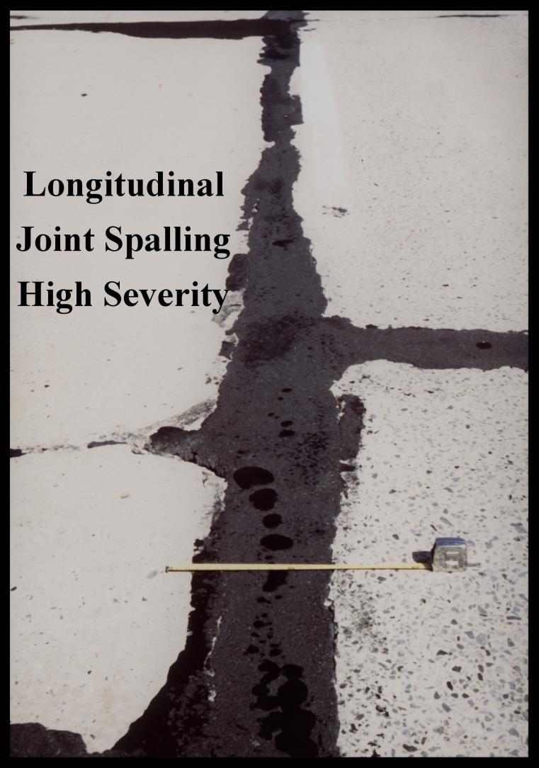
72 Longitudinal Joint Spalling Description: This condition is characterized by the cracking, breaking or chipping of slab edges adjacent to the longitudinal joint. It usually does not extend through the thickness of the slab, but meets the joint at an angle. It may be currently filled with bituminous material. If so, record the width of the spall as the width of the bituminous material. Possible Cause: Longitudinal joint spalling is generally caused by low quality concrete at the joint in combination with low air content in the concrete, wet-dry and freeze-thaw cycling and traffic loads. Rating Procedure: Rate the entire longitudinal joint (at the inside edge of slab) for longitudinal joint spalling. Record longitudinal joint spalling only when the total accumulated length (for all severity levels) is 25 feet or more. If there is more than one longitudinal joint within the lane being surveyed, count all joints in the total length of longitudinal joint spalling with the maximum total equal to the number of longitudinal joints times the segment length. Severity: Low: Medium: Average spalled width 1.0 in and < 3.0 in for an accumulated spalled length of at least 25 feet Average spalled width 3.0 in and < 6.0 in for an accumulated spalled length of at least 25 feet High: Average spalled width 6.0 in for an accumulated spalled length of at least 25 feet Extent: Record the total length of each severity. Example Rating: The accumulated length of spalling on a 1000-foot STAMPP segment is broken down into the following two amounts: 200 feet of medium severity and 150 feet of high severity longitudinal joint spalling. The rating for this section is 650 ft none, 200 ft medium and 150 ft high severity longitudinal joint spalling. 66

73 67
74 Bituminous Patching Description: This condition is characterized by an area of the original pavement, which has been repaired with bituminous material greater than 36 sq ft in area it may be a surface or full depth patch. Possible Cause: Bituminous patching may have been required for one of several reasons such as high severity spalling, broken slab, faulting or surface defects. Rating Procedure: Evaluate the full pavement lane width and determine the number of bituminous patches with an area exceeding 36 sq ft. Report the number and total area. Severity: None Extent: Count the number and record the area. Example Rating: A 1000-foot long, 11-foot wide STAMPP segment has three bituminous patches. One of the patches is 1 foot long and six feet wide (6 ft 2 ), the second is 7.4 feet long and half a lane width (40.7 ft 2 ) and the third is 9 feet long and a full lane width (99.0 ft 2 ). The rating for this STAMPP segment is two bituminous patches and ft 2 area. 68

75 Bituminous Patch Bituminous Patch 69

76 Portland Cement Concrete Patching Description: This condition is characterized by an area of the original pavement that has been repaired with portland cement concrete material greater than 36 sq ft in area. It may be a surface or full depth patch. Possible Cause: Portland cement concrete patching may have been required for one of several reasons such as high severity spalling, broken slab, faulting or surface defects. Rating Procedure: Evaluate the full pavement lane width and determine the number of portland cement concrete patches with an area exceeding 36 sq ft. Report as the number and total area of patches. Severity None. If a patch is distressed, the condition rating will be reflected in the pavement rating for both the patch and the distress. Extent: Count the number and record the total area of all patching. Example Rating: A 1000-foot long, 11-foot wide STAMPP segment has three portland cement concrete patches. One of the patches is 2 feet long and 5 feet wide (10 ft 2 ), the second is 8.2 feet long and half a lane width (45.1 ft 2 ) and the third is 6 feet long and a full lane width (66.0 ft 2 ). The rating for this STAMPP segment is two portland cement concrete patches with ft 2 total area. Concrete Patch 70
Straight Line Diagram. Montour 47. January 2019
 Straight Line Diagram Montour 47 January 2019 This document was produced by the Pennsylvania Department of Transportation (PENNDOT) as an internal management tool for State maintained highways and is not
Straight Line Diagram. Cameron 12. January 2018
 Straight Line Diagram Cameron 12 January 2018 This document was produced by the Pennsylvania Department of Transportation (PENNDOT) as an internal management tool for State maintained highways and is not
CONTINUOUSLY REINFORCED CONCRETE AND UNPAVED ROADS CONDITION SURVEY FIELD MANUAL PUBLICATION 343 APRIL 2017 PUB 343 (4-17)
") CONTINUOUSLY REINFORCED CONCRETE AND UNPAVED ROADS CONDITION SURVEY FIELD MANUAL PUBLICATION 343 APRIL 2017 PREPARED BY: BUREAU OF MAINTENANCE AND OPERATIONS ASSET MANAGEMENT DIVISION P.O. Box 3437 HARRISBURG,
CONTINUOUSLY REINFORCED CONCRETE AND UNPAVED ROADS CONDITION SURVEY FIELD MANUAL PUBLICATION 343 APRIL 2017 PREPARED BY: BUREAU OF MAINTENANCE AND OPERATIONS ASSET MANAGEMENT DIVISION P.O. Box 3437 HARRISBURG,
Blueprint for One of the Nation s Largest SCM Maintenance Programs
 Blueprint for One of the Nation s Largest SCM Maintenance Programs PA Department of Transportation Hydrologic & Hydraulic Studies Waterway Permitting Stormwater Design & Permitting Technical Course Development
Methodology for Defining Workforce Regions in the State System s Gap Analysis
 CLARION UNIVERSITY Methodology for Defining Workforce Regions in the State System s 2016-2026 Gap Analysis The purpose of this document is to lay out the methodology for defining the University Workforce
Pavement Distress Categories
 Pavement Distress Identification Asphalt Pavements Raymond Ong, Purdue University William Flora, INDOT Planning Joyce Stone, INDOT Pavement Engineering Samy Noureldin, INDOT Research Pavement Distress
Alligator Cracking. Light. Medium. High
 Alligator Cracking Description: A series of interconnecting cracks caused by fatigue failure on the asphalt concrete surface under repeated traffic loading. Causes: Loads in excess of the current pavement
BID ITEM WORKBOOK COSTARS-8 Maintenance, Repair, & Operation Equipment & Supplies ("MRO") BIDDER/CONTRACTOR DATA
 BIDDER/CONTRACTOR DATA") COSTARS-8 Maintenance, Repair, & Operation Equipment & Supplies ("MRO") BIDDER/CONTRACTOR DATA BIDDER/CONTRACTOR'S LEGAL NAME: D/B/A NAME, IF APPLICABLE: BIDDER ADDRESS: COUNTY LOCATED IN: PA Legislative
COSTARS-8 Maintenance, Repair, & Operation Equipment & Supplies ("MRO") BIDDER/CONTRACTOR DATA BIDDER/CONTRACTOR'S LEGAL NAME: D/B/A NAME, IF APPLICABLE: BIDDER ADDRESS: COUNTY LOCATED IN: PA Legislative
GENERAL PERMIT NUMBER WMGR114
 Description: The approval herein granted is limited to: 1. the processing of spent polyethylene glycol slurry containing silicon and silicon carbide or diamond ( waste ) for beneficial use in fresh slurry
LEVEL 1 ASSESSMENT FORM
 COMMONWEALTH OF PENNSYLVANIA DEPARTMENT OF ENVIRONMENTAL PROTECTION BUREAU OF SAFE DRINKING WATER LEVEL 1 ASSESSMENT FORM I. General Information PWS Name: PWSID #: Contact Name: Phone #: PWS Address: E-mail:
BID ITEM WORKBOOK COSTARS-6 Packaged Software BIDDER/CONTRACTOR DATA
 BIDDER/CONTRACTOR DATA BIDDER/CONTRACTOR'S LEGAL NAME: D/B/A NAME, IF APPLICABLE: BIDDER ADDRESS: COUNTY LOCATED IN: 1102 15th Street SW, Suite 102 Auburn, WA 98001 King PA Legislative House District Number
There has been much speculation
 Marcellus Education Fact Sheet Pennsylvania Dairy Farms and Marcellus Shale, 2007 2010 There has been much speculation about the implications of Marcellus shale development for Pennsylvania farms and farmers.
PROCEDURES FOR REVISIONS TO NATIONAL HIGHWAY SYSTEM CONNECTIONS TO MAJOR INTERMODAL FACILITIES
 PROCEDURES FOR REVISIONS TO NATIONAL HIGHWAY SYSTEM CONNECTIONS TO MAJOR INTERMODAL FACILITIES Pennsylvania Department of Transportation Transportation Planning Division April 2014 (Revised March 2018)
ASSOCIATED PENNSYLVANIA CONSTRUCTORS SUPPLEMENTAL ECMS ADVANCED INFORMATION LETTING MAY 24, 2018 (ALL WORK TO BE COMPLETED TO APPEAR IN THE PROPOSAL)
") ASSOCIATED PENNSYLVANIA CONSTRUCTORS Updated May 4, 2018 FULTON COUNTY SR 0000(FMC) #109343 PROPOSAL:$21.36 PLANS:$9.02 12X18:$11.07 24X36:$159.90 X-SEC:$7.48 12X18:$9.18 24X36:$132.60 This project involves
ASSOCIATED PENNSYLVANIA CONSTRUCTORS Updated May 4, 2018 FULTON COUNTY SR 0000(FMC) #109343 PROPOSAL:$21.36 PLANS:$9.02 12X18:$11.07 24X36:$159.90 X-SEC:$7.48 12X18:$9.18 24X36:$132.60 This project involves
Commonwealth of Pennsylvania
 Commonwealth of Pennsylvania Date: April 1, 2016 Subject: Children's Health Insurance Program Outreach Solicitation Number: RFQ 6100037762 Opening Date/Time: April 4, 2016 5:00 PM Addendum Number: 1 To
Streets Evaluation Manual
 Streets Evaluation Manual 1 Contents Introduction 2 Asphalt Pavement Distress 3 Evaluation 4 Surface Defects 4 Surface Deformation 6 Cracks 7 Patches and Potholes 11 Rating Pavement Surface Condition 12
If so, you should reconsider your grazing management!
 Grazing Management Conservation solutions for your Pennsylvania farm Do you have problems with Bare ground or compacted soil in your pasture? Slow forage growth? Low quality pasture? Standing water after
BID ITEM WORKBOOK COSTARS-13 Emergency Responder Vehicles BIDDER/CONTRACTOR DATA
 BIDDER/CONTRACTOR DATA BIDDER/CONTRACTOR'S LEGAL NAME: D/B/A NAME, IF APPLICABLE: BIDDER ADDRESS: COUNTY LOCATED IN: 2100 Washington Pike Heidelberg, Pa. 15106 Allgheny VENDOR NUMBER: 147187 Primary POC
DEPARTMENT OF ENVIRONMENTAL PROTECTION Bureau of Oil and Gas Management
 DOCUMENT NUMBER: ***-****-*** EFFECTIVE DATE: Month DD, YYYY DEPARTMENT OF ENVIRONMENTAL PROTECTION Bureau of Oil and Gas Management TITLE: Addressing Spills and Releases from Oil & Gas Wells and Related
BID ITEM WORKBOOK COSTARS-3 IT Hardware BIDDER/CONTRACTOR DATA
 BIDDER/CONTRACTOR DATA BIDDER/CONTRACTOR'S LEGAL NAME: D/B/A NAME, IF APPLICABLE: BIDDER ADDRESS: COUNTY LOCATED IN: VENDOR NUMBER: PA Legislative House District Number DGS Self-Certified Small Business
ASSOCIATED PENNSYLVANIA CONSTRUCTORS SUPPLEMENTAL ADVANCED INFORMATION LETTING JULY 17, 2014 (ALL WORK TO BE COMPLETED TO APPEAR IN THE PROPOSAL)
") ASSOCIATED PENNSYLVANIA CONSTRUCTORS SUPPLEMENTAL ADVANCED INFORMATION LETTING JULY 17, 2014 Updated June 30, 2014 LUZERNE COUNTY SR 309(W02) #102354 PROPOSAL:$25.20 PLANS:$6.24 The description and location
ASSOCIATED PENNSYLVANIA CONSTRUCTORS SUPPLEMENTAL ADVANCED INFORMATION LETTING JULY 17, 2014 Updated June 30, 2014 LUZERNE COUNTY SR 309(W02) #102354 PROPOSAL:$25.20 PLANS:$6.24 The description and location
BID ITEM WORKBOOK COSTARS-17 Waste, Recycling & Materials Handling Containers BIDDER/CONTRACTOR DATA
 BIDDER/CONTRACTOR DATA BIDDER/CONTRACTOR'S LEGAL NAME: D/B/A NAME, IF APPLICABLE: BIDDER ADDRESS: COUNTY LOCATED IN: VENDOR NUMBER: PA Legislative House District Number DGS Self-Certified Small Business
Legislative Budget and Finance Committee
 Legislative Budget and Finance Committee A JOINT COMMITTEE OF THE PENNSYLVANIA GENERAL ASSEMBLY Offices: Room 400 Finance Building, 613 North Street, Harrisburg Mailing Address: P.O. Box 8737, Harrisburg,
APPENDIX B CONTENTS. Chapter 5 - Pavement (Appendix B) July 01
 July 01") APPENDIX B CONTENTS B.1 Typical Pavement Distress Type - Severity Description... B-2 B.2 Identification of Distress Types for Asphalt Surfaced Pavements... B-3 B.3 Identification of Distress Types for
APPENDIX B CONTENTS B.1 Typical Pavement Distress Type - Severity Description... B-2 B.2 Identification of Distress Types for Asphalt Surfaced Pavements... B-3 B.3 Identification of Distress Types for
BID ITEM WORKBOOK COSTARS-13 Emergency Responder Vehicles BIDDER/CONTRACTOR DATA
 BIDDER/CONTRACTOR DATA BIDDER/CONTRACTOR'S LEGAL NAME: D/B/A NAME, IF APPLICABLE: BIDDER ADDRESS: COUNTY LOCATED IN: VENDOR NUMBER: Primary POC regarding IFB/Contract: Secondary POC regarding IFB/Contract:
BID ITEM WORKBOOK COSTARS-25 Municipal Work Vehicles BIDDER/CONTRACTOR DATA
 BIDDER/CONTRACTOR DATA BIDDER/CONTRACTOR'S LEGAL NAME: D/B/A NAME, IF APPLICABLE: BIDDER ADDRESS: COUNTY LOCATED IN: VENDOR NUMBER: PA Legislative House District Number 4162 LIBRARY RD PITTSBURGH, PA 15234
Asphalt Pavement Forensics: Understanding the Problem to Better Determine the Solution
 Asphalt Pavement Forensics: Understanding the Problem to Better Determine the Solution 63 rd Annual Asphalt Paving Conference FireKeepers Casino Hotel Battle Creek, Michigan March 6-7, 2019 1 Copyright
SUPPLEMENTAL ECMS ADVANCED INFORMATION JUNE 5, 2014 (ALL WORK TO BE COMPLETED TO APPEAR IN THE PROPOSAL)
") Updated on May 19, 2014 VENANGO COUNTY SR 308(DOI) #96906 PROPOSAL:$13.44 PLANS:$3.96 For the bituminous milling and resurfacing of various state routes throughout VENANGO COUNTY, Commonwealth of Pennsylvania,
Updated on May 19, 2014 VENANGO COUNTY SR 308(DOI) #96906 PROPOSAL:$13.44 PLANS:$3.96 For the bituminous milling and resurfacing of various state routes throughout VENANGO COUNTY, Commonwealth of Pennsylvania,
CHAPTER B TABLE OF CONTENTS
 July 2006 Page B-1 CHAPTER B TABLE OF CONTENTS B.00 Introduction B.01 Definitions B.02 Maintenance Levels B.03 Definition of Traveled Way B.04 Policy for Performing Roadbed Maintenance Work B.05 Surface
SUPPLEMENTAL ECMS ADVANCED INFORMATION AUGUST 10, 2017 (ALL WORK TO BE COMPLETED TO APPEAR IN THE PROPOSAL)
") Updated July 21, 2017 ALLEGHENY COUNTY SR 0000 #109397 PROPOSAL:$28.56 The description and location of the project is as follows: This work is the 3-year term maintenance if intelligent transportation
Updated July 21, 2017 ALLEGHENY COUNTY SR 0000 #109397 PROPOSAL:$28.56 The description and location of the project is as follows: This work is the 3-year term maintenance if intelligent transportation
HAWAII DEPARTMENT OF TRANSPORATION HIGHWAYS DIVISION PAVEMENT PREVENTIVE MAINTENANCE GUIDELINES JUNE 2003
 HAWAII DEPARTMENT OF TRANSPORATION HIGHWAYS DIVISION PAVEMENT PREVENTIVE MAINTENANCE GUIDELINES JUNE 2003 Reviewed and accepted by FHWA on September 29, 2003 Note: Guidelines was revised on to correct
LEVEL 2 ASSESSMENT FORM
 COMMONWEALTH OF PENNSYLVANIA DEPARTMENT OF ENVIRONMENTAL PROTECTION BUREAU OF SAFE DRINKING WATER LEVEL 2 ASSESSMENT FORM I. General Information PWS Name: PWSID #: Contact Name: Phone #: PWS Address: E-mail:
LONG TERM PAVEMENT PERFORMANCE PROGRAM DIRECTIVE
 LONG TERM PAVEMENT PERFORMANCE PROGRAM DIRECTIVE For the Technical Direction of the LTPP Program Program Area: Monitoring Directive Number: D-14 Date: March 1, 1999 Supersedes: D-13 Subject: Changes to
BUREAU OF WASTE MANAGEMENT. DIVISION OF MUNICIPAL and RESIDUAL WASTE GENERAL PERMIT WMGR028
 BUREAU OF WASTE MANAGEMENT DIVISION OF MUNICIPAL and RESIDUAL WASTE GENERAL PERMIT WMGR028 BENEFICIAL USE OF BAGHOUSE FINES OR SCRUBBER POND PRECIPITATES FROM HOT-MIX ASPHALT PLANTS Issued: August 1, 2017
General Permit WMGR116. Beneficial Use of Alternative Fuels for Circulating and Bubbling Fluidized Bed Boilers and Pulverized Coal-fired Boilers
 General Permit WMGR116 Beneficial Use of Alternative Fuels for Circulating and Bubbling Fluidized Bed Boilers and Pulverized Coal-fired Boilers Department of Environmental Protection Bureau of Waste Management
THE GOVERNOR GOVERNOR S OFFICE. Amendment to Proclamation
 5346 THE GOVERNOR GOVERNOR S OFFICE September 18, 2004 in Allegheny, Armstrong, Butler and Washington Counties due to widespread and unusually severe storms, heavy rain, high winds and general population
GENERAL PERMIT WMGM020 RECOVERY AND BENEFICIAL USE OF FERROUS AND NONFERROUS METALS; AND REMOVAL OF UNBURNED
 GENERAL PERMIT WMGM020 RECOVERY AND BENEFICIAL USE OF FERROUS AND NONFERROUS METALS; AND REMOVAL OF UNBURNED MATERIAL FROM MUNICIPAL WASTE INCINERATION FACILITIES DEPARTMENT OF ENVIRONMENTAL PROTECTION
Report Number: CP2C
 Evaluation of RAC-O-HB Project FRE I-5-PM 0-38 HB project on I-5 north of Bakersfield Report Number: CP2C- 2007-103 July 7, 2007 California Pavement Preservation Center 203 Langdon Hall California State
LAND APPLICATION OF RESIDUAL WASTE ANNUAL OPERATION REPORT. Instructions
 2520>FM>LWM0408 ev. 8/97 25 PA Code 291.222 DEPATMENT OF ENVIONMENTAL POTECTION BUEAU OF LAND ECYCLING AND WASTE MANAGEMENT LAND APPLICATION OF ESIDUAL WASTE ANNUAL OPEATION EPOT Instructions 1. This report
550 Surface Treatments
 Table of Contents 550 Surface Treatments... 550-1 550.1 Introduction... 550-1 551 Crack Sealing... 550-1 551.1 Project Selection... 550-1 551.2 Design Considerations... 550-1 552 Chip Sealing... 550-2
ASSOCIATED PENNSYLVANIA CONSTRUCTORS SUPPLEMENTAL ECMS ADVANCED INFORMATION LETTING JULY 12, 2018 (ALL WORK TO BE COMPLETED TO APPEAR IN THE PROPOSAL)
") Updated July 9, 2018 BUCKS COUNTY SR 1017(SC1) #15341 PROPOSAL:$22.80 This project is for the applying of seal coat to existing bituminous roadway on various state routes (32.33 segment miles) in Bucks
Updated July 9, 2018 BUCKS COUNTY SR 1017(SC1) #15341 PROPOSAL:$22.80 This project is for the applying of seal coat to existing bituminous roadway on various state routes (32.33 segment miles) in Bucks
MICHIGAN DEPARTMENT OF TRANSPORTATION SPECIAL PROVISION FOR MATERIALS AND WORKMANSHIP PAVEMENT WARRANTY
 MICHIGAN DEPARTMENT OF TRANSPORTATION SPECIAL PROVISION FOR MATERIALS AND WORKMANSHIP PAVEMENT WARRANTY CFS:EMC 1 of 8 APPR:KPK:CJB:06-13-17 FHWA:APPR:06-14-17 a. Description. The materials and workmanship
2399 Pavement Surface Smoothness
 2399 Pavement Surface Smoothness 2399.1 DESCRIPTION The final mainline and all other pavement surfaces where the posted vehicle speed is 30 mph [48 km/hr] or greater shall be measured using an Inertial
Local Nitrogen Goals Across Different Geographies
 Local Nitrogen Goals Across Different Geographies Lisa Schaefer Co-Chair of PA Phase III WIP Local Area Goals Workgroup County Commissioners Association of Pennsylvania Matt Johnston University of Maryland
SUPPLEMENTAL ECMS ADVANCED INFORMATION DECEMBER 22, 2016 (ALL WORK TO BE COMPLETED TO APPEAR IN THE PROPOSAL)
") SUPPLEMENTAL ECMS ADVANCED INFORMATION DECEMBER 22, 2016 (ALL WORK TO BE COMPLETED TO APPEAR IN THE PROPOSAL) Updated December 5, 2016 SCHUYLKILL COUNTY SR 4027(M89) #99482 PROPOSAL:$21.60 PLANS:$1.68
SUPPLEMENTAL ECMS ADVANCED INFORMATION DECEMBER 22, 2016 (ALL WORK TO BE COMPLETED TO APPEAR IN THE PROPOSAL) Updated December 5, 2016 SCHUYLKILL COUNTY SR 4027(M89) #99482 PROPOSAL:$21.60 PLANS:$1.68
Biosolids Quality. Enhancement Plan. For more information, visit keyword: Biosolids.
 Biosolids Quality Enhancement Plan For more information, visit www.dep.state.pa.us, keyword: Biosolids. Biosolids Quality Enhancement Plan INTRODUCTION The beneficial use of biosolids has become a growing
SPECIAL CONDITIONS GENERAL PERMIT WMGM025
 A. Authorization: This general permit authorizes the grinding, shredding, crushing, screening and/or beneficial use of construction waste materials as follows: 1. Activity authorized at the permanent facility:
PCC Pavement Rideability
 Supplemental Technical Specification for PCC Pavement Rideability SCDOT Designation: SC-M-502 (04/16) 1. SCOPE 1.1. The Resident Construction Engineer (RCE) will evaluate Portland cement concrete (PCC)
14, 2019 MERCER COUNTY SR 173(491) # PROPOSAL:$11.40 PLANS:$5.40 X-SEC:$ X18:$ X36:$39.00
 # PROPOSAL:$11.40 PLANS:$5.40 X-SEC:$ X18:$ X36:$39.00") Updated January 14, 2019 MERCER COUNTY SR 173(491) #100019 PROPOSAL:$11.40 PLANS:$5.40 X-SEC:$2.20 12X18:$2.70 24X36:$39.00 For the construction or Improvement of a certain section of STATE HIGHWAY in
Updated January 14, 2019 MERCER COUNTY SR 173(491) #100019 PROPOSAL:$11.40 PLANS:$5.40 X-SEC:$2.20 12X18:$2.70 24X36:$39.00 For the construction or Improvement of a certain section of STATE HIGHWAY in
Distresses within Asphalt Concrete Pavements and use of repave tool for Pavement Distress Management Paige Jordan 03/ 01/ 2016 Bradley University
 Distresses within Asphalt Concrete Pavements and use of repave tool for Pavement Distress Management Paige Jordan 03/ 01/ 2016 Bradley University Page 1 Introduction: Distresses A distressed pavement is
Széchenyi István University Faculty of Architecture, Civil Engineering and Transport Sciences Department of Transport Infrastructure.
 Széchenyi István University Faculty of Architecture, Civil Engineering and Transport Sciences Department of Transport Infrastructure Pavement failures Themes of lecture Failure types of pavements Different
TRANSVERSE CRACKING PROGRESSION IN ASPHALT SHOULDERS ADJACENT TO CONCRETE PAVEMENTS
 TRANSVERSE CRACKING PROGRESSION IN ASPHALT SHOULDERS ADJACENT TO CONCRETE PAVEMENTS Sam Owusu-Ababio and Robert Schmitt University of Wisconsin-Platteville, U.S.A. Abstract The shoulder forms an integral
GENERAL PERMIT PAG-02 FOR COVERAGE UNDER GENERAL NPDES PERMIT FOR STORMWATER DISCHARGES ASSOCIATED WITH CONSTRUCTION ACTIVITIES FACT SHEET
 COMMONWEALTH OF PENNSYLVANIA DEPARTMENT OF ENVIRONMENTAL PROTECTION BUREAU OF WATERSHED MANAGEMENT GENERAL PERMIT PAG-02 FOR COVERAGE UNDER GENERAL NPDES PERMIT FOR STORMWATER DISCHARGES ASSOCIATED WITH
Appendix A Pavement Failure Identification
 Pavement Failure Identification A-1 Appendix A Pavement Failure Identification IDENTIFYING AND CORRECTING PAVEMENT FAILURES The key to proper maintenance of asphalt pavements is to understand the causes
The Right Treatment for Resurfacing Projects. Clark Morrison, PE February 7, 2017
 The Right Treatment for Resurfacing Projects Clark Morrison, PE February 7, 2017 The Right Treatment for Resurfacing Projects Selecting Mix Type Pre-Overlay Treatment Alligator Cracking Transverse Cracking
603 - ASPHALT PAVEMENT SMOOTHNESS SECTION 603 ASPHALT PAVEMENT SMOOTHNESS
 SECTION 603 ASPHALT PAVEMENT SMOOTHNESS 603.1 DESCRIPTION Determine the smoothness of the pavement surface and correct the deficiencies as specified in the Contract Documents. For the purposes of this
Introduction to Pavement Overlays
 Introduction to Pavement Overlays Course No: C02-046 Credit: 2 PDH J. Paul Guyer, P.E., R.A., Fellow ASCE, Fellow AEI Continuing Education and Development, Inc. 9 Greyridge Farm Court Stony Point, NY 10980
SCHUYLKILL COUNTY SR 125(JFR) # PROPOSAL:$20.76 PLANS 8.5X11:$1.20
 # PROPOSAL:$20.76 PLANS 8.5X11:$1.20") SCHUYLKILL COUNTY SR 125(JFR) #111844 PROPOSAL:$20.76 PLANS 8.5X11:$1.20 The emergency project consists of rock protection and underpinning of the piers to prevent future scouring and other miscellaneous
SCHUYLKILL COUNTY SR 125(JFR) #111844 PROPOSAL:$20.76 PLANS 8.5X11:$1.20 The emergency project consists of rock protection and underpinning of the piers to prevent future scouring and other miscellaneous
SUPPLEMENTAL ECMS ADVANCED INFORMATION JULY 14, 2016 (ALL WORK TO BE COMPLETED TO APPEAR IN THE PROPOSAL)
") Updated June 27, 2016 BEAVER COUNTY SR 7446(LBB) #92912 PROPOSAL:$54.72 PLANS:$42.46 12X18:$52.11 24X36:$752.70 EXSTRUCT:$48.62 12X18:$59.67 24X36:$861.90 The description and location of the project is
Updated June 27, 2016 BEAVER COUNTY SR 7446(LBB) #92912 PROPOSAL:$54.72 PLANS:$42.46 12X18:$52.11 24X36:$752.70 EXSTRUCT:$48.62 12X18:$59.67 24X36:$861.90 The description and location of the project is
11, 2019 MONTOUR COUNTY SR 2006(026) # PROPOSAL:$16.56 PLANS:$ X18:$ X36:$19.50
 # PROPOSAL:$16.56 PLANS:$ X18:$ X36:$19.50") Updated February 11, 2019 MONTOUR COUNTY SR 2006(026) #112211 PROPOSAL:$16.56 PLANS:$1.10 12X18:$1.35 24X36:$19.50 The description and location of the project are as follows: Emergency repairs due to flood
Updated February 11, 2019 MONTOUR COUNTY SR 2006(026) #112211 PROPOSAL:$16.56 PLANS:$1.10 12X18:$1.35 24X36:$19.50 The description and location of the project are as follows: Emergency repairs due to flood
STANDARD CONDITIONS GENERAL PERMIT WMGM042
 STANDARD CONDITIONS GENERAL PERMIT WMGM042 A. Authorization: This general permit authorizes the processing (mixing or blending) of (i) animal manure, (ii) grease trap waste (collected from restaurants,
Pavement Management Systems
 Pavement Management Systems Basics and Benefits David R. Johnson, P.E. Regional Engineer Asphalt Institute Rocky Mountain Region djohnson@asphaltinstitute.org Presentation Outline Definition Requirements
SUMMARY OF KEY REQUIREMENTS FOR
 SUMMARY OF KEY REQUIREMENTS FOR SURFACE WATER IDENTIFICATION PROTOCOL COMMONWEALTH OF PENNSYLVANIA Department of Environmental Protection For more information, visit us through the PA PowerPort at www.state.pa.us
PAVEMENT MARKINGS. Presented by: Tom Clayton Director of Training and Member Services CAPA/RMAEC
 PAVEMENT MARKINGS Presented by: Tom Clayton Director of Training and Member Services CAPA/RMAEC ASPHALT SURFACES There are different types and textures of asphalt surfaces in which markings are applied.
U.S. DEPARTMENT OF HUD 04/11/2017 STATE: PENNSYLVANIA HOUSING TRUST FUND INCOME LIMITS
 Allentown-Bethlehem-Easton, PA-NJ MSA Allentown-Bethlehem-Easton, PA HMFA HTF LIMITS 15400 17600 20420 24600 28780 32960 37140 41320 30% Limits 15400 17600 19800 22000 23800 25550 27300 29050 Altoona,
Standard Practice for Roads and Parking Lots Pavement Condition Index Surveys 1
 Designation: D 6433 07 Standard Practice for Roads and Parking Lots Pavement Condition Index Surveys 1 This standard is issued under the fixed designation D 6433; the number immediately following the designation
Micro-Surface Premature Distress SH 19 Hopkins County, Paris District
 Micro-Surface Premature Distress SH 19 Hopkins County, Paris District Research Report RR-16-03 Prepared for Texas Department of Transportation Maintenance Division Prepared by Texas A&M Transportation
SITE ASSESSMENT SAMPLING REQUIREMENTS AT REGULATED STORAGE TANK SYSTEM CLOSURES
 SITE ASSESSMENT SAMPLING REQUIREMENTS AT REGULATED STORAGE TANK SYSTEM CLOSURES Bureau of Environmental Cleanup and Brownfields Division of Storage Tanks November 1, 2016 2630-BK-DEP4699 11/2016 An Equal
PAVEMENT MANAGEMENT INFORMATION SYSTEM. Rater s Manual FOR FISCAL YEAR 2010 APR. 2009
 PAVEMENT MANAGEMENT INFORMATION SYSTEM Rater s Manual FOR FISCAL YEAR 2010 APR. 2009 Pavement Management Information System Rater's Manual Fiscal Year 2010 Texas Department of Transportation April 2,
Brad Hall Midstream & Marketing
 Brad Hall Midstream & Marketing October 17, 2012 Overview Lines of Business Marketing Generation Midstream Natural Gas >100 Bcf > 30,000 locations 33 LDCs Power > 2 MM MWhrs > 10,000 locations 19 EDCs
ASSOCIATED PENNSYLVANIA CONSTRUCTORS SUPPLEMENTAL ECMS ADVANCED INFORMATION LETTING JULY 26, 2018 (ALL WORK TO BE COMPLETED TO APPEAR IN THE PROPOSAL)
") Updated July 23, 2018 LACKAWANNA COUNTY SR 8031(WWR) #109012 Moved to 7/26/18 from 7/12/18 PROPOSAL:$14.40 PLANS 8.5x11:$4.80 For the rehabilitation and improvement of certain sections of Varies STATE
Updated July 23, 2018 LACKAWANNA COUNTY SR 8031(WWR) #109012 Moved to 7/26/18 from 7/12/18 PROPOSAL:$14.40 PLANS 8.5x11:$4.80 For the rehabilitation and improvement of certain sections of Varies STATE
BID ITEM WORKBOOK COSTARS-35 Furniture and Window Treatments BIDDER/CONTRACTOR DATA
 BIDDER/CONTRACTOR DATA BIDDER/CONTRACTOR'S LEGAL NAME: D/B/A NAME, IF APPLICABLE: BIDDER ADDRESS: COUNTY LOCATED IN: Steelcase Inc. 901 44th Street SE Mail Code: CH-2W-08 Grand Rapids, MI 49508 USA PA
SD95-16-G1. SD Department of Transportation Office of Research. Rural Road Condition Survey Guide
 SD95-16-G1 SD Department of Transportation Office of Research Rural Road Condition Survey Guide Prepared by ERES Consultants, Inc. 505 West University Champaign, IL 61820-3915 July 1995 DISCLAIMER The
PREVENTATIVE MAINTENANCE
 PREVENTATIVE MAINTENANCE The Free Dictionary = The care and servicing by personnel for the purpose of maintaining equipment and facilities in satisfactory operating condition by providing for systematic
Appendix B. Pavement Guidelines for Treatment of High Stress Locations
 Appendix B Pavement Guidelines for Treatment of High Stress Locations PAVEMENT GUIDELINES FOR TREATMENT OF HIGH STRESS LOCATIONS BACKGROUND: These guidelines are intended to be used to reduce or eliminate
OKLAHOMA DEPARTMENT OF TRANSPORTATION SPECIAL PROVISION FOR PAVEMENT AND BRIDGE DECK SMOOTHNESS
 430-2QA(a-i) 09 OKLAHOMA DEPARTMENT OF TRANSPORTATION SPECIAL PROVISION FOR PAVEMENT AND BRIDGE DECK SMOOTHNESS These Special Provisions amend and where in conflict, supersede applicable sections of the
IGGA Guide Specification: Conventional Diamond Grinding for Pavement Preservation Introduction
 IGGA Guide Specification: Conventional Diamond Grinding for Pavement Preservation Introduction This standard developed, by the International Grooving and Grinding Association (IGGA), specifies the procedures
ASSOCIATED PENNSYLVANIA CONSTRUCTORS SUPPLEMENTAL ECMS ADVANCED INFORMATION LETTING MARCH 1, 2018 (ALL WORK TO BE COMPLETED TO APPEAR IN THE PROPOSAL)
") As of February14, 2018 SNYDER COUNTY SR 2007(012) #93607 PROPOSAL:$16.56 PLANS:$4.40 12X18:$5.40 24X36:$78.00 The description and location of the project are as follows: The work is the furnishing and
As of February14, 2018 SNYDER COUNTY SR 2007(012) #93607 PROPOSAL:$16.56 PLANS:$4.40 12X18:$5.40 24X36:$78.00 The description and location of the project are as follows: The work is the furnishing and
Rural Flexible Roads Manual
 Volume 1 of 3 Pavement Surface Condition Index Department of Transport, Tourism and Sport October 2013 DOCUMENT CONTROL SHEET Client Department of Transport, Tourism and Sport Author PMS Pavement Management
An Assessment of the Economic Impacts of the Pennsylvania Dairy Industry 1
 An Assessment of the Economic Impacts of the Pennsylvania Dairy Industry 1 Executive Summary Steven Deller, Mark Stephenson and Chuck Nicholson 2 To assess the contribution of dairy to the Pennsylvania
PAVEMENT SURFACE CONDITION RATING MANUAL
 PAVEMENT SURFACE CONDITION RATING MANUAL Fifth Edition August, 2016 British Columbia Ministry of Transportation and Infrastructure Construction Maintenance Branch Prepared by: Opus International Consultants
Pavement Rehabilitation Options in Indiana. Dave Holtz Tommy E. Nantung Lisa Egler-Kellems Indiana Department of Transportation
 Pavement Rehabilitation Options in Indiana Dave Holtz Tommy E. Nantung Lisa Egler-Kellems Indiana Department of Transportation Decision to select treatment options Rehabilitation Treatment Overview Objectives
SUPPLEMENTAL ECMS ADVANCED INFORMATION APRIL 6, 2017 (ALL WORK TO BE COMPLETED TO APPEAR IN THE PROPOSAL)
") Updated March 20, 2017 ALLEGHENY COUNTY SR 3088(05) #106380 PROPOSAL:$23.40 PLANS:$11.88 12X18:$14.58 24X36:$210.60 EXSTRUCT:$3.08 12X18:$3.78 24X36:$54.60 The description and location of the project is
Updated March 20, 2017 ALLEGHENY COUNTY SR 3088(05) #106380 PROPOSAL:$23.40 PLANS:$11.88 12X18:$14.58 24X36:$210.60 EXSTRUCT:$3.08 12X18:$3.78 24X36:$54.60 The description and location of the project is
BID ITEM WORKBOOK COSTARS-14 Recreational & Fitness Equipment BIDDER/CONTRACTOR DATA
 BIDDER/CONTRACTOR DATA BIDDER/CONTRACTOR'S LEGAL NAME: D/B/A NAME, IF APPLICABLE: BIDDER ADDRESS: COUNTY LOCATED IN: VENDOR NUMBER: PA Legislative House District Number River Valley Recreation York 94
SECTION 14 - RESTORATION OF SURFACES TABLE OF CONTENTS
 SECTION 14 - RESTORATION OF SURFACES TABLE OF CONTENTS Section Page SECTION 14 RESTORATION OF SURFACES... 14.1 14-1 GENERAL... 14.1 14-2 PRIVATE ROADS... 14.1 14-3 STREETS AND PARKING LOTS... 14.1 14-3.01
Pavement Rehabilitation Selection Understanding the Problem
 Pavement Rehabilitation Selection Understanding the Problem Pavement assessment is the first step in making good decisions. The condition of the existing pavement is assessed through: Pavement History
BID ITEM WORKBOOK COSTARS-6 Software BIDDER/CONTRACTOR DATA
 COSTARS-6 Software BIDDER/CONTRACTOR DATA BIDDER/CONTRACTOR'S LEGAL NAME: D/B/A NAME, IF APPLICABLE: BIDDER ADDRESS: COUNTY LOCATED IN: VENDOR NUMBER: PA Legislative House District Number DGS Self-Certified
$600,000,000 $500,000,000 $400,000,000 $300,000,000 $200,000,000 $100,000,000
 $600,000,000 $500,000,000 $400,000,000 $300,000,000 $200,000,000 $100,000,000 $- Other Programs Highway Program $800,000,000 $700,000,000 $600,000,000 $500,000,000 $400,000,000 $300,000,000 $200,000,000
Cold In-Place Recycling with Expanded Asphalt B-335 COLD IN-PLACE RECYCLING WITH EXPANDED ASPHALT OPSS 335
 B-335 COLD IN-PLACE RECYCLING WITH EXPANDED ASPHALT OPSS 335 335.1 GENERAL Use of Cold In-Place Recycled Expanded Asphalt Mix (CIREAM) is recommended by the Regional Geotechnical Section on a work-project
UNDERSTANDING PMIS: RIDE, PATCHING, AND OTHER FACTORS. Darlene C. Goehl, P.E. Dist. Pavement-Materials Engr. TxDOT - BRY
 UNDERSTANDING PMIS: RIDE, PATCHING, AND OTHER FACTORS Darlene C. Goehl, P.E. Dist. Pavement-Materials Engr. TxDOT - BRY Outline 1 What is PMIS 3 2 3 Data Collection Distresses 4-6 7-9 4 How Scores are
SHRP2 Renewal Project R23 PAVEMENT RENEWAL SOLUTIONS
 SHRP2 Renewal Project R23 PAVEMENT RENEWAL SOLUTIONS Pavement Design Section Roadway Engineering Group Arizona Department of Transportation December, 2016 ABSTRACT One of the goals for the creation of
ATTACHMENT 50-1: PERFORMANCE AND MEASUREMENT TABLE
 1) PAVEMENT 1.1 Ride quality All roadways have a smooth surface course (including bridge deck approaches, covers, gratings, frames and boxes). 24 hours 28 days 6 months a. Measurement of International
BID ITEM WORKBOOK COSTARS-36 Appliances, Cafeteria Equipment, and Supplies BIDDER/CONTRACTOR DATA
 BIDDER/CONTRACTOR DATA BIDDER/CONTRACTOR'S LEGAL NAME: BIDDER 4501 Westport Drive Mechanicsburg, PA 17055 Cumberland PA Legislative House District Number PA Legislative Senate District Number VENDOR NUMBER:
Fundamentals of Jointing for Volume Change in Concrete
 Fundamentals of Jointing for Volume Volume Changes in Concrete Concrete is at its greatest volume when it is freshly placed. As the concrete cures and hardens, water is consumed in the chemical reaction
WARRANTIES IN STATE CONTRACTS FOR HIGHWAY CONSTRUCTION
 WARRANTIES IN STATE CONTRACTS OR HIGHWAY CONSTRUCTION Project: 00-2P Louisiana Department of Transportation and Development OVERVIEW In 1997, Louisiana House of Representatives passed Bill Number 1698,
Minnesota Airport System Pavement Evaluation 2010 Update
 Minnesota Airport System Pavement Evaluation 2010 Update Park Rapids Municipal Airport (PKD) Park Rapids, Minnesota Prepared for: Office of Aeronautics Minnesota Department of Transportation 222 East Plato
California Department of Transportation
 INTERIM CALTRANS AUTOMATED PAVEMENT CONDITION SURVEY California Department of Transportation Interim version: October, 29 Pavement Evaluation Manual C A L T R A N S P A V E M E N T M A N A G E M E N T
IGGA Guide Specification: Conventional Diamond Grinding of City Streets Introduction
 IGGA Guide Specification: Conventional Diamond Grinding of City Streets Introduction This standard developed, by the International Grooving and Grinding Association (IGGA), specifies the procedures for
BEAVER COUNTY SR 68(B38) # PROPOSAL:$26.64 PLANS:$ X18:$ X36:$222.30
 # PROPOSAL:$26.64 PLANS:$ X18:$ X36:$222.30") ASSOCIATED PENNSYLVANIA CONSTRUCTORS SUPPLEMENTAL ECMS ADVANCED INFORMATION LETTING MARCH 29, 2018 Update March 13, 2018 CHESTER COUNTY SR 23(ELV) #107680 PROPOSAL:$22.80 PLANS:$32.56 12X18:$39.96 24X36:$577.20
ASSOCIATED PENNSYLVANIA CONSTRUCTORS SUPPLEMENTAL ECMS ADVANCED INFORMATION LETTING MARCH 29, 2018 Update March 13, 2018 CHESTER COUNTY SR 23(ELV) #107680 PROPOSAL:$22.80 PLANS:$32.56 12X18:$39.96 24X36:$577.20
ASPHALT MIX DESIGNER
 ASPHALT MIX DESIGNER EFFECT OF MIX DESIGN ON PERFORMANCE AND CONSTRUCTION OF HMA Module 8 Module 8 1, July 2005 8-1 QUALITY Meets or Exceeds the Expectations or Needs of the Customer Module 8 2, July 2005