REMOTE SENSING APPROACHES FOR MONITORING OF EMISSIONS FROM LAND COVER CHANGE
|
|
|
- Ethan Nicholson
- 5 years ago
- Views:
Transcription
1 REMOTE SENSING APPROACHES FOR MONITORING OF EMISSIONS FROM LAND COVER CHANGE Alessandro Baccini Contact: A. Baccini BioCarbon Fund Initiative for Sustainable Forest Landscapes Landscape-level carbon accounting Washington DC, January 26-27, 2016
2 Outline Monitoring of emissions : Aboveground carbon pool monitoring Remote Sensing/IPCC approaches Direct measurements of carbon density changes (Deforestation, Degradation, Gain) Trees Outside Forest Changes in Soil Carbon
3 IPCC guidelines

 Reduce")


4 Biomass DRC= 17 Billion t C Deforestation (tc/ha) (tc/ha) Reduce uncertainty in carbon cycle studies Input for REDD/carbon Market Stock Flow Approach CO 2 Emissions 1990/2000
 Combine & Assign (CA) Approach Extension of SM, GIS and multi-layers information (Gibbs et al. 2007, Tyukavina et al.")
 Direct Remote Sensing (DR) Approach Empirical Models where RS data is calibrated to field estimates (Baccini et al.")
5 Large Area Carbon Estimation Forest Inventories Stratify & Multiply (SM) Approach Assign an average biomass value to land cover/vegetation type map (Asner et Al. 2010) Combine & Assign (CA) Approach Extension of SM, GIS and multi-layers information (Gibbs et al. 2007, Tyukavina et al ) Ecological Models (EM) Approach Remote sensing to parameterize the model (Hurtt et al. 2004) Direct Remote Sensing (DR) Approach Empirical Models where RS data is calibrated to field estimates (Baccini et al. 2004, 2008, 2012, Saatchi et al. 2007, 2011, Blackard et al. 2008) Goetz, Baccini et al. 2009
 Baccini and Friedl 2007, Asner et al.")
6 Stratify & Multiply (SM) Vegetation Map - 10 Strata Adequate number of samples required in each class Biomass (Tons/Ha) Biomass strata Errors in thematic map Land cover only partially related to biomass (e.g. within class variability) Baccini and Friedl 2007, Asner et al. 2010


7 Satellite Information Two types of information: Point data and Image data ICESat GLAS (Points)

8 Field observation network & calibration >300 locations > 30,000 trees measured Columbia Ecuador Bolivia Brazil Gabon DRC Uganda Tanzania Vietnam Cambodia Indonesia


9 A.Ba Pantropical Forest Carbon Mapped with Satellite and Field Observations Baccini et al CT1 Amazon Basin detail from the map DRC detail from the map PNG detail from the map Error 25 Mg C ha -1 Error 19 Mg C ha -1 Error 24 Mg C ha -1


10 Recent work Landsat circa year 2000 RGB: 4,5,7 (Hansen et al. 2013) GLAS based biomass density estimates (Baccini et al. 2012) Based on similar approach of Baccini et al. 2012

11 Improvement in Spatial Resolution

12 Landsat Based Biomass Density (Yr. 2000)

13 Landsat Annual Biomass Loss from Deforestation Biomass reference year 2000 Landsat biomass density circa 2000 combined with Hansen et al deforestation
14 Annual Gross Emissions from Deforestation Zarin et al. 2015

15 No need to define Deforestation and Degradation

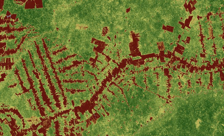
16 Carbon density trajectories over time and space Time series approach based on change point analysis For each 500 m x 500 m pixel we identify the trajectory of carbon density


17 Mg/ha Continuous spatially explicit carbon density change with measurable uncertainty Gain Gain = 59.2 StdEr = 24.2 P-V = Mg/ha Loss Loss = StdEr =8.4 P-V = Mg/ha Stable StdEr = 46.1 P-V = km x 215 km High : 128 High : -1 High : 293


18 Mg/ha Consistent with deforestation and sensitive to degradation? Deforestation Landsat based (30 m resolution) Hansen et al Gain Mg/ha Loss Gain = 59.2 StdEr = 24.2 P-V = Loss = StdEr =8.4 P-V = Mg/ha Stable StdEr = 46.1 P-V = km x 215 km High : 128 High : -1 High : 293
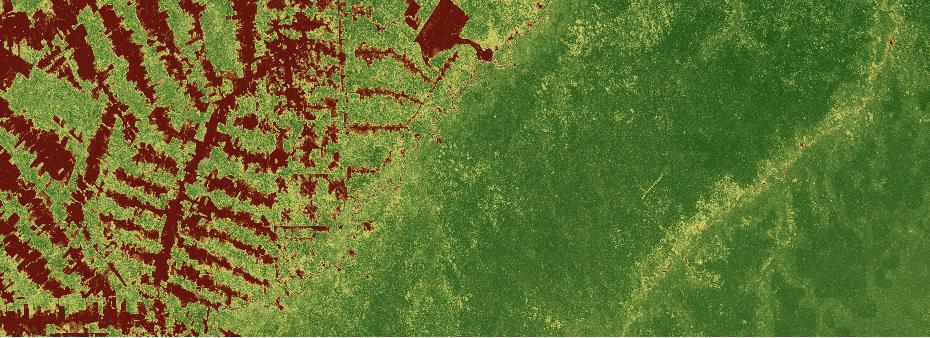
19 South East Asia Biomass change < Kilometers Kilometers
20 South East Asia Biomass change < Kilometers Kilometers Deforestation Landsat based (30 m resolution) Hansen et al. 2014

21

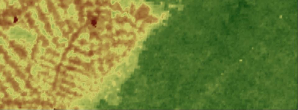
22 Uncertainty Associated to Change
23 Democ. Rep. Congo Annual Carbon Net Loss and Gain Baccini et al In review Nature


24 Trees Outside Forest Trees that do not meet the criteria of Forest It depends on Forest definition/country/agency Monitoring requires high resolution RS Planet Lab data 3-5 m resolution
25 SUMMARY Direct approach to quantify changes in carbon density over time and space Based on multiple annual observations, improvement over the T1 T2 approach Globally consistent, continuous, no need to classify forest and land cover change Fewer inputs resulting in smaller uncertainty Preliminary results are encouraging, what about attribution?
26 Summary Errors from allometry are relatively small Spatial aggregation reduce uncertainty in the estimates Different vegetation types tent do show different errors Biomass density maps can help in region with few field data There is the need for better remote sensing data Airborne LiDAR significantly improve the estimates (Baccini & Asner, 2014)
Nadine Laporte Woods Hole Research Center
 Mapping Tropical Aboveground Biomass with MODIS & LiDAR sensors: Application to REDD Nadine Laporte Woods Hole Research Center A. Baccini, W. Walker, S. Goetz, M. Sun, J. Kellndorfer Atelier International
Integration of forest inventories with remotely sensed data for biomass mapping: First results for tropical Africa
 Integration of forest inventories with remotely sensed data for biomass mapping: First results for tropical Africa Alessandro Baccini Nadine Laporte Scott J. Goetz Mindy Sun Wayne Walker Jared Stabach
Aboveground carbon loss in Democratic Republic of the Congo
 Jurisdictional Approaches to Green Development Jurisdictional-scale carbon accounting: evaluating options Aboveground carbon loss in Democratic Republic of the Congo Study and Presentation by: Alexandra
DEFORESTATION EMISSIONS IN THE GLOBAL CONTEXT
 DEFORESTATION EMISSIONS IN THE GLOBAL CONTEXT A Winrock and Woods Hole Collaboration merged with the Global Carbon Project and the University of East Anglia 3 December 2012 18:30 20:00 AGENDA 18:30 Welcome,
IIASA experience in analyzing global forest datasets
 IIASA experience in analyzing global forest datasets Dmitry Schepaschenko, Myroslava Lesiv, Aline Moisnier, Steffen Fritz Marie Curie FP7-MC-IIF: SIFCAS Independent monitoring GHG emission Modeling Biomass
ABSTRACT DATA SETS. Professor Matthew C. Hansen, Department of. Geographical Sciences
 ABSTRACT Title of Document: CHARACTERIZING FOREST DISTURBANCE DYNAMICS IN THE HUMID TROPICS USING OPTICAL AND LIDAR REMOTELY SENSED DATA SETS Alexandra Tyukavina, Ph.D., 2015 Directed by: Professor Matthew
Forestry and Agricultural Greenhouse Gas Modeling Forum # Shepherdstown, WV
 Forestry and Agricultural Greenhouse Gas Modeling Forum #4 March 6-8, 6 2007 Shepherdstown, WV Overview of scientific, technical and methodological issues related to reducing emissions from deforestation
Measuring global forest biomass: current
 Measuring global forest biomass: current status and new developments Shaun Quegan University of Sheffield & National Centre for Earth Observation Fate of anthropogenic CO 2 emissions (2005 2014 average)
FOREST MEASUREMENT AND MONITORING WORKSHOP September 4-5 Puyo, Ecuador
 FOREST MEASUREMENT AND MONITORING WORKSHOP September 4-5 Puyo, Ecuador Wayne Walker, Alessandro Baccini, Nadine Laporte, Josef Kellndorfer, and Scott Goetz The Woods Hole Research Center www.whrc.org Supported
Quantifying forest degradation and associated drivers in the Congo Basin Aurélie C. Shapiro World Wide Fund for Nature (WWF)
") Quantifying forest degradation and associated drivers in the Congo Basin Aurélie C. Shapiro World Wide Fund for Nature (WWF) Science Team meeting #16 Phase 3 Kick off JAXA TKSC/RESTEC HQ, Tsukuba/Tokyo,
Quantifying forest degradation and associated drivers in the Congo Basin Aurélie C. Shapiro World Wide Fund for Nature (WWF) Science Team meeting #16 Phase 3 Kick off JAXA TKSC/RESTEC HQ, Tsukuba/Tokyo,
Linking Remote Sensing and Economics: Evaluating the Effectiveness of Protected Areas in Reducing Tropical Deforestation
 Linking Remote Sensing and Economics: Evaluating the Effectiveness of Protected Areas in Reducing Tropical Deforestation Joe Maher 1 and Xiaopeng Song 2 1 University of Maryland, Department of Agricultural
Biomass Maps in the World Bank s Land Use Climate Result-based Finance
 Biomass Maps in the World Bank s Land Use Climate Result-based Finance Andres Espejo aespejo@worldbank.org Forest Carbon Partnership Facility BioCarbon Fund September 25, 2018 CCI Biomass 1 st User Workshop
Existing products and tools for country support
 NFMS and MRV FAO Forestry Existing products and tools for country support FAO Forestry www.fao.org/forestry Country Level HQ Level NFMS/MRV cooperation and coordination at HQ and national level P&Ms UN-REDD
People, Plots, and Pixels: The Role of Local CommuniGes and Indigenous Peoples in Forest Monitoring for REDD+
 People, Plots, and Pixels: The Role of Local CommuniGes and Indigenous Peoples in Forest Monitoring for REDD+ Drs. Alessandro Baccini and Wayne Walker The Woods Hole Research Center Chris Meyer Environmental
County- Scale Carbon Estimation in NASA s Carbon Monitoring System
 County- Scale Carbon Estimation in NASA s Carbon Monitoring System Ralph Dubayah, University of Maryland 1. Motivation There is an urgent need to develop carbon monitoring capabilities at fine scales and
PAN-TROPICAL ALOS/PALSAR MAPPING IN SUPPORT OF FOREST CARBON TRACKING
 PAN-TROPICAL ALOS/PALSAR MAPPING IN SUPPORT OF FOREST CARBON TRACKING Josef Kellndorfer 1, Wayne Walker 1, Jesse Bishop 1, Tina Cormier 1, Katie Kirsch 1, Greg Fiske 1, Francesco Holecz 2, Alessandro Baccini
Using global datasets for biomass and forest area estimation: Miombo forests in Tanzania
 Using global datasets for biomass and forest area estimation: Miombo forests in Tanzania Erik Næsset, Terje Gobakken, Hans Ole Ørka (NMBU, Norway) 2111 2005 Objectives Quantify and compare precision of
MRV to support REDD+ implementation in DCR
 MRV to support REDD+ implementation in DCR Danae Maniatis, Christophe Musampa, André KondjoShoko, Vincent Kasulu, Sebastien Malele Mbala, Danilo Mollicone, Erik Lindquist FAO, 2 October 2009 Structure
K&C Phase 3 Brief project essentials. Mangrove extent, change and structure in Africa and the Americas
 K&C Phase 3 Brief project essentials Mangrove extent, change and structure in Africa and the Americas Lola Fatoyinbo NASA Goddard Space Flight Center Marc Simard Caltech Jet Propulsion Laboratory Science
Forest Biomass Change Detection Using Lidar in the Pacific Northwest. Sabrina B. Turner Master of GIS Capstone Proposal May 10, 2016
 Forest Biomass Change Detection Using Lidar in the Pacific Northwest Sabrina B. Turner Master of GIS Capstone Proposal May 10, 2016 Outline Relevance of accurate biomass measurements Previous Studies Project
Advancing Indonesian Forest Resource Monitoring Linking the approach from Global to National: Indonesia s experience. Belinda Arunarwati Margono
 Advancing Indonesian Forest Resource Monitoring Linking the approach from Global to National: Indonesia s experience Belinda Arunarwati Margono Outline The context Indonesia NFMS: how it was developed,
Introduction to the use of carbon accounting models and how they could be used to determine a Reference Emissions Level
 Introduction to the use of carbon accounting models and how they could be used to determine a Reference Emissions Level Werner A. Kurz Natural Resources Canada Canadian Forest Service BioCarbon Fund Initiative
RESTORE+: Addressing Landscape Restoration for Degraded Land in Indonesia and Brazil. Picture credit Stora Enso
 RESTORE+: Addressing Landscape Restoration for Degraded Land in Indonesia and Brazil Picture credit Stora Enso IMPORTANCE OF RESTORATION Bonn Challenge and Global Partnership on Forest Landscape Restoration
Global Forest GHG Emissions and FLR CO2 Removals Databases
 Global Forest GHG Emissions and FLR CO2 Removals Databases Winrock International (WI) and the International Union for the Conservation of Nature (IUCN) June 2017 Project Number P02004 / Award Number AVUS-00065
K&C Phase 3 Brief project essentials Forest Resources Mapping and Monitoring in Kenya
 K&C Phase 3 Brief project essentials Forest Resources Mapping and Monitoring in Kenya SUZUKI KEI JAFTA(Japan Forest Technology Association) Science Team meeting #16 Phase 3 Kick-off JAXA TKSC/RESTEC HQ,
Comparing Lidar, InSAR, RapidEye optical, and global Landsat and ALOS PALSAR maps for forest area estimation
 Comparing Lidar, InSAR, RapidEye optical, and global Landsat and ALOS PALSAR maps for forest area estimation Erik Næsset, Hans O. Ørka, Ole M. Bollandsås, Endre H. Hansen, Ernest Mauya, Terje Gobakken
Role of Forest Monitoring in the Democratic Republic of the Congo Kei Suzuki (Japan Forest Technology Association (JAFTA)) Session 1
) Session 1") Role of Forest Monitoring in the Democratic Republic of the Congo Kei Suzuki (Japan Forest Technology Association (JAFTA)) I would like to introduce to you results of a JICA project in the Congo as a case
Role of Forest Monitoring in the Democratic Republic of the Congo Kei Suzuki (Japan Forest Technology Association (JAFTA)) I would like to introduce to you results of a JICA project in the Congo as a case
Generating Data from National Forest Monitoring
 Generating Data from National Forest Monitoring and Click Carbon to edit Accounting (REDD Master MRV) title style Alexander Lotsch Click to edit Master subtitle style World Bank Forest Carbon Partnership
FCPF and BioCarbon Fund Financing in the context of World Bank s Programmatic Approach to Forests
 FCPF and BioCarbon Fund Financing in the context of World Bank s Programmatic Approach to Forests Rama Chandra Reddy The World Bank, Washington DC Presentation at the Third Forum of UNFCCC Standing Committee
ESA s GlobBiomass project and datasets. Maurizio Santoro. Gamma Remote Sensing. On behalf of GlobBiomass project team
 ESA s GlobBiomass project and datasets Maurizio Santoro Gamma Remote Sensing On behalf of GlobBiomass project team CCI Biomass 1 st User Workshop, Paris, 25 Sept. 2018 What is GlobBiomass? GlobBiomass
Remote Sensing of Mangrove Structure and Biomass
 Remote Sensing of Mangrove Structure and Biomass Temilola Fatoyinbo 1, Marc Simard 2 1 NASA Goddard Space Flight Center, Greenbelt, MD USA 2 NASA Jet Propulsion Laboratory, Pasadena, CA USA Introdution
UK NCEO work on Global Forest. SDCG-10: Reading, 7-9 September, 2016
 UK NCEO work on Global Forest SDCG-: Reading, 7- September, 26 Examples from NCEO-University of Leicester Pedro Rodriguez-Veiga, Heiko Balzter, Kevin Tansey, Ciaran Robb, Ana Maria Pacheco, Ramesh Ningthoujam
REGIONAL WORKSHOP ON REDD+ MRV IMPLEMENTATION AND DRIVERS OF DEFORESTATION
 REGIONAL WORKSHOP ON REDD+ MRV IMPLEMENTATION AND DRIVERS OF DEFORESTATION Guyana Forestry Commission Guyana, South America December, 2013 Outline of Presentation Background to MRV System Development Developing
REFERENCE CASE SETTING ISSUES: Early Ideas from Experiences in FCPF Program
 Reducing Emissions from Deforestation and Degradation REFERENCE CASE SETTING ISSUES: Early Ideas from Experiences in FCPF Program Ken Andrasko World Bank Carbon Finance Unit Forest Carbon Partnership Facility
Importance of biomass in the global carbon cycle
 JOURNAL OF GEOPHYSICAL RESEARCH, VOL. 114,, doi:10.1029/2009jg000935, 2009 Importance of biomass in the global carbon cycle R. A. Houghton, 1 Forrest Hall, 2 and Scott J. Goetz 1 Received 15 January 2009;
Forest Disturbances Requirements of Biomass Datasets
 CENTRE FOR LANDSCAPE AND CLIMATE RESEARCH Forest Disturbances Requirements of Biomass Datasets Heiko Balzter Pedro Rodriguez-Veiga 1 st ESA CCI Biomass Workshop, Paris, France 25-26 September 2018 Biomass
MOLI Science Plan. Forestry and Forest Products Research Institute Yasumasa Hirata
 International Workshop on Vegetation Lidar and Application from Space May 26, 2017 MOLI Science Plan Forestry and Forest Products Research Institute Yasumasa Hirata Current Global Issues Contributions
Prioritising areas for forest restoration
 Prioritising areas for forest restoration Mathew Williams Jeff Exbrayat, Luke Smallman, David Milodowski University of Edinburgh and National Centre for Earth Observation Challenge Significant forest cover
Map accuracy assessment methodology and results for establishing Uganda s FRL
 Map accuracy assessment methodology and results for establishing Uganda s FRL 1 Table of Contents Acronyms... 4 1 Introduction... 5 2 Process and institutions involved... 5 3 Objectives of the map AA...
Forest Carbon Partnership Facility
 Forest Carbon Partnership Facility REDD+ Reference Levels: Insights from FCPF Country Early Proposals Ken Andrasko Rajesh Koirala World Bank/Environment/Carbon Finance Unit and FCPF Facility Management
Comparative analysis and fusion for improved global biomass mapping
 Comparative analysis and fusion for improved global biomass mapping Valerio Avitabile (Centre for Geo-Information, Wageningen University) valerio.avitabile@wur.nl With contribution of: Andreas Langner
CARPE monitoring of the Congo Basin results and ideas for REDD monitoring
 CARPE monitoring of the Congo Basin results and ideas for REDD monitoring Matthew C. Hansen Erik Lindquist Peter Potapov Bwangoy Bankanza South Dakota State University Chris Justice Alice Altstatt Diane
Carbon and land cover change in Central Africa : where are we? Robert Nasi Center for International Forest Research
 Carbon and land cover change in Central Africa : where are we? Robert Nasi Center for International Forest Research Outline Information needed Available or missing? Errors and uncertainties Where we are...:
Reducing Emissions from Deforestation in Developing Countries (RED)
") Reducing Emissions from Deforestation in Developing Countries (RED) World Bank 27 th May 2008 Bernardo B.N. Strassburg b.strassburg@uea.ac.uk Centre for Social and Economic Research on the Global Environment
Reducing Emissions from Deforestation in Developing Countries (RED) World Bank 27 th May 2008 Bernardo B.N. Strassburg b.strassburg@uea.ac.uk Centre for Social and Economic Research on the Global Environment
Overview. Virginia Burkett, USGS, GFOI.ORG GFOI1
 Overview Virginia Burkett, USGS, GEO @GFOI_FOREST GFOI.ORG GFOI1 What is GFOI? Partnership for coordinating the delivery of international support on forest monitoring & GHG accounting for REDD+ and related
Integrating field and lidar data to monitor Alaska s boreal forests. T.M. Barrett 1, H.E. Andersen 1, and K.C. Winterberger 1.
 Integrating field and lidar data to monitor Alaska s boreal forests T.M. Barrett 1, H.E. Andersen 1, and K.C. Winterberger 1 Introduction Inventory and monitoring of forests is needed to supply reliable
POLICY BRIEF. UNFCCC Accounting for Forests: What s in and what s out of NDCs and REDD+ Donna Lee and Maria J. Sanz
 POLICY BRIEF UNFCCC Accounting for Forests: What s in and what s out of NDCs and REDD+ Donna Lee and Maria J. Sanz June 2017 Contents What is the difference among and how are forests included in: National
Different Methods To Estimate Above. Study From Nepal
 Different Methods To Estimate Above Ground dbiomass: A Comparative Study From Nepal A Comparative Study from Nepal Data Comparing 4 different methods to extrapolate LiDAR estimated carbon to landscape
Carbon Impact of Forest Degradation in the Tropics Sandra Brown
 George Mason University/Wilson Center's Environmental Change and Security Program and Brazil Institute Managing our Forests Dialogue Washington, DC April 20, 2011 Carbon Impact of Forest Degradation in
Monitoring forest & tree cover in Africa with Japanese satellite. JAXA Presented by Manabu Watanabe (Tokyo Denki University)
") Monitoring forest & tree cover in Africa with Japanese satellite. JAXA Presented by Manabu Watanabe (Tokyo Denki University) Contents 1. Japanese satellites 2. Forest/Non-Forest Map 3. JICA-JAXA Forest
Monitoring forest & tree cover in Africa with Japanese satellite. JAXA Presented by Manabu Watanabe (Tokyo Denki University) Contents 1. Japanese satellites 2. Forest/Non-Forest Map 3. JICA-JAXA Forest
K&C Phase 4 Brief project essentials
 K&C Phase 4 Brief project essentials Measuring above-ground biomass and its changes over Brazilian tropical secondary forests and savanna woodlands (Cerrado) using L-band SAR data Shaun Quegan, João Carreiras
FAO support to Forest Reference Emission Levels for REDD+, Experiences and Lessons Learnt
 FAO support to Forest Reference Emission Levels for REDD+, Experiences and Lessons Learnt Julian Fox Team Leader National Forest Monitoring Forestry Policy and Resources Division, Department www.fao.org/forestry
A.1 South America vegetation cover in 2000 based on remote sensing (Eva et al. 2004)
") Appendix A.1 South America vegetation cover in 2000 based on remote sensing (Eva et al. 2004) Vegetation type Area (10 6 km 2 ) Humid Tropical Forest 6.305 Dry Tropical Forest 1.467 Temperate Forests 0.197
Appendix A.1 South America vegetation cover in 2000 based on remote sensing (Eva et al. 2004) Vegetation type Area (10 6 km 2 ) Humid Tropical Forest 6.305 Dry Tropical Forest 1.467 Temperate Forests 0.197
Module 3.3 Guidance on reporting REDD+ performance using IPCC guidelines and guidance
 Module 3.3 Guidance on reporting REDD+ performance using IPCC guidelines and guidance Module developers: Giacomo Grassi, European Commission Joint Research Centre Erika Romijn, Wageningen University Martin
Report on the technical assessment of the proposed forest reference emission level of Guyana submitted in 2014
 United Nations FCCC/TAR/2015/GUY Distr.: General 13 October 2015 English only Report on the technical assessment of the proposed forest reference emission level of Guyana submitted in 2014 Summary This
Towards the Improvement of National Forest Monitoring Approaches
 Towards the Improvement of National Forest Monitoring Approaches Arief Wijaya Center for International Forestry Research (CIFOR), Indonesia Contributors: Ruandha Agung Sugardiman, Budiharto, Anna Tosiani,
REDD Methodological Module. Estimation of emissions from market effects LK-ME
 LK-ME - 1 REDD Methodological Module Estimation of emissions from market effects LK-ME Version 1.0 - June 2010 I. SCOPE, APPLICABILITY AND PARAMETERS Scope This module allows for estimating GHG emissions
Towards Methodologies for Global Monitoring of Forest Cover with Coarse Resolution Data
 Towards Methodologies for Global Monitoring of Forest Cover with Coarse Resolution Data R. DeFries M. Hansen J. Townshend R. Sohlberg M. Carroll C. DiMicelli University of Maryland, College Park Objective:
Status & issues of the World Forests
 Status & issues of the World Forests MCT course of IFS officers -Phase IV Indira Gandhi National Forest Academy, Dehradun 26 June 2013 Dr Devendra PANDEY Fmr DG, Forest Survey of India Fmr PCCF and Prl
Forest change detection and monitoring using passive and active remote sensing data (RS4FOR project)
") Forest change detection and monitoring using passive and active remote sensing data (RS4FOR project) Katarzyna Staszyńska, Ewa Grabska, Anna Zielonka, Katarzyna Ostapowicz Institute of Geography and Spatial
Forest change detection and monitoring using passive and active remote sensing data (RS4FOR project) Katarzyna Staszyńska, Ewa Grabska, Anna Zielonka, Katarzyna Ostapowicz Institute of Geography and Spatial
REDD+ as a catalyst to a Green Economy?
 REDD+ as a catalyst to a Green Economy? Biomass estimation and forest cover mapping workshop, Kigali 20 June Wahida Patwa Shah UNEP- Nairobi Outline REDD+ Programme Beyond Carbon: Multiple Benefits of
Fragmentation of tropical forests a forgotten process in the global carbon cycle?
 Fragmentation of tropical forests a forgotten process in the global carbon cycle? A. Huth 1,2, K. Brinck 1,3, R. Fischer 1, J. Groeneveld 1, S. Puetz 1 1 Helmholtz Centre for Environmental Research, Leipzig,
Land Use, Land-use Change, and Forestry (LULUCF) Sector
 Sector") Land Use, Land-use Change, and Forestry (LULUCF) Sector Group Discussion SESSION REPORT The 8th Workshop on GHG Inventories in Asia (WGIA8) 14 July 2010 (14:00 17:00) Room Plaza Hall, Lao Plaza Hotel,
Land Use, Land-use Change, and Forestry (LULUCF) Sector Group Discussion SESSION REPORT The 8th Workshop on GHG Inventories in Asia (WGIA8) 14 July 2010 (14:00 17:00) Room Plaza Hall, Lao Plaza Hotel,
Outlines of Joint Crediting Mechanism Guidelines for Developing Proposed Methodology for REDD-plus
 1 International Seminar for Climate Change and Forests REDD+ Finance Mechanism and Its Optimum Use - How to incentivize forest conservation Feb, 3-4, 2015 Outlines of Joint Crediting Mechanism Guidelines
Background. Chapter (DeFries et al.) in IPAM/ED book (eds: Moutinho + Schwartzman)
 in IPAM/ED book (eds: Moutinho + Schwartzman)") Global Observation of Forest and Land Cover Dynamics Monitoring Deforestation for Compensated Reductions Martin Herold ESA GOFC-GOLD Land Cover Project Office FSU Jena, Germany on behalf of GTOS/GOFC-GOLD
Global Observation of Forest and Land Cover Dynamics Monitoring Deforestation for Compensated Reductions Martin Herold ESA GOFC-GOLD Land Cover Project Office FSU Jena, Germany on behalf of GTOS/GOFC-GOLD
Globbiomass: new products and approaches
 Globbiomass: new products and approaches Global mapping of forest biomass: status-quo Maurizio Santoro 1, Oliver Cartus 1, GAMMA Remote Sensing Thuy Le Toan 2, Stephane Mermoz 2, Alexandre Bouvet 2, Ludovic
Changing Dynamics of Tropical Deforestation and Atmospheric Carbon: Science Meets Policy PLEASE DO NOT USE GRAPHICS WITHOUT PERMISSIONS
 Changing Dynamics of Tropical Deforestation and Atmospheric Carbon: Science Meets Policy R. DeFries, University of Maryland College Park Michigan State University, March 18, 2008 Collaborators G. Van der
The GMES Forest Monitoring REDD Services Preparation of Sentinel 2 Applications
 Sentinel-2 for Science Workshop 21 May 2014, Frasacti The GMES Forest Monitoring REDD Services Preparation of Sentinel 2 Applications T. Haeusler, S.Gomez, G.Ramminger, R. Siwe Consortium led by: Project
K&C Phase 3 Brief project essentials. Mangrove extent, change and structure in Africa and the Americas
 K&C Phase 3 Brief project essentials Mangrove extent, change and structure in Africa and the Americas Lola Fatoyinbo NASA Goddard Space Flight Center Marc Simard Caltech Jet Propulsion Laboratory (Presenting:
Integrating Emission Factor and Activity Data Assessment in Support of REDD+ MRV. Ben DeVries 7 May, 2013
 Integrating Emission Factor and Activity Data Assessment in Support of REDD+ MRV Ben DeVries benjamin.devries@wur.nl 7 May, 2013 What is REDD+? REDD+ Reducing Emissions from Deforestation in and developing
Rainforest management. Jon Strand
 Rainforest management Jon Strand Where do we have rainforests? Three main areas: 1. South and Central America. Mostly the Amazon: Brazil, Peru, Bolivia, Colombia, Ecuador, Venezuela, Guyana. Also Costa
JRC future activities: TropForest and ReCaREDD projects
 JRC future activities: TropForest and ReCaREDD projects Presented by Frédéric Achard www.jrc.ec.europa.eu First High level objective of the FRC unit Assessment of the state and condition (extent, health
Forest and Land Cover Monitoring by Remote Sensing Data Analysis
 Low Carbon Asia Research Network (LoCARNet) 3rd Annual Meeting Bogor, Indonesia November 24 26, 2014 Forest and Land Cover Monitoring by Remote Sensing Data Analysis Muhammad Ardiansyah Center for Climate
ESTIMATING TROPICAL DEFORESTATION IN THE CONGO BASIN BY SYSTEMATIC SAMPLING OF HIGH RESOLUTION IMAGERY
 Proceedings of the 2 nd Workshop of the EARSeL SIG on Land Use and Land Cover ESTIMATING TROPICAL DEFORESTATION IN THE CONGO BASIN BY SYSTEMATIC SAMPLING OF HIGH RESOLUTION IMAGERY Gregory Duveiller 1,
Development and application of methodologies for reduced emissions from deforestation and forest degradation (REDD+) Phase I
 Phase I") Development and application of methodologies for reduced emissions from deforestation and forest degradation (REDD+) Phase I Robin Matthews, Brent Swallow, Meine van Noordwijk, Eleanor Milne, Peter Minang,
Development and application of methodologies for reduced emissions from deforestation and forest degradation (REDD+) Phase I Robin Matthews, Brent Swallow, Meine van Noordwijk, Eleanor Milne, Peter Minang,
REDD Methodological Module. Location and quantification of the threat of unplanned baseline deforestation
 REDD Methodological Module Location and quantification of the threat of unplanned baseline deforestation Version 1.0 April 2009 I. SCOPE, APPLICABILITY, DATA REQUIREMENT AND OUTPUT PARAMETERS Scope This
Table of Contents 1. Background Introduction to the BioCF ISFL Workshop summary Concepts and scope for comprehensive
 ISFL Methodology Workshop Summary January 26-27, 2016 Table of Contents 1. Background... 1 2. Introduction to the BioCF ISFL... 1 3. Workshop summary... 2 3.1 Concepts and scope for comprehensive landscape
Role and importance of Satellite data in the implementation of the COMIFAC Convergence Plan
 Plenary Meeting of the Congo Basin Forest Partnership (CBFP) Palais des Congrès, Yaoundé. Cameroon 11-12 November, 2009 Role and importance of Satellite data in the implementation of the COMIFAC Convergence
FIP Pilot Country Meeting. Washington, 8 November, 2010
 FIP Pilot Country Meeting Institutional and technical aspects of measuring and monitoring emissions and removals of Institutional and technical aspects of measuring and monitoring emissions and removals
MRV requirements from an implementation perspective. Inge Jonckheere FAO Forestry, UN-REDD. 21 September 2015 Bonn, Germany
 MRV requirements from an implementation perspective Inge Jonckheere FAO Forestry, UN-REDD 21 September 2015 Bonn, Germany FAO and its role in REDD+ z FAO s key role in REDD+ readiness is to help countries
Navigating Climate Change: the Role of the Terrestrial Biosphere
 Navigating Climate Change: the Role of the Terrestrial Biosphere Scott Goetz Northern Arizona University g2p2pop workshop Flagstaff, AZ Sept 2018 Trends in Global Air Temperature Patterns 1950-2017 NASA
Forest Structural Classification and Above Ground Biomass Estimation for Australia
 Forest Structural Classification and Above Ground Biomass Estimation for Australia Professor Richard Lucas 1 Jingyi Sun 2 Centre for Ecosystem Sciences (CES) School of Biological, Earth and Environmental
COMPARING GLOBAL AND NATIONAL APPROACHES TO ESTIMATING DEFORESTATION RATES IN REDD+ COUNTRIES
 WORKING PAPER COMPARING GLOBAL AND NATIONAL APPROACHES TO ESTIMATING DEFORESTATION RATES IN REDD+ COUNTRIES NANCY HARRIS, CRYSTAL DAVIS, ELIZABETH DOW GOLDMAN, RACHAEL PETERSEN, SAMANTHA GIBBES EXECUTIVE
Lawrence Friedl USA / NASA
 Geospatial Information and Earth Observations: Supporting Official Statistics in Monitoring the SDGs UNSC STATISTICAL-GEOSPATIAL INTEGRATION FORUM United Nations 7 March 2016 Session III. Geospatial and
NCEO and Forest 2020 linkages to GFOI. Pedro Rodriguez Veiga Heiko Balzter Richard Tipper Ciaran Robb
 NCEO and Forest 2020 linkages to GFOI Pedro Rodriguez Veiga Heiko Balzter Richard Tipper Ciaran Robb GFOI SDCG meeting Ho Chi Minh City (Vietnam) April 2017 The University of Leicester is leading the UK
MONITORING LAND USE AND LAND USE CHANGES IN FRENCH GUIANA BY OPTICAL REMOTE SENSING
 MONITORING LAND USE AND LAND USE CHANGES IN FRENCH GUIANA BY OPTICAL REMOTE SENSING Photo : Valéry Gond Photo : Valéry Gond Photo Photo : Gaëlle : : Valéry VERGER Gond Gaëlle VERGER ONF, French National
UNFCCC ACCOUNTING FOR FORESTS. What s in and what s out of NDCs and REDD+
 UNFCCC ACCOUNTING FOR FORESTS What s in and what s out of NDCs and REDD+ June 2017 POLICY BRIEF UNFCCC Accounting for Forests: What s in and what s out of NDCs and REDD+ Donna Lee & Maria J. Sanz Graphic
Case Study: Rezatec Amazonas Project
 Case Study: Rezatec Amazonas Project Fraser Harper Product Director, Rezatec Ltd. 20 May 2013 Uncertainty - why is it important?...inventories consistent with good practice are those which contain neither
Dryland Degradation: What Should We Monitor and How? Alan Grainger School of Geography, University of Leeds
 Dryland Degradation: What Should We Monitor and How? Alan Grainger School of Geography, University of Leeds Who Needs Information? Who Needs Information? All the bodies who need information on the drylands
2014REDD302_41_JCM_PM_ver01
 Joint Crediting Mechanism Proposed Methodology Form Cover sheet of the Proposed Methodology Form Form for submitting the proposed methodology Host Country Indonesia Name of the methodology proponents Mitsubishi
JICA's Efforts for REDD+
 July 14 th, 2016 JICA's Efforts for REDD+ Toward A Strategic Implementation of REDD+ for Green Economy by Private Sector Mr. SHISHIDO Kenichi Deputy Director General for Nature Conservation Global Environment
Australia s National Carbon Accounting System. Gary Richards, Robert Waterworth and Shanti Reddy Department of Climate Change Australian Government
 Australia s National Carbon Accounting System Gary Richards, Robert Waterworth and Shanti Reddy Department of Climate Change Australian Government Presentation Outline Objectives Key Features of NCAS NCAS
FOREST COVER MAPPING AND GROWING STOCK ESTIMATION OF INDIA S FORESTS
 FOREST COVER MAPPING AND GROWING STOCK ESTIMATION OF INDIA S FORESTS GOFC-GOLD Workshop On Reducing Emissions from Deforestations 17-19 April 2007 in Santa Cruz, Bolivia Devendra PANDEY Forest Survey of
Improving law compliance in the tropical forest sector: tracking, certification and ITTO INTERNATIONAL TROPICAL TIMBER ORGANIZATION
 Improving law compliance in the tropical forest sector: tracking, certification and ITTO INTERNATIONAL TROPICAL TIMBER ORGANIZATION ITTO s APPROACH Rationalize policy & legal environment Promote stakeholder
From Bali to Paris & Beyond: Forests, Climate Change & the United Nations
 From Bali to Paris & Beyond: Forests, Climate Change & the United Nations Danish Institute for International Studies Copenhagen March 2015 Introduction Three themes today: - As a response to climate change
REDD+ for Green: Reality or Myth?
 Reducing Emissions from Deforestation and forest Degradation REDD+ for Green: Reality or Myth? Mohan B Gurung, PhD Candidate Email: Mohan.Gurung@lincolnuni.ac.nz Supervisors: Hugh Bigsby and Ross Cullen
Forest change detection in boreal regions using
 Forest change detection in boreal regions using MODIS data time series Peter Potapov, Matthew C. Hansen Geographic Information Science Center of Excellence, South Dakota State University Data from the
Uncertainty in the spatial distribution of tropical forest biomass: a comparison of pan-tropical maps
 Mitchard et al. Carbon Balance and Management 213, 8:1 http://www.cbmjournal.com/content/8/1/1 RESEARCH Open Access Uncertainty in the spatial distribution of tropical forest biomass: a comparison of pan-tropical
Tools Development and Outcomes. Dave Skole Michigan State University
 Tools Development and Outcomes Dave Skole Michigan State University Background Carbon2Markets Carbon Climate Livelihoods Focus of our work is on a range of issues in Carbon Measurement Forests, woodlands,
Mapping the Boreal zone forest cover and forest cover loss 2000 to 2005
 Matthew Hansen a, Peter Potapov a, Steve Stehman b, Kyle Pittman a, Thomas Loveland c, Mark Carroll d, Charlene DiMiceli d Mapping the Boreal zone forest cover and forest cover loss 2000 to 2005 a - South