Peninsular Florida Landscape Conservation Cooperative. Priority Resources
|
|
|
- Helen Shepherd
- 5 years ago
- Views:
Transcription

1 Peninsular Florida Landscape Conservation Cooperative Priority Resources
2 Draft Priority Resources Hardwood Forested Uplands High Pine & Scrub Pine Flatwoods & Dry Prairie Freshwater Forested Wetlands Freshwater Non-Forested Wetlands Coastal Uplands Estuarine Marine Freshwater Aquatic Working Lands (WL 1, WL2)* Cultural and Socio-Economic Landscape Connectivity

3 Cooperative Land Cover Version 1-2 Develop an improved statewide land cover map Best available data Using existing sources Local and regional data Confidence categories

4 Florida Land Cover Classification System Develop a statewide land cover classification system Useful to all entities Meets the needs of FWC and conservation partners Flexible and Extensible Incorporate future changes/additions Improved imagery, processing Can be cross-walked Hierarchical Design
 1121")
5 Classification Schema Hierarchical Structure Class (structural) o Subclass1 Subclass 2 Nested numerical 1000 o Subclass3 (most detailed) 1121
6 Classification Schema
7 Cooperative Land Cover V m Raster Vector Statewide Update in 2014 Moving forward - Partnership between the FWC and FNAI to maintain/update Continuously updated: New versions released every 6 12 months
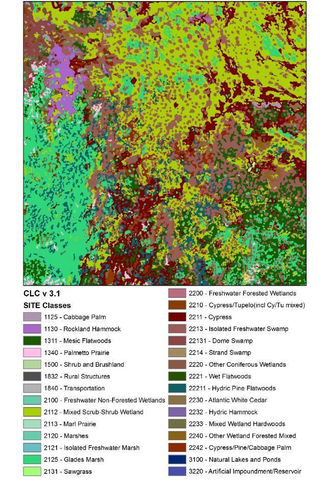
8 Cooperative Land Cover v 3.1 STATE and SITE Level Classes CLC attributes are provided at two levels: STATE and SITE STATE Appropriate for use at statewide or regional scale There are no overlaps between polygons. Often a one-to-many relationship exists between STATE and SITE level attributes. SITE Appropriate for use at local or site scale Aggregates classes hierarchically Reflects the most detailed level of the classification STATE SITE 1120 Mesic Hammock 1120 Mesic Hammock 1120 Mesic Hammock 1121 Evergreen Levee Hammock 1120 Mesic Hammock 1122 Prairie Mesic Hammock 1120 Mesic Hammock 1123 Live Oak 1120 Mesic Hammock 1124 Pine Mesic Oak 1120 Mesic Hammock 1125 Cabbage Palm
9 Land Cover Classes Classes Florida Vegetation and Land Cover 2003 Cooperative Land Cover, v 3.1 SITE Level Cooperative Land Cover, v 3.1 STATE Level Natural and Semi-natural Disturbed/Developed Water Natural Water Bodies Altered Water Bodies Total


10 Florida Veg 2003 CLC V3.1


11 Florida Veg 2003 CLC V3.1
12 Draft Priority Resources Hardwood Forested Uplands High Pine & Scrub Pine Flatwoods & Dry Prairie Freshwater Forested Wetlands Freshwater Non-Forested Wetlands Coastal Uplands Estuarine Marine Freshwater Aquatic Working Lands (WL 1, WL2)* Cultural and Socio-Economic Landscape Connectivity

13 Draft Priority Resources
14 Percent Percent of Priority Resources on Public Land

15 Percent Draft Priority Resources CLIP P1 and P
16 Hardwood Forested Uplands 481,230 acres Mesic or xeric forest dominated mainly by hardwood trees.
17 Hardwood Forested Uplands Hardwood Forested Uplands (1100) Upland Hardwood Forest ( ) Mesic Hammock ( ) Rockland Hammock ( ) Slope Forest (1140) Xeric Hammock (1150)
18 Hardwood Forested Upland - subclasses Hardwood Forested Uplands (1100) Upland Hardwood Forest ( ) Mesic Hammock ( ) Rockland Hammock ( ) Slope Forest (1140) Xeric Hammock (1150)
19 Hardwood Forested Uplands CLIP Overall 18.7 CLIP Biodiversity CLIP Landscape CLIP Water Resources
20 High Pine and Scrub 2,157,700 acres Hills with mesic or xeric woodlands or shrublands; canopy, if present, open and consisting of pine or a mixture of pine and deciduous hardwoods.
21 High Pine and Scrub High Pine and Scrub (1200) Scrub ( ) Upland Mixed Woodland (1220) Upland Coniferous ( ) Sandhill (1240)
22 High Pine & Scrub - subclassses Scrub ( ) 24.2 Upland Mixed Woodland (1220) Upland Coniferous ( ) Sandhill (1240) 27.9
23 High Pine and Scrub CLIP Overall CLIP Biodiversity CLIP Landscape 1.7 CLIP Water Resources 44.3
24 Pine Flatwoods and Dry Prairie 2,229,574 acres Mesic pine woodland or mesic shrubland on flat sandy or limestone substrates, often with a hard pan that impedes drainage.
25 Pine Flatwoods and Dry Prairie Pine Flatwoods and Dry Prairie (1300) Dry Flatwoods ( ) Pine Rockland (1320) Dry Prairie (1330) Palmetto Prairie (1340)
26 Pine Flatwoods & Dry Prairie - subclasses 1.3 Pine Flatwoods and Dry Prairie (1300) Dry Flatwoods ( ) Pine Rockland (1320) Dry Prairie (1330) Palmetto Prairie (1340) 79.8
27 Pine Flatwoods and Dry Prairie CLIP Overall CLIP Biodiversity CLIP Landscape 0.5 CLIP Water Resources
28 Coastal Uplands 103,866 acres Mesic or xeric communities restricted to barrier islands and near shore; woody or herbaceous vegetation.
29 Coastal Uplands Coastal Uplands (1600) Beach Dune (1610) Coastal Berm (1620) Coastal Grassland (1630) Coastal Strand (1640) Maritime Hammock (1650) Shell Mound (1660) Sand Beach Dry (1670)
30 Coastal Uplands - subclasses Coastal Uplands (1600) 4.0 Beach Dune (1610) Coastal Berm (1620) Coastal Grassland (1630) Coastal Strand (1640) Maritime Hammock (1650) 0.3 Shell Mound (1660) Sand Beach Dry (1670) 38.0
31 Coastal Uplands CLIP Overall CLIP Biodiversity CLIP Landscape CLIP Water Resources
32 Freshwater Forested Wetlands 7,148,984 acres Floodplain or depression wetlands dominated by hydrophytic trees.
33 Freshwater Forested Wetlands Freshwater Forested Wetlands (2200) Cypress/Tupelo ( ) Other Coniferous Wetlands ( ) Other Hardwood Wetlands ( ) Other Wetland Forested Mixed ( )
34 Forested Freshwater Wetlands - subclasses Freshwater Forested Wetlands (2200) 0.1 Cypress/Tupelo ( ) Other Coniferous Wetlands ( ) Other Hardwood Wetlands ( ) 16.5 Other Wetland Forested Mixed ( ) 28.4
35 Freshwater Forested Wetlands CLIP Overall CLIP Biodiversity CLIP Landscape 2.2 CLIP Water Resources 28.7
36 Freshwater Non-Forested Wetlands 6,019,551 acres Herbaceous or shrubby palustrine communities in floodplains or depressions; canopy trees, if present, very sparse and often stunted.
37 Freshwater Non-Forested Wetlands Freshwater Non Forested Wetlands (2100) Prairies and Bogs ( ) Marshes ( ) Marshes - species ( ) Floating Emergent Aquatic Vegetation ( ) Submergent Aquatic Vegetation (2150) Non Vegetated Wetland (2300)
38 Freshwater Non-Forested Wetlands - subclasses Freshwater Non Forested Wetlands (2100) Prairies and Bogs ( ) Marshes ( ) Marshes - species ( ) 38.6 Floating Emergent Aquatic Vegetation ( ) Submergent Aquatic Vegetation (2150) 55.1 Non Vegetated Wetland (2300)
39 Freshwater Non- Forested Wetlands CLIP Overall CLIP Biodiversity CLIP Landscape 1.6 CLIP Water Resources
40 Estuarine 3,361,510 acres Deepwater tidal habitats and adjacent tidal wetlands that are usually semienclosed by land but have open, partly obstructed, or sporadic access to the ocean, with ocean-derived water at least occasionally diluted by freshwater runoff from the land. The upstream and landward limit is where ocean-de rived salts measure less than.5 ppt during the period of 39 average annual low flow. The seaward limit is (1) an imaginary line closing the mouth of a river, bay, or sound; and (2) the seaward limit of wetland emergents, shrubs, or trees when not included in (1).
41 Estuarine Estuarine (5000) Subtidal (5100) Intertidal (5200) Exposed Limestone ( ) Tidal Flat ( ) Oyster Bar (5230) Salt Marsh (5240) Mangrove ( )
42 Estuarine - subclasses Estuarine (5000) Exposed Limestone ( ) 22.6 Tidal Flat ( ) Salt Marsh (5240) Mangrove ( )
43 Estuarine CLIP Overall 95.3 P1 P2 P3-P5 N/A CLIP Biodiversity CLIP Landscape CLIP Water Resources 89.9
44 Marine 9,635,922 acres Open ocean overlying the continental shelf and coastline exposed to waves and currents of the open ocean shoreward to (1) extreme high water of spring tides; (2) seaward limit of wetland emergents, trees, or shrubs; or (3) the seaward limit of the Estuarine System, other than vegetation. Salinities exceed 30 parts per thousand (ppt).
45 Marine 9,635,922 acres Not included in Cooperative Landcover Map. Possible subclasses: Coral reef Submerged aquatic vegetation (SAV) Hard bottom Soft bottom Mollusk Reef
46 Marine CLIP Overall CLIP Biodiversity CLIP Landscape 90.3 CLIP Water Resources
47 Freshwater Aquatic 1,567,254 acres Natural deepwater habitats and wetlands situated in a topographic depression or river channel, except those wetlands dominated by trees, shrubs, persistent emergents, emergent mosses, or lichens.
48 Freshwater Aquatic Lacustrine (3000) Natural Lakes and Ponds (3100) Limnetic ( ) Littoral (3120) Riverine (4000) Natural Rivers and Streams (4100) Alluvial Stream (4110) Blackwater Stream (4120) Spring-run Stream (4130) Seepage Stream (4140) Tidally Influenced Stream (4160)
49 Freshwater Aquatic - subclasses Lacustrine (3000) Natural Lakes and Ponds (3100) Limnetic ( ) Riverine (4000) Natural Rivers and Streams (4100) Alluvial Stream (4110) Blackwater Stream (4120) Spring-run Stream (4130) 43.1 Tidally Influenced Stream (4160)
50 0.2 Freshwater Aquatic CLIP Overall CLIP Biodiversity CLIP Landscape CLIP Water Resources
51 Working Lands 1 8,106,406 acres
52 Working Lands 1 Rural Open ( , ) Tree Plantations ( )
53 Working Lands Rural Open ( , ) Tree Plantations ( )
54 Working Lands CLIP Overall CLIP Biodiversity CLIP Landscape 33.7 CLIP Water Resources 46.6
55 Working Lands 2 5,930,619 acres
56 Working Lands 2 Agriculture (1833) Cropland/Pastureland (18331, , , ) Orchards ( ) Vineyards (18334) Specialty Farms (183352)
57 Working Lands 2 - subclasses Cropland/Pastureland (18331, , , ) Orchards ( ) 19.2 Vineyards (18334) Specialty Farms (183352) 77.5
58 0.4 Working Lands CLIP Overall 21.4 CLIP Biodiversity CLIP Landscape P1 P3 P4 P5 N/A CLIP Water Resources 46.2
59 Connectivity
60 Connectivity

61 Connectivity
62 Hardwood Forested Uplands 1100 Hardwood Forested Uplands 1110 Upland Hardwood Forest 1111 Dry Upland Hardwood Forest 1112 Mixed Hardwoods 1120 Mesic Hammock 1121 Evergreen Levee Hammock 1122 Prairie Mesic Hammock 1123 Live Oak 1124 Pine - Mesic Oak 1125 Cabbage Palm 1130 Rockland Hammock 1131 Thorn Scrub 1140 Slope Forest 1150 Xeric Hammock High Pine and Scrub 1200 High Pine and Scrub 1210 Scrub 1211 Oak Scrub 1212 Rosemary Scrub 1213 Sand Pine Scrub 1214 Coastal Scrub 1220 Upland Mixed Woodland 1230 Upland Coniferous 1231 Upland Pine 1240 Sandhill
63 Pine Flatwoods and Dry Prairie Coastal Uplands 1300 Pine Flatwoods and Dry Prairie 1310 Dry Flatwoods 1311 Mesic Flatwoods 1312 Scrubby Flatwoods 1320 Pine Rockland 1330 Dry Prairie 1340 Palmetto Prairie 1600 Coastal Uplands 1610 Beach Dune 1620 Coastal Berm 1630 Coastal Grassland 1640 Coastal Strand 1650 Maritime Hammock 1660 Shell Mound 1670 Sand Beach (Dry)
64 2200 Freshwater Forested Wetlands Freshwater Forested Wetlands 2210 Cypress/Tupelo (Cypress/Tupelo mixed) 2230 Other Hardwood Wetlands 2211 Cypress 2231 Baygall 2212 Tupelo Bay Swamp 2213 Isolated Freshwater Swamp South Florida Bayhead Dome Swamp 2232 Hydric Hammock Stringer Swamp Coastal Hydric Hammock Gum Pond Prairie Hydric Hammock Basin Swamp Cabbage Palm Hammock 2214 Strand Swamp 2233 Mixed Wetland Hardwoods 2215 Floodplain Swamp Bottomland Forest Freshwater Tidal Swamp 2332 Alluvial Forest 2220 Other Coniferous Wetlands 2234 Titi Swamp 2221 Wet Flatwoods 2240 Other Wetland Forested Mixed Hydric Pine Flatwoods 2241 Cypress/Hardwood Swamps Cutthroat Grass Flatwoods 2242 Cypress/Pine/Cabbage Palm Cabbage Palm Flatwoods Hydric Pine Savanna 2222 Pond Pine 2223 Atlantic White Cedar 2224 Slash Pine Swamp Forest
65 2100 Freshwater Non-Forested Wetlands 2110 Prairies and Bogs 2111 Wet Prairie Wiregrass Savanna Cutthroat Seep Freshwater Non- Forested Wetlands 2130 Marshes (Continued) 2131 Sawgrass 2132 Cattail 2133 Spike Rush 2134 Maidencane Calcareous Wet Prairie Pitcherplant Prairie 2112 Mixed Scrub-Shrub Wetland Shrub Bog 2113 Marl Prairie 2114 Seepage Slope 2120 Marshes 2121 Isolated Freshwater Marsh Depression Marsh Basin Marsh 2122 Coastal Interdunal Swale 2123 Floodplain Marsh Freshwater Tidal Marsh 2124 Slough Marsh 2125 Glades Marsh Keys Freshwater Marsh 2135 Dog Fennel and Low Marsh Grasses 2136 Arrowroot 2137 Giant Cutgrass 2138 Buttonbush 2139 Other spp Floating/Emergent Aquatic Vegetation 2141 Slough Pond Apple Slough 2142 Water Lettuce 2143 Spatterdock 2144 Water Hyacinth 2145 Duck Weed 2146 Water Lily 2147 Other spp Submergent Aquatic Vegetation 2300 Non-vegetated Wetland
66 Estuarine 5000 Estuarine 5100 Subtidal 5200 Intertidal 5210 Exposed Limestone 5211 Vegetated Keys Tidal Rock Barren 5212 Non-vegetated 5220 Tidal Flat 5221 Mud 5222 Sand 5230 Oyster Bar 5240 Salt Marsh 5241 Salt Flat 5242 Cordgrass 5243 Needlerush 5250 Mangrove Swamp 5251 Buttonwood Forest 5252 Scrub Mangrove
67 Freshwater Aquatic 3000 Lacustrine 3100 Natural Lakes and Ponds 3110 Limnetic 3111 Clastic Upland Lake 3112 Coastal Dune Lake 3113 Flatwoods/Prairie/Marsh Lake 3114 River Floodplain Lake/Swamp Lake 3115 Sinkhole Lake 3116 Coastal Rockland Lake 3117 Sandhill Lake 3118 Major Springs 3120 Littoral 4000 Riverine 4100 Natural Rivers and Streams 4110 Alluvial Stream 4120 Blackwater Stream 4130 Spring Run Stream 4140 Seepage Stream 4150 Calcareous Stream 4160 Tidally-influenced Stream
68 Working Lands 1 Working Lands Rural Open Rural Open Forested Oak - Cabbage Palm Forests Rural Open Pine 1833 Agriculture Cropland/Pasture Field Crops Improved Pasture Unimproved/Woodland Pasture Other Open Lands - Rural Tree Plantations Hardwood plantation Coniferous plantation Fallow Cropland Orchards/Groves Citrus Fruit Orchards Pecan Fallow Orchards Vineyard and Nurseries Specialty Farms
c Name a Name b Scrubby Flatwoods 82, Scrubby Flatwoods Pine Rockland 16, Pine Rockland 1330
 c Name a Name b 1000 1000000 1 Terrestrial - - - 1100 1100000 11 Hardwood Forested Uplands - - - 1110 1110000 111 Upland Hardwood Forest 273,406 1100000 Hardwood Forested Uplands 1111 1111000 1111 Dry
Peninsular Florida Landscape Conservation Cooperative. Marine and Estuarine Priority Resources and Conservation Targets
 Peninsular Florida Landscape Conservation Cooperative Marine and Estuarine Priority Resources and Conservation Targets Today s Webinar Overview of Peninsular Florida Landscape Conservation Cooperative
FNAI 2009 NATURAL COMMUNITY SHORT DESCRIPTIONS
 FNAI 2009 NATURAL COMMUNITY SHORT DESCRIPTIONS HARDWOOD FORESTED UPLANDS mesic or xeric forest dominated mainly by hardwood trees. Slope Forest steep slope on bluff or in sheltered ravine within the Apalachicola
Proposed Classification for Biological Assessment of Florida Inland Freshwater Wetlands
 Proposed Classification for Biological Assessment of Florida Inland Freshwater Wetlands Report to: Florida Department of Environmental Protection Contract No. WM68 (Development of a Biological Approach
Florida Land Cover Classification System *
 Florida Land Cover Classification System * Robert Kawula Jennylyn Redner Center for Spatial Analysis Fish and Wildlife Research Institute Florida Fish and Wildlife Conservation Commission Tallahassee,
1000. Marine Habitats Subtidal Rock Bottom Bedrock Rubble Unconsolidated Bottom Cobble Gravel 1123.
 1000. Marine Habitats 1100. Subtidal 1110. Rock Bottom 1111. Bedrock 1112. Rubble 1120. Unconsolidated Bottom 1121. Cobble 1122. Gravel 1123. Sand 1124. Mud 1125. Organic 1130. Aquatic Bed 1131. Rooted
Section 4. Terrestrial Habitats
 Section 4. Terrestrial Habitats Components of Reports... 1226 Definition ranking Key factors Indicators of condition Conservation actions Monitoring Terrestrial Habitat Reports... 1231 Caves, Mines, Sinkholes,
Comprehensive Wildlife Conservation Strategy for Florida Habitat Categories
 Pg 1 of 12 Comprehensive Wildlife Conservation Strategy for Florida Habitat Categories Descriptions of Vegetation and Land Cover Types Terrestrial Habitat Categories (23) 1. Scrub: This community occurs
1. GENERAL DESCRIPTION OF LAND USE / COVER TYPES (SEE GENERAL DESCRIPTIONS ON PAGE 7) A 2. ADJACENT LANDS & EASEMENTS 3. FAMILY AGRICULTURAL LEGACY
 A 2. ADJACENT LANDS & EASEMENTS 3. FAMILY AGRICULTURAL LEGACY") CONSERVATION EASEMENT PROJECT: COUNTY: NAME OF LANDOWNER: CELL/OFFICE PHONE: NAME OF FARM / SITE MANAGER: CELL/OFFICE PHONE: GENERAL DESCRIPTION OF LAND USE / COVER TYPES (SEE GENERAL DESCRIPTIONS ON PAGE
CONSERVATION EASEMENT PROJECT: COUNTY: NAME OF LANDOWNER: CELL/OFFICE PHONE: NAME OF FARM / SITE MANAGER: CELL/OFFICE PHONE: GENERAL DESCRIPTION OF LAND USE / COVER TYPES (SEE GENERAL DESCRIPTIONS ON PAGE
Components of reports Terrestrial habitat reports
 Section 4. Terrestrial Habitats Terrestrial Habitats Components of reports... 1189 Definition Ranking Key factors Indicators of condition Conservation actions Monitoring Terrestrial habitat reports...
Appendix I. Potential Adverse Change to Wetland Function Methodology and Results
 Appendix I Potential Adverse Change to Wetland Function Methodology and Results Technical Memorandum North Florida Regional Water Supply Plan Potential Adverse Change to Wetland Function January 3, 2017
3.2 Biomes and Aquatic Zones
 3.2 Biomes and Aquatic Zones Learning Goals: 1. Identify a biome based on its temperature, precipitation, and dominant plant species. 2. Identify a marine life zone based on its location and amounts of
FNAI 2010 NATURAL COMMUNITY SHORT DESCRIPTIONS
 FNAI 2010 NATURAL COMMUNITY SHORT DESCRIPTIONS HARDWOOD FORESTED UPLANDS mesic or xeric forest dominated mainly by hardwood trees. Slope Forest (G2?/S1) steep slope on bluff or in sheltered ravine within
Florida Fish and Wildlife Conservation Commission
 Florida Fish and Wildlife Conservation Commission Commissioners Brian Yablonski Chairman Tallahassee Aliese P. Liesa Priddy Vice Chairman Immokalee Ronald M. Bergeron Fort Lauderdale Richard Hanas Oviedo
Aquatic Communities Aquatic communities can be classified as freshwater
 Aquatic Communities Aquatic communities can be classified as freshwater or saltwater. The two sets of communities interact and are joined by the water cycle. Gravity eventually returns all fresh water
Surface Water and Non-Wetland Surface Waters Delineation and Classification pursuant Chapter F.A.C.
 Surface Water and Non-Wetland Surface Waters Delineation and Classification pursuant Chapter 62-340 F.A.C. What are Waters? 373.019 F.S. Definitions (20) Water or waters in the state means any and all
Resource Protection Areas: Nontidal Wetlands Guidance on the Chesapeake Bay Preservation Area Designation and Management Regulations June 18, 2007
 Resource Protection Areas: Nontidal Wetlands Guidance on the Chesapeake Bay Preservation Area Designation and Management Regulations June 18, 2007 Purpose: This document provides guidance on requirements
Production of the Missouri Land Cover Data Layer Brief Notes 1/00 DRAFT
 Production of the Missouri Land Cover Data Layer Brief Notes 1/00 DRAFT This land cover data layer was derived from Thematic Mapper (TM) satellite data from 1991, 1992, and 1993 (listed below). For most
A GUIDE TO THE WETLAND, DEEPWATER HABITATS, AND RIPARIAN CLASSIFICATIONS USED IN WETLAND AND RIPARIAN MAPPING IN MONTANA
 A GUIDE TO THE WETLAND, DEEPWATER HABITATS, AND RIPARIAN CLASSIFICATIONS USED IN WETLAND AND RIPARIAN MAPPING IN MONTANA Purpose: The Montana Natural Heritage Program s Wetland and Riparian Mapping Center
Ch. 7 Aquatic Ecology
 Ch. 7 Aquatic Ecology 1.Coral Reefs: the aquatic equal to the tropical rain forests 2.The two major aquatic life zones A. saltwater or marine (estuaries, coastlines, coral reefs, coastal marshes, mangrove
2015 Wildlife Action Plan Habitats Crosswalk
 2015 Wildlife Action Plan Habitats Crosswalk A crosswalk guide between Wildlife Action Plan Habitats and other habitat classification schemes. Ecosystem Comments NH WAP 2015 NHNHB System Open Water (NLCD-NHD
Think About It (not on notes)
") Aquatic Ecosystems Think About It (not on notes) We call our planet Earth, yet nearly three-fourths of Earth s surface is covered with water. Despite the vital roles aquatic ecosystems play in the biosphere,
Aquatic Ecosystems Think About It (not on notes) We call our planet Earth, yet nearly three-fourths of Earth s surface is covered with water. Despite the vital roles aquatic ecosystems play in the biosphere,
What are Wetlands? Wetland Ecology Fall 2017
 What are Wetlands? Wetland Ecology Fall 2017 Ingredients to make a wetland Water Topography Soil Plants Animals Definitions Transition zone between upland and permanently flooded ecosystems Isolated basins
Chapter 6. Aquatic Biodiversity. Chapter Overview Questions
 Chapter 6 Aquatic Biodiversity Chapter Overview Questions Ø What are the basic types of aquatic life zones and what factors influence the kinds of life they contain? Ø What are the major types of saltwater
Wetland name or number 2
 H. Does the wetland unit have the opportunity to provide habitat for many species? H.1 Buffers (see P. 80) Choose the description that best represents condition of buffer of wetland unit. The highest scoring
Saving Wetlands. Is saving Lives
 Saving Wetlands Is saving Lives What are Wetlands? areas between water and land What are Wetlands? contain hydric soil - saturated by water. soil lacks oxygen when saturated land that is seasonally wet.
Legal Perspectives on Florida Wetland Jurisdiction
 Legal Perspectives on Florida Wetland Jurisdiction Timothy J. Perry, Esq. Oertel, Fernandez, Bryant & Atkinson, P.A. Tallahassee, Florida tperry@ohfc.com History 1993 Florida Environmental Reorganization
Freshwater ecosystems
 Aquatic Ecosystems Aquatic Ecosystems The types of organisms in an aquatic ecosystem are determined by the water s salinity. Salinity - Amount of salt in the water. Freshwater ecosystems do not have any
Designing Sustainable Landscapes: DSLland and Subsysland
 Designing Sustainable Landscapes: DSLland and Subsysland A project of the University of Massachusetts Landscape Ecology Lab Principals: Kevin McGarigal, Professor Brad Compton, Research Associate Ethan
AP Environmental Science
 AP Environmental Science Types of aquatic life zones MARINE Estuaries coral reefs mangrove swamps neritic zone pelagic zone FRESHWATER lakes and ponds streams and rivers wetlands Distribution of aquatic
Places of interest as you travel to the SESAF Annual Conference at the Sandestin Hilton.
 Places of interest as you travel to the SESAF Annual Conference at the Sandestin Hilton. Topsail Hill Preserve State Park is right next door to the Sanddestin Hilton. The park features pristine beaches,
Restoration = return of a wetland from a disturbed or altered condition caused by human activity to a previously existing condition
 Wetland Ecology Lectures 21-22 Creation & Restoration Two general starting points Learn & understand wetland science & its principle first Broaden your horizons beyond the field you were trained in so
Lesson Overview 4.5 Aquatic Ecosystems
 Lesson Overview 4.5 Conditions Underwater What factors affect life in aquatic ecosystems? Aquatic organisms are affected primarily by the water s depth, temperature, flow, and amount of dissolved nutrients.
Climate: describes the average condition, including temperature and precipitation, over long periods in a given area
 Ch. 6 - Biomes Section 6.1: Defining Biomes Biome: a group of ecosystems that share similar biotic and abiotic conditions, large region characterized by a specific type of climate, plants, and animals
GLOSSARY. Algal Bed - A marine and estuarine natural community dominated by various species of algae attached to the bottom.
 GLOSSARY Accessory Apartment - A separate living unit, within a principal structure, that may have separate bathroom and cooking facilities, but which is clearly accessory to the principal use. Advance
Science Plan. Executive Summary. Introduction
 Science Plan Executive Summary This Science Plan will establish and define the focus of the Peninsular Florida Landscape Conservation Cooperative (PFLCC) science investments. The data and products derived
Legal Perspectives on Florida Wetland Jurisdiction
 Legal Perspectives on Florida Wetland Jurisdiction Timothy J. Perry, Esq. Oertel, Fernandez, Bryant & Atkinson, P.A. Tallahassee, Florida tperry@ohfc.com History 1993 Florida Environmental Reorganization
What factors affect life in aquatic ecosystems?
 Aquatic Ecosystems: Notes Outline Today s Objective: Students will explain that different types of organisms exist within aquatic systems due to chemistry, geography, light, depth, salinity, and/or temperature.
Chapter 05 Lecture Outline
 Chapter 05 Lecture Outline William P. Cunningham University of Minnesota Mary Ann Cunningham Vassar College Copyright The McGraw-Hill Companies, Inc. Permission required for reproduction or display. 1
Vegetative Dynamic Modeling for the SAMBI DSL Project
 Vegetative Dynamic Modeling for the SAMBI DSL Project dd S. Earnhardt Biodiversity and Spatial Information Center, NC University, Raleigh, NC 27695 INTRODUCTION In the Southeastern U.S. rapid urbanization,
Aquatic Biome. Book. Saltwater Marsh. Anthropogenic Influence. Examples. Producers Consumers Abiotic Factors
 Aquatic Biome Use the provided pieces to complete this book. Glue the appropriate pieces for each biome into the book. Use the internet to help you. Book Saltwater Marsh Freshwater Marsh Bog Lakes and
Teacher s Guide. Southern Coastal Watershed Excursion. View excursions at: WaterMatters.org/Watersheds
 Teacher s Guide View excursions at: WaterMatters.org/Watersheds Lesson Time: One block or class period (approximately 50 minutes) Grades: 9 12 Objective: Using context clues and relevant facts in the excursion,
Hydrogeomorphic Wetland Classification HGM classification for wetlands of the Mid-Atlantic Region, USA
 Hydrogeomorphic Wetland Classification HGM classification for wetlands of the Mid-Atlantic Region, USA Robert P. Brooks Riparia, Department of Geography PENNSYLVANIA STATE UNIVERSITY PLEASE READ BEFORE
Ecology and Conservation of California's Coastal Freshwater Wetlands An Introduciton to the diversity of coastal freshwater wetlands Lorraine Parsons
 California s Coastal Freshwater Wetlands Lorraine Parsons Point Reyes Station, Calif. Habitat Definition Holland - e.g., Coastal and Valley Freshwater Marsh Cowardin Classification Wetlands are lands transitional
Slide 1. Earth Science. Chapter 11 Living Systems
 Slide 1 Earth Science Chapter 11 Living Systems Slide 2 Biomes A biome is a region with a certain climate and certain forms of vegetation. It is mostly the climate temperature and precipitation in an area
Chapter 4, sec. 1 Prentice Hall Biology Book p (This material is similar to Ch.17, sec.3 in our book)
") Chapter 4, sec. 1 Prentice Hall Biology Book p.87-89 (This material is similar to Ch.17, sec.3 in our book) Term Definition Weather Day-to-day condition of earth s atmosphere at a particular time and place
Chapter 4, sec. 1 Prentice Hall Biology Book p.87-89 (This material is similar to Ch.17, sec.3 in our book) Term Definition Weather Day-to-day condition of earth s atmosphere at a particular time and place
Activity--Any project and such other human action within the river area which is regulated or permitted by the Department of Natural Resources.
 GLOSSARY Activity--Any project and such other human action within the river area which is regulated or permitted by the Department of Natural Resources. Aesthetic Values--Scenic characteristics or amenities
biology Slide 1 of 39 End Show Copyright Pearson Prentice Hall
 biology 1 of 39 2 of 39 4-4 Aquatic Ecosystems Nearly three-fourths of the Earth s surface is covered with water. Almost all bodies of water contain a wide variety of communities governed by biotic and
4-4 Aquatic Ecosystems
 biology 1 of 39 2 of 39 Nearly three-fourths of the Earth s surface is covered with water. Almost all bodies of water contain a wide variety of communities governed by biotic and abiotic factors including
Analysis of the Vulnerability of Southeast Florida to Sea Level Rise
 Analysis of the Vulnerability of Southeast Florida to Sea Level Rise South Florida Regional Climate Change Compact Mapping and Vulnerability Assessment Work Group April, 2011 Contents Vulnerability to
River Talk Patterns. Student Copy Page PART I (1 of 1) 3. Human nervous system. Waters and drainage patterns. Road system.
 3. Human nervous system. Waters and drainage patterns. Road system.") River Talk Patterns Student Copy Page PART I (1 of 1) 3 Human nervous system photo credit: Hemera Thinkstock Photos Waters and drainage patterns photo credit: Comstock Getty Images Road system photo credit:
River Talk Patterns Student Copy Page PART I (1 of 1) 3 Human nervous system photo credit: Hemera Thinkstock Photos Waters and drainage patterns photo credit: Comstock Getty Images Road system photo credit:
SNC1D BIOLOGY 5/10/2013. SUSTAINABLE ECOSYSTEMS L Biomes (P.16-17) Biomes. Biomes
 Biomes. Biomes") SNC1D BIOLOGY SUSTAINABLE ECOSYSTEMS L Biomes (P.16-17) Biomes Areas of the world that have a similar climate and similar organisms are known as biomes. Desert, coral reef, tundra, and tropical rainforest
SNC1D BIOLOGY SUSTAINABLE ECOSYSTEMS L Biomes (P.16-17) Biomes Areas of the world that have a similar climate and similar organisms are known as biomes. Desert, coral reef, tundra, and tropical rainforest
PASCO COUNTY BOCC ENVIRONMENTAL LANDS ACQUISITION AND MANAGEMENT PROGRAM (ELAMP) David Curry Living Trust Property
 David Curry Living Trust Property") PASCO COUNTY BOCC ENVIRONMENTAL LANDS ACQUISITION AND MANAGEMENT PROGRAM (ELAMP) David Curry Living Trust Property Produced by: Ryan Long- Biologist I Tammy Odierna- Land Acquisition Coordinator Abstract:
PASCO COUNTY BOCC ENVIRONMENTAL LANDS ACQUISITION AND MANAGEMENT PROGRAM (ELAMP) David Curry Living Trust Property Produced by: Ryan Long- Biologist I Tammy Odierna- Land Acquisition Coordinator Abstract:
 SOUTHEAST GAP ANALYSIS PROJECT ANCILLARY DATA DEVELOPMENT AND USE IN PREDICTED DISTRIBUTION MODELING www.basic.ncsu.edu/segap INTRODUCTION.. 3 LAND COVER / LAND USE... 4 Development... 4 Usage in Modeling.....
Chapter 3: Communities, Biomes, and Ecosystems
 Chapter 3: Communities, Biomes, and Ecosystems How would you describe your Community? Did you include your family and friends? Did you include your school? Did you include plants and animals? A biological
Oslo, September. Brendan Freeman. UK Office for National Statistics
 22 nd Meeting of the London Group on Environmental Accounting Oslo, 28-30 September CARBON ACCOUNTING IN THE UK: AN OVERVIEW OF PROGRESS AND ISSUES Brendan Freeman UK Office for National Statistics Introduction
Carpenter House (Site 447)
") Carpenter House (Site 447) The Carpenter House (Hollywood North Beach Addition/Site 447) is located on North Surf Road, east of North State Road A1A between Cody Street and Greene Street in the City of
Carpenter House (Site 447) The Carpenter House (Hollywood North Beach Addition/Site 447) is located on North Surf Road, east of North State Road A1A between Cody Street and Greene Street in the City of
6 TH. Most of the Earth Is Covered with Water (2) Most Aquatic Species Live in Top, Middle, or Bottom Layers of Water (1)
 Most Aquatic Species Live in Top, Middle, or Bottom Layers of Water (1)") A Healthy Coral Reef in the Red Sea MILLER/SPOOLMAN ESSENTIALS OF ECOLOGY 6 TH Chapter 8 Aquatic Biodiversity Fig. 8 1, p. 168 Most of the Earth Is Covered with Water (2) Aquatic life zones Saltwater life
A Healthy Coral Reef in the Red Sea MILLER/SPOOLMAN ESSENTIALS OF ECOLOGY 6 TH Chapter 8 Aquatic Biodiversity Fig. 8 1, p. 168 Most of the Earth Is Covered with Water (2) Aquatic life zones Saltwater life
Country fact sheet. Land cover Malta. September Photo: Toni García, My City/EEA
 Country fact sheet Land cover 2012 Malta September 2017 Photo: Toni García, My City/EEA Land cover 2012 Overview of land cover & change Concerning the land cover development, there occurs no significant
Appendix 6.1 SWG Presentation (early version)
") Appendix 6.1 SWG Presentation (early version) Presented on these occasions: organizational meeting of CWCS partner agencies and NGOs, including biologists and academics Central Arkansas Audubon (during
Appendix 6.1 SWG Presentation (early version) Presented on these occasions: organizational meeting of CWCS partner agencies and NGOs, including biologists and academics Central Arkansas Audubon (during
Performance Measures and Habitat Units
 Performance Measures and Habitat Units Andrew LoSchiavo, U.S. Army Corps of Engineers One of the Last Old Growth Cypress Floodplains in the SE Florida Last Large Freshwater Wetland Corridor in Project
Maps to Help You Protect and Manage Lands: The Revised Wildlife Action Plan Maps. Emily Preston, Wildlife Biologist Katie Callahan, GIS specialist
 Maps to Help You Protect and Manage Lands: The Revised Wildlife Action Plan Maps Emily Preston, Wildlife Biologist Katie Callahan, GIS specialist What is the Wildlife Action Plan? Restore rare wildlife
Exploring the Ecosystems of Eastern North Carolina
 Alignment to NC Essential Standards Science 4.L.1, 5.L.2 Social Studies 4.G.1, 5.G.1, 5.G.1.2 Language Arts RI.5.1, RI.5.4, RI.5.7, W.5.7, W.5.10 Learning Objectives Students will describe and compare
Northern Painted Turtle Chrysemys picta
 Northern Painted Turtle Chrysemys picta Taxa: Reptilian Order: Cryptodeira Family: Emydidae KNOWN RANGE: SE-GAP Spp Code: ITIS Species Code: 173783 NatureServe Element Code: ARAAD11 PREDICTED HABITAT:
Chapter 5 Biomes and Biodiversity. Copyright The McGraw-Hill Companies, Inc. Permission required for reproduction or display.
 Chapter 5 Biomes and Biodiversity Copyright The McGraw-Hill Companies, Inc. Permission required for reproduction or display. In the end, we conserve only what we love. We will love only what we understand.
VEGETATIVE, WATER, FISH AND WILDLIFE RESOURCES POLICIES
 VEGETATIVE, WATER, FISH AND WILDLIFE RESOURCES POLICIES The County will: GOALS AND OBJECTIVES 1.1 Conserve, Enhance, Protect, Maintain and Manage Vegetative, Water, Fish and Wildlife Resources Promote
Country fact sheet. Land cover Liechtenstein. September Photo: Toni García, My City/EEA
 Country fact sheet Land cover 2012 Liechtenstein September 2017 Photo: Toni García, My City/EEA Land cover 2012 Overview of land cover & change As in previous periods, the land cover development in the
Country fact sheet. Land cover Switzerland. September Photo: Toni García, My City/EEA
 Country fact sheet Land cover 2012 Switzerland September 2017 Photo: Toni García, My City/EEA Land cover 2012 Overview of land cover & change In the long term, the Swiss landscape shows very low intensity
U.S. Army Corps of Engineers Mobile District
 U.S. Army Corps of Engineers Mobile District General Permit for Living Shorelines in Alabama Sandy P. Gibson Regulatory Specialist, Coastal Alabama Regulatory Division, Mobile District US Army Corps of
Country fact sheet. Land cover Luxembourg. September Photo: Toni García, My City/EEA
 Country fact sheet Land cover 2012 Luxembourg September 2017 Photo: Toni García, My City/EEA Land cover 2012 Overview of land cover & change The small country of Luxembourg shows significant decrease of
Striped Skunk Mephitis mephitis
 Striped Skunk Mephitis mephitis Taxa: Mammalian Order: Carnivora Family: Mephitidae KNOWN RANGE: SE-GAP Spp Code: ITIS Species Code: 18562 NatureServe Element Code: AMAJF61 PREDICTED HABITAT: P:\Proj1\SEGap
Gas Guzzlers. Biological Pump
 Gas Guzzlers Biological Pump Aquatic Biodiversity Chapter 8 Coral Reefs Open Ocean Deep Sea Marine equivalent of tropical rain forests Habitats for one-fourth of all marine species Coral polyps, which
Country fact sheet. Land cover Cyprus. September Photo: Toni García, My City/EEA
 Country fact sheet Land cover 2012 Cyprus September 2017 Photo: Toni García, My City/EEA Land cover 2012 Overview of land cover & change In the period, there has been observed significant decrease of intensity
FLORIDA VEGETATION 2003 AND LAND USE CHANGE BETWEEN AND 2003
 Agricultural and Natural Resource Sciences FLORIDA VEGETATION 2003 AND LAND USE CHANGE BETWEEN 1985 89 AND 2003 RANDY KAUTZ 1,BETH STYS, AND ROBERT KAWULA Florida Fish and Wildlife Conservation Commission,
Silvicultural practices in the restoration of degraded ecosystems
 Silvicultural practices in the restoration of degraded ecosystems Current conditions reflect site history and physical environment Altered fire regimes, including exclusion Forest management, including
IFAS Assessment of Non-Native Plants in Florida s Natural Areas Status Assessment 1
 Revised April 2008 IFAS Assessment of Non-Native Plants in Florida s Natural Areas Status Assessment 1 Authors: Alison M. Fox, Doria R. Gordon, Joan A. Dusky, Linda Tyson, and Randall K. Stocker 2 Footnotes:
Government of Uganda prepared research document which is "National Biomass Study on Class of land cover and land use in Uganda is as follows;
 State of baselines Government of Uganda prepared research document which is "National Biomass Study on 2002. Class of land cover and land use in Uganda is as follows; Table 3-1 Stratification System Class
Changes in the FGDC Wetland Classification Standard Cowardin 2.0
 Changes in the FGDC Wetland Classification Standard Cowardin 2.0 Rusty Griffin National Coordinator for Quality Assurance and Consistency USFWS National Standards and Support Team Madison, WI Wetland Mapping
Mosquito Hill Biotic Inventory Data Sheets feet radius circle (1/100 th of a Hectare)
") Observers (first and last names) Mosquito Hill Biotic Inventory Data Sheets School Name Date (day, month, year) Site Number Size of Area being Assessed Start Time Stop Time Air Temperature ( o F or o C)
Observers (first and last names) Mosquito Hill Biotic Inventory Data Sheets School Name Date (day, month, year) Site Number Size of Area being Assessed Start Time Stop Time Air Temperature ( o F or o C)
Bosnia and Herzegovina
 Country fact sheet Land cover 2012 Bosnia and Herzegovina September 2017 Photo: Toni García, My City/EEA Land cover 2012 Overview of land cover & change The overall pace of land cover development in Bosnia
1.1 Registered property owner 1.2 Plan author information. Roll number (19 digits) Property description Area (municipality, lot, concession)
 Property description Area (municipality, lot, concession)") Stewardship plan This stewardship plan is for the 20-year period from with activities described for the 10-year period from Jan. 1, 2002 to Dec. 31, 2021 Jan. 1, 2002 to Dec. 31, 2011 Section 1: Property
Stewardship plan This stewardship plan is for the 20-year period from with activities described for the 10-year period from Jan. 1, 2002 to Dec. 31, 2021 Jan. 1, 2002 to Dec. 31, 2011 Section 1: Property
WETLANDS. Presented By: Cara Abbott Program Manager / Education and Outreach Coordinator for The Institute for Regional Conservation
 WETLANDS Presented By: Cara Abbott Program Manager / Education and Outreach Coordinator for The Institute for Regional Conservation OUTLINE 1. Wetlands Defined 2. Properties of Wetlands 3. Societal Value
Chapter 5 AQUATIC BIOMES
 Chapter 5 AQUATIC BIOMES 1 OUTLINE Marine Ecosystems Coasts - Sandy, Rocky, Salt Marsh, Mangrove Coral Reefs Open Ocean Hydrothermal Vents Freshwater Ecosystems - Lakes, Rivers, Wetlands Human Disturbance
Country fact sheet. Land cover Bulgaria. September Photo: Toni García, My City/EEA
 Country fact sheet Land cover 2012 Bulgaria September 2017 Photo: Toni García, My City/EEA Land cover 2012 Overview of land cover & change The overall change rate in Bulgaria is very low, compared to other
Country fact sheet. Land cover Romania. September Photo: Toni García, My City/EEA
 Country fact sheet Land cover 2012 Romania September 2017 Photo: Toni García, My City/EEA Land cover 2012 Overview of land cover & change The Romanian landscape is characterised by its low dynamics of
Land use in Hardee County : prepared by Center for Economic Development Research, College of Business Administration, University of South Florida
 University of South Florida Scholar Commons College of Business Publications College of Business 2-1-2003 Land use in Hardee County : prepared by Center for Economic Development Research, College of Business
 Good Morning! Bruce Gilman Department of Environmental Conservation and Horticulture Finger Lakes Community College 3325 Marvin Sands Drive Canandaigua, New York 14424 585-785- 1255 gilmanba@flcc.edu Northern
Country fact sheet. Land cover Finland. September Photo: Toni García, My City/EEA
 Country fact sheet Land cover 2012 Finland September 2017 Photo: Toni García, My City/EEA Land cover 2012 Overview of land cover & change The land cover development in Finland has similar intensity and
Country fact sheet. Land cover Austria. September Photo: Toni García, My City/EEA
 Country fact sheet Land cover 2012 Austria September 2017 Photo: Toni García, My City/EEA Land cover 2012 Overview of land cover & change 2006-2012 Despite its significant acceleration, compared to the
The Parker River Watershed: An Assessment of Recent Trends in Salt Marshes, Their Buffers, and River-Stream Buffer Zones ( )
") U.S. Fish and Wildlife Service. The Parker River Watershed: An Assessment of Recent Trends in Salt Marshes, Their Buffers, and River-Stream Buffer Zones (1985-1999) National Wetlands Inventory Northeast
U.S. Fish and Wildlife Service. The Parker River Watershed: An Assessment of Recent Trends in Salt Marshes, Their Buffers, and River-Stream Buffer Zones (1985-1999) National Wetlands Inventory Northeast
Chapter - 4 WETLAND CLASSIFICATION
 Chapter - 4 WETLAND CLASSIFICATION 4.1. GENERAL CLASSIFICATION The primary goal of wetland classification, according to Cowardin et.al (1979) is to impose boundaries on natural ecosystems for the purpose
Country fact sheet. Land cover Norway. September Photo: Toni García, My City/EEA
 Country fact sheet Land cover 2012 Norway September 2017 Photo: Toni García, My City/EEA Land cover 2012 Overview of land cover & change The Norwegian landscape is characterized by very low intensity of
1 Introduction. 1.1 What is a wetland?
 1 Introduction 1.1 What is a wetland? All around the world ( Fig. 1.1 ) there are places with shallow water or saturated soils whose vegetation is dominated by species of plants that are found nowhere
We must protect aquatic life zones from the pollutants, water controls, and deterioration that we press upon them every day.
 Chapter 8 Aquatic Biodiversity Summary 1. The basic types of aquatic life zones are the surface, middle, and bottom layers. The life in aquatic life zones is influenced by temperature, access to sunlight
Country fact sheet. Land cover Denmark. September Photo: Toni García, My City/EEA
 Country fact sheet Land cover 2012 Denmark September 2017 Photo: Toni García, My City/EEA Land cover 2012 Overview of land cover & change The overall land cover change rate in Denmark, which has been below
Land Cover / Land Use & Digital Elevation Maps. These are required for almost all coastal products involving the terrestrial side.
 Land Cover / Land Use & Digital Elevation Maps These are required for almost all coastal products involving the terrestrial side. Example Issues to be Addressed Risk and vulnerability assessment Urbanization
GUIDE TO THE NATURAL COMMUNITIES OF NORTH CAROLINA FOURTH APPROXIMATION. March 2012
 GUIDE TO THE NATURAL COMMUNITIES OF NORTH CAROLINA FOURTH APPROXIMATION March 2012 Michael P. Schafale North Carolina Natural Heritage Program Department of Environment and Natural Resources Table of Contents
Southern Finland regional analysis
 Southern Finland regional analysis Background for the exercise Training example and data created originally for training of regional council of Southern Finland 2013 Aims at presenting a realitic, yet
Country fact sheet. Land cover Albania. September Photo: Toni García, My City/EEA
 Country fact sheet Land cover 2012 Albania September 2017 Photo: Toni García, My City/EEA Land cover 2012 Overview of land cover & change With an annual land cover change rate of 0.1, the overall pace