BALTIC OPERATIONAL OCEANOGRAPHIC SYSTEM BOOS
|
|
|
- Spencer Horace Craig
- 6 years ago
- Views:
Transcription
1 BALTIC OPERATIONAL OCEANOGRAPHIC SYSTEM BOOS E. Buch, J. Elken, J. Gajewski, B. Haakansson, K. Kahma and K. Soetje BOOS Steering Group, Copenhagen, Denmark Abstract BOOS is a formal association of institutes from Sweden, Finland, Russia, Estonia, Latvia, Lithuania, Poland, Germany and Denmark taking national responsibility for operational oceanographic services, which shall support the protection of lives and properties and the promotion of the development of society. Operational oceanography includes the routine collection, interpretation and presentation of data from the ocean and atmosphere to: give a reliable description of the actual conditions of the sea including its living resources provide prognoses for the future development of the conditions in the sea establish a marine database from which time series and statistical analysis can be obtained for descriptions of trends and changes in the marine environment, including consequences for the living conditions in, on and around the sea. BOOS focuses primarily on observations, analysis and model predictions for water level, waves, currents, temperature, salinity, sea ice, oxygen, nutrients, algae, and chlorophyll, and contributes thereby to improve efficiency of marine operations, reduce the risk of accidents, optimise the monitoring of the marine environment and climate, improve the assessment of fish stocks and improve the foundation of public marine management. Developments of new products and services are implemented through projects. At present the BOOS members are working closely together in the EU financed project PAPA, which will in a cost-effective manner integrate and further develop the present operational ocean monitoring, data management and modelling activities within the Baltic Sea with the purpose of producing data products and ocean forecasts of a higher quality to the benefit of the users. PAPA is considered by the partners to constitute a valuable advance towards the establishment of an effective operational oceanographic service for the Baltic Sea. 1. Present activities of BOOS The driving force in operational oceanography is the needs and requests from users of operational oceanographic services and products. It is therefore vitally important to have a good, open and positive running dialog with all potential users. The most important marine related areas which require operational oceanographic services in the Baltic are: Shipping - all kinds; Navigation in shallow areas and entrances to harbours; Rescue operations, drift forecasting; Military purposes; Storm surge warnings; Flood protection; Coastal protection; Transport calculations of water, substances and passive biological material, e.g. algae and fish eggs; Bottom water renewal, oxygenation; Environmental protection, impact assessment and management; Ecosystem assessment; Fisheries planning and management; Recreation purposes; Public warnings; Research. The production line in generating operational oceanographic services is: Observations Data Exchange Analysis Model Forecasts Verificatio Dissemination of products and services USERS User requests

2 BOOS is based on existing national observation programmes, which already are very extensive, but can be made more operational. At present the physical oceanographic observations such as water level, temperature, salinity, waves, currents, sea ice are the most operational in the sense that real-time or near real-time data delivery is implemented by most BOOS member organisations. BOOS is therefore in its present stage of development primarily focussing on the production of services related to physical parameters. One of the most important subject to address in order to create a operational oceanographic system is the establishment of an effective data exchange system. BOOS has built a simple but effective FTPbox system to exchange data. Members of the BOOS co-operation exchange data using a system of ftp-boxes. Each member institution puts the data, it wants to exchange with the other members, in its own ftp box, where it can be collected by the other partners. The system is protected by usernames and passwords The experience of BOOS is however that the most severe problem in establishing a data exchange system has not been the technical set-up but institutional and national rules and regulation regarding exchange and release of data. All the legal aspects concerning the data exchange i.e. the right to use data for institutional and commercial purposes is addressed with great care in the EuroGOOS data policy, which the members have agreed to follow. Despite of this agreement it is still not easy and takes some time for the individual BOOS members to achieve the necessary permissions to exchange their data in real-time. Several physical models are run in an operational mode by BOOS members forecasting water level, waves, temperature and salinity fields, currents, transports through sections, sea ice, drift patterns for various substances (oil, chemicals) and objects. Ecological models are in the development phase at several BOOS member institutions and some of these are at present run in a pre-operational mode. Taking into consideration the complexity of the marine ecosystems, including both processes and variability in time and space, it is part of the BOOS strategy that coupled 3 dimensional biogeochemical ocean models, should be part of a system for making an integrated assessment of environmental information available. Such a model system will be an important tool for planning and decision, e.g. within: environmental status in different areas; assessment of the spatial influence of polluting activities; calculating source apportionment from different areas; forecasts of pollutants (spatial and temporal) when the load is changed (floods, reduction scenarios); improved basis for causal relationships, e.g. algae blooms and oxygen deficiencies; monitoring and forecasting of the environmental now situation.

3 Oil drift Sea Ice distribution
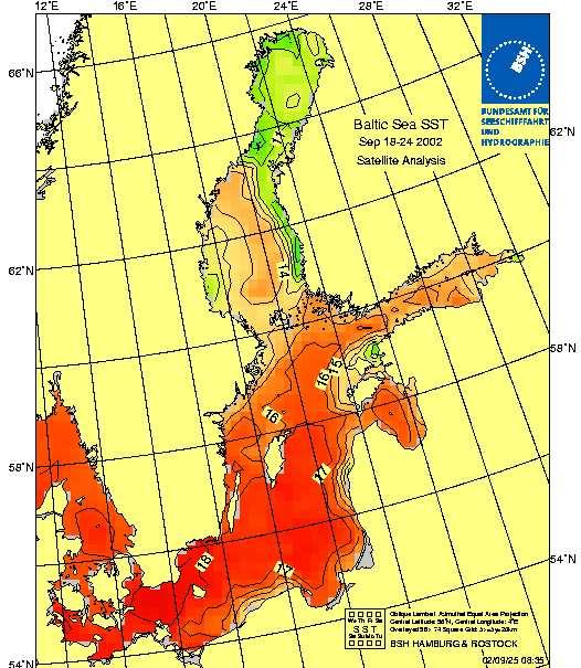
4 Dissemination of the operational products and services are a crucial task which BOOS handles on different levels. BOOS has its own web page where real-time observations of water level and waves are displayed as well as weekly maps of SST. From the BOOS page there are links to the web page of the BOOS members, where additional products can be found such as prognoses for various parameters displayed either for the entire Baltic Sea or for national waters only. Additionally the individual BOOS members may deliver special products to specific users/costumers. 2. Projects The development of BOOS is done through projects and the BOOS members are at present working on the following projects: PAPA; Data exchange and homepage; Sea Surface Temperature; Transports; Waves; Optimising Baltic-sea Observational Networks (OBON); Baltic Sea Water Level Project; Harmful algae blooms project (HABWARN); Zooplankton. Detailed project descriptions are given in the Annex. 3. Summary The vision of BOOS is to provide an integrated service to marine users and policy makers in support of safe and efficient off-shore activities, environmental management, security, and sustainable use of marine resources. BOOS aims to develop a single system for operational monitoring and forecasting of the Baltic Sea and a co-ordinated network of coastal systems. The systems will merge and assimilate diverse data from space-borne sensors and in situ measurement networks in order to monitor the Baltic Sea physics, biogeochemistry and ecosystems and to provide forecasts on prediction time scales ranging from days to months. BOOS will develop and service marine applications which address the needs of both intermediate and end-users, whether institutional or from the private sector. Appendix BOOS Projects PAPA The PAPA project is sponsored under EU s 5 th Framework Thematic Network programme and will start November 1, PAPA will in a costeffective manner integrate and further develop the present operational ocean monitoring, data management and modelling activities within the Baltic Sea with the purpose of producing data products and ocean forecasts of a higher quality to the benefit of the users. PAPA is considered by the partners to constitute a valuable advance towards the establishment of an effective operational oceanographic service for the Baltic Sea. Examples of products and services generated BOOS and its member organisations. The objectives of PAPA is to: build the basin-wide network for ocean monitoring and forecasting, linking all the Baltic countries, broadening and strengthening the existing network of national institutions already established by PAPA partners; identify the gaps in the monitoring systems in the region and in the capability to measure, model and forecast the ecosystem, taking stock of current RTD projects and of the EuroGOOS and BOOS activities; build capacities for expertise in the setting up and running of observing platforms, in managing data, in modelling and forecasting the ecosystem; design an effective observing and forecasting system, inter-comparing experiences and standardising practices, towards the coordinated upgrading of the observing and forecasting capabilities in all Baltic countries; raise awareness on the benefits of ocean forecasting at local, regional and global scales, involving stakeholders and disseminate PAPA results and products. DATA EXCHANGE AND HOMEPAGE The objectives is design an information system that can: deliver a platform for operational interagency data exchange; deliver a platform for operational common product development including automatic production of value added oceanographic information; prepare platform for operational delivery of user-oriented products to the marine related society; All of the listed tasks are essential to: Improving services to the users Increasing quality of the products by better utilisation of existing data Providing more user-oriented products by means of more user-friendly product and data dissemination Decreasing production costs by sharing the workload
5 SEA SURFACE TEMPERATURES The SST charts that are presently produced for the Baltic Sea are based on satellite data or a combination of satellite data and in situ measurements. The frequency at which these maps are produced is about 1-2 times a week. The situation today is characterized by the following shortcomings: Sparse data coverage; Highly non-uniform data coverage; Various frequencies at which observations are made; Various data format; Manually processed data in many cases. The aim of the project is to produce daily charts of sea surface temperature in the Baltic. To meet this goal a collaboration of the Baltic States is necessary since more real time data need to be available in order to improve the SST charts. The new product will be based on in situ as well as satellite data of sea surface temperature. Ice conditions will also be taken into account. An optimization of the SST algorithm used for satellite data will be carried out. All data will, furthermore, be subjected to an automatic quality control. The SST charts will be produced using the BSH system which is presently applied for the North Sea. TRANSPORTS Knowledge of the volume transports in and out of the Baltic Sea as well as between the open Baltic Sea and regional areas (bays, fjords) are essential to monitor and quantify transports of dissolved substances (nutrients, harmful chemicals), passive biological material (algae, fish eggs) etc. Using well calibrated 3D ocean models together with in situ observation on strategic localities for assimilation and verification purposes it is possible calculate the transports in and out of enclosed areas or through predefined sections. WAVES The size shape and coastline structure of the Baltic Sea makes the wave properties different from those in open ocean. Even so, in the area where the wave climate is most severe the waves in the Baltic Sea are high enough to be important for the safety at seas. Sea and swell play also significant role in the air-sea interaction processes (including gas exchange), surface layer mixing, surface drift (Stokes drift) and sediment erosion. The are several operational wave models run by the BOOS members. A coupled atmosphere-wave (HIRLAM-WAM) model has been operational in Finland since September The purpose of the wave project is to combine all wave forecasts of the partners. Together with the coupling project wave project has the following objectives: Plan and prepare a general coupling interface between atmospheric and ocean models; Plan and prepare a general interface between Baltic Sea models and local (coastal area) operational models; Make arrangements for real time data exhange for open boundaries in co-operation with the EuroGOOS North-West Shelf Task Team; Plan and prepare for introducing data assimilation; consider new aspects as a result of coupling. OPTIMISING BALTIC-SEA OBSERVATIONAL NETWORKS (OBON) Existing Baltic Sea observing networks contain local/regional systems from major marine and environmental institutes of Baltic countries (mostly BOOS members). Monitoring activities are designed in ad hoc and in an uncoordinated way. Technology used has not been optimised for basin-scale sampling and data delivery is still very slow. The purpose of OBON is to provide an optimal proposal to coordinate existing and planned monitoring activities, technology and resources in the Baltic Sea by conducting in-depth survey and test experiment. For monitoring technology, OBON will identify what kinds of existing and developing technology are potential cost-effective candidates for operational oceanography in Baltic Sea scale. For monitoring resources, OBON will explore possible resource sharing mechanisms in Baltic monitoring under BOOS. The synergy of the cost-effective technology and Baltic Sea monitoring resources may serve as a technical and management background for implementing next generation Baltic Sea observing system. BALTIC SEA WATER LEVEL PROJECT Operational water level-forecasting in the Baltic Sea is one instrument to ensure safety of life (coastal and flood protection, advice and information of water levels differing from normal values, storm surge warnings), the safety of navigation (navigation in shallow areas, harbour entrances and water ways), and to improve under commercial aspects the planning of cruises, cargo-planning, and the time tables of ETA / ETD. Presently only national or regional water level forecasting services are available. In order to improve these services in general there is a need for real-time observations and for frequently updated forecasts on a basin-wide scale. The essential goal of the project is to define a common basin wide reference datum. This datum needs to be put into well-defined relations to the already defined national reference datum and chart datum. A basis for this task is the establishment of a warehouse with all available water level observations and forecasts, so that every participant can use the appropriate and relevant data set for his investigations. Besides the observations, model
6 results will be used to assist in deriving at a reference plane. The project will propose a representation of actual water level observations in relation to the reference datum, together with national reference and sea chart datum. A similar representation will be used for water level forecasts, using the official national prognoses in combination with model results. HARMFUL ALGAE BLOOMS PROJECT (HABWARN) During last decade harmful algae blooms have become more frequent. Noxious effects of harmful algal blooms have been reported in the North Sea and Skagerrak (Chyrsochromulina polyleis and Chatonella aff. verruculosa) as well as in the Baltic, where annual blooms of blue-green algea (Nodularia spumigena) occur. Although much is already known about ecology and physiology of harmful algae, the understanding the initiation and controlling factors of the blooms are poorly understood. To obtain better knownledge of harmful algae blooms, the objectives of the HABWARN are: To improve the monitoring system including: ship of opportunity lines visual observations of coast guard pilots sampling using research vessels and helicopters use of satellite images in algal bloom monitoring sampling procedures to evaluate harmful blooms To improve the information systems: to specify initial conditions of harmful blooms ecology and special characteristics of potential harmful species mapping of harmful blooms ZOOPLANKTON Zooplankton monitoring by vertical net hauls at designated stations has been critisised because of poor temporal and spatial coverage. This problem has been known for a long time, and in order to overcome it, continuous plankton recorder (CPR) was developed in 1920es by Sir Alister Hardy. Today, Sir Alister Hardy Foundation of Ocean science (SAHFOS) carries out CPR survey in different sea areas around the world. In cooperation with SAHFOS, FIMR investigated applicability of CPR towed by ships of opportunity in Baltic in Shipping line Transfennica offered to undertake the tows and finance the acquisition of a CPR. The pilot study of showed that the CPR does enhance the temporal and spatiol zooplankton monitoring capability, but that the abundances are uncommonly low in samples. Further tests carriesd out onboard r/v Aranda by FIMR and SAHFOS scientists in 2001 showed, that the standard 280 µm gauze utilized by CPR is too large for Baltic zooplankton, which is generally much smaller that its oceanic counterpart. Also standard analysis method, on-silk analysis, is not suitable for Baltic species composition. Use of smaller mesh size nylon gauze, and washing the samples off the gauze resulted in abundance that were even one order of magnitude higher than standard CPR gauze on-silk samples. These samples were also found comparable to abundances found in WP-2 net samples. Hence it was concluded that standard CPR mechanism which can only use 280 µm silk is not suitable for the Baltic. Camtec industries and Chelsea Technologies have now completed a CPR which carries a filtering mechanism driven by electric motor, and capable of using all nylon gauze sizes. The unit is also equipped with flowmeter, which facilitates accurate abundance values. After preliminary trials onboard r/v Aranda, regular monthly CPR tows between Southern Baltic to Hanko in the Gulf of Finland are planned to commnece in spring/summer The only problem which is still uncovered financially is the salary of plankton analyst who would process the samples. Analysis of the samples is currently carried out by non-permanent staff on temporary assignment. We re currently trying to find financing for the analyst from domestic and international sources.
Climate change and its implications on Baltic Sea marine environment and HELCOM work
 Climate change and its implications on Baltic Sea marine environment and HELCOM work Maria Laamanen, HELCOM Professional Secretary 2nd Policy Forum Climate Change Adaptation in the Baltic Sea Region 10-11
Challenges for international cooperation Case Examples of Needs in the Environmental Monitoring Sector Juha-Markku Leppänen Head of the Monitoring
 Challenges for international cooperation Case Examples of Needs in the Environmental Monitoring Sector Juha-Markku Leppänen Head of the Monitoring and Assessment Unit, Marine Research Centre, SYKE Content
User Awareness & Training: MARINE. Lisbon, Portugal 13 th -14 th February 2014 Antonio Guarnieri
 User Awareness & Training: MARINE Lisbon, Portugal 13 th -14 th February 2014 Antonio Guarnieri Contents Overview of the Copernicus Marine service Brief History Services (approach, products, users, etc..)
A new FerryBox line in the Baltic Sea and the Kattegat for climate change and algal monitoring
 A new FerryBox line in the Baltic Sea and the Kattegat for climate change and algal monitoring Bengt Karlson 1, Seppo Kaitala 2, Henrik Lindh 3, Fredrik Waldh 3, Petri Maunula 2, Vivi Fleming-Lehtinen
FerryBox and Automated Ships of Opportunity as Operational Tools for Ocean Observing Tasks
 FerryBox and Automated Ships of Opportunity as Operational Tools for Ocean Observing Tasks W. Petersen*, F. Colijn*, D. Hydes**, F. Schroeder* *GKSS Research Centre, Institute for Coastal Research, Geesthacht,
WORK PROGRAMME on CO-OPERATION IN THE FIELD OF CLIMATE CHANGE VULNERABILITY, RISK ASSESSMENT, ADAPTATION AND MITIGATION Between THE MINISTRY OF
 WORK PROGRAMME on CO-OPERATION IN THE FIELD OF CLIMATE CHANGE VULNERABILITY, RISK ASSESSMENT, ADAPTATION AND MITIGATION Between THE MINISTRY OF SCIENCE, TECHNOLOGY AND ENVIRONMENT OF THE REPUBLIC OF CUBA
The IN-SITU component of the CMEMS Copernicus marine Environment Monitoring Service
 The IN-SITU component of the CMEMS Copernicus marine Environment Monitoring Service Authors: L. Petit de la Villéon (1), S. Pouliquen (2), and CMEMS INSTAC partners (3) (1) Ifremer Plouzané, France. Loic.Petit.de.la.Villéon@ifremer.fr
RV Investigator Scientific Highlights
 RV Investigator Scientific Highlights Voyage #: IN2017_V02 Voyage title: SOTS: Southern Ocean Time Series automated moorings for climate and carbon cycle studies southwest of Tasmania Mobilisation: Hobart,
Coastal Observatory operated. (Estonia)
") Coastal Observatory operated by (Estonia) Urmas Lips Co authors: Inga Lips, Villu Kikas, Taavi Liblik, Natalja Kuvaldina, Nelli Norit, Kristi Altoja Outline Background System components Ferrybox measurements
Coastal Observatory operated by (Estonia) Urmas Lips Co authors: Inga Lips, Villu Kikas, Taavi Liblik, Natalja Kuvaldina, Nelli Norit, Kristi Altoja Outline Background System components Ferrybox measurements
Status of FerryBox Systems in Europe. Franciscus Colijn and Wilhelm Petersen HZG
 Status of FerryBox Systems in Europe Franciscus Colijn and Wilhelm Petersen HZG History of using Ships of Opportunity (SoOs) for Ocean Monitoring 1853 Brussels Conference: systemizing reporting of marine
Bonn Agreement Action Plan
 Bonn Agreement Action Plan 2013-2016 Introduction The Greater North Sea and its Approaches are one of the world s busiest international shipping areas. Increasing traffic densities, transportation of hazardous
Gulf of Finland Year Kai Myrberg, Ljudmila Vesikko, Kirsi Kostamo, Saara Reinimäki, Vilma Hakala
 Gulf of Finland Year 2014 Kai Myrberg, Ljudmila Vesikko, Kirsi Kostamo, Saara Reinimäki, Vilma Hakala The vision of the Gulf of Finland Year solutions for sustainable use of the sea An opportunity, to
ICES Stocktaking of its Role and Capabilities in Ocean and Coastal Sustainability
 ICES Stocktaking of its Role and Capabilities in Ocean and Coastal Sustainability In support of the Inter-Agency Report towards the preparation of the UN Conference on Sustainable Development (Rio +20)
Together for sustained ocean observing and maritime services
 Together for sustained ocean observing and maritime services IDENTIFY PROMOTE FOSTER 1 Why EuroGOOS? Seas and oceans have always been important for Europe. Today, ocean observing, forecasting and service
Marine in-situ observations for GMES. Tim Haigh Head of Group - GMES European Environment Agency
 Marine in-situ observations for GMES Tim Haigh Head of Group - GMES European Environment Agency The EEA and the Eionet The theory - GMES Architecture OBSERVATION INFRASTRUCTURE Space Infrastructure In
LME 23 Baltic Sea 1/12. LME overall risk 2
 Bordering countries: Denmark, Estonia, Finland, Germany, Latvia, Lithuania, Poland, Russia, Sweden LME Total area: 396,838 km 2 List of indicators LME overall risk 2 Productivity Chlorophyll-A 2 2 Primary
Assessment of Climate Change for the Baltic Sea Basin
 The BACC Author Team Assessment of Climate Change for the Baltic Sea Basin 4u Springer Contents Preface The BACC Author Team Acknowledgements V VII XIII 1 Introduction and Summary 1 1.1 The BACC Approach
Manual for Marine Monitoring in the COMBINE. Programme of HELCOM. Part C Programme for monitoring of eutrophication and its effects
 Manual for Marine Monitoring in the COMBINE Programme of HELCOM Part C Programme for monitoring of eutrophication and its effects Last updated: 31.03.2006 PART C PROGRAMME FOR MONITORING OF EUTROPHICATION
European operational oceanography:
 CONTENTS European operational oceanography: Introduction 4 1. Operational ecology service for ecosystem-based management 6 2. Advancing coastal oceanography integration 8 3. Modelling and forecasting 9
The first macro regional strategy in the EU
 The first macro regional strategy in the EU A strategy for the whole region Common challenges Common history A threatened sea basin Pollutions Extensive shipping Of the 9 states around the Baltic Sea,
"The preparation and execution of the National Plan for the protection of the marine environment in the State of Kuwait"
 "The preparation and execution of the National Plan for the protection of the marine environment in the State of Kuwait" 1 Kuwait Environment Public Authority Content Why do we care about the marine environment?
Marine Board Spring Meeting April 27, 2011 David M. Kennedy
 Marine Board Spring Meeting April 27, 2011 David M. Kennedy NOS Organization 2 NOAA Next Generation Strategic Plan National Ocean Policy and Coastal Goal NOAA s Coastal Goal Objectives Resilient coastal
OVERVIEW OF RESEARCH NEEDS ARISING FROM KEY MARINE/ MARITIME POLICY DOCUMENTS
 1 ANNEX 1a BONUS / Academy of Finland Elina Nikkola / 5.10.2010 OVERVIEW OF RESEARCH NEEDS ARISING FROM KEY MARINE/ MARITIME POLICY DOCUMENTS Background One core task of BONUS during its Strategic Phase
Operational oceanography and the ecosystem approach
 Operational oceanography and the ecosystem approach Einar Svendsen with input from many others PICES ASC, Victoria BC 02 November, 2007 Operational Vision Deliver operational information of the marine
BONUS. Joint Baltic Sea Research and Development Programme. Kaisa Kononen Executive Director BONUS 22 April 2015
 BONUS Joint Baltic Sea Research and Development Programme Kaisa Kononen Executive Director BONUS 22 April 2015 BONUS Article 185 Co-decision by the European Parliament and the Council in 2010 Funding of
HELSINKI COMMISSION Baltic Marine Environment Protection Commission
 HELSINKI COMMISSION Baltic Marine Environment Protection Commission Arturas Daubaras Chairman of HELCOM COALITION CLEAN BALTIC - ANNUAL CONFERENCE 2005 KALININGRAD, RUSSIA, 27-29 MAY 2005 HELCOM VIEWS
Baltic Sea Region Climate Change Adaptation Strategy
 Baltic Sea Region Climate Change Adaptation Strategy Project type: EU INTERREG IV B project Period: 36 months Kick-off meeting: 10-12 January 2011 HELCOM HABITAT meeting 24 May 2012 Susanne Altvater Ecologic
SUMMARY OF THE COPERNICUS MARINE ENVIRONMENT MONITORING SERVICE OCEAN STATE REPORT 2016
 SUMMARY OF THE COPERNICUS MARINE ENVIRONMENT MONITORING SERVICE OCEAN STATE REPORT 2016 C O P E RNICUS M ARINE E NVIRO N MEN T M ONIT ORING SE R VICE OCEAN STATE REPORT No.1, 2016 Journal of Operational
Integrated Ocean Observing System (IOOS) NOAA s Approach to Building an Initial Operating Capability
 NOAA s Approach to Building an Initial Operating Capability") Integrated Ocean Observing System (IOOS) NOAA s Approach to Building an Initial Operating Capability U.S. Senate Committee on Commerce, Science, and Transportation Briefing John H. Dunnigan Assistant Administrator
Integrated Ocean Observing System (IOOS) NOAA s Approach to Building an Initial Operating Capability U.S. Senate Committee on Commerce, Science, and Transportation Briefing John H. Dunnigan Assistant Administrator
e-navigation Frequently Asked Questions
 e-navigation Frequently Asked Questions 1. What is e-navigation? e-navigation is an International Maritime Organization (IMO) led concept based on the harmonisation of marine navigation systems and supporting
SURA Southeastern Coastal Ocean Observing Program (SCOOP) A SURA Initiative To Create An Open-Access Distributed Scientific Laboratory
 A SURA Initiative To Create An Open-Access Distributed Scientific Laboratory") SURA Southeastern Coastal Ocean Observing Program (SCOOP) A SURA Initiative To Create An Open-Access Distributed Scientific Laboratory SURA Southeastern Coastal Ocean Observing Program (SCOOP) A SURA Initiative
SURA Southeastern Coastal Ocean Observing Program (SCOOP) A SURA Initiative To Create An Open-Access Distributed Scientific Laboratory SURA Southeastern Coastal Ocean Observing Program (SCOOP) A SURA Initiative
Trends of Natural and technological
 Trends of Natural and technological Hazards and Costs of Adaptation in Europe Economics of Natural Disasters Bridging g Disaster Risk Reduction and Climate Adaptation Efforts and Strategies Venice, 10-11
Estimation of atmospheric nitrogen deposition to the Baltic Sea in the periods and
 Estimation of atmospheric nitrogen deposition to the Baltic Sea in the periods 1997-23 and 2-26 Summary Report for HELCOM Jerzy Bartnicki and Semeena Valiyaveetil Meteorological Synthesizing Centre-West
Maritime Spatial Planning in the Non-EU Black Sea
 Maritime Spatial Planning in the Non-EU Black Sea 1- Where do we stand? 2- Towards and a new, shared strategy for the entire basin Mustafa Yücel, Devrim Tezcan and Barış Salihoğlu METU Institute of Marine
Assessment of climate change impacts on marine ecosystems in East Antarctica: outcomes of a research collaboration between Australia & Japan
 Assessment of climate change impacts on marine ecosystems in East Antarctica: outcomes of a research collaboration between Australia & Japan So Kawaguchi 12, Mitsuo Fukuchi 3 Andrew Constable 12 and Anthony
Evaluation of ICZM in Europe results from the Baltic Region and Recommendations
 CCB 2011 Annual Conference in Jurmala, Latvia, 6 8 May Evaluation of ICZM in Europe results from the Dr. Gesche Krause Leibniz Center for Tropical Marine Ecology (Bremen, Germany) The ICZM Process In 2002
The Southern Ocean Observing System
 The Southern Ocean Observing System Current Priorities, Towards the 20-Year Vision Louise Newman (Executive Officer, newman@soos.aq) Mike Meredith and Oscar Schofield (Co-Chairs) SOOS Scientific Steering
Little Bay Water Quality Report Card Spring 2014
 Little Bay Water Quality Report Card Spring 2014 Little Bay is a small, semi-enclosed estuary located in the heart of Rockport, Texas. Estuaries, where freshwater from rivers and streams mixes with salt
NOAA s Approach to Build an Initial Operating Capability
 Integrated Ocean Observing System (IOOS) NOAA s Approach to Build an Initial Operating Capability John H. Dunnigan Assistant Administrator NOAA s National Ocean Service December 11, 2006 1 Outline Purpose
Aquaculture in Offshore Wind Farms: Multi-use Concepts to Reduce Spatial Conflicts in the Marine Realm
 Aquaculture in Offshore Wind Farms: Multi-use Concepts to Reduce Spatial Conflicts in the Marine Realm Prof. Dr. Bela H. Buck 2 nd SUBMARINER Conference: Better Off Blue Creating synergies for a bio-based
HELCOM VIEWS ON THE ENVIRONMENTAL STATE OF THE BALTIC SEA. Taking action to combat eutrophication in the Baltic
 HELCOM VIEWS ON THE ENVIRONMENTAL STATE OF THE BALTIC SEA Taking action to combat eutrophication in the Baltic Arturas Daubaras Chairman of the Helsinki Commission at CCB Annual Conference 2005 27-29 May
Science Mission Directorate Carbon Cycle & Ecosystems Roadmap NACP
 Science Mission Directorate Carbon Cycle & Ecosystems Roadmap NACP Bill Emanuel Program Scientist, Terrestrial Ecology Carbon Cycle & Ecosystems Focus Area Carbon Cycle & Ecosystems Focus Area Program
Nutrients, Algal Blooms and Red Tides in Hong Kong Waters. Paul J. Harrison and Jie XU
 Nutrients, Algal Blooms and Red Tides in Hong Kong Waters Paul J. Harrison and Jie XU Division of Environment, Hong Kong University of Science & Technology 1. Introduction The Pearl River is China's second
Dr. Claudette Spiteri
 Dr. Claudette Spiteri 1. General context Indicators MSFD & indicators 2. Indicator development Process Pan European Regional Seas National Content Descriptors Criteria Indicators Monitoring parameters
Emerging long term effects:
 Emerging long term effects: 14 years of Exxon Valdez oil spill studies documents delayed, chronic and indirect effects of marine oil pollution (Peterson et. al. 2003. SCIENCE 302, p. 2084) Seabirds Thick-billed
Drones: A New Tool for Water Monitoring
 Drones: A New Tool for Water Monitoring Donglai Gong Carl Friedrichs, Ryan Carnegie Outline What are the goals of water monitoring (from marine scientist s perspective)? Healthy ecosystem? Fisheries /
e-navigation workshop
 e-navigation workshop EU initiatives related to the integration of the maritime information systems 1 17 and 18 October 2012 Haugesund, Norway Lazaros Aichmalotidis Head of Unit C.2 Vessel traffic and
Monitoring and modeling of phytoplankton and marine primary production. Nansen Environmental and Remote Sensing Center, Bergen, Norway
 Monitoring and modeling of phytoplankton and marine primary production Lasse H. Pettersson, Annette Samuelsen and Anton Korosov lasse.pettersson@nersc.no Nansen Environmental and Remote Sensing Center,
State of phytoplankton and. zooplankton in the Estuary and northwestern Gulf of St. Lawrence during Summary. DFO Science
 Fisheries and Oceans Canada Science Pêches et Océans Canada Sciences DFO Science Laurentian Region Stock Status Report C4-18 (2) State of phytoplankton and zooplankton in the Estuary and northwestern Gulf
Coordinating Implementation of the Global Ocean Observing System
 GEO Science and Technology Committee, Melbourne, 16 September 2009 Coordinating Implementation of the Global Ocean Observing System Peter Dexter Co-President of JCOMM Thanks to Candyce Clark, Hester Viola,
The Coastal Ocean Processes (CoOP) Program
 Program") The Coastal Ocean Processes (CoOP) Program Richard A. Jahnke Skidaway Institute of Oceanography 10 Ocean Science Circle Savannah, Georgia 31411 phone: (912) 598-2491 fax: (912) 598-2310 email: rick@skio.peachnet.edu
The Coastal Ocean Processes (CoOP) Program Richard A. Jahnke Skidaway Institute of Oceanography 10 Ocean Science Circle Savannah, Georgia 31411 phone: (912) 598-2491 fax: (912) 598-2310 email: rick@skio.peachnet.edu
Szczecin ISBN
 Wydawca: BiG Sp. Z o.o. Ul. Podgorna 46 70-205 Szczecin www.bigszczecin.com.pl ISBN 83-87588-04-0 Druk: Drukarnia HOGBEN w Szczecinie The Second International Conference Sustainable Management of Transboundary
PRESS RELEASE. LOUISIANA UNIVERSITIES MARINE CONSORTIUM August 2, 2017 SUMMARY
 PRESS RELEASE LOUISIANA UNIVERSITIES MARINE CONSORTIUM August 2, 2017 SUMMARY The 2017 area of low oxygen, commonly known as the Dead Zone, measured 22,720 square kilometers (= 8,776 square miles) is the
Operational System for Coastal Waters of Gdansk Region
 Operational System for Coastal Waters of Gdansk Region Goals Supporting the Region Authority and the society with essential information about the coastal water conditions Coastal water dangers warning
Questions and answers on the marine environment strategy
 MEMO/05/393 Brussels, 24 October 2005 Questions and answers on the marine environment strategy What is the issue? The marine environment is indispensable to life itself. Oceans and seas cover 71% of the
Scenarios of the Baltic Sea ecosystem calculated with a regional climate model
 Scenarios of the Baltic Sea ecosystem calculated with a regional climate model Markus Meier*/**, Kari Eilola* and Elin Almroth* *Swedish Meteorological and Hydrological Institute, Norrköping and **Stockholm
Why PORTUS Marine Information System?
 Why PORTUS Marine Information System? HF coastal radars have evolved over the past 40 years into worldwide operational networks that provide real-time data to a variety of end users. Over 450 such radars
Global Warming leads to Underwater Deserts. SUHAS.E.P I Year.Dept of Mechanical engineering RVCE
 Global Warming leads to Underwater Deserts SUHAS.E.P I Year.Dept of Mechanical engineering RVCE Introduction Oxygen-poor waters occupy large volumes of the intermediate-depth eastern tropical oceans. Oxygen-poor
Recommendations G7 expert workshop on future of the oceans and seas
 Background Recommendations G7 expert workshop on future of the oceans and seas The ocean is the largest feature on Earth - covering over 70% of its surface and is its largest connected ecosystem. It delivers
Status of GSE - GMES Services Element
 Status of GSE - GMES Services Element Luigi Fusco ESA/ESRIN HALO Workshop, ECMWF, 16-17 November 2004 overview Introduction GSE as part of GMES 1. GSE consolidation phase 2. GSE and the Initial Services
The role of non-eu Mediterranean countries in MedGOOS and MAMA
 The role of non-eu Mediterranean countries in MedGOOS and MAMA Aldo Drago MedGOOS Executive Secretary IOI Malta Operational Centre University of Malta aldo.drago drago@um. @um.edu.mt Tel/Fax : +356 2123
Name of the scientific representative of the project s coordinator, Title and Organisation:
 BONUS Blueprint PROJECT (1 January 2014 30 April 2018) The final publishable summary report Project title: Biological lenses using gene prints Name of the scientific representative of the project s coordinator,
WHITE PAPER INTEGRATED ECOSYSTEM ASSESSMENTS
 WHITE PAPER INTEGRATED ECOSYSTEM ASSESSMENTS Background The NOAA 2005-2010 Strategic Plan highlights the importance of incorporating ecosystem principles in resource management. Specifically, a critical
k Evaluation of the OSPAR system of Ecological Quality Objectives for the North Sea k Utrecht workshop report
 11 towards ecosystem assessment OSPAR has a well-established set of monitoring and assessment tools which support the implementation of its thematic strategies. Tools for assessing ecosystem health have
HELSINKI COMMISSION HELCOM MONAS INDICATOR WORKSHOP 1/2004 Monitoring and Assessment Group First Meeting Helsinki, Finland, May 2004
 HELSINKI COMMISSION HELCOM MONAS INDICATOR WORKSHOP 1/2004 Monitoring and Assessment Group First Meeting Helsinki, Finland, 12-14 May 2004 Agenda Item 2 HELCOM indicators Document code: 2/16 Date: 10.5.2004
Jeffrey Polovina 1, John Dunne 2, Phoebe Woodworth 1, and Evan Howell 1 Julia Blanchard 3
 Projected expansion of the subtropical biome and contraction of the temperate and equatorial upwelling biomes in the North Pacific under global warming Jeffrey Polovina 1, John Dunne 2, Phoebe Woodworth
HCMR Operational Oceanography activities Present status and future perspectives
 Institute of Oceanography HCMR Operational Oceanography activities Present status and future perspectives Leonidas Perivoliotis, Institute of Oceanography, HCMR Institute of Oceanography POSEIDON: An operational
LME 20 Barents Sea. Contents 1/9. LME overall risk 2. Bordering countries: Norway, Russia, Svalbard LME Total area: 2,023,335 km 2
 Bordering countries: Norway, Russia, Svalbard LME Total area: 2,023,335 km 2 Contents LME overall risk 2 Productivity 2 Chlorophyll-A 2 Primary productivity 3 Sea Surface Temperature 3 Fish and Fisheries
Senate Committee Summary of Coordinated Ocean Monitoring and Research Act (S 1886)
") Senate Committee Summary of Coordinated Ocean Monitoring and Research Act (S 1886) Status as of 9/28/2016: Passed Senate today. For updates on action, see www.congress.gov House Companion Bill: HR 2744:
Senate Committee Summary of Coordinated Ocean Monitoring and Research Act (S 1886) Status as of 9/28/2016: Passed Senate today. For updates on action, see www.congress.gov House Companion Bill: HR 2744:
What should be done to heal the Baltic Sea?
 What should be done to heal the Baltic Sea? Mr. Mikhail Durkin, HELCOM Professional Secretary Towards a cleaner and healthier Baltic Sea Public hearing of the Committee on the Environment, Public Health
Copernicus and Downstream Industry
 Copernicus and Downstream Industry Powered by INSPIRE Conference 5 March, 2013 Bussels Daniel Quintart Legal Officer 1 Outline Copernicus an introduction Specific service applications Access to in situ
THE CURRENT CLIMATE FOR A SUSTAINABLE BLUE ECONOMY
 THE CURRENT CLIMATE FOR A SUSTAINABLE BLUE ECONOMY BLUE ECONOMY CONFERENCE: SOUTHAMPTON, UNITED KINGDOM, APRIL 14, 2015 Surv. Mrs. Angela K. Etuonovbe Chair, Commission 4 (Hydrography) International Federation
Research Question What ecological and other services do coastal wetlands provide?
 Bringing Wetlands to Market Part 1 Introduction Blue, Green, and Bountiful: Wetlands and carbon Estuary Principle Principle 5: Humans, even those living far from the coast, rely on goods and services supplied
HELCOM Baltic Sea Impact Index and its use in Maritime Spatial Planning
 Baltic Marine Environment Protection Commission Report by HELCOM Secretariat, HASPS 2 project July 2018 HELCOM Baltic Sea Impact Index and its use in Maritime Spatial Planning Introduction HELCOM (Baltic
GLOBAL WARMING LEADS TO UNDERWATER DESERTS" AND COASTAL DEAD ZONES
 GLOBAL WARMING LEADS TO UNDERWATER DESERTS" AND COASTAL DEAD ZONES Suhas E.P RVCE (VTU) No. 4/1 Golden Residency, Rmv 2 stage, Sanjaynagar, Bangalore SYNOPSIS Oxygen-poor waters occupy large volumes of
Overview of the Ocean SAMP Climate Change Chapter
 RI Ocean Special Area Management Plan Source: Providence Journal photos / Sandor Bodo Jim Tobey URI Coastal Resources Center Stakeholder Workshop April 6, 2010 Overview of the Ocean SAMP Climate Change
Developing a Deep Ocean Observing Strategy: The Framework for Ocean Observing, Readiness,
 Developing a Deep Ocean Observing Strategy: The Framework for Ocean Observing, Readiness, Albert Fischer Director, GOOS Project Office, IOC/UNESCO, a.fischer@unesco.org John Gunn GOOS Steering Committee
A STRATEGIC VISION FOR NOAA S ECOLOGICAL FORECASTING ROADMAP
 A STRATEGIC VISION FOR NOAA S ECOLOGICAL FORECASTING ROADMAP 2015-2019 FOREWORD Ecological forecasts are used to predict likely changes in ecosystems and ecosystem components in response to environmental
Adaptation Clearinghouse for Europe and EEA information needs
 Workshop IS-ENES (InfraStructure for the European Network for Earth System Modelling) on Bridging Climate Research Data and the Needs of the Impact Community, 11-12 January 2011, EEA/Copenhagen Adaptation
Summary. Maritimes Region Ecosystem Status Report 2004/003
 Ecosystem Status Report 2004/003 2002 State of the Ocean: Chemical and Biological Oceanographic Conditions in the Gulf of Maine - Bay of Fundy, Scotian Shelf and the Southern Gulf of St. Lawrence Background
EMSO-ERIC: The Organization of a New Marine Multidisciplinary Networking Infrastructure
 EMSO-ERIC: The Organization of a New Marine Multidisciplinary Networking Infrastructure European Ocean Observing System (EOOS) Juanjo Dañobeitia (EMSO ERIC DG) Perspectives for enhancing co-ordination
Partner meeting for the WAB project application, Sopot, August 27. Matilda Gradin, Linda Wolski and Sten Björk Trelleborg Municipality
 Partner meeting for the WAB project application, Sopot, August 27 Matilda Gradin, Linda Wolski and Sten Björk Trelleborg Municipality An interrelated complex of problems -demands integrated solutions Source:http//e-podatnik.pl
4. Spatial and temporal coverage of data
 4. Spatial and temporal coverage of data Monitoring is a prerequisite to assess the state of the environment. Measurements for such an assessment are subject to uncertainty, due to natural variability
MIKE 11. Reservoir. The Modelling Tool for Optimisation of Reservoir Management, Water Quality Simulation and Impact Assessment WATER & ENVIRONMENT
 MIKE 11 Reservoir The Modelling Tool for Optimisation of Reservoir Management, Water Quality Simulation and Impact Assessment WATER & ENVIRONMENT Simulated annual variation in temperature and dissolved
NOAA Ecological Forecasting Roadmap
 NOAA Ecological Forecasting Roadmap Allison Allen NOAA Ecological Forecasting Roadmap Portfolio Manager September 16, 2014 2 What Are Ecological Forecasts? Ecological forecasts predict likely changes in
SECOORA Annual Meeting
 SECOORA Annual Meeting New IOOS Strategic Plan Vision - Improve lives and livelihoods with ocean, coastal, and Great Lakes information Mission - To produce, integrate, and communicate high quality ocean,
SeaGuardII DCP: innovation in Doppler Current Profiling and Observatory Technology. Emilie Dorgeville, Jarle Heltne, Harald Tholo, Anders Tengberg
 SeaGuardII DCP: innovation in Doppler Current Profiling and Observatory Technology Emilie Dorgeville, Jarle Heltne, Harald Tholo, Anders Tengberg SeaGuardII DCP 600 khz current profiler Configuration flexibility
Quality Status Report 2000
 OSPAR Commission for the Protection of the Marine Environment of the North-East Atlantic Quality Status Report 2000 Quality Status Report 2000 Published by OSPAR Commission, London 2000 ISBN 0 946956 52
Application of Gliders for Near-Real Time METOC Data Collection Capability for Battlespace Characterization
 DISTRIBUTION STATEMENT A: Approved for public release; distribution is unlimited. Application of Gliders for Near-Real Time METOC Data Collection Capability for Battlespace Characterization Charles Trees
Catlin Arctic Survey 2010 Ocean Acidification
 Catlin Arctic Survey 2010 Ocean Acidification What are Catlin Arctic Surveys Introduction to the issue: Ocean Acidification An Ice Base and an Exploration Team Sampling and Experiments Observational (Biochemistry,
 Marine Renewables Team p Evasion Oceanography Hydrodynamic modelling Resource mapping Energy shadows Turbulent mixing Wildlife Displacement Interference with habitat use & movements Surveys, passive acoustics
1INTRODUCTION. In September 1998, EPA s Long Island Sound Project Office and the
 1INTRODUCTION In September 1998, EPA s Long Island Sound Project Office and the University of Connecticut initiated a prototype marine environmental monitoring network for Long Island Sound. This project,
Marginal benefits of reducing nutrient loads to the Baltic Sea
 Marginal benefits of reducing nutrient loads to the Baltic Sea Lassi Ahlvik* and Heini Ahtiainen MTT Agrifood Research Finland Latokartanonkaari 9 00790 Helsinki * Corresponding author, lassi.ahlvik@mtt.fi
Chapter 6. Aquatic Biodiversity. Chapter Overview Questions
 Chapter 6 Aquatic Biodiversity Chapter Overview Questions Ø What are the basic types of aquatic life zones and what factors influence the kinds of life they contain? Ø What are the major types of saltwater
Marine Primary Productivity: Measurements and Variability
 Why should we care about productivity? Marine Primary Productivity: Measurements and Variability Photosynthetic activity in oceans created current O 2 -rich atmosphere Plankton form ocean sediments & fossil
Integrated End-to-End and Fisheries Bio-Economic Modeling for Evaluating Ecosystem-Wide Effects of Human Pressures in the Baltic Sea
 Integrated End-to-End and Fisheries Bio-Economic Modeling for Evaluating Ecosystem-Wide Effects of Human Pressures in the Baltic Sea J. Rasmus Nielsen, Artur Palacz, Sieme Bossier, Francois Bastardie,
Water clarity. Key Message
 Water clarity Key Message HELCOM core indicator report July 2018 This core indicator evaluates water clarity based on average Secchi depth during summer (June September) during the assessment period 2011-2016.
Swedish experiences on the importance of N and P
 Danish Coastal Eutrophication Conference Copenhagen 213-6-19 Swedish experiences on the importance of N and P Ragnar Elmgren & Ulf Larsson Dept. Ecology, Environment & Plant Sciences Stockholm University
Science Coordination Programmes
 Science Coordination Programmes (not exhaustive) Organisation More info World Meteorological Office (WMO) The World Meteorological Organization (WMO) is a specialized agency of the United Nations. It is