Belair Litora. B E L A I R WO R KS H OP J U N E 1 3, G e m bl o u x, B e l g i um
|
|
|
- Clifton Gilbert
- 6 years ago
- Views:
Transcription

1 Belair Litora B E L A I R WO R KS H OP J U N E 1 3, G e m bl o u x, B e l g i um E l s k n a e ps, D r i e s R ay m a e ke rs, S i v e e C h a w l a, N i t i n B h a t i a, P i e t e r Ke m p e n e e rs, L u c B e r t e l s, Ko e n S a b b e, J a a k M o n b a l i u, H a n a O r t e ga Ya m a mo t o, B e n S o m e rs, J e ro e n Va nden B o r re

2 Overview INTRO: Locations ---- Aim---- Team CAMPAIGN: In-situ Airborne ----Spaceborne PRELIMINARY RESULTS FEED-BACK
3 INTRODUCTION --- Locations The LITORA area is situated at the Belgian coastal zone, where the presence of the North Sea has a strong influence on the interaction between the people and their environment. Zeebrugge Zwin Yzer Lage Moere
4 INTRODUCTION --- Aim & Teams The LITORA study group monitors a variety of environmental processes, including water quality at the Port of Zeebrugge, sediment deposition at the Yzer estuary and biodiversity at the nature reserves of Zwin and Lage Moere (Meetkerke). Zeebrugge: water quality Zwin : biodiversity Yzer: sediment deposition Lage Moere: biodiversity
5 Litora - Zeebrugge Background knowledge Water quality mapping through airborne and satellite missions from 2001 onwards Focus on inland and coastal water quality. Atmospheric correction and retrieval of TSM in turbid highly turbid waters Test-sites: Scheldt, Rio de la Plata, Gironde, Waddensee, Bodensee, Doha, Specific aim for BELAIR: Establish longterm test-site which allows high frequency water quality monitoring Establish cross-validation between field.close range airborne satellite measurements Valorisation possibilities with direct enduser: Yearly around 5 to 7 megaton of dry material (nearly 100% mud) is dredged for its maintenance
 ASD water spectra Sunphotometer")
6 Litora - Zeebrugge In-situ campaign water quality (TSM, CHL-a) ASD water spectra Sunphotometer measurements


7 Litora - Zeebrugge In-situ campaign

8 Litora - Zeebrugge In-situ campaign ASD measurements
9 Litora - Zeebrugge In-situ campaign -TSM
10 Litora - Zeebrugge In-situ campaign CHL-a (Algae)


11 Litora - Zeebrugge Airborne campaign 2 APEX flight lines, each flown 3 times Processed toward water leaving reflectance product at VITOs CDPC


12 Litora - Zeebrugge Satellite imagery Pleiades : next day! Not yet processed! But you see the potential of having much more spatial detail
13 Litora - Zeebrugge (Preliminary) Results Development one-band vs band ratio algorithm based on ASD measurements
14 Litora - Zeebrugge (Preliminary) Results Development one-band vs band ratio algorithm applied to APEX imagery RMSE for TSM estimates based on ASD 5.06 mg/l RMSE for TSM estimates based on APEX :13.42 mg/l

15 Litora - Zeebrugge (Preliminary) Results Development one-band algorithm applied to APEX imagery Flighline 1 Flighline 2

16 Litora - Zeebrugge (Preliminary) Results Development one-band algorithm applied to APEX imagery Flighline 2

17 Litora - Zeebrugge (Preliminary) Results Development one-band algorithm applied to APEX imagery Flighline 2

18 Litora - Zeebrugge (Preliminary) Results Development one-band algorithm applied to APEX imagery
19 Litora - Zeebrugge FEED BACK: what was good, what could be improved Good organisation of flight/field campaign although not simple to be stand-by for 1 month! Good quality of APEX spectra, consistency throughout the different flight lines Good relationship between ASD/APEX and TSM APEX flights should be spread along the tidal cycle, with a flightline every 30min Use of in-situ dataloggers (Fluorescence, Turbidity) to sample high variable environment in better way UAV flight permission (CTR Koksijde) (inter)national collaboration for cross-validation
20 Litora - IJzermonding Background knowledge (see also ALGASED final report ) Quantification of microphytobenthos (MPB) and sediment physical properties from RS images (former STEREO campaigns Ijzermonding and Molenplaat) Supervised and unsupervised classification techniques for sediment characterization Multi-scale analysis (spectral and spatial resampling) and its relation to sediment properties (including geostatistical analysis techniques) Database that integrates the available data from former campaigns. Specific aim for BELAIR: Extend times series of RS images (APEX sensor) of Ijzermonding to study long term evolution (intertidal sediments and MPB) Validation APEX sensor for monitoring application intertidal areas
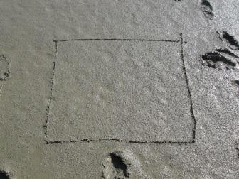
21 Litora - IJzermonding In-situ campaign: YELLOW RED FINAL TRACK IN THE FIELD FLIGHT LINE


22 Litora - IJzermonding In-situ campaign YM31_A YM31_central YM31_B


23 Litora - IJzermonding In-situ campaign


24 Litora - IJzermonding Satellite imagery 1 flight line above IJzermonding: 09:31-09:23 flying height of about 3940m


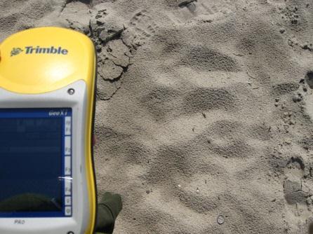
25 Litora - IJzermonding Preliminary results SEDIMENT ANALYSIS GPS measurements STATION Latitude Longitude YM YM YM YM YM YM YM YM YM YM YM YM YM YM YM YM YM YM YM YM YM YM YM12 / / YM34 / / YM35 / / YM YM YM YM YM ASD REFLECTANCE-> REFERENCE TARGETS

26 Litora - IJzermonding Preliminary results ASD REFLECTANCE -> PREPROCESSING All measurements Plots of the 5 measurements taken at each station Quality control: zoom and standard deviation to delete strongly deviating measurements Averaged reflectance per station
27 Litora - IJzermonding FEED BACK: what was good, what could be improved (+) Flight window extended after prolonged period of bad weather conditions -> we still have an image! Possibility to use (calibrated) instruments from the BELAIR pool (-) Difficult to have crew standby beyond the originally agreed flight window. Field sampling did not follow protocol exactly (samples are more than half a meter from center) Insufficient resources to do image analysis -> now taken as master thesis research ( )
28 Litora - Zwin and Lage Moere Background knowledge: several projects on habitat mapping and monitoring with remote sensing since 2003 focus on heathlands, coastal dunes, forests grasslands and tidal areas: knowledge gap Specific aim for BELAIR: to develop practical methodologies for mapping and monitoring biodiversity, in particular habitat types establishing long-term test site is important for ecosystems where longer time-series may provide the key to more successful mapping (grasslands) that are inherently dynamic (tidal areas)


29 Litora - Zwin and Lage Moere Imagery - Airborne hyperspectral campaign Zwin: 8 & 9/07/2013 Lage Moere: 8/07/2013 Processed by VITO

30 Litora - Zwin and Lage Moere Imagery - Satellite Landsat archive data


31 Litora - Zwin and Lage Moere Imagery - UAS Zwin (west): 7 & 10/04/2014 NIR camera Processing ongoing (INBO)

32 Litora - Zwin and Lage Moere In-situ campaign sunphotometer: cf Zeebrugge black/white targets: ASD Zwin: detailed vegetation map summer 2013 Lage Moere: limited set of vegetation relevés (target classes)


33 Litora - Zwin and Lage Moere Outlook & plans Master s thesis KULeuven on grassland monitoring at Zwin Field sampling Zwin grasslands 2014: spectral signature of target classes biomass grasses/forbs ratio species diversity trampling zones Linking ecological indicators with spectral information Spectral Indicators neural networks decision tree classifiers spectral mixture analysis radiative transfer models vegetation indices Band selection Spectral transformation Spectral Weighing cf. Somers et al., RSE, 2011
34 Litora - Zwin and Lage Moere FEEDBACK: what was good, what could be improved (+) data acquisition and processing as requested (-) call for study sites came very late only data budget; analysis depends on additional funding

35 Thank you!
Inland and coastal water quality retrieval Some challenges and new opportunities
 Inland and coastal water quality retrieval Some challenges and new opportunities Els Knaeps, Dries Raymaekers, Sindy Sterckx (VITO, Belgium) Kevin Ruddick, Bouchra Nechad (MUMM, Belgium) Ana Dogliotti
Mapping water constituents concentrations in estuaries using MERIS full resolution satellite data
 Mapping water constituents concentrations in estuaries using MERIS full resolution satellite data David Doxaran, Marcel Babin Laboratoire d Océanographie de Villefranche UMR 7093 CNRS - FRANCE In collaboration
Future remote sensors for chlorophyll a. Dimitry Van der Zande, Quinten Vanhellemont & Kevin Ruddick
 Future remote sensors for chlorophyll a Dimitry Van der Zande, Quinten Vanhellemont & Kevin Ruddick Workshop Scheldt Commission: eutrophication 20 th October 2016 Ocean colour from space ESA MERIS 7 May
Monitoring water quality of the Southeastern Mediterranean sea using remote sensing
 Monitoring water quality of the Southeastern Mediterranean sea using remote sensing Tamir Caras The Remote Sensing Laboratory Jacob Blaustein Institutes for Desert Research Ben-Gurion University of the
Hyperspectral information for vegetation monitoring
 Hyperspectral information for vegetation monitoring Gaia Vaglio Laurin DIBAF Università della Tuscia, CMCC Activities supported by the EU H2020 BACI grant #640176 Italian Space Agency, Rome, 1-3 March
Study of Water Quality using Satellite data
 2nd Workshop on Parameterization of Lakes in Numerical Weather Prediction and Climate Modelling Study of Water Quality using Satellite data M. Potes, M. J. Costa (Évora Geophysics Centre, PORTUGAL) This
USING MERIS DATA FOR THE RETRIEVAL OF CHL A, CDOM AND TSS VALUES IN THE GULF OF FINLAND AND LAKE LOHJANJÄRVI
 USING MERIS DATA FOR THE RETRIEVA OF CH A, CDOM AND TSS VAUES IN THE GUF OF FINAND AND AKE OHJANJÄRVI Sampsa Koponen 1, Jenni Vepsäläinen 2, Jouni Pulliainen 1, Kari Kallio 2, Timo Pyhälahti 2, Antti indfors
EU FP7-SPACE project INFORM
 Improvedmonitoring andforecastingof ecologicalstatus of European INland waters by combining Future earth ObseRvation data and Models Miguel Dionisio Pires Deltares miguel.dionisio@deltares.nl EU FP7-SPACE
EVALUATION OF TWO SITES FOR OCEAN COLOR VALIDATION IN THE TURBID WATERS OF THE RÍO DE LA PLATA (ARGENTINA)
") EVALUATION OF TWO SITES FOR OCEAN COLOR VALIDATION IN THE TURBID WATERS OF THE RÍO DE LA PLATA (ARGENTINA) Dogliotti, A. I. (1), Gossn, J. I. (1), Vanhellemont, Q. (2), Ruddick, K.G. (2) (1) (2) Instituto
EVALUATION OF TWO SITES FOR OCEAN COLOR VALIDATION IN THE TURBID WATERS OF THE RÍO DE LA PLATA (ARGENTINA) Dogliotti, A. I. (1), Gossn, J. I. (1), Vanhellemont, Q. (2), Ruddick, K.G. (2) (1) (2) Instituto
A Remote Sensing Based System for Monitoring Reclamation in Well and Mine Sites
 A Remote Sensing Based System for Monitoring Reclamation in Well and Mine Sites Nadia Rochdi (1), J. Zhang (1), K. Staenz (1), X. Yang (1), B. James (1), D. Rolfson (1), S. Patterson (2), and B. Purdy
METODOLOGIE E APPROCCI PER OSSERVAZIONI IPERSPETTRALI IN ACQUE COSTIERE E INTERNE
 Data Exploitation della missione PRISMA, precursore delle missioni iperspettrali nazionali Roma, 1-3 marzo 2017 METODOLOGIE E APPROCCI PER OSSERVAZIONI IPERSPETTRALI IN ACQUE COSTIERE E INTERNE Federica
Estimation of chlorophyll-a concentration in estuarine waters:
 Estimation of chlorophyll-a concentration in estuarine waters: case study of the Pearl River estuary Yuanzhi Zhang *, Chuqun Chen #, Hongsheng Zhang *, Xiaofei*, Chen Guiying Chen# *Institute of Space
Appendix A. Proposal Format. HICO Data User s Proposal
 Appendix A. Proposal Format HICO Data User s Proposal Title of Proposal: A hyperspectral atmospheric correction algorithm to retrieve water-leaving radiance signal from HICO data Principal Investigator
Note that approval of a data user proposal does not imply Navy S&T financial support.
 HICO Data User Agreement Between the Naval Research Laboratory And The HICO Data User Principal Investigator Issued on: HICO-based water transparency Mapping in Pearl River Estuary (PRE) of South China
Simulating UAV sampling using high-density Lidar data to characterize the structure of short canopies
 Simulating UAV sampling using high-density Lidar data to characterize the structure of short canopies IAPP Project nr. 286079 Aircraft for Environmental and Forest Science AIRFORS Loris Vescovo, Chiara
Remote Sensing for Fire Management
 Remote Sensing for Fire Management FOR 435/535: Remote Sensing for Fire Management 5. Severity A Source of Confusion Field Measures Remote Sensing Measures FOR 435: A Source of Confusion The terms fire
A Unified Approach to Remote Estimation of Chlorophyll a Concentration in Complex Inland, Estuarine, and Coastal waters
 A Unified Approach to Remote Estimation of Chlorophyll a Concentration in Complex Inland, Estuarine, and Coastal waters Wesley J. Moses 1, *, Anatoly A. Gitelson 1, Alexander A. Gilerson 2, and Daniela
Use of EO for integrated Coastal Zone Management [ICZM]
![Use of EO for integrated Coastal Zone Management [ICZM]](/thumbs/78/78380350.jpg "Use of EO for integrated Coastal Zone Management [ICZM]") Use of EO for integrated Coastal Zone Management [ICZM] Prof. George Zalidis Aristotle University of Thessaloniki, School of Agriculture Director of the Laboratory of Applied Soil Science Director of the
Use of EO for integrated Coastal Zone Management [ICZM] Prof. George Zalidis Aristotle University of Thessaloniki, School of Agriculture Director of the Laboratory of Applied Soil Science Director of the
Satellite Remote Sensing of Algal Blooms in the southcentral USA:
 Satellite Remote Sensing of Algal Blooms in the southcentral USA: Landsat 8 based algal and turbidity indices in the Grand Lake watershed Abu Mansaray, Doctoral Candidate Environmental Science Graduate
MULTI-SOURCE SPECTRAL APPROACH FOR EARLY WATER-STRESS DETECTION IN ACTUAL FIELD IRRIGATED CROPS
 Department of Geography and Environmental Studies MULTI-SOURCE SPECTRAL APPROACH FOR EARLY WATER-STRESS DETECTION IN ACTUAL FIELD IRRIGATED CROPS Maria Polinova 1, Thomas Jarmer 2, Anna Brook 1 1 Spectroscopy
Zu-Tao Ou-Yang Center for Global Change and Earth Observation Michigan State University
 Zu-Tao Ou-Yang Center for Global Change and Earth Observation Michigan State University Ocean Color: Spectral Visible Radiometry Color of the ocean contains latent information on the water qualitycdom,
DEVELOP National Program
 National Aeronautics and Space Administration NASA Earth Science Division Applied Sciences Program DEVELOP National Program Gulf of Mexico Oil Spill Monitoring Oil Spill and Wetlands Impact Assessment
Hyperspectral Remote Sensing of Forests - (Evaluation and Validation of EO-1 for Sustainable Development (EVEOSD) Project)
 Project)") Hyperspectral Remote Sensing of Forests - (Evaluation and Validation of EO-1 for Sustainable Development (EVEOSD) Project) Presenter: Jay Pearlman (TRW, Co-I) PI: David G. Goodenough ( ) Co-Is: A. Hollinger
Hyperspectral Remote Sensing of Forests - (Evaluation and Validation of EO-1 for Sustainable Development (EVEOSD) Project) Presenter: Jay Pearlman (TRW, Co-I) PI: David G. Goodenough ( ) Co-Is: A. Hollinger
Satellite based inland and coastal water quality monitoring
 Satellite based inland and coastal water quality monitoring Harmonized transnational, long-term and near-real time space based solutions. Thomas Heege CEO EOMAP Germany Earth Observation & Mapping Inland
for disaster management
 a project using SoA technology for disaster management N. Lewyckyj http://www.osiris-fp6.eu OSIRIS@Globecom December 4 th 2008 OSIRIS is a EC FP6-IST project OSIRIS: Open architecture for Smart and Interoperable
MOVING FROM GLOBAL INFORMATION TO LOCAL DECISION MAKING: AN EXAMPLE FROM WISCONSIN RICK LAWFORD AND STEVE GREB WORLD WATER FORUM IV MARCH 21, 2006
 MOVING FROM GLOBAL INFORMATION TO LOCAL DECISION MAKING: AN EXAMPLE FROM WISCONSIN RICK LAWFORD AND STEVE GREB WORLD WATER FORUM IV MARCH 21, 2006 A VISION THAT MOTIVATES COLLABORATION: IMPLEMENTING A
OCEAN COLOR PRODUCTS RETRIEVAL AND VALIDATION AROUND CHINA COAST WITH MODIS
 OCEAN COLOR PRODUCTS RETRIEVAL AND VALIDATION AROUND CHINA COAST WITH MODIS L. Sun a, M. Guo b, X. Wang b a National Satellite Meteorological Center, China Meteorological Administration, No.46 South Avenue
Trophic state assessment of global large inland waters using the MODIS-derived FUI
 August 2018 Stirling Trophic state assessment of global large inland waters using the MODIS-derived FUI Shenglei Wang Junsheng Li & Bing Zhang Evangelis Spyrakos & Andrew N. Tyler RADI, Chinese Academy
Satellite Monitoring of Water Quality in Lake Manzalah, Egypt. Real-Time Water Quality Monitoring Workshop June St.
 Satellite Monitoring of Water Quality in Lake Manzalah, Egypt Real-Time Water Quality Monitoring Workshop June 16-17 2009 St. John s, Canada Motivation Lakes are vital component of Egypt s water resources
POSSIBILITY OF GCOM-C1 / SGLI FOR CLIMATE CHANGE IMPACTS ANALYZING
 POSSIBILITY OF GCOM-C1 / SGLI FOR CLIMATE CHANGE IMPACTS ANALYZING Y. Honda* a, M. Moriyama b, M. Hori c, M. Murakami c, A. Ono c, K. Kajiwara a a Center for Environmental Remote Sensing (CEReS), Chiba
European Forest Fire Information System (EFFIS) - Rapid Damage Assessment: Appraisal of burnt area maps with MODIS data
 - Rapid Damage Assessment: Appraisal of burnt area maps with MODIS data") European Forest Fire Information System (EFFIS) - Rapid Damage Assessment: Appraisal of burnt area maps with MODIS data Paulo Barbosa European Commission, Joint Research Centre, Institute for Environment
European Forest Fire Information System (EFFIS) - Rapid Damage Assessment: Appraisal of burnt area maps with MODIS data Paulo Barbosa European Commission, Joint Research Centre, Institute for Environment
DUE preparatory activities for Sentinel 2 exploitation: Agriculture, Land Cover Change, Costal Monitoring, Forest Mapping
 DUE preparatory activities for Sentinel 2 exploitation: Agriculture, Land Cover Change, Costal Monitoring, Forest Mapping Fostering the development and validation of EO applications with and for user communities
Mapping Habitat for the Ivory Billed Woodpecker and the California Spotted Owl : A Multisensor Fusion Approach
 Mapping Habitat for the Ivory Billed Woodpecker and the California Spotted Owl : A Multisensor Fusion Approach A. Swatantran 1, R. Dubayah 1, M. Hofton 1, J. B. Blair 2, A. Keister 3 B. Uihlein 3, P. Hyde
Airborne Hyperspectral Potential for Coastal Biogeochemistry of the Scheldt Estuary and Plume
 Airborne Hyperspectral Potential for Coastal Biogeochemistry of the Scheldt Estuary and Plume M. Shimoni & M. Acheroy Signal and Image Centre, Royal Military Academy; D. Sirjacobs & S. Djenidi GeoHydrodynamic
Seagrass Mapping in Lap An lagoon, Viet Nam by Using ALOS AVNIR - 2 Data
 Seagrass Mapping in Lap An lagoon, Viet Nam by Using ALOS AVNIR - 2 Data Supervisor: Prof. K.YOSHINO HA Nam Thang Master course, Graduate school of Environmental and Life Science GDP per capita (2010)
Field Survey and Satellite Validation of Water Quality Parameters of Rivers in the Surroundings of Santo Domingo Metropolitan Area, Dominican Republic
 EMECS 9 (Baltimore, 27 31 August 2011) Field Survey and Satellite Validation of Water Quality Parameters of Rivers in the Surroundings of Santo Domingo Metropolitan Area, Dominican Republic Hiroshima University
Remote Sensing for Monitoring USA Crop Production: What is the State of the Technology
 Remote Sensing for Monitoring USA Crop Production: What is the State of the Technology Monitoring Food Security Threats from Space - A CELC Seminar Centurion, SA 21 April 2016 David M. Johnson Geographer
Invasive Species Mapping in Hawaiian Rainforests Using Multi-Temporal Hyperion Spaceborne Imaging Spectroscopy
 Application Invasive Species Mapping in Hawaiian Rainforests Using Multi-Temporal Hyperion Spaceborne Imaging Spectroscopy Ben Somers Gregory P Asner invasive species threat? invasive species threat? Molnar
Mapping estuarine turbidity using high and medium resolution time series imagery
 Mapping estuarine turbidity using high and medium resolution time series imagery Virginie Lafon Arthur Robinet Tatiana Donnay David Doxaran Bertrand Lubac Eric Maneux Aldo Sottolichio Olivier Hagolle Alexandra
Remote sensing for aquatic habitat quality mapping and EU Water Framework Directive (EU-WFD) reporting
 reporting") Remote sensing for aquatic habitat quality mapping and EU Water Framework Directive (EU-WFD) reporting S. C. J. Palmer 1,2, A. Zlinszky 1, H. Balzter 2, V. R. Tóth 1 1 Balaton Limnological Institute, Hungarian
Remote sensing for aquatic habitat quality mapping and EU Water Framework Directive (EU-WFD) reporting S. C. J. Palmer 1,2, A. Zlinszky 1, H. Balzter 2, V. R. Tóth 1 1 Balaton Limnological Institute, Hungarian
Investigating ecological patterns and processes in tropical forests using GIS and remote sensing
 Investigating ecological patterns and processes in tropical forests using GIS and remote sensing Carlos Portillo-Quintero Center for Earth Observation Sciences (CEOS) Department of Earth & Atmospheric
A Study of Himreen Reservoir Water Quality Using in Situ Measurement and Remote Sensing Techniques
 A Study of Himreen Reservoir Water Quality Using in Situ Measurement and Remote Sensing Techniques Dr. Salah A. H. Saleh College of Science, Nahrain University, Baghdad - IRAQ Abstract The use of remote
Earth Observation & Mapping
 Coastal bathymetry from Wordview-2 satellite data 2012 Thomas Heege EOMAP Germany Magnus Wettle EOMAP Asia Pacific Dave Benson DigitalGlobe London David Chritchley Proteus Abu Dhabi Susanne Lehner German
Operational MODIS Satellite based water turbidity monitoring for dredging operations in Woodside
 DRAFT Operational MODIS Satellite based water turbidity monitoring for dredging operations in Woodside Peter Hausknecht, Woodside - GTO - Geomatics OGP Remote Sensing workshop held at European Space Agency
Forest Changes and Biomass Estimation
 Forest Changes and Biomass Estimation Project Title: Comparative Studies on Carbon Dynamics in Disturbed Forest Ecosystems: Eastern Russia and Northeastern China Supported by NASA Carbon Cycle Science
Developing the next generation of coastal water quality products and services - the FP7/HIGHROC project
 Developing the next generation of coastal water quality products and services - the FP7/HIGHROC project K. Ruddick, C. Brockmann, E. Capuzzo, K. Collingridge, S. Constantin, V. Créach, L. De Keukelaere,
Ocean Diurnal Variations Measured by the Korean Geostationary Ocean Color Imager
 Ocean Diurnal Variations Measured by the Korean Geostationary Ocean Color Imager Menghua Wang 1, Lide Jiang 1,2, Seunghyun Son 1,2, & Wei Shi 1,2 1 NOAA/NESDIS Center for Satellite Applications & Research
NASA Workshop for Remote Sensing of Coastal & Inland Waters
 NASA Workshop for Remote Sensing of Coastal & Inland Waters Madison, Wisconsin June 20-22, 2012 Dr. Robert Shuchman, MTRI George Leshkevich, NOAA GLERL Contributors: Michael Sayers, MTRI Colin Brooks,
User Awareness & Training: LAND. Tallinn, Estonia 9 th / 10 th April 2014 GAF AG
 User Awareness & Training: LAND Tallinn, Estonia 9 th / 10 th April 2014 GAF AG Day 2 - Contents LAND (1) General Introduction to EO and the COPERNICUS Sentinel Programme Overview of COPERNICUS/GMES LAND
Optical classification in contrasted coastal waters for monitoring water masses and improving the assessment of ocean color products
 Optical classification in contrasted coastal waters for monitoring water masses and improving the assessment of ocean color products Vantrepotte V., Loisel H., Mériaux X., and Dessailly D. LOG, CNRS-UMR
FGI meeting May 12, Hyytiälä experiment projects
 FGI meeting May 12, 2009 Hyytiälä experiment 2008 2011 projects Ilkka Korpela Department of Forest Resource Management, University of Helsinki Faculty of Forest Sciences, University of Joensuu Ilkka.korpela@helsinki.fi
Remote Measurements of Active Fire Behavior and Post-Fire Effects
 Remote Measurements of Active Fire Behavior and Post-Fire Effects Alistair Smith (and many many others ) Remote Sensing: A very Brief Overview ~ 5 million years B.C. : Humans Begin to Understand their
The Copernicus Inland Water Service of the European Union. Carsten Brockmann, Kerstin Stelzer, Stefan Simis
 The Copernicus Inland Water Service of the European Union Carsten Brockmann, Kerstin Stelzer, Stefan Simis Copernicus Global Land Service Monitoring the vegetation, the water cycle and the energy budget
K&C Phase 4 Status report. Retrieval of forest biomass and biomass change with spaceborne SAR
 K&C Phase 4 Status report Retrieval of forest biomass and biomass change with spaceborne SAR Johan Fransson 1, Jonas Fridman 1, Ivan Huuva 1 Håkan Olsson 1, Henrik Persson 1, Jörgen Wallerman 1, Maurizio
Using Imagery and LiDAR for cost effective mapping and analysis for timber and biomass inventories
 Using Imagery and LiDAR for cost effective mapping and analysis for timber and biomass inventories Mark Meade: CTO Photo Science Mark Milligan: President LandMark Systems May 2011 Presentation Outline
In-Situ soil moisture and its relation to remotely sensed retrievals
 In-Situ soil moisture and its relation to remotely sensed retrievals Heye Bogena, Carsten Montzka and Harry Vereecken Agrosphere Institute, Forschungszentrum Jülich Soil moisture Soil moisture is: A key
The use of satellite pictures and data provided by drones for the purposes of identification of crops and assessment of plant production
 The use of satellite pictures and data provided by drones for the purposes of identification of crops and assessment of plant production Tomasz Milewski Białobrzeska 11/64, 02-379 Warsaw Central Statistical
Current use and potential of satellite imagery for crop production management
 Current use and potential of satellite imagery for crop production management B. de Solan, A.D. Lesergent, D. Gouache, F. Baret June 4th, 2012 Increasing needs in observation data to optimize crop production
CONAE: Missions, Projects and Initiatives for coasts and oceans. Sandra Torrusio
 CONAE: Missions, Projects and Initiatives for coasts and oceans Sandra Torrusio From de Past to the Future... SAC-C SAOCOM SAC-D AQUARIUS SABIAMar SAC-C 2000-2013 80 Km SSS Rain Wind Water Vapor Sea Ice
Water Quality in Landsat OLI Images
 N. 1, M. H. Islam 2, R. Khanam 3 and M. Iqbal 4 1 MS Researcher, Geography and Environment, Jahangirnagar University, Savar, Dhaka-1342. 2 MS Researcher, Geography and Environment, Jahangirnagar University,
Application of OCEANSAT-2 2 data to study the CASE- 2 waters in the North-Eastern Mediterranean sea (NEMO-C2W)
") Application of OCEANSAT-2 2 data to study the CASE- 2 waters in the North-Eastern Mediterranean sea (NEMO-C2W) IIA PI: Stefano Pignatti Italian National Research Council Atmospheric Pollution E-mail: rosa.cavalli@lara.rm.cnr.it
Application of OCEANSAT-2 2 data to study the CASE- 2 waters in the North-Eastern Mediterranean sea (NEMO-C2W) IIA PI: Stefano Pignatti Italian National Research Council Atmospheric Pollution E-mail: rosa.cavalli@lara.rm.cnr.it
Automatic retrieval of biophysical and biochemical canopy variables: an example based on AHS data from AGRISAR campaign
 Automatic retrieval of biophysical and biochemical canopy variables: an example based on AHS data from AGRISAR campaign Wouter Dorigo, Heike Gerighausen & Erik Borg German Remote Sensing Data Centre, German
Airship-based LiDAR and multi-sensor forest monitoring
 Airship-based LiDAR and multi-sensor forest monitoring S. Esposito, P. Fallavollita, M. Balsi, R. Tognetti, M. Marchetti COST WORKSHOP Green Engineering Camp ( GEC) Plitvice Lakes National Park, Croatia
A Remote Sensing Based Urban Tree Inventory for the Mississippi State University Campus
 A Remote Sensing Based Urban Tree Inventory for the Mississippi State University Campus W. H. Cooke III a and S.G. Lambert b a Geosciences Department, GeoResources Institute, Mississippi State University,
The NISAR Mission. Paul Siqueira Emerging Technologies and Methods in Earth Observation for Agriculture Monitoring College Park, 2018
 The NISAR Mission Paul Siqueira Emerging Technologies and Methods in Earth Observation for Agriculture Monitoring College Park, 2018 Flyer A one-page paper-flyer is available with more information NISAR
Diurnal variability of turbidity and light attenuation in the southern North Sea from the geostationary SEVIRI sensor
 Publication in review in Remote Sensing of the Environment Diurnal variability of turbidity and light attenuation in the southern North Sea from the geostationary SEVIRI sensor Griet Neukermans 1,2 Kevin
Multi temporal remote sensing for yield prediction in sugarcane crops
 Multi temporal remote sensing for yield prediction in sugarcane crops Dr Moshiur Rahman and A/P Andrew Robson (Principal Researcher) Precision Agriculture Research Group, University of New England, NSW,
MAPPING OF PHOTOSYNTHETIC PIGMENTS IN SPANISH RESERVOIRS
 MAPPING OF PHOTOSYNTHETIC PIGMENTS IN SPANISH RESERVOIRS Ramón Peña-Martínez, José Antonio Domínguez-Gómez, Caridad de Hoyos, Antonio Ruiz-Verdú Centro de Estudios Hidrográficos del CEDEX, Pº Bajo de la
Drones: A New Tool for Water Monitoring
 Drones: A New Tool for Water Monitoring Donglai Gong Carl Friedrichs, Ryan Carnegie Outline What are the goals of water monitoring (from marine scientist s perspective)? Healthy ecosystem? Fisheries /
REMOTE SENSING BASED FOREST MAP OF AUSTRIA AND DERIVED ENVIRONMENTAL INDICATORS
 REMOTE SENSING BASED FOREST MAP OF AUSTRIA AND DERIVED ENVIRONMENTAL INDICATORS Heinz GALLAUN a, Mathias SCHARDT a, Stefanie LINSER b a Joanneum Research, Wastiangasse 6, 8010 Graz, Austria, email: heinz.gallaun@joanneum.at
VISualize2012: Climate Change and Environmental Monitoring
 VISualize2012: Climate Change and Environmental Monitoring ESTIMATION OF ABOVE GROUND BIOMASS IN RESTORED JUVENILE MANGROVE STANDS: EVALUATION OF SPECTRAL AND IMAGE DOMAIN OPERATORS UTILIZING AIRBORNE
ASSESSING THE STRUCTURE OF DEGRADED FOREST USING UAV
 ASSESSING THE STRUCTURE OF DEGRADED FOREST USING UAV STUDY CASE IN YUNGAS CLOUD FOREST, NORTH ARGENTINA Fernando Rossi 1, Andreas Fritz 2, Gero Becker 1, Barbara Koch 2 Albert-Ludwigs-Universität Freiburg
Integration of forest inventories with remotely sensed data for biomass mapping: First results for tropical Africa
 Integration of forest inventories with remotely sensed data for biomass mapping: First results for tropical Africa Alessandro Baccini Nadine Laporte Scott J. Goetz Mindy Sun Wayne Walker Jared Stabach
Quality Indicators for Societal Benefit QI4SB Irwin Alber (IEEE/ICEO)
") Quality Indicators for Societal Benefit QI4SB Irwin Alber (IEEE/ICEO) Workshop on Facilitating Implementation of QA4EO CEOS/WGCV 01 October, 2009 Antalya, Turkey 1 Outline QA of GEOSS data products for
Quality Indicators for Societal Benefit QI4SB Irwin Alber (IEEE/ICEO) Workshop on Facilitating Implementation of QA4EO CEOS/WGCV 01 October, 2009 Antalya, Turkey 1 Outline QA of GEOSS data products for
Mangrove deforestation analysis in Northwestern Madagascar Stage 1 - Analysis of historical deforestation
 Mangrove deforestation analysis in Northwestern Madagascar Stage 1 - Analysis of historical deforestation Frédérique Montfort, Clovis Grinand, Marie Nourtier March 2018 1. Context and study area : The
Remote sensing of total suspended sediment within lakes Onoke and Wairarapa
 Remote sensing of total suspended sediment within lakes Onoke and Wairarapa Introduction Remote sensing can provide synoptic monitoring of water quality and temperature (e.g., Kloiber et al. 2002, Dekker
ESA UNCLASSIFIED - For Official Use
 ESA UNCLASSIFIED - For Official Use OPPORTUNITIES OF UAV BASED SENSING FOR VEGETATION LAND PRODUCT VALIDATION Benjamin Brede 1, Juha Suomalainen 2, Peter Roosjen 1, Helge Aasen 3, Lammert Kooistra 1, Harm
Water use and production in the Central Highlands, Aguascalientes and the Lerma-Chapala watershed
 Water use and production in the Central Highlands, Aguascalientes and the Lerma-Chapala watershed 1. Introduction...1 2. Area description... 1 3. Materials and methods... 2 4. Results and Discussion...
Image Classification I
 Image Classification I Classification is the process of labeling image pixels using predetermined categorical classes. Components: Image features Classification scheme Signatures Training Classifiers Classification
Assessment and Monitoring of Marine Environment using Airborne Remote Sensing Technique: Experience of the Institute for Environmental Solutions
 Assessment and Monitoring of Marine Environment using Airborne Remote Sensing Technique: Experience of the Institute for Environmental Solutions Dainis Jakovels Institute for Environmental Solutions, Latvia
County- Scale Carbon Estimation in NASA s Carbon Monitoring System
 County- Scale Carbon Estimation in NASA s Carbon Monitoring System Ralph Dubayah, University of Maryland 1. Motivation There is an urgent need to develop carbon monitoring capabilities at fine scales and
Workshop on 3D Remote Sensing in Forestry - Programme
 Workshop on 3D Remote Sensing in Forestry - Programme 18:00 -. Get-together meeting (Restaurant Esterhazy Keller, Haarhof 1, 1010 Vienna) Monday, 13 th February 2006 08:00-09:00 Registration 09:00-09:30
Synergy between polar-orbiting and geostationary sensors:
 Synergy between polar-orbiting and geostationary sensors: Remote sensing of the ocean at high spatial and high temporal resolution. Quinten Vanhellemont, Griet Neukermans, Kevin Ruddick Management Unit
USE OF THE NEW OLCI AND SLSTR BANDS FOR ATMOSPHERIC CORRECTION OVER TURBID COASTAL AND INLAND WATERS
 USE OF THE NEW AND SLSTR BANDS FOR ATMOSPHERIC CORRECTION OVER TURBID COASTAL AND INLAND WATERS Kevin Ruddick and Quinten Vanhellemont Royal Belgian Institute for Natural Sciences (RBINS), Operational
Carbon dynamics in inland and coastal ecosystems. Dragon 3 ID 10561
 Carbon dynamics in inland and coastal ecosystems Dragon 3 ID 10561 Project Team Ronghua Ma Hongtao Duan Yuchao Zhang Juhua Luo Lin Chen Steven Loiselle Alessandro Donati Claudio Rossi Project Young Scientists
Application of Gliders for Near-Real Time METOC Data Collection Capability for Battlespace Characterization
 DISTRIBUTION STATEMENT A: Approved for public release; distribution is unlimited. Application of Gliders for Near-Real Time METOC Data Collection Capability for Battlespace Characterization Charles Trees
NASA Satellite Ocean Color Timeseries
 NASA Satellite Ocean Color Timeseries Bryan Franz and the NASA Ocean Biology Processing Group International Ocean Color Science Meeting 6-8 May 2013 Ocean Biology Processing Group Multi-mission Ocean Color
ANALYZING THE SPATIAL AND TEMPORAL VARIABILITY OF WATER TURBIDITY IN THE COASTAL AREAS OF THE UAE USING MODIS SATELLITE DATA
 ANALYZING THE SPATIAL AND TEMPORAL VARIABILITY OF WATER TURBIDITY IN THE COASTAL AREAS OF THE UAE USING MODIS SATELLITE DATA Muna R. Al Kaabi, Jacinto Estima and Hosni Ghedira Ocean Color Group - Earth
Using Open Data and New Technology To Tackle the Greening of the CAP from a broader perspective
 Using Open Data and New Technology To Tackle the Greening of the CAP from a broader perspective Prague, 21 st of October Marcel Meijer & Jeroen van de Voort Outline Setting the scene Open Data related
Unmanned Aerial Vehicle (UAV)-Based Remote Sensing for Crop Phenotyping
-Based Remote Sensing for Crop Phenotyping") Unmanned Aerial Vehicle (UAV)-Based Remote Sensing for Crop Phenotyping Sanaz Shafian 1, Nithya Rajan 1, Yeyin Shi 2, John Valasek 3 & Jeff Olsenholler 4 1 Dept. of Soil and Crop Sciences; 2 Dept. of Biological
Unmanned Aerial Vehicle (UAV)-Based Remote Sensing for Crop Phenotyping Sanaz Shafian 1, Nithya Rajan 1, Yeyin Shi 2, John Valasek 3 & Jeff Olsenholler 4 1 Dept. of Soil and Crop Sciences; 2 Dept. of Biological
Land Surface Monitoring from the Moon
 Land Surface Monitoring from the Moon Jack Mustard, Brown University Workshop on Science Associated with Lunar Exploration Architecture Unique Perspective of Lunar Observation Platform Low Earth Orbit:
Austin Ventura, Corbin Spells, Slade Rodrigues and Andrew Ketsdever Mechanical and Aerospace Engineering University of Colorado, Colorado Springs
 Biomimetics: Exploring Flocks, Schools, and Herds for Robotic Swarms Austin Ventura, Corbin Spells, Slade Rodrigues and Andrew Ketsdever Mechanical and Aerospace Engineering University of Colorado, Colorado
GIS and Remote Sensing Analyses of Forest Plantations in Costa Rica s Atlantic Lowland Area
 GIS and Remote Sensing Analyses of Forest Plantations in Costa Rica s Atlantic Lowland Area Investigator: James Donahey 1 Advisors: Marcia Snyder 2, Ann Russell 1, Lisa Schulte 1 Affiliations: 1 Iowa State
Operational low-cost treewise forest inventory using multispectral cameras mounted on drones
 Operational low-cost treewise forest inventory using multispectral cameras mounted on drones Dr. Eugene Lopatin, Natural Resources Institute Finland, eugene.lopatin@luke.fi, +358 29 532 3002 1 Key challenges/opportunities
Ukraine. Space Research Institute
 Ukraine Demonstration objectives Space Research Institute Todeliver consistent information at field scalefor Ukraine using Sen2Agri system: Crop mask; Crop type; Crop status; Early crop area indicators,
Habitat Quality: Model Overview
 Habitat Quality: Model Overview Biodiversity is not treated as an ecosystem service Instead, it s used to assess overlaps and tradeoffs InVEST models habitat quality and rarity as indicators of the status
DEMOCRATIC SOCIALIST REPUBLIC OF SRI LANKA
 SRI LANKA 1 DEMOCRATIC SOCIALIST REPUBLIC OF SRI LANKA Area 65610km2 Water 4.4% Population 20,277,597 Highest biodiversity density in Asia 2 3 Arthur C Clarke Institute for Modern Technologies (ACCIMT)
Great Lakes Remote Sensing Algorithms
 Great Lakes Remote Sensing Algorithms Status, Comparisons, and Future Directions Robert Shuchman MTRI Mike Sayers MTRI George Leshkevich NOAA/GLERL Barry Lesht JGLR/Assoc. Editor Caren Binding Environment
REMOTE SENSING OF EBVS TO MONITOR BIODIVERSITY. Andrew Skidmore, ITC, University Twente
 REMOTE SENSING OF EBVS TO MONITOR BIODIVERSITY Andrew Skidmore, ITC, University Twente INTRODUCTION BIODIVERSITY: THE VARIETY OF LIFE INTRODUCTION WHY BIODIVERSITY MATTERS: THE EXAMPLE OF ECOSYSTEM SERVICES
Carsten Brockmann. Coastal management of estuarine environments: Application of remote sensing. Abstract
 Carsten Brockmann Coastal management of estuarine environments: Application of remote sensing Abstract Proper management of estuarine environments requires appropriate management plans as well as tools