Annual Report of Reservoir Regulation Activities
|
|
|
- Shanna Byrd
- 6 years ago
- Views:
Transcription
1 US Army Corps of Engineers Kansas City District Engineering Division Hydrologic Engineering Branch Water Management Section Annual Report of Reservoir Regulation Activities Summary for Calendar Year 2013 March 2014
2 NORTHWESTERN DIVISION, KANSAS CITY DISTRICT SUMMARY OF LAKE REGULATION ACTIVITIES JANUARY 1, 2013 TO DECEMBER 31, 2013 PURPOSE AND SCOPE....1 LAKES IN THE KANSAS CITY DISTRICT...1 PROJECT FUNCTIONS AND GENERAL PLAN....1 CLIMATOLOGIC AND HYDROLOGIC CONDITIONS...2 PROJECT ACCOMPLISHMENTS....6 PROJECT OPERATIONS MAJOR REGULATION PROBLEMS AND PROPOSED SOLUTIONS WATER CONTROL MANUALS HYDROLOGIC DATA COLLECTION RESEARCH AND STUDIES.22 TRAINING AND METHODS PERSONNEL AND FUNDING List of Tables Table 1: Flood Reduction Benefits...7 Table 2: Visitation Hours...11 Table 3: Project Manual Status and Revision Schedule...16 Table 4: Staff Training...23 Table 5: Water Management Section Personnel...23 Table 6: Data Collection Expenditures...24 Plate 1: Plate 2A: Plate 2B: Plate 2C: Plate 2D: Plate 2E: Appendix A: Appendix B: List of Plates Kansas City District Map Engineering Data, Osage River Basin Projects Engineering Data, Lower Missouri River Basin Projects Engineering Data, Lower Kansas River Basin Projects Engineering Data, Republican River Basin Projects Engineering Data, Smoky Hill River Basin Projects Appendices Summary Plots of Corps of Engineers Projects Summary Plots of Bureau of Reclamation Projects
3 PURPOSE AND SCOPE. This report summarizes the past year's regulation activities at storage projects within the boundaries of the Kansas City District (District) that are operated for flood control by the Water Management Section staff. It also summarizes major work items affecting the projects, and it outlines briefly the programs ongoing or proposed for the year ahead. Topics discussed in the report include recent weather patterns, project accomplishments, current project operations; major regulation problems and proposed solutions; lake regulation manuals; data collection programs and procedures; ongoing studies, and personnel of the Water Management Section. The reporting period for Water Management Section activities covers the operating year from January 1, 2013, through December 31, 2013, with additional discussion on proposed operations and studies programmed through calendar year Preparation of this report is in conformance with paragraph 13b of ER , dated October 8, LAKES IN THE KANSAS CITY DISTRICT. The Kansas City District includes the watershed of the Missouri River from Rulo, Nebraska, (river mile above the mouth) to the junction of the Missouri and Mississippi Rivers near St. Louis, Missouri. During the period covered by this report, 29 storage projects, at which the Corps of Engineers (Corps) has either complete or partial water control responsibilities, were in operation within the District. There are 18 Corps of Engineers lakes and 11 Bureau of Reclamation lakes. The location of each lake and reservoir in the District is shown on Plate 1, and a summary of engineering data outlining the physical characteristics of each project is included as Plates 2A through 2E. PROJECT FUNCTIONS AND GENERAL PLAN. Functions served by storage facilities in the Kansas City District include: flood control, irrigation, water supply, low flow and navigation supplementation, water quality, hydropower, recreation, and fish and wildlife. Most functions except flood control are normally provided through the regulation of storage contained in the multipurpose pool. Releases from multipurpose storage are controlled by the manipulation of gates or other means in accordance with plans, schedules, and ratings prepared in advance to meet various conditions of inflow and demand. The general plan for regulation of flood control storage is to evacuate all accumulations in the flood control space as rapidly as downstream channel capacities and flow conditions permit. Should the top of the flood pool be exceeded, criteria have been developed for each project that schedule releases with an aim toward safeguarding the structure. Downstream interests are warned of the possibility of flooding should a surcharge operation appear likely. Although the storage space in the flood control pool is normally evacuated as quickly as downstream conditions allow, release schedules may be modified at times to serve beneficial purposes such as fish and wildlife enhancement. 1

4 CLIMATOLOGIC AND HYDROLOGIC CONDITIONS. January through March shows above average precipitation across Missouri and east central Kansas with near-normal to below-normal along the Missouri river through western Iowa and eastern Nebraska into the South Dakota. 2
5 Above-normal to much-above-normal precipitation occurred across all of Missouri and Iowa with eastern Kansas slipping into near-normal and western Kansas and southwest Nebraska below-normal. 3

6 Much-below-normal precipitation occurred over the entire state of Iowa, Northern Missouri and eastern Nebraska with near-normal to above-normal across southern Missouri and Kansas. 4
7 A near-normal end to the year in Iowa, Missouri and most of Kansas with above-normal precipitation across the Dakotas, eastern Nebraska and Kansas. 5

8 PROJECT ACCOMPLISHMENTS. Operating purposes at storage projects in the Kansas City District include flood control, irrigation, water supply, low flow and navigation supplementation, water quality, hydropower, recreation, and fish and wildlife. Project accomplishments in each of these functional areas, for the period covered by this report, are described briefly in the following subparagraphs. 6
9 Flood Control. Table 1: Flood Reduction Benefits (Thousand Dollars) Stream flow regulation by storage projects in the Kansas City District began Project Clinton Lake, KS Fiscal Year 2013 $158.8 Cumulative $1,209,701.3 Harlan County Lake, NE $23.2 $228,609.3 with the closure of Kanopolis Harry S Truman Resv., MO $2,965.7 $1,874,112.0 Lake in February By Hillsdale Lake, KS $13.6 $33,552.3 Kanopolis Lake, KS $27,102.2 $1,674,125.8 July of that year, Kanopolis Little Blue River Lakes, MO $0.0 $50,813.0 also provided the first flood Long Branch Lake, MO $0.6 $50,229.5 control storage, benefiting Melvern Lake, KS $36.1 $220,673.5 Milford Lake, KS $103.1 $1,316,953.1 downstream damage centers. Perry Lake, KS $328.5 $5,439,160.8 Since then, stream flow Pomme De Terre Lake, MO $398.1 $69,639.6 Pomona Lake, KS $3.9 $210,136.6 regulation by District projects Rathbun Lake, IA $76.0 $159,064.6 has produced flood reduction Smithville Lake, MO $303.5 $970,550.6 Stockton Lake, MO $702.6 $207,639.6 benefits estimated in the Tuttle Creek Lake, KS $2,832.1 $6,556,494.4 millions of dollars annually. In Wilson Lake, KS $94.6 $1,573,335.0 addition to the Corps of TOTALS $35,142.5 $21,844,791.2 Engineers lake projects, local protection projects in the form of levees, floodwalls, and channel improvements also have provided flood reduction benefits amounting to millions of dollars. Federal and private agricultural levees along with temporary storage of flood flows in the main stem reservoir system above Sioux City provide additional benefits within the District. During the reporting period, 14 of the District lakes stored water in the flood control pools. Flood reduction benefits during Fiscal Year (FY) 2013 credited to all Corps lake projects in the District were $35,142,500. During the same period, benefits credited to Section 7 Bureau of Reclamation projects within the District totaled $1,084,600. The accumulated total of flood control benefits for Bureau projects within the District totaled $1,838,944,400. The upstream main-stem projects are responsible for additional flood damage reductions along the Missouri River within the Kansas City District reach. A compilation of flood reduction benefits at Corps Lakes in the District is shown in Table 1 above. The majority of the period flood reduction benefits were incurred in the Smoky Hill and Osage River basins during July and August, Irrigation. The 2012 (latest year available) crop yields on lands receiving project water in the Nebraska- Kansas Projects were slightly higher than The average corn yield, the principal crop of all reporting districts, was 174 bushels per acre. The start of irrigation releases from project reservoirs was earlier than normal due to the hot and dry conditions experienced during May. Above normal temperatures and well below normal rainfall was experienced during most of the growing season. Daytime high temperatures exceeded the century mark on numerous occasions. Crop yields were greatly reduced in some of the projects area due to the extremely hot conditions. Crop maturity progressed ahead of normal throughout the season. Most irrigation districts had finished with irrigation releases by the end of August and all irrigation districts had finished delivering water by mid September. Corn harvest generally commenced in late October and concluded in November. Only two canals did not divert water in 2012 as a result of short water supplies. 7
10 Normal reservoir operations for Bonny Reservoir have historically been for recreation and fish and wildlife support, although water has been available for water right administration and irrigation purposes. Bonny Reservoir inflows from the South Fork of the Republican River and Landsman Creek are released into Hale Ditch as requested by the Colorado State Engineer. The state can utilize Bonny Reservoir storage water for Hale Ditch and other natural flow appropriators under short-term water service contracts. Most of the 700 acres served by Hale Ditch are now owned and operated by the Division of Wildlife, Colorado Department of Natural Resources. The historic operation pattern of Bonny Reservoir enhanced the spring fish spawn and provided excellent fishing opportunities during the summer and hunting conditions each fall. In September 2011, the state of Colorado ordered all storage water evacuated from Bonny Reservoir for Republican River Compact compliance. As a result, the reservoir fishery was decimated and future operations are unlikely to provide fishing opportunities. Municipal and Industrial Water Supply and Water Quality Control. Three municipalities and one rural water district have executed water service contracts for full or supplemental water supplies from three Reclamation reservoirs. A contract with the city of Norton, Kansas, provides for a maximum annual usage of 1,600 AF from Keith Sebelius Lake (Norton Dam). A contract with Beloit, Kansas, provides for a maximum annual usage of 2,000 AF from Waconda Lake. Waconda Lake also provides up to 1,009 AF of water for a contract with the Mitchell County Rural Water District No. 2. Based on the current State of Kansas Certificate of Appropriation, water usage is not to exceed 737 AF per calendar year. A contract with the City of Russell, Kansas, provides for a maximum annual usage of 2,000 AF from Cedar Bluff Reservoir. During calendar year 2012, the City of Norton used 405 AF of storage from Keith Sebelius Lake for municipal purposes. Storage releases made from Waconda Lake for the city of Beloit totaled 0 AF, with 0 AF bypassed for downstream water quality control as directed by the State Water Commissioner. Releases of 771 AF were made to the Mitchell County Rural Water District No. 2 from Waconda Lake. No water was released from Cedar Bluff Reservoir during 2009 for the City of Russell. The State of Kansas took 0 AF of water for the fish hatchery downstream of Cedar Bluff Dam. Twenty three water supply contracts exist between the Corps of Engineers and the State Agencies at 14 lakes, for lake storage space, annual withdrawals, or surplus water. Contracts exist with eleven other municipalities and rural water districts within Kansas, Missouri, and Iowa. The State of Kansas in turn contracts with a large number of municipalities and industrial sites to supply water from the State s contracted storage space through the water assurance and water marketing programs. To date, assurance districts have been formed for users along the lower Smoky Hill River, lower Kansas River and the State of Kansas portion of the Marais des Cygnes River. Water is supplied within the limits of each contract through designated lake releases or from intakes located on the lake at the following projects: Kanopolis, Milford, Tuttle Creek, 8
11 Perry, Clinton, Melvern, Pomona, Hillsdale, Smithville, Longview, Rathbun, Long Branch, Stockton, and Harry S Truman. Recommendations for minimum stream flows to benefit stream sanitation and for the maintenance of desirable water quality standards were originally established by the U.S. Public Health Service for many river reaches below proposed dams in the District. These recommendations were then utilized to establish minimum release requirements for many of the District lake projects. The minimum release standards set by the Corps water control plans are usually less than the minimum desirable stream flows set by state water authorities. The latter are intended to satisfy water right holders and fish and wildlife flow standards. In some cases, specific water quality storage allocations were included in the project planning to increase the reliability of the minimum flow releases. Depending on the project, the minimum release quantities may be constant through the year, or they may vary seasonally or vary depending on the amount of current lake storage. releases for the purposes of downstream quality control and stream sanitation range from 3 cfs during the winter months at Hillsdale Lake to 100 cfs at Tuttle Creek Lake. Seepage is generally considered sufficient to meet minimum flow requirements downstream of the Reclamation dams. Additional releases are made from Tuttle Creek, Milford, and Perry Lakes for water quality and water supply purposes during periods of low flow on the Kansas River. Releases from any lake may be reduced below minimum requirements for brief periods due to construction, periodic inspections, or emergencies. Navigation. Releases from the Missouri River main stem reservoir system are designed to provide equitable service to navigation and other project purposes, while at the same time recognizing the important flood control functions of the system. Navigation on the Missouri is limited to the ice-free season, with a full season normally extending from April 1 to December 1 at the mouth. Operating experience plus numerous studies have indicated that flows of 35,000 cfs at Kansas City are the minimum that will permit navigation. Groundings can occur with flows of that magnitude, and dredging may be needed to alleviate local problems. Therefore, an additional flow of 6,000 cfs above the minimum service target has been set as the "full service" level for the navigation function. Thus, a full-service target flow of 41,000 cfs at Kansas City is considered adequate to maintain the designed 9-foot by 300-foot channel with little or no dredging. Milford, Tuttle Creek and Perry lakes are at times called upon to supplement Missouri River flows below Kansas City in order to meet the navigation requirement and to conserve water in the main stem lakes. On July 22, 2013 the Reservoir Control Center requested supplemental releases for navigation support. Supplemental navigation releases ended on August 21, A total of 130,878 ac-ft of water was released for supplemental navigation support. The navigation season ended at the Kansas City reach on November 27,
12 Hydropower. Hydropower is generated at two Kansas City District projects. Stockton Dam has one unit with a nameplate rated capacity of 45 megawatts (MW), and an overload generation rate of 52 MW. Harry S Truman Dam has six units with a total nameplate rated capacity of 160 MW, and an overload generation rate of 180 MW. The Southwestern Power Administration markets power from Stockton and Harry S Truman projects. Under a contract funded by ARRA, the Stockton power plant is currently receiving a total rehabilitation. Stockton s power operation continues to be restricted by downstream channel capacities that limit tailwater elevations to feet above mean sea level (msl) and Highway J stages to a maximum reading of 17.5 feet. Generation by the Stockton plant during this report period totaled zero megawatt hours (MWH). Generation by the Harry S Truman plant totaled 314,737 MWH during the period of this report. Power generation releases at Harry S Truman are restricted to four units during the week and three units on weekends between Memorial Day and Labor Day by the Consensus Plan. During the period December 1 to March 1, five units may be operated during the weekdays (total time limited to 600 hours per year) and three units on weekends. The tailwater elevation measured at the Highway 7 Bridge in Warsaw is limited to feet msl, Union Electric datum, during five-unit releases from the power pool. Flood control releases are made through the generation units as much as possible. When Truman pool level is above feet msl, a minimum of one unit is operated continuously. The Consensus Plan for Truman was negotiated and approved between the Corps, the State, and the Southwestern Power Administration, and became effective March Fish and Wildlife. Water level management plans, which include the fluctuation of pool levels at various times of the year for the enhancement of fish and migrating waterfowl, were in effect during the report period at the following Kansas City District lakes: Smithville, Clinton, Hillsdale, Kanopolis, Melvern, Wilson, Pomme de Terre, Perry, Pomona, Milford, Tuttle Creek, Rathbun, Stockton, and Long Branch. Truman Lake makes releases for the downstream spring fish spawn when water is available, in accordance with an agreement with Southwest Power Administration and the State of Missouri. 10
13 Recreation. Recreational use of the Corps lakes is a highly visible and important function. Visitation Recreational use is enhanced when the lakes are Project (Visitor Hours) Clinton Lake, KS 8,915,999 operated close to their normal or multipurpose Harlan County Lake, NE 9,013,566 pool levels. During flood years when large Harry S Truman Resv., MO 17,929,565 Hillsdale Lake, KS 1,073,052 quantities of water are stored in the flood pools Kanopolis Lake, KS 1,614,039 and during drought years when the lake levels Long Branch Lake, MO 2,015,229 Longview/Blue Springs MO 2,687,091 drop, then access to the lakes and the shoreline Melvern Lake, KS 7,507,345 facilities, as well as the quality of the experience, Milford Lake, KS 8,371,766 Perry Lake, KS 6,083,578 is reduced. Park managers at the projects are Pomme de Terre Lake, MO 14,082,974 also concerned about related factors such as Pomona Lake, KS 3,371,446 Rathbun Lake, IA 7,049,884 facility maintenance and water quality. The fish Smithville Lake, MO 8,580,552 and wildlife function is closely related to the Stockton Lake, MO 8,562,376 Tuttle Creek Lake, KS 1,990,305 recreation experience, and coordination with Wilson Lake, KS 2,144,615 state and county park officials for park TOTALS 110,993,382 management is important. A list by projects of the visitation totals at Corps lakes is shown in Table 2. The latest park visitation numbers available are for Project park facilities at Blue Springs, Hillsdale, Long Branch, Longview, and Smithville are leased to county or state agencies. PROJECT OPERATIONS. Table 2: Visitation Hours For Latest Reporting Corps of Engineer Lakes - January1, 2013 through December 31, Flood Pool Storage. During the reporting period there were no prolonged flood-fighting activities at any District lake. 14 of the District s 18 lakes stored at least a little water in their flood control pools. The maximum encroachment into exclusive flood control space was 8.29 feet above multipurpose level (78.5% of FCP) at Long Branch on 19 April All Corps lakes within the Kansas City District were regulated in accordance with normal procedures during the period covered by this report. New record low pool elevations were recorded at Longview and Clinton reservoirs. Details regarding the regulation of all projects are included, along with pool elevation hydrographs, in Appendix A of this report. Deviations. Three deviations from the water control manuals were requested and approved during the reporting period. In April 2013 a deviation was requested to release an additional 13,600 acre-feet of water from sediment storage at Harlan County Lake to benefit the Kansas Bostwick Irrigation District. The deviation was not executed. In May 2013 a deviation request was approved to release 3,000 cfs from Rathbun Lake to speed up evacuation of the flood control pool. Inflows were less than expected and actual releases were limited to 2,000 cfs. 11
14 In August 2013 a deviation request was approved for a 2,500 cfs test release from Rathbun Lake. The purpose for the deviation was to check channel capacity downstream of the dam. The 2,500 cfs release was executed on 26 August Kansas Basin Water Quality Releases. Unlike 2012, no special water quality releases were required in the Kansas basin during Blue-green algae was not a significant problem in 2013 and required no special releases. Bureau of Reclamation Projects 2012 Water Year. Reclamation Conservation Operations. The 2012 inflow was below the dry-year forecast for Bonny, Enders, Lovewell, and Cedar Bluff Reservoirs. The remaining reservoirs had inflows between the dry-year and normal-year forecasts. Five of the eleven reservoirs had below average carryover storage from the 2011 water year. Reservoir releases were made from Medicine Creek, Harlan County, Kirwin, and Glen Elder Dams to maintain or reduce reservoir levels prior to the 2012 irrigation season. Before the irrigation season, Enders, Keith Sebelius, Swanson, and Hugh Butler Lakes, did not have sufficient storage to provide water users with a full water supply. A small amount of flood storage was occupied in Harry Strunk and Harlan County Lakes along with Lovewell Reservoir prior to the irrigation season. Irrigation demands greatly reduced the storage in these project reservoirs throughout the summer. Reservoir storage was below normal at most reservoirs at the end of On September 20, 2011, the state of Colorado ordered that Bonny Reservoir be drained for Republican River Compact compliance. All of the water in Bonny Reservoir was evacuated by the end of May 2012 and no storage has been recorded since. The State of Colorado Order remains in effect and inflows continue to be bypassed. Hugh Butler Lake continues to be maintained near the dead pool level due to the embankment cracking discovered in Repairs began at this facility in 2011 and were completed in the summer of By year s end 19% of the conservation pool had refilled.. 2. Reclamation Flood Control Operations. Harry Strunk, and Lovewell Reservoirs utilized flood pool storage in The water year 2013 flood damages prevented by the operation of Reclamation s Nebraska-Kansas Projects facilities was $1,084,600 as determined by the Corps of Engineers. An additional fiscal year 2013 benefit of $23,200 was credited to Harlan County Lake. The accumulative total of flood control benefits for water years 1951 through 2013 by Reclamation facilities in this report total $1,838,944,400. Operations December 31, Corps and Reclamation storage lakes in the District contained a total of 4,860,397 AF of storage on December 31, Of the total volume in storage, 417,417 AF (9 percent) were contained in the Reclamation lakes and 4,442,980 AF (91 percent) were contained in the Corps projects. Six of the eighteen Corps lakes and none of the eleven Reclamation lakes in the District contained storage in their flood control pools on December 31, The occupied flood control storage amounted to 215,587 AF. This volume compares to zero AF of flood control storage space occupied on December 31,
15 MAJOR REGULATION PROBLEMS AND PROPOSED SOLUTIONS. Drought Effects on Inflows Actual Inflow al Average % of Normal Osage Basin 8,984,250 AF 8,278,785 AF 109% Kansas Basin 1,379,290 AF 3,055,228 AF 45% Smoky Hill Basin 90,654 AF 302,215 AF 30% Republican Basin 48,788 AF 291,262 AF 17% Missouri Locals 118,444 AF 160,678 AF 74% Chariton Basin 487,775 AF 344,472 AF 142% Operational Challenges: Osage Basin- In 2013 inflows returned to normal in the Truman, Stockton, and Pomme de Terre basins. The Melvern, Pomona and Hillsdale basins continue to suffer from below-normal inflows. Stockton Lake continues to supply water to the city of Springfield. The Stockton power plant will be unavailable until mid-2014 due to a major rehabilitation project. Kansas Basin- Drought conditions persisted throughout most of 2013 in the Kansas Basin. This necessitated increasing releases from Milford, Tuttle Creek and Perry Lakes to maintain the Water Quality targets at Topeka and Desoto beginning in June. On 22 July, Missouri Basin Water Management Division requested releases for Navigation support for the Missouri River. Perry Lake provided navigation support on July and again on August. Milford Lake provided navigation support on 9-21 August, and Tuttle Creek Lake provided navigation support on August. At the end of 2013 Milford, Tuttle Creek, and Perry Lakes were all near the multi-purpose pool elevations. Clinton Lake was at elevation feet, (4.10 feet below multi-purpose) which was a new record-low pool elevation. Smoky Hill Basin- Severe drought continued to plague the Smoky Hill basin in Inflows improved from 13% of normal in 2012 to 30% of normal in In cooperation with the Kansas Water Office, efforts are being made to trim releases and conserve water at both Kanopolis and Wilson Lakes. Republican Basin- During 2013 the U.S. Bureau of Reclamation (Reclamation) was able to fully supply the need for water from Harlan County Lake to the Kansas Bostwick Irrigation District. The Nebraska Bostwick Irrigation District (NBID) did not receive any Harlan County Lake water for The State of Nebraska prohibited NBID irrigation in an effort to maintain compliance with the Republican River Compact. 13
16 The State of Nebraska has determined that unless additional water is transferred from Nebraska to Kansas during calendar year 2014, Nebraska will be out of compliance with the Republican River Compact. To reduce water usage within the State, and permit more water to flow into Kansas, Nebraska has issued a closing notice on all water storage rights within the Republican River Basin. The order, effective January 1, 2014, closes all State water storage rights within the Republican River Basin. Reclamation holds a 150,000 acre-feet storage right for Harlan County Lake. The closing notice prohibited Reclamation from storing any additional water in Harlan County Lake effective January 1, On December 31, 2013 the pool elevation of Harlan County Lake was ft.,msl. Reclamation negotiated a one year contract with the Kansas Bostwick Irrigation District to store up to 30,000 acre-feet of water in 2014, with the agreement of the States of Kansas and Nebraska. The contract allows Reclamation to temporarily store water in Harlan County Lake until it may be needed for irrigation within the State of Kansas. Accordingly, in 2013 Nebraska issued a revised closing notice for Harlan County Lake to allow temporary storage for the purpose of providing water to Kansas Bostwick Irrigation District during the 2014 irrigation season. Missouri Locals- releases were maintained most of the year. Longview Lake set a new record low pool elevation of on January Chariton Basin- Routine gate changes were performed during the year. There were no significant operational challenges. Water Level Management Plans Paragraph 8-5 of the Osage River Basin Master Manual, Volume 1, December 1968, reads as follows: Fish and Wildlife. Control and manipulation of water levels, both in the multipurpose pool and in the lower 2 or 3 feet of the flood pool, can be very beneficial to fish and wildlife when properly timed and executed. The level of the reservoir, degree of fluctuation, and timing of these conditions will have an extremely important effect on fish spawning. The possibility of achieving some control of production of rough fish species is also a factor favoring close control and manipulation of water levels. In February 2008 this paragraph was reviewed by Kansas City District counsel and the Reservoir Control Center. A consensus was reached with the following conclusions: a. Paragraph 8-5 applies to each Corps of Engineers reservoir in the Osage basin, and b. Paragraph 8-5 gives the Kansas City District Hydraulic Engineering Branch the authority to approve Water Level Management Plans. 14
17 District Council has determined that it is no longer necessary to seek deviations for Water Level Management Plans at Kanopolis, Long Branch, Perry, Pomona, Stockton, Tuttle Creek, Wilson, or Truman reservoirs. The Chief of the Hydraulic Engineering Branch now has the authority to approve Water Level Management Plans at these lakes. Public hearings are now planned to change the language in the Reservoir Regulation Manuals for Clinton, Hillsdale, Melvern, Milford, Pomme de Terre, Rathbun, Smithville, Keith Sebelius, Kirwin, Lovewell, Waconda, and Webster reservoirs. Endangered Species Act. Releases at Milford and Tuttle Creek Lakes are typically affected each summer by special operations required by the Endangered Species Act (ESA). Two listed bird species, the Piping Plover and the Least Tern, were first reported nesting on sandbars in the Kansas River during the mid-1990 s. These birds have also affected operations along the Missouri River upstream of Omaha since they were first listed under ESA in The Terns and Plovers nesting season typically lasts from May through August. During that period, the Corps monitors the bird nests and when possible restricts releases from upstream lakes to protect them to the extent practical from local uncontrolled runoff. The lakes can only control a portion of the basin runoff from spring and summer storms, and many times the runoff from storms closer to the nests are sufficient to destroy them. In previous years, as much as 17 percent of the flood pool at Tuttle Creek Lake has been forced into storage by ESA concerns. In accordance with a U.S. Fish and Wildlife Service Missouri River Biological Opinion, the District has developed a plan of operation to monitor the nesting areas and coordinate lake releases. In 2013 high river levels inundated the least tern and piping plover nesting habitat on the Kansas River for the majority of the nesting season. At the end of June river levels receded enough to expose some sandbar habitat for a brief period of time. On June 26th the US Fish and Wildlife Service conducted a nesting survey on the river from St. George to St. Mary s but no least terns or piping plovers were observed. Shortly thereafter, river levels increased and inundated critical sandbar habitat for the remainder of the nesting season. There was no requirement for deviation from the reservoir regulation manuals to satisfy ESA considerations. WATER CONTROL MANUALS. Manual Status. This section serves to provide the information requested in paragraph 13c of ER , dated October 8, 1982, regarding the status of water control manuals. Water control plans prepared for specific projects and basins within the Kansas City District have been documented in appropriate manuals as directed by paragraph 6c of the above referenced ER. Paragraph 6c also directs that water control plans be revised as necessary to conform with changing requirements resulting from developments in the basin, improvements in technology, new legislation, or other relevant factors, provided such revisions comply with existing Federal regulations and established Corps of Engineers policy. No water control manuals were submitted to Division for approval during the reporting period. The Schedule and Status of manuals for all projects are shown on Table 3. 15
18 Table 3: Project Manual Status and Revision Schedule Reservoir/Lake Stream/River Owner Report Status Submission Schedule Nebraska Master Manual Republican CE Updated final submitted to NWD for review July 28, 1977 Harlan County Republican CE Major Revision approved by NWD May 10, 2001 Harry Strunk Medicine Creek BR Approved by NWD July 12, 1974 Enders Frenchman Creek BR Approved by NWD March 26, 1973 Swanson Republican BR Flood Control Plan approved by HQUSACE October 6, 1969 Hugh Butler Red Willow Creek BR Flood Control Plan approved by HQUSACE November 21,1969 Colorado Bonny S. Fork Republican BR Approved by HQUSACE October 6, 1969 Kansas Lovewell White Rock Creek BR Minor revision approved March 9, 2010 Milford Republican CE Approved December Minor revision approved Jan 1995 Norton Prairie Dog Creek BR Approved August 28, 1974 Master Manual Smoky Hill CE Approved March 28, 1975 Kanopolis Smoky Hill CE Revision submitted to NWD October 30, 1984 Cedar Bluff Smoky Hill BR Approved by NWD September 25, 1975 Kirwin N. Fork Solomon BR Approved by NWD February 6, 1974 Webster S. Fork Solomon BR Approved by NWD July 16, 1975 Wilson Saline CE Approved by NWD June 18, 1984, subject to comments Waconda Solomon River BR Approved by NWD July 12, 1972 Master Manual Kansas CE Approved by HQUSACE March 22, 1967 subject to comments Tuttle Creek Big Blue CE Approved April 16, Minor revision approved January 1995 Perry Delaware CE Approved July Minor revision approved January 1995 Clinton Wakarusa CE Approved February 12, 1980 Master Manual Osage River CE Approved by HQUSACE Sep 21, 1970 subject to comments Pomona 110 Mile Creek CE Approved February 1973 Melvern Marais Des Cygnes CE Approved June 27, 1985 Hillsdale Big Bull Creek CE Approved by NWD June 19, 1985 Missouri Pomme De Terre Pomme De Terre CE Approved by NWD, February 8, Harry S Truman Osage CE Interim manual approved by NWD May 12, Minor revision approved April 1996 CE Stockton Sac CE Approved August 21, 1975 Smithville Little Platte CE Approved August 12, 1979 Long Branch E. Fk Ltl. Chariton CE Interim manual approved November 21, 1978 Longview Little Blue CE Approved February 15, 1994 Blue Springs E. Fork Little Blue CE Approved January 27, 1994, minor revisions submitted Dec 1994 Iowa Rathbun Chariton CE Approved by NWD, October 19,
19 Other Reports Plates 2A-E list project data showing the date impoundment of storage began, the date the multipurpose pool (the active conservation pool in USBR projects) first filled, and the current status of Standing Instructions for Regulation of Storage in Corps of Engineers Lakes. As indicated in Engineering Manual , it is essential that project operators (dam tenders, operations managers, power plant superintendents) at the various flood control and multiple-purpose reservoirs be supplied with regulation schedules to be followed in case of communication failure. These regulation schedules should be followed in case of communication failure with the headquarters from which instructions are normally issued during flood situations. Standing Instructions have not yet been issued for Harry S Truman Reservoir, Clinton, Hillsdale, Long Branch, Smithville, Longview, and Blue Springs Lakes. HYDROLOGIC DATA COLLECTION. The primary objectives of Kansas City District s hydrologic data program is to provide information on precipitation and stream flow characteristics occurring over and within a particular area for a given period of time. These data are used for many purposes, including the design, construction, and maintenance of a wide variety of structures in and along streams; the management of lake releases during floods; the production of hydropower; the design and maintenance of navigation facilities; the control of pollution; the management of flood plains; the development of recreational facilities; the design of highway bridges and culverts; the establishing and administering of water rights and compacts; and the resolving of political, social, and legal water problems. As with any program, however, the restraint on funds and manpower, and the usefulness of the data obtained will determine to what extent the program will, or should, be pursued at any particular point in time. The overall program of observing, monitoring, and collecting hydrologic and meteorological data in the District is quite extensive yet flexible to meet operational and economic needs. Brief descriptions of the various types of data collection now being utilized are presented in the following paragraphs. Collection and Processing of Water Control Data. Hydrologic data such as precipitation, stream flow, and lake information are collected in the Kansas City District by: individual observers, Corps project offices, the National Weather Service, the Geological Survey, the Bureau of Reclamation, and certain state agencies. Several different methods of communication are used in the Kansas City District to receive this data including: electronic transfer, , and telephone. The electronic transfer of data uses SFTP between agency computers and data transmitted through a satellite downlink and a Local Readout Ground Station (LRGS). Data received by the District is entered onto the Water Management Section s Corps Water Management System (CWMS) by both automated and manual methods, depending on the data source. CWMS and Software developed by Water Management Section staff provides a means to view, screen, and process the data for graphical 17
20 and reporting purposes. The data is then uploaded to the MSC CWMS in Omaha. Daily data and project reports are also available to the public at the Section s web site, The Water Management Section is using a Unix system. Hardware is available in Omaha for a backup server if needed. Automatic Remote Sensors. Data Collection Platforms (DCP s) are the primary means by which Kansas City District obtains remote sensing data on stream stages and lake elevations. The DCP is a sophisticated device that collects the information from a stage/elevation sensor and transmits the data to a GOES satellite for subsequent retrieval by the National Environmental Satellite, Data, and Information Service (NESDIS) at Wallops Island, Virginia. NESDIS then rebroadcasts all data over a single high-speed channel on a Domestic Communications Satellite (DOMSAT). The Water Management Section receives DCP data from NESDIS or directly from the DCP s with a DOMSAT receiver station. Maintenance of the DCP s is performed by the USGS under contract with the Corps of Engineers. For Fiscal Year 2014, the District will support 91 permanent DCP s, unchanged from the previous year. A breakdown of the total number of DCP s, by states, shows 41 units in Missouri, 35 in Kansas, 9 in Nebraska, and 6 in Iowa. Cooperative Streamgaging Programs. Constraints on funds and manpower do not allow the Corps to administer an independent data collection program that satisfies all of its needs. Therefore, assistance is sought from other cooperating agencies. A nationwide program of data collection at selected stream gauging stations has been administered for a number of years by the U.S. Geological Survey (USGS). A similar network of reporting stations has been operated by the National Weather Service (NWS) for their river forecasting services. Arrangements have also been made with the USGS through which they supplement their network of reporting stations, or increase the frequency of reports, to better satisfy Corps needs. The program, designated the Cooperative Hydrologic Reporting Network, is administered by the USGS and supported by funds transferred from the Corps and by National Streamflow Information Program (NSIP) funds. Arrangements for the services provided are made with USGS data chiefs in each state and submitted annually to the Chief of Engineers, through the Division Commander and the Hydraulic Engineering Center, for review and approval. A summary of funds expended for data collection purposes during the report period is included in the Personnel and Funding section at the end of this report. Water Quality Investigations and Monitoring Activities. Lake Projects - All 18 District reservoirs were sampled from April through September for nutrients, pesticides, metals, sediment, chlorophyll a, and in-situ water column profiles. Sampling efficiency was not impacted by weather events in Environmental staff Limnologist and Lake Project personnel completed all monthly lake and inflow sampling according to approved work plans. Moderate drought in the Midwest and most of the Missouri 18
21 River watershed caused low inflows, outflows, and decreasing lake levels. Swim beaches and blue green algae blooms are sampled by District staff, state health departments, and/or contract labs for E. coli bacteria, and harmful algae populations/toxins for public safety alerts and beach closures. There were two health advisories issued in Kansas due to algal toxins, but no warnings issued in 2013 indicating that algal toxin levels and cell counts did not exceed the dangerous levels prohibiting whole body contact recreation. A moderate cyanobacteria bloom at Milford Lake caused one to two week public health advisories for parts or all of Milford in June and July Zebra mussel veliger samples were not collected from six District lakes not classified as infested in District lakes with documented populations of zebra mussels include Wilson, Kanopolis, Perry, Milford, Rathbun, Smithville, and Melvern Lakes. Discovery of adult zebra mussels scraped off a large boat ended positively as a collaborative project with Missouri Department of Conservation resulted in a cove treatment of the estimated affected area. Follow up sampling indicates the treatment was successful. The Melvern Lake zebra mussel population will eventually affect the Marais de Cygnes River and downstream Truman Reservoir. The WQ Program continues to participate with watershed groups for Kanopolis (Smoky Hill), Clinton (Upper Wakarusa), Tuttle Creek, Perry (Delaware River), Pomona, Melvern, Milford, Hillsdale, and Rathbun (Chariton). Missouri River - NWK staff sampled seven Missouri River mainstem sites and eleven Missouri River tributary sites in support of the Missouri River Recovery Program (MRRP) in In conjunction with samples collected by NWO staff, this data will be used to facilitate the application of a HEC-RAS hydrodynamic and water quality model on the lower Missouri River. This sampling was completed on a monthly basis. Flows and water levels did not prevent access to sites or hinder sampling in any way this year. In contrast to the extended flooding in 2011, water levels on the lower Missouri River in 2013 averaged at or below the construction reference plane (CRP) for the majority of the sampling season (March through October) in the lower end of the basin. NWK staff provided detailed water quality analysis and response for the Jameson and Benedictine section 401 permit applications. This included meeting with staff from MDNR, Missouri Clean Water Commission, and KDHE. Both permits were either awarded or waived and allow for shallow water habitat construction to resume in Missouri. Information gained from the NAS historical nutrient study, the SWH site characterizations, and the post-construction chute monitoring will ultimately help the Corps to assess potential water quality impacts from SWH creation efforts and to affirm the Corps position that construction of SWH has no negative impacts on Missouri River water quality. Sediment Observations. Revised Area-Capacity tables were implemented on March 1, 2012 as a result of bathymetric surveys conducted from for the following Kansas Lakes: Kanopolis, Wilson, Milford, Tuttle Creek, Perry, Clinton, Hillsdale, Pomona, and Melvern. In bathymetric data was obtained by contract using ARRA funds for the remaining NWK lakes with the exception of Long Branch. However, no LIDAR (Light Detection and Ranging) data was obtained and Area-Capacity tables could not be developed. The Bathymetric surveys were used to monitor sediment accumulation. 19

22 The US Bureau of Reclamation obtained survey data for Bonny Lake in 2010 and developed new Area-Capacity tables, which were implemented on January 1, Three outlet channels were inspected during the report period: Clinton Lake - ic General Inspection # 12 was conducted on 2-4 April The stilling basin was not dewatered for this inspection. The outlet works were inspected for concrete condition, monolith joint separations, and offsets. No significant defects were noted during the inspection. The outlet channel was visually inspected from the outlet works downstream to Station The area between Stations and has experienced significant bank erosion in recent years. Head cutting in the channel was also noted. The channel has an 8-10 foot plunge pool and scour at the left bank. Enlargement and deepening of the outlet channel suggests that the channel is hydraulically adequate and will continue to function as designed. Degradation ranges were surveyed. Range A continues to be stable. Ranges A1, A2, B are becoming deeper and wider. Ranges C through I are relatively stable. The spillway side slopes are stable, but have some woody vegetation. The spillway floor is in good condition with no evidence of erosion or head cuts. Clinton Outlet Channel Plunge Pool 20
23 Longview Lake - ic General Inspection #13 was conducted 9-10 May Both sides of the stilling basin and banks of the outlet channel were inspected. A full visual inspection of the outlet works was completed. In general, the concrete of both intake and outlet works was found to be in good condition. The spillway floor is grass lined and evenly graded with no signs of erosion. Side slopes of the spillway are in good condition with no signs of slides or sloughing. Grass cover on the side slopes is in good condition. Woody vegetation exists between the spillway entrance and the reservoir however it would be inundated by the lake before a spillway flow occurs. Trees and underbrush are present at the exit of the spillway where the cut for the spillway transitions back to natural ground. The spillway exit is the flow control location where critical depth of flow would occur. Brush present at the spillway exit will not impact spillway discharges. Inspection of the outlet channel and Little Blue River channel downstream of the dam was performed for the periodic inspection. Generally, the outlet channel and river channel are in good condition with only small maintenance items that need to be addressed. Five out of the six degradation ranges were surveyed in September 2013 as part of the periodic inspection. The first degradation range downstream of the dam was not surveyed. Neither of the monuments for the first degradation range could be found and are thought to be destroyed. No concerns were noted with respect to degradation of the Little Blue River Channel downstream of Longview Dam. The outlet channel is hydrologically adequate and is operating as designed. Truman Lake - ic General Inspection #13 was conducted on July The floor of the stilling basin has a long history of erosion damage. In 2011, a contract was executed to overlay the stilling basin floor with new concrete. The repair consists of a single lift of unreinforced concrete 4.9 feet thick. Drains were installed after concrete placement was completed. The overlay construction was done under water because the stilling basin cannot be dewatered due to the stability of the training walls. During placement, the concrete did not selflevel as well as was anticipated. Dive inspections were recommended for the first five years after the overlay. Those inspections have not happened because there have been no significant releases to this point. The outlet channel was visually inspected by boat to the Highway 7 Bridge and by walking along selected reaches of the left and right banks. Degradation ranges below Harry S. Truman Reservoir have not been surveyed since approximately
24 Through an interagency cooperative agreement with the USGS, the District collects point, depth integrated, and bed sediment samples at two Missouri River stations. The Missouri River data at St. Joseph, Kansas City, and Boonville include point velocities. Laboratory analyses are performed at the USGS facility at Rolla, Missouri, and the results are stored in their database. RESEARCH AND STUDIES.. HEC-ResSim Modeling- Water Management staff are currently participating in the development of ResSim models covering the Kansas, and Chariton Rivers. The work is being funded through the Missouri River Recovery Program and will be coordinated with HEC-RAS modeling on the Missouri River for future planning purposes. Applications could include evaluation of Recovery Program alternatives and reservoir regulation manual revisions. This is a multi-year effort involving staff in both the Water Management Section and the Hydrology and Hydraulics Section. Similar work is ongoing in the Omaha District covering the upper portion of the Missouri River Basin. In 2013 the ResSim models are being developed and calibrated. Observed flow records at gage points within the models are being extended back to 1898 using Bulletin 17B and Flow Frequency Study methodologies. Rathbun Lake Manual Revision- The Chariton River ResSim model development is partially funded by Operations Division. The model will be used for evaluation of alternative operation scenarios proposed for a Rathbun Lake Regulation Manual revision. Concurrently, staff have identified and initiated discussions with local stakeholders and State interests. In the years since the manual was last updated in 1980, the basin has experienced two major floods resulting in surcharge operations with two additional events approaching the top of the flood pool, the State has invested heavily in lake facilities including the Honey Creek Resort, extensive land use changes have occurred downstream, and the stilling basin has been upgraded to safely pass flows up to 3000 cfs. Bathymetric Surveys- In 2013, no bathymetric surveys were performed at District lakes. 22
25 TRAINING AND METHODS. Training of Water Management Section staff progresses as time and scheduling permit. Technical abilities are enhanced as individuals continue to pursue courses on their own initiative. During the period of this report, Section employees participated in the training courses listed in Table 4. All staff members attended inhouse training of Violence in the Workplace, Operation Security (OPSEC), Employee Engineer 1 Engineer 2 Engineer 3 Engineer 4 Supervisory Engineer Tech 1 Tech 2 Tech 3 Tech 4 Table 4: Staff Training Course or Training Suicide Prevention and Awareness, Sexual Harassment/Assault Response and Prevention (SHARP), Level 1 Anti-Terrorism Awareness, Individual Development Plan Status (IDP), and Threat Awareness Reporting Program (TARP). None None HEC-HMS None None None None None None PERSONNEL AND FUNDING. Personnel. Authorized positions of the Water Management Section at the close of the fiscal year (September 30, 2013) consisted of one Supervisory Hydraulic Engineer, four Hydraulic Engineers, and four Hydrologic Technicians. At the end of this reporting period, the Section had no vacant positions. A listing of personnel in the Section at the end of the report period by name and title is shown in Table 5. Table 5: Water Management Section Personnel Employee (1) (2) Grade GS-13 GS-12 (4) GS-11 (4) GS-9 (4) GS-11 (4) GS-11 (2) GS-12 (2) GS-12 (2) GS-12 Job Title (1) Supervisory Hydraulic Engineer (2) Hydraulic Engineer (3) Hydrologist (4) Hydrologic Technician Funding. Activities of the Water Management Section are funded from the following sources: Planning Part of the funds appropriated for survey reports, flood plain information studies, and project planning studies are assigned to the Water Management Section for special studies if water control is included in connection with the planning and design. 23
26 Operations and Maintenance Operation of the existing lakes and reservoirs in the Kansas City District requires stream flow forecasting, water control planning, stream gauging, and other related activities for each authorized function at Corps of Engineers projects, and for the flood control function at Bureau of Reclamation projects. Operation and maintenance funds are used for these purposes. Technical Services and Flood Emergency Technical services provided to non-federal interests, flood emergency operations, post flood reports, and the annual flood report are tasks assigned to the Water Management Section. These activities vary from year to year. Special accounts are provided for these services. Individuals in the Section may also receive special funding from other sources when they participate as a technical resource on Project Development Teams. Data Collection Programs The Cooperative Stream Gauging Program with the four U.S. Geological Survey districts (Kansas, Nebraska, Iowa, and Missouri) includes 91 stations. Kansas City District funding for this program during FY 2014 is $1,117,060, a 1.9% increase from FY Fiscal year expenses for data collected in FY 2012 and FY 2013, and the programmed expenses for FY 2014 are shown in Table 6 below. Table 6: Data Collection Expenditures Program FY 2012 FY 2013 FY 2014 U.S.G.S $1,096,138 $1,095,775 $1,117,060 Independent Stations $0 $0 $0 TOTAL $1,096,138 $1,095,775 $1,117,060 24

27
28 SUBJECT MELVERN LAKE POMONA LAKE HILLSDALE LAKE STOCKTON LAKE POMME DE TERRE LAKE HARRY S. TRUMAN RESERVOIR GENERAL Location of Dam Near Melvern, KS Near Pomona, KS Near Paola, KS Near Stockton, MO Near Hermitage MO Near Warsaw, MO (1) With pool at multipurpose level. Stream / River Marais des Cygnes River 110 Mile Creek Big Bull Creek Sac River Pomme de Terre River Osage River (2) Damming height is from the original riverbed to Miles above Mouth the top of the flood control pool. Contributing Drainage Area, square miles , ,914 (4) (3) Based on latest available storage data. The revision Approximate Length of Full Reservoir, miles dates of the current area - capacity tables are indicated Shoreline, miles (1) below with the effective dates in parentheses: Discharge of Record nr Dam Site 68,500 cfs (July 11, 1951) 38,600 cfs (July 11, 1951) 45,200 cfs (July 11, 1951) 120,000 cfs (May 19, 1943) 70,000 cfs (Aug 8, 1927) 259,000 cfs (May 17, 1943) Melvern, February 1986 (effective March 1, 1986) Date of Closure October 2, 1970 July 19, 1962 June 15, 1980 September 23, 1968 June 28, 1960 July 21, 1977 Pomona, March 1990 (effective April 1, 1990) Date Storage Began August 1, 1972 October 18, 1963 September 19, 1981 December 12, 1969 October 29, 1961 February 7, 1979 Hillsdale, 1969 (initial) Date Multipurpose Level Reached April 4, 1975 June 5, 1965 February 23, 1985 December 18, 1971 June 15, 1963 November 29, 1979 Stockton, February 1988 (effective May 1, 1988) Operating Agency Corps of Engineers Corps of Engineers Corps of Engineers Corps of Engineers Corps of Engineers Corps of Engineers Pomme de Terre, February 1985 (effective Mar 85) DAM AND EMBANKMENT for concrete section Harry S. Truman, April 1993 (effective Mar 94) Top of Dam Elevation, feet msl 1, , for embankment (4) The total drainage area above Truman Dam is Length of Dam, feet (net) 9,650 7,750 8,700 plus 3,300 dike 5,100 plus 5,600 dike 4,630 plus 2,790 dike 5,000 plus 7,500 dike 11,500 square miles. The indicated total is the local Damming Height, feet (2) drainage area below the upstream dams. Type of Fill Earth Earth Earth Rock Shell Earth Earth (5) In 1994, 1000 AF of flood control storage at Truman Fill Quantity, cubic yards 9,100,000 5,200,000 6,964,000 7,100,000 5,800,000 8,500,000 Reservoir was reallocated to water supply. SPILLWAY The top of the multipurpose pool was adjusted from Location Left Abutment Right Abutment Right Abutment Left Abutment Right Abutment Center of Dam to Crest Elevation, feet msl 1, , Width, Feet Number, Size, and Type of Gates None None None 4-40 x30.5 Tainter None 4-40 x47.3 Tainter Discharge Capacity, Top of Surcharge Pool 36,000 cfs 50,300 cfs 4,750 cfs 182,500 cfs 73,000 cfs 284,000 cfs RESERVOIR (3) TOTALS Surcharge Pool Elevation and Area 1,073.0 ft msl 22,673 ac 1,025.4 ft msl 14,584 ac ft msl 10,983 ac ft msl 48,053 ac ft msl 25,456 ac ft msl 295,870 ac 417,619 ac Flood Control Pool Elevation and Area 1,057.0 ft msl 13,935 ac 1,003.0 ft msl 8,522 ac ft msl 7,413 ac ft msl 38,281 ac ft msl 15,999 ac ft msl 209,048 ac 293,198 ac Multipurpose Pool Elevation and Area 1,036.0 ft msl 6,912 ac ft msl 3,865 ac ft msl 4,575 ac ft msl 24,632 ac ft msl 7,790 ac ft msl (5) 55,406 ac 103,180 ac Surcharge Storage, AF 1, , ,410 1, , , , , , ,910,768 4,755,736 AF Flood Control Storage, AF 1, , ,207 1, , , , , ,005,392 5,656,179 AF Multipurpose Storage, AF 1, , , , , , ,181,640 2,586,412 AF Gross Storage, AF 1, ,258 1, , , ,650, , ,187,032 8,242,591 AF Design Sediment Reserve Storage 26,000 AF for 100 years 28,000 AF for 100 years 11,000 AF for 100 years 25,000 AF for 100 years 13,000 AF for 50 years 244,000 AF for 100 years Measured Sediment Inflow 4,064 AF (1972 to 1985) 7,045 AF (1963 to 1989) 1,928 AF (1981 to 1993) 8,953 AF (1969 to 1987) 4,358 AF (1961 to 1974) 22,321 AF (1979 to 1992) OUTLET WORKS Location Right Abutment Right Abutment Left Abutment Right Abutment ac = acres River Outlet Type Gated Horseshoe Conduit Gated Horseshoe Conduit Gated Oblong Conduit None Gated Tunnel None AF = acre-feet Number and Size of Conduit x ft = feet Length of Conduit, feet msl = elevation above mean sea level Entrance Invert Elevation ft msl ft msl ft msl ft msl cfs = cubic feet per second Discharge Capacity, Top of Surcharge Pool 6,700 cfs 9,200 cfs 8,200 cfs 12,750 cfs kw = kilowatts Discharge Cap, Top of Flood Control Pool 6,235 cfs 8,170 cfs 7,400 cfs 11,500 cfs hp = horsepower Discharge Cap, Top of Multipurpose Pool 5,520 cfs 6,400 cfs 6,150 cfs 9,650 cfs Service Gates, Number and Size 2-6 x x x x14 Emergency Gates, Number and Size 2-6 x x x x14 Low Flow Gates, Number and Size 2-2 x2 2-2 x2 2-2 x dia 1-24 Butterfly Provision for Power None None None 3-20 x x26.5 POWER FACILITIES Generator Turbine Units, Number 1 6 Generator Name Plate Capacity, kw 45, ,000 Turbine Rating, hp 75,600 (56 ft head) 254,400 Turbine Type Kaplan (Vertical Shaft) Kaplan (Inclined Shaft) (Full Pool) Head and Discharge 112 ft (6,300 cfs) 79.2 ft (31,800 cfs) Avg (Power & MP Pool) Head, Discharge 85 ft (7,900 cfs) 42.5 ft (65,000 cfs) Head and Discharge 62 ft (11,000 cfs) 41 ft (68,000 cfs) SUMMARY OF ENGINEERING DATA Reversible Pump Turbines None 6 OSAGE RIVER BASIN PROJECTS Total Dynamic Head, feet 50 Discharge with 5 Units at Max Head, cfs 27,500 U.S. Army Corps of Engineers Power Required, hp 197,000 Kansas City District Drawdown, feet msl December 2004 Plate 2A REMARKS
29 SUBJECT SMITHVILLE LAKE LONGVIEW LAKE BLUE SPRINGS LAKE RATHBUN LAKE LONG BRANCH LAKE GENERAL Location of Dam Near Smithville, MO Kansas City, MO Kansas City, MO Near Rathbun, IA Near Macon, MO (1) With pool at multipurpose level. Stream / River Little Platte River Little Blue River East Fork Little Blue River Chariton River East Fork Little Chariton River (2) Damming height is from original riverbed to top of flood pool. Miles above Mouth (3) Based on latest available storage data. The revision dates of the Contributing Drainage Area, square miles current area capacity tables are indicated below with the effective Approximate Length of Full Reservoir, miles dates in parentheses: Shoreline, miles (1) Smithville Lake, February 1990 (effective March 1, 1990) Discharge of Record near Dam Site 76,600 cfs (July 20, 1965) 18,700 cfs (August 13, 1982) 11,000 cfs (August 13, 1982) 21,800 cfs (March 31, 1960) 30,000 cfs (April 21, 1973) Longview Lake, May 1970 (initial) Date of Closure July 13, 1976 June 16, 1983 August 12, 1986 September 29, 1967 September 3, 1976 Blue Springs Lake, September 1974 (initial) Date Storage Began October 19, 1979 September 16, 1985 September 27, 1988 November 21, 1969 August 2, 1978 Rathbun Lake, January 2000 (effective December 1, 2000) Date Multipurpose Level Reached June 11, 1982 September 23, 1986 March 18, 1990 October 10, 1970 May 19, 1981 Long Branch Lake, January 1989 (effective October 1, 1989) Operating Agency Corps of Engineers Corps of Engineers Corps of Engineers Corps of Engineers Corps of Engineers (4) Spillway flood routing at Long Branch Lake revised for Emergency DAM AND EMBANKMENT Action Plan, dated Top of Dam Elevation, feet msl (5) Flows above 1,800 cfs result in overtopping of the outlet stilling Length of Dam, feet (net) 4,000 1,900 2,500 10,600 3,550 basin walls Damming Height, feet (2) Type of Fill Rolled Earth Earth Earth and Rock Rolled Earth Rolled Earth Fill Quantity, cubic yards 3,200,000 2,500,000 1,200,000 4,700,000 1,855,000 SPILLWAY Location Right Abutment Left Abutment Left Abutment Right Abutment Right Abutment Crest Elevation, feet msl Width, feet Number, Size, and Type of Gates None None None None None Discharge Capacity, Top of Surcharge Pool 4,800 cfs 22,970 cfs 37,800 cfs 45,600 cfs 9,860 cfs (4) RESERVOIR (3) TOTALS Surcharge Pool Elevation and Area ft msl 14,611 ac ft msl 3,207 ac ft msl 1,200 ac ft msl 31,135 ac ft msl 6,608 ac (4) 56,761 ac Flood Control Pool Elevation and Area ft msl 9,990 ac ft msl 1,964 ac ft msl 982 ac ft msl 22,452 ac ft msl 3,663 ac 39,051 ac Multipurpose Pool Elevation and Area ft msl 7,115 ac ft msl 927 ac ft msl 722 ac ft msl 10,329 ac ft msl 2,429 ac 21,522 ac Recreation Pool Elevation and Area ft msl 432 ac 432 ac Surcharge Storage ,198 AF ,370 AF ,039 AF ,859 AF ,880 AF (4) 707,346 AF Flood Control Storage ,777 AF ,810 AF ,715 AF ,173 AF ,327 AF 521,802 AF Multipurpose Storage ,666 AF ,579 AF ,842 AF ,360 AF ,189 AF 421,636 AF Recreation Storage ,555 AF 8,555 AF Gross Storage ,443 AF ,944 AF ,557 AF ,533 AF ,516 AF 951,993 AF Design Sediment Reserve Storage 52,300 AF for 100 years 2,000 AF for 100 years 300 AF for 100 years 24,000 AF for 100 years 4,000 AF for 100 years Measured Sediment Inflow 4,987 AF (1979 to 1993) 20 AF/year (estimated) 3 AF/year (estimated) 240 AF/year (estimated) 483 AF (1978 to 1988) OUTLET WORKS Location Right Abutment Left Abutment Right Abutment Right Abutment Right Abutment River Outlet Type Rectangular Conduit Concrete Arch Arch Conduit Horseshoe Conduit Concrete Arch ac = acres Number and Size of Conduit 1-8 x x x x5.5 AF = acre-feet Length of Conduit, feet ft = feet Entrance Invert Elevation ft msl ft msl ft msl ft msl ft msl msl = elevation above mean sea level Drop Inlet Crest Elevation ft msl cfs = cubic feet per second Low Flow Gate Intake Elevation Discharge Cap, Top Flood Control Pool 3,150 cfs 1,200 cfs 570 cfs 5,160 cfs (5) 910 cfs Discharge Cap, Top of Multipurpose Pool 2,940 cfs 0 (except low flow outlets) 0 (except low flow outlets) 4,220 cfs (5) 495 cfs Service Gates, Number and Size x9.25 Slide 2-6 x12 Slide 2-24 Slide Emergency Gates, Number and Size x9.25 Slide 1-6 x x5 2-6 x12 Slide 1-6 x6 Low Flow Gates, Number, Size, Type 2-24 Knife Valves 1-2 Knife Valve Low Flow Gates, Number and Size 1-2 x Knife Valves 1-2 Knife Valve 2-2 x2 Slide 1-18 Slide Provision for Power None None None None None Provision for Water Supply Pipe None None No pipe outlets, water supply No pipe outlets, water supply A portion of MP storage released to river pumped from pool. pumped from pool SUMMARY OF ENGINEERING DATA LOWER MISSOURI RIVER BASIN PROJECTS REMARKS U.S. Army Corps of Engineers Kansas City Distict December 2004 Plate 2B
30 SUBJECT MILFORD LAKE TUTTLE CREEK LAKE PERRY LAKE GENERAL Location of Dam Near Junction City, KS Near Manhatten, KS Near Perry, KS Near Lawrence, KS (1) With pool at multipurpose level. Stream / River Republican River Big Blue River Delaware River Wakanusa River (2) Damming height is from the original riverbed to the top of the flood control pool. Miles above Mouth (3) Based on latest available storage data. The revision dates of the current Contributing Drainage Area, square miles 17,388 (4) 9,628 1, area - capacity tables are indicated below with the effective dates in parentheses: Approximate Length of Full Reservoir, miles Milford Lake, March 1982 (effective March 10, 1982) Shoreline, miles (1) Tuttle Creek Lake, October 2000 (effective February 1, 2001) Discharge of Record near Dam Site 171,000 cfs (June 3, 1935) 98,000 cfs (June 1951) 94,600 cfs (June 1951) 24,200 cfs (July 1951) Perry Lake, May 1990 (effective June 1, 1990) Date of Closure August 24, 1964 July 20, 1959 August 2, 1966 August 23, 1975 Clinton Lake, December 1991 (effective March 1, 1994) Date Storage Began January 16, 1967 March 7, 1962 January 15, 1969 November 30, 1977 (4) Total drainage area above Milford is 38,621 square miles. The indicated total is Date Multipurpose Level Reached July 14, 1967 April 29, 1963 June 3, 1970 April 3, 1980 the local drainage area below Harlan County Dam. Operating Agency Corps of Engineers Corps of Engineers Corps of Engineers Corps of Engineers DAM AND EMBANKMENT ac = acres Top of Dam Elevation, feet msl 1, , AF = acre-feet Length of Dam, feet (net) 6,300 7,487 7,750 9,250 ft = feet Damming Height, feet (2) msl = elevation above mean sea level Type of Fill Earth Earth, Rock Earth Earth cfs = cubic feet per second Fill Quantity, cubic yards 15,000,000 21,000,000 8,000,000 10,423,000 SPILLWAY Location Right Abutment Left Abutment Left Abutment Left Abutment Crest Elevation, feet msl 1, , Width, feet 1,250 1, Number, Size, and Type of Gates None x20 Tainter None None Discharge Capacity, Top of Surcharge Pool 560,000 cfs 579,000 cfs 65,000 cfs 44,200 cfs RESERVOIR (3) TOTALS Surcharge Pool Elevation and Area 1,208.2 ft msl 59,886 ac 1,151.4 ft msl 70,030 ac ft msl 42,656 ac ft msl 18,336 ac 190,908 ac Flood Control Pool Elevation and Area 1,176.2 ft msl 32,979 ac 1,136.0 ft msl 53,050 ac ft msl 25,363 ac ft msl 12,890 ac 124,282 ac Multipurpose Pool Elevation and Area 1,144.4 ft msl 15,709 ac 1,075.0 ft msl 12,617 ac ft msl 11,146 ac ft msl 7,120 ac 46,592 ac Surcharge Storage 1, , ,442,049 AF 1, , ,272 AF ,375 AF ,809 AF 3,359,505 AF Flood Control Storage 1, , ,669 AF 1, , ,870,735 AF ,795 AF ,783 AF 3,411,982 AF Multipurpose Storage 1, , ,816 AF 1, , ,137 AF ,513 AF ,334 AF 1,003,800 AF Gross Storage 1, , ,145,485 AF 1, , ,150,872 AF ,308 AF ,117 AF 4,415,782 AF Design Sediment Reserve Storage 160,000 AF for 100 years 240,312 AF for 50 years 140,000 AF for 100 years 28,500 AF for 100 years Measured Sediment Inflow 47,935 AF (1967 to 1994) 216,145 AF (1962 to 2000) 49,057 AF (1969 to 1993) 3,421 AF (1977 to 1991) OUTLET WORKS Location Right Abutment Right Abutment Near Center of Dam Left Abutment River Outlet Type Gated Conduit Gated Conduit Gated Conduit Gated Conduit Number and Size of Conduit x13 Arch Length of Conduit, feet Entrance Invert Elevation 1,080.0 ft msl 1,003.0 ft msl ft msl ft msl Gated Sluice, Number and Size None None None None Discharge Cap, Top of Flood Control Pool 23,100 cfs 45,900 cfs 27,500 cfs 7,570 cfs Discharge Cap, Top of Multipurpose Pool 18,600 cfs 31,300 cfs 21,200 cfs 5,900 cfs Service Gates, Number and Size x x x x12.67 Emergency Gates, Number and Size x x x x12.67 Low Flow Gates, Number and Size 2-2 x Butterfly Valve 2-2 x Knife Gate Value Water Supply Gate, Number and Size None None None 1-54 x54 Slide Gate Provision for Irrigation None None None None Provision for Power None None None None Provision for Water Supply No pipe outlets, water supply No pipe outlets, water supply No pipe outlets, water supply 36 Steel Pipe released to river released to river released to river CLINTON LAKE REMARKS SUMMARY OF ENGINEERING DATA LOWER KANSAS RIVER BASIN PROJECTS U.S. Army Corps of Engineers Kansas City District December 2004 Plate 2C
31 SUBJECT BONNY RESERVOIR SWANSON LAKE ENDERS RESERVOIR HUGH BUTLER LAKE HARRY STRUNK LAKE KEITH SEBELIUS LAKE (Norton Dam) HARLAN COUNTY LAKE LOVEWELL RESERVOIR GENERAL (1) With pool at MP level. Location of Dam Near Hale, CO Near Trenten, NE Near Enders, NE Near McCook, NE Near Cambridge, NE Near Norton, KS Nr Republican City, NE Near Lovewell, KS (2) Damming height is Stream / River S. Fk Republican River Republican River Frenchman Creek Red Willow Creek Medicine Creek Prairie Dog Creek Republican River White Rock Creek from original riverbed to Miles above Mouth top of flood control pool. Contributing Drainage Area, sq mi 1,435 2,506 below Bonny ,169 below u/s dams (5) 358 (3) Based on latest storage Approx Length of Full Resv, miles data. Date of current area Shoreline, miles (1) capacity tables given below Max. Disch. of Record nr Dam Site 103,000 (May 31, 1935) 200,000 (May 31, 1935) Insufficient Data 30,000 (June 22, 1947) 120,000 (June 1947) 37,500 (May 28, 1953) 260,000 (June 1, 1935) 23,300 (July 10, 1950) with effective date in ( ). Date of Closure July 6, 1950 May 4, 1953 October 23, 1950 September 5, 1961 August 8, 1949 January 28, 1964 July 22, 1951 May 29, 1957 Bonny, Mar 51 (initial) Date Storage Began July 6, 1950 May 4, 1953 October 23, 1950 September 5, 1961 August 8, 1949 October 5, 1964 November 14, 1952 October 2, 1957 Swanson, Feb 84 (Jan 84) Date Multipurpose Level Reached March 19, 1954 May 15, 1957 January 29, 1952 May 21, 1967 April 2, 1951 June 21, 1967 June 14, 1957 May 20, 1958 Enders, May 97 (Jan 1, 99) Operating Agency Bureau of Reclamation Bureau of Reclamation Bureau of Reclamation Bureau of Reclamation Bureau of Reclamation Bureau of Reclamation Corps of Engineers Bureau of Reclamation Butler, May 97 (Jan 1, 99) DAM AND EMBANKMENT Strunk, Oct 82 (Feb 1, 83) Top of Dam Elevation, feet msl 3, , , , , , , ,616.0 Sebelius, Sep 00 (Jan 02) Length of Dam, feet (Less Spillway) 9, ,600 2,242 3,159 5,665 6,344 11,830 8,392 Harlan, Jan 01 (Jan 1, 01) Damming Height, feet (2) About Lovewell, Jun 95 (Jan 97) Type of Fill Earth Earth Earth Earth Earth Earth Earth Earth (4) Bartley Div Dam, Rep Fill Quantity, cubic yards 8,853,000 8,130,000 1,950,000 3,122,000 2,730,000 3,740,000 13,400,000 3,000,000 R. below Red Willow Ck, SPILLWAY conc ogee weir w/2-10x16 Location Left Abutment Left Abutment Right Abutment Right Abutment Left Abutment Right Abutment Center of Dam Right Abutment gates to rivr, 2-10 x3 gates Crest Elevation, feet msl 3, , , , ,386.2 (see also below) 2, , ,575.3 to canal, max cap 130 cfs. Width, feet (circ morning glory) Franklin pumps on Rep R. Number, Size, and Type of Gates None (see notes below) 3-42 x 30 Radial 6-50 x 30 Radial None None 3-30 x36.35 Radial x30 Radial 2-25 x20 Radial blw Harlan Cty, cap 40 cfs. Disch. Cap. Top of Surcharge Pool 73,300 cfs (with sluice) 126,000 cfs 202,000 cfs (with notch) 4,910 cfs 99,000 cfs (with notch) 96,000 cfs 480,000 cfs 35,000 cfs Courtland Div Dam, Rep R RESERVOIR (3) TOTALS Surcharge Pool Elev (ft msl), Area 3, ,579 ac 2, ,035 ac 3,129.5 ft msl 2,557 ac 2,628.0 ft msl 4,079 ac 2,408.9 ft msl 5,784 ac 2,341.0 ft msl 6,713 ac 1,975.5 ft msl 24,339 ac 1,610.3 ft msl 7,635 ac 69,721 ac Flood Cntrl Pool Elev (ft msl), Area 3, ,036 ac 2, ,940 ac 3,127.0 ft msl 2,405 ac 2,604.9 ft msl 2,681 ac 2,386.2 ft msl 3,483 ac 2,331.4 ft msl 5,316 ac 1,973.5 ft msl 23,431 ac 1,595.3 ft msl 5,024 ac 55,316 ac MP, or Top Cons Pool Elev, Area 3, ,042 ac 2, ,922 ac 3,112.3 ft msl 1,707 ac 2,581.8 ft msl 1,621 ac 2,366.1 ft msl 1,840 ac 2,304.3 ft msl 2,181 ac 1, msl 13,305 ac 1,582.6 ft msl 2,987 ac 30,605 ac Inactive Pool Elev (ft msl), Area 3, ac 2, ,411 ac 3,082.4 ft msl 627 ac 2,558.0 ft msl 715 ac 2,343.0 ft msl 701 ac 2,280.4 ft msl 575 ac 1,932.5 ft msl 9,282 ac 1,571.7 ft msl 1,495 ac 15,137 ac Dead Stor Pool Elev (ft msl), Area 3, ac 2, ac 3,080.0 ft msl 567 ac 2,552.0 ft msl 536 ac 2,335.0 ft msl 481 ac 2,275.0 ft msl 317 ac 1,885.0 ft msl 0 ac 1, ft msl 494 ac 3,125 ac Surcharge Storage, AF 3, , ,230 2,785-2, ,610 3, ,127 6,203 2, , ,829 2, , , , ,287 1, , ,767 1, , , ,731 AF Flood Control Storage, AF 3, , ,820 2,773-2, ,077 3, , ,048 2, , ,846 2, , ,715 2, , ,230 1, ,000 1, , ,465 1,044,201 AF MP, or Active Conserv Storage, AF 3, ,638 39,206 2,752-2,720 99,784 3, , ,962 2, ,558 27,303 2, ,343 26,846 2, , ,517 1, ,000 1, , , ,640 AF Inactive Storage, AF 3, , ,720-2,710 10,312 3, ,080 1,432 2, ,552 3,736 2, ,335 4,699 2, ,275 2,357 1, , ,111 1, , , ,348 AF Dead Storage, AF 3, ,617 1,418 2,710-2,701 2,118 3, ,050 7,516 2, ,527 5,185 2, , ,160 2, ,262 1,636 Sluice crest at 1, , , ,659 23,692 AF Gross Storage, AF 3, , ,160 2,773-2, ,291 3, ,050 72,958 2, ,527 85,070 2, , ,420 2, , ,740 1, , ,111 1, , ,131 1,696,881 AF Design Sediment Reserve Storage 8,000 AF for 50 years 51,000 AF for 50 years 4,000 AF for 100 years 10,000 AF for 50 years 15,000 AF for 50 years 6,000 AF for 50 years 200,000 AF for 100 yrs 8,000 AF for 50 years Measured Sediment Inflow 160 AF/year (estimated) 7,659 AF (1953 to 1982) 1,572 AF (1950 to 1997) 1,616AF (1961 to 1997) 4,397 AF (1949 to 1981) 1,617 AF (1964 to 2000) 38,548 AF ( ) 6,021 AF (1957 to 1995) OUTLET WORKS at Guide Rock, conc ogee Location Left Abutment Left Abutment Right Abutment Right Abutment Right Abutment Left Abutment Center of Dam Right Abutment w/2-20 x12 gates to river River Outlet Type Gated Conduit Gated Conduit Gated Conduit Gated Conduit Gated Conduit Gated Conduit Gated Sluices Spillway gates used for 5-10 x6 gates to Courtland Number and Size of Conduit 1 56 Cond to 26 Pipe 2-6 x Cond to 84 Pipe Cond to 44 Pipe 1 48 Cond to 38 Pipe 9-5 x8 thru Spillway river releases. Gated canal (cap 751 cfs), 1-10x6 Length of Conduit, feet to Gate, 145 to Basin wasteway with 1-10 x9 gate to Superior (cap 139). Entrance Crest Elevation 3,635.5 ft msl 2,710.0 ft msl 3,080.0 ft msl 2,552.0 ft msl 2,335.0 ft msl 2,275.0 ft msl 1,885.0 ft msl radial gate from outlet Other private diversion Disch Cap, Top of Flood Cntrl Pool 140 cfs (approx) 4,300 cfs 1,430 cfs 1,170 cfs 398 cfs (max elev 2,379) 312 cfs 20,700 cfs canal to stilling basin. weirs exist on some creeks Disch Cap, Top of MP (Consv) Pool 103 cfs 3,500 cfs 1,300 cfs 990 cfs 361 cfs 257 cfs 17,370 cfs Wasteway is not used. like Riverside blw Enders Service Gates, Number, Size, Type 1-24 Hollow Jet Valve 2-6 x 7.5 Slide Gates 2-60 Hollow Jet Valves 2-42 Slide Gates 1-39 Slide Gate 1-33 Slide Gate 9-5 x 8 Slide Gates None but div capacity minimal. Provision for Irrigation 1-32 Pipe to 24 Valve 1-56 Pipe to 4 Gate None None None None ; Conduits 1-8 x10 Gated Outlet (5) 13,536 sq mi total Provision for Power None None None None None None 12 x12 Plug for 9 Cond None contributing with u/s dams. Provision for Municipal Supply None None None None None 1-16 Pipe to 16 Gate None None ac = acres ft = feet Other Outlet 1-40 Capped Conduit None None None None None 1-18 outlet for low flow Note: Inflow to lake also AF = acre-feet regulation in mono 20. provided from gated cfs = cubic feet per sec Notes: Spillway also has Notes: Irrigation outlet Notes: Spillway has Note: Concrete ogee weir Notes: Spillway also has Notes: Concrete ogee Franklin Canal conduit to Courtland Canal outlet. msl = elev abv mean sea lvl 16.5 x21.5 sluice, with in right abutment. an uncontrolled notch w/ diversion dam 13 miles an uncontrolled notch w/ weir diversion dam gates, cap 520 cfs x gate, crest elevation at downstream, w/ 1-6 x18 crest elevation at miles downstream, with Naponee Canal conduit SUMMARY OF ENGINEERING DATA crest elev 3, The Concrete ogee weir radial gate to river, and Concrete ogee weir div- 1 6 x18 radial gate to to 1-24 valve, cap 40 REPUBLICAN RIVER BASIN PROJECTS 56 gated outlet conduit diversion dam 52 miles 2-5 x4 regulating gates ersion dam at mile river, 2 6 x5 gates to cfs. See also note (4) feeds all three gated sub d/s, w/ 2-14 x 9.5 gates to canal (max cap 90 cfs) on Rep. R. blw Med Ck. Main Canal (cap 100 cfs) U.S. Army Corps of Engineers outlets. Capacity of irrig plus 30 gated condut to Bartley Diversion Dam 2-10 x14 gates to river and 2 5 x4 gates to Kansas City District pipe outlet limited to river, and 2-10 x6 gates located below Rep. R. and 4-10 x14 gates to South Canal (capacity December cfs by canal cap. to canal (cap 400 cfs). confluence. See note (4) canal (max cap 325 cfs). 36 cfs). Plate 2D REMARKS
32 SUBJECT WACONDA LAKE KIRWIN RESERVOIR WEBSTER RESERVOIR WILSON LAKE KANOPOLIS LAKE CEDAR BLUFF RESERVOIR GENERAL (1) With pool at multipurpose or full conservation level. Location of Dam Near Glen Elder, KS Near Kirwin, KS Near Stockton, KS Near Wilson, KS Near Ellsworth, KS Near Ellis, KS (2) Damming height is height from original river bed to Stream / River Solomon River North Fork Solomon River South Fork Solomon River Saline River Smoky Hill River Smoky Hill River top of flood control pool. Miles above Mouth (3) Based on latest available storage data. The dates of Contributing Drainage Area, sq miles 2,559 below u/s dams (4) 1,367 1,150 1,917 2,330 blw Cedar Bluff (6) 5,365 the current area - capacity tables are indicated below Approx Length of Full Reservoir, miles (1) along with the effective dates in parenthesis: Shoreline, miles (1) Waconda, July 2001 (effective January 1, 2003) Discharge of Record nr Dam Site 125,000 cfs (July 1951) 24,000 cfs (Sep 1919) 55,200 cfs (July 1951) 25,700 cfs (Jul-Aug 1928) 61,000 cfs (June 1938) 98,000 cfs (May 1938) Kirwin, May 1996 (effective January 1, 1998) Date of Closure October 18, 1967 March 7, 1955 May 3, 1956 September 3, 1963 July 26, 1946 November 13, 1950 Webster, May 1996 (effective January 1, 1998) Date Storage Began July 24, 1968 October 5, 1955 May 3, 1956 December 29, 1964 February 17, 1948 November 13, 1950 Wilson, December 1984 (effective January 1, 1985) Date Multipurpose Level Reached May 16, 1973 July 2, 1957 June 18, 1957 March 12, 1973 July 19, 1948 June 21, 1951 Kanopolis, February 1983 (effective March 1, 1983) Operating Agency Bureau of Reclamation Bureau of Reclamation Bureau of Reclamation Corps of Engineers Corps of Engineers Bureau of Reclamation Cedar Bluff, March 2001 (effective January 1, 2002) DAM AND EMBANKMENT (4) Total DA with Kirwin and Webster = 5,076 sq miles Top of Dam Elevation, feet msl 1, , , , , ,198.0 (5) 7 conduit from intake tower to gate chamber. 4 x5 Length of Dam, feet (Less Spillway) 14,631 12,246 10,604 5,600 15,360 12,409.5 emergency gate to 60 pipe. Entrance to stilling well Damming Height, feet (2) controlled by 4 x5 slide gate. From stilling well, 42 Type of Fill Earth Earth Earth Earth Earth Earth river outlet pipe controlled by 36 gate. River outlet Fill Quantity, cubic yards 8,050,000 9,537,000 8,145,000 8,500,000 15,200,000 8,490,000 capacity at top of MP pool and flood control pool about SPILLWAY 220 cfs. Length of combined pipes from intake to Location Right Abutment Right Abutment Left Abutment Right Abutment Right Abutment Right Abutment stilling well about 500. About 200 more to stilling Crest Elevation, feet msl 1, , , , , ,166.0 basin. Canal releases from two openings at top of Width, feet (uncontrolled) (uncontrolled) 500 (uncontrolled) (uncontrolled length) stilling well. Canal capacity is about 175 cfs, but Number, Size, and Type of Gates x21.76 Radial None, but see note below x39.51 Radial None None Gated orifice, see note blw combined capacity with river outlet about 395 cfs. Discharge Capacity at Top of Surcharge Pool 278,000 cfs 96,000 cfs (sluices closed) 138,000 cfs 15,700 cfs 172,000 cfs 84,000 cfs (with orifice) (6) Total contrib. DA with Cedar Bluff = 7,695 sq miles RESERVOIR (3) TOTALS Surcharge Pool Elevation (ft msl), Area 1,492.9 ft msl 38,178 ac 1,773.0 ft msl 14,660 ac 1,938.0 ft msl 11,270 ac 1,587.5 ft msl 33,882 ac 1,531.8 ft msl 23,408 ac 2,192.0 ft msl 16,510 ac 137,908 ac Flood Control Pool Elevation (ft msl), Area 1,488.3 ft msl 33,682 ac 1,757.3 ft msl 10,639 ac 1,923.7 ft msl 8,478 ac 1,554.0 ft msl 20,027 ac 1,508.0 ft msl 13,958 ac 2,166.0 ft msl 10,790 ac 97,574 ac Multipurpose, or Top Cons Pool Elev, Area 1,455.6 ft msl 12,602 ac 1, ft msl 5,071 ac 1, ft msl 3,767 ac 1,516.0 ft msl 9,045 ac 1,463.0 ft msl 3,406 ac 2,144.0 ft msl 6,869 ac 40,760 ac Inactive Pool Elevation (ft msl), Area 1,428.0 ft msl 3,020 ac 1,697.0 ft msl 1,006 ac 1,860.0 ft msl 904 ac 2,107.8 ft msl 1,907 ac Dead Storage Pool Elevation (ft msl), Area 1,407.8 ft msl 248 ac 1,693.0 ft msl 765 ac 1,855.5 ft msl 440 ac 2,090.0 ft msl 755 ac Surcharge Storage, AF 1, , ,798 1, , ,467 1, , ,912 1, , ,263 1, , ,655 2, , ,250 2,229,345 AF Flood Control Storage, AF 1, , ,988 1, , ,136 1, , ,353 1, , ,204 1, , ,278 2, , ,890 2,212,849 AF MP, or Active Conservation Storage, AF 1, , ,183 1, , ,639 1, , ,926 1, , ,528 1, , ,474 2, , , ,628 AF Inactive Storage, AF 1, , ,989 1, , ,546 1, , ,975 2, , ,172 56,682 AF Dead Storage, AF 1, , , , ,969 1, , ,256 2, , ,402 10,875 AF Gross Storage, AF 1, , ,408 1, , ,290 1, , ,510 1, , ,732 1, , ,752 2, , ,342 3,071,034 AF Design Sediment Reserve Storage 23,750 AF for 50 years 14,950 AF for 100 years 18,600 AF for 100 years 40,000 AF for 100 years 51,500 AF for 50 years 26,000 AF for 100 years Measured Sediment Inflow 22,597 AF (1968 to 2001) 1,278 AF (1955 to 1996) 1,267 AF (1956 to 1996) 15,066 AF (1964 to 1995) 28,704 AF (1948 to 1993) 13,044 AF (1950 to 2000) (7) In addition to the gated conduit, Kanopolis has an OUTLET WORKS uncontrolled port opening 3.5 x13.75 in the 10 pier Location Left Abutment Center of Dam Right Abutment Right Abutment Right Abutment Left Abutment separating the two service gate openings. Crest elevation River Outlet Type Gated Conduit Gated Conduit Gated Conduit Gated Conduit Gated Conduit (7) Gated Conduit to River of the port is 1,463 ft msl. The max discharges given Number and Size of Conduit Cond to 60 pipe (5) 4.5 Conduit to 48 pipe for the outlet is the combined total of the port and gates. Length of Conduit, feet 575 (5) 538 1,097 2, (8) River outlet crest elev is 2,090 ft msl. Crest elev of Entrance Crest Elevation 1,407.8 ft msl 1,693 ft msl 1,855.5 ft msl 1,450.0 ft msl 1,415.0 ft msl 2,090.0 ft msl sluices under spillway is 2, ft msl. River outlet Gated Sluice, Number and Size None See note below None None None 8-5 x5, gated (8) capacity at MP is 804 cfs, at top of flood pool is 909 cfs. Discharge Cap, Top of Flood Control Pool 5,200 cfs 220 cfs (5) 480 cfs 6,500 cfs 6,400 cfs (7) 3,520 cfs (outlet, sluices) (8) Cedar Bluff also has an irrig canal outlet on Y junction Disch Cap, Top of MP (Conservation) Pool 4,000 cfs 220 cfs (5) 385 cfs 5,300 cfs 4,500 cfs (7) 7,949 cfs (outlet, sluices) (8) from river outlet, 5.5 pipe to control house, canal flow Service Gates, Number, Size, Type x8 Slide Gates 1-4 x5 to stilling well (5) x3.5 Slide Gate 2-6 x12 Service Gates 2-6 x x5 controlled by 4 x5 gate (not used since 1978, irrigation Emergency Gates, Number and Size 1-9 x12 Slide Gates 1-4 x5 (5) x3.5 Slide Gate 2-6 x12 Slide Gates 1-6 x x5 district disbanded in 1994). Also a hatchery supply Low Flow Gates, Number and Size None None None 2-2 x2 Slide Gates None None line from 18 valve on canal outlet, capacity 10 cfs. Provision for Irrigation None x8 openings (5) None None None 1-4 x5 (8) Lake storage owned by KS, for benefit of recreation and Provision for Power None None None None Provision future penstock None F&W. All releases coordinated with Kansas KDWP. Provision for Municipal Supply No pipe outlets, water None None None Pump outlet near tower See (9), supplied by release (9) 2,000 AF annual storage supply contract for Russell. supply released to river Note: 15-5 x 5 gated Note: When reservoir Note: Low flow gates are to river, pump to Big Ck. Abbreviations sluices located in concrete elevation is below 1,860, mounted in the service gates Note: Spillway also has a SUMMARY OF ENGINEERING DATA ac = acres ogee section below spillway the outlet gate openings gated orifice section at SMOKY HILL RIVER BASIN PROJECTS AF = acre-feet crest. Crest elevation at must be reduced to prevent center with x 9.58 ft = feet sluice entrance = 1, air entrainment in conduit. radial gate, crest elev 2,144. U.S. Army Corps of Engineers msl = elevation above mean sea level Discharge capacity at top of Spillway cap includes ogee Kansas City District cfs = cubic feet per second conserv pool = 4,800 cfs, and orifice. Sluices located December 2004 MP = multipurpose pool elevation top, flood pool = 15,350 cfs. in ogee section below crest. Plate 2E REMARKS
33 APPENDIX A CORPS OF ENGINEERS PROJECTS BLUE SPRINGS LAKE CLINTON LAKE HARLAN COUNTY LAKE HARRY S TRUMAN RESERVOIR HILLSDALE LAKE KANOPOLIS LAKE LONG BRANCH LAKE LONGVIEW LAKE MELVERN LAKE MILFORD LAKE PERRY LAKE POMME DE TERRE LAKE POMONA LAKE RATHBUN LAKE SMITHVILLE LAKE STOCKTON LAKE TUTTLE CREEK LAKE WILSON LAKE
34 BLUE SPRINGS LAKE 2013 REGULATION A 10-YEAR POOL ELEVATION HYDROGRAPH IS SHOWN BELOW WITH THE CURRENT REPORTING PERIOD EXPANDED FOR READING EASE. Pool Elevation, ft. msl. Starting Ending Jan Dec Jun Jan May Oct 07 Daily Inflow Jun 13 Report Inflow and Outflow Total Inflow Acre Feet Jun 13 Daily Outflow Daily Outflow 0 Many days All releases are to the river. No minimum release requirement. No release when lake below notch elevation 802.0
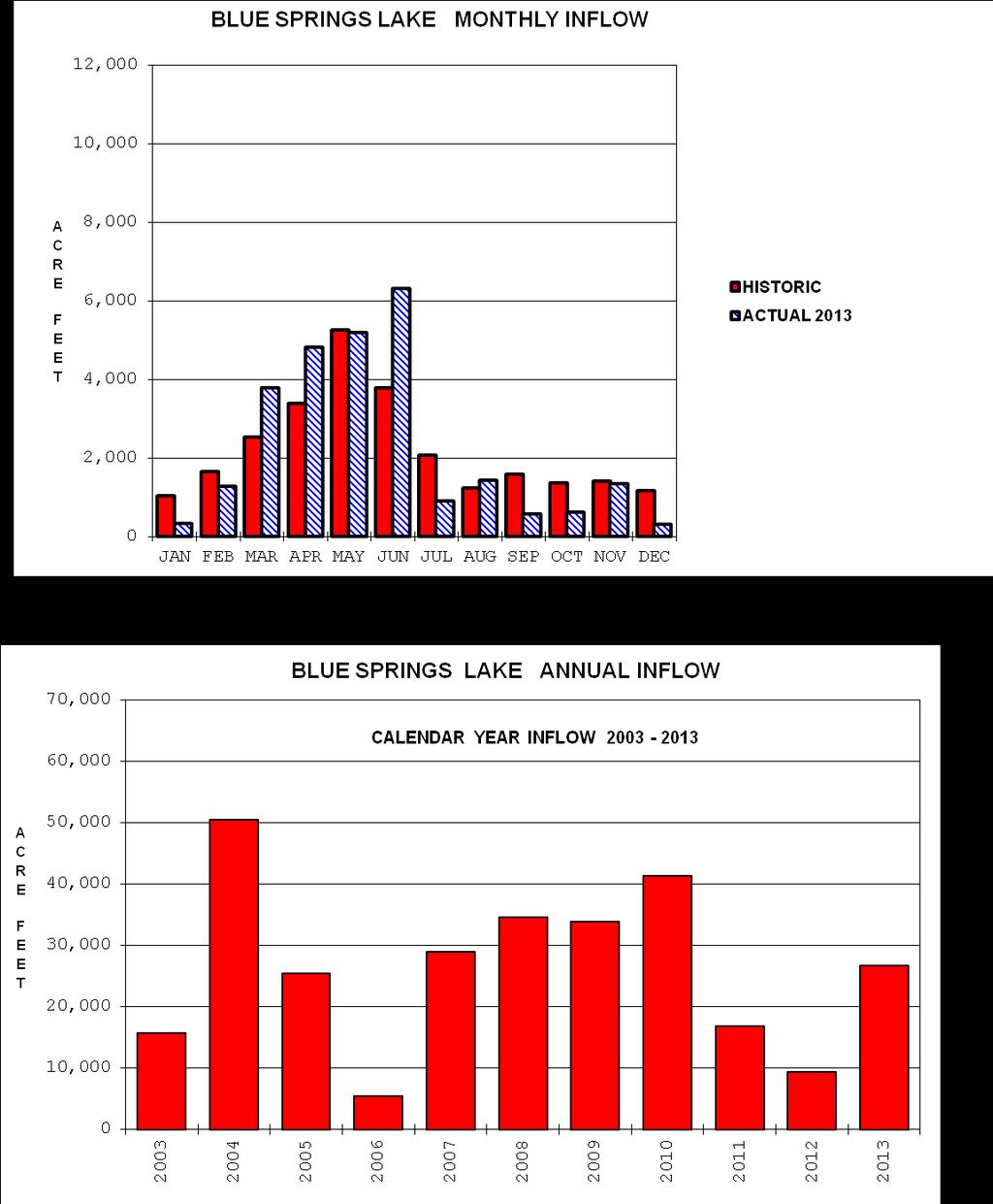
35
36 CLINTON LAKE 2013 REGULATION A 10-YEAR POOL ELEVATION HYDROGRAPH IS SHOWN BELOW WITH THE CURRENT REPORTING PERIOD EXPANDED FOR READING EASE. Pool Elevation, ft. msl. Starting Ending Jan Dec Jun Dec May Aug 89 Daily Inflow 2,600 1 Jun 13 Report Inflow and Outflow Total Inflow Acre Feet 34, Jul 13 Daily Outflow Daily Outflow 9 14 Mar 13 Outflows are those to river only. release is 7 to 21 cfs. Releases cut to 0 for maintenance, inspections.

37
38 HARLAN COUNTY LAKE 2013 REGULATION A 10-YEAR POOL ELEVATION HYDROGRAPH IS SHOWN BELOW WITH THE CURRENT REPORTING PERIOD EXPANDED FOR READING EASE. Pool Elevation, ft. msl. Starting Ending Jan Dec Jun Dec Apr Dec 04 Daily Inflow May 13 Report Inflow and Outflow Total Inflow Acre Feet Daily Outflow 48, May 13 Daily Outflow 0 Many Days Max daily outflow to river normally occurs as part of normal releases for irrigation. No minimum release requirement.

39
40 HARRY S TRUMAN RESERVOIR 2013 REGULATION A 10-YEAR POOL ELEVATION HYDROGRAPH IS SHOWN BELOW WITH THE CURRENT REPORTING PERIOD EXPANDED FOR READING EASE. Pool Elevation, ft. msl. Starting Ending Jan Dec Jun Jan Oct Apr 81 Report Inflow and Outflow Max Daily Inflow 80,000 2 Jun 13 No minimum release requirement. Total Inflow Acre Feet 7,187,612 31, May 13 Daily Outflow Daily Outflow 0 Many days

41
42 HILLSDALE LAKE 2013 REGULATION A 10-YEAR POOL ELEVATION HYDROGRAPH IS SHOWN BELOW WITH THE CURRENT REPORTING PERIOD EXPANDED FOR READING EASE. Pool Elevation, ft. msl. Starting Jan 13 Ending Dec Jun Jan Oct Nov 87 Daily Inflow 2,400 1 Jun 13 Report Inflow and Outflow Total Inflow Acre Feet 30, Jun 13 Daily Outflow Daily Outflow 3 Many days required release varies seasonally 3 to 24 cfs. Releases cut to 0 for maintenance and inspections.
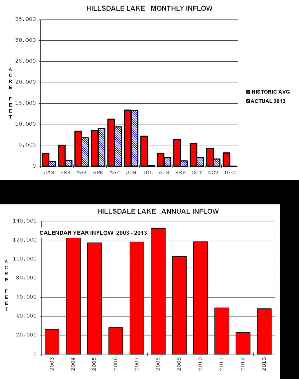
43
44 KANOPOLIS LAKE 2013 REGULATION A 10-YEAR POOL ELEVATION HYDROGRAPH IS SHOWN BELOW WITH THE CURRENT REPORTING PERIOD EXPANDED FOR READING EASE. Pool Elevation, ft. msl. Starting Ending Jan Dec Aug Jan Jul Dec 88 Daily Inflow 1, Jul 13 Report Inflow and Outflow Total Inflow Acre Feet 62, Aug 13 Daily Outflow Daily Outflow 5 31 Jul 13 Outflows are total from the gates and the uncontrolled notch. release varies seasonally 10 to 50 cfs.

45
46 LONG BRANCH LAKE 2013 REGULATION A 10-YEAR POOL ELEVATION HYDROGRAPH IS SHOWN BELOW WITH THE CURRENT REPORTING PERIOD EXPANDED FOR READING EASE. Pool Elevation, ft. msl. Starting Ending Jan Dec Apr Jan Jul Jan 01 Daily Inflow 4, May 13 Report Inflow and Outflow Total Inflow Acre Feet 104, Apr 13 Daily Outflow Daily Outflow 5 17 Sep 13 Listed outflows are total to the river from the gates and the uncontrolled notch. Min req release is normally 7 cfs.

47
48 LONGVIEW LAKE 2013 REGULATION A 10-YEAR POOL ELEVATION HYDROGRAPH IS SHOWN BELOW WITH THE CURRENT REPORTING PERIOD EXPANDED FOR READING EASE. Pool Elevation, ft. msl. Starting Jan 13 Ending Dec Jun Oct May Oct 13 Daily Inflow 2,200 1 Jun 13 Report Inflow and Outflow Total Inflow Acre Feet 37, Jun 13 Daily Outflow Daily Outflow Nov 13 Listed outflows are total to the river from the gate and the uncontrolled notch. required release is 8 cfs.

49
50 MELVERN LAKE 2013 REGULATION A 10-YEAR POOL ELEVATION HYDROGRAPH IS SHOWN BELOW WITH THE CURRENT REPORTING PERIOD EXPANDED FOR READING EASE. Pool Elevation, ft. msl. Starting Jan 2013 Ending Dec Aug Feb Jun Feb 92 Daily Inflow 1, Aug 13 Report Inflow and Outflow Total Inflow Acre Feet 45, All year Daily Outflow Daily Outflow 20 All year required release is 20 cfs. Releases reduced to 0 for maintenance and inspection periods.

51
52 MILFORD LAKE 2013 REGULATION A 10-YEAR POOL ELEVATION HYDROGRAPH IS SHOWN BELOW WITH THE CURRENT REPORTING PERIOD EXPANDED FOR READING EASE. Pool Elevation, ft. msl. Starting Ending Jan Dec Aug Jan Jul Jan 03 Report Inflow and Outflow Daily Inflow 11,000 4 Aug 13 required release is 25 cfs. Total Inflow Acre Feet 289,011 2, Aug 13 Daily Outflow Daily Outflow 25 Many days

53
54 PERRY LAKE 2013 REGULATION A 10-YEAR POOL ELEVATION HYDROGRAPH IS SHOWN BELOW WITH THE CURRENT REPORTING PERIOD EXPANDED FOR READING EASE. Pool Elevation, ft. msl. Starting Ending Jan Dec Jun Feb Jul Jan 03 Daily Inflow 17, May 13 Report Inflow and Outflow Total Inflow Acre Feet 211,573 6,000 7 Jun 13 Daily Outflow required release is 25 cfs. Releases reduced to 0 for maintenance and inspection periods. Daily Outflow 5 Many days

55
56 POMME DE TERRE LAKE 2013 REGULATION A 10-YEAR POOL ELEVATION HYDROGRAPH IS SHOWN BELOW WITH THE CURRENT REPORTING PERIOD EXPANDED FOR READING EASE. Pool Elevation, ft. msl. Starting Ending Jan Dec Apr Jan Sep Nov 10 Report Inflow and Outflow Daily Inflow 11,000 6 Aug 13 Total Inflow Acre Feet 619,956 3,500 2 May 13 Daily Outflow required release is 50 to 100 cfs, varying by season and pool level. Daily Outflow 50 Many days
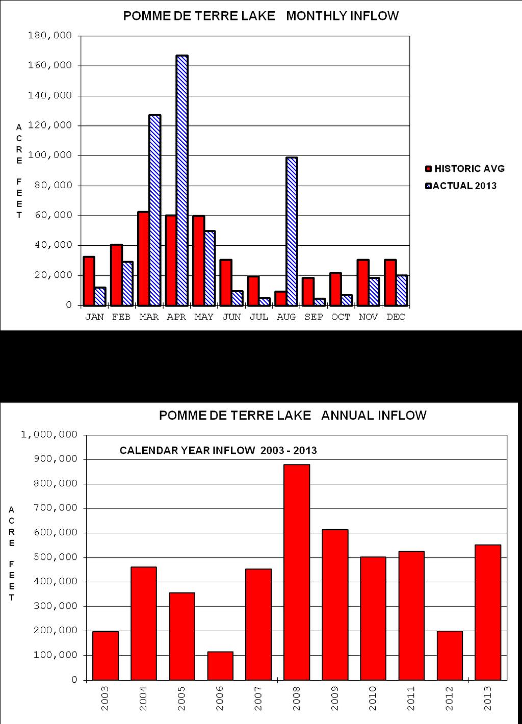
57
58 POMONA LAKE 2013 REGULATION A 10-YEAR POOL ELEVATION HYDROGRAPH IS SHOWN BELOW Pool Elevation, ft. msl. Starting Ending Jan Dec Jun Apr Jun Mar 67 Report Inflow and Outflow Daily Inflow 1, Jun 13 required release is 15 cfs. Total Inflow Acre Feet 31, All year Daily Outflow Daily Outflow 15 All year

59
60 RATHBUN LAKE 2013 REGULATION A 10-YEAR POOL ELEVATION HYDROGRAPH IS SHOWN BELOW WITH THE CURRENT REPORTING PERIOD EXPANDED FOR READING EASE. Pool Elevation, ft. msl. Starting Ending Jan Dec Jun Jan Jul Jan 95 Daily Inflow 25, Apr 13 Report Inflow and Outflow Total Inflow Acre Feet 382,750 2, Aug 13 Daily Outflow Daily Outflow 17 Many days Outlets include a fish hatchery pipe and service gate. required release varies with downstream needs.
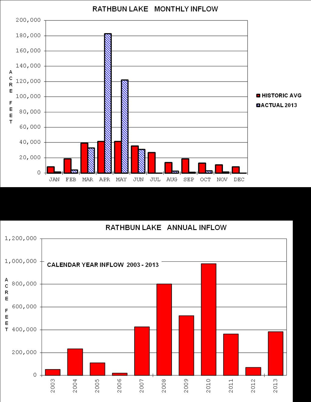
61
62 SMITHVILLE LAKE 2013 REGULATION A 10-YEAR POOL ELEVATION HYDROGRAPH IS SHOWN BELOW WITH THE CURRENT REPORTING PERIOD EXPANDED FOR READING EASE. Pool Elevation, ft. msl. Starting Ending Jan Dec Jun Jan Jul Jan 93 Daily Inflow 2, May 13 Report Inflow and Outflow Total Inflow Acre Feet Daily Outflow 53, Jun 13 Daily Outflow 8 Many days required release is 8 cfs. Releases cut to 0 during flooding and for maintenance and inspections.

63
64 STOCKTON LAKE 2013 REGULATION A 10-YEAR POOL ELEVATION HYDROGRAPH IS SHOWN BELOW WITH THE CURRENT REPORTING PERIOD EXPANDED FOR READING EASE. Pool Elevation, ft. msl. Starting Ending Jan Dec Aug Feb Apr Feb 77 Daily Inflow 20,000 5 Aug 13 Report Inflow and Outflow Total Inflow Acre Feet Daily Outflow 1,107,776 5, May 13 Listed outflows include turbine releases and spill to the river. required release is 40 cfs. Daily Outflow 40 Many Days
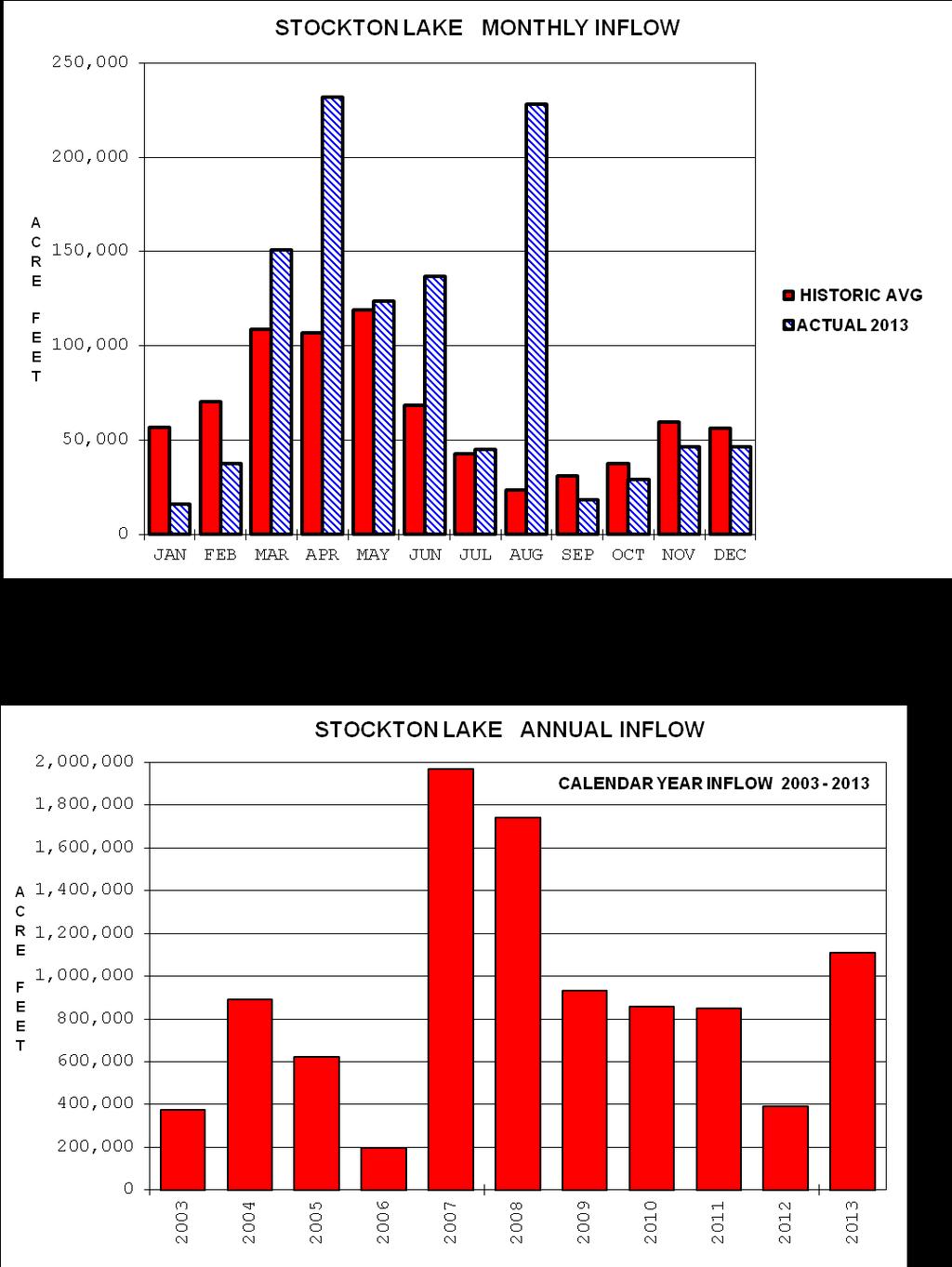
65
66 TUTTLE CREEK LAKE 2013 REGULATION A 10-YEAR POOL ELEVATION HYDROGRAPH IS SHOWN BELOW WITH THE CURRENT REPORTING PERIOD EXPANDED FOR READING EASE. Pool Elevation, ft. msl. Starting Ending Jan Dec Jun Jan Jul Jan 67 Daily Inflow 24, May 13 Report Inflow and Outflow Total Inflow Acre Feet 843,658 10,000 6 Jun 13 Daily Outflow Daily Outflow 100 Many days required release is 50 to 100 cfs. Releases may be cut to 0 for maintenance and inspection periods.

67
68 WILSON LAKE 2013 REGULATION A 10-YEAR POOL ELEVATION HYDROGRAPH IS SHOWN BELOW WITH THE CURRENT REPORTING PERIOD EXPANDED FOR READING EASE. Pool Elevation, ft. msl. Starting Ending Jan Dec Apr Dec Aug Dec 06 Daily Inflow Jul 13 Report Inflow and Outflow Total Inflow Acre Feet Daily Outflow 28, Many days Daily Outflow Dec 13 required release of 5-15 cfs varies seasonally. Releases cut to 0 for maintenance and inspections.

69
Kansas River Basin Model
 Kansas River Basin Model Edward Parker, P.E. KANSAS CITY DISTRICT NEBRASKA IOWA RATHBUN COLO. HARLAN COUNTY WILSON KANOPOLIS KANSAS TUTTLE CREEK MILFORD PERRY KANSAS CLINTON POMONA MELVERN SMITHVILLE R.
VII - WATER CONTROL PLAN
 VII - WATER CONTROL PLAN 7-01. General Objectives. Regulation of Saylorville Lake in conjunction with Lake Red Rock provides flood control benefits along both the Des Moines and Mississippi Rivers. Additionally,
OSAGE RIVER BASIN OPERATIONS WATER MANAGEMENT
 OSAGE RIVER BASIN OPERATIONS WATER MANAGEMENT An Overview of Basin Operations Water Management Section Hydrologic Engineering Branch Kansas City District Northwestern Division US Army Corps of Engineers
Missouri River Basin Water Management
 Missouri River Basin Water Management Spring 2011 Public Meetings April 12 th 11:00 a.m. Nebraska City, NE April 12 th 7:00 p.m. Fort Peck, MT April 13 th 1:00 p.m. Bismarck, ND April 13 th 7:00 p.m. Pierre,
DES MOINES RIVER RESERVOIRS WATER CONTROL PLAN UPDATES IOWA ASCE WATER RESOURCES DESIGN CONFERENCE
 DES MOINES RIVER RESERVOIRS WATER CONTROL PLAN UPDATES 237 237 237 217 217 217 200 200 200 0 0 0 163 163 163 131 132 122 80 119 27 252 174.59 110 135 120 112 92 56 IOWA ASCE WATER RESOURCES DESIGN CONFERENCE
Missouri River Basin Water Management
 Missouri River Basin Water Management Spring 2015 Public Meetings April 7 th April 7 th April 8 th April 9 th April 9 th 11:00 a.m. 6:00 p.m. 11:00 a.m. 11:00 a.m. 6:00 p.m. Pierre, SD Bismarck, ND Fort
US Army Corps of Engineers Kansas City District. A Dam Safety Study Involving Cascading Dam Failures
 A Dam Safety Study Involving Cascading Dam Failures Policy / Technical Issues How to account for the failure of other dams in the drainage basin How to account for the behavior of all basin dams acting
Missouri River Basin Water Management Spring 2013 Public Meetings
 Missouri River Basin Water Management Spring 2013 Public Meetings April 8 th April 9 th April 9 th April 10 th April 11 th 7:00 p.m. 11:00 a.m. 7:00 p.m. 11:00 a.m. 11:00 a.m. Nebraska City, NE Fort Peck,
Missouri River Basin Water Management
 Missouri River Basin Water Management US Army Corps of Engineers Low Water Update November 20, 2012 Jody Farhat, P.E. Chief, Missouri River Basin Water Management US Army Corps of Engineers Missouri River
Mark Twain Lake Water Control Manual Update
 Mark Twain Lake Water Control Manual Update Joan Stemler St. Louis District Water Control US Army Corps of Engineers WATER CONTOL PLAN Overall Objectives Project Purposes Flood Control Hydroelectric Power
Missouri River Basin Water Management Monthly Update
 Missouri River Basin Water Management Monthly Update Participating Agencies 255 255 255 237 237 237 0 0 0 217 217 217 163 163 163 200 200 200 131 132 122 239 65 53 80 119 27 National Oceanic and Atmospheric
MISSOURI RIVER BASIN WATER MANAGEMENT SPRING 2018 PUBLIC MEETINGS
 MISSOURI RIVER BASIN WATER MANAGEMENT SPRING 2018 PUBLIC MEETINGS April 17 th 10:00 a.m. Smithville, MO April 17 th 4:00 p.m. Omaha, NE April 18 th 10:00 a.m. Pierre, SD April 18 th 6:00 p.m. Bismarck,
4. Present Activities and Roles
 4. Present Activities and Roles The present missions, authorities, activities and roles of the various agencies involved with flood protection, floodplain management and flood-damage reduction are identified
Appendix I. Dworshak Operations
 Appendix I Dworshak Operations I. Introduction The 2008 Biological Opinion requires annual progress reports that describe actions taken to implement certain reasonable and prudent actions (RPA) for the
Missouri River Main Stem Reservoirs Annual Operating Plan. Missouri River Basin. Garrison North. Dakota. Oahe Big Bend. South.
 US Army Corps of Engineers Northwestern Division Missouri River Basin Water Management Division AOP 2000-2001 Missouri River Main Stem Reservoirs 2000-2001 Annual Operating Plan Missouri River Basin Fort
Missouri River Joint Information Center. Technical Analysis of Missouri River Mainstem Flood Control Storage
 Northwestern Division Missouri River Joint Information Center Technical Analysis of Missouri River Mainstem Flood Control Storage US Army Corps of Engineers Northwestern Division BG John R. McMahon Commander
RECORD OF DECISION MISSOURI RIVER MASTER WATER CONTROL MANUAL REVIEW AND UPDATE
 RECORD OF DECISION MISSOURI RIVER MASTER WATER CONTROL MANUAL REVIEW AND UPDATE I have reviewed the Missouri River Master Water Control Manual Review and Update Final Environmental Impact Statement (FEIS),
KANSAS CITY DISTRICT. Clinton Lake s Role in the Wakarusa Watershed. Samantha Jones, Park Manager Clinton & Hillsdale Lakes 5 November 2014
 KANSAS CITY DISTRICT Clinton Lake s Role in the Wakarusa Watershed Samantha Jones, Park Manager Clinton & Hillsdale Lakes 5 November 2014 US Army Corps of Engineers Clinton Lake Basic Information History/Purpose
2. CURRENT AND ALTERNATIVE WATER CONTROL PLANS
 2. CURRENT AND ALTERNATIVE WATER CONTROL PLANS This chapter describes the current Water Control Plan (CWCP) for operation of the Mainstem Reservoir System (Section 2.1) and the process of developing and
Lake Texoma Water Management Frequently Asked Questions (FAQs)
") Lake Texoma Water Management Frequently Asked Questions (FAQs) Q1: Why is Lake Texoma so low? A1: A combination of factors is contributing to the current lake level. Even though there was substantial rainfall
Lake Texoma Water Management Frequently Asked Questions (FAQs) Q1: Why is Lake Texoma so low? A1: A combination of factors is contributing to the current lake level. Even though there was substantial rainfall
Missouri River Mainstem Reservoir System Summary of September 2010 Flood Meetings
 Missouri River Mainstem Reservoir System Summary of September 2010 Flood Meetings Two public meetings regarding the summer 2010 flooding were held in Missouri on September 21, 2010. The purpose of the
Lyon Creek Cedar Way Stormwater Detention Dam Operation and Maintenance Manual
 Lyon Creek Cedar Way Stormwater Detention Dam Operation and Maintenance Manual Prepared by: Mike Shaw Stormwater Program Manager City of Mountlake Terrace January 2010 Section I General Information This
U.S. Army Corps of Engineers Reservoir Operations Maria Placht, Institute for Water Resources, USACE 49
 U.S. Army Corps of Engineers Reservoir Operations Maria Placht, Institute for Water Resources, USACE 49 Context The U.S. Army Corps of Engineers (the Corps) is responsible for a variety of water resourcerelated
Chapter VII. Falls Lake Project -- Water Control Plan
 Chapter VII. Falls Lake Project -- Water Control Plan (This January 2000 revision incorporates approved structural and guide curve changes made at Falls Dam per 1994 EA/1995 FONSI to address storage shortage.)
Reservoir Drought Operations
 Reservoir Drought Operations Kevin J. Landwehr, P.E., D.WRE Chief, Hydrology and Hydraulics Branch 4 March 2013 Purpose Awareness of Drought Contingency Plans 2012/13 Reservoir Operations Drought Management
Missouri River Recovery Program Shallow Water Habitat Accounting Summary Report. Kansas City District Omaha District 2014
 Missouri River Recovery Program Shallow Water Habitat Accounting Summary Report Kansas City District Omaha District 2014 THIS PAGE INTENTIONALLY LEFT BLANK Contents 1.0 Introduction... 1 1.1 Overview...
Summary of Flow and Water Quality Conditions Willamette Basin Science Review February 4-6, 2014
 Summary of Flow and Water Quality Conditions Willamette Basin Science Review February 4-6, 2014 Prepared by: U.S. Army Corps of Engineers, Portland District, January 2014 The following document summarizes
LAKE SHELBYVILLE MASTER PLAN KASKASKIA RIVER WATERSHED SHELBYVILLE ILLLINOIS
 LAKE SHELBYVILLE MASTER PLAN KASKASKIA RIVER WATERSHED SHELBYVILLE ILLLINOIS 1.1. PROJECT AUTHORIZATION CHAPTER 1 - INTRODUCTION Federal laws provide that land and water areas of Department of the Army
Spring Forecast Based Operations, Folsom Dam, California
 Spring Forecast Based Operations, Folsom Dam, California Paul E. Pugner, P.E. Chief, Water Management Section Sacramento District U.S. Army 1325 J Street, Room 1126 Sacramento, CA 95814-2922 Tel: (916)
M E M O R A N D U M S E P T E M B E R 2 8,
 M E M O R A N D U M S E P T E M B E R 2 8, 2 0 1 8 TO: FROM: BOARD OF DIRECTORS ANDREW MUELLER, GENERAL MANAGER PETER FLEMING, ESQ. GENERAL COUNSEL RAY TENNEY, P.E. & DON MEYER, P.E. SUBJECT: No Board
Welcome STEP 1: STEP 2: STEP 3:
 Welcome Displays are placed around the room. Each display focuses on federally authorized project purposes and particular issues related to the draft Alabama, Coosa, and Tallapoosa River Basin (ACT) Master
Missouri River Degradation (Lower 498 River Miles)
") BUILDING STRONG Missouri River Degradation (Lower 498 River Miles) for Mid-America Regional Council and U.S. Army Corps of Engineers Stakeholder Meeting March 5, 2009 BUILDING STRONG Reconnaissance Study
BUILDING STRONG Missouri River Degradation (Lower 498 River Miles) for Mid-America Regional Council and U.S. Army Corps of Engineers Stakeholder Meeting March 5, 2009 BUILDING STRONG Reconnaissance Study
Appendix I: Fixed-400,000 af Flood Storage Operation
 Appendix I: Fixed-400,000 af Flood Storage Operation 1.0 FIXED-400,000 AF FLOOD STORAGE OPERATION This operation set provides a comparison of operations before the SAFCA/Reclamation interim agreement in
Water Management and Diversion Accounting Activities Annual Report. (October 2013 September 2014)
") Water Management and Diversion Accounting Activities 2014 Annual Report (October 2013 September 2014) Hydrology and Hydraulics Section Design Branch Technical Services Division Chicago District October
Water Management and Diversion Accounting Activities 2014 Annual Report (October 2013 September 2014) Hydrology and Hydraulics Section Design Branch Technical Services Division Chicago District October
Review Plan U.S. Army Corps of Engineers Northwestern Division Kansas City District. Tuttle Creek Stilling Basin Wall Drain Repair Manhattan, Kansas
 Review Plan U.S. Army Corps of Engineers Northwestern Division Kansas City District Tuttle Creek Stilling Basin Wall Drain Repair Manhattan, Kansas March 2016 1. PURPOSE AND REQUIREMENTS 1.1 PURPOSE This
Old Document: Appendices 18 pages (1.84 MB) 8/9/13 5:22:06 PM -07'00'
 8/9/13 5:22:06 PM -07'00'") Summary 8/9/13 4:23:09 PM -07'00' Differences exist between documents. New Document: FinalEIS 58 pages (2.05 MB) 8/9/13 5:22:16 PM -07'00' Used to display results. Old Document: Appendices 18 pages (1.84
Summary 8/9/13 4:23:09 PM -07'00' Differences exist between documents. New Document: FinalEIS 58 pages (2.05 MB) 8/9/13 5:22:16 PM -07'00' Used to display results. Old Document: Appendices 18 pages (1.84
16 September Water Management Wilmington District. US Army Corps of Engineers BUILDING STRONG
 FALLS LAKE OPERATIONS UNRBA Board Meeting 16 September 2015 Water Management Wilmington District US Army Corps of Engineers Wilmington District 2 Water Management Mission 24/365 Operate Wilmington District
List of Appendices APPENDIX A: WY 2000 LAKE MICHIGAN DIVERSION ACCOUNTING REPORT APPENDIX B: WY 2001 LAKE MICHIGAN DIVERSION ACCOUNTING REPORT
 EXECUTIVE SUMMARY This document is the Water Year (WY) 2000 Annual Report of the Chicago District, U. S. Army Corps of Engineers activities in the monitoring and review of the accounting of Lake Michigan
Hydrology and Flooding
 Hydrology and Flooding Background The 1996 flood Between February 4, 1996 and February 9, 1996 the Nehalem reporting station received 28.9 inches of rain. Approximately 14 inches fell in one 48 hour period.
Status Report. Work to Date on the Development of the VARQ Flood Control Operation at Libby Dam and Hungry Horse Dam. January 1999.
 Status Report Work to Date on the Development of the VARQ Flood Control Operation at Libby Dam and Hungry Horse Dam January 1999 Section 3 29 JULY 1998 Prepared by U. S. Army Corps of Engineers Seattle
Elko Project Water Use Plan. Revised for Acceptance by the Comptroller of Water Rights
 Elko Project Water Use Plan Revised for Acceptance by the Comptroller of Water Rights 7 April 2005 B Elko Project Water Use Plan Revised for Acceptance by the Comptroller of Water Rights Elko Project
LAKE MICHIGAN DIVERSION ACCOUNTING WATER YEAR 2008 ANNUAL REPORT
 LAKE MICHIGAN DIVERSION ACCOUNTING WATER YEAR 2008 ANNUAL REPORT EXECUTIVE SUMMARY This document is the Water Year (WY) 2008 Annual Report of the Chicago District, U. S. Army Corps of Engineers activities
Water Supply Reallocation Workshop
 Water Supply Reallocation Workshop Determining Yield and Storage Requirement June 2, 2009 Tulsa, OK James Hathorn, Jr Redistribution of Water The function of a reservoir system is to redistribute the natural
INFLOW DESIGN FLOOD CONTROL SYSTEM PLAN 40 C.F.R. PART PLANT YATES ASH POND 3 (AP-3) GEORGIA POWER COMPANY
 GEORGIA POWER COMPANY") INFLOW DESIGN FLOOD CONTROL SYSTEM PLAN 40 C.F.R. PART 257.82 PLANT YATES ASH POND 3 (AP-3) GEORGIA POWER COMPANY EPA s Disposal of Coal Combustion Residuals from Electric Utilities Final Rule (40 C.F.R.
INFLOW DESIGN FLOOD CONTROL SYSTEM PLAN 40 C.F.R. PART 257.82 PLANT YATES ASH POND 3 (AP-3) GEORGIA POWER COMPANY EPA s Disposal of Coal Combustion Residuals from Electric Utilities Final Rule (40 C.F.R.
WATER SHORTAGE RESPONSE PLAN. Tacoma Water
 WATER SHORTAGE RESPONSE PLAN Tacoma Water March 2005 TACOMA WATER WATER SHORTAGE RESPONSE PLAN TABLE OF CONTENTS PAGE Purpose of the Water Shortage Response Plan 1 Droughts and System Emergencies 2 Previous
Farmington Dam Repurpose Project
 Farmington Dam Repurpose Project 2017 $158,100,000 to re-purpose the Farmington Dam from flood protection only to a long-term water storage facility that increases water supply reliability to the region.
Glades Reservoir Draft Environmental Impact Statement
 Glades Reservoir Draft Environmental Impact Statement Chapter 4 Environmental Consequences October 2015 4 ENVIRONMENTAL CONSEQUENCES 4.1 INTRODUCTION 4-1 4.1.1 Types and Definitions of Impacts 4-1 4.1.2
Colorado River Overview
 Colorado River Overview 16.5 million acre-feet (MAF) allocated annually 7.5 MAF to Upper Basin and 7.5 MAF plus an additional 1 MAF to Lower Basin 1944 Treaty grants 1.5 MAF to Mexico 13 to 14.5 MAF of
Harry S Truman Reservoir 1999 Water Quality Report
 Harry S Truman Reservoir 999 Water Quality Report. General. a. Project location. Truman Dam is located approximately. miles northwest of Warsaw, Missouri, at river mile. on the Osage River, a tributary
Continuous records for the Chariton River indicate that 2004 was an average water year, with total flow approximately equal to the average annual
 2004 Rathbun Report Iowa State University Limnology Laboratory John A. Downing, Ph.D. George Antoniou, Assistant Scientist For Rathbun Land and Water Alliance August 31, 2005 A. Tributaries Personnel of
Development of a Groundwater Monitoring Network for the Gateway Lake Rehabilitation Study
 Development of a Groundwater Monitoring Network for the Gateway Lake Rehabilitation Study Travis D. Yonts Hydraulic Engineer U.S. Army Corps of Engineers Omaha District Sheraton Hotel October 31, 2007
CORPS OF ENGINEERS. Water Resource Activities in the ACF Basin May 18, 2007
 CORPS OF ENGINEERS Water Resource Activities in the ACF Basin May 18, 2007 Mobile District River Basins Water Management Staff Supervisory Hydraulic Engineer 4 Hydraulic Engineers 1 Engineer/Co-op (Vacant)
Missouri River Bed Degradation Feasibility Study. Technical Report
 Missouri River Bed Degradation Feasibility Study Technical Report May 2017 This page is intentionally left blank. Missouri River Bed Degradation Feasibility Study Technical Report i This page is intentionally
EVALUATION - SECTION 404 OF THE CLEAN WATER ACT DISCHARGE OF SEDIMENTS FROM OR THROUGH A DAM
 EVALUATION - SECTION 404 OF THE CLEAN WATER ACT DISCHARGE OF SEDIMENTS FROM OR THROUGH A DAM U.S. ARMY CORPS OF ENGINEERS, NEW ENGLAND DISTRICT CONCORD, MA PROJECT: Northfield Brook Dam, Naugatuck River
Brian Rast, PE, CFM, PMP Lead Silver Jackets Coordinator, Kansas and Missouri Kris Lander, PE, CFM Hydrologist. June 4, 2015
 Presentation to the Association of State Floodplain Managers Interagency Partnering for Flood Forecast Inundation Maps Brian Rast, PE, CFM, PMP Lead Silver Jackets Coordinator, Kansas and Missouri Kris
Camp Far West Hydroelectric Project Relicensing
 Camp Far West Hydroelectric Project Relicensing Water Operations Model FERC Project No. 2997 July 16, 2018 Overview Project and South Sutter Water District overview Operations model Overview Model Updates
Friant Dam and Millerton Reservoir
 San Joaquin River Restoration Program Floodplain Management Association Presentation SJRRP Update Continued: Impacts from Subsidence April 18, 2013 1 Friant Dam and Millerton Reservoir Completed in 1942
Cokato Lake (86-263) Wright County. Hydrologic Investigation
 Wright County. Hydrologic Investigation") Cokato Lake (86-263) Wright County Hydrologic Investigation April 14, 2005 Cokato Lake (86-263) Wright County Hydrologic Investigation April 14, 2005 Problem Statement In recent years, heavy rainfall has
Cokato Lake (86-263) Wright County Hydrologic Investigation April 14, 2005 Cokato Lake (86-263) Wright County Hydrologic Investigation April 14, 2005 Problem Statement In recent years, heavy rainfall has
Appendix VI: Illustrative example
 Central Valley Hydrology Study (CVHS) Appendix VI: Illustrative example November 5, 2009 US Army Corps of Engineers, Sacramento District Prepared by: David Ford Consulting Engineers, Inc. Table of contents
PUBLIC NOTICE U.S. ARMY CORPS OF ENGINEERS
 ISSUE DATE: December 15, 2015 EXPIRATION DATE: January 15, 2016 PUBLIC NOTICE U.S. ARMY CORPS OF ENGINEERS Availability of Draft Environmental Assessment and Draft Finding of No Significant Impact REPLY
Project Information. Pursuant to Section 404 of the Clean Water Act (33 U.S. Code 1344), notice is hereby given that
, notice is hereby given that") US ARMY Corps Of Engineers Little Rock District JOINT PUBLIC NOTICE CORPS OF ENGINEERS STATE OF MISSOURI Application Number: SWL 2013-00260 Date: April 15, 2014 Comments Due: May 6, 2014 TO WHOM IT MAY
US ARMY Corps Of Engineers Little Rock District JOINT PUBLIC NOTICE CORPS OF ENGINEERS STATE OF MISSOURI Application Number: SWL 2013-00260 Date: April 15, 2014 Comments Due: May 6, 2014 TO WHOM IT MAY
DEAD RIVER DEAD RIVER HYDROELECTRIC PROJECT (P-10855)
") DEAD RIVER DEAD RIVER HYDROELECTRIC PROJECT (P-10855) A. SUMMARY 1. License Issued: October 4, 2002 2. Expiration: September 30, 2042 3. Waterway: Dead River 4. Capacity: 15.5 MW (megawatts) 5. Licensee:
DEAD RIVER DEAD RIVER HYDROELECTRIC PROJECT (P-10855) A. SUMMARY 1. License Issued: October 4, 2002 2. Expiration: September 30, 2042 3. Waterway: Dead River 4. Capacity: 15.5 MW (megawatts) 5. Licensee:
ANNUAL PROGRESS REPORT FOR 2014 ROGUE RIVER SPRING CHINOOK SALMON CONSERVATION PLAN ROGUE WATERSHED DISTRICT OREGON DEPARTMENT OF FISH AND WILDLIFE
 ANNUAL PROGRESS REPORT FOR 2014 ROGUE RIVER SPRING CHINOOK SALMON CONSERVATION PLAN ROGUE WATERSHED DISTRICT OREGON DEPARTMENT OF FISH AND WILDLIFE INTRODUCTION In September of 2007, the Oregon Fish and
EFFECTS OF ALTERNATIVES SELECTED FOR DETAILED ANALYSIS 7
 EFFECTS OF ALTERNATIVES SELECTED FOR DETAILED ANALYSIS 7 7.8 FLOOD CONTROL, INTERIOR DRAINAGE, AND GROUNDWATER IMPACTS The Mainstem Reservoir System dams, in conjunction with other flood control measures,
ASSESSMENT OF HIGH IRRIGATION USE STATE OF KANSAS
 ASSESSMENT OF HIGH IRRIGATION USE STATE OF KANSAS 1991 1999 By 21, reduce the number of irrigation points of diversion for which the amount of water applied in acre feet per acre exceeds an amount considered
LAKE MICHIGAN DIVERSION ACCOUNTING WATER YEAR 2012 ANNUAL REPORT
 LAKE MICHIGAN DIVERSION ACCOUNTING WATER YEAR 2012 ANNUAL REPORT EXECUTIVE SUMMARY This document is the Water Year (WY) 2012 Annual Report of the Chicago District, U. S. Army Corps of Engineers activities
EXHIBIT B PROJECT OPERATIONS
 EXHIBIT B PROJECT OPERATIONS HOLT HYDROELECTRIC PROJECT FERC NO. 2203 DRAFT LICENSE APPLICATION Alabama Power Company Birmingham, Alabama Prepared by: July 2012 EXHIBIT B PROJECT OPERATIONS HOLT HYDROELECTRIC
TECHNICAL MEMORANDUM Summerhill Rd Texarkana, Texas fax
 TECHNICAL MEMORANDUM 5930 Summerhill Rd Texarkana, Texas 75503 903 838 8533 fax 903 832 4700 TO: Becky Griffith, Jon Jarvis FROM Spandana Tummuri SUBJECT: Technical Memorandum on IP Analysis PROJECT: Sulphur
THE EFFECTS OF URBANIZATION ON THE MINGO CREEK WATERSHED
 THE EFFECTS OF URBANIZATION ON THE MINGO CREEK WATERSHED by Tim Marshall (presented at the Sixth Conference on Hydrometeorology in Indianapolis, IN, 1984) 1. INTRODUCTION Urbanization of flood plains presents
FINDINGS: Olsson used a three-step analysis strategy to develop a benefit cost ratio that would indicate the relative feasibility of this project.
 EXECUTIVE SUMMARY FINDINGS: Based on the results of this feasibility study, the Platte Republican Diversion Project would be cost-effective. With minimal improvements to the channel, and the existing bridge
Wood Canyon Emergent Wetland Project. City of Aliso Viejo 12 Journey, Suite 100 Aliso Viejo, CA 92656
 Wood Canyon Emergent Wetland Project City of Aliso Viejo 12 Journey, Suite 100 Aliso Viejo, CA 92656 Introduction Wood Canyon is located within Aliso and Wood Canyon Regional Park in southwest Orange County,
LAKE MICHIGAN DIVERSION ACCOUNTING WATER YEAR 2011 ANNUAL REPORT
 LAKE MICHIGAN DIVERSION ACCOUNTING WATER YEAR 2011 ANNUAL REPORT EXECUTIVE SUMMARY This document is the Water Year (WY) 2011 Annual Report of the Chicago District, U. S. Army Corps of Engineers activities
Warm Springs Hydro LLC 5203 South 11 th East Idaho Falls, ID
 Warm Springs Hydro LLC 5203 South 11 th East Idaho Falls, ID 83404 208-522-8069 ted@tsorenson.net September 26, 2013 Elizabeth A.O. Moats Oregon Department of Fish and Wildlife 107 20 th Street La Grande,
Chapter 6 Erosion & Stormwater Study Team
 Chapter 6 Erosion & Stormwater Study Team Objective How do we stabilize the Las Vegas Wash environment to most effectively reduce erosion and enhance wetlands? Introduction The Las Vegas Wash (Wash) has
The Colorado River Cooperative Agreement 1
 The Colorado River Cooperative Agreement 1 April 28, 2011 Introduction The Colorado River Cooperative Agreement is the product of five years of mediated negotiations. The negotiations were triggered by
Distributed Storage Alternative Screening Analysis February 17, 2015
 Distributed Storage Alternative Screening Analysis February 17, 2015 Executive Summary The Distributed Storage Alternative (DSA) was conceptualized during the public comment and alternative screening process
INITIAL HAZARD POTENTIAL CLASSIFICATION ASSESSMENT REPORT
 INITIAL HAZARD POTENTIAL CLASSIFICATION ASSESSMENT REPORT Lower AQC Impoundment Kansas City Power & Light Company La Cygne Generating Station File No. 27216294.00 Prepared by: SCS ENGINEERS 7311 West 130th
ANNUAL PLATTE RIVER SURFACE WATER FLOW SUMMARY
 ANNUAL PLATTE RIVER SURFACE WATER FLOW SUMMARY 4/3/213 Platte River Recovery Implementation Program 213 ANNUAL SURFACE WATER FLOW SUMMARY DRAFT Prepared by staff of the Platte River Recovery Implementation
Manhattan Levee Section 216 Feasibility Study Public Workshop 17Apr13 Manhattan Kansas
 Manhattan Levee Section 216 Feasibility Study Public Workshop 17Apr13 Manhattan Kansas Tuttle Creek Dam and Lake Kansas City District Project Development Team Manhattan, KS US Army Corps of Engineers 1
AQUATIC PLANT MANAGEMENT PLAN FOR U.S. ARMY CORPS OF ENGINEERS, SAVANNAH DISTRICT WATER RESOURCES PROJECTS SOUTH CAROLINA AND GEORGIA
 AQUATIC PLANT MANAGEMENT PLAN FOR U.S. ARMY CORPS OF ENGINEERS, SAVANNAH DISTRICT WATER RESOURCES PROJECTS SOUTH CAROLINA AND GEORGIA Appendix A CY 2014 Update Annual Aquatic Plant Treatment Plan and Summary
Appendix P. U.S. Fish and Wildlife Service Planning Aid Letter
 Appendix P U.S. Fish and Wildlife Service Planning Aid Letter This page is intentionally left blank. United States Department of the Interior FISH AND WILDLIFE SERVICE Missouri Ecological Services Field
USACE LEVEE AND DAM SAFETY PROGRAM AND ISSUES
 USACE LEVEE AND DAM SAFETY PROGRAM AND ISSUES 237 237 237 217 217 217 200 200 200 80 119 27 252 174.59 1 255 255 255 0 0 0 163 163 163 131 132 122 239 65 53 110 135 120 112 92 56 62 102 130 102 56 48 130
AMERICAN ELECTRIC POWER (SWEPCO)
") 2016 DAM & DIKE INSPECTION REPORT ASH PONDS GERS-16-163 WELSH POWER PLANT AMERICAN ELECTRIC POWER (SWEPCO) CASON, TEXAS NATIONAL INVENTORY NO. TX4357 PREPARED BY GEOTECHNICAL ENGINEERING AEP SERVICE CORPORATION
2016 DAM & DIKE INSPECTION REPORT ASH PONDS GERS-16-163 WELSH POWER PLANT AMERICAN ELECTRIC POWER (SWEPCO) CASON, TEXAS NATIONAL INVENTORY NO. TX4357 PREPARED BY GEOTECHNICAL ENGINEERING AEP SERVICE CORPORATION
To: From: Date: Subject: Sherwood Lakes Drainage Alternatives Analysis 1
 To: From: The City of Virginia Beach Lewis White and Rachael Johnson on behalf of WSP Date: June 6, 2017 Subject: s Drainage Alternatives Analysis This memorandum represents the summary of findings from
Reservoir Operation Constraints and Opportunities, from the perspective of the Bureau of Reclamation
 Reservoir Operation Constraints and Opportunities, from the perspective of the Bureau of Reclamation Presented at: Institutional Constraints to Water Management in New Mexico Albuquerque, New Mexico May
CHAPTER 3 FLOOD RELATED STUDIES
 CHAPTER 3 FLOOD RELATED STUDIES Although the area has experienced regular flooding there have been few formal flood studies until more recently. There are a number of water quality studies in the basins.
2017 Lake Hartwell Association
 2017 Lake Hartwell Association By Stan Simpson Water Manager/Civil Engineer Savannah District 14 October 2017 Trusted Partners Delivering Value, Today and Tomorrow CHARLESTON JACKSONVILLE MOBILE SAVANNAH
Grand County Mitigation and Enhancement Coordination Plan
 Moffat Collection System Project Grand County Mitigation and Enhancement Coordination Plan February 13, 2014 Introduction The Moffat Collection System Project is an enlargement of Gross Reservoir in Boulder
Lower San Joaquin River Feasibility Study PLAN FORMULATION ADDENDUM
 PLAN FORMULATION ADDENDUM Non-Structural Measure Descriptions Elevate Critical Infrastructure This measure would raise at-risk critical structures above the design inundation level. Elevation would be
Office, District Engineer, Seattle District, Corps of Engineers, 4735 East Marginal Way, Seattle 4, Washington
 800.2251 (Seattle Power Proj- Skagit River) 56 MPSGP Subject: Flood Control Requirement and Operating Procedure for Ross Reservoir, Skagit River, Wash. RHG/bg 4th Ind. 14 AUG 1953 13 August 1953 Office,
ANNUAL PROGRESS REPORT FOR 2015 ROGUE RIVER SPRING CHINOOK SALMON CONSERVATION PLAN ROGUE WATERSHED DISTRICT OREGON DEPARTMENT OF FISH AND WILDLIFE
 ANNUAL PROGRESS REPORT FOR 2015 ROGUE RIVER SPRING CHINOOK SALMON CONSERVATION PLAN ROGUE WATERSHED DISTRICT OREGON DEPARTMENT OF FISH AND WILDLIFE INTRODUCTION In September of 2007, the Oregon Fish and
All Actions Above Gavins Point Dam Least Tern and Piping Plover
 All Actions Above Gavins Point Dam Least Tern and Piping Plover Activity Sub Activity Stressor Likelihood of least tern and piping plover distribution (by life stage) in the action area and project footprint
LESLIE JAMES EXECUTIVE DIRECTOR COLORADO RIVER ENERGY DISTRIBUTORS ASSOCIATION (CREDA)
") LESLIE JAMES EXECUTIVE DIRECTOR COLORADO RIVER ENERGY DISTRIBUTORS ASSOCIATION (CREDA) TESTIMONY ON H.R. 1719 ENDANGERED SPECIES COMPLIANCE AND TRANSPARENCY ACT OF 2011 SEPTEMBER 22, 2011 Mr. Chairman,
LESLIE JAMES EXECUTIVE DIRECTOR COLORADO RIVER ENERGY DISTRIBUTORS ASSOCIATION (CREDA) TESTIMONY ON H.R. 1719 ENDANGERED SPECIES COMPLIANCE AND TRANSPARENCY ACT OF 2011 SEPTEMBER 22, 2011 Mr. Chairman,
Where in the Draft FR/EIS can I Find?
 Wildlife Preble s Meadow Jumping Mouse Discussion of Species & Habitat: pp. 3-63 3-64 Habitat in Chatfield Project Area: Fig 3-12, p. 3-65 Habitat in Reallocation Study Area: Fig 3-13, p. 3-67 Habitat
This is a digital document from the collections of the Wyoming Water Resources Data System (WRDS) Library.
 Library.") This is a digital document from the collections of the Wyoming Water Resources Data System (WRDS) Library. For additional information about this document and the document conversion process, please contact
This is a digital document from the collections of the Wyoming Water Resources Data System (WRDS) Library. For additional information about this document and the document conversion process, please contact
NEW CASTLE CONSERVATION DISTRICT. through. (Name of Municipality) PLAN REVIEW APPLICATION DRAINAGE, STORMWATER MANAGEMENT, EROSION & SEDIMENT CONTROL
 PLAN REVIEW APPLICATION DRAINAGE, STORMWATER MANAGEMENT, EROSION & SEDIMENT CONTROL") NEW CASTLE CONSERVATION DISTRICT through (Name of Municipality) PLAN REVIEW APPLICATION DRAINAGE, STORMWATER MANAGEMENT, EROSION & SEDIMENT CONTROL Office use only: Received by Municipality: Received by
NEW CASTLE CONSERVATION DISTRICT through (Name of Municipality) PLAN REVIEW APPLICATION DRAINAGE, STORMWATER MANAGEMENT, EROSION & SEDIMENT CONTROL Office use only: Received by Municipality: Received by
Prepared by: PacifiCorp 825 NE Multnomah Street Portland, OR 97232
 Wallowa Falls Hydroelectric Project (FERC No. P-308) Grande Ronde River Basin Wallowa County, Oregon June 2, 2017 Prepared by: PacifiCorp 825 NE Multnomah Street Portland, OR 97232 Table of Contents 1.0
2017 ANNUAL REPORT. House Bill 1437 Agricultural Water Conservation Program
 2017 ANNUAL REPORT House Bill 1437 Agricultural Water Conservation Program LCRA Board of Directors Timothy Timmerman, Chair Thomas Michael Martine, Vice Chair Steve K. Balas, Secretary Lori A. Berger Stephen
FERC Relicensing of Hawks Nest Project (FERC NO. 2512) Glen Ferris Project (FERC NO )
 Glen Ferris Project (FERC NO )") Brookfield Renewable Energy Group Focusing on Renewable Power Generation FERC Relicensing of Hawks Nest Project (FERC NO. 2512) Glen Ferris Project (FERC NO. 14439) October 2012 HAWKS NEST PROJECT (FERC
Brookfield Renewable Energy Group Focusing on Renewable Power Generation FERC Relicensing of Hawks Nest Project (FERC NO. 2512) Glen Ferris Project (FERC NO. 14439) October 2012 HAWKS NEST PROJECT (FERC
LAKE CHEMUNG GENOA TOWNSHIP LIVINGSTON COUNTY, MICHIGAN STORM DRAIN AND TRIBUTARY STUDY. Prepared for:
 LAKE CHEMUNG GENOA TOWNSHIP LIVINGSTON COUNTY, MICHIGAN STORM DRAIN AND TRIBUTARY STUDY Prepared for: Lake Chemung Riparian Association c/o 1125 Sunrise Park Drive Howell, MI 48843 Prepared by: Progressive