LANDSCAPE SCALE PLANNING: INNOVATIVE TOOLS USED BY MD SHA AND TX DOT
|
|
|
- Amber McCoy
- 6 years ago
- Views:
Transcription

1 LANDSCAPE SCALE PLANNING: INNOVATIVE TOOLS USED BY MD SHA AND TX DOT AASHTO TIG Project Texas Department of Transportation Maryland State Highway Administration Sandy Hertz Deputy Director, Office of Environmental Design Maryland State Highway Administration June 9, 2010
2 The Rules Have Changed April 2008 Final Compensatory Mitigation Rule Increased transparency and improved performance Set clear science-based and results-oriented standards nationwide Encourage watershed-based decisions Continued emphasis on avoidance and minimization
3 Overview AASHTO TIG Environmental Planning GIS Tools Lead States Team Texas and Maryland Texas DOT GIS Screening Tool Maryland SHA s Green Infrastructure Assessment and Approach


4 Texas: A big state with both rural and urban populations Land Area Million Acres Ranks 2 nd 84% Private Land Estimated Population 25.4 Million Ranks 2 nd By Million


5 Environmental Planning Tools TxDOT has acquired GIS tools from U.S. EPA: Texas Ecological Assessment Protocol (TEAP) GIS Screening Tool NEPAssist


6 What is TEAP? Composite: identifies important ecological resources in each ecoregion across Texas

7 What is GISST?
8 GIS-ST Calculation Example % Wildlife Percentage of cell that is identified as wildlife habitat In general, a score of 5 Rank Value indicates a high degree of 1 < 20% of the grid cell concern and a 1 indicates a low degree of % of the grid cell concern % of the grid cell % of the grid cell 5 > 50% of the grid cell

9 What is NEPAssist?

10 Upload shapefiles Measure distances Add remote services Digitize project location Get analysis of project area
11 Comparison NEPAssist vs. GISST Report

12 Alternative 1: GISST Report Direct Impacts


13 Alternative 2: GISST Report Direct Impacts
14 GISST Database Comparison of Alternatives Corridor Alternative Number of facilities score % Wildlife % Agriculture % Wetlands stream density % 100 year floodplain % 500 year floodplain Land Use Ranking

15 Texas Case Study Interstate 69 Project Planning and Development Location Environmental Study GIS tools used
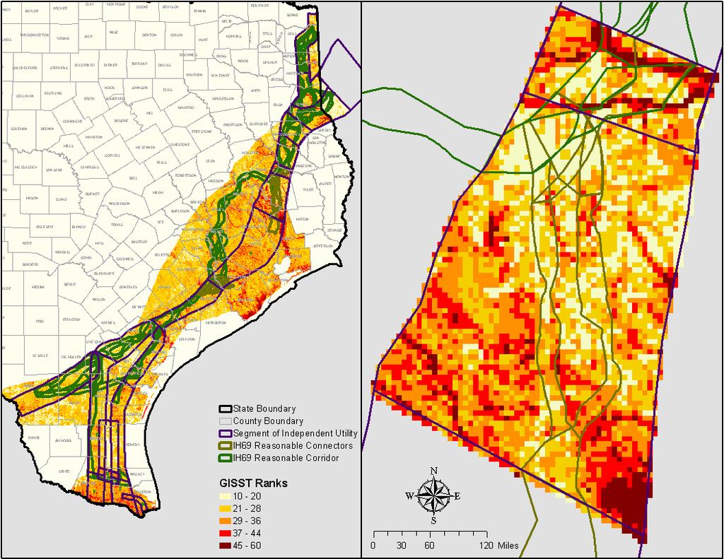
16 GIS-ST Cumulative


17 Current and Future Efforts to Enhance GIS Tools Expansion of TEAP to a South Central US Regional Ecological Assessment Protocol (REAP) Recalculation to a 0.25 km2 grid more granular grid for medium size project level analysis Recalculations using new land cover data GISST Incorporation into NEPAssist Website
18 Maryland: A small state with many people Land Area 6.2 Million Acres Ranks 42 nd 20.8% developed 21.9% protected Population 5.6 Million Ranks 19 th By Million


19 Green Infrastructure Strategically planned and managed networks of natural lands, working landscapes and other open spaces that conserve ecosystem functions, and provide associated benefits to human populations Jane Hawkey, Jane Thomas, IAN Image Library (
20 Maryland s Green Infrastructure Assessment Selection of Ecological Components Strive to include full range of ecosystem elements vs. single species focus Multidisciplinary Effort DNR biologists Aquatics, Forests, Wildlife and Heritage Scientific Community Limited to features with GIS data available statewide Unique Wetland Habitats Steep Slopes Colonial Waterbird Nesting Locations Large Blocks of Contiguous Forest Habitat Protection Areas Ecological Features Large Contiguous Wetland Complexes Rare, Threatened, and Endangered Species Sites Riparian Areas Waterfowl Concentration and Staging Areas Natural Heritage Areas Existing Protected Areas

21 Maryland s Green Infrastructure Assessment Composite of Ecological Features
22 Green Infrastructure Approach a process that promotes a systematic and strategic approach to land conservation at the national, state, regional, and local scales encouraging land use planning and practices that are good for nature and people. Mark A. Benedict, Edward T. McMahon, 2006, Green Infrastructure

23 The Green Network Core Core Hub Core Core Hub Core Core Core Core Hub Core Core Cores Hubs Corridors are groupings unfragmented link hubs and of core allow natural areas animal, cover bounded water, with by at seed major least and 100 roads pollen acres or of unsuitable movement interior conditions. land between cover hubs


24 GI Gaps Repairing the Network and Restoring the Chesapeake Bay Undeveloped Gaps may be suitable for restoration activities Restoration benefits achieved at local and regional scales Hub and Corridor rankings can be used to prioritize restoration sites
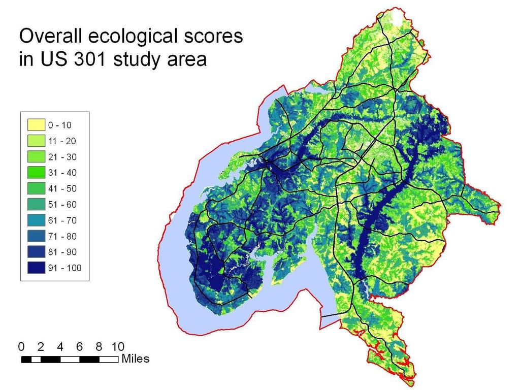
25 GREEN INFRASTRUCTURE STRATEGIC APPROACH US 301 Case Study


26 US 301 Waldorf Area Transportation Improvements Project Maryland State Highway Administration Partners:

27


28 US 301 Core Areas

29 US 301 Project Overall Ecological Score Scale Variable Scale weight Variable weight within scale Total weight Core area/site Hub area ESA area Area of mature interior forest Area of unimpacted wetlands Length of core streams Maximum depth of core or site Distance to major roads Distance to development Proximity index Connectivity index Hub ESA area Area of mature interior forest Area of unimpacted wetlands Length of core streams Maximum depth of hub Distance to major roads Distance to development Proximity index Connectivity index Corridor Average rank of linked hubs Number of hubs linked Major road crossings without bridges digit watershed Anadromous fish spawning habitat use Percent core streams in watershed digit watershed Stronghold watershed (Tier 1/Tier 2/neither) Mean combined IBI score Grid cell (36 m 2 ) ESA presence and rank Ecological Community Group rank Forest maturity Wetland condition and proximity Proximity to core streams Proximity to water Distance to edge of forest, wetland, or water Distance to development TOTAL
30

31 Hub and Corridor Network Environmental Stewardship Needs Environmental Stewardship Activities Conservation / Preservation 60% Restoration / Creation 18% Management Actions 11% Recreation / Public Access to Open Space 11% Priority Natural Resources Forests 22% Streams and Aquatic Resources 19% Wetlands 17% Marine Fisheries 10% Species Habitat 11% Passive Recreation Areas 5% Historic/Archeological 6% Agriculture 9%
32 US 301 NEXT STEPS Field truth opportunities Select sites Establish protocols for future transportation projects
33 Project Selection Methods Government agencies and NGOs typically use a rank-based approach to select projects for implementation. The rank-based approach focuses only on the benefits of a project without considering the project s cost, which can result in highly inefficient investments. It ignores potential good buys that offer high quality (environmental benefits) at a significantly lower cost. The use of optimization in project selection provides a means to extend the reach and effectiveness of environmental efforts. 33
34 % Total Acres. Differences in Selection Models 100% 90% 80% OM Rank Based 45 degree line 70% 60% 50% 40% 30% 20% 10% 0% 0% 10% 20% 30% 40% 50% 60% 70% 80% 90% 100% % Total Costs
35 Project Selection Using Optimization Optimization Decision Support Tool requirements Opportunities (Environmental stewardship projects) Benefits (Project benefit scoring/ranking) Costs (Financial investment required to achieve benefits) Constraints (Budget scenario, other decision constraints) Tool benefits Easy to use (Excel interface) Flexible (answer multiple planning questions) Ability to run multiple scenarios (sensitivity analysis) Potential to extend limited funds for compensatory mitigation and environmental stewardship 35
36 Why Use These Tools? Compliance with existing regulations Defensible decisions Accelerated project delivery Improved resource protection Sustainable planning Supports a watershed approach Scalable solution Can be integrated with existing GIS data

37 Why Use These Tools? Because we can t afford not to.
38 Contact Information: Texas Department of Transportation Troy Sykes Maya Coleman Maryland State Highway Administration Sandy Hertz Greg Slater U.S. EPA, Region 6 Sharon Osowski osowski.sharon@epa.gov
Environment & Conservation Introduction
 Environment & Conservation Introduction Anacortes is blessed with an abundance of natural beauty. Residents identify marine shorelines, streams, lakes, forested areas, and other natural features as defining
A Freshwater Blueprint for Maritime Canada
 A Freshwater Blueprint for Maritime Canada Union of Nova Scotia Municipalities (UNSM) November 8 th, 2017 William Millar Aquatic Conservation Biologist william.millar@natureconservancy.ca Craig Smith Conservation
The Next Generation of Mitigation: Linking Current and Future Mitigation Programs with State Wildlife Action Plans and Other State and Regional Plans
 : Linking Current and Future Mitigation Programs with State Wildlife Action Plans and Other State and Regional Plans August 4, 2009 Jessica B. Wilkinson, James M. McElfish, Jr., and Rebecca Kihslinger
Duwamish Waterway Self Guided Tour: Turning Basin Number Three and Terminal 105 Aquatic Habitat Restoration Sites
 Duwamish Waterway Self Guided Tour: Turning Basin Number Three and Terminal 105 Aquatic Habitat Restoration Sites Text and illustrations in the following pages include: (1) summary information describing
Biological Uplift in Stream Restoration Projects. September 20, Presentation by: Wetlands and Waterways Program
 Biological Uplift in Stream Restoration Projects September 20, 2017 Presentation by: Wetlands and Waterways Program Integrated Water Planning Program Maryland Department of the Environment Wetlands & Waterways
Public Notice. Applicant: City of Dallas Project No.: SWF Date: April 18, Name: Chandler Peter Phone Number:
 Public Notice Applicant: City of Dallas Project No.: SWF- 2014-00151 Date: April 18, 2014 The purpose of this public notice is to inform you of a proposal for work in which you might be interested. It
Green Infrastructure in the Transportation Sector
 Green Infrastructure in the Transportation Sector Transportation Research Board Webinar Mackenzie Schoonmaker Fred Wagner May 2015 What does GI mean for transportation organizations? Presenters Mackenzie
Chapter 10 Natural Environment
 Chapter 10 Natural Environment Existing Conditions The Natural Environment Element addresses the protection, conservation, preservation, and restoration of the natural resources the Bayview Ridge Subarea,
Chapter 13: Wildlife and Vegetation
 Chapter 13: Wildlife and Vegetation Introduction and Setting Nevada County contains an extremely wide range of plants, animals and habitat types. With topographic elevations ranging from 300 feet in the
Calculating Mitigation
 US Army Corps of Engineers Jacksonville District Calculating Mitigation Lift Loss 1 US Army Corps of Engineers Jacksonville District Under the U.S. Army Corps of Engineers Regulatory Program, mitigation
Quantifying the Benefits of Stream Restoration
 Quantifying the Benefits of Stream Restoration 10 th Annual GAFM Technical Conference, March 2016 Jarrod Karl, Hazen and Sawyer Presentation Outline Benefits of Stream Restoration The Watershed Approach
Wetland Jurisdictional Size Comparisons Multiple Jurisdictions Jurisdiction Name (Year Jurisdictional Wetland Size Notes
 1 Thurston County Planning Commission April 6, 2011 Meeting Wetland Jurisdictional Size Comparisons Multiple Jurisdictions Jurisdiction Name (Year Jurisdictional Wetland Size Notes Adopted/Amended) (SF
WATERSHED MANAGEMENT INITIATIVE: GOALS & IMPLEMENTATION OBJECTIVES, JULY 26, 1999
 WATERSHED MANAGEMENT INITIATIVE: GOALS & IMPLEMENTATION OBJECTIVES, JULY 26, 1999 The following table indicates the draft goals and objectives for the Santa Clara Basin WMI process. The overall objectives
DECISION MEMO. West Fork Blacktail Deer Creek Hardened Crossing
 Page 1 of 6 Background DECISION MEMO USDA Forest Service Madison Ranger District Madison County T12S, R4W, Section 30 The project is in the Gravelly Landscape, Snowcrest Recommended Wilderness Management
Environmental Information Worksheet
 Environmental Information Worksheet Water System Owner (Attach additional sheets if necessary) Needs and Alternatives Provide a brief narrative that describes: Current drinking water system needs. Project
Raritan River Basin. How to protect quality & quantity of water resources? Land Protection and Management to Protect Water Resources
 Land Protection and Management to Protect Water Resources New Jersey Water Supply Authority: Kathy Hale, Principal Watershed Protection Specialist (908) 685-0315 x228 khale@raritanbasin.org Jen Zhang,
Marcellus Shale Gas Development in Maryland: A Natural Resource Analysis
 Marcellus Shale Gas Development in Maryland: A Natural Resource Analysis Advisory Commission Meeting February 27, 2012 Garrett County Economic Development map Catherine McCall Balancing Natural Resources
Pacific Northwest Region, Forest Service Basin-scale Restoration Prioritization Process
 Pacific Northwest Region, Forest Service Basin-scale Restoration Prioritization Process Pacific Northwest Region U.S.D.A. Forest Service Dave Heller, Regional Fish Program Leader Bruce McCammon, Regional
Logical. Creating a Regional Decision Support System for the Houston-Galveston Region
 Logical Creating a Regional Decision Support System for the Houston-Galveston Region Table of Contents List of Tables and Figures...3 Executive Summary...4 1.0 Introduction...6 1.1 Environmental Resources...6
Hello my name is Joy Loughry and I am with the groundwater technical unit of the Minnesota department of natural resources. Today I am going to talk
 Hello my name is Joy Loughry and I am with the groundwater technical unit of the Minnesota department of natural resources. Today I am going to talk about how the state of Minnesota manages its Water resources
Nationwide Permit General Conditions
 Nationwide Permit General Conditions Note: To qualify for NWP authorization, the prospective permittee must comply with the following general conditions, as applicable, in addition to any regional or case-specific
South St. Vrain / Hall Meadows Restoration Planning August 20, 2015
 South St. Vrain / Hall Meadows Restoration Planning August 20, 2015 Agenda Introductions Purpose & Goals of Meeting Planning Area Master Plan Restoration Planning: Cost Estimates, Grants, Scope, Timeline
Oregon Spatial Analysis Project
 Oregon Spatial Analysis Project Oregon Department of Forestry June 2006 Table of Contents Executive Summary... 1 Introduction... 3 Background... 3 History of Forest Stewardship and Spatial Analysis Projects...
WILMINGTON DISTRICT US ARMY CORPS OF ENGINEERS REGULATORY DIVISION. US Army Corps of Engineers BUILDING STRONG
 WILMINGTON DISTRICT US ARMY CORPS OF ENGINEERS REGULATORY DIVISION US Army Corps of Engineers Organization The Wilmington District Regulatory Division consists of 4 field offices in Wilmington, Washington,
NDCEE. Ecosystem Banking Best Practices. Elizabeth Keysar, NDCEE/CTC. National Defense Center for Energy and Environment
 NDCEE Ecosystem Banking Best Practices DoD Executive Agent Office Office of the of the Assistant Assistant Secretary of the of Army the Army (Installations and and Environment) Elizabeth Keysar, NDCEE/CTC
Riparian Buffers and Stream Restoration
 Riparian Buffers and Stream Restoration Why focus on riparian areas? Link land and water on any given site and link landscapes together in a watershed Riparian corridors protect the circulatory system
Eco-logical: Integrating Green Infrastructure and Regional Transportation Planning
 Eco-logical: Integrating Green Infrastructure and Regional Transportation Planning Thomas Jefferson Planning District Commission 401 E. Water Street Charlottesville, Virginia 22902 (434) 979-7310 www.tjpdc.org
CHESAPEAKE BAY COMPREHENSIVE WATER RESOURCES AND RESTORATION PLAN
 CHESAPEAKE BAY COMPREHENSIVE WATER RESOURCES AND 255 255 255 237 237 237 0 0 0 217 217 217 163 163 163 200 200 200 131 132 122 239 65 53 80 119 27 RESTORATION PLAN 110 135 120 252 174.59 112 92 56 62 102
Dang Thi Tuoi Biodiversity Conservation Agency (BCA) Ministry of Natural Resources and Environment of Vietnam (MONRE)
 Ministry of Natural Resources and Environment of Vietnam (MONRE)") Dang Thi Tuoi Biodiversity Conservation Agency (BCA) Ministry of Natural Resources and Environment of Vietnam (MONRE) Main Contents: 1. Roles of biodiversity in Vietnam 2. Threats to biodiversity in Vietnam
Dang Thi Tuoi Biodiversity Conservation Agency (BCA) Ministry of Natural Resources and Environment of Vietnam (MONRE) Main Contents: 1. Roles of biodiversity in Vietnam 2. Threats to biodiversity in Vietnam
Sustainable Transportation
 Sustainable Transportation Stephanie Hickman 5 April 2011 What I ll talk about Definitions Principles Programs and Initiatives References Sustainability Providing an acceptable quality of life for today
Regulatory Guidance Letter 93-02
 Regulatory Guidance Letter 93-02 SUBJECT: Guidance on Flexibility of the 404(b)(1) Guidelines and Mitigation Banking DATE: August 23, 1993 EXPIRES: December 31, 1998 1. Enclosed are two guidance documents
Status of New Hampshire s Conservation Lands
 Status of New Hampshire s Conservation Lands SB 388 and beyond April 2015 Purpose of the SB 388 Study Committee Current composition of conservation lands: Acreage & percentage resource protection Geographic
Instructions for the South Pacific Division Nationwide Permit Pre- Construction Notification (PCN):
:") This PCN integrates the requirements of the U.S. Army Corps of Engineers (Corps) Nationwide Permit Program within the South Pacific Division (SPD), including the Albuquerque, Los Angeles, San Francisco,
This PCN integrates the requirements of the U.S. Army Corps of Engineers (Corps) Nationwide Permit Program within the South Pacific Division (SPD), including the Albuquerque, Los Angeles, San Francisco,
STREAM AND BUFFER AREA PROTECTION/RESTORATION
 STREAM AND BUFFER AREA PROTECTION/RESTORATION AMENDMENT OPTIONS TO STRENGTHEN POLICY IN HEADWATERS AREAS DRAFT SUBSEQUENT TO THE JANUARY 25, 2007 MEETING OF THE PLANNING COMMISSION ENVIRONMENT COMMITTEE
Terrestrial Fish and Wildlife Habitat Management
 Terrestrial Fish and Wildlife Habitat Management Tier 2 Worksheet Community Environmental Management 265 Acknowledgements The New York State Soil and Water Conservation Committee and Department of Environmental
From the thousands of miles of coastal shoreline
 Water Resources VALUE OF OUR NATION S WATER RESOURCES From the thousands of miles of coastal shoreline and rivers to the lakes and wetlands that dot our nation s landscape, America is fortunate to have
Where Funds are Spent
 Page 1 of 10 DNR FY 2014-15 Budget 2013 Legislative Session Where Funds are Spent The DNR is organized into seven operating divisions, or programs, for managing where funds are spent. The Divisions are
GAUTENG BIODIVERSITY GAP ANALYSIS
 GAUTENG BIODIVERSITY GAP ANALYSIS DEPARTMENT OF AGRICULTURE, CONSERVATION, ENVIRONMENT & LAND AFFAIRS Introduction Project aim Approach to project Data collection Threat layers Data analysis Time frame
Ecosystem Service Tradeoffs in the Implementation of the Bay TMDL
 Ecosystem Service Tradeoffs in the Implementation of the Bay TMDL Lisa A. Wainger 1 and Jay Messer 2 1 University of Maryland Center for Environmental Science 2 Retired; formerly of US EPA Office of Research
PLANT AND ANIMAL DIVERSITY
 by the planning rule team as of. These ideas are for discussion purposes and do not What we want to achieve PLANT AND ANIMAL DIVERSITY The Forest Service is committed to protecting species and sustaining
POLICY FOR NATURAL RESOURCE MANAGEMENT AREAS
 POLICY FOR NATURAL RESOURCE MANAGEMENT AREAS I. POLICY STATEMENT Auburn University's (the University's) "Policy for Natural Resource Management Areas" implements the Campus Master Plan Land Use Element
Chesapeake Bay Report Card 2016
 hesapeake Bay Report ard 216 University of Maryland enter for Environmental Science Fun for you and your family Stewardship is defined as the responsible oversight and protection of something considered
The Next Generation of Mitigation: Linking Current and Future Mitigation Programs with State Wildlife Action Plans and Other State and Regional Plans
 The Next Generation of Mitigation: Linking Current and Future Mitigation Programs with State Wildlife Action Plans and Other State and Regional Plans August 4, 2009 Jessica B. Wilkinson, James M. McElfish,
Chapter 4 Watershed Goals and Objectives
 Chapter 4 Watershed Goals and Objectives Eight (8) long-term watershed goals have been developed by the NEW Watershed Advisory Group (WAG) after consideration of discussions held during monthly watershed
UNITED STATES DEPARTMENT OF THE INTERIOR BUREAU OF LAND MANAGEMENT Washington, DC
 UNITED STATES DEPARTMENT OF THE INTERIOR BUREAU OF LAND MANAGEMENT Washington, DC 20240-0002 http://www.blm.gov In Reply Refer to: 1610, 1734, 4100, 4180, 6700 (230) P EMS TRANSMISSION Instruction Memorandum
Functional Uplift Based Stream Assessment & Restoration Design
 Functional Uplift Based Stream Assessment & Restoration Design Darcy K.L. Turner Senior Environmental Scientist, Biohabitats, Inc. (dturner@biohabitats.com) Christopher A. Streb, PE Ecological Engineer,
Learning to SWVM. SWVM v2.1 for WVDEP Date: August 20, US Army Corps of Engineers BUILDING STRONG
 Learning to SWVM SWVM v2.1 for WVDEP Date: August 20, 2013 US Army Corps of Engineers SWVM v1.0 Released by IRT via Joint PN Feb 1, 2010 SWVM v2.0 Released by IRT via Joint PN Feb 1, 2011 Revisions included:
Project Goals and Scoping
 Prepared for: Boulder County, Colorado Flood Planning & Preliminary Design Services for South St. Vrain Creek Restoration at Hall Ranch and Scoping May 24, 2016 Meeting with General Public In association
Natural Resource Management of Pipeline Infrastructure
 Natural Resource Management of Pipeline Infrastructure Dan Devlin Director, Bureau of Forestry www.dcnr.state.pa.us Connection between Pipelines & DCNR Commonwealth s forests Fragmentation or reduction
CHAPTER 2 WHAT ARE WE TRYING TO ACHIEVE?
 CHAPTER 2 WHAT ARE WE TRYING TO ACHIEVE? VISION After significant public outreach and coordination with numerous agencies, organizations, and individuals, Phase 1 established a vision for transportation
719 Griswold, Suite 820 Detroit, MI DANVERS POND DAM REMOVAL AND STREAM RESTORATION PROJECT
 Great Lakes Restoration Initiative Grant Final Report US EPA Grant GL 00E006 43 October, 2013 Valley Woods Wetland Southfield Lola Valley Grow Zone Wayne County Parks Venoy Park Grow Zone Wayne County
Conservation Assessment of the Neuse River Lowgrounds and Mill Creek Watersheds in Johnston County
 Conservation Assessment of the Neuse River Lowgrounds and Mill Creek Watersheds in Johnston County Prepared by Leigh Ann Cienek and Jon Scott Triangle Land Conservancy Funding provided by the NC Attorney
Emerging Trends in Ecological Offsets
 Emerging Trends in Ecological Offsets Citizens Advisory Council Meeting November 14, 2017 Agenda Overview of Ecological Offsets Market-based, generating offset products, at large scale Wetland/Stream Mitigation
CHAPTER 9 DISCUSSIONS, CONCLUSIONS, AND RECOMMENDATIONS
 CHAPTER 9 DISCUSSIONS, CONCLUSIONS, AND RECOMMENDATIONS This chapter summarizes the results of feasibility level investigations undertaken to identify solutions to the water and related land resource problems
HCP Development: Key Aspects of Conservation Planning
 Section 3. The Santa Clara Valley HCP/NCCP Key Issues and Examples from Other HCPs and NCCPs HCP Development: Key Aspects of Conservation Planning Planning Biology Economics Public Involvement Regulatory
Performance Standard 6 V2
 Introduction 1. Performance Standard 6 recognizes that protecting and conserving biodiversity, maintaining ecosystem services, and sustainably managing living natural resources are fundamental to sustainable
VIDEO: Riparian Forest Buffers: The Link Between Land & Water
 VIDEO: Riparian Forest Buffers: The Link Between Land & Water Introduction to Riparian Buffers Adapted from: Riparian Forest Buffers: The Link Between Land & Water. Maryland Cooperative Extension. Wye
Navigating the U.S. Army Corps of Engineers Regulatory Process
 Navigating the U.S. Army Corps of Engineers Regulatory Process Angela Ryan Biologist Tampa Permits Section May 16, 2012 US Army Corps of Engineers JACKSONVILLE DISTRICT Regulatory Mission To protect the
ILF Instrument Development and Execution. The North Carolina Experience September 15, 2010
 ILF Instrument Development and Execution The North Carolina Experience September 15, 2010 Presentation Overview EEP Background Instrument Development Process Content of Agreement Q&A (but feel free to
U.S. DEPARTMENT OF THE INTERIOR FISH AND WILDLIFE SERVICE OKLAHOMA ECOLOGICAL SERVICES FIELD OFFICE
 U.S. DEPARTMENT OF THE INTERIOR FISH AND WILDLIFE SERVICE OKLAHOMA ECOLOGICAL SERVICES FIELD OFFICE May 11, 2009 STANDARD RECOMMENDATIONS TO AVOID, MINIMIZE AND MITIGATE POTENTIAL IMPACTS OF WIND ENERGY
P.O. Box 216 Frazier Park, CA 93225
 Tejon Ranch Conservancy P.O. Box 216 Frazier Park, CA 93225 January 23, 2009 Ms. Amy Burgard Group Project Coordinator Bren School of Environmental Science & Management 2510 Bren Hall UC Santa Barbara,
Riparian Forest Buffer (RFB) Management Strategy CBP Work Plan Virginia
 Management Strategy CBP Work Plan Virginia") Riparian Forest Buffer (RFB) Management Strategy CBP Work Plan Virginia Goal: Vital Habitats: Restore, enhance and protect a network of land and water habitats to support fish and wildlife, and to afford
Riparian Forest Buffer (RFB) Management Strategy CBP Work Plan Virginia Goal: Vital Habitats: Restore, enhance and protect a network of land and water habitats to support fish and wildlife, and to afford
Statewide Ranking of Ecological Value of CRP and other Critical Lands
 Statewide Ranking of Ecological Value of CRP and other Critical Lands Funded by ENRTF as recommended by LCCMR 2008 2009 D. J. Mulla, S. J. Taff, G. Host, J. Galzki, T. Brown, A. Lewandowski, and J. Nelson
Kaloÿi Gulch, Oÿahu. Kaloÿi Gulch, Oÿahu WATERSHED FEATURES
 Kaloÿi Gulch, Oÿahu DAR Watershed Code: 34022 Kaloÿi Gulch, Oÿahu WATERSHED FEATURES Kaloÿi Gulch watershed occurs on the island of Oÿahu. The Hawaiian meaning of the name is the taro patch. The area of
Natural Resources and Climate Resiliency in Germantown
 Natural Resources and Climate Resiliency in Germantown Ingrid Haeckel, Andrew Meyer, and Elizabeth Murphy NYSDEC Hudson River Estuary Program and Cornell University Presentation to the Town of Germantown,
Provincial Policy Statement 2014 Training Aid
 This job aid has been developed for education and training purposes as a high-level summary of the policy changes in the PPS 2014. It should not be relied upon as a substitute for specialized legal or
FINAL DATA REPORT. Jay Kilian Scott Stranko Jason Frentress
 FINAL DATA REPORT Aquatic Conservation Targets: prioritization of streams in need of restoration and protection and the assessment of stream conditions in 2005 Watershed Restoration Action Strategy (WRAS)
Municipal Stormwater Management Planning
 Municipal Stormwater Management Planning Christopher C. Obropta, Ph.D., P.E. Water Resources Extension Specialist with Rutgers Cooperative Extension Assistant Professor with Department of Environmental
State Route 37 Stewardship Study
 State Route 37 Stewardship Study Road Ecology Center, University of California, Davis Caltrans District 4 System Planning & Environmental Divisions Caltrans Headquarters Sonoma Land Trust, Sonoma Ecology
NetMap Community Digital Watersheds & Shared Analysis Tools
 NetMap Community Digital Watersheds & Shared Analysis Tools Earth Systems Institute U. S. Forest Service, Pacific Northwest Experiment Station & Collaborating Agencies The NetMap Project Collaborators:
US Army Corps of Engineers and Stream Restoration Permitting
 US Army Corps of Engineers and Stream Restoration Permitting Jack Dinne US Army Corps of Engineers-Baltimore Maryland Section Northern May 6, 2014 US Army Corps of Engineers Presentation Overview Corps
West Fork White River Watershed Conservation Map Summaries. Prepared for the Beaver Watershed Alliance. By the Watershed Conservation Resource Center
 West Fork White River Watershed Conservation Map Summaries Prepared for the Beaver Watershed Alliance By the Watershed Conservation Resource Center November 2014 The Watershed Conservation Resource Center
Criteria for Identifying and Prioritizing Habitat Protection and Restoration Projects on the Lower Columbia River and Estuary*
 Criteria for Identifying and Prioritizing Habitat Protection and Restoration Projects on the Lower Columbia River and Estuary* Ecosystem Criteria 1) Habitat Connectivity (0-10 points) This criterion recognizes
Landscape and Urban Planning
 Landscape and Urban Planning 96 (2010) 240 256 Contents lists available at ScienceDirect Landscape and Urban Planning journal homepage: www.elsevier.com/locate/landurbplan Beyond on-site mitigation: An
DEPARTMENT OF AGRICULTURE
 DEPARTMENT OF AGRICULTURE Funding Highlights: Promotes economic and job creation opportunities for rural America by focusing on five core areas: access to broadband services, innovative local and regional
The status of aquatic ecosystems in the Basin
 AQUATIC SPECIES AND HABITATS The status of aquatic ecosystems in the Basin is influenced by both natural and human processes. The geologic and geomorphic processes described earlier formed and continue
Culvert Prioritization Model: Aiding Communities in the Selection of Priority Restoration Projects
 Culvert Prioritization Model: Aiding Communities in the Selection of Priority Restoration Projects SNHPC Meeting January 24, 2017 1 Undersized Culverts! Culvert Sizes (~7,500 VT culverts) 6,000 5,000 69%
Forest Stewardship Spatial Analysis Project Wisconsin Methodology
 Project Summary One purpose of the Spatial Analysis Project (SAP) is to create a data layer for the state that represents levels of potential benefit from, or suitability for inclusion in, the Forest Stewardship
Katahdin Forest Management 2016 SFI Summary Audit Report
 Katahdin Forest Management 2016 SFI Summary Audit Report Introduction The SFI Program of Katahdin Forest Management of Millinocket, Maine has demonstrated continued conformance with the SFI 2015-2019 Standard
chapter vi Summary and Economic Analyses
 163 chaptervi Summary and Economic Analyses In developing revised water quality criteria, designated uses and boundaries for those uses in the Chesapeake Bay and its tidal tributaries, the Chesapeake Bay
 Good Morning! Bruce Gilman Department of Environmental Conservation and Horticulture Finger Lakes Community College 3325 Marvin Sands Drive Canandaigua, New York 14424 585-785- 1255 gilmanba@flcc.edu Northern
Habitat Grant Projects Clinton River Watershed
 Habitat Grant Projects Clinton River Watershed L Y N N E S E Y M O U R E N V I R O N M E N T A L E N G I N E E R O F F I C E O F T H E M A C O M B C O U N T Y P U B L I C W O R K S C O M M I S S I O N
Gray UTIA NEAP Team Leader
 Matthew J. J Gray, Gray UTIA NEAP Team Leader Katherine E. Edwards, William B. Sutton, Douglas g C. Osborne, Heath M. Hagy, g Gabriel D. Upchurch, Zhimei Guo University of Tennessee Institute of Agriculture
Introduction to the Natural Resources Element
 Introduction to the Natural Resources Element The protection of Cranston s natural resources is a common theme expressed throughout this Plan. While the methods, management techniques, and programs highlighted
LAND DEVELOPMENT AND PLANNING FORUM 2014 THE 2014 PROVINCIAL POLICY STATEMENT AND ENVIRONMENTAL PROTECTION
 LAND DEVELOPMENT AND PLANNING FORUM 2014 THE 2014 PROVINCIAL POLICY STATEMENT AND ENVIRONMENTAL PROTECTION MARY L. FLYNN-GUGLIETTI AND ANNIK FORRISTAL THE 2014 PROVINCIAL POLICY STATEMENT & ENVIRONMENTAL
The list of SGCN identified in the 2005 Kansas Comprehensive Wildlife Conservation Plan was revised according to the following decisions:
 Chapter 2 METHODS Photo Travis Taggart Overview This revision involved an evaluation and revision of the list of SGCN and habitats developed for the 2005 Kansas Comprehensive Wildlife Conservation Plan,
DECISION NOTICE FINDING OF NO SIGNIFICANT IMPACT (FONSI)
") DECISION NOTICE AND FINDING OF NO SIGNIFICANT IMPACT (FONSI) FOR CASA LOMA RECREATION RESIDENCE PERMIT RENEWAL U.S. FOREST SERVICE CIBOLA NATIONAL FOREST SANDIA RANGER DISTRICT BERNALILLO COUNTY, NEW MEXICO
DECISION NOTICE AND FINDING OF NO SIGNIFICANT IMPACT (FONSI) FOR CASA LOMA RECREATION RESIDENCE PERMIT RENEWAL U.S. FOREST SERVICE CIBOLA NATIONAL FOREST SANDIA RANGER DISTRICT BERNALILLO COUNTY, NEW MEXICO
SKIBO PROJECT SCOPING REPORT Laurentian Ranger District, Superior National Forest
 SKIBO PROJECT SCOPING REPORT Laurentian Ranger District, Superior National Forest I. Introduction The Laurentian Ranger District of the Superior National Forest is proposing management activities within
ENVIRONMENT. Subregion 6 Approved Master Plan and Sectional Map Amendment
 ENVIRONMENT Subregion 6 Approved Master Plan and Sectional Map Amendment Subregion 6 contains environmental assets of county, state, and even national importance, particularly near and along the Patuxent
Science Plan. Executive Summary. Introduction
 Science Plan Executive Summary This Science Plan will establish and define the focus of the Peninsular Florida Landscape Conservation Cooperative (PFLCC) science investments. The data and products derived
US Army Corp of Engineers
 US Army Corp of Engineers Each year thousands of construction projects are undertaken in the United States that could potentially impact the nation s rivers, streams, wetlands and other aquatic resources.
Geomorphologic Condition and Shallow Aquifers
 Geomorphologic Condition and Shallow Aquifers Shann Stringer Center for Ecological Sciences Geomorphology Fluvial geomorphology is the study of the physics of water, sediment, riparian area, and floodplain
Marysville Levee Commission
 Marysville Levee Commission Outline CVFPP Goals & Objectives Highlights of Draft Feather River RFMP Integration between Flood Protection, Agriculture and Wildlife and Floodplain Uses Proposed Projects
Township of Washington Master Plan Highlands Element Exhibit A:
 Exhibit A: Regional Master Plan Overlay Zone Designation Zone Protection Lakes Greater Than 10 acres Conservation Existing Community Sub-Zone Existing Community Environmentally Constrained Conservation
Managed Forest Tax Incentive Program Encouraging Responsible Forest Stewardship Ministry of Natural Resources and Forestry
 Managed Forest Tax Incentive Program Encouraging Responsible Forest Stewardship Ministry of Natural Resources and Forestry Rob Spence Administrator MFTIP OLTA Gathering Oct 2015 1 Overview Private Lands
DAKOTA COUNTY SOIL AND WATER CONSERVATION DISTRICT COMPREHENSIVE PLAN
 DAKOTA COUNTY SOIL AND WATER CONSERVATION DISTRICT COMPREHENSIVE PLAN 2011-2015 4100 220 th Street West, Suite 102 Farmington, MN 55024 651-480-7777 www.dakotacountyswcd.org I. INTRODUCTION A. Purpose
Toronto and Region Conservation 2017 Progress & 2018 Budget Peel Council
 Toronto and Region Conservation 2017 Progress & 2018 Budget Peel Council November 16, 2017 1 2 Input $4,248,000 44 Projects Activities Watershed 2017 Output Increased coverage of Flood Monitoring and Real
Water and Environment. Monterey Peninsula, Carmel Bay and South Monterey Bay Integrated Regional Water Management Draft Plan
 Water and Environment Monterey Peninsula, Carmel Bay and South Monterey Bay Integrated Regional Water Management Draft Plan December 11, 2006 Presentation Outline Purpose of IRWM Planning Status of Plan