4. ENVIRONMENTAL IMPACT ANALYSIS 11. TRANSPORTATION AND CIRCULATION 1. TRAFFIC
|
|
|
- Madeleine Woods
- 6 years ago
- Views:
Transcription
1 4. EVIROMETAL IMPACT AALYSIS 11. TRASPORTATIO AD CIRCULATIO 1. TRAFFIC 1. ITRODUCTIO The following section summarizes the information provided in the Traffic Impact Study, SMC Malibu Satellite Campus Project, City of Malibu, California (Traffic Study), prepared by Linscott, Law & Greenspan Engineers, and dated October 17, The Traffic Study, which is provided as Appendix J to this Draft EIR, evaluated traffic impacts related to the Santa Monica College Malibu Campus Project. This section evaluates the traffic conditions on the existing street and highway network serving the Project Site, and the impact of the traffic generated by the Proposed Project on the future roadway conditions. 2. EVIROMETAL SETTIG a. Regional etwork Primary regional access to the Project Site is provided via the Pacific Coast Highway (SR-1), which is located south of the Project Site. Indirect regional access to the Project Site is provided via Topanga Canyon Boulevard (SR-27), which is located east of the Project Site. Provided below are brief descriptions of the important roadways in the Project vicinity: Pacific Coast Highway (SR-1) is an east-west oriented roadway that is located south of the Project Site. Pacific Coast Highway is designated as a Modified Major Arterial in the Circulation Element of the City of Malibu General Plan and an Eligible Scenic Highway by the California Department of Transportation. Two through travel lanes are provided in each direction in the Project vicinity. It should be noted that a third eastbound through travel lane is provided at the eastbound approach on Pacific Coast Highway at Webb Way. Exclusive left-turn lanes are provided in both directions at major intersections in the Project vicinity. Dual left-turn lanes are provided in the eastbound direction at the Malibu Canyon Road intersection. Exclusive right-turn only lanes are provided in the westbound direction at the Kanan Dume Road, Malibu Canyon Road, Webb Way, and Las Flores Canyon Road intersections. An exclusive rightturn only lane is also provided in the eastbound direction on Pacific Coast Highway at Webb Way. Curbside parking is generally prohibited on both sides of Pacific Coast Highway in the Project vicinity. Pacific Coast Highway is posted for speed limits of 50 miles per hour west of Malibu Canyon Road and 45 miles per hour east of Malibu Canyon Road. b. Local Street etwork The local streets serving the Proposed Project are under the jurisdiction of the City of Malibu. Primary access would be provided by streets adjacent to the Proposed Project Site, which includes Civic Center Way. The local street network serving the Project Site is a combination of Civic Center Way with other major streets in the Project vicinity. The streets comprising this street network are described below: Santa Monica College Malibu Campus Draft EIR Transportation and Circulation - Traffic State Clearinghouse o Page
2 Santa Monica Community College District July 2015 Civic Center Way is an east-west oriented roadway that borders the Project Site to the south. Civic Center Way is classified as a Collector roadway in the Circulation Element of the City of Malibu General Plan. One through travel lane is provided in each direction in the Project vicinity. A free-flow right-turn lane is provided in the westbound direction at the Malibu Canyon Road intersection, and an exclusive right-turn lane is provided in the eastbound direction at the Webb Way intersection. Parking is generally prohibited along both sides of Civic Center Way west of Webb Way, while off-road and curb parking is accommodated east of Webb Way. Civic Center Way is posted for a speed limit of 40 miles per hour. Kanan Dume Road is a north-south oriented roadway that is located approximately seven miles west of the Project Site. Kanan Dume Road is classified as a Major Arterial in the Circulation Element of the City of Malibu General Plan. Two through travel lanes are generally provided in each direction, except near the Pacific Coast Highway intersection, where there is only one lane in each direction. An exclusive rightturn lane and dual left-turn lanes are provided in the southbound direction on Kanan Dume Road at the Pacific Coast Highway intersection. A truck arrestor located within the center median is provided in the southbound direction at the Pacific Coast Highway intersection. Parking is allowed along both sides of Kanan Dume Road. Kanan Dume Road is posted for a speed limit of 50 miles per hour within the study area near Pacific Coast Highway. Malibu Canyon Road is a north-south oriented roadway that is located west of the Project Site. Malibu Canyon Road is classified as a Major Arterial in the Circulation Element of the City of Malibu General Plan. One through travel lane is provided in each direction north of Civic Center Way, while two through travel lanes are provided between Civic Center Way and Pacific Coast Highway. An exclusive right-turn lane, one combination left-turn/through lane and one exclusive left-turn lane are provided in the southbound direction on Malibu Canyon Road at the Pacific Coast Highway intersection. Exclusive leftturn lanes are also provided in both directions on Malibu Canyon Road at the Civic Center Way intersection. Parking is prohibited along both sides Malibu Canyon Road. Malibu Canyon Road is posted for a speed limit of 45 miles per hour within the study area. Webb Way is a north-south oriented roadway that extends between Civic Center Way and Pacific Coast Highway and is located west of the Project Site. Webb Way is classified as a Collector roadway in the Circulation Element of the City of Malibu General Plan. One through travel lane is provided in each direction in the Project vicinity. Parking is prohibited along both sides of Webb Way. One exclusive leftturn lane is provided in both directions on the roadway at the Pacific Coast Highway intersection. One exclusive right-turn lane is also provided in the southbound direction at the Pacific Coast Highway intersection and in the northbound direction at the Civic Center Way intersection. There is no posted speed limit on Webb Way in the Project vicinity, thus it is assumed to be a prima-facie speed limit of 25 miles per hour, consistent with the State of California Vehicle Code. Cross Creek Road is a north-south oriented roadway that borders the Project Site to the east. Cross Creek Road is designated as a Collector roadway in the Circulation Element of the City of Malibu General Plan between Pacific Coast Highway and Civic Center Way, while it is designated as a Local roadway north of Civic Center Way. One through travel lane is provided in each direction in the Project vicinity. Parking is allowed along both sides of Cross Creek Road near the Project Site. One exclusive left-turn lane and one exclusive right-turn lane are provided in the southbound direction at the Pacific Coast Highway intersection. One exclusive right-turn lane is also provided in the northbound direction at the Pacific Coast Highway intersection. Cross Creek Road is posted for a speed limit of 25 miles per hour in the Santa Monica College Malibu Campus Draft EIR Transportation and Circulation - Traffic State Clearinghouse o Page
3 Santa Monica Community College District July 2015 study area. Carbon Canyon Road is a north-south oriented roadway that is located east of the Project Site. Carbon Canyon Road is designated as a Local roadway in the Circulation Element of the City of Malibu General Plan. Curb parking is generally provided along west side of Carbon Canyon Road in the Project vicinity. Carbon Canyon Road is posted for a speed limit of 30 miles per hour within the study area. Las Flores Canyon Road is a north-south oriented roadway that is located east of the Project Site. Las Flores Canyon Road is designated as a Local roadway in the Circulation Element of the City of Malibu General Plan. Curb parking is prohibited along both sides of Las Flores Canyon Road in the Project vicinity due to right-of-way constraints, but angled, off-street parking is allowed. Las Flores Canyon Road is posted for a speed limit of 25 miles per hour within the study area. c. Existing Public Bus Transit Service Public bus transit service within the vicinity of the proposed SMC Malibu Campus Project is currently provided by the Los Angeles County Metropolitan Transportation Authority (Metro). A summary of the existing transit routes, including the destinations and number of buses during the weekday AM, weekday PM, and Saturday mid-day peak hours is presented in Table The existing public transit routes in the Project vicinity are illustrated in Figure The nearest bus stop to the Site is located at the northwest corner of Webb Way/Civic Center Way intersection for Metro Route 534. Metro Route 534 provides a significant means of transportation for much of the working population of the City of Malibu. Table Existing Transit Routes Route Destinations Roadway(s) near site o. of Buses during Peak Hours DIR AM PM Sat Mid-Day Metro Line 534 Los Angeles to Malibu via Santa Monica Pacific Coast Highway, Las Flores Canyon Road, Cross Creek Road, Civic Center Way, Stuart Ranch Road, Webb Way, Malibu Canyon Road Total Source: Linscott, Law, & Greenspan Engineers, Traffic Impact Study, SMC Malibu Satellite Campus Project, October 17, 2014; Los Angeles County Metropolitan Transportation Authority (Metro) website, EB WB Santa Monica College Malibu Campus Draft EIR Transportation and Circulation - Traffic State Clearinghouse o Page
4 : Project Site ot to Scale. Figure Existing Public Transit Routes
5 Santa Monica Community College District July 2015 d. Existing Bicycle Routes Bicycle access is currently provided in the western portion of the City of Malibu, primarily along Pacific Coast Highway. e. Existing Level of Service The traffic analysis follows City of Malibu traffic study guidelines and is consistent with the traffic impact assessment guidelines set forth in the Los Angeles County Congestion Management Program. 1 This traffic analysis evaluates potential Project-related impacts at eleven key intersections in the vicinity of the Project Site. The Intersection Capacity Utilization (ICU) method was used to determine Volume-to- Capacity ratios and corresponding Levels of Service at all nine signalized study intersections, and a supplemental Highway Capacity Manual method was used to determine delay values and corresponding Levels of Service for the two stop-sign controlled study intersections. This traffic analysis evaluates potential Project-related impacts at eleven key intersections encompassing a study area that extends from Kanan Dume Road to the west and Las Flores Canyon Road to the east. In addition, a street segment analysis was prepared for two study street segments in the vicinity of the Project. The study intersections and segments were determined in consultation with the City of Malibu Department of Planning staff, as well as the Santa Monica Community College District (SMCCD), the Lead Agency for this Project. Additionally, the intersections evaluated herein were selected for analysis based on comments received by the Lead Agency through the California Environmental Quality Act (CEQA) otice of Preparation (OP) process. A review also was conducted of Los Angeles County Metropolitan Transportation Authority freeway and intersection monitoring stations to determine if a Congestion Management Program transportation impact assessment analysis is required for the Proposed Project. The Traffic Study (i) presents existing traffic volumes, (ii) includes existing traffic volumes with the forecast traffic volumes from the Proposed Project, (iii) forecasts opening cumulative baseline traffic volumes, (iv) forecasts opening traffic volumes with the Proposed Project, (v) determines opening forecast with Project-related impacts, (vi) forecasts future cumulative baseline traffic volumes, (vii) forecasts future traffic volumes with the Proposed Project, (viii) determines future forecast with Projectrelated impacts, and (ix) recommends mitigation measures, where necessary. (1) Study Area Through coordination with City staff, eleven study intersections have been identified for evaluation during the weekday morning and afternoon, as well as the Saturday mid-day peak hours. The eleven study intersections provide local access to the study area and define the extent of the boundaries for this traffic impact analysis. Further discussion of the existing street system and study area is provided below. The general location of the Project in relation to the study locations and surrounding street system is presented in Figure , Vicinity Map. The traffic analysis study area is generally comprised of those locations which have the greatest potential to experience significant traffic impacts due to the Project as Congestion Management Program, Los Angeles County Metropolitan Transportation Authority, Santa Monica College Malibu Campus Draft EIR Transportation and Circulation - Traffic State Clearinghouse o Page
6 Santa Monica Community College District July 2015 defined by the Lead Agency. In the traffic engineering practice, the study area generally includes those intersections that are: a) Immediately adjacent or in close proximity to the Project Site; b) In the vicinity of the Project Site that are documented to have current or projected future adverse operational issues; and c) In the vicinity of the Project Site that are forecast to experience a relatively greater percentage of Project-related vehicular turning movements (e.g., at freeway ramp intersections). The locations selected for analysis were based on the above criteria, Proposed Project peak hour vehicle trip generation, input from City staff, the anticipated distributed of Project vehicular trips, and existing intersection/corridor operations. Immediate access to the Project Site is provided via Cross Creek Road and Civic Center Way. The following eleven study intersections were selected in consultation with staff from the City of Malibu Planning and Public Works Departments in order to determine potential impacts related to the Proposed Project: 1. Kanan Dume Road/Pacific Coast Highway (SR-1) 2. Malibu Canyon Road/Civic Center Way 3. Malibu Canyon Road/Pacific Coast Highway (SR-1) 4. Winter Canyon Road/Civic Center Way 5. Stuart Ranch Road-Webb Way/Civic Center Way 6. Webb Way/Pacific Coast Highway (SR-1) 7. Cross Creek Road/Civic Center Way 8. Cross Creek Road/Pacific Coast Highway (SR-1) 9. Malibu Pier Signal/Pacific Coast Highway (SR-1) 10. Carbon Canyon Road/Pacific Coast Highway (SR-1) 11. Las Flores Canyon Road/Pacific Coast Highway (SR-1) ine of the eleven study intersections selected for analysis are presently controlled by traffic signals. The remaining two study intersections, Stuart Ranch Road-Webb Way/Civic Center Way and Cross Creek Road/Civic Center Way, are presently all-way stop controlled intersections. The location of the eleven study intersections can be found on Figure , Vicinity Map. The existing lane configurations at the eleven study intersections are displayed in Figure , Existing Lane Configuration. Manual traffic counts of vehicular turning movements conducted in July 2012 were provided by the City of Malibu at each of the eleven study intersections during the weekday morning and afternoon commuter periods and during a weekend day (i.e., Saturday) mid-day period to determine the peak hour traffic volumes. Traffic volumes at the study intersections show the typical peak periods between 7:00 and 9:00 AM generally associated with the peak morning commuter hours, 4:00 and 6:00 PM generally associated with the afternoon commuter hours, and from 11:00 AM to 1:00 PM to determine the Saturday mid-day peak hour. These time periods generally correlate with peak commuter hours in the Los Angeles Basin area, including the City of Malibu. ote that in order to reflect existing (Base Study Year 2014) Santa Monica College Malibu Campus Draft EIR Transportation and Circulation - Traffic State Clearinghouse o Page
7 Santa Monica Community College District July 2015 conditions, these manual traffic counts were increased at an annual ambient growth rate of 1.5% from 2012 to In conjunction with the vehicular turning movement counts, pedestrian and bicycle counts were conducted at each intersection. The weekday AM and PM peak period manual counts of vehicle movements at the study intersections are summarized in Table The existing traffic volumes at the study intersections during the weekday AM and PM peak hours and weekend mid-day peak hour are shown in Figures , , and , respectively. 3. PROJECT IMPACTS a. Site Access and Circulation The Proposed Project Site access scheme for the SMC Malibu Campus Project is displayed in Figure 2.4, Site Plan, in Section 2, Project Description. A description of the Proposed Project Site access and circulation scheme is provided in the following subsections. (1) Vehicular Project Site Access Vehicular access to the existing Civic Center complex is currently provided via four driveways on Civic Center Way. The most easterly driveway on Civic Center Way serves the rear (north) parking area behind the Court facilities and will therefore not serve parking for the SMC Malibu Campus Project. The next driveway to the west serves as the easterly entrance/exit for the surface public parking area located in the front (south) side of the Court and existing Sheriff s Station building. o changes are proposed to this driveway in conjunction with the Project. To the west, there are currently two driveways along Civic Center Way: one driveway serves the rear parking area behind the existing Sheriff s Station building and the second serves as the westerly entrance/exit for the public parking area in front of the complex. The Project proposes to consolidate the two westerly driveways into a single driveway for entry/exit. The benefits of this proposed consolidation are: 1) eliminates the potential vehicular conflicts related to the current side-by-side configuration of the two existing driveways, and 2) allows for the reconfiguration of the Civic Center public parking area, thereby increasing the number of parking spaces provided. The Project Site Plan (See Figure 2.4 in Section 2, Project Description) reflects the proposed consolidation of the two existing westerly driveways and modification to the front parking area. (2) Pedestrian Project Site Access The Project will be designed to encourage pedestrian activity and walking as a transportation mode. 2 As indicated in Figure 2.4, Site Plan, the Proposed Project will connect to adjacent sidewalks to promote walkability. Walkability is a term for the extent to which walking is readily available as a safe, connected 2 For example, refer to which generates a walkability score of approximately 92 (Walker s Paradise) out of 100 for the Project Site. Walk Score calculates the walkability of an address by locating nearby stores, restaurants, schools, parks, etc. Santa Monica College Malibu Campus Draft EIR Transportation and Circulation - Traffic State Clearinghouse o Page

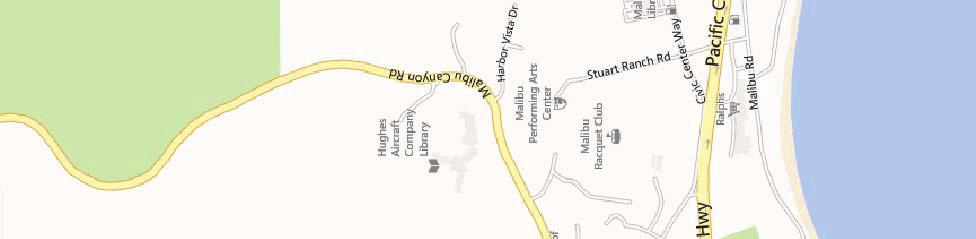


8 : Study Intersections ot to Scale Figure Vicinity Map
9 ot to Scale Figure Existing Lane Configurations
10 Santa Monica Community College District July 2015 Table Existing Traffic Volumes AM Peak Hour PM Peak Hour Sat Mid-day Peak Hour o. Intersection Date Dir. Began Volume Began Volume Began Volume 1 Kanan Dume 07/12/2012 B 8:00 0 4: :00 0 Road/ Pacific 07/14/2012 SB Coast Highway EB 811 1,316 1,330 (SR-1) WB 707 1,253 1,393 2 Malibu Canyon 07/12/2012 B 7: : : Road/ Civic Center 07/14/2012 SB 1, ,027 Way EB Malibu Canyon Road/ Pacific Coast Highway (SR-1) 4 Winter Canyon Road/ Civic Center Way 5 Stuart Ranch Road-Webb Way/ Civic Center Way 6 Webb Way/ Pacific Coast Highway (SR-1) 7 Cross Creek Road/ Civic Center Way 8 Cross Creek Road/ Pacific Coast Highway (SR-1) 9 Malibu Pier Signal/ Pacific Coast Highway (SR-1) 10 Carbon Canyon Road/ Pacific Coast Highway (SR-1) 11 Las Flores Canyon Road/Pacific Coast Highway (SR-1) WB /12/2012 B 8: : : /14/2012 SB 1, EB 1,027 1,467 1,489 WB 778 1,504 1,495 07/12/2012 B 8:00 0 5: : /14/2012 SB EB WB /12/2012 B 8: : : /14/2012 SB EB WB /12/2012 B 8: : : /14/2012 SB EB 1,748 1,382 1,490 WB 1,039 1,819 1,667 07/12/2012 B 8: : : /14/2012 SB EB WB /12/2012 B 8:00 7 4: : /14/2012 SB EB 1,726 1,712 1,616 WB 1,135 1,912 1,858 07/12/2012 B 7:30 0 4: : /14/2012 SB EB 1,674 1,800 1,673 WB 1,203 1,938 1,880 07/12/2012 B 8:00 0 4: : /14/2012 SB EB 1,533 1,687 1,494 WB 1,213 1,814 1,811 07/12/2012 B 7:45 1 4: : /14/2012 SB EB 1,558 1,757 1,496 WB 1,227 1,844 1,815 [1] Counts conducted by City of Malibu. Santa Monica College Malibu Campus Draft EIR Transportation and Circulation - Traffic State Clearinghouse o Page
11 ot to Scale Figure Existing Traffic Volumes: Weekday AM Peak Hour
12 ot to Scale Figure Existing Traffic Volumes: Weekday PM Peak Hour
13 ot to Scale Figure Existing Traffic Volumes: Saturday Mid-Day Peak Hour
14 Santa Monica Community College District July 2015 accessible and pleasant mode of transport. 3 A review of the Project Site location and pedestrian walkway network indicates that these five primary characteristics are accommodated as part of the Proposed Project. The Project Site is accessible from nearby public bus transit stops (serving Metro Line 534), as well as other amenities along Civic Center Way including commercial uses that may be patronized by users of the Proposed Project. b. Traffic Forecasting and Impact Methodology In order to estimate the traffic impact characteristics of the SMC Malibu Campus Project, a multi-step process has been utilized. The first step is trip generation, which estimates the total arriving and departing traffic volumes on a peak hour and daily basis. The traffic generation potential is forecast by applying the appropriate vehicle trip generation equations or rates to the Project development tabulation. The second step of the forecasting process is trip distribution, which identifies the origins and destinations of inbound and outbound Project traffic volumes. These origins and destinations are typically based on demographics and existing/anticipated travel patterns in the study area. The third step is traffic assignment, which involves the allocation of Project traffic to study area streets and intersections. Traffic assignment is typically based on minimization of travel time, which may or may not involve the shortest route, depending on prevailing operating conditions and travel speeds. Traffic distribution patterns are indicated by general percentage orientation, while traffic assignment allocates specific volume forecasts to individual roadway links and intersection turning movements throughout the study area. With the forecasting process complete and Project traffic assignments developed, the impact of the Proposed Project is isolated by comparing operational (i.e., Levels of Service) conditions at the selected key intersections using existing and expected future traffic volumes without and with forecast Project traffic. The need for site-specific and/or cumulative local area traffic improvements can then be evaluated and the significance of the Project s impacts identified. The nine signalized study intersections were evaluated using the Intersection Capacity Utilization (ICU) method of analysis for signalized intersections based on the City s traffic study guidelines. Specifically, the ICU method was used to determine Volume-to-Capacity ratios and corresponding Levels of Service. The ICU calculations use a lane capacity of 1,600 vehicles per hour (vph) for left-turn, through, and rightturn lanes, and dual left-turn capacity of 2,880 vph. Additionally, a clearance adjustment factor of 0.05 was added to each Level of Service calculation. In addition, the two unsignalized study intersections (Stuart Ranch Road-Webb Way/Civic Center Way and Cross Creek Road/Civic Center Way) were also analyzed using the methodology included in the Highway Capacity Manual (HCM). This methodology estimates the average control delay for each of the 3 Government of ew Zealand, Pedestrian etwork Planning and Facilities Design Guide, Chapter 4, website. Santa Monica College Malibu Campus Draft EIR Transportation and Circulation - Traffic State Clearinghouse o Page
15 Santa Monica Community College District July 2015 subject movements and determines the level of service for each constrained movement. Average control delay for any particular movement is a function of the capacity of the approach and the degree of saturation. The overall average control delay is measured in seconds per vehicle. For an all-way stop controlled intersection, the overall intersection delay is subsequently assigned a Level of Service (LOS) value to describe intersection operations. c. Thresholds of Significance The relative impact of the added Project traffic volumes to be generated by the proposed SMC Malibu Campus Project during the weekday AM and PM peak hours and Saturday midday peak hour was evaluated based on analysis of existing-plus-project and future operating conditions at the study intersections, without and with the Proposed Project. The previously discussed capacity analysis procedures were utilized to evaluate the future v/c relationships, potential delay increases, and service level characteristics at each study intersection. The significance of the potential impacts of Project generated traffic at each study intersection was identified using criteria provided by the City of Malibu for those study intersections. According to the City s criteria for calculating the level of impact due to traffic generated by the Proposed Project, a significant transportation impact is determined based on the criteria presented in Table and Table for signalized and unsignalized intersections, respectively. Table City of Malibu Signalized Intersection Impact Threshold Criteria Pre-Project v/c Level of Service Project Related Increase in v/c C Equal to or greater than D Equal to or greater than or more E or F Equal to or greater than Source: Linscott, Law, & Greenspan Engineers, Traffic Impact Study, SMC Malibu Satellite Campus Project, October 17, Table City of Malibu Unsignalized Intersection Impact Threshold Criteria Project Related Increase in Delay Final LOS 5 or more seconds Degrades to LOS D or worse Source: Linscott, Law, & Greenspan Engineers, Traffic Impact Study, SMC Malibu Satellite Campus Project, October 17, The City criteria require mitigation of Project traffic impacts whenever traffic generated by the proposed development causes an increase of the analyzed intersection v/c ratio by an amount equal to or greater than the values shown above for signalized intersections or for certain Project related increase in delay or degradation in level of service to values shown above for unsignalized intersections. Santa Monica College Malibu Campus Draft EIR Transportation and Circulation - Traffic State Clearinghouse o Page
16 Santa Monica Community College District July 2015 (1) Traffic Impact Analysis Scenarios The Level of Service calculations have been prepared for the following scenarios for the study intersections: (a) Existing (Based Study Year 2014) conditions. (b) Existing With Project Conditions. (c) Opening Year Cumulative Year (2017) Pre-Project Conditions including a 1.5 percent (1.5%) annual ambient traffic growth and with completion and occupancy of the related projects. (d) Opening Year With Project Conditions including a 1.5 percent (1.5%) annual ambient traffic growth and with completion and occupancy of the related projects. (e) Future Cumulative (Build out Year 2030) Pre-Project Conditions including a 0.48 percent (0.48%) annual ambient traffic growth and with completion and occupancy of the related projects. (f) Future Cumulative With Project Conditions including a 0.48 percent (0.48%) annual ambient traffic growth and with completion and occupancy of the related projects. d. Project Traffic Generation (1) Weekday Project Trip Generation Summary Traffic volumes expected to be generated by the proposed SMC Malibu Campus Project during the weekday AM and PM peak hours, as well as on a daily basis, were estimated using rates published in the ITE Trip Generation Manual. ITE Land Use Code 540 (Junior/Community College) and ITE Land Use Code 733 (Government Office Complex) trip generation average rates were used to forecast traffic volumes expected to be generated by the educational facility and Sheriff s Substation, respectively. The ITE trip rates based on building floor area were utilized. The traffic generation forecast for the Proposed Project is summarized in Table As summarized in Table , the Project is expected to generate 71 vehicle trips (55 inbound trips and 16 outbound trips) during the weekday AM peak hour. During the weekday PM peak hour, the Project is expected to generate 66 vehicle trips (34 inbound trips and 32 outbound trips). Over a 24-hour period, the Project is forecast to generate 698 daily trip ends during a typical weekday (approximately 349 inbound trips and 349 outbound trips). Santa Monica College Malibu Campus Draft EIR Transportation and Circulation - Traffic State Clearinghouse o Page
17 Santa Monica Community College District July 2015 Table Project Trip Generation Size Daily Trip Ends a AM Peak Hour Volumes PM Peak Hour Volumes SAT Daily Trip Ends SAT Peak Hour Volumes Land use (GSF) Volume In Out Total In Out Total Volumes In Out Total Community College b 19, Sheriff Station c 5, PROJECT TOTAL: otes: a Trips are one-way traffic movements, entering or leaving b ITE Land Use Code 540 (Junior/Community College) trip generation average rates c ITE Land Use Code 733 (Government Office Complex) trip generation average rates See Traffic Study (Appendix J) for detailed list on trip generation average rates. and ITE Trip Generation, 8 th Edition, 2008 (2) Saturday Project Trip Generation Summary The Saturday trip generation forecast for the Proposed Project is also summarized in Table As summarized in Table , the Proposed Project is expected to generate a total of 44 vehicle trips (21 inbound trips and 23 outbound trips) during the Saturday mid-day peak hour. Over a 24-hour weekend period, the Proposed Project is forecast to generate a total of 378 vehicle trips (189 inbound trips and 189 outbound trips). (3) Project Traffic Distribution The general, directional traffic distribution patterns for the Proposed Project was based on the Proposed Project land use, the development site access scheme, survey of travel routes by existing SMC students currently attending classes at the Webster Elementary School, existing traffic patterns, existing intersection traffic volumes, characteristics of the surrounding roadway system, and nearby population and local schools. The proximity and function of the nearby multi-modal corridors, as well as Secondary and Major Highways, was also considered in the development of the Proposed Project traffic distribution pattern. The weekday AM peak hour Project traffic distribution percentages at the study intersections are illustrated in Figure The weekday PM peak hour and Saturday mid-day peak hour Project traffic distribution percentages at the study intersections are illustrated in Figure (4) Project Traffic Assignment The forecast new weekday AM and PM peak hour traffic volumes at the study intersections associated with the Proposed Project are presented in Figures and , respectively. The forecast new Saturday mid-day peak hour traffic volumes at the study intersections associated with the Proposed Project are displayed in Figure The traffic volume assignments presented in Figures , , and reflect the traffic distribution characteristics shown in Figures and and the Project traffic generation forecast presented in Table Santa Monica College Malibu Campus Draft EIR Transportation and Circulation - Traffic State Clearinghouse o Page
18 ot to Scale Figure Project Trip Distribution: Weekday AM Peak Hour
19 ot to Scale Figure Project Trip Distribution: Weekday PM and Saturday Mid-Day Peak Hour
20 ot to Scale Figure Total Project Traffic Volumes: Weekday AM Peak Hour
21 ot to Scale Figure Total Project Traffic Volumes: Weekday PM Peak Hour
22 ot to Scale Figure Total Project Traffic Volumes: Saturday Mid-Day Peak Hour
23 Santa Monica Community College District July 2015 It is likely that some local students attending classes at the proposed SMC Malibu Campus may otherwise attend classes at SMC s Santa Monica campus, or some other college campus in the Los Angeles area. Thus, some or all of these trips may already occur on the local street system related to students commuting to campuses outside the local Malibu community. However, to provide a conservative worst case analysis, no adjustments or credits were made in the traffic analysis for these existing trips on the local street system that may instead travel to the future SMC Malibu Campus (i.e., all Project-related trips were assumed to be new trips on the local street system). Similarly, no trip credits were taken in the traffic analysis for existing SMC classes conducted at nearby Webster Elementary School (which would presumably end with the completed construction of the Project). e. Traffic Analysis The traffic impact analysis prepared for the eleven study intersections using the ICU/HCM methodology and application of the City of Malibu significant traffic impact criteria is summarized in Table for Existing traffic conditions (year 2012). (1) Existing Conditions As indicated in column [1] of Table , all of the eleven study intersections are presently operating at LOS D or better during the weekday AM peak hour, weekday PM peak hour, and Saturday mid-day peak hour under existing conditions. As previously mentioned, the existing traffic volumes at the study intersections during the weekday AM peak hour, weekday PM peak hour and Saturday mid-day peak hour are provided above in Figures , , and , respectively. (2) Existing With Project Conditions As shown in column [2] of Table , application of the City s/county s threshold criteria to the Existing With Project scenario indicates that the Proposed Project is not expected to create significant impacts at any of the eleven study intersections. Incremental, but not significant, impacts are noted at the study intersections. Because there are no significant impacts, no traffic mitigation measures are required or recommended for the study intersections under the Existing With Project conditions. The existing with Project traffic volumes at the study intersections during the weekday AM peak hour, weekday PM peak hour, and Saturday mid-day peak hour are shown in Figures , , and , respectively. f. Congestion Management Program Traffic Impact Assessment The Congestion Management Program (CMP) is a state-mandated program that was enacted by the California State Legislature with the passage of Proposition 111 in The program is intended to address the impact of local growth on the regional transportation system. As required by the 2010 Congestion Management Program for Los Angeles County, a Traffic Impact Assessment (TIA) has been prepared to determine the potential impacts on designated monitoring locations on the CMP highway system. The analysis has been prepared in accordance with procedures Santa Monica College Malibu Campus Draft EIR Transportation and Circulation - Traffic State Clearinghouse o Page
24 Santa Monica Community College District July 2015 Table , Summary of Volume to Capacity Ratios/Delays and Levels of Service for Year 2014 (Existing) Weekday AM, PM and Weekend Mid-Day Peak Hours o. Intersection 1 Kanan Dume Road/ Pacific Coast Highway (SR-1) [a] 2 Malibu Canyon Road/ Civic Center Way [a] 3 Malibu Canyon Road/ Pacific Coast Highway (SR-1) [a] 4 Winter Canyon Road/ Civic Center Way [a] 5 Stuart Ranch Road Webb Way/ Civic Center Way [a] 6 Webb Way/ Pacific Coast Highway (SR- 1) [a] 7 Cross Creek Road/ Civic Center Way [a] 8 Cross Creek Road/ Pacific Coast Highway (SR-1) [a] 9 Malibu Pier Signal/ Pacific Coast Highway (SR-1) [a] 10 Carbon Canyon Road/ Pacific Coast Highway (SR-1) [b] 11 Las Flores Canyon Road / Pacific Coast Highway (SR-1) [a] [1] [2] Year 2014 Existing Year 2014 Existing Change w/ Project V/C or Peak Hour V/C or Delay LOS V/C or Delay LOS Delay [(2)-(1)] Signif. Impact AM A A O PM B B O SAT D D O AM A A O PM A A O SAT A A O AM B B O PM B B O SAT C C O AM A A O PM A A O SAT A A O AM 10.3 B 10.3 B 0.0 O PM 24.4 C 25.0 C 0.5 O SAT 9.9 A 10.0 A 0.1 O AM A A O PM B B O SAT B B O AM 7.8 A 7.9 A 0.1 O PM 9.1 A 9.3 A 0.2 O SAT 9.2 A 9.3 A 0.1 O AM B B O PM C D O SAT D D O AM A A O PM B B O SAT B B O AM A A O PM B B O SAT B B O AM A A O PM C C O SAT B B O [a] City of Malibu signalized intersection impact threshold criteria is a follows: Pre-Project v/c LOS Project Related Increase in v/c C 0.04 or more D 0.02 or more 0.91 or more E/F 0.01 or more [b] City of Malibu unsignalized intersection impact threshold criteria is a follows: Project Related Increase in delay 5 or more seconds Final LOS Degrades to level D or worse. Santa Monica College Malibu Campus Draft EIR Transportation and Circulation - Traffic State Clearinghouse o Page
25 ot to Scale Figure Existing with Project Traffic Volumes: Weekday AM Peak Hour
26 ot to Scale Figure Existing with Project Traffic Volumes: Weekday PM Peak Hour
27 ot to Scale Figure Existing with Project Traffic Volumes: Saturday Mid-Day Peak Hour
28 Santa Monica Community College District July 2015 outlined in the 2010 Congestion Management Program, County of Los Angeles Metropolitan Transportation Authority, According to Section D.9.1 of the 2010 CMP manual, the criteria for determining a significant transportation impact is listed below: A significant transportation impact occurs when the Proposed Project increases traffic demand on a CMP facility by 2% of capacity (V/C > 0.02), causing or worsening LOS F (V/C > 1.00). The CMP impact criteria apply for analysis of both intersection and freeway monitoring locations. (1) Intersections The following CMP intersection monitoring locations in the Project vicinity have been identified: CMP Station Intersection o. 107 Pacific Coast Highway/Kanan Dume Road (Study Int. o. 1) o. 108 Pacific Coast Highway/Las Flores Canyon Road (Study Int. o. 11) o. 109 Pacific Coast Highway/Malibu Canyon Road (Study Int. o. 3) The CMP TIA guidelines require that intersection monitoring locations must be examined if the Proposed Project will add 50 or more trips during either the AM or PM weekday peak hours. The Proposed Project will not add 50 or more trips during either the AM or PM weekday peak hours (i.e., of adjacent street traffic) at any of the three CMP monitoring intersections in the Project vicinity, which is stated in the CMP manual as the threshold criteria for a traffic impact assessment. The weekday AM, PM, and Saturday mid-day forecast Project trips anticipated at each of the three locations are as follows: o. 107: Pacific Coast Highway/Kanan Dume Road (Study Int. o. 1) AM Peak Hour: 18 trips; PM peak hour: 17 trips; Saturday Mid-day peak hour: 11 trips o. 108: Pacific Coast Highway/Las Flores Canyon Road (Study Int. o. 11) AM Peak Hour: 26 trips; PM peak hour: 25 trips; Saturday Mid-day peak hour: 15 trips o. 109: Pacific Coast Highway/Malibu Canyon Road (Study Int. o. 3) AM Peak Hour: 30 trips; PM peak hour: 20 trips; Saturday Mid-day peak hour: 13 trips Also as summarized in Table (above) and Tables and (below), none of these three intersections are anticipated to be significantly impacted by the Proposed Project. Therefore, no further review of potential impacts to intersection monitoring locations that are part of the CMP highway system is required. Santa Monica College Malibu Campus Draft EIR Transportation and Circulation - Traffic State Clearinghouse o Page
29 Santa Monica Community College District July 2015 (2) Freeways o CMP intersection monitoring freeway locations are identified in the Project vicinity. The CMP TIA guidelines require that freeway monitoring locations must be examined if the Proposed Project will add 150 or more trips (in either direction) during either the AM or PM weekday peak periods. The Proposed Project will not add 150 or more trips (in either direction), during either the AM or PM weekday peak hours to any CMP freeway monitoring location, which is the threshold for preparing a traffic impact assessment, as stated in the CMP manual. Therefore, no further review of potential impacts to freeway monitoring locations that are part of the CMP highway system is required. (3) Transit Impact Review As required by the 2010 Congestion Management Program, a review has been made of the potential impacts of the Project on transit service. As previously discussed, existing transit service is provided in the vicinity of the proposed SMC Malibu Campus Project. The Project trip generation, as shown in Table , was adjusted by values set forth in the CMP (i.e., person trips equal 1.4 times vehicle trips, and transit trips equal 3.5 percent of the total person trips) to estimate transit trip generation. Pursuant to the CMP guidelines, the Proposed Project is forecast to generate demand for 4 transit trips during the weekday AM peak hour, 4 transit trips during the weekday PM peak hour, and 3 transit trips during the Saturday mid-day peak hour. Over a 24-hour weekday and Saturday period, the Proposed Project is forecast to generate demand for 35 and 19 daily transit trips, respectively. The transit trip calculations are as follows: Weekday AM Peak Hour = = 4 Transit Trips Weekday PM Peak Hour = = 4 Transit Trips Weekday Daily Trips = = 35 Transit Trips Saturday Mid-day Peak Hour = = 3 Transit Trips Saturday Daily Trips = = 19 Transit Trips As shown in Table , one bus transit line is provided adjacent to or in close proximity the Project Site. As outlined in Table , under the o. of Buses During Peak Hour column, the transit line provides services for an average of (i.e., average of the directional number of buses during the peak hours) generally seven buses during the weekday AM peak hour and roughly six buses during the weekday PM peak hour. During the weekend day, this transit line provides services for an average of four buses during the Saturday mid-day peak hour. Therefore, based on the above calculated weekday AM and PM peak hour trips, as well as the Saturday mid-day peak hour trips, this would correspond to approximately one additional transit rider per bus. It is anticipated that the existing transit service in the Project area will adequately accommodate the increase of Project-generated transit trips. Thus, given the low number of Project-generated transit trips per bus, no Project impacts on existing or future transit services in the Project area are expected to occur as a result of the Proposed Project. Santa Monica College Malibu Campus Draft EIR Transportation and Circulation - Traffic State Clearinghouse o Page
30 Santa Monica Community College District July 2015 g. Construction Traffic-Related Impacts Project construction would generate traffic from construction worker travel, as well as the arrival and departure of trucks delivering construction materials to the Project Site and removing debris generated by on-site demolition activities. Both the number of construction workers and trucks would vary throughout the construction process in order to maintain a reasonable schedule of completion. In general, it is anticipated that construction workers arrive and depart from the Project Site during offpeak hours and the construction-related traffic would be largely freeway-oriented. Construction workers would arrive and depart via the Pacific Coast Highway (SR-1), located to the south of the Project Site. The Pacific Coast Highway would connect to I-10 Freeway and link to the greater Los Angeles highway network. The construction traffic leaving the Project Site could access the Pacific Coast Highway (SR-1) via Cross Creek Road, to the east of the Project Site, or Webb Way, to the west of the Project Site. Both Cross Creek Road and Webb Way are considered collector roadways, according to the City of Malibu s Circulation Element. The construction work force would likely be from all parts of the Los Angeles region and are assumed to arrive from the Pacific Coast Highway via I-10 and from Malibu Canyon Drive from the I-101 (Ventura) Freeway. In general, the majority of the construction workers are expected to arrive and depart the Project Site during off-peak hours (i.e., arrive prior to 7:00am and depart between 3:00pm and 4:00pm) thereby avoiding generating trips during the 7:00 to 9:00am and 4:00 to 6:00pm peak traffic periods. Consequently, the impact generated by construction traffic on peak-hour traffic in the vicinity of the Project Site would be negligible. Given the off-peak nature of construction worker traffic, a less-than-significant impact is anticipated with regard to the local roadway network. Temporary partial lane closure on Civic Center Way may occur during Project construction to allow for deliveries and haul trucks to safely access and depart the Project Site. It is not anticipated that detours around Civic Center Way or complete road closures would result from construction activities. Flagmen would be used to control traffic movement during the ingress and egress of trucks and heavy equipment from the construction site. Depending upon the specific nature of the construction activity (e.g. demolition, site preparation, and building construction phase), it is assumed the majority of truck traffic would be distributed evenly across the workday. The Proposed Project suggests two possible haul routes, which would be subject to the approval of the City of Malibu and/or County of Los Angeles Department of Public Works, Traffic and Lighting Division. Under the first route, haul trucks and delivery trucks would generally travel along Civic Center Way between Cross Creek Road and Stuart Ranch Road/Webb Way, the portion of Cross Creek Road between Civic Center Way and Pacific Coast Highway, Webb Way, the Pacific Coast Highway, and Interstate 10 Freeway, to access and depart the Project Site. Alternatively, the local haul route may include entering/exiting the Project Site from Civic from Center Way, and using Malibu Canyon Road to reach the Calabasas, Sunshine Canyon or Chiquita Canyon landfills located outside of the City of Malibu. The route utilizing Malibu Canyon Road would require prior written approval from the County of Los Angeles. With regard to the other construction trafficrelated issues, construction equipment would be stored on the construction site, and construction workers would be directed to park on-site. Thus no spill over parking impacts will occur. Impacts from construction activities are therefore concluded to be less than significant. Santa Monica College Malibu Campus Draft EIR Transportation and Circulation - Traffic State Clearinghouse o Page
31 Santa Monica Community College District July CUMULATIVE IMPACTS a. Cumulative Development Projects The forecast of future pre-project conditions was prepared in accordance with procedures outlined in Section of the CEQA Guidelines. Specifically, the CEQA Guidelines provides two options for developing the future traffic volume forecast: (A) A list of past, present, and probable future projects producing related or cumulative impacts, including, if necessary, those projects outside the control of the [lead] agency, or (B) A summary of projections contained in an adopted local, regional or statewide plan, or related planning document, that describes or evaluates conditions contributing to the cumulative effect. Such plans may include: of greenhouse gas emissions. A summary of projections may also be contained in an adopted of certified prior environmental document for such a plan. Such projections may be supplemented with additional information such as a regional modeling program. Any such planning document shall be referenced and made available to the public at a location specified by the lead agency. Accordingly, the traffic analysis provides a highly conservative estimate of future pre-project traffic volumes as it incorporates both the A and B options outlined in the CEQA Guidelines for purposes of developing the forecast. (1) Related Projects A forecast of on-street traffic conditions prior to occupancy of the Proposed Project was prepared by incorporating the potential trips associated with other known development projects (related projects) in the area. With this information, the potential impact of the Proposed Project can be evaluated within the context of the cumulative impact of all ongoing development. The related projects research was based on information provided by the City of Malibu Planning Department, as well as recently accepted traffic impact analysis reports prepared for projects in the vicinity of the Proposed Project Site. The list of related projects in the Project Site area is presented in the Related Projects Table in the Project Description, Section II. The location of the related projects is shown in the Project Description, Section II. Traffic volumes expected to be generated by the related projects were calculated using rates provided in the Institute of Transportation Engineers (ITE) Trip Generation manual. 4 The related projects respective traffic generation for the weekday AM and PM peak hours, as well as on a daily basis for a typical weekday, is summarized in Table 7-1, Related Projects List and Trip Generation Table in the Project Traffic Study (see Appendix J of this EIR). The anticipated distribution of the related projects traffic volumes to the study intersections during the weekday AM and PM peak hours are displayed in Figures and , respectively. The related projects respective Saturday traffic generation for the midday peak hour, as well as on a daily basis, is also summarized in Table 7-1 in Appendix J. The forecast assignment of the related projects traffic volumes to the study intersections during the Saturday mid-day 4 Institute of Transportation Engineers Trip Generation manual, 9th Edition, Washington, D.C., Santa Monica College Malibu Campus Draft EIR Transportation and Circulation - Traffic State Clearinghouse o Page
TRAFFIC & TRANSPORTATION COMMISSION AGENDA REPORT
 TRAFFIC & TRANSPORTATION COMMISSION AGENDA REPORT AGENDA ITEM #4 T/T MTG: 092616 DATE: SEPTEMBER 26, 2016 TO: TRAFFIC & TRANSPORTATION COMMISSION FROM: BENJAMIN CHAN, P.E, T.E., DEPUTY PUBLIC WORKS DIRECTOR
APPENDIX B. Public Works and Development Engineering Services Division Guidelines for Traffic Impact Studies
 APPENDIX B Public Works and Development Engineering Services Division Guidelines for Traffic Impact Studies Revised December 7, 2010 via Resolution # 100991 Reformatted March 18, 2011 TABLE OF CONTENTS
Woodburn Interchange Project Transportation Technical Report
 Final Report Woodburn Interchange Project Transportation Technical Report Prepared for Oregon Department of Transportation April 212 Prepared by DKS Associates Contents Methodologies... 4 Volume Development...
TRANSPORTATION IMPACT ANALYSIS GUIDELINES
 TRANSPORTATION IMPACT ANALYSIS GUIDELINES SANTA CLARA COUNTY TRANSPORTATION AUTHORITY CONGESTION MANAGEMENT PROGRAM ADOPTED MARCH 2009 TABLE OF CONTENTS PART I - STATUTE AND AUTHORITY...1 CHAPTER 1. CMP
Transportation and Works Department The Regional Municipality of York Yonge Street Newmarket, Ontario L3Y 6Z1
 TRANSPORTATION IMPACT STUDY (TIS) GUIDELINES FOR DEVELOPMENT APPLICATIONS Transportation and Works Department The Regional Municipality of York 17250 Yonge Street Newmarket, Ontario L3Y 6Z1 August, 2007
CITY OF CLOVIS Traffic Impact Study Guidelines
 CITY OF CLOVIS Traffic Impact Study Guidelines CLOVIS, A WAY OF LIFE Approved August 25, 2014 City Council Resolution 2014-79 Prepared by City of Clovis Engineering Division Steve White, City Engineer
APPENDIX H: TRAVEL DEMAND MODEL VALIDATION AND ANALYSIS
 APPENDIX H: TRAVEL DEMAND MODEL VALIDATION AND ANALYSIS Travel demand models (TDM) simulate current travel conditions and forecast future travel patterns and conditions based on planned system improvements
MULTIMODAL TRANSPORTATION IMPACT STUDY GUIDELINES
 MULTIMODAL TRANSPORTATION IMPACT STUDY GUIDELINES 1 st Edition City of San Luis Obispo 2035 Circulation Element 1 Table of Contents Introduction... 2 Process... 2 When Impact Studies Are Required... 3
TRANSPORTATION IMPACT ANALYSIS GUIDELINES FOR ENVIRONMENTAL REVIEW
 TRANSPORTATION IMPACT ANALYSIS GUIDELINES FOR ENVIRONMENTAL REVIEW October 2002 The Planning Department City and County of San Francisco TABLE OF CONTENTS I. Introduction 1 II. Overview of Process and
THE PROJECT. Executive Summary. City of Industry. City of Diamond Bar. 57/60 Confluence.
 THE PROJECT A freeway segment ranked 6th worst in the Nation, with levels of congestion, pollution and accidents that are simply unacceptable and which have Statewide and National implications. Executive
The Folded Interchange: An Unconventional Design for the Reconstruction of Cloverleaf Interchanges
 The Folded Interchange: An Unconventional Design for the Reconstruction of Cloverleaf Interchanges I. ABSTRACT Keith A. Riniker, PE, PTOE This paper presents the Folded Interchange design and compares
DEVELOPMENT, ANALYSIS, AND DESIGN OF A NEW PARKWAY AT GRADE INTERSECTION (PAGI)
") 2013 ITE Western District Annual Meeting COCEPT DEVELOPMET, AALYSIS, AD DESIG OF A EW PARKWAY AT GRADE ITERSECTIO (PAGI) Lead Author: James M. Witkowski, PhD Supporting Author: Darrell Truitt, PE The Pima
2013 ITE Western District Annual Meeting COCEPT DEVELOPMET, AALYSIS, AD DESIG OF A EW PARKWAY AT GRADE ITERSECTIO (PAGI) Lead Author: James M. Witkowski, PhD Supporting Author: Darrell Truitt, PE The Pima
ADDENDUM TO THE EIR. Specifically, Section of the CEQA Guidelines states:
 ADDENDUM TO THE EIR Section 15160 of the CEQA Guidelines explains that there are several mechanisms, and variations in environmental documents, that can be tailored to different situations and intended
Appendix H. Millennium Hollywood Project Trip Cap and Mitigation Triggers
 Appendix H Millennium Hollywood Project Trip Cap and Mitigation Triggers MILLENNIUM HOLLYWOOD PROJECT TRIP CAP AND MITIGATION TRIGGERS Crain and Associates Introduction The Millennium Hollywood Project
6.2.2 Environmental Consequences and Mitigation Measures
 6.2 6.2.1 Introduction The existing conditions, regulatory setting, and methods of analysis for transportation under CEQA are described in Chapter 3, NEPA and CEQA Analysis. Impacts that would result from
1.1 Purpose of the Project
 Chapter 1 Purpose and Need for East Link Project 1.1 Purpose of the Project The purpose of the East Link Project is to expand the Sound Transit Link light rail system from Seattle to Mercer Island, Bellevue
FINAL ENVIRONMENTAL IMPACT REPORT Volume 1. NBC Universal Evolution Plan ENV EIR STATE CLEARINGHOUSE NO Council District 4
 Division of Land / Environmental Review City Hall 200 N. Spring Street, Room 750 Los Angeles, CA 90012 FINAL ENVIRONMENTAL IMPACT REPORT Volume 1 ENV-2007-0254-EIR STATE CLEARINGHOUSE NO. 2007071036 Council
Re: Mobility Plan 2035 FEIR Greenhouse Gas Emissions Analysis
 Sirius Environmental Claire Bowin, Senior City Planner City of Los Angeles, Department of City Planning 200 North Spring Street, Room 272 Los Angeles, California 90012 Dear Claire: Re: Mobility Plan 2035
Notice of Preparation For Link Union Station (Link US) Project. Joint Environmental Impact Statement and Environmental Impact Report
 Project. Joint Environmental Impact Statement and Environmental Impact Report") Notice of Preparation For Link Union Station (Link US) Project Joint Environmental Impact Statement and Environmental Impact Report Date: May 27, 2016 To: Subject: Project Title: From: All Interested Agencies,
Notice of Preparation For Link Union Station (Link US) Project Joint Environmental Impact Statement and Environmental Impact Report Date: May 27, 2016 To: Subject: Project Title: From: All Interested Agencies,
City College of San Francisco. Master Plan Final Environmental Impact Report. John Adams Campus EIR Addendum. August 18, 2006
 City College of San Francisco Master Plan Final Environmental Impact Report John Adams Campus EIR Addendum August 18, City College of San Francisco John Adams Campus EIR Addendum TABLE OF CONTENTS Page
TRANSPORTATION IMPACT STUDIES
 January 28, 2009 POLICIES AND PROCEDURES FOR TRANSPORTATION IMPACT STUDIES Related to Highway Occupancy Permits Pennsylvania Department of Transportation Bureau of Highway Safety and Traffic Engineering
Shannon Noonan, City of Cambridge Don Drackley, IBI Group Scott Johnson, IBI Group PTSL
 100 175 Galaxy Boulevard Toronto ON M9W 0C9 Canada tel 416 679 1930 fax 416 675 4620 ibigroup.com Memorandum To/Attention From cc Shannon Noonan, City of Cambridge Don Drackley, IBI Group Scott Johnson,
Executive Summary Introduction and Background
 ES.1 Introduction and Background The Los Angeles County Metropolitan Transportation Authority (LACMTA) completed the Final Environmental Impact Report/Environmental Assessment (Final EIR/EA) for the Wilshire
Memorandum. 921 SW Washington Street, Suite 468, Portland, OR tel fax
 Date: September 16, 2010 To: I-84/US 395 IAMP Project Team From: Shayna Rehberg, AICP Darci Rudzinski, AICP Re: I-84/US 395 Interchange Area Management Plan Proposed IAMP Policies and Code Amendments L
TABLE OF CONTENTS PAGE NUMBER. Executive Summary Why Variable Pricing? What Was Studied? User Surveys Air Quality Analysis User And Equity Analysis
 TABLE OF CONTENTS PAGE NUMBER Executive Summary Why Variable Pricing? What Was Studied? User Surveys Air Quality Analysis User And Equity Analysis Findings Scenario 1 Base Case Scenario 2 Detoll Scenario
3.14 TRANSPORTATION AND TRAFFIC
 3.14 TRANSPORTATION AND TRAFFIC 3.14.1 INTRODUCTION This section presents an overview of the existing traffic and circulation system in the area surrounding the project site. It also discusses the potential
Memorandum. FROM: Jim Ortbal Rosalynn Hughey Barry Ng TO: HONORABLE MAYOR, CITY COUNCIL. DATE: June 16, 2017
 CITY OF SANjOSE CAPITAL OF SILICON VALLEY TO: HONORABLE MAYOR, CITY COUNCIL SUBJECT: TRANSPORTATION POLICY UPDATE REQUIRED BY STATE LAW - LOS TO VMT Memorandum FROM: Jim Ortbal Rosalynn Hughey Barry Ng
Executive Summary. Overview
 Executive Summary Overview The Genesee-Finger Lakes Diversion Route Initiative identifies the most suitable diversion routes for Principal Arterial roads in the nine-county Genesee-Finger Lakes Region.
Transform 66 Multimodal Project: Prioritization Process and Evaluation Criteria Approved March 3, 2016
 Transform 66 Multimodal Project: Prioritization Process and Evaluation Criteria Approved March 3, 2016 The Memorandum of Agreement (MOA) for the Transform 66: Inside the Beltway Project directs NVTC to
Transit Service Guidelines
 G R E AT E R VA N CO U V E R T R A N S P O RTAT I O N A U T H O R I T Y Transit Service Guidelines PUBLIC SUMMARY REPORT JUNE 2004 Greater Vancouver Transportation Authority TRANSIT SERVICE GUIDELINES
Exposition Light Rail Transit Project
 Exposition Light Rail Transit Project Downtown & Mid-Corridor Project Status Update Meeting Holman United Methodist Church Thursday, July 23, 2009 Phase 1 Project Description 8.6 mile corridor from Downtown
COMPREHENSIVE TRANSPORTATION REVIEW THE WHARF PHASE 2 PUD
 COMPREHENSIVE TRANSPORTATION REVIEW THE WHARF PHASE 2 PUD WASHINGTON, DC September 18, 2017 Prepared by: 1140 Connecticut Avenue NW Suite 600 Washington, DC 20036 Tel: 202.296.8625 Fax: 202.785.1276 3914
Appendix D: Functional Classification Criteria and Characteristics, and MnDOT Access Guidance
 APPENDICES Appendix D: Functional Classification Criteria and Characteristics, and MnDOT Access Guidance D.1 Functional classification identifies the role a highway or street plays in the transportation
LAS VEGAS STREET RAILROAD CROSSING RR/PUC CONNECTION AND PRELIMINARY DESIGN
 LAS VEGAS STREET RAILROAD CROSSING RR/PUC CONNECTION AND PRELIMINARY DESIGN Prepared for: City of Colorado Springs Prepared by: Felsburg Holt & Ullevig 508 South Tejon Street Colorado Springs, CO 80903
NW La Center Road/I-5 Interchange Improvement Project (MP 16.80)
") FINAL DRAFT - NW La Center Road/I-5 Interchange Improvement Project (MP 16.80) La Center, Washington February 2015 FINAL DRAFT - NW La Center Road/I-5 Interchange Improvement Project (MP 16.80) La Center,
FINAL DRAFT - NW La Center Road/I-5 Interchange Improvement Project (MP 16.80) La Center, Washington February 2015 FINAL DRAFT - NW La Center Road/I-5 Interchange Improvement Project (MP 16.80) La Center,
TECHNICAL MEMORANDUM I-710 EIR/EIS INITIAL FEASIBILITY ANALYSIS (IFA) TECHNICAL APPENDIX WBS TASK ID:
 TECHNICAL APPENDIX WBS TASK ID:") FINAL REPORT TECHNICAL MEMORANDUM I-710 EIR/EIS INITIAL FEASIBILITY ANALYSIS (IFA) TECHNICAL APPENDIX WBS TASK ID: 165.10.09 Prepared for Los Angeles County Metropolitan Transportation Authority December
FINAL REPORT TECHNICAL MEMORANDUM I-710 EIR/EIS INITIAL FEASIBILITY ANALYSIS (IFA) TECHNICAL APPENDIX WBS TASK ID: 165.10.09 Prepared for Los Angeles County Metropolitan Transportation Authority December
Volume to Capacity Estimation of Signalized Road Networks for Metropolitan Transportation Planning. Hiron Fernando, BSCE. A Thesis CIVIL ENGINEERING
 Volume to Capacity Estimation of Signalized Road Networks for Metropolitan Transportation Planning by Hiron Fernando, BSCE A Thesis In CIVIL ENGINEERING Submitted to the Graduate Faculty of Texas Tech
Overall project. The $288 million Phase 2 DesignBuild project starts construction. this spring, with completion by December 31, 2016
 Overall project Johnson County Gateway Interchange Project Improvements 87th Street The $288 million Phase 2 DesignBuild project starts construction this spring, with completion by December 31, 2016 Phase
Jim Alexander Director of Design and Engineering, Southwest Light Rail Transit Project
 Memorandum Date: January 15, 2014 To: CC: From: Subject: Jim Alexander Director of Design and Engineering, Southwest Light Rail Transit Project Paul Danielson, P.E. Project Manager, Southwest Light Rail
APPENDIX C COMMENTS AND RESPONSE TO COMMENTS RECEIVED ON DRAFT NEGATIVE DECLARATION
 APPENDIX C COMMENTS AND RESPONSE TO COMMENTS RECEIVED ON DRAFT NEGATIVE DECLARATION APPENDIX C RESPONSE TO COMMENTS APPENDIX C FINAL NEGATIVE DECLARATION RIM OF THE WORLD SCHOOL DISTRICT SCHOOL CONSOLIDATION
November 8, RE: Harrah s Station Square Casino Transportation Analysis Detailed Traffic Impact Study Review. Dear Mr. Rowe:
 November 8, 2006 Mr. Glenn Rowe, P.E. Pennsylvania Department of Transportation Bureau of Highway Safety and Traffic Engineering Commonwealth Keystone Building 400 North Street, 6 th Floor Harrisburg,
The Secrets to HCM Consistency Using Simulation Models
 The Secrets to HCM Consistency Using Simulation Models Ronald T. Milam, AICP David Stanek, PE Chris Breiland Fehr & Peers 2990 Lava Ridge Court, Suite 200 Roseville, CA 95661 r.milam@fehrandpeers.com (916)
Letter No Impact Sciences, Inc Temporary use of the Rose Bowl by the NFL November 2012
 Letter No. 48 1 3.0-303 1 2 3 3.0-304 3 4 5 3.0-305 6 7 8 9 10 11 3.0-306 12 13 3.0-307 13 14 3.0-308 14 15 3.0-309 15 3.0-310 16 3.0-311 16 17 3.0-312 17 18 19 3.0-313 19 20 21 22 3.0-314 22 23 24 3.0-315
Notice of Preparation of an Environmental Impact Report. Case No.: E Reception: 41.
 COUN ((7\ SAN FRANCISCO PLANNING DEPARTMENT... Is. 1650 Mission St. Suite 400 San Francisco, Date: CA 94103-2479 Case No.: 2012.0176E Reception: 41 Project Title: Transportation Sustainability Program
FINDINGS CALIFORNIA DEPARTMENT OF TRANSPORTATION FINDINGS FOR THE INTERSTATE 10 CORRIDOR PROJECT SAN BERNARDINO AND LOS ANGELES COUNTIES, CALIFORNIA
 FINDINGS CALIFORNIA DEPARTMENT OF TRANSPORTATION FINDINGS FOR THE INTERSTATE 10 CORRIDOR PROJECT SAN BERNARDINO AND LOS ANGELES COUNTIES, CALIFORNIA DISTRICT 7 LA 10 (PM 44.0/48.3) DISTRICT 8 SBD 10 (PM
A+ ACADEMY HIGH SCHOOL
 TRAFFIC MANAGEMENT PLAN FOR A+ ACADEMY HIGH SCHOOL IN DALLAS, TEXAS Prepared for: A+ Charter Schools, Inc. 8225 Bruton Road Dallas, Texas 75217 Prepared by: Texas Registered Engineering Firm F-3199 400
This comparison is designed to satisfy the requirements of State CEQA Guidelines, Section (d), Evaluation of Alternatives, which state that:
, Evaluation of Alternatives, which state that:") 6.0 Comparison of Proposed Project and Alternatives This chapter summarizes the environmental advantages and disadvantages associated with the Proposed Project and the alternatives. Based upon this discussion,
6.0 Comparison of Proposed Project and Alternatives This chapter summarizes the environmental advantages and disadvantages associated with the Proposed Project and the alternatives. Based upon this discussion,
The New Highway Capacity Manual 6 th Edition It s Not Your Father s HCM
 The New Highway Capacity Manual 6 th Edition It s Not Your Father s HCM Tom Creasey, PE, PhD Principal, Stantec Consulting Services Inc. Chair, TRB Highway Capacity and Quality of Service Committee Presented
DISTRICT OF NORTH VANCOUVER GUIDELINES FOR THE DEVELOPMENT OF CONSTRUCTION TRAFFIC MANAGEMENT PLANS
 DISTRICT OF NORTH VANCOUVER GUIDELINES FOR THE DEVELOPMENT OF CONSTRUCTION TRAFFIC MANAGEMENT PLANS Construction Impact Mitigation Strategy Guidelines for Major Developments The District of North Vancouver
SAN BERNARDINO COUNTY CONGESTION MANAGEMENT PROGRAM
 SAN BERNARDINO COUNTY CONGESTION MANAGEMENT PROGRAM 2016 Update Prepared by SAN BERNARDINO ASSOCIATED GOVERNMENTS June 2016 TABLE OF CONTENTS Contents Table of Contents... i Preface... iii 1. Introduction...
NEW ORLEANS REGION TRANSIT COMPREHENSIVE OPERATIONS ANALYSIS SCOPE OF SERVICES. RPC Project LA90X361
 NEW ORLEANS REGION TRANSIT COMPREHENSIVE OPERATIONS ANALYSIS SCOPE OF SERVICES RPC Project LA90X361 Overview Summary The purpose of the Comprehensive Operations Analysis (COA) is to provide detailed review
Access Management Manual December 2003
 Access Management Manual December 2003 2003 Texas Department of Transportation Published by the Design Division (DES) All rights reserved Access Management Manual December 2003 Manual Notices Manual Notice
FLORIDA DEPARTMENT OF TRANSPORTATION Planning and Environmental Management Office INTERCHANGE MODIFICATION REPORT
 FLORIDA DEPARTMENT OF TRANSPORTATION Planning and Environmental Management Office INTERCHANGE MODIFICATION REPORT District 2 1109 South Marion Avenue Lake City, FL 32025-5874 INTERSTATE 10 (SR 8) / SR
Table of Contents. Executive Summary. 1.0 Background and Scope of Work. 2.0 Project Definition. 3.0 Traffic Summary. 4.0 Structural Systems
 Final cope Report October 20, 2010 Table of Contents E Executive ummary 1.0 Background and cope of Work 2.0 Project Definition 3.0 Traffic ummary 4.0 tructural ystems 5.0 Proposed chedule 6.0 Project Costs
Analytical Tools and Decision Support Systems SANDAG I-15 ICM. ITS PA January 30 th, 2014
 Analytical Tools and Decision Support Systems SANDAG I-15 ICM ITS PA January 30 th, 2014 Project Partners/Stakeholders National ICM Evaluator National AMS Contractor 2 San Diego I-15 Corridor 21 mile corridor
Montgomery County, MD
 Montgomery County, MD Jurisdictional Context The Montgomery County Planning Board is responsible for approving private sector development projects for the unincorporated areas of the County. Cities and
Executive Summary October 2017
 Executive Summary The King of Prussia Rail Draft Environmental Impact Statement/Draft Section 4(f) Evaluation (DEIS) describes and summarizes the transportation and environmental benefits and impacts of
I-70 East ROD 1: Phase 1 (Central 70 Project) Air Quality Conformity Technical Report
 Air Quality Conformity Technical Report") I-70 East ROD 1: Air Quality Conformity Technical Report January 2017 I-70 East ROD 1: Air Quality Conformity Technical Report TABLE OF CONTENTS Chapter Page 1 PURPOSE OF THIS REPORT... 1 2 PROJECT DESCRIPTION...
I-70 East ROD 1: Air Quality Conformity Technical Report January 2017 I-70 East ROD 1: Air Quality Conformity Technical Report TABLE OF CONTENTS Chapter Page 1 PURPOSE OF THIS REPORT... 1 2 PROJECT DESCRIPTION...
HB2 Implementation Policy Guide
 report HB2 Implementation Policy Guide prepared for Commonwealth Transportation Board date August 1, 2015 6.0 Appendix A: Safety Measures Table 6.1 Safety Factor Measures Summary ID Measure Name Weight
PIMA COUNTY REGIONAL ACCESS MANAGEMENT PLAN (RAMP) LOCAL AND NON-LOCAL ACCESS MANAGEMENT PROGRAMS DELIVERABLE 1B
 LOCAL AND NON-LOCAL ACCESS MANAGEMENT PROGRAMS DELIVERABLE 1B") PIMA COUNTY REGIONAL ACCESS MANAGEMENT PLAN (RAMP) LOCAL AND NON-LOCAL ACCESS MANAGEMENT PROGRAMS DELIVERABLE 1B April 2008 Prepared by: Curtis Lueck & Associates 5460 West Four Barrel Court Tucson, AZ
PIMA COUNTY REGIONAL ACCESS MANAGEMENT PLAN (RAMP) LOCAL AND NON-LOCAL ACCESS MANAGEMENT PROGRAMS DELIVERABLE 1B April 2008 Prepared by: Curtis Lueck & Associates 5460 West Four Barrel Court Tucson, AZ
FAIRFAX COUNTY PARK-AND-RIDE DEMAND ESTIMATION STUDY
 FAIRFAX COUNTY PARK-AND-RIDE DEMAND ESTIMATION STUDY Michael Demmon GIS Spatial Analyst Fairfax County, DOT Fairfax, VA Scudder Wagg Planner Michael Baker Jr, Inc. Richmond, VA Additional support from:
California Environmental Quality Act Findings LAX Terminals 2 and 3 Modernization Project 1. Project Description Summary
 California Environmental Quality Act Findings LAX Terminals 2 and 3 Modernization Project 1. Project Description Summary The (LAX) Terminals 2 and 3 (T2/T3) Modernization Project includes the modernization
Draft Environmental Impact Report Serramonte Views Condominiums and Hotel Project
 Draft Environmental Impact Report Serramonte Views Condominiums and Hotel Project File Nos. GPA-9-14-9640, PD-9-14-9637, SUB-9-14-9643, Design Review-9-14-9644, UPR-1-18-013248 SCH# 2016062063 Prepared
SR 99 Incident Response After- Action Plan
 SR 99 Incident Response After- Action Plan Background On June 10, 2014 at 1:52 PM, a pickup truck and a passenger car collided on southbound SR 99 (E Marginal Way S), just south of S Spokane St. The SDOT
II. Corrections and Additions
 II. Corrections and Additions This section of the Final EIR provides changes to the Draft EIR that have been made to clarify, correct, or add to the environmental impact analysis for the Project (Project).
CITY OF JACKSONVILLE 2030 MOBILITY PLAN STUDY UPDATE GOALS, OBJECTIVES, AND PERFORMANCE MEASURES PREPARED FOR: CITY OF JACKSONVILLE
 CITY OF JACKSONVILLE 2030 MOBILITY PLAN STUDY UPDATE GOALS, OBJECTIVES, AND PERFORMANCE MEASURES 3.20.2017 PREPARED FOR: CITY OF JACKSONVILLE 55 Railroad Row White River Junction, VT 05001 802.295.4999
Simbol Calipatria II CUP # SmCP-2 Project Trip Assignment
 Path: L:\SanDiego\HudsonRanch_Geothermal\MAPS\MXDs\Figure_4_14-4_SmCP2_Project_Trip_Assignment.mxd Riverside County Imperial County MEXICO Simbol Calipatria II CUP #12-0005 SmCP-2 Project Trip Assignment
TRANSPORTATION TRANSPORTATION 9-1
 TRANSPORTATION Community Vision 2028 Because we place such high value on our natural surroundings, we responsibly plan for, manage, and mitigate the impacts of growth on those surroundings. Kezziah Watkins
NOTICE OF PREPARATION OF AN ENVIRONMENTAL IMPACT REPORT
 Date: September 19, 2017 NOTICE OF PREPARATION OF AN ENVIRONMENTAL IMPACT REPORT To: Agencies and Interested Parties Lead Agency: Sacramento Municipal Utility District 6201 S Street, MS B203 Sacramento,
City of Palo Alto (ID # 7047) City Council Staff Report
 City Council Staff Report") City of Palo Alto (ID # 7047) City Council Staff Report Report Type: Consent Calendar Meeting Date: 6/13/2016 Summary Title: East Palo Alto Comment Letter Title: Approval and Authorization for the City
City of Palo Alto (ID # 7047) City Council Staff Report Report Type: Consent Calendar Meeting Date: 6/13/2016 Summary Title: East Palo Alto Comment Letter Title: Approval and Authorization for the City
COMPARISON OF PROJECT AGAINST EXISTING CONDITIONS
 Chapter 10 COMPARISON OF PROJECT AGAINST EXISTING CONDITIONS The December 2010 court ruling in Northern California, Sunnyvale West Neighborhood Assn, et al v. City of Sunnyvale City Council, has underscored
FREEWAY PERFORMANCE MEASUREMENT SYSTEM (PeMS): AN OPERATIONAL ANALYSIS TOOL
: AN OPERATIONAL ANALYSIS TOOL") FREEWAY PERFORMANCE MEASUREMENT SYSTEM (PeMS): AN OPERATIONAL ANALYSIS TOOL Tom Choe Office of Freeway Operations California Department of Transportation District 7 120 S Spring Street Los Angeles, CA
FREEWAY PERFORMANCE MEASUREMENT SYSTEM (PeMS): AN OPERATIONAL ANALYSIS TOOL Tom Choe Office of Freeway Operations California Department of Transportation District 7 120 S Spring Street Los Angeles, CA
Funding Intelligent Transportation Systems in the Los Angeles Region
 Funding Intelligent Transportation Systems in the Los Angeles Region 2017 ITS California Annual Meeting Ed Alegre, PTP Los Angeles County Metropolitan Transportation Authority (Metro) Los Angeles Region
SP Old Florida Investment Resources, LLC SMR Aggregates SR 64 Borrow Pit (DTS # )
") H.O. 03/24/14 SP-14-01 Old Florida Investment Resources, LLC SMR Aggregates SR 64 Borrow Pit (DTS #201400001) Request: Approval of a Special Permit for major earthmoving in the A (General Agriculture)
H.O. 03/24/14 SP-14-01 Old Florida Investment Resources, LLC SMR Aggregates SR 64 Borrow Pit (DTS #201400001) Request: Approval of a Special Permit for major earthmoving in the A (General Agriculture)
Staff Priority and UPWP Committee Priority List 3/25/2016. ID Proposed Study Name Project Category Tentative Project Cost
 Staff and UPWP Committee List 3/25/2016 Projects with Only (No Bottom Non- ) C-2 Safety and Operations at Selected Intersections: FFY 2017 Roadway Network Performance $65,000 Purpose: The purpose of this
The Policies section will also provide guidance and short range policies in order to accomplish the goals and objectives.
 4 Goals & Objectives INTRODUCTION The 2015-2040 MTP preserves and promotes the quality of life and economic prosperity of the MAB by providing a transportation system consistent with the regional goals.
AMPO Annual Conference Session: Performance (Part 1) October 18, 2017 Savannah, GA
 October 18, 2017 Savannah, GA") AMPO Annual Conference Session: Performance (Part 1) October 18, 2017 Savannah, GA Introduction: North Jersey Transportation Planning Authority NJTPA Congestion Management Process Study Goals Analysis
AMPO Annual Conference Session: Performance (Part 1) October 18, 2017 Savannah, GA Introduction: North Jersey Transportation Planning Authority NJTPA Congestion Management Process Study Goals Analysis
2 Purpose and Need. 2.1 Study Area. I-81 Corridor Improvement Study Tier 1 Draft Environmental Impact Statement
 2 Purpose and Need 2.1 Study Area Interstate 81 (I-81) is relied upon for local and regional travel and interstate travel in the eastern United States. It extends 855 miles from Tennessee to New York at
ARLINGTON COUNTY TRANSIT DEVELOPMENT PLAN
 p EXECUTIVE SUMMARY Report Prepared by: ARLINGTON COUNTY TRANSIT DEVELOPMENT PLAN The Arlington County Transit Development Plan (TDP) is an effort to evaluate and assess the performance, connectivity,
BOSTON REGION METROPOLITAN PLANNING ORGANIZATION
 PLANNING ORGANIZATIO BOSTON REGION MPO NMETROPOLITAN BOSTON REGION METROPOLITAN PLANNING ORGANIZATION Stephanie Pollack, MassDOT Secretary and CEO and MPO Chair Karl H. Quackenbush, Executive Director,
ITEM 8 Action May 17, 2017
 ITEM 8 Action May 17, 2017 Approval of Maryland Department of Transportation (MDOT) Additional Project Submission for the Out-Of-Cycle Air Quality Conformity Analysis for the Amendment to the 2016 CLRP
CE 452 Traffic Impact Assessment
 CE 452 Traffic Impact Assessment 1 Why Required? New developments Produce/ attract new traffic Production: Residences Attraction: Shops, Offices, Schools, Hospitals etc. etc. Changes in traffic pattern
SAN FRANCISCO MUNICIPAL TRANSPORTATION AGENCY
 THIS PRINT COVERS CALENDAR ITEM NO. : 15 DIVISION: Sustainable Streets BRIEF DESCRIPTION: SAN FRANCISCO MUNICIPAL TRANSPORTATION AGENCY Adopting the 2017 Transportation Sector Climate Action Strategy,
Scope of Work. Project Approach and Understanding. Task 1: Study Initiation and Administration
 Scope of Work Route 116/Hinesburg Growth Center Corridor Study Town of Hinesburg and CCRPC Project Approach and Understanding Route 116 through Hinesburg had seen substantial changes in the past 15 years,
Memorandum. Da,e /olz[n~ TO: HONORABLE MAYOR CITY COUNCIL. FROM: Jim Ortbal Rosalynn Hughey Barry Ng
 STUDY SESSION: 10/6/2017 CITY of SAN JOSE CAPITAL OF SILICON VALLEY TO: HONORABLE MAYOR CITY COUNCIL SUBJECT: TRANSPORTATION POLICY UPDATE REQUIRED BY STATE LAW - LOS TO VMT Approved ' ^ Q Memorandum FROM:
3. Environmental Setting, Impacts, and Mitigation
 Draft Environmental Impact Statement Page 3-1 3. Environmental Setting, Impacts, and Mitigation 3.1. Transportation Cameron Engineering performed a detailed investigation of the traffic impacts of the
CORBIN AND NORDHOFF IV. ENVIRONMENTAL IMPACT ANALYSIS ENV EIR
 2. POLICE ENVIRONMENTAL SETTING The Project Site is located within the boundaries of the Los Angeles Police Department (LAPD) Devonshire Division. The Devonshire Police Station is located at 10250 Etiwanda
Funding for this guidebook was provided through the Genesee Transportation Council s Unified Planning Work Program
 Acknowledgments Funding for this guidebook was provided through the Genesee Transportation Council s 1999-2000 Unified Planning Work Program Steve Gleason Director, Genesee Transportation Council Paul
UC Davis Medical Center Education Building Project Phase 2 Telemedicine Resource Center and Rural PRIME Facility January CEQA Findings
 CALIFORNIA ENVIRONMENTAL QUALITY ACT FINDINGS IN CONNECTION WITH THE APPROVAL OF THE EDUCATION BUILDING PROJECT, PHASE 2 (TELEMEDICINE RESOURCE CENTER AND RURAL PRIME FACILTY PROJECT) DAVIS MEDICAL CENTER
Construction Alternative Screening with Regional Travel Demand Model
 Construction Alternative Screening with Regional Travel Demand Model By: Marty Milkovits (Corresponding Author) Cambridge Systematics, Inc. 100 CambridgePark Drive, Suite 400 Cambridge, MA 02140 Phone:
5.0 PROJECT ALTERNATIVES
 5.0 ALTERNATIVES 5.1 INTRODUCTION GENERAL CEQA REQUIREMENTS California Environmental Quality Act (CEQA) Guidelines Section 15126.6(a) states an EIR shall describe a range of reasonable alternatives to
WELCOME IL 47. Community Advisory Group Meeting #5 Waubonsee Community College Wednesday, May 31, 2017
 WELCOME IL 47 Community Advisory Group Meeting #5 Waubonsee Community College Wednesday, May 31, 2017 MEETING PURPOSE MEETING AGENDA 1. Welcome/Introduction 2. Review Previous Public Involvement 3. Process/Schedule
MONITORING IMPLEMENTATION AND PERFORMANCE
 12 MONITORING IMPLEMENTATION AND PERFORMANCE The FAST Act continues the legislation authorized under MAP-21, which created a data-driven, performance-based multimodal program to address the many challenges
LONE HILL TO WHITE DOUBLE TRACK STUDY Community Open Houses May 16 & 17
 LONE HILL TO WHITE DOUBLE TRACK STUDY Community Open Houses May 16 & 17 1 PROJECT TEAM & COLLABORATORS 2 OPEN HOUSE SERIES Tuesday, May 16, 2017 6-8:00 pm La Verne City Council Chambers 3660 D Street La
Draft Environmental Assessment Terminal B/C Redevelopment, Secure National Hall, and Related Improvements
 JUNE 2016 RONALD REAGAN WASHINGTON NATIONAL AIRPORT Draft Environmental Assessment Terminal B/C Redevelopment, Secure National Hall, and Related Improvements PREPARED BY: Ricondo & Associates, Inc. IN
Introduction to Transportation Level of Service & Highway Capacity Manual 2010
 Introduction to Transportation Level of Service & Highway Capacity Manual 2010 August 2011 1 Development Review Program Presentation Outline 1. Review: Overview of VTA CMP 2. Transportation Level of Service
Greenhouse Gas Emission Reduction Strategies
 Greenhouse Gas Emission Reduction Strategies 2011 ITE Quad Conference April 18 19, 2011, Embassy Suites; Lynnwood, WA Victor L. Sl Salemann, PE Senior Associate David Evans and Associates Bellevue, WA
4.12 AIR QUALITY INTRODUCTION
 4.12 AIR QUALITY INTRODUCTION Air quality is an environmental factor that helps to define the quality of life throughout the San Joaquin Valley. In Fresno County, ambient air quality conditions presently
I-66 Corridor Improvements Outside the Capital Beltway in Northern Virginia, USA
 15th International Conference on Managed Lanes I-66 Corridor Improvements Outside the Capital Beltway in Northern Virginia, USA Case Study for Funding of Transit Service and Transportation Demand Management
Chapter 1. Proposed Project. 1.1 Introduction
 Chapter 1 Proposed Project 1.1 Introduction The Riverside Transportation Commission (RCTC), California Department of Transportation (Caltrans), and the Federal Highway Administration (FHWA), propose to