Long term planning for NJ Coastal Resiliency: Coastal Flood Exposure Assessment and Salt Marsh Migration under future sea level rise
|
|
|
- Rosemary Sparks
- 6 years ago
- Views:
Transcription


1 Long term planning for NJ Coastal Resiliency: Coastal Flood Exposure Assessment and Salt Marsh Migration under future sea level rise Richard Lathrop, Lisa Auermuller, Jeanne Herb, Marjorie Kaplan, James Trimble, John Bognar & Jennifer Rovito
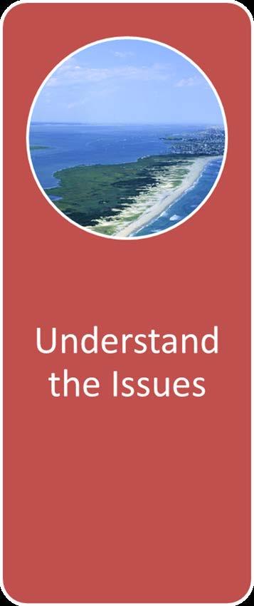
2 Coastal Community Resiliency Progression Understand the Issues Assess Risk and Vulnerability Plan for the Future Implement and Adapt

3 Photo credit: N. Psuty

4 National Assessment of Coastal Vulnerability to Sea-Level Rise Regional factors will influence relative sea level rise for specific coastlines. Graphic from USGS

5 Rising sea level is a physical reality that is impacting the New Jersey and the entire Mid-Atlantic coastline. Predicted future rates are expected to increase to 12 mm/yr (or 0.5 in/yr). This means that by 2050 sea level rise is expected to rise by approximately 1 foot and by 2100 sea level rise is projected to rise about 3 feet along the Jersey shore. The mean sea level trend over the past century is 3.99 millimeters/year (0.15 in/yr) which is equivalent to a change of 1.31 feet in 100 years. Graphic Credit: NOAA


6 Projection of sea level rise from 1990 to 2100, based on temperature projections for different Green House Gas emissions scenarios SOURCE: NRC 2010 Vermeer and Rahmstorf (2009).
7 SLR Scenarios R. Lathrop, R. Kopp and M. Kaplan 2050 Projection Low High Higher NOAA Average RU Miller/Kopp (2013) Mean of NOAA and M/K Consensus Values CFE Values: % Chance of SLR exceeding this value 85% 8% 0.5% 2100 Projection Low High Higher NOAA Average RU Miller/Kopp (2013) Mean NOAA and M/K Consensus Values CFE Values: % Chance of SLR exceeding this value 80% 10% 0.8% Available at NJAdapt.org


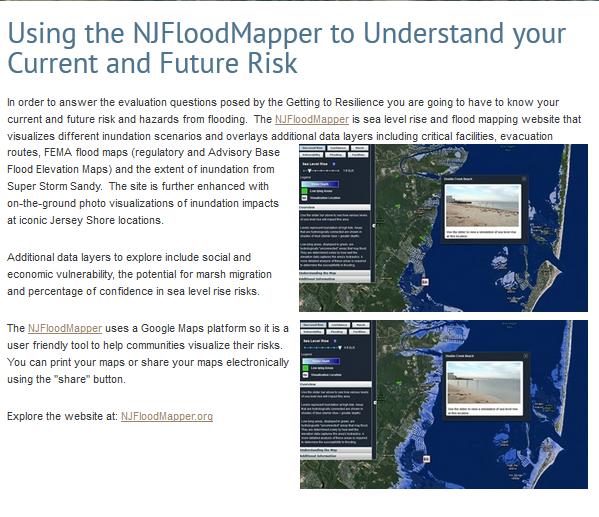
8 Information and tools to support place-based decision-making

9 Situation Hazard Time Period System Exposure Sensitivity/ Susceptibility Resilience Adaptive Capacity Potential for Impact/loss (assets at risk) Vulnerability Graphic adapted from North Atlantic Coast Comprehensive Study U.S. Army Corps of Engineers Coastal Storm Risk Management Planning Center of Expertise Managed Adaptation

10 Workshop Survey Results: The audience of coastal decision makers highlighted their perceived need for place-based information and decision support tools to inform land use planning, floodplain management and emergency management in the face of accelerating sea level rise.
11
12 Applying a Instructional Systems Design Model Analyze Audience Design Product Develop Product Launch Product Evaluate Product & Process Front-end Evaluation (assess users needs & desires for improved decision making) Formative Evaluation (get feedback on design criteria, storyboards, prototypes, beta products, etc., as often as possible & is needed) Summative Evaluation (assess if products work & are useful)

13 Front-End and Formative Evaluation

14 Leveraging federal assets for local application
15
16
17
18 Assessing New Jersey s Exposure and Vulnerability to Sea Level Rise and Coastal Flooding To help meet the needs of local governments interested in enhancing coastal resiliency in their communities, Rutgers University developed the Coastal Flooding Exposure (CFE) Assessment and the NJDEP developed the Coastal Vulnerability Index (CVI). As the graphic below illustrates, the CFE strictly maps flooding exposure with the intention for later use in the assessment of vulnerability as a separate step. The CVI combines aspects of environmental vulnerability (a, b, e & f) along with flooding exposure (c & d). Depending on your intended use, one or the other products may be more applicable. CFE = a + b + c Where CFE = (a) Flood Prone Areas (b) Storm Surge (SLOSH) (c) Nuisance Coastal Flooding
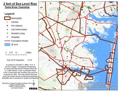
19 NJ Coastal Flooding Exposure (CFE) Objective: An integrated statewide assessment to address questions such as which areas of the state are most exposed to coastal hazards now or might be in the future under sea level rise. The assessment distinguishes three classes of geographic areas : Moderate, High and Extreme exposure. The logic was such that areas exposed to flooding on a more frequent basis were given a higher ranking. Thus the ranking incorporates the probability or likelihood of the area being flooded. For example, even though a Category 3 storm surge has higher flooding elevations, the likelihood of occurrence is lower than a Category 1 storm surge and therefore the Category 3 flood area was given a lower exposure ranking. Extreme exposure areas are those that are exposed to relatively frequent flooding. In addition, the Extreme exposure areas also include those areas subject to the most powerful wave impacts.
20 NJ Coastal Flooding Exposure: projecting into the future Flooding Hazard Present FEMA Special Flood Hazard Areas (SFHA) Extreme: V zone High: 1% A zone Moderate: 0.2% (X) zone Extreme: V zone High: 1% A zone + 2 Moderate: 0.2% (X) zone + 2 Extreme: V zone High: 1% A zone + 5 Moderate: 0.2% (X) zone + 5 SLOSH Storm Surge Extreme: N/A High: SLOSH Cat 1 Moderate: SLOSH Cat 3 Extreme: N/A High: SLOSH Cat Moderate: SLOSH Cat Extreme: N/A High: SLOSH Cat Moderate: SLOSH Cat NOAA/NWS Shallow coastal flooding (SCF) Extreme: SCF High: N/A Moderate: N/A Extreme: SCF + 1 High: SCF + 2 Moderate: SCF Extreme: SCF High: SCF + 5 Moderate: SCF + 7


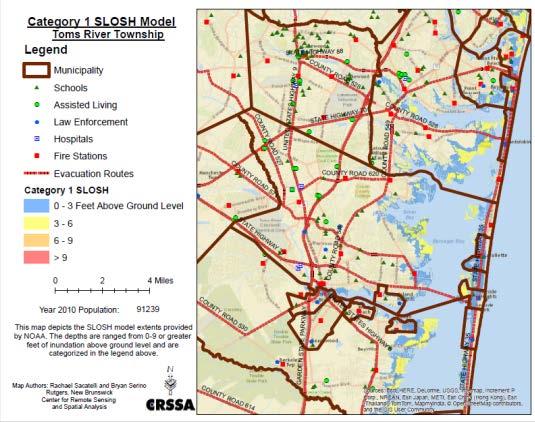
21 NJ Coastal Flooding Exposure - Present

22 NJ Coastal Flooding Exposure Infrastructure Category Area (ac) Area (ac) % change Area (ac) % Change Moderate 197, , , High 148, , , Extreme 234, , , Total 579, , , Moderate (M) High (H) Extreme (E) Total Miles of road affected Major Roads (miles) Evacuation Routes (miles) # of facilities affected Wastewater Treatment Coastal Energy Facilities Schools Fire Stations Law Enforcement Long Term Care / Assisted Living Facilities Hospitals Socially vulnerable populations Total Population (in persons using 2010 Census) 428, , , ,651 Zero Vehicle Households (persons 2010 Census) 26,642 29,549 6,007 62,198 Limited English Proficiency (persons 2010 Census) 69,262 50,513 10, ,967 Over 65 years in age (persons 2010 Census) 52,121 39,420 22, ,147 Known Contaminated Sites (NJDEP) Active Sites with Confirmed Contamination Total (including pending sites) M-H-E categories combined Property parcels affected # affected $ Land value (in 2013 $) Commercial Properties 20,154 $26,555,293,664 Industrial Properties 3,934 $8,960,318,156 Residential Properties (includes Apartments) 335,873 $129,057,872,992 Total Combined 359,961 $164,573,484,812
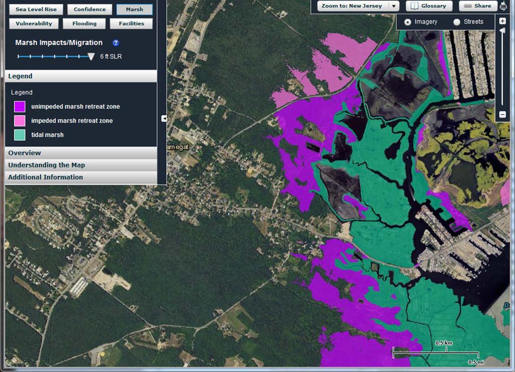
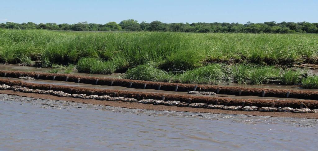
23 Maintaining Green Infrastructure: Coastal Salt Marshes Marsh builds up vertically through accretion Marsh migrates horizontally Tidal Marsh Retreat Graphic from

24 Modeling the Fate of New Jersey s Salt Marshes Under Future Sea Level Rise
25 Modeling the Fate of New Jersey s Salt Marshes Under Future Sea Level Rise Baseline 1 ft SLR 2 ft SLR 3 ft SLR DESCRIPTION % % % acres acres change acres change acres change Tidal salt marsh 213, , % 204, % 184, % Unimpeded marsh retreat 16,631 NA 28,220 NA 39,072 NA Impeded marsh retreat 1,955 NA 2,980 NA 4,764 NA Marsh conversion: uncon. shore % % 19, % Marsh conversion: open water 9, % 9, % 10, %
26
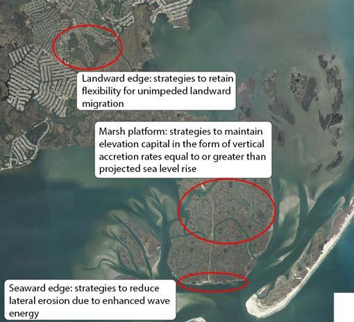
27 Maintaining/restoring salt marshes long term


28 CoastalResilience.org Restoration Explorer for New Jersey

29 Plan for the Future

30 Visualization & Information capture through map/graphics Visualize exposure & sensitivity Preparedness Assessment

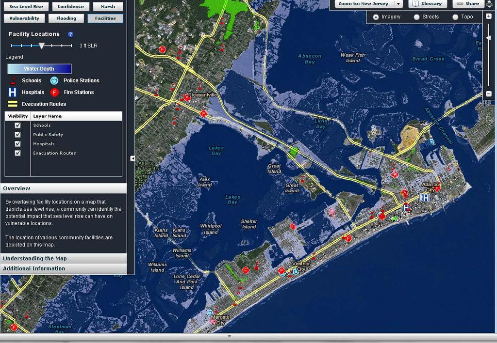
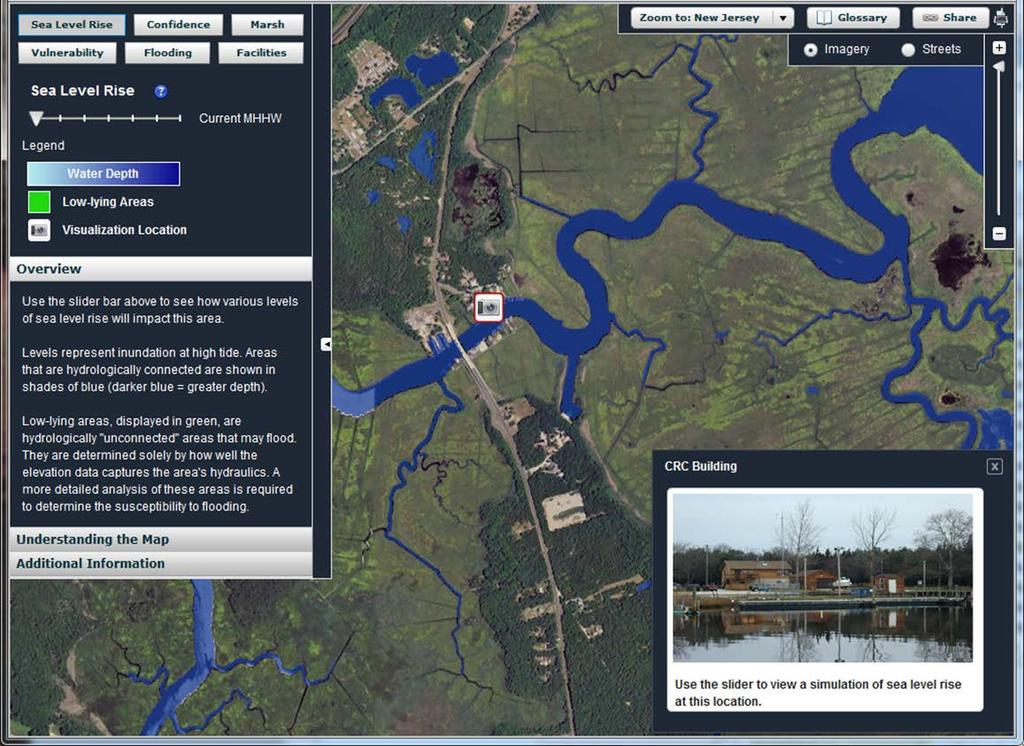
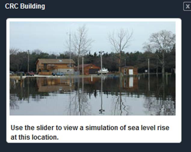
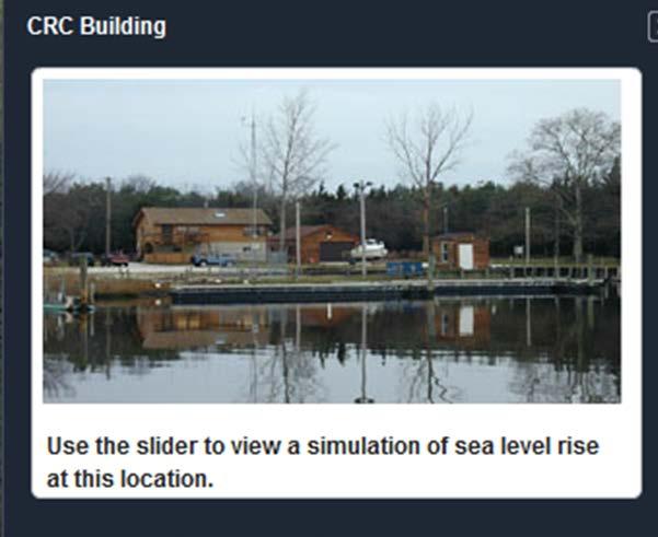
31 NJAdapt Coastal Flood Exposure Profiler

32 map-packs Municipal Profiles


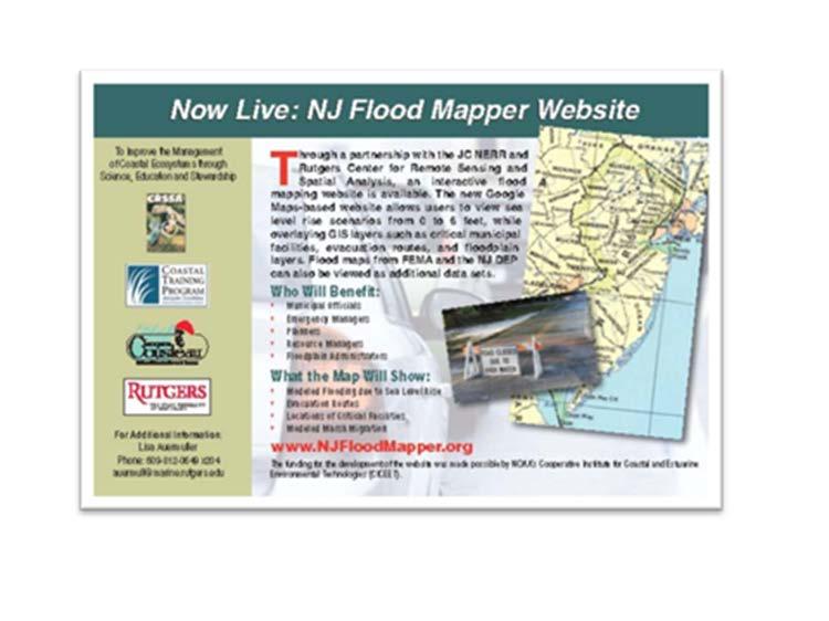
33 Summative Evaluation How useful are these tools? How can they be improved?


34
35 Coastal Community Resiliency Progression Understand the Issues Assess Risk and Vulnerability Plan for the Future Implement and Adapt
 Vulnerability We")

36 Situation Hazard Time Period System Exposure Sensitivity/ Susceptibility Resilience Adaptive Capacity We have a handle on these aspects from a geospatial perspective Potential for Impact/loss (assets at risk) Vulnerability We have a much weaker geospatial information base on aspects of resiliency Graphic adapted from North Atlantic Coast Comprehensive Study U.S. Army Corps of Engineers Coastal Storm Risk Management Planning Center of Expertise Managed Adaptation

37 Assessing Sensitivity Jie Gong of Rutgers School of Engineering is employing mobile LiDAR to map building footprints, elevation and post-storm damage to inform rebuilding and recovery efforts

38
39 Closing Thoughts: Information Our efforts at developing geospatial information and tools relevant for place-based decision-making The NJ Coastal Flood Exposure assessment represents one approach at assessing coastal flood hazard statewide. While we have a good handle on mapping coastal flood hazard exposure, we have a ways to go on assessing sensitivity and adaptive capacity: 2 key aspects of resilience. Maintaining NJ s Salt Marsh long term will require consideration of both seaward edge erosion, vertical accretion as well as landward progression
40 Closing Thoughts: Tools WebGIS tools, such as NJFloodMapper, can provide access to critical place-based information on coastal flood exposure and potential vulnerability. Leveraging national-scale effort with locally-refined geospatial data and functionality is a good model. Providing a local scale municipal focus Adding local data and functionality requested by the community The user-centered design process was central to that elusive goal of virtual accessibility. Fostered connection to target audience. Promoted greater acceptance once tool was released. Even with great tools still need a personal touch through in-the-field outreach and assistance
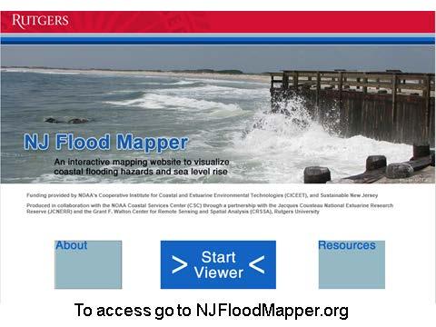
41 Key Websites: Coastal Flood Exposure Profiler Njadapt.org NJFlood Mapper: visualizing SLR NJFloodMapper.org Getting To Resilience: A Community Planning Evaluation Tool Prepareyourcommunitynj.org NJ Climate Adaptation Alliance Climatechange.rutgers.edu
Sea Level Rise in New York:
 Sea Level Rise in New York: Vulnerabilities and Methods of Analysis Westchester Municipal Planning Federation 2017 Land Use Training Institute April 5, 2017 Anjali Sauthoff What is Sea Level Rise? Image
FEMA s National Risk Index
 FEMA s National Risk Index Agenda National Risk Index (NRI) Background NRI Working Groups Calculating and NRI Hazard Data Resilience Score Social Vulnerability and Resilience Data Built Environment Data
A Salt Marsh Advancement Zone Assessment of West Haven, Connecticut
 A Salt Marsh Advancement Zone Assessment of West Haven, Connecticut Front cover image: Open space and unprotected parcels critical to the conservation of marsh advancement corridors in West Haven; from
Transportation Vulnerability and Risk Assessment Pilot. American Planning Association Monday, April 16, 2012
 Transportation Vulnerability and Risk Assessment Pilot American Planning Association Monday, April 16, 2012 Goal The goal of Adapting to Rising Tides is to increase preparedness and resilience of Bay Area
CITY OF PORTSMOUTH, NEW HAMPSHIRE
 TIDES TO STORMS PREPARING FOR NEW HAMPSHIRE S FUTURE COAST Assessing Risk and Vulnerability of Coastal Communities to Sea Level Rise and Storm Surge Seabrook - Hampton Falls Hampton - North Hampton Rye
BOROUGH OF HIGHLANDS STRATEGIC RECOVERY PLANNING REPORT. September 2014
 BOROUGH OF HIGHLANDS September 2014 Why do a Strategic Recovery Planning Report? (SRPR) To access state $$ for plans/ordinance re-writing To assist in decision-making To educate about risks & vulnerability
Louisiana s Strategic Adaptations for Future Environments (LA SAFE): Applicability to Gulf Coastal States
: Applicability to Gulf Coastal States") Louisiana s Strategic Adaptations for Future Environments (LA SAFE): Applicability to Gulf Coastal States HUD Definition of Resilience the ability to anticipate, prepare for, and adapt to changing conditions
Louisiana s Strategic Adaptations for Future Environments (LA SAFE): Applicability to Gulf Coastal States HUD Definition of Resilience the ability to anticipate, prepare for, and adapt to changing conditions
Impact of Sea Level Rise on Roadway Design. Paul Carroll, PE
 Impact of Sea Level Rise on Roadway Design Paul Carroll, PE September 14, 2016 State of Maryland Action Executive Order by Gov. O Malley established the Maryland Commission on Climate Change (MCCC) - 2007
Climate Change Impacts on Joint Riverine and Coastal Flooding on Calleguas Creek in Ventura County, CA
 Climate Change Impacts on Joint Riverine and Coastal Flooding on Calleguas Creek in Ventura County, CA James Gregory, James Jackson (ESA) Lily Verdone (TNC) FMA, September 8, 2016 Project Overview Coastal
Using LIDAR to monitor beach changes: Goochs Beach, Kennebunk, Maine
 Maine Geologic Facts and Localities February, 2010 Using LIDAR to monitor beach changes: Goochs Beach, Kennebunk, Maine 43 o 20 51.31 N, 70 o 28 54.18 W Text by Peter Slovinsky, Department of Agriculture,
Creating a Resilient Community. The City of Satellite Beach Community Resiliency Project
 Creating a Resilient Community The City of Satellite Beach Community Resiliency Project Resources www.climate.gov www.climate.nasa.gov Agenda Creating A Resilient Community Project Overview Resiliency
Bay of Fundy: Tides and Sea Level Rise SC 211, June 2, Gary Oberts
 Bay of Fundy: Tides and Sea Level Rise SC 211, June 2, 2015 - Gary Oberts 1. 2. 3. 4. Causes of Sea Level Rise* Warming expands water (~50%) Glacier/ice sheet melt (~50%) 1947 2009 Wilkins Ice Shelf, Antarctica
Sea Level Rise Threats to Energy Infrastructure
 Sea Level Rise Threats to Energy Infrastructure A Surging Seas Brief Report by Climate Central April 19, 2012 Ben Strauss Remik Ziemlinski Summary Sea level rise from global warming is well on the way
DRAFT. Coastal Resilience Index: A Community Self-Assessment. A Guide to Examining How Prepared Your Community Is for a Disaster
 Florida Pilot Test Coastal Resilience Index: A Community Self-Assessment A Guide to Examining How Prepared Your Community Is for a Disaster Rod Emmer, Louisiana Sea Grant LaDon Swann, Melissa Schneider,
Climate Change and Chesapeake Bay Habitats
 Climate Change and Chesapeake Bay Habitats Donna Marie Bilkovic STAC Chesapeake Bay Forage Base Workshop 12 November 2014 http://www.chesapeake.org/stac/ Virginia Institute of Marine Science www.ccrm.vims.edu
CITY OF OCEAN CITY COMMUNITY RESILIENCE PLAN
 CITY OF OCEAN CITY COMMUNITY RESILIENCE PLAN Table of Contents Introduction... 1 What is Community Resilience?... 1 Sandy s Effects on the Coastline... 3 Performance of Existing Coastal Defenses... 3 Major
Miami-Dade Water & Sewer Department. Miami-Dade Water and Sewer Department 1
 Miami-Dade Water & Sewer Department Miami-Dade Water and Sewer Department www.miamidade.gov/water 1 Miami-Dade Water and Sewer Department (WASD) Largest Water & Sewer Utility in the Southeastern United
Increasing the Coastal Resilience of Vulnerable Wastewater Infrastructure on Cape Cod and the Islands Two Case Studies
 Increasing the Coastal Resilience of Vulnerable Wastewater Infrastructure on Cape Cod and the Islands Two Case Studies Anastasia Rudenko GHD Marc Drainville GHD Guy Campinha Town of Wareham, MA June 2017
Causes of Sea Level Rise*
 1. 2. 3. 4. Causes of Sea Level Rise* Warming expands water (~50%) Glacier/ice sheet melt (~50%) 1947 2009 Wilkins Ice Shelf, Antarctica South Cascade Glacier, WA 1960 and 2004 (NAS, 2008) *Percentages
The newly updated and comprehensive SWMP shall:
 RFQ SCOPE OF SERVICES 2.1 Project Purpose The City of Miami, ( City ) is seeking professional engineering services from a qualified firm for the purpose of planning and developing a newly updated and comprehensive
U.S. Energy Sector Vulnerabilities to Climate Change and Extreme Weather
 U.S. Energy Sector Vulnerabilities to Climate Change and Extreme Weather NASEO 2013 Annual Meeting September 17, 2013 Jonathan Pershing, Ph.D. Deputy Assistant Secretary for Climate Change Policy and Technology,
Climate Change, Human Activities, and the State of New Jersey. Michael J. Kennish Institute of Marine and Coastal Sciences Rutgers University
 Climate Change, Human Activities, and the State of New Jersey Michael J. Kennish Institute of Marine and Coastal Sciences Rutgers University New Jersey Climate and Environmental Change Conclusions from
Integrating Climate Change & Water Supply Planning In Southeast Florida
 Integrating Climate Change & Water Supply Planning In Southeast Florida Updated September 9, 2014 ABOUT THE RCAP IMPLEMENTATION GUIDE DOCUMENT SERIES This Compact Guidance Document is one in a series of
Preparing for Tomorrow s High Tide: Source Water Implications of Sea Level Rise in Delaware
 Preparing for Tomorrow s High Tide: Source Water Implications of Sea Level Rise in Delaware Susan E. Love, Planner IV Delaware Coastal Programs Presentation for the Source Water Assessment and Protection
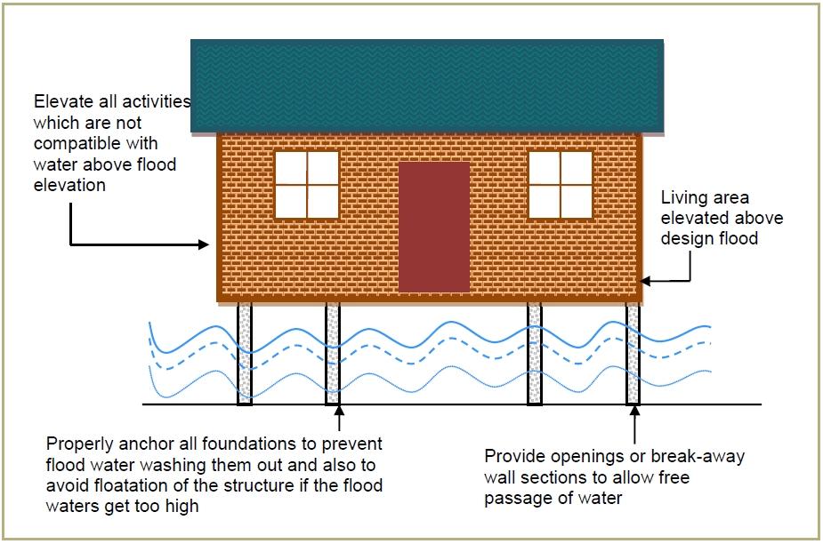
2. Does not require, involve or include any additions to, or repair or modification of, the existing foundation.
 SECTION 3109 STRUCTURES SEAWARD OF A COASTAL CONSTRUCTION CONTROL LINE 3109.1 General. The provisions of this section shall apply to the design and construction of habitable structures, and substantial
Kentucky Dam Safety and Floodplain Compliance
 Kentucky Dam Safety and Floodplain Compliance Celebrating 10 years KAMM Conference September 10, 2014 Brian Shane Cook, PE, LSIT Kentucky Division of Water (502) 564-3410 ext 4822 Shane.Cook@ky.gov WHY
CHAPTER 7. San Dieguito River Flooding Adaptation
 CHAPTER 7 San Dieguito River Flooding Adaptation This chapter includes a range of adaptation measures to address vulnerabilities from flooding along the San Dieguito River, including the river valley,
CLIMATE CHANGE ADAPTATION IN MASSACHUSETTS
 CLIMATE CHANGE ADAPTATION IN MASSACHUSETTS Kathleen Baskin, Director of Water Policy June 3, 2013 MA Global Warming Solutions Act of 2008 Mitigation Reduce greenhouse gas emissions below 1990 levels by
Sea Level Rise Adaptation Strategy for San Diego Bay. Brian Holland, AICP, Climate Program Manager City of San Diego EESTF June 29, 2011
 Sea Level Rise Adaptation Strategy for San Diego Bay Brian Holland, AICP, Climate Program Manager City of San Diego EESTF June 29, 2011 Five Milestones for Climate Adaptation Adapted from Preparing for
Challenge 2: Community Resilience in Dania Beach
 University of New Orleans ScholarWorks@UNO Coastal Resilience Workshop Coastal Resilience Workshop 2015 Oct 27th, 1:00 PM - 1:15 PM Challenge 2: Community Resilience in Dania Beach Samantha Danchuk Environmental
Coastal Resilience Grant Program
 Coastal Resilience Grant Program MA Office of Coastal Zone Management Dave Janik, South Coastal Regional Coordinator Tricia Bowie, Coastal Resiliency Specialist Rebecca Haney, Coastal Geologist Support
Vulnerabilities to Climate Change Impacts and Strengthening Disaster Risk Management in East Asian Cities
 2008 Primer Reducing Vulnerabilities to Climate Change Impacts and Strengthening Disaster Risk Management in East Asian Cities I/ CITY DESCRIPTION New York City comprises five boroughs, each of which is
Flood Risk Management on the Elwha: Case Study of the Federal Levee Modification Project
 Flood Risk Management on the Elwha: Case Study of the Federal Levee Modification Project US Army Corps of Engineers Zac Corum, PE, Hydraulic Engineer Travis Ball, PE, CFM, Hydraulic Engineer Seattle District
Mitigation Plan Mission, Goals and Action Items
 Section 4: Mitigation Plan Mission, Goals and Action Items Introduction... 2 Mission... 2 Mitigation Plan Goals... 2 Natural Hazard Mitigation Plan Action Items... 3 Coordinating Organization... 4 Partner
PRINCESS ANNE DISTRICT STORMWATER PROJECTS
 PRINCESS ANNE DISTRICT STORMWATER PROJECTS Topics o o o o o Sea Level Rise and the Southern Watersheds Ashville Park Sherwood Lakes Kingston Estates Drainage Operations & Maintenance in the Southern Watersheds
Adapting to Rising Tides
 Adapting to Rising Tides A regional program that uses findings, processes, tools and relationships built by ART and its partners to lead and support efforts that increase the resilience of San Francisco
East St. Tammany Storm Surge Protection Project Request
 East St. Tammany Storm Surge Protection Project Request Submitted to Coastal Protection & Restoration Authority of Louisiana (CPRA) August 2015 Contact Information: Thomas Nolan Thompson The East St. Tammany
Climate Adaptation & Disaster Risk Reduction Building Coastal Resilience
 Climate Adaptation & Disaster Risk Reduction Building Coastal Resilience Dr. Michael Beck & Dr. Borja Reguero The Nature Conservancy & Univ. of California Santa Cruz www.nature.org & www.coastalresilience.org
Louisiana Watershed Resiliency Study (LaWRS) Shona Gibson February 27, 2017
 Shona Gibson February 27, 2017") Louisiana Watershed Resiliency Study (LaWRS) Shona Gibson February 27, 2017 1 Background In response to flood events in 2016, watershed analysis and planning became a priority for state and local leaders
Louisiana Watershed Resiliency Study (LaWRS) Shona Gibson February 27, 2017 1 Background In response to flood events in 2016, watershed analysis and planning became a priority for state and local leaders
The City of Lewes Hazard Mitigation and Climate Adaptation Action Plan
 The City of Lewes Hazard Mitigation and Climate Adaptation Action Plan June 2011 The City of Lewes Hazard Mitigation and Climate Adaptation Action Plan A community guide developed to improve public safety,
GUIDANCE FOR INCORPORATING SEA LEVEL RISE INTO CAPITAL PLANNING IN SAN FRANCISCO: ASSESSING VULNERABILITY AND RISK TO SUPPORT ADAPTATION
 GUIDANCE FOR INCORPORATING SEA LEVEL RISE INTO CAPITAL PLANNING IN SAN FRANCISCO: ASSESSING VULNERABILITY AND RISK TO SUPPORT ADAPTATION Prepared by the City and County of San Francisco Sea Level Rise
From: John D. Hines, P.E. Re: Old Dominion University Campus Master Plan Sea Level Rise Narrative
 Transportation Land Development Environmental S e r v i c e s Two Columbus Center 4500 Main Street, Suite 400 Virginia Beach, Virginia 23462 Telephone 757 490 0132 Fax 757 490 0136 Memorandum To: File
Environmental Protection (NJDEP) The Louis Berger Group, Inc.
 The Louis Berger Group, Inc.") Hydraulic Modeling for Preliminary Evaluation of Potential Flooding Impacts for Various Dredging, Capping and Armoring Scenarios of The Lower Passaic River Restoration Abdulai Fofanah, PE, D.WRE, CFM Murat
Hydraulic Modeling for Preliminary Evaluation of Potential Flooding Impacts for Various Dredging, Capping and Armoring Scenarios of The Lower Passaic River Restoration Abdulai Fofanah, PE, D.WRE, CFM Murat
Climate Adaptation & California Native American Tribes
 Climate Adaptation & California Native American Tribes Contact Information Please call or email us if you d like us to walk through this information and if you have questions, comments, or concerns. For
Climate Change Adaptation Strategies for Infrastructure Managers
 Climate Change Adaptation Strategies for Infrastructure Managers Green Streets and Highways Conference November 17, 2010 Butch Wlaschin Office of Asset Management Federal Highway Administration U.S. Department
Hydra, Tunisia. Local progress report on the implementation of the 10 Essentials for Making Cities Resilient ( )
") Hydra, Tunisia Local progress report on the implementation of the 10 Essentials for Making Cities Resilient (2013-2014) Name of focal point: Fathi M Organization: La ville de hydra Title/Position: Employee
Hydra, Tunisia Local progress report on the implementation of the 10 Essentials for Making Cities Resilient (2013-2014) Name of focal point: Fathi M Organization: La ville de hydra Title/Position: Employee
Sea-level Rise Science and Decision Making in an Uncertain Future. Rob Thieler U.S. Geological Survey Woods Hole, MA
 Sea-level Rise Science and Decision Making in an Uncertain Future Rob Thieler U.S. Geological Survey Woods Hole, MA Concepts Sea-level rise is one of the most certain impacts of climate change. There is
GREAT BAY REGION, NEW HAMPSHIRE
 CLIMATE RISK IN THE SEACOAST Assessing Vulnerability of Municipal Assets and Resources to Climate Change Rollinsford Dover Madbury Durham Newmarket Newfields Exeter Stratham Greenland Newington GREAT BAY
Resilient Water and Wastewater Systems
 Resilient Water and Wastewater Systems June 2017 Ryan Berni Deputy Mayor City of New Orleans Patrick Schultz Principal & General Manager, Resource Optimization Veolia New Orleans A challenging delta landscape
NEW HAMPSHIRE COASTAL RISK AND HAZARDS COMMISSION. Preparing New Hampshire for Projected Storm Surge, Sea-Level Rise, and Extreme Precipitation
 NEW HAMPSHIRE COASTAL RISK AND HAZARDS COMMISSION Preparing New Hampshire for Projected Storm Surge, Sea-Level Rise, and Extreme Precipitation Final Report and Recommendations November 2016 The final report
CITY OF MOUNTAIN VIEW
 CITY OF MOUNTAIN VIEW Incorporate Climate Change Adaptation in Municipal Scale, Urban Watershed Planning at the City of Mountain View Raymond Wong, PhD, PE, LEED AP Lisa Au, PE Floodplain Management Association
Kilbirnie Town Centre Plan Working Paper. Assessing the implications of sea level rise Kilbirnie Town Centre
 Kilbirnie Town Centre Plan Working Paper Assessing the implications of sea level rise Kilbirnie Town Centre September 2009 1 Contents 1. Introduction... 3 2. Objectives of the Study... 3 3. Methodology
FEMA s Mitigation Support for Resiliency: Innovative Drought and Flood Mitigation Projects
 FEMA s Mitigation Support for Resiliency: Innovative Drought and Flood Mitigation Projects Jordan Williams, CFM Eric Kenney, PE, CFM May 4, 2017 2 Hazard Mitigation Purpose: Research climate resilient
Mississippi Coastal Improvements Program (MsCIP) Comprehensive Barrier Island Restoration Plan
 Comprehensive Barrier Island Restoration Plan") Mississippi Coastal Improvements Program (MsCIP) Comprehensive Barrier Island Restoration Plan BOEM Gulf of Mexico Sand Management Working Group October, 205 Justin McDonald, P.E. US Army Corps of Engineers
Mississippi Coastal Improvements Program (MsCIP) Comprehensive Barrier Island Restoration Plan BOEM Gulf of Mexico Sand Management Working Group October, 205 Justin McDonald, P.E. US Army Corps of Engineers
ALABAMA COASTAL AREA MANAGEMENT PROGRAM
 ALABAMA COASTAL AREA MANAGEMENT PROGRAM SECTION 309 Enhancement Grant Program ASSESSMENT & STRATEGY September 1, 2015 ALABAMA DEPARTMENT OF CONSERVATION & NATURAL RESOURCES State Lands Division, Coastal
Jakarta, Indonesia. Local progress report on the implementation of the 10 Essentials for Making Cities Resilient (First Cycle)
") Jakarta, Indonesia Local progress report on the implementation of the 10 Essentials for Making Cities Resilient (First Cycle) Name of focal point: Anita Boje Organization: Jakarta Capital City Title/Position:
Jakarta, Indonesia Local progress report on the implementation of the 10 Essentials for Making Cities Resilient (First Cycle) Name of focal point: Anita Boje Organization: Jakarta Capital City Title/Position:
Jamestown S Klallam Tribe
 Adaptation Plan Addendum: Two additional Key Areas of Concern Jamestown S Klallam Tribe September 2013 Acknowledgements Thank You This project would not have been successful with out the combined efforts
City of Cambridge Climate Change Vulnerability Assessment and Adaptation Plan
 City of Cambridge Climate Change Vulnerability Assessment and Adaptation Plan September 11, 2013 John Bolduc, Environmental Planner Project Manager, City of Cambridge Nathalie Beauvais, Int'l Assoc. AIA,
America s Climate Choices Adaptation A Challenge to the Transportation Industry
 America s Climate Choices Adaptation A Challenge to the Transportation Industry November 3, 2010 TRB Webinar H. G. Schwartz, Jr. 1 Major Factors Affecting Climate 2 MITIGATION Measures to reduce Greenhouse
Overview of National and State erosion management reviews & reports
 Overview of National and State erosion management reviews & reports National Research Council: Managing Coastal Erosion 1990 Heinz Center: Evaluation of Erosion Hazards 2000 Maryland: Shore Erosion Task
Adapting to Rising Sea Level: A Florida Perspective
 Adapting to Rising Sea Level: A Florida Perspective Randall W. Parkinson RW Parkinson Consulting, Inc., 2018 Melbourne Ct., Suite 205, Melbourne, Florida 32901, USA Abstract. Global climate change and
New Jersey Forest Stewardship Program Spatial Analysis Project Map Products And Data Layers Descriptions
 New Jersey Forest Stewardship Program Spatial Analysis Project 2007 Map Products And Data Layers Descriptions 01/07 NJ Forest Stewardship Program (FSP) Spatial Analysis Project (SAP) Methodology Project
Funding a More Holistic Effort - Bringing In New Partners and Resources Case Study: San Mateo County Shoreline Vulnerability Assessment
 Funding a More Holistic Effort - Bringing In New Partners and Resources Case Study: San Mateo County Shoreline Vulnerability Assessment Craig Conner Flood Risk Management Program Manager 3 December 2015
Atlantic Coast of New York East Rockaway Inlet to Rockaway Inlet and Jamaica Bay, NY
 Atlantic Coast of New York East Rockaway Inlet to Rockaway Inlet and Jamaica Bay, NY Draft Reformulation Public Information October 2016 US Army Corps of Engineers Presentation Outline Project Overview
Showing Only Sections Changed 6 th Edition FBC (2017) from 5 th Edition FBC (2015) [changes shown with underline and strike-through]
![Showing Only Sections Changed 6 th Edition FBC (2017) from 5 th Edition FBC (2015) [changes shown with underline and strike-through]](/thumbs/76/74346035.jpg "Showing Only Sections Changed 6 th Edition FBC (2017) from 5 th Edition FBC (2015) [changes shown with underline and strike-through]") Showing Only Sections Changed 6 th Edition FBC (2017) from 5 th Edition FBC (2015) [changes shown with underline and strike-through] This publication reproduces excerpts from the Florida Building Code,
Showing Only Sections Changed 6 th Edition FBC (2017) from 5 th Edition FBC (2015) [changes shown with underline and strike-through] This publication reproduces excerpts from the Florida Building Code,
W. Tobey Ritz MTA Metro-North Railroad, Chief Engineer Capital Engineering New York/New York
 What have we learned about future emergency preparedness from Irene and Sandy W. Tobey Ritz MTA Metro-North Railroad, Chief Engineer Capital Engineering New York/New York Metro North Railroad Storm Surge
Selecting a Temporary Debris Management Site for Effective Debris Removal
 214 10 th International Conference of the International Institute for Infrastructure Resilience and Reconstruction (I3R2) 20 22 May 2014 Purdue University, West Lafayette, Indiana, USA Selecting a Temporary
Building Resilience to Sea Level Rise in SE Florida
 Building Resilience to Sea Level Rise in SE Florida Nichole L. Hefty, Chief Miami-Dade Office of Sustainability Planning Division Dept. of Regulatory and Economic Resources Miami-Dade s Long-Standing Climate
Engineering with Nature for Natural Infrastructure
 Engineering with Nature for Natural Infrastructure Dr. Todd S. Bridges Senior Research Scientist, Environmental Science U.S. Army Engineer Research and Development Center, USACE todd.s.bridges@usace.army.mil
A Sustainable Chesapeake
 A Sustainable Chesapeake BETTER MODELS FOR CONSERVATION Edited by David G. Burke and Joel E. Dunn THE CONSERVATION FUND The case study you have downloaded is highlighted below. Other case studies from
Economic Analysis of Nature-Based Adaptation to Climate Change Ventura County, California
 Climate Change, Ventura County, CA Economic Analysis of Nature-Based Adaptation to Climate Change Ventura County, California Prepared for: The Nature Conservancy 201 Mission Street San Francisco, CA 94105
Climate Change Impact and Adaptation Assessment
 Climate Change Impact and Adaptation Assessment Projected warming (ºF) by NASA center, 2080s minus 1980s averaged across 16 GCMs under the A1B emissions scenario Cynthia Rosenzweig NASA Goddard Institute
SURREY COASTAL FLOOD ADAPTATION STRATEGY (CFAS) Improving Coastal Flood Adaptation Approaches (ICFAA) Stakeholder Workshop
 Improving Coastal Flood Adaptation Approaches (ICFAA) Stakeholder Workshop") SURREY COASTAL FLOOD ADAPTATION STRATEGY (CFAS) Improving Coastal Flood Adaptation Approaches (ICFAA) Stakeholder Workshop Workshop Introductions and Opening Remarks Our objectives for the day To explore
SURREY COASTAL FLOOD ADAPTATION STRATEGY (CFAS) Improving Coastal Flood Adaptation Approaches (ICFAA) Stakeholder Workshop Workshop Introductions and Opening Remarks Our objectives for the day To explore
Flooded Bus Barns and Buckled Rails: Public Transportation and Climate Change Adaptation
 Flooded Bus Barns and Buckled Rails: Public Transportation and Climate Change Adaptation Tina Hodges Federal Transit Administration September 22, 2011 Tina.Hodges@dot.gov 1 Key Themes Proactive instead
Lisa B. Beever, PhD, AICP Estero Bay Agency on Bay Management Cela Tega December 12, 2016
 Lisa B. Beever, PhD, AICP Estero Bay Agency on Bay Management Cela Tega December 12, 2016 National Estuary Programs Each of the 28 NEP logos represents broad local partnerships which include citizens,
Climate Change Adaptation and the Department of Defense. Maureen Sullivan Director, Environmental Management March 8, 2012
 Climate Change Adaptation and the Department of Defense Maureen Sullivan Director, Environmental Management March 8, 2012 Quadrennial Defense Review (QDR) 2010 Rebalances US military capabilities and reforms
Building Resilient Communities - Low Impact Development and Green Infrastructure Strategies
 Building Resilient Communities - Low Impact Development and Green Infrastructure Strategies October 24, 2013 Bridgewater State University E. Heidi Ricci Senior Policy Analyst Mass Audubon Shaping the Future
Report to N.C. Legislative Commission on Global Climate Change March 15, 2010
 Summary of March 2010 Planning for North Carolina s Future: Ask the Climate Question Climate Change Adaptation Workshop hosted by N.C. Interagency Leadership Team And Next Steps Report to N.C. Legislative
CHAPTER 5 RI CRMC Coastal Hazard Application Guidance
 CHAPTER 5 RI CRMC Coastal Hazard Application Guidance Overview of Process The steps presented below provide guidance for applicants to address Coastal Hazards for selected projects in the design and permitting
Ewan Hyslop Developing a climate change risk assessment for cultural heritage sites in Scotland
 Ewan Hyslop ewan.hyslop@hes.scot Developing a climate change risk assessment for cultural heritage sites in Scotland Historic Environment Scotland Scottish Government Non-Departmental Public Body Direct
OVERVIEW CAPACITY & CONDITION
 OVERVIEW Over 18,000 sites and an associated 22 million acres of land are related to the primary hazardous waste programs that comprise much of the nation s hazardous waste infrastructure, and more than
A State Policy Framework for Adaptation to Climate Change
 A State Policy Framework for Adaptation to Climate Change James Murley, Director Barry N. Heimlich Nick Bollman* Center for Urban and Environmental Solutions at Florida Atlantic University *In Memoriam
Protecting Open Space & Ourselves
 Protecting Open Space & Ourselves Reducing Flood Risk in the Gulf of Mexico Through Strategic Land Conservation NATURE.ORG/GULF PROTECTING OPEN SPACE & OURSELVES: REDUCING FLOOD RISK IN THE GULF OF MEXICO
Resiliency in Flagstaff, Arizona: A Community Commitment. Nicole Antonopoulos Woodman, City of Flagstaff
 Resiliency in Flagstaff, Arizona: A Community Commitment Nicole Antonopoulos Woodman, City of Flagstaff 1 Flagstaff, Arizona Founded in 1882 Population 67,500 Elevation 7,000 ft / 2,130 m Largest contiguous
Practical Needs and Approaches for Water Resources Adaptation to Climate Uncertainty
 Practical Needs and Approaches for Water Resources Adaptation to Climate Uncertainty Rolf Olsen, PhD Senior Lead, Climate Change Institute for Water Resources U.S. Army Corps of Engineers Alexandria, Virginia
Ordinance No Lot Surface Drainage
 Ordinance No. 35-2008 - Lot Surface Drainage The Township has adopted a new Lot Surface Drainage Ordinance which amends Chapter 170, Article IX, Subdivision and Site Plan Review by adding a new Section
U.S. Army Corps of Engineers Mobile District
 U.S. Army Corps of Engineers Mobile District General Permit for Living Shorelines in Alabama Sandy P. Gibson Regulatory Specialist, Coastal Alabama Regulatory Division, Mobile District US Army Corps of
CITY OF PACIFICA 170 Santa Maria Avenue Pacifica, California
 CITY OF PACIFICA 170 Santa Maria Avenue Pacifica, California 94044-2506 www.cityofpacifica.org MAYOR Karen Ervin MAYOR PRO TEM Sue Digre Scenic Pacifica Incorporated Nov. 22, 1957 COUNCIL Mary Ann Nihart
CHNEP/SWFRPC Climate Ready Programs
 CHNEP/SWFRPC Climate Ready Programs Southwest Florida is currently experiencing climate change. The natural setting of southwest Florida coupled with extensive overinvestment in the areas closest to the
By Sea, And by Air. Port Administration and Legal Issues Seminar. Brenda L. Enos, CHMM, REM Massachusetts Port Authority April 11, 2013
 By Sea, And by Air. Port Administration and Legal Issues Seminar Brenda L. Enos, CHMM, REM Massachusetts Port Authority April 11, 2013 1 OVERVIEW Basics of Climate Change What are we doing about it A Bit
Maryland s Living Shorelines Program. Bhaskaran Subramanian February 27, 2015
 Maryland s Living Shorelines Program Bhaskaran Subramanian February 27, 2015 1 Erosion & traditional approaches Living shorelines- what is it? Maryland s Living Shorelines program LS Law Products Funding-
CLIMATE CHANGE RESILIENCY AND STORM WATER MANAGEMENT: A FEDERAL SITE'S PERSPECTIVE
 drhgfdjhngngfmhgmghmghjmghfmf IAFSM 2016 ANNUAL CONFERENCE TINLEY PARK, ILLINOIS CLIMATE CHANGE RESILIENCY AND STORM WATER MANAGEMENT: A FEDERAL SITE'S PERSPECTIVE PETER LYNCH Environmental Engineer Argonne
Climate Change Impacts in Washington State
 Climate Change Impacts in Washington State Lara Whitely Binder Climate Impacts Group College of the Environment University of Washington Evergreen College January 13, 2016 Climate Science in the Public
THE COMMUNITY RESILIENCY INITIATIVE Planning for Adaptation: Adaptation Action Areas. Sean Reiss Division of Community Development
 THE COMMUNITY RESILIENCY INITIATIVE Planning for Adaptation: Adaptation Action Areas Sean Reiss Division of Community Development COMMUNITY RESILIENCY PROJECT GOALS Follow the lead of local governments
The Northern Waterfront Seawall History and Earthquake Performance Waterfront Plan Working Group Meeting April 13, 2016
 The Northern Waterfront Seawall History and Earthquake Performance Waterfront Plan Working Group Meeting April 13, 2016 Steven Reel, PE - Project Manager, Engineering Division, Port 1 The Northern Waterfront
Rocky Hill. Challenges
 Rocky Hill Rocky Hill is located in the southern portion of the Capitol Region. Its land area covers 13.9 square miles with an estimated 2010 Census population of 19,703. Elevation in Rocky Hill ranges
SECTION 6: MITIGATION STRATEGIES
 SECTION 6: MITIGATION STRATEGIES This section presents mitigation actions for Onondaga County to reduce potential exposure and losses identified as concerns in the Risk Assessment portion of this plan.