Watershed Management And Modeling. Gridded Surface Subsurface Hydrologic
|
|
|
- Adam Williamson
- 6 years ago
- Views:
Transcription
1 Gridded Surface Subsurface Hydrologic Analysis


2 What is GSSHA? GSSHA is a complete watershed simulation and management model used for hydrologic, hydraulic, sediment and quality simulation and management. GSSHA is a fully distributed, physics based model that utilizes a grid to represent the watershed. GSSHA is a product of the US Army ERDC Maintained Supported Distributedib GSSHA is a direct descendent of the surface water hydrologic model CASC2D developed at Colorado State University. The original version of GSSHA is the result of my dissertation work at University of Connecticut. Downer, C. W. Identification and Modeling of Important Stream Flow Producing Processes in Watersheds, PhD Dissertation, University of Connecticut, 2002.

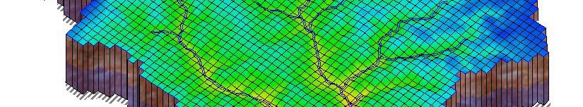
3 How does GSSHA Work? GSSHA works on a uniform spatial grid. Basic equations of mass, energy, and momentum conservation are solved with finite volume and finite difference techniques. Point processes are solved at the grid level. Point responses are integrated to get the system response. Computational Grid Cascading planes Cascading planes in two dimensions CASC2D


4 Why Does This Matter? Spatial variability. Physically based parameters.


5 Spatial Variability Explicitly include spatially heterogeneous features, such as varying land use, source areas, BMPs, etc.
6 Physically Based Parameters Values are based on physical conditions in the computational element. requires less calibration data extendible beyond calibration range The tie to physical conditions provides a means to logically alter parameters based on changing gconditions. land use changes project alternatives climate change


7 What GSSHA Can Do? Surface water hydrology Surface Water/Groundwater Interaction ti Surface water quality and TMDL s Sediment Management Contaminant fate/transport in surface water and groundwater and related health risk assessment Watershed Modeling and Management


8 Watershed Management And Modeling Gridded Surface Subsurface Hydrologic Analysis (GSSHA)


9 2D Overland Flow h q q t x y 1/ 2 q S i n dh S fx Sox ; S dx 1 5/3 5/3 1/ 2 d fx d S fy j 1 n fy S oy dh dy


10 1D Stream Network 2 1/ 2/ / 1 2 1/ 1 i f i i i S R A n Q n S o S f x h S x Q t A


11 Infiltration and Evapotranspiration Infiltration Richards Equation 3 primary soil layers infinite subdivisions of each layer Green and Ampt, 1 layer Two layer Green and Ampt w/ Soil Moisture Redistribution Three layer Green and Ampt model with soil moisture accounting Evapotranspiration Deardorff bare earth Penman Montieth
12 Advanced Processes Covered in Next Course Continuous simulations with soil moisture accounting. Groundwater modeling. Surface water/groundwater interaction. Hydraulic structures. Reservoir and detention basins. Embankments. Sediment transport. Constituent transport.


13 Wetland Model Lateral flow through, over vegetation Bi-model flow: Linear transition from Darcian flow at bottom to Manning s flow at overtopping level Lateral flow through peat / muck layer Darcian Flow Vertical infiltration, exfiltration, Lateral Groundwater Infiltration, 2D Groundwater models
14 Rio Grande Wetlands Model
15 How Do I Build a GSSHA Model? GSSHA models are most easily built using the WMS software. Some files must be built with common text editors or spreadsheets. Additional utilities for building file types not supported by WMS are provided on the GSSHA wiki. Once the spatial aspects of the model have been assigned, simple changes to model input may be accomplished by directly editing the project and mapping table files.
16 How Do I Run GSSHA? GSSHA is run from the command line in a Windows Dialogue box. GSSHA can also be run from WMS, which basically calls up a Windows Dialogue box and launches GSSHA for you.

 is a pre")


17 GSSHA and WMS The Watershed Modeling System (WMS) is a pre and post processor for GSSHA and several other hydrologic models, including HEC HMS and HEC 1.

 Physically based, distributed spatial")
 W ) Integrates Models to understand system wide effects")

18 WMS Overview Comprehensive system for watershed modeling Multiple computational models supported Empirically based, lumped parameter models (e.g. HEC HMS, HSPF, TR 20, etc) Physically based, distributed spatial parameter model (GSSHA) Riverine models (e.g. HEC RAS) Reservoir models dl (e.g. CE QUAL W2) W ) Integrates Models to understand system wide effects Multiple data sources to automate model parameter definition With GIS through ESRI s ArcObjects With public data sources through web services Widely used for civil and military applications

19 Watershed Modeling
20 Why use GSSHA? Model floods, water balance, and ecological flows Flexible processes selection tailored to watershed and project characteristics Integrated Process Modeling Changes in one process affect other processes Coupled groundwater, soil moisture, stream, and overland flow models Spatially explicit formulation: can evaluate impacts of where changes occur Location of wetlands addition Location of land use change Physical Process driven model: can simulate fundamental changes in processes such as tile drain removal, addition of wetlands, and changes in land use
21 Why use GSSHA? Integrated Surface and Overland Modeling Stream channels are integrated with the overland and groundwater flow regimes. Allows water in 2D systems to enter/exit the stream channel at correct time and location. Reservoirs are simulated as both channel and overland features. Reservoirs can expand and contract in both the channels and on the overland flow plane. Each physically simulated processes is allowed to interact with p y y p and be affected by the other physical processes. This allows for impacts and changes to be more realistically modeled.
22 Dynamic Reservoir Simulation


23 Why use GSSHA? Explicit Spatial Process Descriptions Spatially varied heterogeneity Explicitly resolve features in the grid Land use Soil type Depressions BMPs Roads Wetlands Track fate of water, sediment, contaminants along flow path Infiltration along path Settling/erosion along path Reactions along path
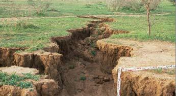
24 Why use GSSHA? Modeling changes in physical processes Converting from tile drained fields to wetlands is a change in the fundamental runoff mechanisms GSSHA simulates the actual runoff processes in their spatial context By simulating the physical processes we are able to model changes to the watershed that include Precipitation events outside the calibration range Changes in fundamental runoff generation mechanisms Changes in runoff transport mechanisms Resulting impacts to nutrient and sediment production and transport


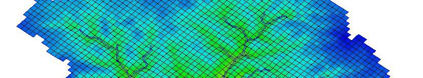
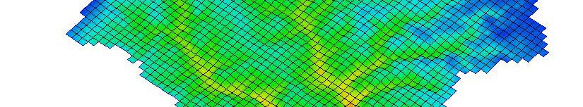
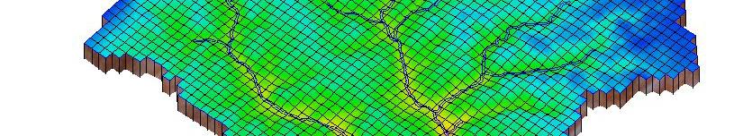
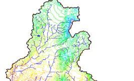
25 Modeling Process Changes: Tile Drains and Wetlands Coon Creek Watershed JD31 Wetlands converted to agriculture Drainage ditch Tile drains Needed information Examine wetland restoration scenarios Assess stream flow impacts Unknowns/Uncertainty Subsurface information Tile drain system


26 Modeling Approach Apply the GSSHA model Couple the GAR infiltration model to the saturated groundwater model Groundwater consist of homogeneous material Represent only the major drainage system as streams with groundwater recharge Compute 0%,25%, % 50%, 75%, 100% restoration of wetlands


27 Results of Modeling Process Changes Resulting model able to history match flows resulting from surface water, groundwater, and drainage network Model rapidly assesses varying wetland restoration configurations
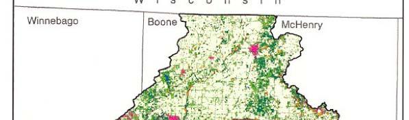

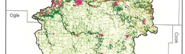
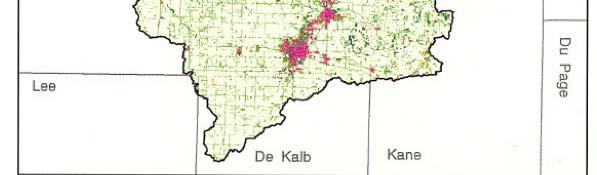

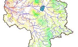
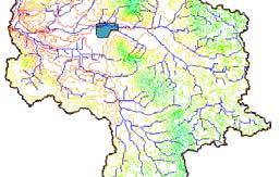
28 Urbanization and Wetlands Creation in the Kishwaukee Watershed


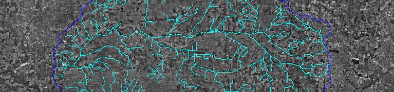


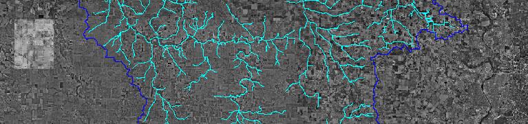
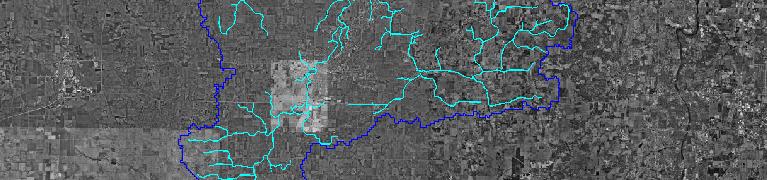
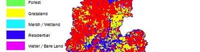
29 Watershed Overview Watershed Area: ~1100 mi 2 Fontana-on-Geneva Lake Stream Miles: ~1000 mi Overland flow Stream flow Infiltration Groundwater Tile Drains Detention Basin Wetland Hydraulics Rockford Rock River Belvidere Sycamore Woodstock Huntley Greater Chicago Area Fox River Geneva


30 Project Goals Develop Watershed Management Plan Placement of 1600 ac of wetlands Removal of tile drains Assess impacts of future land use


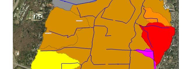
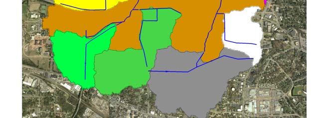
31 Impacts of Spatial Location: Wetlands Location Study
32 Wetlands Location Results Belvidere, Il Flo w (cms) No Wetlands Wetlands 1 Wetlands 2 Wetland 3 Wetland Time (min)


33 Spatial Hydrology: Dealing with Runoff Processes Changes Spatial effects of land use changes Where you put a commercial zone, detention basin, or wetland changes the hydrology Include engineered wetlands Include detention basins Planning and after the fact land use changes


34 Urbanization: Kishwaukee Watershed
35 Urbanization: Kishwaukee Watershed Results
36 Central Kishwaukee Flooding
37 Summary GSSHA is fully distributed, physics based watershed analysis and management tool. It can and has been used for a variety of analysis and engineering studies. The spatially explicit nature of the model allows user to directly incorporate important project features into the model. The physical basis allows parameter values to be logically adjusted d for changing conditions i land use, BMPs, climate conditions. The spatially explicit physics based approach offers advantages over simply models for analysis of conditions outside the range of calibration, changing, and inherently distributed processes such as sediment transport and non point source pollution.
38 New Orleans
Development and Application of Watershed Models for Simulation and Management of Nonpoint Source. Pollutants
 Development and Application of Watershed Models for Simulation and Management of Nonpoint Source Charles W. Downer Coastal and Hydraulic Laboratory Billy E. Johnson Environmental Laboratory Pollutants
Hydrologic Modeling Overview
 Hydrologic Modeling Overview Chuck Downer, PhD, PE Hydrologic Systems Branch Coastal and Hydraulics Laboratory Engineer Research and Development Center Vicksburg, Mississippi Hydrologic processes Hydrologic
Tools for Wetlands Permit Evaluation: Modeling Groundwater and Surface Water Interaction
 Tools for Wetlands Permit Evaluation: Modeling Groundwater and Surface Water Interaction Cary Talbot Coastal & Hydraulics Laboratory Example Wetland Permit Problem Applicant claimed proper drainage ditch
The Texas A&M University and U.S. Bureau of Reclamation Hydrologic Modeling Inventory (HMI) Questionnaire
 Questionnaire") The Texas A&M University and U.S. Bureau of Reclamation Hydrologic Modeling Inventory (HMI) Questionnaire May 4, 2010 Name of Model, Date, Version Number Dynamic Watershed Simulation Model (DWSM) 2002
The Texas A&M University and U.S. Bureau of Reclamation Hydrologic Modeling Inventory (HMI) Questionnaire May 4, 2010 Name of Model, Date, Version Number Dynamic Watershed Simulation Model (DWSM) 2002
Note that the Server provides ArcGIS9 applications with Spatial Analyst and 3D Analyst extensions and ArcHydro tools.
 Remote Software This document briefly presents the hydrological and hydraulic modeling software available on the University of Nice Server with Remote Desktop Connection. Note that the Server provides
Modeling Nutrient and Sediment Losses from Cropland D. J. Mulla Dept. Soil, Water, & Climate University of Minnesota
 Modeling Nutrient and Sediment Losses from Cropland D. J. Mulla Dept. Soil, Water, & Climate University of Minnesota Watershed Management Framework Identify the problems and their extent Monitor water
Training Course Brochure Building Capacity in Rural & Urban Water Management
 Training Course Brochure 2015 Building Capacity in Rural & Urban Water Management Introduction The WastePro Academy seeks to encourage the use of desktop software applications in the water and environmental
URBAN FLOODING: HEC-HMS
 1.0 Introduction URBAN FLOODING: HEC-HMS -Sunil Kumar, Director, NWA All major ancient civilisations were developed in the river valleys because river served as source of water, food, transportation and
Hypothetical Flood Computation for a Stream System
 US Army Corps of Engineers Hydrologic Engineering Center Hypothetical Flood Computation for a Stream System December 1968 Approved for Public Release. Distribution Unlimited. TP-12 REPORT DOCUMENTATION
Representing the Integrated Water Cycle in Community Earth System Model
 Representing the Integrated Water Cycle in Community Earth System Model Hong-Yi Li, L. Ruby Leung, Maoyi Huang, Nathalie Voisin, Teklu Tesfa, Mohamad Hejazi, and Lu Liu Pacific Northwest National Laboratory
A Study to Estimate Current and Future CSOs to Bubbly Creek and Identify Impacts on the Chicago Area Waterways (CAWS)
") A Study to Estimate Current and Future CSOs to Bubbly Creek and Identify Impacts on the Chicago Area Waterways (CAWS) IWEA WATERCON 2012 Springfield, Illinois March 19, 2012 presented by David Kiel, USACE
A Study to Estimate Current and Future CSOs to Bubbly Creek and Identify Impacts on the Chicago Area Waterways (CAWS) IWEA WATERCON 2012 Springfield, Illinois March 19, 2012 presented by David Kiel, USACE
Lecture 9A: Drainage Basins
 GEOG415 Lecture 9A: Drainage Basins 9-1 Drainage basin (watershed, catchment) -Drains surfacewater to a common outlet Drainage divide - how is it defined? Scale effects? - Represents a hydrologic cycle
Alternative Approaches to Water Resource System Simulation
 US Army Corps of Engineers Hydrologic Engineering Center Alternative Approaches to Water Resource System Simulation May 1972 Approved for Public Release. Distribution Unlimited. TP-32 REPORT DOCUMENTATION
Suspended Sediment Discharges in Streams
 US Army Corps of Engineers Hydrologic Engineering Center Suspended Sediment Discharges in Streams April 1969 Approved for Public Release. Distribution Unlimited. TP-19 REPORT DOCUMENTATION PAGE Form Approved
Hydrologic cycle, runoff process
 Hydrologic cycle, runoff process Motivation of hydrological modelling What happens at the catchment and in the stream when it rains? How does the increased/decreased runoff affect (not only) the landowners
Hydrology and Water Management. Dr. Mujahid Khan, UET Peshawar
 Hydrology and Water Management Dr. Mujahid Khan, UET Peshawar Course Outline Hydrologic Cycle and its Processes Water Balance Approach Estimation and Analysis of Precipitation Data Infiltration and Runoff
Petascale Hydrologic Modeling: Opportunities and Challenges. Fred L. Ogden Craig C. Douglas Scott N. Miller Ye Zhang
 Petascale Hydrologic Modeling: Opportunities and Challenges Fred L. Ogden Craig C. Douglas Scott N. Miller Ye Zhang CI-WATER Project NSF Cyberinfrastructure Cooperative Agreement joint between Utah and
APPENDIX IV. APPROVED METHODS FOR QUANTIFYING HYDROLOGIC CONDITIONS OF CONCERN (NORTH ORANGE COUNTY)
") APPENDIX IV. APPROVED METHODS FOR QUANTIFYING HYDROLOGIC CONDITIONS OF CONCERN (NORTH ORANGE COUNTY) Hydromodification design criteria for the North Orange County permit area are based on the 2- yr, 24-hr
APPENDIX IV. APPROVED METHODS FOR QUANTIFYING HYDROLOGIC CONDITIONS OF CONCERN (NORTH ORANGE COUNTY) Hydromodification design criteria for the North Orange County permit area are based on the 2- yr, 24-hr
Event and Continuous Hydrological Modeling with HEC- HMS: A Review Study
 Event and Continuous Hydrological Modeling with HEC- HMS: A Review Study Sonu Duhan *, Mohit Kumar # * M.E (Water Resources Engineering) Civil Engineering Student, PEC University Of Technology, Chandigarh,
WMS Tools For Computing Hydrologic Modeling Parameters
 WMS Tools For Computing Hydrologic Modeling Parameters Lesson 9 9-1 Objectives Use the drainage coverage as a basis for geometric parameters as well as overlaying coverages to compute important hydrologic
Salinity TMDL Development and Modeling in the Otter Creek Watershed. Erik Makus DEQ Hydrologist June 6, 2013
 Salinity TMDL Development and Modeling in the Otter Creek Watershed 1 Erik Makus DEQ Hydrologist June 6, 2013 Outline for Today: Otter Creek and the Tongue River Previous salinity modeling efforts Existing
2
 1 2 3 4 5 6 The program is designed for surface water hydrology simulation. It includes components for representing precipitation, evaporation, and snowmelt; the atmospheric conditions over a watershed.
RAINFALL-RUNOFF STUDY FOR SINGAPORE RIVER CATCHMENT
 10 th International Conference on Hydroinformatics HIC 2012, Hamburg, GERMANY RAINFALL-RUNOFF STUDY FOR SINGAPORE RIVER CATCHMENT CHI DUNG DOAN (1)(3), JIANDONG LIU (1), SHIE-YUI LIONG (1), ADRI VERWEY
Minnesota River Basin Interagency Study
 650 Minnesota River Basin Interagency Study Agencies collaborate for basin water quality and ecosystem restoration in Minnesota, Iowa, North Dakota, and South Dakota A multi-state effort is underway to
COUNTY OF KANE. Kishwaukee River Headwaters Study Stakeholder Meeting Monday, February 26, :30 am Hampshire Village Hall
 COUNTY OF KANE ENVIRONMENTAL AND BUILDING MANAGEMENT Timothy Harbaugh, P.E., DEE Director County Government Center 719 Batavia Avenue Geneva, IL 60134 www.co.kane.il.us Environmental Management: (630)
History of Model Development at Temple, Texas. J. R. Williams and J. G. Arnold
 History of Model Development at Temple, Texas J. R. Williams and J. G. Arnold INTRODUCTION Then Model development at Temple A long history (1937-present) Many scientists participating in: Data collection
Phase 1 Part 2 CSO Control Plan Wellington Avenue CSO Facility. Hydraulic Modeling Software Selection
 DRAFT Technical Memorandum Phase 1 Part 2 CSO Control Plan Wellington Avenue CSO Facility Hydraulic Modeling Software Selection Prepared for: City of Newport Public Works Department 70 Halsey Street Newport,
WATER RESOURCES MANAGEMENT Vol. II - Watershed Modeling For Water Resource Management - D. K. Borah WATERSHED MODELING FOR WATER RESOURCE MANAGEMENT
 WATERSHED MODELING FOR WATER RESOURCE MANAGEMENT D. K. Borah Borah Hydro-Environmental Modeling, Champaign, Illinois, USA Keywords: Agriculture, agrochemical, BMP, hydrology, long-term continuous model,
Comparison of Lumped and Distributed Hydrologic Models for the Runoff Simulation of a Large Watershed in Alabama and Mississippi
 Comparison of Lumped and Distributed Hydrologic Models for the Runoff Simulation of a Large Watershed in Alabama and Mississippi Jairo N. Diaz-Ramirez Billy E. Johnson William H. McAnally James L. Martin
Appendix 12. Pollutant Load Estimates and Reductions
 Appendix 12. Pollutant Load Estimates and Reductions A pollutant loading is a quantifiable amount of pollution that is being delivered to a water body. Pollutant load reductions can be calculated based
PANAMA CANAL RESERVOIR WATER QUALITY EVALUATION STUDY
 PANAMA CANAL RESERVOIR WATER QUALITY EVALUATION STUDY Billy E. Johnson, PhD, PE Research Civil Engineer Engineer Research and Development Center U.S. Army Corps of Engineers Vicksburg, MS. USA Barry W.
Coupled Hydrological and Thermal Modeling of Permafrost and Active Layer Dynamics: Implications to Permafrost Carbon Pool in Northern Eurasia
 Coupled Hydrological and Thermal Modeling of Permafrost and Active Layer Dynamics: Implications to Permafrost Carbon Pool in Northern Eurasia Sergey Marchenko & Vladimir Romanovsky University of Alaska
Re-plumbing Roadside Ditch Networks
 Re-plumbing Roadside Ditch Networks Ditches Improving management to reduce flooding, water pollution, and in-stream erosion and habitat degradation Rebecca Schneider Dept. Natural Resources Cornell University,
Municipal Stormwater Management Planning
 Municipal Stormwater Management Planning Christopher C. Obropta, Ph.D., P.E. Water Resources Extension Specialist with Rutgers Cooperative Extension Assistant Professor with Department of Environmental
Clean Water is Everyone s Business. A commercial & industrial property owner s guide to improving Lake Tahoe s clarity
 Clean Water is Everyone s Business A commercial & industrial property owner s guide to improving Lake Tahoe s clarity this informational guide will help you understand the tahoe regional planning agency
1 n. Flow direction Raster DEM. Spatial analyst slope DEM (%) slope DEM / 100 (actual slope) Flow accumulation
 slope DEM / 100 (actual slope) Flow accumulation") 1 v= R S n 2/3 1/2 DEM Flow direction Raster Spatial analyst slope DEM (%) Flow accumulation slope DEM / 100 (actual slope) 0 = no cell contributing 215 = 215 cell contributing towards that cell sqrt (actual
1 v= R S n 2/3 1/2 DEM Flow direction Raster Spatial analyst slope DEM (%) Flow accumulation slope DEM / 100 (actual slope) 0 = no cell contributing 215 = 215 cell contributing towards that cell sqrt (actual
BAEN 673 / February 18, 2016 Hydrologic Processes
 BAEN 673 / February 18, 2016 Hydrologic Processes Assignment: HW#7 Next class lecture in AEPM 104 Today s topics SWAT exercise #2 The SWAT model review paper Hydrologic processes The Hydrologic Processes
M.L. Kavvas, Z. Q. Chen, M. Anderson, L. Liang, N. Ohara Hydrologic Research Laboratory, Civil and Environmental Engineering, UC Davis
 Assessment of the Restoration Activities on Water Balance and Water Quality at Last Chance Creek Watershed Using Watershed Environmental Hydrology (WEHY) Model M.L. Kavvas, Z. Q. Chen, M. Anderson, L.
Overview of the Surface Hydrology of Hawai i Watersheds. Ali Fares Associate Professor of Hydrology NREM-CTAHR
 Overview of the Surface Hydrology of Hawai i Watersheds Ali Fares Associate Professor of Hydrology NREM-CTAHR 5/23/2008 Watershed Hydrology Lab 1 What is Hydrology? Hydrology is the water science that
Introduction. Welcome to the Belgium Study Abroad Program. Courses:
 Introduction Welcome to the Belgium Study Abroad Program Courses: AGSM 335: Soil and Water Management BAEN 460: Principals of Environmental Hydrology BAEN 460 / AGSM 335 Combined lecture and HW sessions
Hydrology 101. Impacts of the Urban Environment. Nokomis Knolls Pond Summer June 2008
 Hydrology 101 Nokomis Knolls Pond Summer 2002 Impacts of the Urban Environment Hydrologic Cycle; What is it? Geography, Topography, Geology, Land Cover and Climate determine the Amount and Behavior of
APPENDIX H Guidance for Preparing/Reviewing CEQA Initial Studies and Environmental Impact Reports
 APPENDIX H H.1 Guidance for Preparing and Reviewing CEQA Initial Studies Step 1: Consider the Project Characteristics as Provided by the Project Applicant Review the project application and draft plan
Stormwater Retention Pond Recovery Analysis
 Stormwater Retention Pond Recovery Analysis By Nicolas E Andreyev The first in a series of courses on Green Drainage Design www.suncam.com Page 1 of 33 Forward To design a stormwater retention pond, one
Texas A & M University and U.S. Bureau of Reclamation Hydrologic Modeling Inventory Model Description Form
 Texas A & M University and U.S. Bureau of Reclamation Hydrologic Modeling Inventory Model Description Form JUNE 18, 1999 Name of Model: MIKE 11 RR (Rainfall Runoff) Model Type: The MIKE 11 RR model is
Rainfall, runoff and sediment transport in the Napa River watershed: now and a possible future
 Rainfall, runoff and sediment transport in the Napa River watershed: now and a possible future Lester McKee San Francisco Estuary Institute 5/24/2017 1 The importance of the natural water cycle of infiltration
An Overview of JULES. Christina Bakopoulou
 An Overview of JULES Christina Bakopoulou JULES, MOSES AND TRIFFID JULES (Joint UK Land Environment Simulator) is a new land surface model Joint initiative: NERC through the CEH, CLASSIC, QUEST and the
ADVANCED APPLICATIONS OF HEC-HMS
 Hydrologic Engineering Center Training Course on ADVANCED APPLICATIONS OF HEC-HMS 18 22 April 2016 Davis, California Course Objectives The course covers a variety of areas that go beyond the Basic HEC-HMS
GIS Applications in Water Resources Engineering
 King Fahd University of Petroleum & Minerals City & Regional Planning Department Introduction to Geographic Information Systems Term Paper Presentation GIS Applications in Water Resources Engineering Prepared
Setting the Course for Improved Water Quality: Modeling for TMDL Studies
 Setting the Course for Improved Water Quality: Modeling for TMDL Studies A TMDL training program for local government leaders and other water managers Session 11a wq-iw3-61a Presentation goals Define the
Effect of Land Surface on Runoff Generation
 Effect of Land Surface on Runoff Generation Context: Hydrologic Cycle Runoff vs Infiltration Infiltration: Process by which water on the ground surface enters the soil Runoff: Water (from rain, snowmelt,
D. Common Water Quality Models
 D. Common Water Quality Models In this appendix we introduce a few of the common models used in water quality analysis. This is by no means a complete list, but does provide a starting point from which
M.L. Kavvas, Z. Q. Chen, M. Anderson, L. Liang, N. Ohara Hydrologic Research Laboratory, Civil and Environmental Engineering, UC Davis
 Assessment of the Restoration Activities on Water Balance and Water Quality at Last Chance Creek Watershed Using Watershed Environmental Hydrology (WEHY) Model M.L. Kavvas, Z. Q. Chen, M. Anderson, L.
Demonstration of GSSHA Hydrology and Sediment at Eau Galle Watershed Near Spring Valley, Wisconsin
 Demonstration of GSSHA Hydrology and Sediment at Eau Galle Watershed Near Spring Valley, Wisconsin by Charles W. Downer PURPOSE: The purpose of this System-Wide Water Resources Program (SWWRP) technical
LID PLANTER BOX MODELING
 LID PLANTER BOX MODELING Clear Creek Solutions, Inc., 2010 Low Impact Development (LID) planter boxes are small, urban stormwater mitigation facilities. They are rain gardens in a box. WWHM4 provides the
Mission. Selected Accomplishments from Walnut Gulch. Facilities. To develop knowledge and technology to conserve water and soil in semi-arid lands
 USDA-ARS Southwest Watershed Research Center Mission Sound Science for Watershed Decisions To develop knowledge and technology to conserve water and soil in semi-arid lands ARS Watershed Locations Selected
Assessment of Watershed Soundness by Water Balance Using SWAT Model for Han River Basin, South Korea
 2015 International SWAT Conference & Workshops October 12-16, 2015 Purdue University, USA SESSION A3: HYDROLOGY Room: Stewart 278 2015 International SWAT Conference Assessment of Watershed Soundness by
Nutrient Management in. A presentation to the West Metro Water Alliance
 Nutrient Management in Developing and Agricultural Areas A presentation to the West Metro Water Alliance Chris Meehan, P.E. May 25, 2011 Agenda Physical Improvements Planning Improvements How to get it
Constructed Wetland Pond T-8
 Constructed Wetland Pond T-8 Description A constructed wetlands pond is a shallow retention pond designed to permit the growth of wetland plants such as rushes, willows, and cattails. Constructed wetlands
CE Hydraulics. Andrew Kennedy 168 Fitzpatrick
 CE 40450 Hydraulics Andrew Kennedy 168 Fitzpatrick Andrew.kennedy@nd.edu Hydraulics What does hydraulics mean for engineers and what are typical hydraulic engineering problems? How do these interact with
L-THIA Online and LID in a watershed investigation
 L-THIA Online and LID in a watershed investigation Larry Theller Agricultural and Biological Engineering, Purdue University Great Lakes Sedimentation Workshop Ann Arbor Mi. L-THIA On-line watershed delineation
Advances in the modeling of Watershed and Riverine Fate and Transport of Contaminants
 Advances in the modeling of Watershed and Riverine Fate and Transport of s Mass Transfer Mass Transfer Deposition Resuspension Deposition Resuspension SWAT 2015 - Sardinia, Italy June 22-26, 2015 Air-Water
IAFSM 2010 Annual Conference. City of Rockford Keith Creek Greenway Flood Mitigation Project
 IAFSM 2010 Annual Conference City of Rockford Keith Creek Greenway Flood Mitigation Project March 10, 2010 Introduction Problem Overview 1890 s Building of homes along Keith Creek 1920 s Home construction
Hydrologic and Watershed Model Integration Tool (HydroWAMIT) and Its Application to North & South Branch Raritan River Basin
 and Its Application to North & South Branch Raritan River Basin") Hydrologic and Watershed Model Integration Tool (HydroWAMIT) and Its Application to North & South Branch Raritan River Basin Gopi K. Jaligama Omni Environmental LLC 321 Wall St. Princeton NJ 08540 Email:
Hydrologic and Watershed Model Integration Tool (HydroWAMIT) and Its Application to North & South Branch Raritan River Basin Gopi K. Jaligama Omni Environmental LLC 321 Wall St. Princeton NJ 08540 Email:
Unit 2: Weather Dynamics Chapter 1: Hydrological Cycle
 UNIT 2 Chapter 1: Inquiring about Weather Unit 2: Weather Dynamics Chapter 1: Hydrological Cycle Science 10 Mrs. Purba Importance of H 2 O From the beginning of time when water first appeared, it has been
Initial Application of a Landscape Evolution Model to a Louisiana Wetland
 Initial Application of a Landscape Evolution Model to a Louisiana Wetland by Carl F. Cerco PURPOSE: Corps planning projects encompass a wide variety of restoration goals. These include wetland restoration,
Overview of NRCS (SCS) TR-20 By Dr. R.M. Ragan
 TR-20 By Dr. R.M. Ragan") Overview of NRCS (SCS) TR-20 By Dr. R.M. Ragan TR-20 is a computer program for the simulation of runoff occurring from a single storm event. The program develops flood hydrographs from runoff and routes
Overview of NRCS (SCS) TR-20 By Dr. R.M. Ragan TR-20 is a computer program for the simulation of runoff occurring from a single storm event. The program develops flood hydrographs from runoff and routes
Tools to Improve Water Quality
 Tools to Improve Water Quality SARA Water Quality Modeling Tool Development Client: San Antonio River Authority (SARA) Firm: Lockwood, Andrews & Newnam, Inc. Category A: Studies, Research and Consulting
CEE6400 Physical Hydrology
 CEE6400 Physical Hydrology Midterm Review Learning Objectives (what you should be able to do) Hydrologic data, the hydrologic cycle and water balance (HW 1) Work with hydrologic data, quantify uncertainty
Chapter IV: SUMMARY OF MODEL DEVELOPMENT AND RESULTS. The quantity of runoff, precipitation, evaporation,
 Chapter IV: CONCLUSIONS SUMMARY OF MODEL DEVELOPMENT AND RESULTS The quantity of runoff, precipitation, evaporation, evapotranspiration, diversions, and storage changes in the Mono Basin and their annual
Watershed - Lake Model to Support TMDL Determinations for Lake Thunderbird
 Watershed - Lake Model to Support TMDL Determinations for Lake Thunderbird 18 th Annual EPA Region 6 Stormwater Conference Workshop 5: TMDLs and You October 3, 2016 Oklahoma City, OK Lake Thunderbird Watershed-Lake
Modeling catchment scale infiltration
 Modeling catchment scale infiltration Serena Ceola, DICAM, University of Bologna Advanced Hydrology & Water Resources Management INTRODUCTION OBJECTIVE: Understanding the processes and the methods for
Index. Page numbers followed by f indicate figures.
 Index Aerodynamic method, 103, 110 111 Algae, 131, 173, 175 Alternate depth, 88 Alternating block method, 132, 140 141 Attenuation, 106, 107f, 118, 120 Page numbers followed by f indicate figures. Baseflow
Environmental Management at DoD Facilities in the Chesapeake Bay Region. US Army Corps of Engineers BUILDING STRONG
 Environmental Management at DoD Facilities in the Chesapeake Bay Region Sharon Madden U.S. Corps of Engineers Baltimore District NCER US Army Corps of Engineers Baltimore District Military Support Provides
Use of SWAT for Urban Water Management Projects in Texas
 Use of SWAT for Urban Water Management Projects in Texas Jaehak Jeong and Allan Jones Texas AgriLife Research Presentation Outline Modeling of Urban Watersheds and Stormwater Best Management Practices
Application of SWAT Model in land-use. change in the Nile River Basin: A Review
 Application of SWAT Model in land-use change in the Nile River Basin: A Review By: Marwa Ali, Okke Batelaan and Willy Bauwens 15-6-2011 Application of SWAT Model in land-use 1 change in the Nile River
Chapter 1. Introduction
 Chapter 1 Introduction James P. Heaney, Robert Pitt, and Richard Field Introduction Stormwater has traditionally been considered a nuisance, requiring rapid and complete drainage from areas of habitation.
5. Water Budget Implementation Procedures
 5. Water Budget Implementation Procedures 5.1 General The purpose of the watershed level water budget is to determine the volume of surface and groundwater available for the benefit of both human populations
INFLOW DESIGN FLOOD CONTROL SYSTEM PLAN 40 C.F.R. PART PLANT YATES ASH POND 3 (AP-3) GEORGIA POWER COMPANY
 GEORGIA POWER COMPANY") INFLOW DESIGN FLOOD CONTROL SYSTEM PLAN 40 C.F.R. PART 257.82 PLANT YATES ASH POND 3 (AP-3) GEORGIA POWER COMPANY EPA s Disposal of Coal Combustion Residuals from Electric Utilities Final Rule (40 C.F.R.
INFLOW DESIGN FLOOD CONTROL SYSTEM PLAN 40 C.F.R. PART 257.82 PLANT YATES ASH POND 3 (AP-3) GEORGIA POWER COMPANY EPA s Disposal of Coal Combustion Residuals from Electric Utilities Final Rule (40 C.F.R.
Hydrologic Engineering Center. Training Course on. Hydrologic Modeling with HEC-HMS. Davis, CA. Course Description
 Hydrologic Engineering Center Training Course on Hydrologic Modeling with HEC-HMS Davis, CA Course Description The course provides an introduction to HEC-HMS for new users, focusing both on using the program
MODULE 1 RUNOFF HYDROGRAPHS WORKSHEET 1. Precipitation
 Watershed MODULE 1 RUNOFF HYDROGRAPHS WORKSHEET 1 A watershed is an area of land thaaptures rainfall and other precipitation and funnels it to a lake or stream or wetland. The area within the watershed
By Richard Smardon PhD Professor of Environmental Studies, SUNY/ESF
 TREATMENT WETLAND RESEARCH & IMPLEMENTATION IN CENTRAL NEW YORK as part of Wetlands, Watersheds and Resources Technical Assistance partnership Forum Thursday March 22, 2012 Center of Excellence By Richard
Rainfall Runoff Modeling using MIKE 11 Nam A Review
 Rainfall Runoff Modeling using MIKE 11 Nam A Review Neerav Agrawal 1 and T.S. Desmukh 2 1 M.Tech Student, Department of Civil Engineering, M.A.N.I.T., Bhopal, M.P. India 2 Professor, Department of Civil
Peak discharge computation
 Ia/P 4 Peak Dischage Method Graphical Peak Discharge Method This chapter presents the Graphical Peak Discharge method for computing peak discharge from rural and urban areas. The Graphical method was developed
Methods of Streamflow Analysis
 4 Methods of Streamflow Analysis CHAPTER 4 Streamflow Measurements Danielle M. Andrews Department of Crop and Soil Sciences, The Pennsylvania State University I. INTRODUCTION Perennial carries water all
Hydrologic Engineering Center. Training Course on. Hydrologic Modeling with HEC-HMS April 2018 Davis, CA. Course Description
 Hydrologic Engineering Center Training Course on Hydrologic Modeling with HEC-HMS 23-27 April 2018 Davis, CA Course Description The course provides an introduction to HEC-HMS for new users, focusing both
Event and Continuous Hydrologic Modeling with HEC-HMS
 Event and Continuous Hydrologic Modeling with HEC-HMS Xuefeng Chu, A.M.ASCE 1 ; and Alan Steinman 2 Abstract: Event hydrologic modeling reveals how a basin responds to an individual rainfall event e.g.,
San Antonio Water System Mitchell Lake Constructed Wetlands Below the Dam Preliminary Hydrologic Analysis
 San Antonio Water System enhancement. This recommendation was based on limited water quality data provided by SAWS and using a free-water surface constructed wetland with approximately 112 acres of wetted
HYDROLOGIC MODELING CONSISTENCY AND SENSITIVITY TO WATERSHED SIZE
 HYDROLOGIC MODELING CONSISTENCY AND SENSITIVITY TO WATERSHED SIZE by James C.Y. Guo. Professor, Civil Engineering, U. Of Colorado at Denver, James.Guo@cudenver.edu.. And Eric Hsu, Project Engineer, Parson
A Case for the Design and Modeling of BMP Infiltration and LID Techniques. By: Bob Murdock
 A Case for the Design and Modeling of BMP Infiltration and LID Techniques 2009 IAFSM Annual Conference 2009 IAFSM Annual Conference By: Bob Murdock Presentation Outline 1. Runoff Reduction (RR) and Low
The Effect of Surface Texture on Evaporation, Infiltration and Storage Properties of Paved Surfaces
 The Effect of Surface Texture on Evaporation, Infiltration and Storage Properties of Paved Surfaces M. Mansell* and F. Rollet School of Engineering and Science, University of the West of Scotland, Paisley
Model objectives. Main features. Water Evaluation And Planning (WEAP)
") Water Evaluation And Planning (WEAP) Model objectives WEAP ( Water Evaluation And Planning system) is a userfriendly software tool that fully integrates water supply, demand, water quality and ecological
Water Evaluation And Planning (WEAP) Model objectives WEAP ( Water Evaluation And Planning system) is a userfriendly software tool that fully integrates water supply, demand, water quality and ecological
Water Resources on PEI: an overview and brief discussion of challenges
 Water Resources on PEI: an overview and brief discussion of challenges Components: Components and links Atmospheric water Surface water (including glacial water) Groundwater Links: Precipitation (atm(
Crow s Foot Conservation Area Feasibility Study
 Crow s Foot Conservation Area Feasibility Study Site Opportunities Presentation Trust For Public Land PRESENTED BY SmithGroup JJR August, 2002 McHenry County Conservation District Boone County Conservation
Headwater Wetland Restoration Techniques The Wetland Drain Restoration Project
 Headwater Wetland Restoration Techniques The Wetland Drain Restoration Project Tools for Managing Small Drainage Features in Rural Landscapes Workshop, March 5, 2014 Dave Richards, Partnership Specialist,
SURFACE WATER HYDROLOGY AND HYDRAULICS SECTION
 SURFACE WATER HYDROLOGY AND HYDRAULICS SECTION The mission of the Surface Water Hydrology and Hydraulics section is to generate historical and spatial scientific data, investigate and understand watershed
Applying HSPF in Cooper River Watershed for Watershed Restoration Planning
 Applying HSPF in Cooper River Watershed for Watershed Restoration Planning Zeyuan Qiu New Jersey Institute of Technology September 20, 2007 Outline Why watershed modeling Why HSPF in Cooper River Watershed
MODELING WATER FLOW AND CONTAMINANT TRANSPORT IN SOILS AND GROUNDWATER USING THE HYDRUS COMPUTER SOFTWARE PACKAGES
 MODELING WATER FLOW AND CONTAMINANT TRANSPORT IN SOILS AND GROUNDWATER USING THE HYDRUS COMPUTER SOFTWARE PACKAGES Instructor Dr. Jirka Simunek Department of Environmental Sciences University of California
Standards for Soil Erosion and Sediment Control in New Jersey May 2012 STANDARD FOR GRASSED WATERWAYS. Definition. Purpose
 STANDARD FOR GRASSED WATERWAYS Definition A natural or constructed watercourse shaped or graded in earth materials and stabilized with suitable vegetation for the safe conveyance of runoff water. Purpose
Hydrologic Study Report for Single Lot Detention Basin Analysis
 Hydrologic Study Report for Single Lot Detention Basin Analysis Prepared for: City of Vista, California August 18, 2006 Tory R. Walker, R.C.E. 45005 President W.O. 116-01 01/23/2007 Table of Contents Page