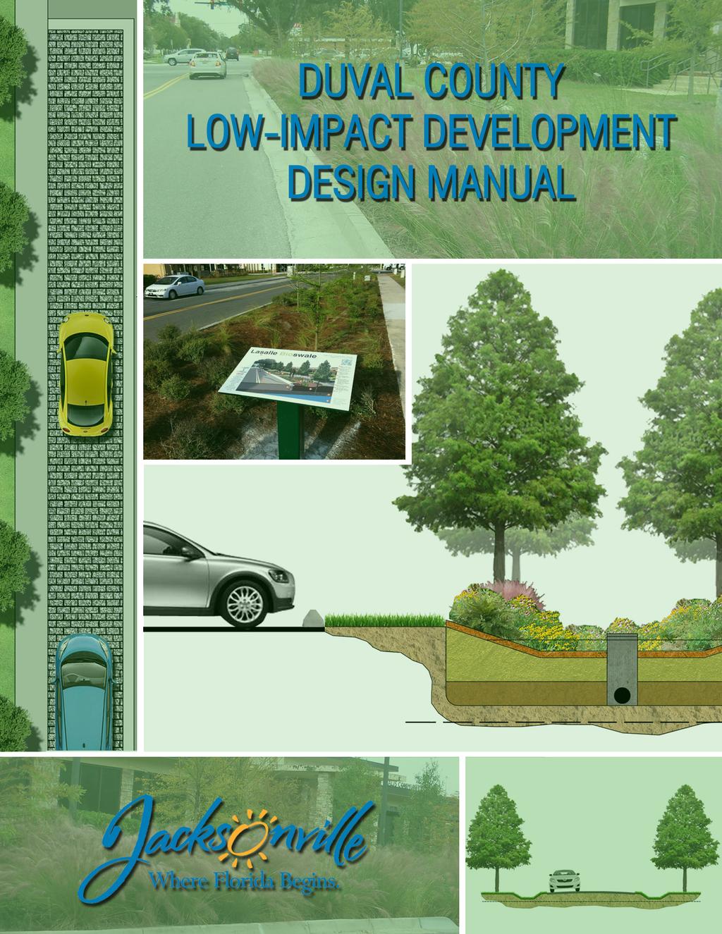
DUVAL COUNTY LOW-IMPACT DEVELOPMENT MANUAL. Prepared for: CITY OF JACKSONVILLE. Ed Ball Building. 214 North Hogan Street, Suite 600
|
|
|
- Kerry Summers
- 6 years ago
- Views:
Transcription
1
2 DUVAL COUNTY LOW-IMPACT DEVELOPMENT MANUAL Prepared for: CITY OF JACKSONVILLE Ed Ball Building 214 North Hogan Street, Suite 600 Jacksonville, Florida Prepared by: JONES EDMUNDS & ASSOCIATES, INC. 730 NE Waldo Road Gainesville, Florida July 2013
3 IF A HARDCOPY OF THIS DOCUMENT IS NEEDED, PLEASE TRY TO SAVE PAPER AND PRINT THIS DOCUMENT DOUBLE-SIDED. This manual is available for download from the following website: ACKNOWLEDGEMENT Significant portions of the Duval County LID Manual are based on the following: Preliminary Sarasota County LID Manual (March 2012 Working Copy) Florida Department of Environmental Protection and Water Management Districts Environmental Resource Permit Stormwater Quality Applicant's Handbook (March 2010 Draft). St. Johns River Water Management District Applicants Handbook (December 2010) DISCLAIMER While many developments share common elements, each is unique. The information in this manual is intended only as a starting point and guidance for the reader and should be used only with careful consideration of applicable laws, rules, codes, ordinances, standards, and the like, including without limitation the Americans with Disabilities Act and interpretations of laws in effect at the time of a specific development. This manual does not change in any way the laws applicable to planning, designing, constructing, operating, and maintaining building and development projects in Duval County, Florida. The authors have made a good-faith effort to provide timely and correct information. However, some inaccuracies may occur due to, for example, a change in applicable laws since publication. For this reason, the authors cannot and do not represent or warrant the completeness or accuracy of the information. The information is supplied on the condition that the reader will make his or her determination as to its suitability for his or her purposes. The responsibility for using a standard in this manual remains with the professional or other person responsible for planning, designing, constructing, operating, and maintaining a specific project. The use of brand names in this publication does not indicate an endorsement by the authors, the City of Jacksonville, or the State of Florida.
4 TABLE OF CONTENTS 1 MANUAL OVERVIEW Purpose of Manual Background Design Goal Intended Users Organization of Manual Chapter 2: Evaluating Your Site and Planning for LID Chapter 3: LID Practices for Duval County Demonstrating LID Effectiveness Water Quality Water Quantity Local Context Duval County s Hydrology Urbanization and Water Quality Standards Standards Supporting LID Terminology References Appendices EVALUATING YOUR SITE AND PLANNING FOR LID Overview Site Assessment Defining Project Intent Evaluating Predevelopment Conditions Site planning and design Preserving Site Assets Minimizing and Controlling Runoff Generation at the Source Promoting Infiltration Promoting Stormwater Harvesting Minimizing Site Disturbance Performance Monitoring and Feedback Mechanisms Project Guidance for Design Professionals References LID PRACTICES IN DUVAL COUNTY Grassed Conveyance Swales September 2013 i Table of C
5 3.1.1 General Design Considerations and Requirements Design Procedure Construction Operation and Maintenance References Shallow Bioretention General Design Considerations and Requirements Design Procedure Operation and Maintenance References Pervious Pavements General Design Considerations and Requirements Example Pervious Pavement Design Procedure Construction Operation and Maintenance References September 2013 ii Table of C
6 LIST OF TABLES Table Performance Reduction Factors for Average Annual Percolation Volume for Grassed Conveyance Swales in Duval County for SHWL between 24-inch and 6-inch of the Swale Bottom Table Average Annual Concentration Reduction in a Grassed Conveyance Swale LIST OF FIGURES Figure 1-1 Treatment Train Effectiveness for a Dry Treatment System Followed by a Wet Treatment System... 4 Figure 1-2 Hydrologic Soil Groups... 6 Figure Land Use... 7 Figure Cross-Section View of a Grassed Swale System Figure Plan and Cross-Section Views Illustrating a Shallow Bioretention System Figure Average Annual Runoff Capture Efficiency for a Bioretention System in City of Jacksonville Figure Common Pervious Pavement Materials: a) Permeable Interlocking Concrete Pavers, (b) Porous Concrete, (c) Flexi-pave TM Figure Typical Pervious Pavement System Figure Examples of Pervious Pavement (a: Driveway, b: Walking Path, c: Parking Lane) Figure Long-Term Runoff Capture Based on Depth to Pre-Development Seasonal High Water Level and Pervious Pavement System Storage APPENDICES APPENDIX A APPENDIX B APPENDIX C APPENDIX D APPENDIX E APPENDIX F LID SITE-PLANNING AND EVALUATION GUIDANCE CHART RAINFALL AND RUNOFF DATA GRASSED CONVEYANCE SWALE DESIGN INFORMATION MEAN ANNUAL MASS REMOVAL EFFICIENCIES FOR VARIOUS RETENTION DEPTHS IN ZONE 4 EVENT MEAN CONCENTRATIONS CITY OF JACKSONVILLE NPDES PERMIT INSPECTION AND MAINTENACE SCHEDULE FOR STRUCTURAL CONTROLS AND ROADWAYS September 2013 iii Table of C
7 FOREWORD The St. Johns River is Duval County s greatest natural resource. The river plays an important part in the region s history as well as its economic and recreational livelihood. However, the river has suffered from excessive nutrient loading from wastewater and stormwater discharges and has been deemed impaired by the Florida Department of Environmental Protection. A Lower St. Johns River Nutrient Basin Management Actin Plan (BMAP) issued by FDEP Secretarial Order in October 2008 requires specific nutrient-loading reductions for all entities discharging to the river. The Duval County Low-Impact Development Manual is intended to be used as a stormwater management tool for municipalities to meet BMAP obligations and for developers to have alternatives that meet local design specifications that also comply with Environmental Resource Permit requirements. The manual is based on the Preliminary Sarasota County Low-Impact Development Manual and its strategies. Although State and local environmental regulations of Duval and Sarasota Counties are similar, climate, soils, and plant hardiness zones differ. Therefore, different parameters are required in Low-Impact Development design practices. September 2013 iv Foreword
8 1 MANUAL OVERVIEW 1.1 PURPOSE OF MANUAL This manual provides technical guidance and design specifications on Low-Impact Development (LID) stormwater management practices to apply to projects in Duval County, Florida. This manual is not to be used in place of but rather as a supplement to the stormwater and surface water management guidance documents of the City of Jacksonville, St. Johns River Water Management District (SJRWMD), and other municipalities within Duval County with regard to local design criteria and LID applicability. The guidance provided in the manual is designed to be flexible, with performance criteria provided where possible. The first version of this manual is limited to detailed design information for three practices that were selected as being the most applicable for right-of-way in Duval County but may also be used in other stormwater management scenarios. Additional practices will be added to the manual as the need arises. Depending on the magnitude of specific or cumulative impacts, other methods of meeting the overall water resources objectives of the City of Jacksonville and SJRWMD may be considered. For all projects, check with local officials and other agencies to determine additional restrictions and/or surface water or watershed requirements that may apply. LID stormwater management practices are not mandatory in Duval County. However, Duval County encourages the use of LID practices where possible to help meet its water resource objectives. This manual is expected to be adopted by the City of Jacksonville Subdivision Standards and Policy Advisory Committee (SSPAC) and to be incorporated by reference as an attachment to the City of Jacksonville s Land Development Procedures Manual. 1.2 BACKGROUND LID is a stormwater management strategy that uses a suite of structural and non-structural hydrologic controls distributed throughout the site and integrated as a treatment train (i.e., in series to replicate the natural hydrologic functioning of the landscape). Unlike conventional systems that typically control and treat runoff using a single engineered stormwater pond at the bottom of the hill or the lowest point of an area, LID systems are designed to promote volume attenuation and treatment at or near the source of stormwater runoff via distributed retention, detention, infiltration, treatment, and harvesting mechanisms. The fundamental goal of applying LID concepts, designs, and practices is to improve the overall effectiveness and efficiency of stormwater management relative to conventional systems and thus reducing total and peak runoff volumes and improving the quality of waters discharged from the site. A site-specific suite of LID-integrated management practices can be applied to most if not all development scenarios in Duval County. Regardless of the project context, LID requires the following core siteplanning and design objectives to be considered: 1. Preserve or conserve existing site features and assets that facilitate natural hydrologic function. 2. Minimize runoff generated from impervious surfaces (i.e., use peak and total volume controls) and contamination (i.e., use load controls) as close to the source as possible. 3. Promote the distribution of retention, detention, treatment, and infiltration of runoff. 4. Harvest stormwater on site. 5. Minimize site disturbance and soil compaction through low-impact clearing, grading, and construction measures. The toolbox of LID-integrated management practices, including structural and non-structural designs, is most effective when applied in a treatment train, or a series of complementary stormwater management September Manual Ov
9 practices and techniques. Typically, LID practices will not completely replace other more conventional bottom-of-the-hill stormwater management practices but can be used to complement these practices and to ensure that the entire stormwater management system meets Duval County and SJRWMD water resources objectives. In addition, stormwater management that includes LID is most effective when sites are evaluated for LID compatibility as early as possible in the planning process and site conditions are considered carefully in the design and construction of each LID practice. This manual supports Duval County s goal of applying the LID concept and design where feasible to enhance existing stormwater management measures and reduce the adverse impacts of land development projects on the County s natural resources. 1.3 DESIGN GOAL The applicant must provide reasonable assurance that the use of LID will not: Cause adverse water quantity impacts to receiving waters. Cause flooding to on-site or off-site property. Cause adverse impacts to existing surface water storage and conveyance capabilities. Adversely impact the maintenance of surface water or groundwater levels or surface water flows. New development should be designed to comply with the stormwater quality and quantity requirements outlined in: The City of Jacksonville Land Development Procedures Manual. The City of Jacksonville 2030 Comprehensive Plan Infrastructure Element, Drainage Sub- Elements A and B. The City of Jacksonville Master Stormwater Plan. Stormwater treatment systems should be designed to combine best management practices (BMPs) structural and non-structural in a series to achieve the water quality and quantity goals. Refer to Chapter 3 for permitting guidance and example design calculations that meet Environmental Resource Permit (ERP) and City of Jacksonville criteria. Design criteria in the SJRWMD ERP Applicants Handbook Volume II are intended to be flexible; however, other BMPs may be permitted under non-presumptive criteria. Applicants proposing non-presumptive stormwater treatment BMPs, including alternative LID practices, must provide reasonable assurance that State water quality standards will be met based on information specific to the proposed design. Reasonable assurance under non-presumptive criteria involves demonstrating an annual pollutant-load reduction of 80% with 95% for direct discharges to an Outstanding Florida Water (OFW). 1.4 INTENDED USERS This LID Manual is intended to be used primarily by professionals engaged in planning, designing, constructing, operating, and maintaining building and development projects in Duval County. These potential users include but are not limited to stormwater design engineers, stormwater utility staff, natural resource managers, planning officials and administrators, building officials, architects, landscape architects, site design specialists, and landscape operations and maintenance professionals. September Manual Ov
10 1.5 ORGANIZATION OF MANUAL In addition to this chapter, which provides an overview of LID concepts and principles and an introduction to the context for applying LID practices in Duval County, this manual contains two additional chapters and four appendices to provide guidance on the planning, design, construction, operations, and maintenance of LID projects CHAPTER 2: EVALUATING YOUR SITE AND PLANNING FOR LID Chapter 2 focuses on the processes of site assessment, planning, and design for compatibility with LID principles and discusses mechanisms for integrating performance monitoring and feedback mechanisms at various stages of the development process. To ensure consistency with existing City of Jacksonville land development and stormwater management rules and requirements, Chapter 2 directs users of this manual to these guidance documents by reference CHAPTER 3: LID PRACTICES FOR DUVAL COUNTY City-specific technical guidance on the design, construction, operations, and maintenance specifications for the following LID-integrated management practices are detailed in Chapter 3: Grassed Conveyance Swales (Section 3.1). Shallow Bioretention (Section 3.2). Pervious Pavements (Section 3.3). Each section in Chapter 3 begins with an overview table that highlights the most critical information for the specific LID practice covered in that section. These overview tables provide the following: Key Considerations, including intent, most suitable applications, design criteria, advantages/benefits, disadvantages/limitations, and maintenance requirements. Pollutant-Removal Potential for total suspended solids, nutrients, metals, and pathogens, specified as High, Medium, or Low relative to other LID practices or No Data. Stormwater Management Suitability for addressing water quality and volume attenuation criteria. Implementation Considerations, including land requirement, capital cost, and maintenance burden, specified as High, Medium, or Low relative to other LID practices; residential subdivision suitability; high-density/ultra-urban suitability; drainage area requirement; shallow water table considerations; and soils criteria. Other Considerations critical for appropriately planning, designing, constructing, installing, operating, and maintaining the LID practice or system. Criteria in Chapter 3 are considered minimum standards for designing LID treatment systems in Duval County. Additional items are provided in case the applicant wants to enhance the water quality efficiency of the LID technique. Any single LID practice is unlikely to meet SJRWMD and City of Jacksonville water resource objectives; these practices are intended to be implemented in series with other LID practices and more traditional stormwater treatment practices a treatment-train approach. The stormwater treatment system (the treatment train) should be designed so that the entire system meets minimum stormwater control requirements. Users of this manual must consult with SJRWMD ERP criteria and the City of Jacksonville s guidance documents on land development and stormwater management, including September Manual Ov
11 the City Comprehensive Plan, Land Development Regulations, and Zoning Code for any variations from these criteria or additional standards that must be followed. 1.6 DEMONSTRATING LID EFFECTIVENESS Demonstrating the effectiveness of a stormwater treatment system will be a critical step in permitting a development in Duval County. This manual provides guidelines for demonstrating the effectiveness of LID practices for meeting the appropriate water quantity and water quality requirements and standards WATER QUALITY The water quality effectiveness of a stormwater treatment system that includes LID practices must be quantified based on the reduction in the average annual pollutant load. Chapter 3 provides details such as design curves that can be used to calculate the average annual load reduction of some LID practices in Duval County. The effectiveness of the entire stormwater treatment system must be calculated by first calculating the effectiveness of each practice and then determining the effectiveness of the entire system. Figure 1-1 shows an example of how this effectiveness can be demonstrated for Total Nitrogen (TN). The same approach can be used for other constituents. Figure 1-1 Treatment Train Effectiveness for a Dry Treatment System Followed by a Wet Treatment System Conveyance Detention Pond Swales Effectiveness TN =100lb Conveyance Swale 64% effective TN=36lb Detention Pond 30% effective TN=25lb TN = 64lb TN=11lb See Section for an example of how this would be calculated for a grassed conveyance swale WATER QUANTITY Most LID practices will provide some attenuation of peak flows and/or reduction in runoff volume during flood events. The effectiveness of some LID practice in reducing peak runoff rate and/or runoff volume can be demonstrated by modifying the Natural Resource Conservation Service (NRCS) Curve Number (CN) used to represent the LID practice and/or the area contributing to the practice. Chapter 3 provides details on how the CN should be modified. In some instances, the hydraulic functioning of the LID practice may be explicitly modeled. 1.7 LOCAL CONTEXT DUVAL COUNTY S HYDROLOGY LID applications should be designed to mimic the natural hydrologic functioning of a site. Five hydrologic soil groups, as classified by NRCS, are found in Duval County: A (well-drained), B/D (moderately welldrained when dry; not well-drained when wet), C (somewhat poorly drained), C/D (somewhat poorly drained when dry; not well-drained when wet), and D (poorly drained). Figure 1-2 maps these hydrologic September Manual Ov
12 soil groups in Duval County. Most soils in Duval County are classified in the B/D hydrologic soil group due to a shallow seasonal high water level (SHWL), so the performance of infiltration-dependent LID applications will be constrained under wet conditions in areas with these soil types. Land use varies widely throughout the County, with most development having occurred near the St. Johns River. Pine flatwoods dominate the west half of Duval County, while saltmarsh dominates the north portion. Figure 1-3 maps land use according to the SJRWMD 2009 land use, and Figure 1-4 maps the 9 major drainage basins in Duval County URBANIZATION AND WATER QUALITY STANDARDS Florida s stormwater rules established goals to control and treat runoff from urban development. Structural engineering criteria for stormwater ponds were designed to (1) minimize flooding and subsequent damage to property and life by providing adequate drainage and flood control and (2) achieve at least 85% average annual reductions in post-development pollutant loading. While these stormwater rules and design criteria have been effective in addressing flood control and have facilitated an efficient process for managing stormwater runoff, research indicates that they have fallen short of achieving established water quality goals (Harper and Baker, 2007). Over 200 of Florida s water bodies have been listed as impaired, meaning that they fail to achieve water quality standards established to maintain their designated use (e.g., potable water, shellfish propagation, recreation); nutrients in stormwater runoff particularly nitrogen and phosphorus have been identified as the cause of impairment in a majority of these water bodies (Florida Department of Environmental Protection, 2006b) STANDARDS SUPPORTING LID Although they may not use the term Low-Impact Development explicitly, many City of Jacksonville s ordinances, resolutions, and policies and SJRWMD s rules support the application of LID principles and design. City of Jacksonville documents that should be referenced with this manual to provide guidance on LID projects and to ensure compliance with requirements include but are not limited to the following: The City of Jacksonville 2030 Comprehensive Plan Transportation Element Recreation and Open Space Element Conservation Coastal Management Element Future Land Use Element Infrastructure Element Intergovernmental Coordination Element City of Jacksonville s Ordinance Code Environmental Affairs Code (Title X) Public Works and Utilities (Title XXI) September Manual Ov
13 Figure 1-2 Hydrologic Soil Groups Manual Ov September
14 Figure Land Use Manual Ov September


15 Figure 1-4 Major Drainage Basins C:\Documents and Settings\Lukacov\Desktop\LID Manual Final\ \DuvalCty_LID_Manual_Final Revised docx September Manual Ov
16 City of Jacksonville Land Development Procedures Manual City of Jacksonville Zoning Regulations (Title XVII Section 656, City of Jacksonville Ordinance Code) Regional watershed planning, floodplain protection, uplands preservation, wetlands protection, stream/watercourse protection buffers, riparian area and habitat protection, tree canopy protection, density and clustering provisions, street-width requirements, and curb-and-gutter requirements are among the key land use, development, and natural resource management issues that must be considered when planning for LID a process that is discussed in Chapter TERMINOLOGY This section defines terminology used throughout this manual. Average Annual Load Reduction: An estimate of the long-term average reduction in annual pollutant loading provided by a stormwater management practice. This is typically expressed as a percentage. Average Annual Rainfall: The long-term average rainfall that occurs annually (see Figure B-1 in Appendix B). Bioretention: The use of shallow landscaped depressions with soils, mulch, and planted vegetation intended to prevent the discharge of a given volume of stormwater runoff into surface waters by providing complete on-site storage. Cistern: A closed reservoir or tank used for storing stormwater for stormwater harvesting. Density: The number of residential dwelling units permitted per gross acre of land as determined by the City of Jacksonville s 2030 Comprehensive Plan: Future Land Use Element. Detention: The collection and temporary storage of stormwater with subsequent gradual release of the stormwater. Detention with Biofiltration: A landscaped depression area with a separate inlet and outlet (underdrain). Depressions are often linear and may be connected in series. Storage volume recovery of the depression is through an underdrain system. Other terms often applied to similar practices include biodetention, bioswales, and vegetated swale. Development: Any proposed material change in the use or character of the land, including but not limited to land-clearing associated with new construction, the placement of any structure or site improvement on the land, or expansion of existing buildings (Jacksonville, Florida, Ordinance Code, Zoning Section, Chapter 656-Zoning Code, Part 12 Landscape and Tree Protection Regulations). Diameter at Breast Height (DBH): The diameter of a plant s trunk or main stem 4.5 feet above the ground. Directly Connected Impervious Area (DCIA): The area covered by a building, impermeable pavement, and/or other impervious surfaces that drains directly into the conveyance without first flowing across sufficient permeable vegetated land area to allow for runoff infiltration. Equivalent Impervious Area (EIA): The area of a completely impervious watershed that would produce the same volume of runoff as the actual watershed. September Manual Ov
17 Floodplain: Land area subject to inundation by flood waters from a river, watercourse, or lake. Floodplains are delineated according to their estimated frequency of flooding. Low-Impact Development: A stormwater management approach that uses a suite of structural and non-structural hydrologic controls distributed throughout the site and integrated as a treatment train (i.e., in series) to replicate the natural hydrologic functioning of the landscape. Native: A species whose natural range included Florida at the time of European contact (1500 AD). Nutrient-Sorption Layer: A layer included in pervious pavement systems that absorbs nutrients, thereby reducing the nutrient loading from the system. Pervious Pavement: A pavement system that allows stormwater to infiltrate the parent soil. Predevelopment: The natural vegetative community type of the project area. Pretreatment: Stormwater volume and/or water quality controls applied upstream from or before capture, storage, treatment, infiltration, and/or harvesting by a subsequent stormwater management practice in a treatment train. Protected Tree: includes all of the following: Private protected tree means any tree with a DBH of 6 inches or more located on any lot within 20 feet of a street right-of-way (including an approved private street or other access easement) or a tree with a DBH of 8 inches or more located within 10 feet of any other property line, or a tree with a DBH of 11.5 inches or more located elsewhere on the lot. Public protected tree means any tree located on lands owned by the City of Jacksonville or other governmental agencies or authorities, or any land upon which easements are imposed for the benefit of the City of Jacksonville or other governmental agencies or authorities, or upon which other ownership control may be exerted by the City of Jacksonville or other governmental agencies or authorities, including rights-of-way, parks, public areas, and easements for drainage, sewer, water, and other public utilities, with: A DBH of 6 inches or more located within a County, City, or other governmental right-of-way, or A DBH of 6 inches or more and located on any lot within 20 feet of a street right-of-way, or A DBH of 8 inches or more located on any lot within 10 feet of any other property line, or A DBH of 11.5 inches or more located elsewhere on the lot. Exceptional specimen tree means any hardwood tree with a DBH of 24 inches or greater. (City of Jacksonville, Florida, Ordinance Code, Zoning Section, Chapter 656-Zoning Code, Part 12 Landscape and Tree Protection Regulations) Rain Barrel: A rainwater storage vessel with a capacity less than or equal to 80 gallons that captures runoff from a roof. Systems using rain barrels for storage, including systems that link several barrels together in series, do not constitute an acceptable BMP for the ERP program administered by SJRWMD. Rainwater: Runoff from a roof that is collected before it contacts the ground. September Manual Ov
18 Reclaimed Water: Water that has received at least secondary treatment and is reused after flowing out of a wastewater treatment facility (Rule , Florida Administrative Code [FAC]). Redevelopment: The construction of a stormwater treatment system on sites having existing commercial, industrial, institutional, or multi-family land uses where the existing impervious surface will be removed as part of the proposed activity. Retention: A system designed to prevent the discharge of a given volume of stormwater runoff into surface waters in the state by providing complete on-site storage. Examples are systems such as excavated or natural depression storage areas, pervious pavement with subgrade, or above-ground storage areas. Seasonal High Water Level (SHWL): The elevation to which the ground and surface water can be expected to rise due to a normal wet season. Site Plan: A scaled graphic and informational representation of a specific design solution for a development phase or the entirety on which is shown an area location map; existing and proposed topography, streams, rights-of-way, easements, structures, wooded areas, and water bodies; provisions for ingress and egress; off-street parking, loading, refuse, and service areas; necessary facilities and utilities; required yards, open spaces, and recreational uses and facilities; proposed landscaping, fencing, screening, and buffering and provision for trees protected or required by City regulations; proposed signs and lighting; and any other information that may be necessary or reasonably required. Soils: As defined in the current United States Department of Agriculture Soil Survey of Duval County. Stormwater Harvesting: Capturing stormwater for irrigation or other beneficial use. Stormwater Management System: A system that is designed and constructed or implemented to control discharges that are necessitated by rainfall events, incorporating methods to collect, convey, store, absorb, inhibit, treat, use, or reuse water to prevent or reduce flooding, over drainage, environmental degradation, and water pollution or otherwise affect the quantity and quality of discharges from the system. [Sections (10) and (16), FS] Survey: A survey as defined in the Minimum Technical Standards for Surveying, Rule 5J-17, FAC. Total Maximum Daily Load (TMDL): The sum of the individual wasteload allocations for point sources and the load allocations for nonpoint sources and natural background for an impaired waterbody or waterbody segment. Prior to determining individual wasteload allocations and load allocations, the maximum amount of a pollutant that a waterbody or water segment can assimilate from all sources without exceeding water quality standards must first be calculated. A TMDL shall include either an implicit or explicit margin of safety or a consideration of seasonal variations. (Chapter , F.A.C.) Treatment Train: An integrated series of stormwater management practices, each of which provides incremental stormwater attenuation and/or treatment benefits. Turf Grass: Continuous plant coverage consisting of grass species suited to growth in Duval County (City of Jacksonville, Florida, Ordinance Code, Zoning Section, Chapter 656-Zoning Code, Part 12 Landscape and Tree Protection Regulations). September Manual Ov
19 Water or Waters in the State: Any and all water on or beneath the ground surface or in the atmosphere, including natural or artificial watercourses, lakes, ponds, or diffused surface water and water percolating, standing, or flowing beneath the ground surface, as well as all coastal waters within the jurisdiction of the state. [Section (20), FS] Water Quality Standards: Standards set forth in Chapters 62-4, , , and , FAC, including the antidegradation provisions of Paragraphs (1)(a) and (b), FAC, Subsections (2) and (3), FAC, and Rule , FAC, and any special standards for Outstanding Florida Waters and Outstanding National Resource Waters set forth in Subsections (2) and (3), FAC. 1.9 REFERENCES City of Jacksonville Land Development Procedures Manual (March 2012). City of Jacksonville Ordinance Code (November 2012). Florida Department of Environmental Protection. 2006a. Water Resource Implementation Rule, Chapter 62-40, FAC. May 7, Florida Department of Environmental Protection. 2006b. Integrated Water Quality Assessment for Florida: (b) Report and 303(d) List Update. May 2, Florida Department of Environmental Protection. Environmental Resource Permitting and Sovereign Submerged Lands Rules. Accessed July 12, 2008 at: Harper, H. H. and D. M. Baker. Evaluation of Current Stormwater Design Criteria within the State of Florida: Final Report. Prepared for Florida Department of Environmental Protection. June APPENDICES Reference documents and data that provide necessary information and/or further technical guidance for the design, construction, and maintenance of Chapter 3 LID practices are provided in this manual as appendices, including rainfall tables for Duval County and a table of mean annual runoff coefficients. September Manual Ov
20 2 EVALUATING YOUR SITE AND PLANNING FOR LID 2.1 OVERVIEW This chapter provides guidance on the process of assessing a site and planning for LID so that opportunities to protect water resources are maximized and adverse development impacts are minimized. Site choice is the first decision affecting the success of applying LID to any project. When the project location is not predetermined, planners are encouraged to consider compatibility with LID principles and practices in their site selection, an approach that complements and/or satisfies the City of Jacksonville s development standards and stormwater management requirements. LID principles aim to reduce total and peak volumes of stormwater runoff, thereby reducing pollutant loading to receiving waters; applying them to a development project from site selection to long-term operations and maintenance can help ensure that City land-development standards are achieved. Rather than focusing solely on treating stormwater runoff once it has been generated on a site, LID relies primarily on source controls and spatially distributed practices and systems that complement centralized, structured stormwater controls. Preserving the hydrologic signature of a site to promote the management of stormwater runoff volumes and quality at the source, integrated with a series of on-site treatment practices, reduces the demand on centralized stormwater treatment systems. This is typically referred to as a treatment-train approach to stormwater management. While conventional stormwater design typically involves constructing a single retention or detention pond to meet volume storage and pollutant-control requirements for each basin, treatment-train design involves constructing multiple practices in series in which each individual practice provides incremental benefits that collectively achieve storage and pollution-control requirements. Design professionals are encouraged to evaluate and design sites with a holistic perspective and in a fashion that is consistent with the treatment-train approach. Fundamental LID principles such as those listed below should be considered in the development planning and design process: Preserve or conserve site features and assets that facilitate natural hydrologic function. Minimize runoff generated from impervious surfaces (i.e., use peak and total volume controls). Minimize runoff contamination (i.e., use load controls) as close to the source as possible. Promote distributed retention, detention, treatment, and infiltration of runoff. Capture and harvest stormwater on site. Minimize site disturbance and soil compaction through low-impact clearing, grading, and construction measures. Coordinate the construction schedule to minimize the area disturbed at any one time and plan construction phases to reduce the erosion potential of the site. This chapter s overview of the site-assessment and planning processes provides examples of specific LID practices supporting these principles. This chapter does not, however, address the average annual load reduction or the flood control that can be achieved by implementing such practices. Design standards and methods for calculating the effectiveness of certain practices are provided in Chapter 3. Applicants should discuss any practices not described in Chapter 3 with City of Jacksonville and SJRWMD staff at the pre- September Evaluating
21 application meetings if they wish to include these as a part of their permitted stormwater treatment system. 2.2 SITE ASSESSMENT In most development projects, stormwater systems are designed to attenuate and treat altered hydrologic conditions that result from implementing a master development plan. Plans for new developments typically require the following: Clearing on-site vegetation. Disturbing and compacting native or parent soils. Importing and grading fill material to establish the construction base and drainage contours. Constructing infrastructure to facilitate drainage away from the site. Introducing new landscapes that require nutrient and water inputs greater than natural conditions to thrive. Rather than fitting the stormwater system into the predetermined site plan, LID encourages an alternative design approach that integrates existing site features that facilitate natural hydrologic functions into the master plan. LID systems are designed to use and enhance predevelopment hydrologic, soil, and landscape conditions that promote on-site interception, capture, storage, treatment, and infiltration of stormwater. Site assessment, the first step in implementing this type of LID approach to stormwater management, involves carefully considering the project s intent and thoroughly evaluating, documenting, and analyzing predevelopment site conditions DEFINING PROJECT INTENT The type of development being planned and the expected uses and users of a site all have implications for effectively integrating LID features into the site, so these factors should be identified and documented early in a project. The designer should consider the following questions regarding the project s fundamental intent: Is the project a new or greenfield development, redevelopment or infill, or retrofit of an existing site? Is the property planned (and zoned) for residential, commercial, industrial, or public use? What local standards and/or programs offer incentives for and/or discourage implementing certain LID practices? Who are the expected users of the site (primary and secondary), and what are the project planners expectations of how they will use the site? An approach that includes LID is compatible with all types of development; however, the suite of LID practices most appropriate for the project can vary significantly from one site to the next depending on the answers to the questions above. The list of practices that can be applied to new development of a relatively undisturbed site is usually extensive, ranging from opportunities to preserve tree canopy and natural depressions in the landscape to flexibility in sizing and locating stormwater ponds to allow stormwater to be efficiently captured and harvested. The number of potential practices for retrofit applications, on the other hand, might be limited because of existing site constraints yet can be extensive in terms of the potential design scenarios for practices that are appropriate. Zoning requirements for September Evaluating
22 different land-use categories may support the construction of certain LID practices and limit or prohibit others. Those who will be using the site and the manner in which they will be using it can also influence the appropriateness and effectiveness of LID systems. For example, stormwater systems in residential applications are typically exposed and can often be physically accessed by homeowners, so LID applications should not only function as stormwater quantity and quality measures but also should be perceived as functional community amenities rather than nuisances or hazards EVALUATING PREDEVELOPMENT CONDITIONS When evaluating a site for the feasibility of integrating LID practices, the design professional must conduct a thorough analysis of predevelopment conditions. For this manual, predevelopment conditions are site features including assets and constraints as they currently exist on the site. For new development projects, this predevelopment might closely resemble a natural or native landscape, whereas for redevelopment it is likely to be altered significantly from natural or native conditions. In this phase, the design professional should identify, understand, and document site conditions that facilitate rainfall interception, capture, storage, evaporation, transpiration, infiltration, treatment, and harvesting; note site features that restrict these natural hydrologic processes; and consider options for mitigating degraded conditions. One way to begin this evaluation is to conceptually trace the path of rainfall as it moves within and through the site, considering for example the following types of questions: What natural features (e.g., tree canopy, vegetation) intercept and/or capture rain as it falls on the site and return portions of it to the atmosphere via evaporation and/or transpiration? What is the site topography and does it promote stormwater drainage away from the site or capture and infiltrate stormwater on site? What are the hydrologic soil groups (as classified by the most current NRCS Soil Survey for Duval County, available at: and distributions on site and to what extent do they promote rainfall infiltration (i.e., what are their infiltration rates)? More than 60% of soils in Duval County are classified in the B/D, C/D, or A/D hydrologic soil group (not well-drained when wet) due to a shallow SHWL. Where and to what extent have soils been disturbed and/or compacted, reducing infiltration rates and promoting runoff generation? What is the elevation of the SHWL throughout the site? Do critical and sensitive areas (e.g., wetlands, riparian areas) that capture, uptake, and filter pollutants exist on site and have they been protected or disturbed? What physical structures (e.g., buildings, parking lots) intercept rainfall and convey it as stormwater to other areas of the site and/or away from the site? What pervious surfaces (natural and structural) allow stormwater to infiltrate parent soils? What impervious surfaces (natural and structural) prevent infiltration of stormwater and promote runoff? September Evaluating
23 What engineered stormwater treatment systems exist on site and could they be enhanced or retrofitted to improve performance? The collective opportunities and constraints posed by predevelopment site conditions will directly influence the final suite of LID practices most appropriate for a site. Design professionals should assemble any available data and analyses that improve their understanding of predevelopment conditions and hire the appropriate Florida-registered and -licensed professionals to conduct additional surveys and/or inventories to fill important information gaps. Recommended datasets and analyses for the site and surrounding areas include but are not limited to the following: Historical and current land-use maps. Aerial photographs. Road and utility surveys. Topographic and drainage maps. Floodplain and wetland maps. Riparian zone/stream buffer maps. Most current NRCS Soil Survey data for Duval County (available at or other historical soil information. Tree and vegetation surveys. Rainfall data. Hydrologic analyses. Verifiable oral accounts of the natural hydrologic functioning of the site. Archaeological data. With these, design professionals can identify key site opportunities for and constraints to LID, including those that affect the ability of the LID systems to control stormwater quantity and quality at the source, infiltrate stormwater on site, function effectively as a treatment train, and capture and store stormwater for harvesting. 2.3 SITE PLANNING AND DESIGN Site planning for LID stormwater management is similar to planning for conventional stormwater management in that it applies structural-engineered designs to meet stormwater quantity and quality criteria. LID site planning differs, however, by extending well beyond structural stormwater controls to include guidance on the fundamental design of a development; methods for protecting water quality and minimizing runoff generation at the source; practices that use physical, biological, and geochemical processes for stormwater treatment; and innovative stormwater harvesting options. Most if not all LID practices provide multiple stormwater, environmental, and aesthetic benefits, but the entire suite of practices that might be applied in terms of their relationship to the seven fundamental LID principles discussed in this manual should be considered: September Evaluating
24 1. Preserve existing site assets. 2. Minimize and control runoff generation at the source. 3. Promote infiltration. 4. Promote stormwater harvesting. 5. Minimize site disturbance. 6. Preserve on-site SHWL. 7. Improve water quality PRESERVING SITE ASSETS Planning for projects that include LID requires design that capitalizes on the beneficial features, or assets, of a site. A thorough inventory and composite analysis of site features helps the project planner identify design options for conserving, preserving, protecting, and enhancing areas that promote LID function. These beneficial features include the following: Tree canopy and protected tree survey. Native species of vegetation. Natural landscape depressions distributed throughout the site. Native soils that have not been compacted or disturbed. Stream buffers or riparian zones. Carefully managing these assets not only protects critical water resources but can also reduce or eliminate certain costs of site development, including those for vegetation clearing, site grading, erosion control, and post-development maintenance MINIMIZING AND CONTROLLING RUNOFF GENERATION AT THE SOURCE Conventional development practices modify natural site drainage pathways by introducing a network of impervious surfaces (e.g., rooftops, driveways, sidewalks, roads, gutters) that route stormwater away from the site or to stormwater treatment basins. While this process is very efficient at controlling runoff, it significantly alters the hydrologic signature of the site and increases runoff volumes and rates while conveying pollutants away from the site. Alternatively, LID emphasizes minimizing and controlling runoff and pollutant generation at the source. LID facilitates on-site infiltration by applying practices that preserve pervious surfaces, limit the total area of impervious surfaces introduced, and disconnect impervious surfaces. Source-control design strategies, whether applied to new residential, commercial, or industrial development, are valuable not only for achieving stormwater quantity and quality targets but also for reducing site preparation and infrastructure costs. The following are among the key LID site-design practices that promote volume control and water quality protection at the source (subject to zoning code requirements or restrictions): Preserving mature tree canopy, protected trees, and understory vegetation. Clustering homes, buildings, and other structures on smaller lots. September Evaluating
25 Constructing greenroof stormwater treatment systems. Minimizing impervious areas. Minimizing directly connected impervious areas (DCIA). Using natural topographic lows and natural drainage paths as a part of the drainage system design. Using shared driveways in residential applications. Using narrower roads with a pervious shoulder and/or right-of-way. Using a road layout that minimizes linear impervious area. Using alternative parking lot designs that minimize total impervious area. Designing landscapes that minimize turf or landscape plants with high nutrient and water requirements. Designing landscapes that maximize preservation of existing native vegetation and introduce new vegetation that is appropriate for site conditions (e.g., Florida-friendly landscaping). Irrigating for vegetation establishment only or using smart water-application technologies, such as soil-moisture sensors, that maximize irrigation efficiency PROMOTING INFILTRATION Many LID strategies that reduce stormwater generation at the source do so by preserving and promoting opportunities for infiltration on site. While potential stormwater infiltration capacity and rates are constrained by predevelopment conditions such as SHWL and soil types, infiltration-dependent LID practices can be designed to perform effectively as part of a treatment train under most site conditions in Duval County. Design professionals should identify optimal areas for locating infiltration-dependent stormwater practices (i.e., those with the highest infiltration rates) during the site-assessment phase of development. Specific LID practices that preserve or enhance infiltration function throughout the catchment basin include the following: Retaining pervious surface areas. Using bioretention. Using pervious pavements (Section 3.3) for parking lots and residential parking areas, driveways, walking and bike paths, sidewalks, and emergency vehicle access lanes. Using grassed conveyance swales to convey stormwater. Using vegetated swales with check dams to promote retention on a site. Engineering or amending soils to improve infiltration properties. Ecologically and biologically enhancing stormwater treatment ponds. September Evaluating
26 2.3.4 PROMOTING STORMWATER HARVESTING Design professionals should consider stormwater an asset that can be used to reduce the impact of development projects on Duval County water resources. Rather than designing systems that allow stormwater to leave the site, often exacerbating downstream flooding and surface water degradation, LID promotes treating and harvesting stormwater on site. Stormwater harvesting can offset potable water demands significantly, particularly when used for outdoor irrigation, which accounts for approximately 50% of residential households water use in Florida (Purdum, 2002). Specific stormwater-harvesting practices such as the following should be considered in site planning: Cisterns or rain barrels for collecting, storing, and using rainwater, air-conditioning condensate, and graywater for irrigating lawns and landscape beds, irrigating green roofs, washing vehicles, cooling tower make-up water, and toilet flushing as approved by Duval County health codes. Stormwater harvesting ponds, typically used for irrigating lawns and landscape beds. Distribution pipes for non-potable water (i.e., stormwater harvesting or reclaimed water) MINIMIZING SITE DISTURBANCE Mechanisms to reduce site disturbance before, during, and after construction are some of the most critical elements of an integrated and effective approach to LID stormwater planning. Opportunities to preserve and promote natural hydrologic functioning of a site are often lost as a result of conventional development practices such as non-selective site clearing, exporting native soils, importing fill, mass grading, and using heavy machinery for construction in sensitive areas. Compacting soils reduces the pore space available for stormwater storage and infiltration. Some 80% of compaction occurs in the first pass of a vehicle across the soil, and compaction occurs to deeper depths in wetter soils. Clearing, grading, and construction measures that minimize site disturbance and promote LID function include: Minimizing the clearing area. Clearing selectively. Using smaller and lighter construction equipment where possible. Keeping heavy equipment outside the drip line of preserved trees. Minimizing grading and importing of fill (e.g., through use of stemwall construction). Keeping heavy equipment off soils where infiltration-dependent stormwater practices will be used. Designating laydown areas for construction equipment and materials. Sequencing construction to minimize the disturbed area and reduce the potential for erosion on the site. City of Jacksonville stormwater regulations provide maximum allowable compaction values when constructing certain LID practices, such as pervious pavements (see Section 3.3). 2.4 PERFORMANCE MONITORING AND FEEDBACK MECHANISMS Applicants should provide a plan for performance monitoring and feedback mechanisms to ensure that LID systems are operating as designed or alternatively to alert stormwater managers when individual practices or entire systems are not achieving performance goals. This plan should allow monitoring and September Evaluating
27 feedback to occur through all project phases: before, during, and after construction. Specific monitoring and feedback requirements are defined for each practice in Chapter 3; however, these requirements should be confirmed with the City and SJRWMD staff during the pre-application meetings. The performance requirements and recertification requirements for stormwater systems may differ between the City and SJRWMD. 2.5 PROJECT GUIDANCE FOR DESIGN PROFESSIONALS LID techniques offer a wide diversity of applications for both new and redevelopment projects that can be implemented in virtually any project situation encountered within Duval County. In planning any LID project, design professionals should note that LID techniques complement traditional stormwater treatment BMPs. They do not necessarily provide the full water quality treatment or stormwater attenuation requirements of City of Jacksonville or SJRWMD. LID practices may often require a combination of treatment strategies to achieve the treatment goal. In this regard, the design professional is encouraged to consider various LID techniques in this manual to use in a treatment-train arrangement to optimize the effectiveness of LID and to achieve the traditional water quality benefits recognized through City of Jacksonville permitting and the SJRWMD ERP review process. The traditional approach to stormwater management design is based on a presumed treatment criteria for stormwater that relies on demonstrating infiltration and storage of a specified volume of stormwater. The City of Jacksonville recognizes that LID practices offer additional treatment benefits through detention and natural treatment processes. These additional processes are environmentally beneficial and offer advantages for the design professional to meet new proposed treatment goals associated with TMDLs. The design professional may be required to provide supporting technical documentation to demonstrate reasonable assurance to meet State water quality criteria for LID practices to successfully secure a permit. To achieve a successfully permitted project, the design professional must understand how environmental variables will affect the feasibility and placement of treatment features. To achieve a best-fit LID practice for each site, a qualitative LID Guidance Tool has been provided in Appendix A for design professionals that follow a consumers guide approach to understanding the benefits or challenges of each LID practice in this manual. With this tool, the stormwater professional can streamline the planning approach and focus on only those LID practices that are practical to apply at each site according to three major categories: General Site Considerations: What is the nature of the project? Environmental Site Considerations: What natural features may provide opportunities or influence LID performance? Special Watershed Site Considerations: Are there any special stormwater management or TMDL issues that may need to be addressed with LID practices? 2.6 REFERENCES Purdum, E. D. (2002). Florida Waters: A Water Resources Manual from Florida s Water Management Districts. Available: (Accessed 05/29/2009). September Evaluating
28 3 LID PRACTICES IN DUVAL COUNTY 3.1 GRASSED CONVEYANCE SWALES Key Considerations Pollutant-Removal Potential Practice Intent: Retain, infiltrate, and treat stormwater from small events close to source. Convey stormwater from larger events to the next practice in the treatment train. Design Criteria: Top width-to-depth ratio equal to or greater than 6:1. Recommended bottom width of 2 to 8 feet. Longitudinal slope between 0.5% and 3%. Landscape with turf grass suitable for soil stabilization, maintainability, stormwater treatment and conveyance, and nutrient uptake. Advantage/Benefits: Good retrofit capability. Can be planned as an aesthetic feature. Low construction cost. Low maintenance cost. Combines treatment and conveyance. Disadvantages/Limitations: More frequent maintenance than a curb-and-gutter system. Cannot be used on steep slopes. Maintenance Requirements: Maintain grass heights of 4 to 6 inches. Remove trash, litter, and sediment. Monitoring/Record Keeping: None. Recovery: Standing water must be recovered within 72 hours. H Total Suspended Solids. M Nutrients Total Phosphorus/Total Nitrogen. L Metals Cadmium, Copper, Lead, and Zinc. L Pathogens Coliform, Streptococci, and E.Coli. Stormwater Management Suitability Implementation Considerations Other Considerations: L Low, M Moderate, H High Water Quality Flood Attenuation Residential Subdivision Use: Well suited High-Density/Urban: Less frequent Drainage Area: To receive pollutant-load-reduction credits, point discharges to a swale should be from areas of 1 acre or less. This area threshold does not apply to inflows along the swale length. Shallow Water Table: To receive pollutant-load-reduction credits, the SHWL should be at least 6 inches below the bottom of the grassed conveyance swale. Soils: Water quality benefits are reduced by low soil permeability. Use of drought-tolerant turf grass is recommended. September LID Practic


 or side Contains contiguous areas of standing or")


29 3.1.1 GENERAL G Overview and Intent A swale is defined by the State of Florida as a manmade trench that meets the following criteria: Has a top width-to-deptslopes equal to or greater than 3 feet horizontal to 1 foot vertical. ratio of the cross section equal too or greater than 6:1 (horizontal:vertical) or side Contains contiguous areas of standing or flowing water only after rainfall. Is planted with or has stabilized vegetation suitable for soil stabilization, stormwaterr treatment, and nutrient uptake. Is designed to account for soil erodibility, soil percolation, slope, slope length, and drainage areaa to prevent erosion and reduce pollutant concentration of anyy discharge. Grassed conveyance swales are used to move stormwater away from critical infrastructure, such as a road. However, these systems are also able to provide water quality improvement through processess such as infiltration, settling, and filtration. Grassed conveyance swales are included in the Duval County LID manual because they provide both a conveyance and treatment function and meet the distributed stormwater treatment goals of LID. Figure shows features of a grassed swale system. Figure Cross-Section View of a Grassed Swale System Grassed conveyance swales provide infiltration capacity that can capture and infiltrate stormwater close to the source of the runoff. When the storm event is too large to be infiltrated, the swale is used to convey the excess runoff to another stormwater management practice, such as a wet detentionn pond. Grasss in the swale helps filter pollutants, increase particulates settling, stabilize soils, and minimize erosion. Swales can be an important component in a stormwater treatment train as they provide water quality improvements and conveyance. Grassed conveyance swales are open conveyance systems and do not C:\Documents and Settings\ Lukacov\Desktop\LID Manual Final\DuvalCty_LID_Manual_Final Revised docx September LID Practic
30 include any physical barriers such as swale blocks or raised driveway culverts. Watershed models such as EPA-SWMM5 ( and WinSLAMM ( ) include components that can be used to model the hydraulics and water quality benefit of grassed conveyance swales. Research published by authors such as Barrett et al. (1998), Deletic & Fletcher (2006), Yousef et al. (1987), and PBS&J (2010) have demonstrated how effective conveyance swales can be at reducing pollutant loading through both infiltration and pollutantconcentration reductions. The current SJRWMD presumptive criteria for permitting grassed conveyance swales as a stormwaterquality BMP require that a swale percolate either 80% or 100% of the 3-year/1-hour storm depending on the receiving water body. This section provides a methodology for accounting for the water quality improvement of grassed conveyance swales that are not able to infiltrate a sufficient volume to meet the SJRWMD presumptive criteria. For stormwater quality permitting, a swale that includes a ditch block would be permitted as a linear retention basin. The permitting methodology for these types of systems is not covered in this manual as it is already established by SJRWMD and published in the SJRWMD Applicant s Handbook: Regulation of Stormwater Management Systems (SJRWMD, 2010, page 11-1) Applicability Water Quantity Control Grassed conveyance swales will provide some attenuation of peak discharge volumes. However, they will most likely not provide sufficient attenuation to meet SJRWMD water quantity control criteria or the City of Jacksonville Master Stormwater Management Plan special basin criteria. Water Quality Control A grassed conveyance swale is usually able to provide a significant reduction in total loads of suspended solids, phosphorus, nitrogen, and metals through runoff-volume reduction and pollutant-concentration reduction. Grassed conveyance swales may not always provide sufficient water quality improvements to meet all SJRWMD water quality requirements. However, despite this limitation they can be a valuable component of the treatment train because they provide both a conveyance and treatment function. General Feasibility A grassed conveyance swale is typically used in place of a conventional curb-and-gutter stormwater system and is most widely used within the right-of-way alongside a road shoulder or within a median. Grassed conveyance swales can also be used to convey site runoff within other settings such as residential, commercial, or institutional developments. Physical Constraints When evaluating the appropriateness of a swale system, an applicant should consider some of the physical constraints associated with this type of treatment system including: SHWL Must be at least 6 inches below the bottom of the swale. Slope Low- to-moderately sloped sites. Right-of-way Sufficient width in the right-of-way to include a swale. September LID Practic
31 3.1.2 DESIGN CONSIDERATIONS AND REQUIREMENTS The following criteria are considered minimum standards for designing a grassed conveyance swale in Duval County. Consult with SJRWMD to determine whether any variations must be made to these criteria or if additional standards must be followed General A grassed conveyance swale should be designed to convey at least the 5-year/24-hour design storm without erosion, scouring, or localized flooding. The average annual pollutant-load reduction for a grassed conveyance swale that is unable to infiltrate the 3-year/1-hour storm can then be calculated using the methods described in this section Location and Planning Grassed conveyance swales are generally located within the right-of-way. However, they can also be used as a conveyance feature in other settings such as residential, commercial, or institutional. Grassed conveyance swales are designed for intermittent flow and should not be used on sites with a continuous flow from groundwater, sump pumps, or other sources Sizing Requirements For maintenance reasons, the swale should have an approximately trapezoidal shape with a bottom width of at least 2 feet to allow mowing. The bottom width should be less than 8 feet to avoid forming erosion channels. If the bottom width is greater than 8 feet, a level spreader must be constructed at least every 150 feet along the swale to prevent erosion. The side slope should be 3:1 or flatter. The longitudinal slope must be between 0.5% and 3%. The slope should allow the swale to drain but not erode. The maximum velocity in the swale for the design storms must not exceed the maximum permissible velocities provided in Table B-1. All culverts within the swale system should be sized to ensure that the maximum velocity within the culverts does not exceed the maximum permissible velocity for the swale for the design storms because this can result in erosion at the culvert outlet. The appropriate erosion-protection measures should be provided in cases where this maximum permissible velocity is exceeded within a culvert. The designer should determine Manning's n considering roughness, flow depth, velocity, and channel geometry. Design infiltration rate should be no more than half the field-measured infiltration rate. The infiltration rate should be field-measured at the depth of the swale bottom using a double-ring infiltrometer and should follow the methodology provided in ASTM D Swales must be designed to maintain the appropriate flooding level of service. Off-street parking that can cause rutting or compaction should be prohibited within 3 feet of the top of bank of the swale. September LID Practic
32 Swales must not be constructed within 50 feet of a public or private potable water supply well. Discharges into the swales should be as distributed along the length of the swale. The maximum contributing area to a point discharge into the swale is 1 acre Discharge Requirements Grassed conveyance swales are commonly used as a component of the treatment train and may not have a specific flow-attenuation requirement. However, the complete stormwater treatment system for the site must meet SJRWMD and City of Jacksonville water-quantity discharge requirements Recovery Requirements All standing water must be recovered through surface discharge or percolation in less than 72 hours under SHWL conditions with average antecedent soil moisture conditions in the soil profile. An appropriate Florida-registered and -licensed professional must analyze discharge from the swale including percolation and surface flow. Site-specific geotechnical data must be used to determine percolation. For guidance on the number of borings, refer to SJ93-SP10 (SJRWMD, 1993) Water Quantity Credits Swale systems may provide some attenuation of peak discharge. This attenuation can be demonstrated using a hydrologic or hydraulic model that has been accepted by SJRWMD Water Quality Treatment Requirements/Credits For permitting as a stormwater BMP, SJRWMD requires that a grassed conveyance swale discharging to a Class I watershed, a Class II watershed, or an Outstanding Florida Water or a Class III watershed restricted for shellfish harvesting be designed to percolate all runoff from the 3-year/1-hour storm and that swales discharging to a Class-III-receiving water body be designed to percolate 80% of the runoff from the 3-year/1-hour storm. However, most swale systems are intended to be part of a treatment train in which each practice in the train provides incremental water quality benefits. The level of treatment that can be expected from these systems is based on the average annual volume of water captured and percolated in the swale system and the pollutant-concentration reductions that occur within the grassed conveyance swale. For those systems that cannot percolate the required volume of the 3-year/1-hour storm, the percentage of the average annual runoff volume percolated in the swale system can be estimated using one of the following methods: Continuous simulation A continuous simulation of the percolation that occurs in the system using a hydrologic and hydraulic model accepted by SJRWMD and a long-term rainfall record (at least 30 years) for Duval County. BMPTRAINS model The Stormwater BMP Treatment Trains model ( may be used to determine the percentage of the average annual volume of water percolated or retained by the grassed conveyance swale. This model requires that the drainage area, swale dimensions, swale length, and infiltration rate are known. Reduction factors for high water table conditions must be used where applicable and are discussed below. Other Accepted Methodology Any methodology accepted by SJRWMD for calculating the long-term average-annual performance of grass conveyance swales. September LID Practic
33 The BMPTRAINS model assumes that the SHWL is at least 24 inches below the bottom of the swale. In situations where the SHWL is between 24 and 6 inches below the bottom of the swale, a reduced average-annual performance must be calculated by multiplying the BMPTRAINS-determined average-annual performance by the appropriate reduction factor in Table This table provides a range of performance-reduction factors that are applied based on the design soil infiltration rate. Table Performance Reduction Factors for Average Annual Percolation Volume for Grassed Conveyance Swales in Duval County for SHWL between 24-inch and 6-inch of the Swale Bottom Design Soil Infiltration Average Annual Performance Reduction Rate * Factors ** < 1 inch/hour to 5 inches/hour 0.75 > 5 inches / hour 0.60 *Field determined using double-ring infiltrometer. **Developed for this manual from multiple 30-year continuous simulations of a swale in Duval County under various high water table conditions in EPA-SWMM5. It was found that percolation performance under high water table conditions was sensitive to soil hydraulic conductivity. In addition to reducing the volume of runoff from a site, swales can reduce pollutant concentrations. Accounting for this reduction should be discussed with SJRWMD regulatory staff at a pre-application meeting. The reduced pollutant concentration of stormwater from a swale may also have an effect on the performance of downstream BMPs such as detention ponds. An additional pollutant-load reduction to account for reduced concentrations should only be considered for grassed conveyance swales with a contributing-area-to-length ratio less than or equal to 0.5 acre/100 feet. This pollutant-concentration reduction can be determined from Table or another reference accepted by SJRWMD and City of Jacksonville and can only be considered after the load reduction through percolation has been accounted for. Future monitoring of swale nutrient-removal efficiencies by the City of Jacksonville will be used to refine Table Table Average Annual Concentration Reduction in a Grassed Conveyance Swale Pollutant Average Annual Concentration Reduction TN 30% * TP 16% * TSS 78% * * 1 st Quartile of published average concentration reductions from Barret et al. (1998), Deletic & Fletcher (2006), Yousef et al. (1987), and PBS&J (2010). The average annual removal efficiency of the swale is assumed to be equivalent to the fraction of the average annual runoff retained and percolated by the swale system and the fraction of the average annual load reduction due to decreased pollutant concentrations. Equation calculates the average annual effectiveness of the swale: E tot = E perc + (1-E perc )E conc (3.1-1) Where: E tot = Total average annual removal efficiency of the swale (decimal fraction) E perc = Average annual runoff retained and percolated by the swale (decimal fraction) E conc = Average annual concentration reductions (decimal fraction) September LID Practic
34 Maintenance Access Access to the swale area must be provided at all times for inspection, maintenance, and landscaping upkeep, and sufficient space must exist around the swale system to allow accumulated surface sediments to be removed if the system fails inspection Safety Features Grassed conveyance swales must meet all Florida Department of Transportation and City of Jacksonville safety requirements Landscaping Vegetation enhances the performance and function of grassed conveyance swales. Turf grass in the swale should be quickly established and be weed-resistant and tolerant of short-term ponding and periods of low soil moisture. The unpaved contributing area must be well-vegetated to minimize erosion and sediment inputs to the swale system DESIGN PROCEDURE Design Steps Step 1 Determine if the development site and conditions are appropriate for a grassed conveyance swale. Consider the Application and Site Feasibility Criteria in Sections (Physical Constraints) and (Location and Planning). Step 2 Follow the SJRWMD design criteria and guidelines for swale systems to determine if the swale is able to percolate the required volume during the 3-year/1-hour storm. Step 3 If the swale does not meet the SJRWMD requirements in Step 2, use the BMPTRAINS model ( ) for grassed conveyance swales to determine the averageannual pollutant load reduction: Step 3a Determine the drainage area and its runoff response characteristics such as DCIA and Non-DCIA CN values. Step 3b Determine swale dimensions. Size bottom width, depth, length, and slope necessary to convey the design storm. The maximum velocity should be determined from Table B-1. If possible the bottom width should be between 2 and 8 feet. Side slopes should be 3:1 or flatter. Manning's n should be determined considering swale geometry, roughness, flow depth, and flow velocity. Step 3c Find the average annual treatment efficiency from BMPTRAINS model or other accepted methodology. This efficiency is the average annual pollutant-load reduction due to percolation for each constituent. Step 3d Calculate the total average annual pollutant-load reduction using Table if required and Table September LID Practic
35 Step 4 If necessary determine the effectiveness of the entire treatment train by accounting for the effectiveness of all stormwater BMPs on a site. Additional stormwater treatment capacity may need to be designed to ensure that the system meets the water quality and quantity requirements for the site Design Example The following example is intended to guide an applicant through designing a grassed conveyance swale. Assume a residential project in Jacksonville is discharging to the St. Johns River between Julington Creek and the mouth of the river, which is classified as an OFW, with the following site characteristics: Drainage area = 10 acres. Post-development runoff coefficient (C p ) = 0.4. Tc = 20 minutes; S = 3%. Fillable Porosity (f) = 0.3. Field infiltration rate determined by double-ring infiltrometer tests at the depth of the swale bottom and divided by 2 to account for air entrapment (K vs ) = 36 in/hr. Factor of Safety (FS) = 2.0. Height of swale bottom above seasonal high groundwater table (h b ) = 4 feet. Rectangular project site with dimensions of length = 660 ft and width = 660 feet. Three streets each 600 feet long with swales on both sides. The objective is to design a swale system to percolate all or part of the required treatment volume that meets the capacity and velocity requirements for swales. Design Calculations Step 1 Review the development site and conditions were reviewed Sections (Physical Constraints) and (Location and Planning) and determine if appropriate for a grassed conveyance swale. Step 2a Determine the Sustained Peak Runoff Rate (Q P ) and Volume of Runoff (V R ). For swales discharging to an OFW, SJRWMD rules requires that if a swale will be used as the only stormwater practice on site, the swale must be able to percolate 100% of the runoff from the 3-year, 1-hour storm. In Duval County, grassed conveyance swales that do not percolate all the required treatment volume can be used for partial treatment of stormwater. From the Florida Department of Transportation IDF Curve (FDOT, 1987) for Zone 4 (Jacksonville), the average intensity (i) for the 3-year, 1-hour storm is 2.4 in/hr. Q p is expressed as: Q P = C p I D A (3.1-2) September LID Practic
36 Where: Q P = Peak runoff rate from the 3-year, 1-hour rainfall intensity (cfs) I D = Average rainfall intensity for a 1-hour duration (in/hr) A = Drainage area (acres) Q P = (0.4) 2.4 in/hr (10 ac) = 9.6 cfs The volume of runoff (V R ) is found by using Equation 3.1-3: V R = Q P D (3.1-3) Where: V R = Volume of runoff (ft 3 ) D = Rainfall duration (min) V R = (9.6 cfs) (60 min) (60 sec/min) = 34,560 ft 3 Since each swale serves approximately an equal drainage area and project land use, the peak runoff rate (Q P ) per swale represents a more realistic flow for the design of the treatment function for the swale. The peak runoff flow rate (Q P ) per swale is: Q P per swale = 9.6 cfs / (3 streets)(2 swales/street)= 1.6 cfs Step 2b Select swale dimensions and determine flow depth and percolation area. Assume a trapezoidal shaped swale with side slopes of 4:1 and a bottom width (b) of 2 feet. From Figure B-1: Z = e/d = 4 (defined in Figure B-1) Cross-sectional area (A cs ) = Z d 2 +bd = 4d 2 + 2d Hydraulic Radius (R) = (Z d 2 +bd) / (b + 2d (Z 2 +1) 1/2 ) = (4d 2 +2d)/(6+6d) Where: d = Normal depth of flow in the channel (ft) Using Figures B-2 and Table B-2 to determine Manning's roughness coefficient (n). From Table B-2 for Bahia grass, assume the grass is a good stand and mowed. Therefore, the retardance class = Class D and n = 0.04 for design of the swale treatment capacity. A more overgrown condition (retardance class = B and n = 0.077) should be considered for conveyance and level of service flood protection design. To solve for the normal depth (d), first rearrange the equation for the flow capacity of an open swale: to give: Q = (1.49/n)(R 2/3 )(S 1/2 )(A cs ) R 2/3 A cs = Q n / (1.49 S 1/2 ) Substituting the above values of Q, n, and S: R 2/3 A cs = 1.6 (0.04)/(1.49 (0.03) 1/2 ) = 0.25 September LID Practic
37 Trial #1: Assume d = 0.5 ft. A cs is: A cs = 4 (0.50 ft) 2 = 1.0 ft 2 R = (4(0.5) 2 +2(0.5))/(6+6(0.5)) = ft R 2/3 A cs = (0.327) 2/3 1.0 = 0.47 Since , try another value for d. Trial #2: Assume d = 0.40 ft A cs = 4 (0.40 ft) 2 = 0.64 ft 2 R = (4(0.40) 2 +2(0.40))/(6+6(0.40)) = 0.27 ft R 2/3 A cs = (0.27) 2/ = 0.27 Since , the value of d = 0.40 ft is acceptable. Also from Figure B-1, the wetted perimeter (P) is: P = 2d(1+Z 2 ) 1/2 = 2 (0.40)(1+4 2 ) 1/2 = 1.79 ft The total length of swales, L = (3 streets) (2 swales / street) (600 ft / swale) = 3,600 ft The total percolation area (A b ) can be determined: A b = L P = (3600 ft) 1.79 ft = 6440 ft 2 The percolation area (A b ) per swale is: A b per swale = (600 ft) 1.79 ft = 1073 ft 2 per swale Step 2c Check for lateral saturated infiltration (see SJRWMD Handbook Section 26 for a complete description of infiltration processes). Volume percolated under vertical unsaturated flow (V u ) is determined from Equation 3.1-4: V u = A b f h b = 6,440 ft 2 (0.3) 4 ft = 7,728 ft 3 (3.1-4) Where: V u = Volume of water required to saturate the soil below the swale h b = Height of swale bottom above the ground water table f = Fillable porosity (generally 0.2 to 0.3) Since V u < V R percolation will not occur entirely under vertical unsaturated flow conditions, an analysis of lateral saturated infiltration and/or an open channel routing analysis using a SJRWMDaccepted groundwater mounding analysis or hydraulic routing model will be required to demonstrate that the swale can recover the treatment volume (through percolation or surface discharge) within 72 hours. For this design example, we assumed that we were able to use PONDS to demonstrate that the swale was able to recover the treatment volume within 72 hours. September LID Practic
38 Step 2d Calculate the peak infiltration flow rate (Q ip ). The unsaturated vertical hydraulic conductivity (K vu ) is found by the following: K vu = 2 (36 in/hr) = 24 in/hr 3 The design infiltration rate (I d ) is: I d = 24 in/hr = 12 in/hr 2 Where 2 is a factor of safety recommended by the SJRWMD. The peak infiltration rate (Qi P ) per swale is determined with the infiltration area (A b ) per swale = 1,073 ft 2 : Qi P per swale = 12 in/hr (1,073 ft 2 per swale) (1 ft/12 in) (1 hr/60 min) Qi P per swale = 17.9 ft 3 /min = 0.30 ft 3 /sec per swale Step 2e Calculate the volume of water infiltrated (V I ) per swale and compare to the required infiltration volume. Using V1 = QiP (D + Tc - (Tc*QiP)/Qp)) (3.1-5) Where: Tc = 20 min; D = 60 min; Qi P = 17.9 ft 3 /min; and Q P = 1.6 ft 3 /sec: V 1 per swale = 17.9 ft 3 /min (60 min + 20 min - (20 min(17.9 ft 3 /min)/((1.6 ft 3 /sec)(60 sec/min)) V I per swale = 1,365 ft 3 per swale Total V I = 1,365 ft 3 per swale x 6 swales = 8,191 ft 3 Required percolation volume for discharges to OFW receiving waters is 100% of the 3-year/1-hour runoff volume (V R ): The required infiltration volume = V R = 34,560 ft 3 Since the swale can only infiltrate 23.7 % (V I ) of the runoff (V R ) from the 3-year/1-hour storm, the design is inadequate as the only stormwater quality practice on the site. Step 3 Use the BMPTRAINS model for grassed conveyance swales to determine the averageannual pollutant-load reduction. Duval County is in Meteorological Zone 4. The drainage area is 10 acres with 3.3 acres draining to each street. Assume that the site has a non-dcia CN of 65 and with 45% DCIA. The swale length is 600 feet. Highway length is 600 feet. September LID Practic
39 Highway width including parking and shoulders contributing to each swale is 34 feet. The average width of the pervious area draining to the swale is 46 feet. Swale slope is 0.03 foot/foot. Swale top width for flood conditions is 12 feet. Manning s n is Soil infiltration is 12 inches/hour. Swale side slope 4:1. No ditch blocks are proposed for the swale since it is primarily for conveyance The BMPTRAINS model shows that 84% of the average annual runoff volume is percolated by the swale. Since the SHWL is more than 2 feet below the bottom of the swale, the efficiency of the swale does not need to be adjusted. In the design example, the ratio of the contributing area to the swale length is 0.28 acre/100 feet, which is less than 0.5 acre/100 feet noted in Section Therefore, additional pollutant removal through concentration reductions (Table 3.1-2) can be considered. Using Equation would result in the following average annual swale effectiveness: TN = ((1 0.84) x 0.30) = 0.89 TP = ((1 0.84) x 0.16) = 0.87 TSS = ((1 0.84) x 0.78) = 0.96 If the SHWL had been between 24 and 6 inches from the bottom of the swale, the percolation effectiveness (E perc ) of the system would have been adjusted using Table Since the soil infiltration rate is 12 inches/hour, the reduction factor is 0.6 and the swale effectiveness would be calculated as follows: E perc = 0.84 x 0.6 = 0.50 Considering the additional pollutant removal through concentration reductions (Equation 3.1-1) would result in the following average annual effectiveness if the SHWL had been between 24 and 6 inches from the bottom of the swale: TN = ((1 0.50) x 0.30) = 0.65 TP = ((1 0.50) x 0.16) = 0.58 TSS = ((1 0.50) x 0.78) = 0.89 Step 4 If we assume that due to land use changes the overall stormwater system needs to provide a 93% reduction in the annual load of TN, TP, and TSS to meet the net improvement required for discharging to an impaired waterbody, then a downstream stormwater BMP will be required to further reduce the TN and TP load. September LID Practic
40 The following calculations demonstrate how a downstream stormwater management system could be sized to meet water quality standards given the swale with SHWL more than 2 feet below the bottom on the swale. Assuming that a wet detention system is the most appropriate downstream stormwater management system to provide flood control and additional water quality improvements, then the overall stormwater system effectiveness can be calculated using the following equation: E tot = E swale + (1 - E swale )E det Where: E tot = Annual removal efficiency of the swale and detention pond combination (decimal fraction). E swale = Annual removal efficiency of the swale that was calculated in Step 3 (decimal fraction). E det = Annual removal efficiency of the detention pond (decimal fraction). See Figure 1.1 for a graphical representation of the above calculations. Therefore: Edet = (Etot - Eswale) / (1 - Eswale) TN: E det = ( ) / (1-0.89) = 0.36 TP: Edet = ( ) / (1-0.87) = 0.46 Therefore: The wet detention system will need to provide at least a 36% reduction in annual TN loading and a 46% reduction in annual TP loading. The Florida Department of Environmental Protection and Water Management Districts Environmental Resource Permit Stormwater Quality Applicant's Handbook (March 2010 Draft) provides the following equations for calculating removal efficiency of TP and TN in a wet detention pond given a residence time (t d ): TP = *ln (t d ) *(ln (t d )) 2 TN = (43.75*t d ) / ( t d ) Solving for t d to get a TP removal efficiency of 46% gives t d = 1.2 days Solving for t d to get a TN removal efficiency of 43% gives t d = 20.3 days. Therefore, the wet detention system should be sized to provide a residence time greater than 20.3 days. The size of the wet detention system can then be calculated using the following: Treatment Volume 1-inch runoff: TV = (10 ac x 1 inch) / 12 = 0.83 acre-feet September LID Practic
41 2.5 inch over impervious area: TV = (4.5 acres x 2.5 inches) / 12 = 0.94 acre-feet Therefore, the required treatment volume is 0.94 acre-feet. Permanent Pool Volume: PPV = (DA x C x R x RT) / (WS x 12) Where: DA = Drainage area to pond (acre). C = Runoff coefficient. R = Wet-season rainfall depth (inches) (Rao et al., 1990). RT = Residence Time (days). WS = Length of wet season (153 days). FR = Average Flow Rate (acre-feet/day). PPV = Permanent Pool Volume (acre-feet). The results of the BMPTRAINS model in Step 3 show that 84% of the average annual runoff into the swales is percolated. Therefore, the effective runoff coefficient for the pond can be estimated to be PPV = (10 x 0.16 x 30 x 20.3) / (153 x 12) = 0.53 acre-foot Therefore, the required permanent pool to achieve a 20.3 day residence time is 0.53 acre-foot. It should be noted that the 93% load reduction achieved by this treatment train could not have been achieved by a wet detention system alone. The combination of a grassed conveyance swale and wet detention was crucial in meeting the net improvement requirement CONSTRUCTION The following construction procedures are required to avoid degrading the swale's infiltration capacity: Verify the location and dimensions of the swale system on site before its construction. All design requirements including swale dimensions and distances to foundations, septic systems, and wells need to be verified. Clearly mark the locations of swales at the site to prevent unnecessary vehicular traffic across the area causing soil compaction. Excavate using by lightweight equipment to minimize soil compaction. Tracked, cleated equipment does less soil compaction than equipment with tires. Ensure that lateral and longitudinal slopes meet permitted design requirements and will not erode due to channelized flow or excessive flow rates. Do not conduct final grading and planting of the swale until the adjoining areas draining into the swale are stabilized. Any accumulation of sediments that occurs must be removed during the final stages of grading. The bottom should be tilled to produce a highly porous surface. September LID Practic
42 Ensure that measures are in place to divert runoff while vegetation is being established on the side slopes and bottom of the swale. If runoff cannot be diverted, vegetation must be established by staked sodding or by erosion control blankets or other appropriate methods. Ensure that the vegetation used in the swale is consistent with values used for Manning s n in the design calculations. An applicant may propose alternative construction procedures to ensure that the design infiltration rate of the constructed and stabilized swale system is met provided it is accepted by the City and SJRWMD OPERATION AND MAINTENANCE Inspection The operation and maintenance entity is required to have the total surface water management system inspected by the appropriate Florida-registered and -licensed professional to ensure that the system is properly operated and maintained. The inspections must be consistent with ERP requirements regarding inspection of the stormwater system. If applicable, the City of Jacksonville MS4 NPDES permit inspection and maintenance schedule for grass treatment swales (dry) should also be followed (Appendix F). Inspection must be documented and the documentation must be retained by the inspecting party for reference if necessary. At a minimum the following should be inspected: Inflow/outflow points for any clogging. Swales for standing water, erosion, or gullying. Swales for any obstructions that may have been constructed in the swale such as raised driveway culverts or fences. Swales for mosquito-breeding areas such as where standing water occurs more than 72 hours after rainfall or where cattails or other invasive vegetation becomes established Maintenance System maintenance should include: Maintaining healthy vegetative cover to prevent erosion of the swale bottom or side slopes. Maintaining grass height of 4 to 6 inches and removing grass clippings from the swale. Replacing soil and vegetation where needed when erosion is evident. Removing trash and debris as needed. Aerating, tilling, or replacing topsoil as needed to restore the percolation capability of the soil. Reestablishing vegetation within 60 days of disturbance. Protecting soil surface from erosion until vegetation is reestablished. Removing sediment from inflow and outflow systems as needed. Stabilizing any upstream erosion as needed. Removing and replacing any dead or severely damaged vegetation. September LID Practic
43 Eliminating mosquito-breeding habitats Additional Maintenance Considerations and Requirements Regular inspection and maintenance are critical to the effective operation of a grassed conveyance swale. Maintenance responsibility for swales must be vested in a responsible authority by a legally binding and enforceable maintenance agreement executed as a condition of plan approval REFERENCES Barrett M.E., P.M. Walsh, J.F. Malina Jr., R.J. Charbeneau Performance of Vegetative Controls for Treating Highway Runoff. Journal of Environmental Engineering 124 (11), Deletic A. and T.D. Fletcher, Performance of grass filters used for stormwater treatment, a field and modeling study. Journal of Hydrology 317, Florida Department of Environmental Protection and Water Management Districts Draft Environmental Resource Permit Stormwater Quality Applicant s Handbook. PBS&J EMC Monitoring in Support of Pollutant Load Modeling. Prepared for Sarasota County and Southwest Florida Water Management District. Rao D. V., S. A. Jenab, and D. A. Clap Rainfall Analysis for Northeast Florida Part V: Frequency Analysis of Wet Season and Dry Season Rainfall. Technical Publication SJ St. Johns River Water Management District, Palatka, Florida. St. Johns River Water Management District (SJRWMD) Applicant s Handbook: Regulation of Stormwater Management Systems Chapter 40C-42, FAC. St. Johns River Water Management District (SJRWMD) Special Publication: SJ93-SP10: Full- Scale Hydrologic Monitoring of Stormwater Retention Ponds and Recommended Hydro- Geotechnical Design Methodologies. Pg sjr.state.fl.us/technicalreports/pdfs/sp/sj93- SP10.pdf Yousef Y.A., T. Hvitved-Jacobsen, M.P. Wanielista, and H.H. Harper Removal of Contaminants in Highway Runoff Flowing Through Swales. The Science of the Total Environment 59, September LID Practic
44 3.2 SHALLOW BIORETENTION Key Considerations Pollutant-Removal Potential Stormwater Management Suitability Practice Intent: Capture stormwater runoff and promote evapotranspiration and infiltration of the captured runoff close to source. Design Criteria: Typically the tributary area is 2 acres or less. Treatment area consists of grass filter, surface ponding area, top dispersion layer (mulch or similar), planting media layer with vegetation, and optional nutrient-sorption layer. Advantage/Benefits: Applicable to small tributary areas. Good retrofit capability. Can be an aesthetic feature. Disadvantages/Limitations: Requires landscaping. High water table can reduce effectiveness. Maintenance Requirements: Inspect and repair/replace treatment area components. Remove trash, litter, and sediment. Monitoring/Record Keeping: Avoid fertilizer applications but if used maintain a record of fertilizer application. Conduct embedded ring infiltration tests every 5 years. Recovery: Surface ponding area must be recovered within 72 hours. H/M Total Suspended Solids H/M Nutrients Total Phosphorus/Total Nitrogen H/M Metals Cadmium, Copper, Lead, and Zinc H/M Pathogens Coliform, Streptococci, E.Coli Water Quality Flood Attenuation Implementation Considerations Other Considerations: L Low, M Moderate, H High Residential Subdivision Use: Well suited High-Density/Ultra-Urban: Well suited Tributary Area: Typically 2 acres or less to be consistent with the goal of treating runoff as close to the source as possible. Shallow Water Table: SHWL should be a minimum of 6 inches below the bottom of the planting media or nutrientsorption layer. Soils and Media: Planting and sorption media must meet specified criteria; well-drained native soil is preferable. Use of native plants is highly recommended. September LID Practic
45 3.2.1 GENERAL Overview and Intent Bioretention areas are shallow depressions used as structural stormwater controls to capture stormwater runoff that promote evapotranspiration and infiltration. Within the bioretention area, soils, mulch, planted vegetation, and optional nutrient-sorption media facilitate treatment and remove pollutants from the runoff. Multiple bioretention areas are often distributed throughout a larger catchment, providing numerous treatment and water storage areas. Although any one treatment area may be small, the cumulative effect can be significant. This distributed approach also better mimics predevelopment hydrologic conditions by promoting stormwater infiltration and evaporation, thereby reducing runoff and recharging groundwater. Figure shows features of a bioretention system Applicability Water Quantity Control Bioretention systems are designed primarily to address stormwater quality. Bioretention systems provide limited attenuation of peak flows and most likely will not provide sufficient storage capacity to meet City of Jacksonville and SJRWMD water quantity control criteria. Bioretention provides a retention volume related to average annual volume capture efficiency. The retention volume is typically not large enough to account for the required total average annual capture volume, but when used with other BMPs the bioretention may provide a cost-effective solution Water Quality Control Bioretention systems can be more effective for reducing the concentration of pollutants in the water than conventional retention systems. The removal is due to the increased interaction of stormwater runoff with select sorption soil, frequently called media, microbes, and vegetation, thus enhancing biogeochemical processes. Bioretention areas improve the water quality of water being discharged from the bioretention area. The discharge is to the groundwater for retention systems. September LID Practic


46 Figure Plan and Cross-Section Views Illustrating a Shallow Bioretention System C:\Documents and Settings\ Lukacov\Desktop\LID Manual Final\DuvalCty_LID_Manual_Final Revised docx September LID Practic
47 General Feasibility Bioretention systems are suitable for many types of development from single-family residential to highdensity commercial projects. Because the shape and sizing of systems are relatively flexible, the systems can be incorporated into many landscaped designs. These systems are an ideal structural stormwater control to use near impervious areas such as roadway medians, parking lot islands, and swales. Bioretention systems are also well suited for treating runoff from some pervious areas, such as recreational fields or landscaped areas, where the soil is stabilized and sediment washoff is relatively low. Bioretention systems may also be used to treat roof runoff. However, bioretention systems are generally not suitable for regional stormwater control because of the increased volume of water in regional systems. Physical Constraints When evaluating the appropriateness of a bioretention system, an applicant should consider some of the physical constraints associated with this type of treatment system including: Drainage Area Recommended drainage area that is typically 2 acres or less to be consistent with the goal of treating runoff as close to the source as possible. SHWL Must be at least 0.5 foot below the bottom of the surface ponding area. Soils Relatively high hydraulic conductivity in the native soils results in more effective stormwater runoff capture DESIGN CONSIDERATIONS AND REQUIREMENTS The following criteria should be considered minimum standards for the design of a shallow bioretention system in the City of Jacksonville. Consult with SJRWMD to determine whether any variations must be made to these criteria or if additional standards must be followed General A shallow bioretention should address the following (see Figure 3.2-1): Prefilter Strip Where feasible, a prefilter or grass channel strip between the contributing tributary area and the surface ponding area to capture coarse sediments and reduce sediment loading to the ponding area. The applicant may provide other measures, such as a stilling area within the bioretention facility, to minimize the sediment loading in lieu of a prefilter strip. Bioretention systems that do not include a prefilter strip or other measures will be subject to additional testing criteria. Surface Ponding Area An area that provides temporary surface storage (to a maximum depth of 12 inches) for captured runoff before infiltration into the planting media and evapotranspiration. Dispersion Material Such as Mulch or Rock Layer A 1-to-3-inch layer between surface ponding and planting media, with benefits including attenuation of heavy metals, reduced weed establishment, regulation of soil temperature and moisture, and addition of organic matter to the soil. Pre-emergent herbicides may be applied sparingly as needed to further minimize weed establishment. Planting Media Layer A layer that provides at least 6 inches of planting media for vegetation within the basin as well as a sorption site for pollutants and a matrix for soil microbes. September LID Practic
48 Nutrient-Sorption Media A 6-inch layer below the planting media or incorporated within the plant media to a depth of 12 inches, which promotes pollutant removal through sorption and denitrification. Details are discussed in Section This layer is currently not required. Woody Plants, Ornamental Grasses, and Herbaceous Plants Florida-friendly plants that provide a carbon source for the bioretention system, help facilitate microbial activity, and improve infiltration rates. Energy-Dissipation Mechanism For concentrated flow, a structure that reduces runoff velocities, distributes flow, and reduces disturbance of the mulch layer. Overflow Pipe or Spillway If needed, an outlet structure for runoff in excess of the surface storage capacity to bypass the system. The discharge invert should be set no higher than 12 inches above the bottom of the surface ponding area. Conveyance of the excess runoff should include downstream erosion-control measures if necessary Location and Planning Bioretention systems are designed for intermittent flow and should not be used on sites with a continuous flow from groundwater, sump pumps, or other sources. Locations of bioretention systems should be integrated into the site-planning process, and aesthetics should be taken into account in their siting and design. All control elevations must be specified to ensure that runoff entering the facility does not exceed the design depth Sizing Requirements Prefilter Strip The prefilter strip design will depend on topography, flow velocities, volume entering the buffer, and site constraints. Incorporating a filter strip into a retrofit design may be more difficult than new development. The filter strip must have a minimum length of 2 feet in the direction of flow. Flow rates entering the bioretention system should be less than 1 foot per second to minimize erosion. Surface Ponding Area The maximum ponding depth must be less than 12 inches below the overflow structure or top of bioretention cell. The recovery time must be less than 72 hours under SHWL conditions. Dispersion Layer The surface dispersion or mulch layer must be 1 to 3 inches deep and cover the surface of the basin to above the expected high water line. For continuing maintenance, the depth must never exceed 4 inches so that soil aeration is not reduced. Organic mulch is preferred due to its favorable ph, improved microbial activity, and slower decomposition rate. Examples of acceptable mulches are those made from melaleuca or eucalyptus trees. Inorganic mulches such as rocks or recycled rubber may also be used. September LID Practic
49 Partially composted mulch is acceptable, especially in the lower parts of the depression as this will reduce the tendency of the mulch to float. Planting Media Layer The planting media layer must be at least 6 inches thick. The media density should be no greater than 70 pounds/cubic foot dry and contain at most 10% organics. Clay content should be between 3 and 5%. Planting media ph should reflect an optimum range for the plants. Planting media organic matter content must be between 3% and 10% by volume. The planting media must be uniform and free of stones, stumps, roots, or other similar material greater than 2 inches in size. Nutrient-Sorption Layer Although currently not required, a nutrient-sorption layer should typically meet the following requirements: The nutrient-sorption layer should be at least 6 inches thick or mixed within the plant media mix. The unit weight of layer media should be more than 80 pounds per cubic foot when dry. Less than 20% of the particles in the layer media should pass the #200 sieve. The material should not contain shale. The media water-holding capacity should be at least 30% as measured by porosity. At the specified unit weight noted above, the vertical permeability must be at least 0.08 inch per hour but less than 0.25 inch per hour. The media must have an organic content of at least 5% by volume. The organic content must be evenly distributed throughout the layer. The media ph should be between 6.5 and 8.0. The concentration of soluble salts should be less than 3.5 g (KCL)/L. The sorption capacity of the sand should exceed mg OP/mg media. The residual moisture content should exceed 50% of the porosity Discharge Requirements The bioretention system is primarily a water quality treatment system and does not normally need to meet any specific discharge requirements. However, for online systems an overflow structure and non-erosive overflow channel should be provided to safely pass flows that exceed the storage capacity of the bioretention system to a stabilized downstream area or watercourse. The complete stormwater treatment system for the site must meet SJRWMD and City of Jacksonville water quantity discharge requirements. September LID Practic
50 Recovery Requirements The surface ponding volume must be recovered in less than 72 hours under SHWL conditions. An appropriate Florida-registered and -licensed professional must perform a recovery analysis using sitespecific geotechnical data to determine storage recovery. For guidance on the number of borings, refer to SJ93-SP10 (SJRWMD, 1993). The assumed hydraulic conductivity for the planting soil must be stated clearly in the ERP application, as this will be used when testing bioretention systems Water Quantity Credits Bioretention systems are typically used for water quality treatment and not for flow attenuation. However, the effectiveness of a bioretention system at attenuating peak flows can be calculated using one of the following procedures: Calculate the CN for the bioretention area and include this in the area-weighted CN for the entire site. Explicitly model the hydraulic functioning of the bioretention system and its overflow control structure Water Quality Treatment Requirements/Credits A specific treatment effectiveness can be calculated for a storage volume within a bioretention system. These systems are typically part of a treatment train, where each practice in the train provides incremental water quality benefits. The level of treatment that can be expected from these systems is based on the average annual volume of water captured and infiltrated by the bioretention system. The percentage of the average annual runoff volume captured by the bioretention system must be estimated using one of the following methods: Continuous simulation A continuous simulation of the bioretention system using an applicable longterm rainfall record (at least 30 years). BMPTRAINS The Stormwater BMP Treatment Trains BMP model ( can be used to evaluate runoff capture based on the principles of the Draft Statewide Stormwater Rule. Results using BMPTRAINS should be equivalent to results taken from Appendix D, which relates mean annual mass removal to retention storage for the development site The BMPTRAINS model is used when the SHWL is at least 24 inches below the bottom of the bioretention surface storage. Design Curve Figure may be used to determine the percentage of the average annual stormwater runoff captured by the bioretention system when the SHWL is between 6 and 24 inches below the bottom of the bioretention surface storage. When using Figure 3.2-2, the depth of the SHWL below the bottom of the swales should be rounded down to the nearest 6 inches. The figure requires that the equivalent impervious area (EIA) and storage volume are known. The EIA is equal to the mean annual runoff coefficient (C ma ) (Table A-1) of the tributary area multiplied by the tributary area. C ma is the mean annual runoff coefficient that can be used to estimate the fraction of rainfall that becomes runoff from the tributary on an annual basis. When Table A-1 is used, a DCIA should be treated as 100% impervious rather than having a CN of 98. Figure was developed using longterm continuous simulations for various combinations of bioretention areas collecting discharges from adjacent impervious surfaces. The simulations used the bioretention LID features in EPA SWMM5 to simulate the functioning of the bioretention system. September LID Practic


 to the SHWL. 3.2.")

51 In Figure 3.2-2, capture effectiveness is presented for various depths to the predevelopment SHWL. The SWMM5 LID feature does not account for water tablee elevation when considering the percolation rate from the planting media and nutrient-sorption layer too the underlying native soil. The model output was post-processed so that percolation was not allowed when the water table reached the bottom of the nutrient-sorption layer. The average annual runoff load reduction is assumed to be equivalent to average annual percentagee of runoff captured by the bioretention system. Figure Average Annual Runoff Capture Efficiencyy for a Bioretention System in City of Jacksonville For the design curve, the bioretention storage is the surface ponding volume plus available storage in the planting media. The planting media available storage can be estimated as 15% of the planting media volume. Values shown in Figure assume that the surface ponding layer depth is maximized, subject to the SHWL and the minimum depth of the planting media. In the figure, depth to SHWL represents the distance from the bottom of the facility (i.e., bottom of planting media or optional nutrient- surface sediments to be removed if the system fails infiltrationn tests or inspection Safety Features Shallow bioretention systems generally do not equire any special safety features. However, all Florida Department of Transportation and City of Jacksonville safety requirements must be met where applicable. Fencing these facilities is not generally desirable. Railings or a grate can be used to address safety sorption layer) to the SHWL Maintenancee Access Access to the bioretention area must be providedd at all times for inspection, maintenance, and landscaping upkeep. Sufficient space must exist around the bioretention system to allow accumulated concerns if the area is designed with vertical walls. Roadway curbs and curb cuts may be consideredd as part of the design and should be consistent with the most recent FDOT Standard Specifications for Road and Bridge Construction. C:\Documents and Settings\ Lukacov\Desktop\LID Manual Final\DuvalCty_LID_Manual_Final Revised docx September LID Practic
52 Landscaping Landscaping enhances the performance and function of bioretention systems. Selecting plant material based on hydrologic conditions in the basin and aesthetics will improve plant survival, public acceptance, and overall treatment efficiency. Native or Florida-friendly plants should be selected. Section (Landscaping requirements related to Comprehensive Plan policies) of the City of Jacksonville Ordinance Code requires that, if landscape planting is used to meet the preservation of native habitat vegetation requirement, at least 50% of these plantings shall consist of native vegetation that is suitable to the site. The following landscaping recommendations should be considered before storm flows are conveyed to the bioretention system: The pervious contributing area must be well vegetated to minimize erosion and sediment inputs to the bioretention system. Where feasible, a prefilter strip should be installed. If used, trees should be spaced appropriately depending on the type. If woody vegetation is used, it should be placed along the banks and edges of the bioretention system and not in the direct flow path. Only species well adapted to the regional climate must be used. Species planted in well-drained media with periodic surface ponding must be tolerant of short-term ponding as well as periods of low soil moisture. Vegetation must conform to regulations regarding line of sight DESIGN PROCEDURE The following procedures are intended to guide an applicant through the design of a shallow bioretention system: Design Steps Step 1 Determine if the development site and conditions are appropriate for the use of a shallow bioretention system. Consider the Application and Site Feasibility Criteria in Sections (Physical Constraints) and (Location and Siting). Step 2 Determine the EIA for the tributary and the depth of storage over the EIA (inches). Mean annual runoff coefficients (C MA ), which are available in Table B-1, can be used to estimate the EIA for the average annual removal efficiency [EIA = C MA x Drainage Area]. Step 3 Compute the maximum retention volume that will be retained in the surface storage of the shallow bioretention system (less than 12 inches). Step 4 Set design elevations and dimensions of facility. See Section Step 5 Design a pretreatment system if practicable, such as a prefilter strip. Step 6 Design the system to meet the recovery requirements in Section September LID Practic
53 Step 7 Design the emergency overflow. An overflow must be provided to bypass and/or convey larger flows to the downstream drainage system or stabilized watercourse. Non-erosive velocities need to be ensured at the outlet point. Step 8 Determine the average annual pollutant-load reduction. This average annual pollutant-load reduction for each constituent must be calculated using the retention volume determined in Step 3 and the EIA determined in Step 2. Step 9 Calculate the peak attenuation credit if applicable. Step 10 Prepare the vegetation and landscaping plan. A landscaping plan for the retention area should be prepared to indicate how the area will be established with vegetation. The plan should include irrigation details, particularly until the root system of the new vegetation has had time to be fully established Design Example Assume that a stormwater BMP is needed to help meet the water quality objectives of a site and that sufficient peak-flow attenuation is provided downstream of the site. The site includes 1 acre of paving that is not suitable for pervious pavement and 1 acre of landscaped area with a CN of 78. The SHWL is 36 inches below the surface. The following are sample calculations for evaluating the effectiveness of a proposed bioretention system: Step 1 Assume that the applicant has determined that the site meets the criteria specified in Section and therefore a shallow bioretention system is an appropriate choice for a BMP on this site. Step 2 Determine the EIA for the tributary. Given that the contributing area is a 1-acre paved surface and 1-acre pervious surface with a CN of 78. The 1-acre paved surface can be considered DCIA. Therefore, based on Table B-1 using 50% DCIA and a non-dcia (NDCIA) CN of 78, the mean annual runoff coefficient (C MA ) can be estimated to be The EIA for 2 acres with C MA of acre is acre [0.466 * 2]. Calculating EIA using the average annual runoff coefficient is specific to the bioretention practices as the annual effectives of bioretention systems was calculated based on an annual runoff coefficient. Step 3 Compute the maximum retention volume that will be retained in the surface storage of the shallow bioretention system. Given the site constraints, the area available for the shallow bioretention system is limited to approximately 80 feet by 30 feet (therefore, the area at top of storage = 80 * 30 = 2,400 sf). Applying the maximum surface ponding depth of 1 foot and assuming a side slope of 3:1 (area and bottom of storage = 74 * 24 = 1,776 sf), the maximum detention volume on the surface of the biofiltration area is calculated to be 2,088 cu ft [((2400 sf sf)/2) * 1 foot)]. Assuming 12 inches of planting media and a vertical footprint of 1,776 sf, the storage in the planting media is estimated as 0.15 * 1,776 sf * 1 foot = 266 cubic feet. Total available storage is 2, = 2,354 cf, or acre-inches. Step 4 Set the design elevations to meet the criteria specified in Section Step 5 Assume that the applicant has found that sufficient space is available for a prefilter strip. Step 6 Run the appropriate recovery analysis under SHWL conditions and determines that the system can recover in 72 hours. This meets the criteria detailed in Section September LID Practic
54 Step 7 If needed, design an emergency overflow and the appropriate erosion controls to meet the discharge from the 100-year/24-hour design storm event in the City of Jacksonville. Step 8 Calculate the average annual pollutant-removal efficiency. With a 12-inch ponding depth and 12-inch planting media, the bottom of the planting media is 24 inches from the ground surface, compared to the SHWL depth of 36 inches from the surface. Therefore, the depth to SHWL is 12 inches, and using Figure is appropriate. Dividing the retention volume of acre-in by the EIA of acre results in a retention volume of 0.7 inch over the EIA. Figure shows that a facility with depth to SHWL of 12 inches and volume/eia value of 0.7 inches is expected to capture 40% of the average annual runoff, which would be retained and infiltrated by the shallow bioretention system. For comparison, if the depth to SHWL was 24 inches or greater, BMPTRAINS could have been applied to generate the runoff capture. In that case, the inches of retention over the 2-acre site would have been equal to inch (0.649 acre-in divided by 2-ac site) and the runoff capture calculated by BMPTRAINS is 43%. Step 9 If needed, calculate the peak attenuation provided by the bioretention system. Two options are described in Section OPERATION AND MAINTENANCE Inspection The operation and maintenance entity is required to have the total surface water management system inspected by the appropriate Florida-registered and -licensed professional to ensure that the system is properly operated and maintained. The inspections must be consistent with ERP requirements regarding inspection of the stormwater system. If applicable the City of Jacksonville MS4 NPDES permit inspection and maintenance schedule for dry retention systems should also be followed (Appendix F). Inspection must be documented, and the documentation must be retained by the inspecting party for reference if necessary. At a minimum the following should be inspected: Inflow/outflow points for any clogging. Prefilter strip/grass channel and bioretention area for erosion or gullying. Trees and shrubs to evaluate their health Maintenance System maintenance should include: Pruning, weeding and applying pre-emergent herbicide sparingly (if necessary) to keep any structures clear. Maintaining/mowing the prefilter or swale at least twice during the growing season and removing clippings from the flow path. Replacing mulch where needed when erosion is evident. Removing trash and debris as needed. If needed, replenishing mulch over the entire area every 2 to 3 years. September LID Practic
55 Removing sediment from inflow system and outflow system as needed. Stabilizing any upstream erosion as needed. Removing and replacing any dead or severely damaged vegetation Testing Testing must be conducted by the appropriate Florida-registered and -licensed professional to provide reasonable assurance that the shallow bioretention system is functioning as intended. Failures and remedial actions should be reported to SJRWMD and City of Jacksonville. Formatting requirements and details on how reports should be submitted must be discussed and agreed to during the permitting process. For sites that include a large number of bioretention systems, a testing schedule in which a representative sample of bioretention systems is tested at the appropriate interval may be agreed to at the pre-application meeting or during the permitting process. Testing must include the following: The planting soils ph must be tested initially to establish that the soil ph is between 5.5 and 6.5. Testing should be done again if the vegetation is showing signs of stress. If soil ph is below 5.5, lime must be applied to raise the ph to 6.5. Bioretention systems require that a double-ring infiltration test be performed if the observed performance of the facility suggests diminished capacity for infiltration (e.g., ponded water is noted in the facility after more than 72 hours after rain). In that case, a double-ring infiltration test must be performed at three locations in the bottom of the basin to confirm design infiltration rates. If two out of three tests are below the design criteria (Section ) or the average rate of the three tests is below the design criteria, the infiltration rate of the mulch layer and surficial planting media layer must be restored. Core aeration or cultivating of non-vegetated areas may be sufficient to restore the infiltration Additional Maintenance Considerations and Requirements Regular inspection and maintenance are critical to the effective operation of a shallow bioretention system. Maintenance responsibility for all LID and stormwater facilities must be vested in a responsible authority by a legally binding and enforceable maintenance agreement executed as a condition of plan approval REFERENCES St. Johns River Water Management District (SJRWMD) Special Publication: SJ93-SP10: Full- Scale Hydrologic Monitoring of Stormwater Retention Ponds and Recommended Hydro- Geotechnical Design Methodologies. Pg sjr.state.fl.us/technicalreports/pdfs/sp/sj93- SP10.pdf September LID Practic
56 3.3 PERVIOUS PAVEMENTS Key Considerations Pollutant-Removal Potential Stormwater Management Suitability Implementation Considerations Other Considerations: Practice Intent: Promote rainfall infiltration/reduce stormwater runoff production while supporting traffic loading. Design Criteria: Must use an appropriately certified installer. Must use on a flat or minimal-slope area. Must incorporate a perimeter-edge restraint. Must use in-situ infiltration measurements. Typically includes a surface pavement overlaying a stone reservoir. Advantage/Benefits: Has potential to reduce the size of or eliminate stormwater structures from impervious areas. Increases usable/developable space or decreases developed footprint. May increase aesthetic value. Disadvantages/Limitations: May have increased maintenance requirements and costs. Not suitable for all site soil conditions. Maintenance Requirements: Vacuum the surface layer as needed when infiltration measurements are lower than 1.5 inches per hour for the pervious pavement layer. M/H Total Suspended Solids M/H Nutrients Total Phosphorus/Total Nitrogen removal M/H Metals Cadmium, Copper, Lead, and Zinc removal M/H Pathogens Coliform, Streptococci, E.Coli removal Water Quality Flood Attenuation Residential Subdivision Use: Well suited High-Density/Ultra-Urban: Well suited Traffic Considerations: Typically for light duty and low-frequency traffic. Shallow Water Table: Precautions needed. Soils: Well-drained soils. ADA and Florida Building Code Compliance L Low, M Moderate, H High September LID Practic


57 3.3.1 GENERAL Overview and Intent Pervious pavement (also commonly referred to as permeable pavement and porous pavement) systems are pavement systems that infiltrate and temporarily store part or all of the water quality volume. Pervious pavement systems infiltrate and capture rainfall that falls on the surface at rates up to the surface infiltration rate, unlike impervious pavements where almost all direct rainfall becomes runoff. Pervious pavement systems infiltrate water below the surface where water is typically allowed to exfiltrate into the surrounding parent soil. Under these circumstances, pervious pavement systems function as retention systems. Pervious pavement systems may be considered part of a treatment train, with credit based on available storage volume and the ability of the system to readily recover the storage volume. Many pervious pavement surface materials are available for different aesthetic considerations. Pervious pavements surface materials can be divided into two groups: modular pavers and cast-in-place pavements. Figure shows common pervious pavement surface materials. Profiles of modular block pervious pavements systems typically include three layers: surface layer, filter layer, and reservoir layer. Cast-in-place systems can be incorporated into the three-layer design or a two-layer design (eliminating the filter layer) or designed as a single continuous layer of the surface material directly over the parent soil without a separate reservoir layer. Figure Common Pervious Pavement Materials: a) Permeable Interlocking Concrete Pavers, (b) Porous Concrete, (c) Flexi-pave TM (a) (b) (c) Figure illustrates a typical single-layer profile system in which water is stored below the surface pavement within the aggregate material s pore space and then exfiltrates out of the profile into the native soil. A multi-layer profile including an upper filter layer and lower aggregate layer may also be used. Filter layers often consist of coarse sand or small aggregate (e.g., pea gravel), which helps stabilize the pavement surface. September LID Practic


58 Figure Typical Pervious Pavement System C:\Documents and Settings\ Lukacov\Desktop\LID Manual Final\DuvalCty_LID_Manual_Final Revised docx September LID Practic
 and lowturning areas such as parking spaces; residential street")
 (a) (b) (c) Pervious pavements (such as modular pavers) can be designed to support heavier traffic loads.")

59 Applicability Typical Applications Typically, pervious pavements are used for low-traffic loading (less than 100 vehicles per day) and lowturning areas such as parking spaces; residential street parking; cart, bicycle, and pedestrian paths; driveways; and emergency-vehicle-access lanes (Figure 3.3-3). Figure Examples of Pervious Pavement (a: Driveway, b: Walking Path, c: Parking Lane) (a) (b) (c) Pervious pavements (such as modular pavers) can be designed to support heavier traffic loads. However, certain pervious pavement materials are susceptible to structural failure due to shear stress on the surface. Caution should be used when designing pervious pavement in areas subjected to high volumes of vehicular traffic, frequent braking, or frequent turning. To address this concern, pervious pavements can be incorporated with traditional impervious pavements to provide a more durable surface in certain areas while runoff is infiltrated in other areas. For example, drive paths and turning areas in a parking lot could be impervious, while the parking spaces, the parking lot perimeter, and areas in front of parking stops could be pervious DESIGN CONSIDERATIONS AND REQUIREMENTS Structural Considerations and Requirements This manual only provides requirements pertaining to the hydraulic functioning of pervious pavements. Therefore, the applicant should determine if the pervious pavement system is appropriate for the design s structural capability Hydraulic Considerations and Requirements For a pervious pavement area to be permitted as part of the stormwater treatment system, an appropriate Florida-registered and -licensed professional must demonstrate that the pervious pavement meets all the following hydraulic requirements: Infiltration and Storage Requirements The surface must be maintained to prevent significant clogging and improve infiltration rates. A pervious pavement system infiltration rate of at least 1.5 inches per hour is required in addition to exfiltration to the parent soil providing adequate drawdown shown in the recovery analysis. Tests must be conducted at least every 2 years and certified by an appropriate Florida-registered and - licensed professional. At least two (maximum of 10 for a site) infiltration testing locations per acre must be installed into the pervious pavement system to measure the surface infiltration rates of the pervious pavement system. September LID Practic
60 An example of a device that has been shown to be effective is the Embedded Ring Infiltrometer Kits (ERIKs) (Wanielista & Chopra, 2007). Sloping pervious pavement surfaces must be minimized. Parking lots and vehicular traffic areas with pervious pavement are recommended but not mandated to be flat and not to exceed a slope of 0.5%. Sidewalks, walking, cycling, and cart paths are permitted to have slopes not exceeding 5%. No volume above the lowest elevation of a sloped pervious pavement surface must be included in the pervious pavement system storage volume. Applicants must also consult other appropriate regulations governing pavement surface slopes. Parking lots and other vehicular traffic areas (excluding road rights-of-way, pedestrian walks, and bicycle paths) must be constructed to produce 2 inches of nuisance ponding over a portion of pavement near the infiltration testing site. Nuisance ponding is non-hazardous ponding designed to provide a visible warning that the pervious pavement system has failed and that remediation is required. The infiltration rate of the parent soil is essential to the function of the pervious pavement system. If the parent soil has a low infiltration rate and the compaction of the predevelopment soil exceeds 95% Modified Proctor Density, the soil must be scarified to a minimum depth of 16 inches, re-graded, and proof-rolled to a maximum of 95% Modified Proctor Density. Discharge Requirements For flood control, the pervious pavement system storage available after a 72-hour drawdown time can be used in the flood control calculation. Appropriate downstream flood attenuation must be provided if a pervious pavement system cannot provide sufficient runoff rate or volume reductions to meet its flood control requirements. Appropriate downstream erosion controls must be provided for potential pavement discharge. The complete stormwater treatment system for the site must meet SJRWMD and City of Jacksonville water-quantity discharge requirements. Recovery Requirements The SHWL must be at least 12 inches below the bottom of the pervious pavement system profile. The storage volume used to estimate the average annual load reduction must be recovered within 72 hours under SHWL conditions. The storage volume used to determine the CN or Rational C calculation (for flood-control credit) must be recovered within 72 hours under SHWL conditions. An appropriate Florida-registered and -licensed professional must perform a recovery analysis of the parent soil using site-specific geotechnical data to determine storage recovery. For guidance on the number of borings, refer to SJ93-SP10 (SJRWMD 1993). A safety factor of 2.0 or more must be applied to the recovery analysis to allow for geological uncertainties. September LID Practic


 to the EIA for the contributing area.")


61 Water Quality Treatment Requirements s/credits Designs will be assumed to achieve annual mass removal efficiency consistent with the dry retention depths found in Appendix D if the pervious pavement system infiltrationn rate is greater than or equal to 1.5 inches per hour and that the area of the pervious pavement system is assumed to have a CN = 98. Alternatively, continuous simulation or a design curve (seee Figure 3.3-4) can be used to evaluatee the percent runoff capture. Figure was developed using EPA SWMM5 based on long-term continuous simulations for various combinations of pervious pavementt system storage that also is collecting discharges from adjacent traditional imperviouss areas, such as impervious pavement or roof tops, using the pervious pavement LID feature in SWMM5. Values are plotted based on the ratio of pervious pavement system storage (pavement plus aggregate) to the EIA for the contributing area. Thus, the EIA of the total watershed adding runoff to the pavement (including the pervious pavement area) must be calculated. In Figure 3.3-4, capture effectiveness is presented for depths to predevelopment SHWL that are less than 24 inches from the bottom of the pervious pavement system. The SWMM5 LID feature does not account for water table elevation when considering the percolation rate from the pervious pavement system to the underlying native soil. The model output was post-processed so that percolation was not allowed when the water table reached the bottom of the stone reservoir below the pervious pavement. Figure Long-Term Runofff Capture Based on Depth to Pre-Development Seasonal High Water Level and Pervious Pavement System Storage Maintenancee Requirements The surface of the pervious pavements can become clogged with fine particles and material thatt must be removed to optimize surface infiltration rates. Improperr design or construction can also result in premature failure of the pavement surface (i. e., fractures, settling, shifting, etc.). C:\Documents and Settings\ Lukacov\Desktop\LID Manual Final\DuvalCty_LID_Manual_Final Revised docx September LID Practic
62 If the pervious pavement system infiltration rates measured using the installed testing device are less than 1.5 inches per hour, maintenance must be performed to recover the surface infiltration rates. Maintenance typically involves using a vacuum truck to remove clogging material. However, lessaccessible systems such as driveways or walking, cycling, or cart paths may use alternative means (excluding any form of pressure washing) such as industrial-type vacuums or sweepers to recover surface infiltration rates Safety Considerations Restrictions prohibiting excessive traffic weight, use of abrasives, and resurfacing should be clearly posted. Certain pervious pavement surfaces may be difficult to traverse for individuals who have physical disabilities. Void spaces filled with filter material can cause the pavement surface to be uneven and especially difficult for those using crutches, walkers, or high-heeled shoes Additional Design Considerations Edge restraints must be installed around pervious pavement areas to prevent failure along surface edges and to impede horizontal movement of water below the pavement surface. The edge restraints must extend 3 inches below the bottom of the reservoir material. Runoff from adjacent landscaped areas must not be directed onto the pervious pavement system. Runoff from nearby roofs or adjacent impervious areas may be routed onto the pervious pavement. However, this may require more frequent testing of the infiltration capacity of the pervious pavement system due to the increased risk of overloading the pervious pavement with sediment EXAMPLE PERVIOUS PAVEMENT DESIGN PROCEDURE Pervious pavement design has two main components: structural design and hydraulic design. The pavement system must be able to support the traffic loading while also and equally important functioning properly hydraulically. This manual does not discuss structural designs of pervious pavement systems. Applicants should consult pavement design standards to ensure that pervious pavements will be structurally stable. The criteria in this manual are minimum standards for designing a pervious pavement system in the City of Jacksonville. Applicants should consult with appropriate City and State agencies for any variations or additions to these criteria Hydraulic Design Step 1 Decide on the required/desired removal efficiency. Pervious pavement system design has a number of design-dependent variables; therefore, the design professional must first determine which design variables are defined by the specific site restraints. Usually the system will be designed to meet either a desired annual pollutant load removal to be consistent with the net improvements standards of impaired waters or the removal efficiency of a design will need to be calculated. If the annual pollutant load removal is the desired approach, the designer must know the meteorological zone, the mean annual rainfall, the predeveloped and postdeveloped land use, and the typical site hydrologic characteristics. This information is used to determine the annual mass loading for nitrogen and phosphorus for both the predeveloped and postdeveloped conditions. The required treatment efficiency may be calculated to meet the net improvement criteria. The event September LID Practic
63 mean concentration (EMC) for general land use categories in Florida is in Appendix D. Load reductions should be calculated using SJRWMD-accepted data for EMCs and load reductions. If the site is not located in an impaired water body, the required water quality annual pollutant load removal efficiency is 80%. Step 2 Determine which variables are fixed by site restraints. The variables that depend on the design and are needed to calculate the efficiency of the pervious pavement system are the postdeveloped DCIA, the postdeveloped Non-DCIA (NDCIA) CN, the area of pervious pavement, and the storage in the pavement system. To optimize the system and meet the required removal efficiency determined in Step 1, the designer may need to complete a number of iterations. The required number of iterations will be reduced by determining as many of these variables from site-specific characteristics. Some of the items that could be considered are: What is the maximum area available where pervious pavement could be used on the site? What is the minimum pervious pavement section that can be used to accommodate the proposed loads? What is the maximum pervious pavement section that can be used to maintain an adequate separation from the SHWL? Step 3 Calculate the remaining variables. The pervious pavement system is assumed to have similar annual mass removal efficiencies as a dry retention area. Therefore, the remaining variable(s) can be determined from the information in Appendix D. Step 4 Verify storage recovery time. A recovery analysis is needed to demonstrate that the pervious pavement system meets the requirements listed in Section (Recovery Requirements). The design may have to be revaluated if the storage recovery time is not met. Step 5 Determine the flood protection benefit of the pervious pavement system. The pervious pavement system storage that is available after 72 hours of recovery can be accounted for in the flood protection/attenuation calculations. This storage volume can be evaluated by one of two methods: The available pervious pavement storage can be evaluated as soil storage when calculating the weighted CN for the site. The pervious pavement area can be included in the DCIA calculations and the storage can be evaluated as pond storage Design Emergency Overflow A pervious pavement system may overflow during extreme rainfall or if a pervious pavement fails. An adequately sized emergency overflow must be sized to convey runoff from the pervious pavement system that could occur from the design storm. Driveways, walking, cycling, and cart paths are generally not required to have an overflow structure. September LID Practic
64 Example Design Problem The following design problem is intended to illustrate how an applicant could demonstrate the effectiveness of the pervious pavement as part of a stormwater treatment system. In most applications the pervious pavement would only be a part of the stormwater treatment system, and the ability of the entire system to meet the applicable stormwater criteria would have to be demonstrated. The design problem can also be solved using the BMPTRAINS model ( However, the user is encouraged to understand the input data and the process for solving for the capture volume (average annual efficiency). Problem Statement The example includes 2 acres of roadway and parking lane that will be a combination of pervious pavement and traditional pavement. By design, the traditional pavement runoff is routed to the pervious pavement. The site was previously Upland Scrubby Flatwoods on soils corresponding with the Hydrologic Soil Group B/D. The SHWL in this location is approximately 24 inches below the surface. The site is in the Meteorological Zone 4 and has a mean annual rainfall of 52 inches. The predeveloped curve number for the pervious area (CN) is 78. Step 1 Determine the required/desired removal efficiency. We assumed that the site is located in an impaired water body; therefore, the design intent will be to demonstrate a net improvement. Using BMPTRAINS, the mean TN and TP (mg/l) concentrations can be determined for the site predevelopment and postdevelopment land uses: Pre: Upland Mixed Total N = mg/l and Total P = mg/l Post: Highway Total N = 1.64 mg/l and Total P = 0.22 mg/l Step 2 Determine which variables are fixed by site restraints. We assumed that 50% of the site will be pervious pavement and that the site requires minimal fill; therefore, the bottom of the proposed pavement will be assumed to be at the existing grade. Since the SHWL is 24 inches below the existing grade and a 12-inch separation must be maintained between the SHWL and the bottom of the pervious pavement system, 12 inches are available to be used for the pervious pavement reservoir. Given a 4-inch-thick pervious concrete (void space 25%) and a 12-inch-thick #57 stone pavement reservoir (sustainable void space 21%), the inches of pavement storage (S) can be calculated. S = (4 * 0.25) + (12 * 0.21) = 3.5 The predeveloped annual runoff coefficient, annual runoff, and annual mass load can also be calculated. The predeveloped annual runoff coefficient (C) interpolated from Table B-1 (or calculated in BMPTRAINS) given a CN of 78 and a DCIA of 0%. C = The annual runoff (AR in ac-ft/year) = annual rainfall (in/yr) * area (ac) * C * (1 ft/12 in) AR = 52 * 2 * / 12 = 1.01 ac-ft/yr The annual mass load (AML in kg/year) = AR * 43,560 ft 2 /ac * 7.48 gal/ft 3 * l/gal * concentration (mg/l) * (1 kg/ 10 6 mg). AML N-pre = 1.01 * * 7.48 * * / 10 6 = 1.27 kg/year September LID Practic
65 AML P-pre = 1.01 * * 7.48 * * / 10 6 = 0.04 kg/year Step 3 Continuing defining the inputs and performing the calculations. The impervious pavement and pervious pavement that make up the 2-acre roadway and parking lane system should be treated as DCIA to determine how much runoff enters the pervious pavement system. From Table B-1 the post C, given DCIA of 100% = The post AR = 52 * 2 * / 12 = 7.13 ac. ft / year AML N-post = 7.13 * * 7.48 * * 1.64 / 10 6 = kg/year AML P-post = 7.13 * * 7.48 * * 0.22 / 10 6 = 1.93 kg/year The required removal efficiency to meet the net improvement is determined from the AMLs calculated for nitrogen in this example. Required efficiency (E %) = (1 (AML pre / AML post )) * 100 E% = (1 (1.27/ 14.42)) * 100 = 91.2% The required retention depth can then be determined using Appendix D given CN = 98 and DCIA = 100%. Based on Appendix D, the mass removal efficiency is 92.3% for a retention depth of 2.75 inches. The corresponding required treatment storage = area * retention depth * 43,560 / 12 = 19,965cf. The provided pervious pavement storage = pervious pavement area * inches of pavement storage S * 43,560/12 Since 50% was used for the impervious area, the system of roadway and parking lane is 50% pervious pavement and the pervious pavement area is 2 ac *.5 = 1.0 ac. Provided storage = 1.0 acre * 3.5 inches * 43,560 /12 = 12,705 cf The provided storage is less than the required storage, and the system would not meet the net improvement requirement. The calculations in BMPTRAINS are based on the presumption of a 24-inch separation between the bottom of the stone reservoir and the SHWL. In this case, the separation was only 12 inches, and therefore the curves in Figure should be used. The EIA for the site is the total site area (2 acres) times the calculated post development runoff coefficient C of 0.823, or acres. The storage of the pervious pavement system is the area of pavement (1 acre) times the depth of storage (3.5 inches), or 3.5 acre-inches. The ratio is therefore 3.5/1.646 = 2.13 inches. Based on the ratio of 2.13 and the 12-inch depth to the predevelopment SHWL, the expected runoff capture is 63%, which is less than the required 93% storage. Refinement of the design and/or additional water quality treatment will be required. September LID Practic
66 Step 4 Verify storage recovery time. A recovery analysis would be needed to demonstrate that the pervious pavement system meets the requirements listed in Section (Recovery Requirements). The design may have to be revaluated if the storage recovery time is not met. Step 5 Determine the flood protection benefit of the pervious pavement system. The pervious pavement system storage that is available after 72 hours of recovery can be accounted for in the flood protection/attenuation calculations. This storage volume can be evaluated by one of two methods: The available pervious pavement storage can be evaluated as soil storage when calculating the weighted CN for the site. The pervious pavement area can be included in the DCIA calculations and the storage can be evaluated as pond storage. The design calculations indicate that the design would meet the net improvement goal if the depth to SHWL is 24 inches or more. However, because the depth to SHWL is only 12 inches, the design will not fully meet the requirement but will provide substantial benefit. The remaining water quality treatment may be provided by a downstream BMP (e.g., detention facility designed to meet peak-shaving requirements for extreme storms) CONSTRUCTION Soil Excavation Compacting the parent soil will reduce the exfiltration rate from the storage layer and therefore should be avoided. To reduce the risk of compaction, heavy equipment should not be allowed on the parent soil. The maximum allowable soils compaction is 95% Modified Proctor Density (ASTM D1557) to a minimum depth of 24 inches. If compaction of the predevelopment soil exceeds 95% Modified Proctor Density, the soil must be scarified to a minimum depth of 16 inches, re-graded, and proof-rolled to a maximum of 95% Modified Proctor Density Aggregate Installation Aggregate for the reservoir layer must be washed rock such as No. 4 or No. 57 size material, with inert chemical properties. Quartz can be used in areas where available. If the aggregate contains fine particles, the interface between the reservoir layer and parent soil can become clogged. Aggregate must be installed in layers to achieve the required strength. Crushed shell and limestone must not be used in or below the pervious pavement system. If used, the filter-layer material must trap fine material but to still allow rapid drainage. Examples of this filter-layer material include washed pea gravel or coarse sand Pavement Installation The pervious pavement must be installed by a contractor certified by the pervious pavement product manufacturer or association to install the pervious pavement specified. For example pervious concrete systems must be installed by a contractor that is certified by the National Ready Mixed Concrete September LID Practic
67 Association as being a pervious concrete craftsman. Certification should be verified on either the manufacture s or association s website. Modular pavers can be installed manually or mechanically. Modular pavers are laid over the filter layer, and the void spaces are then backfilled with filter material OPERATION AND MAINTENANCE Inspection The operation and maintenance entity is required to have the total surface water management system inspected by an appropriate Florida-registered and -licensed professional to ensure that the system is properly operated and maintained. The inspections shall be performed 1 year after operation is authorized by both the City and SJRWMD and every 2 years thereafter. Inspection must be documented, and the documentation must be retained by the inspecting party for reference if necessary. At a minimum the following should be inspected: The surface for any compromised sections of the pavement. Compromised sections should be repaired as needed, whether fractured, shifted, or otherwise damaged. The surface for the accumulation of sediments and other clogging material. Voids for missing aggregate. Missing aggregate should be added to the pavement surface as needed Testing The rate of clogging material accumulating will vary based on location and traffic. Surface infiltration rates must be tested at least every 2 years to ensure that rates are not limiting the performance of the system. The frequency of the required testing may be increased in instances where runoff from adjacent impervious areas is directed onto the pervious pavement. If the pervious pavement system infiltration rates are less than 1.5 inches per hour, maintenance must be performed for the respective areas. Maintenance such as vacuuming should typically be carried out over the entire pervious pavement and should not be limited to the areas where the infiltration rate has failed Maintenance Excessive direct rainfall and discharge from adjacent tributary areas can overwhelm a pervious pavement system by intensity (limited by surface infiltration rate) or depth (limited by storage volume). Ponding due to rainfall and intensity of flows onto the pavement exceeding the surface infiltration rate should begin to be alleviated once the combined flows falls below the surface infiltration rate. However, reduced surface infiltration rates may prolong the ponding duration, indicating that maintenance is needed. Frequent ponding may indicate that the storage volume is not recovering in the required time to be able to store water from subsequent events. This could be due to loss of porosity in the pervious pavement profile, reduced exfiltration rates into the parent soil, or other failures in the pervious pavement system that without nuisance ponding may be easily overlooked. The duration and date of occurrence of any nuisance ponding must be documented in the maintenance records. Pervious pavement systems must be maintained by removing clogging material from the surface to maintain optimum surface infiltration rates. Vacuuming systems on vehicles are often used for large pervious pavement areas where the vehicles movement is not limited. The surface must not be pressure-washed to remove clogging material since pressure-washing can force clogging material deeper into the pervious pavement system where it is difficult to extract, thus permanently reducing September LID Practic
68 infiltration rates. Alternative methods (e.g., industrial vacuum cleaners) for removing clogging material from less-accessible installations, such as walking, cycling, and cart paths or driveways, may be permissible as long as the pervious pavement system infiltration rates are improved and are greater than the threshold 1.5 inches per hour. Follow-up infiltration rate measurements to ensure that the infiltration rate exceeds 1.5 inches per hour in the pervious pavement system are required. Any surface shifting or cracking should be promptly repaired. Filter material removed during vacuum sweeping for modular systems should be replenished with material that meets the specifications of the original filter material Additional Maintenance Considerations and Requirements Regular inspection and maintenance are critical to the effective operation of pervious pavement systems. Maintenance responsibility for all LID and stormwater facilities must be vested in a responsible authority by a legally binding and enforceable maintenance agreement executed as a condition of plan approval REFERENCES Natural Resource Conservation Service (NRCS) Urban Hydrology for Small Watersheds: TR-55 (TR-55). St. Johns River Water Management District (SJRWMD) Special Publication: SJ93-SP10: Full- Scale Hydrologic Monitoring of Stormwater Retention Ponds and Recommended Hydro- Geotechnical Design Methodologies. Pg sjr.state.fl.us/technicalreports/pdfs/sp/sj93- SP10.pdf Wanielista, M. and M. Chopra Performance Assessment of Portland Cement Pervious Pavement: Report 1 of 4: Performance Assessment of Pervious Concrete Pavements for Stormwater Management Credit. Report 1 of 4 Performance Assessment and Credit Feb.doc September LID Practic
69 Appendix A LID Site-Planning and Evaluation Guidance Chart


70 C:\Documents and Settings\ Lukacov\Desktop\LID Manual Final\DuvalCty_LID_Manual_Final Revised docx September 2013 A-1 Appendix A
71 Appendix B Rainfall and Runoff Data
 Appendix B September 2013")
72 Figure B-1 Average Annual Rainfall Data for Duval County and Vicinity (Source Florida Department of Environmental Protection and Water Management Districts Environmental Resource Permit Stormwater Quality Applicant's Handbook March 2010 Draft) Appendix B September 2013 B-1
 Appendix B September 2013")
73 Table B-1 Mean Annual Runoff Coefficient as a Function of DCIA and Pervious CN (Source Florida Department of Environmental Protection and Water Management Districts Environmental Resource Permit Stormwater Quality Applicant's Handbook March 2010 Draft) Appendix B September 2013 B-2
74 Appendix C Grassed Conveyance Swale Design Information


75 Table C-1 Maximum Permissiblee Velocity for Grassed Conveyance Swales (Source Livingstone et al 1988) Table C-2 Classification of Vegetation Cover as to Degree of Retardance (Source Livingston et al 1988) C:\Documents and Settings\ Lukacov\Desktop\LID Manual Final\DuvalCty_LID_Manual_Final Revised docx September 2013 C-1 Appendix C
76 Figure C-1 Typical Waterway Shapes and Mathematical Expressions for Calculating Crosssectional Area, Top Width, Hydraulic Radius, and Wetted Perimeter (Source Livingston et al 1988) September 2013 C-2 Appendix C
77 Figure C-2 Manning's "n" Related to Velocity, Hydraulic Radius, and Vegetal Retardance (Source Livingston et al, 1988) September 2013 C-3 Appendix C
78 Appendix D Mean Annual Mass Removal Efficiencies for Various Retention Depths in Zone 4
79 Table D Mean Annual Mass Removal Efficiencies for Zone 4 Mean Annual Mass Removal Efficiencies for 0.25-inches of Retention for Zone 4 NDCIA CN Percent DCIA Mean Annual Mass Removal Efficiencies for 0.50-inches of Retention for Zone 4 NDCIA CN Percent DCIA Mean Annual Mass Removal Efficiencies for 0.75-inches of Retention for Zone 4 NDCIA CN Percent DCIA Mean Annual Mass Removal Efficiencies for 1.00-inches of Retention for Zone 4 NDCIA CN Percent DCIA September 2013 D-1 Appendix
80 Mean Annual Mass Removal Efficiencies for 1.25-inches of Retention for Zone 4 NDCIA CN Percent DCIA Mean Annual Mass Removal Efficiencies for 1.50-inches of Retention for Zone 4 NDCIA CN Percent DCIA Mean Annual Mass Removal Efficiencies for 1.75-inches of Retention for Zone 4 NDCIA CN Percent DCIA Mean Annual Mass Removal Efficiencies for 2.00-inches of Retention for Zone 4 NDCIA CN Percent DCIA September 2013 D-2 Appendix
81 Mean Annual Mass Removal Efficiencies for 2.25-inches of Retention for Zone 4 NDCIA CN Percent DCIA Mean Annual Mass Removal Efficiencies for 2.50-inches of Retention for Zone 4 NDCIA CN Percent DCIA Mean Annual Mass Removal Efficiencies for 2.75-inches of Retention for Zone 4 NDCIA CN Percent DCIA Mean Annual Mass Removal Efficiencies for 3.00-inches of Retention for Zone 4 NDCIA CN Percent DCIA September 2013 D-3 Appendix
82 Mean Annual Mass Removal Efficiencies for 3.25-inches of Retention for Zone 4 NDCIA CN Percent DCIA Mean Annual Mass Removal Efficiencies for 3.50-inches of Retention for Zone 4 NDCIA CN Percent DCIA Mean Annual Mass Removal Efficiencies for 3.75-inches of Retention for Zone 4 NDCIA CN Percent DCIA Mean Annual Mass Removal Efficiencies for 4.00-inches of Retention for Zone 4 NDCIA CN Percent DCIA September 2013 D-4 Appendix
83 Appendix E Event Mean Concentrations
84 Table E Event Mean Concentrations / Runoff Characteristics (Source Draft Best Management Practice Analysis Aid from University of Central Florida, Stormwater Management Academy) Land Use Event Mean Concentration (mg/l) Total N Total P Low-Density Residential Single-Family Multi-Family Low-Density Commercial High-Density Commercial Light Industrial Highway Agricultural, Pasture Agricultural, Citrus Agricultural, Row Crops Agricultural, General Undeveloped Undeveloped, Dry Prairie Undeveloped, Hydric Hammock Undeveloped, Marl Prairie Undeveloped, Mesic Flatwoods Undeveloped, Mixed Hardwood Forest Undeveloped, Ruderal/Upland Pine Undeveloped, Scrubby Flatwoods Undeveloped, Upland Hardwood Undeveloped, Upland Mixed Forest Undeveloped, Wet Flatwoods Undeveloped, Wet Prairie Undeveloped, Xeric Hammock Undeveloped, Xeric Scrub Mining/Extractive September 2013 E-1 Appendix
85 Appendix F City of Jacksonville NPDES Permit Inspection and Maintenance Schedule for Structural Controls and Roadways


86 C:\Documents and Settings\ Lukacov\Desktop\LID Manual Final\DuvalCty_LID_Manual_Final Revised docx September 2013 F-1 Appendix


87 C:\Documents and Settings\ Lukacov\Desktop\LID Manual Final\DuvalCty_LID_Manual_Final Revised docx September 2013 F-2 Appendix


88 C:\Documents and Settings\ Lukacov\Desktop\LID Manual Final\DuvalCty_LID_Manual_Final Revised docx September 2013 F-3 Appendix


89 C:\Documents and Settings\ Lukacov\Desktop\LID Manual Final\DuvalCty_LID_Manual_Final Revised docx September 2013 F-4 Appendix


90 C:\Documents and Settings\ Lukacov\Desktop\LID Manual Final\DuvalCty_LID_Manual_Final Revised docx September 2013 F-5 Appendix


91 C:\Documents and Settings\ Lukacov\Desktop\LID Manual Final\DuvalCty_LID_Manual_Final Revised docx September 2013 F-6 Appendix


92 C:\Documents and Settings\ Lukacov\Desktop\LID Manual Final\DuvalCty_LID_Manual_Final Revised docx September 2013 F-7 Appendix
Decatur, Georgia Stormwater Management Policy Guidelines. DRAFT November 5, 2014
 Decatur, Georgia Stormwater Management Policy Guidelines Stormwater Management Policy Guidelines Decatur, Georgia STORMWATER MANAGEMENT POLICY GUIDELINES 1.0 Introduction... 3 2.0 Determining Predevelopment
Paraprofessional Training Session 1
 Paraprofessional Training Session 1 Part 2: Stormwater Basics November 26, 2012 Rutgers University, Cook Campus Christopher C. Obropta, Ph.D., P.E. Extension Specialist in Water Resources Associate Professor
HYDROLOGIC CONSIDERATIONS. 22 nd Annual Nonpoint Source Pollution Conference Saratoga Springs, NY
 LOW IMPACT DEVELOPMENT HYDROLOGIC CONSIDERATIONS 22 nd Annual Nonpoint Source Pollution Conference Saratoga Springs, NY May 18, 2011 PRESENTATION AGENDA Introduction Definitions Discuss Impacts to Hydrologic
Pennsylvania Stormwater Best Management Practices Manual. Chapter 3. Stormwater Management Principles and Recommended Control Guidelines
 Pennsylvania Stormwater Best Management Practices Manual Chapter 3 Stormwater Management Principles and Recommended Control Guidelines 363-0300-002 / December 30, 2006 Chapter 3 Stormwater Management Principles
Module 10b: Gutter and Inlet Designs and Multiple Design Objectives
 Module 10b: Gutter and Inlet Designs and Multiple Design Objectives Bob Pitt University of Alabama and Shirley Clark Penn State Harrisburg Evening traffic plows through high water at the intersection of
DRAINAGE AND NATURAL AQUIFER GROUNDWATER RECHARGE ELEMENT
 Goal 7.0. To optimize integrated stormwater management in order to reduce damage and impacts from sea level rise and flooding, promotes recharge to the Surficial Aquifer System (SAS), improve and protect
the 2001 season. Allison brought high winds and street flooding to Houston, after
 Module 10b: Gutter and Inlet Designs and Multiple Design Objectives Bob Pitt University of Alabama and Shirley Clark Penn State Harrisburg Evening traffic plows through high water at the intersection of
Review of State and Federal Stormwater Regulations November 2007
 Review of State and Federal Stormwater Regulations November 2007 By: James T. Spaulding, PE, CPESC Joseph M. Ducharme, Jr., PE TTG ENVIRONMENTAL CONSULTANTS, LLC 27 LOCKE ROAD, CONCORD, NH 03301-5301 TELEPHONE:
COON CREEK WATERSHED DISTRICT PERMIT REVIEW. Spring Lake Park Schools Westwood Middle School st Avenue NE, Spring Lake Park, MN 55432
 PAN 16-112, Westwood Middle School, Page 1 of 6 COON CREEK WATERSHED DISTRICT PERMIT REVIEW MEETING DATE: August 22, 2016 AGENDA NUMBER: 10 FILE NUMBER: 16-112 ITEM: Westwood Middle School RECOMMENDATION:
What Does It All Mean? CWA? Sara Esposito, P.E. DNREC Division of Watershed Stewardship
 What Does It All Mean? CWA? Sara Esposito, P.E. DNREC Division of Watershed Stewardship sara.esposito@state.de.us Why are we here? Just like pavement has helped move cars faster; it has also helped water
Suffolk Downs Redevelopment. Appendix G: Stormwater Management Supporting Documentation
 Suffolk Downs Redevelopment Expanded PNF Appendix G: Stormwater Management Supporting Documentation Suffolk Downs Redevelopment Phase 1 Stormwater Management Report Boston, Massachusetts 285402RP004 TABLE
STREAM AND BUFFER AREA PROTECTION/RESTORATION
 STREAM AND BUFFER AREA PROTECTION/RESTORATION AMENDMENT OPTIONS TO STRENGTHEN POLICY IN HEADWATERS AREAS DRAFT SUBSEQUENT TO THE JANUARY 25, 2007 MEETING OF THE PLANNING COMMISSION ENVIRONMENT COMMITTEE
A Case for the Design and Modeling of BMP Infiltration and LID Techniques. By: Bob Murdock
 A Case for the Design and Modeling of BMP Infiltration and LID Techniques 2009 IAFSM Annual Conference 2009 IAFSM Annual Conference By: Bob Murdock Presentation Outline 1. Runoff Reduction (RR) and Low
E. STORMWATER MANAGEMENT
 E. STORMWATER MANAGEMENT 1. Existing Conditions The Project Site is located within the Lower Hudson Watershed. According to the New York State Department of Environmental Conservation (NYSDEC), Lower Hudson
IV. ENVIRONMENTAL IMPACT ANALYSIS G. HYDROLOGY/WATER QUALITY
 IV. ENVIRONMENTAL IMPACT ANALYSIS G. HYDROLOGY/WATER QUALITY ENVIRONMENTAL SETTING The project site is located in the Wilshire community of the City of Los Angeles and is bound by S. Wetherly Drive to
Chapter 21 Stormwater Management Bylaw
 Chapter 21 Stormwater Management Bylaw SECTION 1. PURPOSE The purpose of this Bylaw is to: implement the requirements of the National Pollutant Discharge Elimination System (NPDES) General Permit for Storm
Stormwater Local Design Manual For Houston County, Georgia
 Stormwater Local Design Manual For Houston County, Georgia Adopted November 15, 2005 TABLE OF CONTENTS 1. FORWARD... 1 2. GENERAL LEVEL OF SERVICE STANDARDS... 2 2.1. DETENTION REQUIREMENTS... 2 2.1.1.
Infiltration Guidelines
 Appendix E Infiltration Guidelines As a stormwater management method, infiltration means retaining or detaining water within soils to reduce runoff. Infiltration can be a cost-effective method to manage
Chapter 6. Hydrology. 6.0 Introduction. 6.1 Design Rainfall
 6.0 Introduction This chapter summarizes methodology for determining rainfall and runoff information for the design of stormwater management facilities in the City. The methodology is based on the procedures
MODEL Stormwater Local Design Manual. City of Centerville
 MODEL Stormwater Local Design Manual City of Centerville Adopted December 6, 2005 TABLE OF CONTENTS 1. FORWARD... 1 2. GENERAL LEVEL OF SERVICE STANDARDS... 1 2.1. DETENTION REQUIREMENTS... 1 2.1.1. Discharge
Chapter 3 Dispersion BMPs
 Chapter 3 Dispersion BMPs 3.1 BMP L611 Concentrated Flow Dispersion 3.1.1 Purpose and Definition Dispersion of concentrated flows from driveways or other pavement through a vegetated pervious area attenuates
Modeling Techniques for Modeling T Stormwater Pond Sizing to Meet New Criteria in FDEP s State in FDEP s State--wide wide Stormwa u e
 Modeling Techniques for Stormwater Pond Sizing to Meet New Criteria in FDEP s State-wide Stormwater t Rule PONDS Training Workshop October 9, 2009 References Evaluation of Current Stormwater Design Criteria
STORMWATER MANUAL PINELLAS COUNTY STORMWATER MANUAL FEBRUARY 1, 2017
 f PINELLAS COUNTY STORMWATER FEBRUARY 1, 2017 Page intended to be blank TABLE OF CONTENTS Summary of changes... iv Executive Summary... v PART A... 6 Chapter 1 - Introduction... 8 1.1. Purpose and Intent...
3.0 Planning and Submittal Requirements
 October 2003, Revised February 2005 Chapter 3.0, Planning and Submittal Requirements Page 1 3.0 Planning and Submittal Requirements 3.1 Drainage Studies and Drawings The City of Greenwood Village (Village)
CHAPTER 9 STORMWATER MANAGEMENT PLAN REQUIREMENTS
 CHAPTER 9 9.1 INTRODUCTION The Virginia Stormwater Management Program (VSMP) Act and Regulations require that Henrico County adopt a local program to administer the requirements. The requirements are addressed
Ordinance amending the San Francisco Public Works Code by adding Article 4.2,
 FILE NO. ORDINANCE NO. 1 [Stormwater Management.] Ordinance amending the San Francisco Public Works Code by adding Article., sections., requiring the development and maintenance of stormwater management
ENVIRONMENTAL RESOURCE PERMIT APPLICATION
 ENVIRONMENTAL RESOURCE PERMIT APPLICATION SOUTHWEST FLORIDA WATER MANAGEMENT DISTRICT 2379 BROAD STREET, BROOKSVILLE, FL 34604-6899 (352) 796-7211 OR FLORIDA WATS 1 (800) 423-1476 SECTION E INFORMATION
16.0 Water Quality Management Criteria for Developed Land
 October 2003, Revised February 2005 Criteria for Developed Land Page 1 16.1 Introduction 16.0 Water Quality Management Criteria for Developed Land Stormwater quality control is an integral part of any
SECTION 4 SURFACE WATER MANAGEMENT DESIGN AND CONSTRUCTION REQUIREMENTS
 SECTION 4 SURFACE WATER MANAGEMENT DESIGN AND CONSTRUCTION REQUIREMENTS Page 4-1 INTRODUCTION 4-3 4-1.01 Applicability of VMCs 14.24, 14.25, 14.26 4-4 4-1.02 Minimum Requirements - Projects Below Threshold
Project Name: Add a unique name that appropriately identifies the submission
 PTAPP Online Municipal Tracking Tool Instructions Project Name: Add a unique name that appropriately identifies the submission Municipal Project: Check this box if the project is part of municipal efforts
MS4 Programs: Quality, the Other Stormwater Q. Dan Bounds, PE, D.WRE IAFSM March 9, 2017
 MS4 Programs: Quality, the Other Stormwater Q Dan Bounds, PE, D.WRE IAFSM March 9, 2017 MS4 Rule and Regulations MS4 Municipal Separate Storm Sewer System A conveyance or system of conveyances (catch basins,
CHAPTER 6 ADDITIONAL STANDARDS APPLYING TO SHORELAND AREAS AND PUBLIC WATERS
 CHAPTER 6 ADDITIONAL STANDARDS APPLYING TO SHORELAND AREAS AND PUBLIC WATERS Section 1 Intent. 49 Section 2 Floodplain Requirements 49 Section 3 Water-Oriented Accessory Structures 50 Section 4 Stairways,
Chatham Park Stormwater Manual
 Chatham Park Stormwater Manual Table of Contents A. Introduction... 2 B. Calculation Methods... 2 C. BMP Design Standards... 3 D. Compliance Points... 3 E. Critical Environmental Resources... 3 F. Submittal
4.8. Subsurface Infiltration
 4.8. Subsurface Infiltration Subsurface infiltration systems are designed to provide temporary below grade storage infiltration of stormwater as it infiltrates into the ground. Dry wells, infiltration
Hydrology for Drainage Design. Design Considerations Use appropriate design tools for the job at hand:
 Hydrology for Drainage Design Robert Pitt Department of Civil and Environmental Engineering University of Alabama Tuscaloosa, AL Objectives for Urban Drainage Systems are Varied Ensure personal safety
STORMWATER RUNOFF AND WATER QUALITY IMPACT REVIEW
 SUBCHAPTER 8 STORMWATER RUNOFF AND WATER QUALITY IMPACT REVIEW 7:45-8.1 Purpose and scope of review Except for those projects expressly exempted by this chapter or waived by the Commission, the Commission
INFRASTRUCTURE ELEMENT STORMWATER SUB-ELEMENT GOALS, OBJECTIVES & POLICIES
 INFRASTRUCTURE ELEMENT STORMWATER SUB-ELEMENT GOALS, OBJECTIVES & POLICIES GOALS, OBJECTIVES & POLICIES GOAL DR 1: STORMWATER MANAGEMENT/DRAINAGE SYSTEMS. It is the goal of the City of Casselberry to provide
Chapter 8. Inlets. 8.0 Introduction. 8.1 General
 . Introduction This chapter provides criteria and design guides for evaluating and designing storm sewer inlets in the City of Centennial. The review of all planning submittals will be based on the criteria
Best Management Practice Fact Sheet 10: Dry Swale
 Publication 426-129 Best Management Practice Fact Sheet 10: Dry Swale David J. Sample, Assistant Professor and Extension Specialist, Biological Systems Engineering, Virginia Tech Lia Doumar, Undergraduate
Pennsylvania Stormwater Best Management Practices Manual
 Pennsylvania Stormwater Best Management Practices Manual Presented by the Pennsylvania Department of Environmental Protection Bureau of Watershed Protection In cooperation with: Cahill Associates Environmental
SURFACE WATER MANAGEMENT ELEMENT
 SURFACE WATER MANAGEMENT ELEMENT of the PINELLAS COUNTY COMPREHENSIVE PLAN Prepared By: The Pinellas County Planning Department as staff to the LOCAL PLANNING AGENCY for THE BOARD OF COUNTY COMMISSIONERS
The SuDS Manual Frequently asked questions
 The SuDS Manual Frequently asked questions 1. Is source control still a requirement of the new SuDS Manual? Yes. Source control components are fundamental elements of a SuDS scheme. The benefits of source
Municipal Stormwater Management Planning
 Municipal Stormwater Management Planning Christopher C. Obropta, Ph.D., P.E. Water Resources Extension Specialist with Rutgers Cooperative Extension Assistant Professor with Department of Environmental
S.O.P. No. HMD
 Page: 1 of 9 PURPOSE: To establish (SOP) for submission requirements, review process and approval of applications for Non-vehicular Access Permits for the purpose of connection or discharge to any MassDOT
2011 Guidance Manual for Development Stormwater Quality Control Measures
 CITY OF MODESTO STORMWATER MANAGEMENT PROGRAM 2011 Guidance Manual for Development Stormwater Quality Control Measures Prepared for NPDES Permit No. CAS083526; Order R5-2008-0092 This page intentionally
4.8. Subsurface Infiltration
 4.8. Subsurface Infiltration Subsurface infiltration systems are designed to provide temporary below grade storage infiltration of storm water as it infiltrates into the ground. Dry wells, infiltration
Municipal Stormwater Ordinances Summary Table
 APPENDIX F Municipal Ordinances Summary Table Municipality Abington Bryn Athyn Borough Hatboro Borough Ordinance, SALDO Runoff equals pre post Erosion Sediment Control Water Quality Requirements Any which
The City of Cocoa (City) is located in east
 is located in east") FWRJ Reclaimed Water and Stormwater: A Perfect Pair to Meet Total Maximum Daily Load Wasteload Allocations? Danielle Honour, James Wittig, John A. Walsh, and Don Stevens Danielle Honour, P.E., D.WRE, and
FWRJ Reclaimed Water and Stormwater: A Perfect Pair to Meet Total Maximum Daily Load Wasteload Allocations? Danielle Honour, James Wittig, John A. Walsh, and Don Stevens Danielle Honour, P.E., D.WRE, and
APPENDIX H Guidance for Preparing/Reviewing CEQA Initial Studies and Environmental Impact Reports
 APPENDIX H H.1 Guidance for Preparing and Reviewing CEQA Initial Studies Step 1: Consider the Project Characteristics as Provided by the Project Applicant Review the project application and draft plan
Ordinance No Lot Surface Drainage
 Ordinance No. 35-2008 - Lot Surface Drainage The Township has adopted a new Lot Surface Drainage Ordinance which amends Chapter 170, Article IX, Subdivision and Site Plan Review by adding a new Section
Understanding Stormwater Pollution Prevention Plans (SWPPPs) (SWPPPS)
 (SWPPPS)") Understanding Stormwater Pollution Prevention Plans (SWPPPs) (SWPPPS) Definitions SWPPP: Storm Water Pollution Prevention Plan BMP: Best Management Practice(s) to control pollution IDNR: Iowa Department
Understanding Stormwater Pollution Prevention Plans (SWPPPs) (SWPPPS) Definitions SWPPP: Storm Water Pollution Prevention Plan BMP: Best Management Practice(s) to control pollution IDNR: Iowa Department
Stormwater Retrofitting for Nutrient Reduction
 Stormwater Retrofitting for Nutrient Reduction otos: Chesapeake Bay Program Welcome to the Webcast To Ask a Question Submit your question in the chat box located to the left of the slides. We will answer
CHESAPEAKE BAY TMDL ACTION PLAN ( MS4 General Permit)
") CHESAPEAKE BAY TMDL ACTION PLAN (2013 2018 MS4 General Permit) Central Virginia Community College A Plan for Achieving a 5% Reduction of Existing Loads June 30, 2015 Main Campus This plan satisfies the
CHESAPEAKE BAY TMDL ACTION PLAN (2013 2018 MS4 General Permit) Central Virginia Community College A Plan for Achieving a 5% Reduction of Existing Loads June 30, 2015 Main Campus This plan satisfies the
Background / Regulatory Requirements
 Chapter 2 Background / Regulatory Requirements This Chapter summarizes the impacts of development on stormwater quality and quantity and explains the postconstruction stormwater control requirements for
The Next Generation of Stormwater Management and Site Design. Melanie R. Grigsby, P.E. Stormwater Resource Manager, City of Fort Myers
 The Next Generation of Stormwater Management and Site Design Melanie R. Grigsby, P.E. Stormwater Resource Manager, City of Fort Myers History of WMD Stormwater Rule Florida passed the first rule requiring
Green Real Estate. NSCC - RES 130 Online. Module 3 Sustainable Sites & Water Cate O dahl, Instructor. Learning Objectives
 Green Real Estate NSCC - RES 130 Online Module 3 Sustainable Sites & Water Cate O dahl, Instructor Sustainable Sites & Water Conservation Learning Objectives Relationship of the Building to Water Issues
SOUTH FLORIDA WATER MANAGEMENT DISTRICT. Question 13: Wetlands
 SOUTH FLORIDA WATER MANAGEMENT DISTRICT Question 13: Wetlands 1. The wetland responses and topographical data provided in the ADA for the 520- acre project site are conceptual in nature. The referenced
CHESAPEAKE BAY TMDL ACTION PLAN ( MS4 General Permit)
") CHESAPEAKE BAY TMDL ACTION PLAN (2013 2018 MS4 General Permit) Piedmont Virginia Community College A Plan for Achieving a 5% Reduction of Existing Loads June 30, 2015 Main Campus This plan satisfies the
CHESAPEAKE BAY TMDL ACTION PLAN (2013 2018 MS4 General Permit) Piedmont Virginia Community College A Plan for Achieving a 5% Reduction of Existing Loads June 30, 2015 Main Campus This plan satisfies the
Andrea Ludwig, PhD, EIT Assistant Professor Biosystems Engineering and Soil Science University of Tennessee
 Andrea Ludwig, PhD, EIT Assistant Professor Biosystems Engineering and Soil Science University of Tennessee 2 Circa 1891 3 Circa 1900 4 5 Urban Development Stormwater NPDES Permits Phase I (n=4); pop>100,000
Stormwater Volume and Treatment Methods Simplifying the Numbers. IAFSM March 10, Presented by: Tom Powers P.E., CFM, LEED AP, CPESC
 Stormwater Volume and Treatment Methods Simplifying the Numbers IAFSM March 10, 2011 Presented by: Tom Powers P.E., CFM, LEED AP, CPESC Introduction GOALS: Improve understanding of Rate and Volume (Quantity)
Rhode Island Stormwater Design and Installation Standards Manual-- Final Draft: Public Informational Session May 26, 2010 at CCRI
 Rhode Island Stormwater Design and Installation Standards Manual-- Final Draft: Public Informational Session May 26, 2010 at CCRI Questions and Answers Chapter 3 Q1. Will there be a provision for revising
Taking the pain out of the treatment train: continuous simulation modelling for integrated water management
 Engineers & Consultants Taking the pain out of the treatment train: continuous simulation modelling for integrated water management Stu Farrant & Reuben Ferguson, Morphum Environmental Limited Abstract
Stormwater Management Studies PDS Engineering Services Division ES Policy # 3-01
 Stormwater Management Studies PDS Engineering Services Division Revised Date: 2/28/08 INTRODUCTION The City of Overland Park requires submission of a stormwater management study as part of the development
ENVIRONMENTAL RESOURCE PERMIT APPLICANT S HANDBOOK VOLUME II (Design and Performance Standards Including Basin Design and Criteria)
") ENVIRONMENTAL RESOURCE PERMIT APPLICANT S HANDBOOK VOLUME II (Design and Performance Standards Including Basin Design and Criteria) FLORIDA DEPARTMENT OF ENVIRONMENTAL PROTECTION Volume II (including Appendices
ENVIRONMENTAL RESOURCE PERMIT APPLICANT S HANDBOOK VOLUME II (Design and Performance Standards Including Basin Design and Criteria) FLORIDA DEPARTMENT OF ENVIRONMENTAL PROTECTION Volume II (including Appendices
City of Fairmont Storm Water Pollution Prevention Plan (SWPPP) January 23, 2017
 January 23, 2017") City of Fairmont Storm Water Pollution Prevention Plan (SWPPP) January 23, 2017 Why is Water Quality Important? Water has always been important to Minnesota and is a key part of our history, culture, economy
City of Fairmont Storm Water Pollution Prevention Plan (SWPPP) January 23, 2017 Why is Water Quality Important? Water has always been important to Minnesota and is a key part of our history, culture, economy
Pennsylvania Stormwater Best Management Practices Manual. Section 3 Stormwater Management Principles, Goals, and a Management Model
 Pennsylvania Stormwater Best Management Practices Manual DRAFT - JANUARY 2005 Section 3 Stormwater Management Principles, Goals, and a Management Model This page intentionally left blank. Section 3 Stormwater
Simple Method for Estimating Phosphorus Export
 Appendix L Simple Method for Estimating Phosphorus Export 1. The Simple Method The Simple Method is a technique used for estimating storm pollutant export delivered from urban development sites. The method
State of Florida Department of Community Affairs Areas of Critical State Concern Implementation Status Report Apalachicola Bay Area
 State of Florida Department of Community Affairs Areas of Critical State Concern Implementation Status Report Apalachicola Bay Area Thaddeus L. Cohen, AIA Secretary November 2006 CONTENTS Part 1 - Summary
Water sensitive urban design. Developing design objectives for urban development in South East Queensland
 Water sensitive urban design Developing design objectives for urban development in South East Queensland Version 2-8 November 2007 Contents Contents......... ii Executive Summary............1 1 Introduction.........1
Natural and Engineered Wetlands for Stormwater Management
 Natural and Engineered Wetlands for Stormwater Management Dan Hitchcock, Ph.D., P. E. Baruch Institute of Coastal Ecology and Forest Science Clemson University Georgetown, SC Prominence and Diversity of
SECTION V CHAPTER 12 STORMWATER POLLUTION PREVENTION POLICY
 1. PURPOSE: SECTION V CHAPTER 12 STORMWATER POLLUTION PREVENTION POLICY The purpose of this policy is to establish procedures to facilitate compliance with federal, state and local stormwater regulations
Chapter 4. Drainage Report and Construction Drawing Submittal Requirements
 4.0 Introduction The requirements presented in this section shall be used to aid the design engineer or applicant in the preparation of drainage reports, drainage studies, and construction drawings for
iswm TM Criteria Manual City of Azle Section 14 City of Azle Subdivision Ordinance DRAFT-June Chapter 1
 City of Azle Section 14 City of Azle Subdivision Ordinance DRAFT-June 2010... Chapter 1 i CITY OF AZLE iswm CRITERIA MANUAL FOR SITE DEVELOPMENT AND CONSTRUCTION Incorporating the Regional NCTCOG Integrated
POLICY FOR NATURAL RESOURCE MANAGEMENT AREAS
 POLICY FOR NATURAL RESOURCE MANAGEMENT AREAS I. POLICY STATEMENT Auburn University's (the University's) "Policy for Natural Resource Management Areas" implements the Campus Master Plan Land Use Element
Surface Water and Non-Wetland Surface Waters Delineation and Classification pursuant Chapter F.A.C.
 Surface Water and Non-Wetland Surface Waters Delineation and Classification pursuant Chapter 62-340 F.A.C. What are Waters? 373.019 F.S. Definitions (20) Water or waters in the state means any and all
Implementing Stormwater Management through Split-Flow Drainage Design
 Implementing Stormwater Management through Split-Flow Drainage Design Stuart Patton Echols PhD, ASLA, RLA Assistant Professor - Department of Landscape Architecture 210 Engineering Unit D Center for Watershed
Chapter 7. Street Drainage. 7.0 Introduction. 7.1 Function of Streets in the Drainage System. 7.2 Street Classification
 7. Introduction This chapter summarizes methods to evaluate runoff conveyance in various street cross sections and curb types in the Town of Castle Rock and identifies acceptable upper limits of street
CRITERIA FOR STORMWATER DESIGN
 ..CHAPTER.. CRITERIA FOR STORMWATER DESIGN 2.1 Integrated Site Design Approach 2.1.1 Introduction This chapter represents the requirements, policies and other guidance for stormwater management design
7/16/2012. Post Construction Best Management Practices (PCBMPs) Article VIII: Post Construction Best Management Practices
 Article VIII: Post Construction Best Management Practices") Post Construction Best Management Practices (PCBMPs) Article VIII: Post Construction Best Management Practices Presented by Jennifer Boyer DuPage County DEC Includes BMPs intended to provide volume control
Post Construction Best Management Practices (PCBMPs) Article VIII: Post Construction Best Management Practices Presented by Jennifer Boyer DuPage County DEC Includes BMPs intended to provide volume control
BMP #: Infiltration Basin
 Structural BMP Criteria BMP #: Infiltration Basin An Infiltration Basin is a shallow impoundment that stores and infiltrates runoff over a level, subtle, uncompacted, (preferably undisturbed area) with
Preliminary Drainage Analysis
 Preliminary Drainage Analysis Tanimura and Antle Employee Housing Town of Spreckels County of Monterey, California LIB150205 May 29, 2015 Prepared For: Tanimura and Antle Produce Prepared By: 9699 Blue
PRELIMINARY DRAINAGE REPORT NEWCASTLE FIRE STATION OLD STATE HIGHWAY
 PRELIMINARY DRAINAGE REPORT FOR THE NEWCASTLE FIRE STATION OLD STATE HIGHWAY PREPARED FOR THE NEWCASTLE FIRE PROTECTION DISTRICT JULY 2014 BY ROSEVILLE DESIGN GROUP, INC. ROSEVILLE DESIGN GROUP, Inc Established
Richland County Department of Public Works Engineering (Land Development) Division
 Division") Richland County Department of Public Works Engineering (Land Development) Division Commercial Projects What is a Commercial Project? Projects that are not related to residential single family homes and/or
Richland County Department of Public Works Engineering (Land Development) Division Commercial Projects What is a Commercial Project? Projects that are not related to residential single family homes and/or
Permit Section Ohio EPA Permit Change or Addition Model Ordinance Section to be Changed
 Permit Section Ohio EPA Permit Change or Addition Model Ordinance Section to be Changed Ordinance Controlling Construction Site Soil Erosion, Sediment, and Other Wastes and Storm Water Runoff Part III.G.2:
PIMA COUNTY COMPREHENSIVE PLAN CO PIMA COUNTY REGIONAL COMPREHENSIVE PLAN POLICY MAJOR PLAN AMENDMENT
 PIMA COUNTY COMPREHENSIVE PLAN CO7-07-04 PIMA COUNTY REGIONAL COMPREHENSIVE PLAN POLICY MAJOR PLAN AMENDMENT Arizona law [A.R.S. 11-821(C)(3)] requires: Planning for water resources that addresses: a)
6.0 Runoff. 6.1 Introduction. 6.2 Flood Control Design Runoff
 October 2003, Revised February 2005 Chapter 6.0, Runoff Page 1 6.1 Introduction 6.0 Runoff The timing, peak rates of discharge, and volume of stormwater runoff are the primary considerations in the design
ARTICLE A. POST-DEVELOPMENT STORMWATER MANAGEMENT FOR NEW DEVELOPMENT AND REDEVELOPMENT
 CHAPTER 11. STORMWATER MANAGEMENT ARTICLE A. POST-DEVELOPMENT STORMWATER MANAGEMENT FOR NEW DEVELOPMENT AND REDEVELOPMENT DIVISION 1. GENERALLY Sec. 10-11001. FINDINGS It is hereby determined that: (1)
Stormwater Drainage Criteria Manual. City Of Clearwater Engineering Department Effective July 1, 2015
 Stormwater Drainage Criteria Manual City Of Clearwater Engineering Department Effective July 1, 2015 Engineering Department STORMWATER DRAINAGE CRITERIA MANUAL Table of Contents STORMWATER DRAINAGE CRITERIA
Chapter 3 Calculating the WQCV and Volume Reduction
 Contents 1.0 Introduction... 1 2.0 Hydrologic Basis of the WQCV... 1 2.1 Development of the WQCV... 1 2.2 Optimizing the Capture Volume... 3 2.3 Attenuation of the WQCV (BMP Drain Time)... 4 2.4 Excess
Constructed Wetland Pond T-8
 Constructed Wetland Pond T-8 Description A constructed wetlands pond is a shallow retention pond designed to permit the growth of wetland plants such as rushes, willows, and cattails. Constructed wetlands
Hydrology Study. Ascension Heights Subdivision Ascension Drive at Bel Aire Road San Mateo, California (Unincorporated)
") Hydrology Study Ascension Heights Subdivision Ascension Drive at Bel Aire Road San Mateo, California (Unincorporated) Prepared for San Mateo Real Estate & Construction March 9, 21 Rev. 1 11-8-211 Rev.
Hydrology Study Ascension Heights Subdivision Ascension Drive at Bel Aire Road San Mateo, California (Unincorporated) Prepared for San Mateo Real Estate & Construction March 9, 21 Rev. 1 11-8-211 Rev.
EFFECT OF UPSTREAM DEVELOPMENT ON THE CLEAR CREEK AREA
 EFFECT OF UPSTREAM DEVELOPMENT ON THE CLEAR CREEK AREA Technical Memorandum Farming in the Floodplain Project Prepared for May 2017 PCC Farmland Trust Photo credit: Google Earth TABLE OF CONTENTS Page
GUIDELINES FOR STORMWATER BACTERIA REDUCTIONS THROUGH BMP IMPLEMENTATION NY/NJ HARBOR TMDL DEVELOPMENT
 GUIDELINES FOR STORMWATER BACTERIA REDUCTIONS THROUGH BMP IMPLEMENTATION NY/NJ HARBOR TMDL DEVELOPMENT Elevated bacteria in stormwater runoff in urban areas are well documented by many researchers. Monitoring
BMPTRAINS MODEL: A TRAINING WORKSHOP B Y : M AR T Y W AN I E L I S T A, H AR V E Y H AR P E R AN D M I K E H AR D I N.
 BMPTRAINS MODEL: A TRAINING WORKSHOP B Y : M AR T Y W AN I E L I S T A, H AR V E Y H AR P E R AN D M I K E H AR D I N. PURPOSE OF TRAINING IS TO: Understand the theory essential for estimating annual nutrient
DEPARTMENT OF PUBLIC HEALTH AND ENVIRONMENT. Water Quality Control Commission
 DEPARTMENT OF PUBLIC HEALTH AND ENVIRONMENT Water Quality Control Commission CHERRY CREEK RESERVOIR CONTROL REGULATION 5 CCR 1002-72 ADOPTED: November 6, 1985 EFFECTIVE: December 30, 1989 AMENDED: May
FACT SHEET GENERAL KPDES PERMIT FOR STORM WATER POINT SOURCE DISCHARGES CONSTRUCTION ACTIVITIES
 FACT SHEET GENERAL KPDES PERMIT FOR STORM WATER POINT SOURCE DISCHARGES CONSTRUCTION ACTIVITIES 1. COVERAGE UNDER THIS GENERAL PERMIT Area of Coverage: This permit covers all areas of the Commonwealth
Water Quality: 1.0 Water Quality Protection Volume and Peak Flow 2.0 Construction SWP3 Guidelines and Form
 : 1.0 Protection Volume and Peak Flow 2.0 and Form Table of Contents 1.0 Protection Volume and Peak Flow...WQ-1 1.1 Introduction...WQ-1 1.2 Protection Volume Calculation...WQ-1 1.3 Protection Volume Reduction
Whitewater River Region SWMP. APPENDIX L BMPs for Fire Fighting Agency Activities
 Whitewater River Region SWMP APPENDIX L June 2009 INTENT The purpose of this plan is to identify Best Management Practices (BMPs) used by fire fighting agencies for management of Urban Runoff in the Whitewater
CITY UTILITIES DESIGN STANDARDS MANUAL
 CITY UTILITIES DESIGN STANDARDS MANUAL () September 2017 Page Chapter 1 Acronyms and Definitions 1.01 Purpose 1 1.02 Acronyms 1 1.03 Definitions 3 Chapter 2 Introduction 2.01 Purpose 1 2.02 Applicability
Maintaining Riparian Areas and Wetlands
 Maintaining Riparian Areas and Wetlands Riparian areas are the lands along the banks of our rivers, lakes, and tidal waters. Many riparian areas not only border surface waters, but they are often adjacent