Overview coastal-ocean colour cal-val Australia
|
|
|
- Clarence Todd
- 5 years ago
- Views:
Transcription


1 Overview coastal-ocean colour cal-val Australia Vittorio Brando, Rex Keen, Paul Daniel, Adam Baumeister, Matt Nethery, Henry Baumeister, Aaron Hawdon, Garry Swan, Ross Mitchell, Susan Campbell, Thomas Schroeder, Young Je Park, Rebecca Edwards, Andy Steven, Simon Allen, Lesley Clementson, Arnold Dekker
2 Contents The Lucinda Jetty Coastal Observatory (LJCO)- data on MERMAID MERIS Products validation in Great Barrier Reef DALEC: Dynamic Above water radiance (L) and irradiance (E) Collector (DALEC) hyperspectral radiometer
3 Introduction The Lucinda Jetty Coastal Observatory (LJCO) was established as part of Australia's Integrated Marine Observing System (IMOS LJCO provides a continuous time series of above water radiometry and below water optical measurements in these complex coastal waters for improving and validating coastal and continental shelf remotely-sensed satellite ocean colour products.

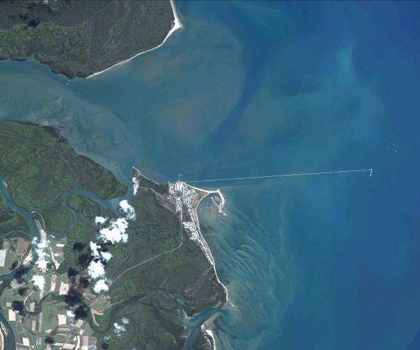
4 The Lucinda Jetty Coastal Observatory N Hinchinbrook Channel Herbert River Estuary Lucinda Jetty LJCO The location of the LJCO is ideal to monitor and characterize the optical km properties in a coastal system where the sources of particulate and dissolved matter substantially vary during the tidal and seasonal cycles.
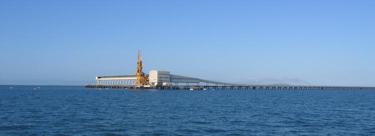
5 Lucinda Jetty from the water
6 Lucinda Jetty: Northern Dolphin

7 Lucinda Jetty: Northern Dolphin

8 Sketch of LJCO facility Met station Above-water radiometry CIMEL SeaPRISM Satlantic HyperOCR Instrument telemetry Power supply UPS NextG Router Linux Server WETLabs DAPCS PC controller Automated winch Underwater optics WETLabs WQM WETLabs CDOM fluorometer. WETLabs ac-s WETLabs BB9

9 LJCO facility
.")
10 Instrumentation: Above-water radiometry and aerosol characterization CIMEL-SeaPRISM a CIMEL CE-318 automated sunphotometer modified to perform above-water radiometric measurements in addition to the regular atmospheric measurements defined for NASA s Aerosol Robotic Network (AERONET). autonomously perform multiple skyand sea-radiance observations at programmable viewing and azimuth angles at nine centre wavelengths in the nm spectral range. SeaPRISM sea-viewing measurements are performed every 15 minutes with the objective of collecting data between 8 AM and 4 PM local time.

11 Instrumentation: Above-water radiometry and aerosol characterization CIMEL-SeaPRISM SeaPRISM data is collected, processed following the AERONET- OC common protocols and archived at NASA. Derived products are accessible through a Web interface under a specified data policy.
 WET Labs Wetstar chromophoric dissolved organic matter (CDOM) fluorometer.")
12 Instrumentation: inherent optical properties of the water column Optical package is deployed at the Jetty to characterize the Inherent optical properties of these waters: WET Labs WQM (integrated sensors for conductivity, temperature, pressure, dissolved oxygen, chlorophyll fluorometer, and turbidity) WET Labs Wetstar chromophoric dissolved organic matter (CDOM) fluorometer. One WETLabs ac-s spectral absorption meter (10- cm path length) will used for the acquisition of in situ measures of the total and dissolved absorption and attenuation coefficients. A WETLabs BB9 will be provide measures of total backscattering coefficients. Data is acquired in continuous mode at a nominal depth of ~1.5-2 m. We have two identical sets to be hot-swapped for maintenance and calibration


13 Instrumentation: ancillary information on weather and sky and sea conditions Weather conditions at the site are measured using a Vaisala WXT520 multi parameter instrument which measures barometric pressure, humidity, precipitation, air temperature, wind speed and direction. Two hemispherical cameras to capture a full sky view and a sea state information for use in post processing and interpretation of radiometric data

14 Maintenance and calibration Antibiofouling system Sensor systems are surrounded by copper either by copper shielding or adhesive backed copper tape WETLabs WQM utilizes the bio-wiper TM active cleaning and protection system Servicing and calibration The instruments are serviced on a fortnightly basis for cleaning of the SeaPRISM and in water optical packages. The SeaPRISM is calibrated by NASA following the AERONET-OC protocols prior and following each 6-12 months deployment. Only after the post deployment calibration the data will be processed to L2 and released after QA/QC.. Following instrument changeover the in situ optical instruments are returned to the laboratory for cleaning, calibration and reapplication of anti fouling copper coatings. All instruments are tested and calibrated with MilliQ water prior to each deployment.
15 Discrete measurements of bio-optical and biogeochemical data (ideally) on 1 to 2 week basis 1. near-water surface sampling 1. Biogeochemical data (to match instrument package - performed at CMAR laboratories in Hobart, as for all IMOS reference stations): 1. phytoplankton pigments by HPLC 2. total suspended solids (organic and mineral fractions) 3. Nutrients 4. TOC, DOC and POC (TBD) 2. Spectrophotometric light absorption by : 1. total particulate matter & phytoplankton pigments (providing nonalgal particulate matter absorption) 2. coloured dissolved organic matter. 2. Underwater light measurements: 1. Up and downwelling radiance/irradiance measurements (incl profiles for k d ) with Satlantic Hyper OCS tethered profiling system 2. LISST-100 particle sizing and refractive index
. Computers and communication devices are powered via a UPS.")
16 Data Acquisition and processing Controllers and telemetry Data from all the instruments is acquired in real time or in delayed mode using a mix of instrument controllers, loggers, a rack mounted Dell PowerEdge 2950 Linux Server and an Advantech ARK PC installed in an air-conditioned cabinet (25 C). Computers and communication devices are powered via a UPS. Remote control over circuit switching is obtained through the use of a power distribution unit allowing devices to be remotely powered on and off via an Ethernet interface.

17 Data Acquisition and processing Controllers and telemetry Network connectivity is provided thorough a broadband connection on Telstra's NextG Mobile Network. Static IP addresses are provided to all the devices installed on site by a CISCO VPN gateway allowing direct connection to the CSIRO network for data transfer and acquisition. Connectivity of all the devices at LJCO to the network is monitored by Big Brother network monitoring software. In the event of failure and SMS alert messages are automatically generated.
18 Data Acquisition and processing Data processing and access The raw data-streams for the in situ water optical package, the Satlantic HyperOCR and the weather data are uploaded via NextG broadband to CSIRO s data storage in Canberra. After pre-processing and QA/QC protocols are applied to each data stream, the near real time data will be packaged into IMOS compatible netcdf files and uploaded to emii (the IMOS data and information facility) for archiving and distribution. When the provisioning phase of the data streams is completed all the data streams generated at LJCO will be made freely available according to the IMOS data policy. As all IMOS data, LJCO data will be accessible through the IMOS Ocean Portal [ The SeaPRISM derived data products are accessible through the AERONET-OC web page at NASA Goddard Space Flight Center [ March Temperature (Deg C) Relative Humidity (%) Barometric Pressure (mb) Max Wind Gust (Km/h) 03-March March March Day in GMT 06-March March March March- 2010
19 Applications of LJCO data Validation of coastal-ocean colour products LJCO delivers continuous in situ measurements for the validation of coastal-ocean colour products in the GBR. The match up analysis of satellite retrievals vs. in situ measurements will enable the assessment of accuracy for aerosol optical pro perties, normalized waterleaving radiances, water inherent optical properties and biogeochemical concentrations. The accuracy of atmospheric correction algorithms will be evaluated using the SeaPRISM data stream i.e. water leaving radiance (or remote sensing reflectance) and atmospheric optical thickness, as well as ancillary weather and sky information.
20 Applications of LJCO data Validation of coastal-ocean colour products LJCO delivers continuous in situ measurements for the validation of coastal-ocean colour products in the GBR. The match up analysis of satellite retrievals vs. in situ measurements will enable the assessment of accuracy for aerosol optical pro perties, normalized water-leaving radiances, water inherent optical properties and biogeochemical concentrations. The accuracy of the algorithms for the retrieval of optical properties from ocean colour data (i.e. absorption and scattering, apportioned to phytoplankton, dissolved and non-algal particulate matter) will be quantified using the inherent optical properties estimated from the instruments data collected with ac-s and BB9. The accuracy of ocean colour algorithms for the retrieval of biogeochemical quantities will be assessed using the laboratorybased measurements of concentrations of chlorophyll, coloured dissolved organic matter and particulate matter from direct sampling of the water column.
21 Applications of LJCO data Process studies In addition to the validation activities the combined bio-optical observations will be useful for a variety of process studies such as : particle and phytoplankton temporal dynamics (e.g. assessing diurnal to seasonal variability), modeling of the underwater light climate for primary production, identifying optical proxies linking optical observations to biogeochemical properties and radiative transfer modeling studies to derive optical closure between inherent and apparent optical properties. These studies will benefit from the broad range of conditions occurring at this site where the sources of particulate and dissolved matter substantially vary during the tidal and seasonal cycles due to the interaction of the Herbert River, the Hinchinbrook Channel and the costal waters of the GBR lagoon /10/09 03:00 29/10/09 06:00 29/10/09 09:00 Depth (m) Salinity (PSU) CHL (ug/l) 29/10/09 12:00 29/10/09 15:00 Temp (C) Turbidity (NTU) 29/10/09 18:00 29/10/09 21:00 30/10/09 00: /10/09 03:00


22

23 And then cyclone Yasi paid a visit Feb 2011

24 After Cyclone Yasi: Jan 2011 Lucinda Jetty: Northern Dolphin We are rebuilding this cal-val facility for OCM-2, VIIRS, OLCI, etc.
25 Match up results MERIS Chlorophyll algorithms Results from PhD research of David Blondeau-Patissier
26 Algorithms tested in PhD research David B-P. 1. MERIS FUB- WeW 1-step procedure (implicit) 2. MERIS FUB- WeW 2-step procedure (explicit) 3. MERIS Case-2 regional 4. MERIS Standard Algal 2 (limited match-ups because less Level 2 data than Level 1 for CLW archive) 5. MERIS Standard Algal 1 (same as above) (Note CSIRO s ANN Atcor + adaptive LMI algorithm is tested in Round Robin-presented on Friday)
27 Products tested Chl TSS No CDOM for this match-up analysis
28 Differences in algorithms For both the MERIS standard L2 (standard) and Case-2 Regional, the water properties were retrieved following the atmospheric correction. In the FUB-WeW implicit (1-step), the concentrations are directly derived from the TOA radiances, without any separate atmospheric correction. In the FUB-WeW explicit (2-step), concentrations are derived from the bottom-of-atmosphere. There is an atmospheric correction of the signal in that case prior the derivation of the concentrations. This latter method should be more accurate but it seems to be more sensitive to error propagation following atmospheric correction
29 Method In situ dataset limited to Total of 1804 stations from AIMS, CLW, GBRMPA, JCU etc (not all with CHL) 45% of this dataset sampled during wet season 30% of samples had TSS 15% of samples had CDOM
30 Method The selected MERIS images were within 5 hours from the in situ sampling time, in UTC The MERIS images were not reprojected MERIS algorithms were computed using the BEAM toolbox The validation was performed on the closest MERIS pixel to the recorded in situ location so this validation was performed on a single RR pixel. MERIS L2 quality and science flags were applied.

31 Map of the 80 match-up locations that are within 5 hours of the MERIS overpasses from the CLW archive.
32
33
34

35
36
37
38
39
40
41
42
43
44

45 MERIS Coastal water algorithms and the GBR Introduction Method Results Summary The same MERIS scene processing with 4 different algorithms provides different estimates of Chlorophyll-a concentrations Corrected for GBR MERIS FUB-1 step: best performing algorithm for the retrieval of CHL David Blondeau-Patissier, CLW Divisional Seminar, 28 th September 2011 Phytoplankton blooms in the GBR waters
 Introduction Method Results Summary Burdekin")


46 Princess Charlotte Bay January 2007 Multi-annual monthly Chlorophyll (MERIS) Introduction Method Results Summary Burdekin River January Chlorophyll multi-annual mean and standard deviation ( for the Great Barrier Reef coastal and oligotrophic lagoonal waters ) David Blondeau-Patissier, CLW Divisional Seminar, 28 th September 2011 Phytoplankton blooms in the GBR waters

47 The DALEC for Cal-Va Burdekin River plume February 2008
48 To acquire spatial coverage for ship-based deployment, the Dynamic Above water radiance (L) and irradiance (E) Collector (DALEC) hyperspectral radiometer was developed by IMO in Perth (WA). This 3-channel spectroradiometer measures reflected light from in the water column across 256 different wavelength bins, from approximately 380 to 900 nm (UV/ VIS/NIR). The DALEC is radiometrically calibrated Full attitudional RT sensor alignment Mounted on Australian Ocean research vessel: Southern Surveyor for circum Australia and Southern Ocean transects.

49 DALEC fully automated positioning spectroradiometer (Ed, Lw sky,luw)

50

51
52
53 Summary Situation Australia CSIRO+IMOS MERIS, MODIS, OCM-2 VIIRS, OLCI etc.. LJCO for systematic coastal observations DALEC for systematic radiance and R around Australia and to Antarctica Cruises around Australia IMOS Bio-Optical Working Group equipping buoys Wetlabs WQM + fluoroprobes etc. SeaWiFS, MODIS and MERIS processed using ANN based atcor Adaptive SIOP LMI algorithms (=sensor agnostic) + standard products through supercomputing facility All data made available through IMOS AODN portal: [
Zu-Tao Ou-Yang Center for Global Change and Earth Observation Michigan State University
 Zu-Tao Ou-Yang Center for Global Change and Earth Observation Michigan State University Ocean Color: Spectral Visible Radiometry Color of the ocean contains latent information on the water qualitycdom,
Developments in Operationalising Earth Observation of Coastal Waters in Australia using MERIS and MODIS
 Developments in Operationalising Earth Observation of Coastal Waters in Australia using MERIS and MODIS Arnold Dekker Based on work by: Vittorio Brando, Thomas Schroeder, Kadija Oubelkheir, Young Je Park,
NASA Satellite Ocean Color Timeseries
 NASA Satellite Ocean Color Timeseries Bryan Franz and the NASA Ocean Biology Processing Group International Ocean Color Science Meeting 6-8 May 2013 Ocean Biology Processing Group Multi-mission Ocean Color
Future remote sensors for chlorophyll a. Dimitry Van der Zande, Quinten Vanhellemont & Kevin Ruddick
 Future remote sensors for chlorophyll a Dimitry Van der Zande, Quinten Vanhellemont & Kevin Ruddick Workshop Scheldt Commission: eutrophication 20 th October 2016 Ocean colour from space ESA MERIS 7 May
Application of Gliders for Near-Real Time METOC Data Collection Capability for Battlespace Characterization
 DISTRIBUTION STATEMENT A: Approved for public release; distribution is unlimited. Application of Gliders for Near-Real Time METOC Data Collection Capability for Battlespace Characterization Charles Trees
Estimation of chlorophyll-a concentration in estuarine waters:
 Estimation of chlorophyll-a concentration in estuarine waters: case study of the Pearl River estuary Yuanzhi Zhang *, Chuqun Chen #, Hongsheng Zhang *, Xiaofei*, Chen Guiying Chen# *Institute of Space
Optical Detection and Assessment of the Harmful Alga, Karenia brevis
 Optical Detection and Assessment of the Harmful Alga, Karenia brevis Steven E. Lohrenz Department of Marine Science The University of Southern Mississippi 1020 Balch Boulevard Stennis Space Center, MS
NASA ocean color processing and data analysis support for SGLI
 NASA ocean color processing and data analysis support for SGLI Bryan Franz Ocean Biology Processing Group NASA Goddard Space Flight Center JAXA GCOM-C PI Workshop. January 2014 Collaborators Ziauddin Ahmad
INHERENT OPTICAL PROPERTIES IN NEW ENGLAND COASTAL WATERS: DECOMPOSITION INTO CONTRIBUTIONS FROM OPTICALLY IMPORTANT CONSTITUENTS
 ABSTRACT INHERENT OPTICAL PROPERTIES IN NEW ENGLAND COASTAL WATERS: DECOMPOSITION INTO CONTRIBUTIONS FROM OPTICALLY IMPORTANT CONSTITUENTS Morrison, J. R. and Sosik, H. M. Woods Hole Oceanographic Institution,
Appendix A. Proposal Format. HICO Data User s Proposal
 Appendix A. Proposal Format HICO Data User s Proposal Title of Proposal: A hyperspectral atmospheric correction algorithm to retrieve water-leaving radiance signal from HICO data Principal Investigator
Application of Geostationary Satellite Images to the monitoring of dynamic variations
 The 1 st International Ocean Colour Science Meeting Darmstadt, Germany, 6-8 May 2013 Application of Geostationary Satellite Images to the monitoring of dynamic variations Jong-Kuk Choi, Young Je Park and
7. Requirements for future ocean color satellite sensors. Menghua Wang, IOCCG Lecture Series Atmospheric Correction
 7. Requirements for future ocean color satellite sensors Significant efforts are needed for improvements of water color products in the inland & coastal regions: Turbid Waters (violation of the NIR black
Airborne Hyperspectral Potential for Coastal Biogeochemistry of the Scheldt Estuary and Plume
 Airborne Hyperspectral Potential for Coastal Biogeochemistry of the Scheldt Estuary and Plume M. Shimoni & M. Acheroy Signal and Image Centre, Royal Military Academy; D. Sirjacobs & S. Djenidi GeoHydrodynamic
BIO-OPTICAL SENSORS FOR PROFILING FLOATS
 BIO-OPTICAL SENSORS FOR PROFILING FLOATS J. Ronald V. Zaneveld Western Environmental Technology Laboratories, Inc. P.O. Box 518, Philomath, OR 97370, U.S.A. FAX:1-541-929-5277 e-mail:ron@wetlabs.com Introduction
Study of Water Quality using Satellite data
 2nd Workshop on Parameterization of Lakes in Numerical Weather Prediction and Climate Modelling Study of Water Quality using Satellite data M. Potes, M. J. Costa (Évora Geophysics Centre, PORTUGAL) This
 Fernando Gilbes 1, William Hernández, Natlee Hernández, José Martínez, and Vilmaliz Rodriguez Geological and Environmental Remote Sensing Lab Department of Geology University of Puerto Rico at Mayagüez
Remote sensing of total suspended sediment within lakes Onoke and Wairarapa
 Remote sensing of total suspended sediment within lakes Onoke and Wairarapa Introduction Remote sensing can provide synoptic monitoring of water quality and temperature (e.g., Kloiber et al. 2002, Dekker
Mapping water constituents concentrations in estuaries using MERIS full resolution satellite data
 Mapping water constituents concentrations in estuaries using MERIS full resolution satellite data David Doxaran, Marcel Babin Laboratoire d Océanographie de Villefranche UMR 7093 CNRS - FRANCE In collaboration
NASA Workshop for Remote Sensing of Coastal & Inland Waters
 NASA Workshop for Remote Sensing of Coastal & Inland Waters Madison, Wisconsin June 20-22, 2012 Dr. Robert Shuchman, MTRI George Leshkevich, NOAA GLERL Contributors: Michael Sayers, MTRI Colin Brooks,
V. Brando, A. Dekker, A. Marks, Y. Qin & K. Oubelkheir. CSIRO Land and Water, Canberra
 Chlorophyll and suspended sediment assessment in a macrotidal tropical estuary adjacent to the Great Barrier Reef: spatial and temporal assessment using remote sensing V. Brando, A. Dekker, A. Marks, Y.
vertical profiling systems
 vertical profiling systems Automated water quality monitoring and telemetry systems providing 24/7 water column profiling and remote data delivery for freshwater and marine environments vertical profiling
OPTICAL WATER TYPES & LIMNADES
 Global Observatory of Lake Response to Environmental Change Water Quality Information for the Benefit of Society University of Stirling, 29-31 August 2018 OPTICAL WATER TYPES & LIMNADES V. SPYRAKOS, P
FERNANDO GILBES REPORT (Performance period: October 1, 2006 to March 31, 2007)
") FERNANDO GILBES REPORT (Performance period: October 1, 2006 to March 31, 2007) 1. RESEARCH COMPONENT Thrust: Coastal Remote Sensing Area of Research within the Thrust: Bio-optical properties and ocean
FERNANDO GILBES REPORT (Performance period: October 1, 2006 to March 31, 2007) 1. RESEARCH COMPONENT Thrust: Coastal Remote Sensing Area of Research within the Thrust: Bio-optical properties and ocean
Ocean Optics XVI Conference, Santa Fe, New Mexico, November 18-22, 2002
 BIO-OPTICAL EVIDENCE OF LAND-SEA INTERACTIONS IN THE WESTERN COAST OF PUERTO RICO Fernando Gilbes 1, Roy A. Armstrong 2, Richard L. Miller 3, Carlos E. Del Castillo 3, Marcos Rosado 2, and Nazario Ramirez
Monitoring water quality of the Southeastern Mediterranean sea using remote sensing
 Monitoring water quality of the Southeastern Mediterranean sea using remote sensing Tamir Caras The Remote Sensing Laboratory Jacob Blaustein Institutes for Desert Research Ben-Gurion University of the
Development of Carbon Data Products for the Coastal Ocean: Implications for Advanced Ocean Color Sensors
 Development of Carbon Data Products for the Coastal Ocean: Implications for Advanced Ocean Color Sensors Antonio Mannino NASA Goddard Space Flight Center Greenbelt, Maryland USA Field Activities & DOC
Water property monitoring and assessment for China s inland Lake Taihu from
 Water property monitoring and assessment for China s inland Lake Taihu from MODIS-Aqua measurements By Wang M, W Shi and J Tan, Remote Sensing of Environment 115 (2011) 841-854 Wei Wang 9 December 2011
In Situ Chlorophyll Fluorescence Observations on NERACOOS Mooring A01: Revised Data Flagging and Changing Phenology
 In Situ Chlorophyll Fluorescence Observations on NERACOOS Mooring A01: Revised Data Flagging and Changing Phenology Massachusetts Water Resources Authority Environmental Quality Department Report 2016-15
Application of OCEANSAT-2 2 data to study the CASE- 2 waters in the North-Eastern Mediterranean sea (NEMO-C2W)
") Application of OCEANSAT-2 2 data to study the CASE- 2 waters in the North-Eastern Mediterranean sea (NEMO-C2W) IIA PI: Stefano Pignatti Italian National Research Council Atmospheric Pollution E-mail: rosa.cavalli@lara.rm.cnr.it
Application of OCEANSAT-2 2 data to study the CASE- 2 waters in the North-Eastern Mediterranean sea (NEMO-C2W) IIA PI: Stefano Pignatti Italian National Research Council Atmospheric Pollution E-mail: rosa.cavalli@lara.rm.cnr.it
Grant Number: N LONG-TERM GOALS
 Identification and Quantification of the Temporal and Spatial Scales of Variability in Particulate and Dissolved Material Associated with Specific Land-Use Activities in the Penobscot River System Collin
Global Processing and Products from MERIS Full Resolution Data for the Coastal Zone. User Consultation Meeting
 Global Processing and Products from MERIS Full Resolution Data for the Coastal Zone User Consultation Meeting 16-17.11.2010 Frascati CoastColour UCM1 * Frascati * 16.- 17.11.2010 CoastColour is ESAs initiative
Great Lakes Remote Sensing Algorithms
 Great Lakes Remote Sensing Algorithms Status, Comparisons, and Future Directions Robert Shuchman MTRI Mike Sayers MTRI George Leshkevich NOAA/GLERL Barry Lesht JGLR/Assoc. Editor Caren Binding Environment
Eyes Over Puget Sound: Producing Validated Satellite Products to Support Rapid Water Quality Assessments in Puget Sound
 Western Washington University Western CEDAR Salish Sea Ecosystem Conference 2014 Salish Sea Ecosystem Conference (Seattle, Wash.) May 2nd, 10:30 AM - 12:00 PM Eyes Over Puget Sound: Producing Validated
Global Lakes Sentinel Services GLASS-S3VT
 www.glass-project.eu Global Lakes Sentinel Services GLASS-S3VT Water Insight (A. Hommersom, S. Peters, K. Poser), SYKE (S. Koponen, K. Kallio), EOMAP (T. Heege, K. Schenk, S. Ohlendorf), VU University
Distribution and Cycling of Dissolved Organic Carbon and Colored Dissolved Organic Carbon on the West Florida Shelf
 Distribution and Cycling of Dissolved Organic Carbon and Colored Dissolved Organic Carbon on the West Florida Shelf Dr. Paula Coble College of Marine Science University of South Florida 10 7 th Ave South
Ocean Color - Simultaneous Marine and Aerosol Retrieval Tool (OC-SMART)
") Ocean Color - Simultaneous Marine and Aerosol Retrieval Tool (OC-SMART) Yongzhen Fan, Nan Chen, Wei Li, and Knut Stamnes Light and Life Laboratory, Stevens Institute of Technology, Hoboken, NJ, USA OC-SMART
Ocean Color - Simultaneous Marine and Aerosol Retrieval Tool (OC-SMART) Yongzhen Fan, Nan Chen, Wei Li, and Knut Stamnes Light and Life Laboratory, Stevens Institute of Technology, Hoboken, NJ, USA OC-SMART
Marginal Ice Zone: Biogeochemical Sampling with Gliders
 DISTRIBUTION STATEMENT A. Approved for public release; distribution is unlimited. Marginal Ice Zone: Biogeochemical Sampling with Gliders Mary Jane Perry School of Marine Sciences University of Maine Ira
An understanding biological variability in the open ocean (GlobCOLOUR project) Dr Samantha Lavender
 Dr Samantha Lavender") An understanding biological variability in the open ocean (GlobCOLOUR project) Dr Samantha Lavender SEOES & Marine Institute, University of Plymouth ARGANS Limited Tamar Science Park, Plymouth s.lavender@plymouth.ac.uk
An understanding biological variability in the open ocean (GlobCOLOUR project) Dr Samantha Lavender SEOES & Marine Institute, University of Plymouth ARGANS Limited Tamar Science Park, Plymouth s.lavender@plymouth.ac.uk
Abstract/Project Summary
 Abstract/Project Summary Four large lakes- Sardis, Enid, Grenada, and the Ross Barnett Reservoir in Mississippi and the Grand Bay at the MS-AL gulf coast serve as important economic and recreational resources
USE OF THE NEW OLCI AND SLSTR BANDS FOR ATMOSPHERIC CORRECTION OVER TURBID COASTAL AND INLAND WATERS
 USE OF THE NEW AND SLSTR BANDS FOR ATMOSPHERIC CORRECTION OVER TURBID COASTAL AND INLAND WATERS Kevin Ruddick and Quinten Vanhellemont Royal Belgian Institute for Natural Sciences (RBINS), Operational
Satellite based inland and coastal water quality monitoring
 Satellite based inland and coastal water quality monitoring Harmonized transnational, long-term and near-real time space based solutions. Thomas Heege CEO EOMAP Germany Earth Observation & Mapping Inland
Use of remote sensing in assessing the impacts of ocean acidification
 Use of remote sensing in assessing the impacts of ocean acidification William M. Balch Bigelow Laboratory for Ocean Sciences W. Boothbay Harbor, ME 04575 Thanks to so many D. Drapeau, B. Bowler, E. Booth
Collaborative Earth-Observation Infrastructure for Coastal and Coral Reef Monitoring & Management Stuart Phinn and Chris Roelfsema
 2015 International Ocean Colour Science (IOCS), San Francisco June 15-18 Collaborative Earth-Observation Infrastructure for Coastal and Coral Reef Monitoring & Management Stuart Phinn and Chris Roelfsema..
USING MERIS DATA FOR THE RETRIEVAL OF CHL A, CDOM AND TSS VALUES IN THE GULF OF FINLAND AND LAKE LOHJANJÄRVI
 USING MERIS DATA FOR THE RETRIEVA OF CH A, CDOM AND TSS VAUES IN THE GUF OF FINAND AND AKE OHJANJÄRVI Sampsa Koponen 1, Jenni Vepsäläinen 2, Jouni Pulliainen 1, Kari Kallio 2, Timo Pyhälahti 2, Antti indfors
Ocean Diurnal Variations Measured by the Korean Geostationary Ocean Color Imager
 Ocean Diurnal Variations Measured by the Korean Geostationary Ocean Color Imager Menghua Wang 1, Lide Jiang 1,2, Seunghyun Son 1,2, & Wei Shi 1,2 1 NOAA/NESDIS Center for Satellite Applications & Research
The nature (peculiarities) of biooptical/biogeochemical. measurements in the context of Argo QC and data management.
 of biooptical/biogeochemical. measurements in the context of Argo QC and data management.") The nature (peculiarities) of biooptical/biogeochemical data and of their measurements in the context of Argo QC and data management Hervé Claustre Prerequisite for Bio-Argo DM: We should follow as much
The nature (peculiarities) of biooptical/biogeochemical data and of their measurements in the context of Argo QC and data management Hervé Claustre Prerequisite for Bio-Argo DM: We should follow as much
EVALUATION OF TWO SITES FOR OCEAN COLOR VALIDATION IN THE TURBID WATERS OF THE RÍO DE LA PLATA (ARGENTINA)
") EVALUATION OF TWO SITES FOR OCEAN COLOR VALIDATION IN THE TURBID WATERS OF THE RÍO DE LA PLATA (ARGENTINA) Dogliotti, A. I. (1), Gossn, J. I. (1), Vanhellemont, Q. (2), Ruddick, K.G. (2) (1) (2) Instituto
EVALUATION OF TWO SITES FOR OCEAN COLOR VALIDATION IN THE TURBID WATERS OF THE RÍO DE LA PLATA (ARGENTINA) Dogliotti, A. I. (1), Gossn, J. I. (1), Vanhellemont, Q. (2), Ruddick, K.G. (2) (1) (2) Instituto
SOOP SOPs AND QCs from Spirit of Tasmania 1 Autonomous monitoring system
 SOOP SOPs AND QCs from Spirit of Tasmania 1 Autonomous monitoring system Randall Lee and Emilie Laurent, Environmental Solutions Centre of Applied Sciences EPA Victoria, Macleod Daily watch on Port Phillip
Assessing The Role Of Small-Scale Bio-Optical And Bio-Acoustical Distributions In Upper Ocean Biological And Optical Processes
 Assessing The Role Of Small-Scale Bio-Optical And Bio-Acoustical Distributions In Upper Ocean Biological And Optical Processes Timothy J. Cowles College of Oceanic and Atmospheric Sciences 104 Oceanography
METODOLOGIE E APPROCCI PER OSSERVAZIONI IPERSPETTRALI IN ACQUE COSTIERE E INTERNE
 Data Exploitation della missione PRISMA, precursore delle missioni iperspettrali nazionali Roma, 1-3 marzo 2017 METODOLOGIE E APPROCCI PER OSSERVAZIONI IPERSPETTRALI IN ACQUE COSTIERE E INTERNE Federica
Harmful Algal Blooms (HABs) 2 methods
 2 methods") Harmful Algal Blooms (HABs) 2 methods Richard P. Stumpf NOAA, National Ocean Service HAB occurrences worldwide Image from whoi.edu/redtide Remote Sensing for HAB Detection: Does the Bloom Change Water
Harmful Algal Blooms (HABs) 2 methods Richard P. Stumpf NOAA, National Ocean Service HAB occurrences worldwide Image from whoi.edu/redtide Remote Sensing for HAB Detection: Does the Bloom Change Water
OCEAN COLOR PRODUCTS RETRIEVAL AND VALIDATION AROUND CHINA COAST WITH MODIS
 OCEAN COLOR PRODUCTS RETRIEVAL AND VALIDATION AROUND CHINA COAST WITH MODIS L. Sun a, M. Guo b, X. Wang b a National Satellite Meteorological Center, China Meteorological Administration, No.46 South Avenue
Contract Number: N C LONG-TERM GOALS
 Identification and Quantification of the Temporal and Spatial Scales of Variability in Particulate and Dissolved Material Associated with Specific Land-Use Activities in the Penobscot River System Andrew
Contract Number: N C0133, N C
 Temporal and Spatial Scales of Terrestrially-derived Particulate and Dissolved Material in the Penobscot River System: Quantifying Conserved and Nonconserved Optical Properties and Transformations within
Chemical and Physical Analysis of the Cape Fear Estuary
 The Cape Fear River Chemical and Physical Analysis of the Cape Fear Estuary The Cape Fear River (CFR), the most industrialized of all North Carolina s rivers, winds for over miles through the heart of
Massachusetts Water Resources Authority Environmental Quality Department Report
 In Situ Bio-Optical Observations on NERACOOS Buoy A01 (2005-2017): multichannel calibrated chlorophyll fluorescence, turbidity, and multispectral incident irradiance and upwelling radiance Massachusetts
MERIS VALIDATION WITH RESPECT TO OPERATIONAL MONITORING NEEDS IN THE NORTH AND BALTIC SEA
 MERIS VALIDATION WITH RESPECT TO OPERATIONAL MONITORING NEEDS IN THE NORTH AND BALTIC SEA Kerstin Stelzer (1), Jasmin Geißler (1), Carsten Brockmann (1), Holger Klein (2), Jeanette Göbel (3), Anu Reinart
In situ Requirements for Ocean Color System Vicarious Calibration: A Review
 In situ Requirements for Ocean Color System Vicarious Calibration: A Review Background literature G. Zibordi, Ispra, Italy G.Zibordi, F. Mélin, K.J. Voss, B.C. Johnson, B.A. Franz, E. Kwiatkowska, J.P.
Pattern recognition of marine provinces
 International Journal of Remote Sensing Vol. 26, No. 7, 10 April 2005, 1499 1503 Pattern recognition of marine provinces K.-H. SZEKIELDA The Graduate School and University Center, Earth and Environmental
vertical profiling systems
 vertical profiling systems Automated water quality monitoring and telemetry systems providing 24/7 water column profiling and remote data delivery for freshwater and marine environments vertical profiling
Ocean Color System Vicarious Calibration: requirements on in situ data and sites
 Ocean Color : requirements on in situ data and sites G. Zibordi Joint Research Centre, Ispra, Italy Several elements are taken from Requirements and Strategies for In Situ Radiometry in Support of Satellite
MERIS PERFORMANCE IN THE EAST CHINA SEAS: EVALUATION OF ATMOSPHERIC CORRECTION AND OPTICAL INVERSION ALGORITHMS
 MERIS PERFORMANCE IN THE EAST CHINA SEAS: EVALUATION OF ATMOSPHERIC CORRECTION AND OPTICAL INVERSION ALGORITHMS Ming-Xia HE 1, Shuangyan He 1, Lianbo Hu 1, Yunfei Wang 1, Qian Yang 1, Tinglu Zhang 1 Wenzhong
Determination of ph and pco2 - new autonomous instrumentation for Ferrybox
 Determination of ph and pco2 - new autonomous instrumentation for Ferrybox Kai Sørensen 1, Emanuele Reggiani 1, Michel Masson 2, Andreas Krüger 2, Marit Norli 1, Richard Bellerby 1, Pierre Jaccard 1, Evgenij
Cleveland Bay Marine Water Quality (Turbidity and Available Light) Monitoring Plan
 Monitoring Plan") Cleveland Bay Marine Water Quality (Turbidity and Available Light) Monitoring Plan 1 BACKGROUND Port of Townsville Limited (PoTL) administers the Port of Townsville, a general purpose cargo port in North
Cleveland Bay Marine Water Quality (Turbidity and Available Light) Monitoring Plan 1 BACKGROUND Port of Townsville Limited (PoTL) administers the Port of Townsville, a general purpose cargo port in North
GulfCarbon 2 CRUISE PLAN R/V Cape Hatteras 19 April 1 May 2009
 Satellite Assessment of CO2 Distribution, Variability and Flux and Understanding of Control Mechanisms in a River Dominated Ocean Margin www.gulfcarbon.org Overview: GulfCarbon 2 CRUISE PLAN R/V Cape Hatteras
ereefsoptical and biogeochemical model. CSIRO OCEANS AND ATMOSPHERE FLAGSHIP
 ereefsoptical and biogeochemical model. CSIRO OCEANS AND ATMOSPHERE FLAGSHIP 2 Presentation title Presenter name BGC state variables: - 10 dissolved - 22 living particulate - 11 non-living part. -6 epibenthic.
Using satellite-derived optical data to improve simulation of the 3D light field in a biogeochemical model
 Using satellite-derived optical data to improve simulation of the 3D light field in a biogeochemical model Barbara J. Robson, Nagur Cherukuru and Vittorio Brando barbara.robson@csiro.au CSIRO Land and
Update on NOAA Ocean Color Activities: VIIRS et al.
 Update on NOAA Ocean Color Activities: VIIRS et al. Cara Wilson, NOAA-NMFS Menghua Wang & Paul DiGiacomo, NOAA-NESDIS International Ocean Color Science Meeting Darmstadt, Germany, 6 May 2013 NMFS: National
Ecohab: Hyperspectral Optical Properties of Red-Tide Blooms
 Ecohab: Hyperspectral Optical Properties of Red-Tide Blooms Helmut Maske Center for Hydro-Optics and Remote Sensing San Diego State University 6505 Alvarado Rd., Suite 206 San Diego, CA 92120 phone: (619)
Inland and coastal water quality retrieval Some challenges and new opportunities
 Inland and coastal water quality retrieval Some challenges and new opportunities Els Knaeps, Dries Raymaekers, Sindy Sterckx (VITO, Belgium) Kevin Ruddick, Bouchra Nechad (MUMM, Belgium) Ana Dogliotti
What we can measure vs. What we want to know.
 SCIENTIFIC AND TECHNICAL ADVISORY COMMITTEE 18 September 2015 What we can measure vs. What we want to know. William Ullman School of Marine Science and Policy University of Delaware, Lewes 9/15/2015 Inland
MERIS PRODUCTS OVER LARGE EUROPEAN LAKES - COMPARISON WITH MEASURED DATA ABOUT AEROSOL AND WATER QUALITY
 MERIS PRODUCTS OVER LARGE EUROPEAN LAKES - COMPARISON WITH MEASURED DATA ABOUT AEROSOL AND WATER QUALITY A. Reinart (1), H. Ohvril (2), K. Alikas (1), P. Ibrus (1), H. Teral (2), K. Valdmets (1), O. Okulov
ANALYZING THE SPATIAL AND TEMPORAL VARIABILITY OF WATER TURBIDITY IN THE COASTAL AREAS OF THE UAE USING MODIS SATELLITE DATA
 ANALYZING THE SPATIAL AND TEMPORAL VARIABILITY OF WATER TURBIDITY IN THE COASTAL AREAS OF THE UAE USING MODIS SATELLITE DATA Muna R. Al Kaabi, Jacinto Estima and Hosni Ghedira Ocean Color Group - Earth
Synergy between polar-orbiting and geostationary sensors:
 Synergy between polar-orbiting and geostationary sensors: Remote sensing of the ocean at high spatial and high temporal resolution. Quinten Vanhellemont, Griet Neukermans, Kevin Ruddick Management Unit
A Unified Approach to Remote Estimation of Chlorophyll a Concentration in Complex Inland, Estuarine, and Coastal waters
 A Unified Approach to Remote Estimation of Chlorophyll a Concentration in Complex Inland, Estuarine, and Coastal waters Wesley J. Moses 1, *, Anatoly A. Gitelson 1, Alexander A. Gilerson 2, and Daniela
Carbon dynamics in inland and coastal ecosystems. Dragon 3 ID 10561
 Carbon dynamics in inland and coastal ecosystems Dragon 3 ID 10561 Project Team Ronghua Ma Hongtao Duan Yuchao Zhang Juhua Luo Lin Chen Steven Loiselle Alessandro Donati Claudio Rossi Project Young Scientists
Examples of the use of MERIS data in marine and land applications
 Examples of the use of MERIS data in marine and land applications Peter Regner Science, Applications & Future Technologies Department ESA/ESRIN, Frascati, Italy Examples of the use of MERIS data European
Pacific Coastal Ecology Branch Physical and Water Quality Data
 Pacific Coastal Ecology Branch Physical and Water Quality Data Data Contributors: Cheryl A. Brown, Peter Eldridge, Robert Ozretich, Anne Sigleo & David Specht CRUISES CTD profiles using (SBE 19 SEACAT)
Optical classification in contrasted coastal waters for monitoring water masses and improving the assessment of ocean color products
 Optical classification in contrasted coastal waters for monitoring water masses and improving the assessment of ocean color products Vantrepotte V., Loisel H., Mériaux X., and Dessailly D. LOG, CNRS-UMR
CS229 Project: Identifying Regions of High Turbidity in San Francisco Bay
 CS229 Project: Identifying Regions of High Turbidity in San Francisco Bay Joe Adelson December 11, 2014 Introduction Suspended sediments in oceans, seas, and estuaries shape coastal geography, provide
Establishing a SeaPRISM site on the West Coast of the United States
 1) Define a VIIRS Proxy Data Stream Establishing a SeaPRISM site on the Presenter/Affiliation: Curtiss O. Davis, OSU 2) Define the Performers: Curtiss O. Davis, Curt Vandetta, required in situ data stream
SURFACE REFLECTANCE AND UNDERWATER DOWNWELLING IRRADIANCE IN ALQUEVA RESERVOIR, SOUTHEAST PORTUGAL
 SURFACE REFLECTANCE AND UNDERWATER DOWNWELLING IRRADIANCE IN ALQUEVA RESERVOIR, SOUTHEAST PORTUGAL M. Potes, R. Salgado, M. J. Costa, M. Morais, D. Bortoli and I. Kostadinov Institute of Earth Sciences
MAPPING OF PHOTOSYNTHETIC PIGMENTS IN SPANISH RESERVOIRS
 MAPPING OF PHOTOSYNTHETIC PIGMENTS IN SPANISH RESERVOIRS Ramón Peña-Martínez, José Antonio Domínguez-Gómez, Caridad de Hoyos, Antonio Ruiz-Verdú Centro de Estudios Hidrográficos del CEDEX, Pº Bajo de la
COLLEGE OF ARTS AND SOCIAL SCIENCE ADI- KEIH Department of Geography Program Geoinformatics Master of Science degree
 COLLEGE OF ARTS AND SOCIAL SCIENCE ADI- KEIH Department of Geography Program Geoinformatics Master of Science degree Spatial and seasonal variability of phytoplankton concentration in the territorial waters
WISPSTATION: A NEW AUTONOMOUS ABOVE WATER RADIOMETER SYSTEM
 WISPSTATION: A NEW AUTONOMOUS ABOVE WATER RADIOMETER SYSTEM Steef Peters, Marnix Laanen, Philipp Groetsch, Semhar Ghezehegn, Kathrin Poser, Annelies Hommersom, Esther Dereus, Lazaros Spaias Steef Peters,
LSP: using AVHRR NDVI data and from 2003 using MODIS NBAR. Water Quality: using MSS and TM Landsat data and from 2001 using
 Land cover land use change effects on surface water quality: Integrated MODIS and SeaWiFS assessment of the Dnieper and Don River basins and their reservoirs Anatoly A. Gitelson, Wesley Moses & Daniela
Detection of redtides/habs: A Remote Sensing Perspective
 Detection of redtides/habs: A Remote Sensing Perspective P. Shanmugam 1 and Yu-Hwan Ahn 2 1 Indian Institute of Technology, Madras, India 2 Korea Ocean Research and Development Institute, Korea This presentation
Remote Sensing of Water Quality in California s Water Systems. Christine M. Lee NASA Jet Propulsion Laboratory
 Remote Sensing of Water Quality in California s Water Systems Christine M. Lee NASA Jet Propulsion Laboratory Overall vision. To advance the capability of multiple stakeholders in California s water resources
Measuring Ocean Color: The Basics
 Measuring Ocean Color: The Basics Radiation of energy from the Sun and the Earth s surface. Recall from previous lectures that the Sun (6000 K), radiates energy in three portions of the energy spectrum:
FerryBox and a new sensor for phytoplankton detection
 AquaLife 2012 FerryBox and a new sensor for phytoplankton detection Jochen Wollschläger, Maik Grunwald, Rüdiger Röttgers, Wilhelm Petersen 05.06.12 06.06.12 / Kiel Outline Introduction FerryBox Routes
Coastal Biological Data from Satellite
 Coastal Biological Data from Satellite Joji Ishizaka Nagoya University Institute for Space-Earth Environmental Research (ISEE) jishizaka@nagoya-u.jp GEOSS 2018.10.25 Kyoto Genki Terauchi UNEP/NOWPAP CEARAC,
Characterization of global ocean turbidity from Moderate Resolution Imaging Spectroradiometer ocean color observations
 JOURNAL OF GEOPHYSICAL RESEARCH, VOL. 115,, doi:10.1029/2010jc006160, 2010 Characterization of global ocean turbidity from Moderate Resolution Imaging Spectroradiometer ocean color observations Wei Shi
HAB Monitoring and Tracking. Gary & Barb Kirkpatrick & Many Others
 HAB Monitoring and Tracking Gary & Barb Kirkpatrick & Many Others This Talk Review current HABIOS monitoring plan Review current resources List needs Future vision Impediments Current Plan Terms of Reference
Hydrolab and Ott Jointly Provide Full Hydrological Monitoring Solution Presented By D J Catt
 The Hydrological Cycle - Monitoring Locations and Equipment Hydrolab Multiprobe Ott Level Senso Ott Datalogger Portable Data Collection (Vota & PDA) Ott Rain Gauge Ott Flow Sensor Hydromet Softw Ott Communication
SEA TECHNOLOGY. The Indian River Lagoon Observatory. Real-time Water Quality Data Network for Research, Education, Outreach REPRINT
 SEA TECHNOLOGY WORLDWIDE INFORMATION LEADER FOR MARINE BUSINESS, SCIENCE & ENGINEERING REPRINT The Indian River Lagoon Observatory Real-time Water Quality Data Network for Research, Education, Outreach
Remote Sensing of Water Quality in Wisconsin
 Remote Sensing of Water Quality in Wisconsin 1 Steve Greb, UW-Madison Daniela Gurlin, WDNR ----------------------------------- Wisconsin Lakes Convention April 19 th, 218 MODIS Today website are acquired
Richard C. Zimmerman, Victoria J. Hill, John Klinck Michael Dinniman Department Ocean, Earth & Atmospheric Sciences and Center for Coastal Physical
 Richard C. Zimmerman, Victoria J. Hill, John Klinck Michael Dinniman Department Ocean, Earth & Atmospheric Sciences and Center for Coastal Physical Oceanography Old Dominion University Norfolk VA 23529
Beyond the two cases of water
 44 th Intl. Liège Colloquium on Ocean Dynamics 11 May 2012 Beyond the two cases of water Water constituent retrieval algorithms and their validity ranges Odermatt, D. 1,2, Gitelson, A. 3, Brando, V.E.
How are these equations relevant to remotely sensed data? Source: earthsci.org/rockmin/rockmin.html
 Lecture 3 How does light give us information about environmental features Revision Select a different scoop from last week Post the key points as a reaction to http://www.scoop.it/t/env22-52-w2 (need to
Satellite Monitoring of Water Quality in Lake Manzalah, Egypt. Real-Time Water Quality Monitoring Workshop June St.
 Satellite Monitoring of Water Quality in Lake Manzalah, Egypt Real-Time Water Quality Monitoring Workshop June 16-17 2009 St. John s, Canada Motivation Lakes are vital component of Egypt s water resources