Floodplain Development
|
|
|
- Christian McKenzie
- 5 years ago
- Views:
Transcription
1 Floodplain Development

2
3 Floodplain Regulations State: Part 31 of Public Act 451 Local: Federal: Building Codes, Zoning and Floodplain Management Ordinances National Flood Insurance Program
4 Floodplain: What is a floodplain? That area of land adjoining a river or stream that will be inundated by a 100-year flood 100-year flood: A flood with a magnitude which has a 1 % chance of occurring or being exceeded in a given year
.")
5 Identifying Floodplains in Mapped Areas Many flood-prone communities belong to the National Flood Insurance Program, and have floodplains mapped on Flood Insurance Rate Maps (FIRM s).
6 Identifying Floodplains in Unmapped Areas The DEQ may be able to provide estimates of flood elevations on streams when floodplain maps do not exist. Information, such as a cross section of the stream is sometimes necessary to perform this service
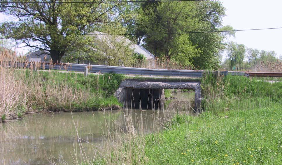
7 SO, What does a floodplain look like anyway?

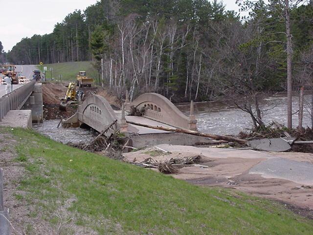
8 City of Wakefield, 2002

9 Dead River Flooding, 2003

10 Great Lakes Flooding, 2013

11 Inland Lake Flooding-Mason County in 2008
12 Inland Lakes and Stream Crossings Look for signs of fluctuating water levels. Look for control structures (dams) Ask the applicant and neighbors about past flooding. Try to keep the invert of the new culvert the same as the old to maintain the lake level Work with the Inland Lake Association

13 Small streams and rivers
14 Floodplains on small streams Look for incised streams. Look at the stream crossings. What size? Plunge pools? High water marks? Ask the applicant and neighbors about past flooding.

15 High Water Marks

16 Large rivers
17 Floodplains on large rivers Flood stages vary from 5 to 20 plus feet above normal water levels. Characterized by wide floodplains. Have a history of flooding. Flood Insurance Study may be available

18 A Permit is required under Part 31 for the following activities Any Occupation, Any Filling, Any Grade Changes within the floodplain of a river
19 Floodway vs. Floodway Fringe The floodway is the river channel and the portions of the floodplain that are reasonable required to carry and discharge a 100 year flood Floodway Floodway Fringe


20 Areas of active flow Floodway An engineering analysis may be required to show Residential that proposed construction, non-residential including structural additions, is prohibited development will not restrict flood flow within the Floodway and cause a harmful increase in flood elevations Floodway Fringe
21 Development within the Filling Floodway Fringe Construction within the floodplain Stream crossings

22 Loss of Flood Storage
23 Cut and Fill in Unstudied Areas Compensating cuts are required for volumes exceeding 300 cubic yards Cuts should be provided on site at approximately the same elevations as the filled areas -or- A hydrologic analysis that shows no adverse affects to stage and discharge characteristic of the watercourse may be provided in lieu of cut and fill


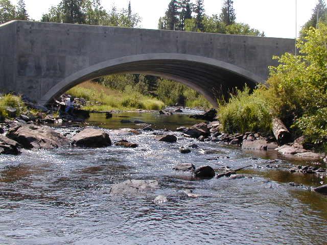
24 Residential Construction The lowest floor of residential structures must be elevated to prevent flood damage

25 Dead River Flooding, 2002
26 What s that?
27 Harmful interference means: Causing an increased stage or change in direction of flow that causes, or is likely to cause: 1. Damage to property 2. A threat to life 3. A threat of personal injury 4. Pollution, impairment, or destruction of water or other natural resources.

28 Water lapping at the door
29 High Velocities

30 Crystal Falls Dam, 2013

31 Part 31 Minor Projects Fill, grade changes or occupation of the floodway fringe Floodway Fringe

32 Part 31 Minor Projects Bridges Clear Span Lowest bottom of beam at or above the natural ground elevation on either bank approach fill sloping to natural ground elevations within 10 feet on either end of bridge Approach fill 10 or less Bridge Clear Spans Channel. Lowest bottom of beam at or above the natural ground

33 Clear Span Bridge Perch River-Baraga County P
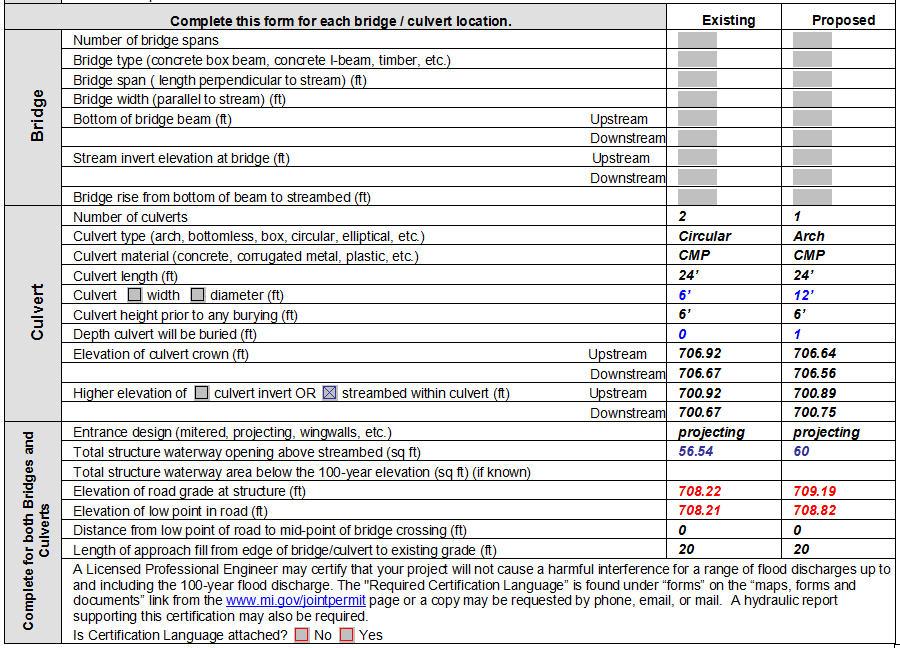
34 Part 31 Minor Projects Culverts Effective Waterway Opening that equals or exceeds the cross sectional area of the channel Not more than 1.5 feet of fill over culvert approach fill slopes to natural ground elevations within 10 feet of either side of the culvert Approach fill 10 or less 1.5 or Less Culvert recessed and equals or exceeds channel waterway area
35

36 Ontonagon County, 2002

37 Marquette County, 2002
38 Part 31 Exemptions* Watershed with a Drainage Area less than 2 square miles Bridge and culvert extensions up to 24 feet in length Bridge deck replacements and road resurfacing Some utility crossings Excavating where materials are placed in an upland area that is out of the floodplain * These projects may require other federal, state or local permits
39 Contact: Sheila Meier District Floodplain Engineer
40 Jim Watling Environmental Engineer
41 ... if there is any chance that your proposed structure would increase the flood elevations or water velocity compared to the existing conditions How do you know?
42


43


44 Flow Area Consider the flood water flowing through the structure and the water flowing around/over the structure. Weir flow is more efficient than flow through the structure.

45 Structural flow area If you are reducing the end area of the culvert or bridge then you will need to do a hydraulic analysis.

46 Changing the end area dimensions If you are changing the span or rise of the culvert or bridge then you may need to do a hydraulic analysis. Existing Proposed

47
48 Weir Flow If you are reducing weir flow (changing the low point in the road) a hydraulic analysis may be needed. You first need to determine if there is weir flow. Will all of the flow pass through the structure? Or will some of the flood flow pass over the road (weir flow)?


49
50 Friction losses Consider the surface that the water passes through or over. Going from metal to concrete will increase the friction loss. A hydraulic analysis will be required.
51 Will the length of the culvert change? - If you are replacing a culvert and increasing its length then a hydraulic analysis will be required - Exception: if you are extending an existing culvert/bridge by 24 feet or less then a hydraulic analysis is not required
52 Slope Are the proposed inverts different?

53


54 Is there a change in the entrance design? Headwalls (best), Mitered, Projecting (worse)
55 A reduction in flow area An change in road elevation A change in material type A change in slope A longer culvert or wider bridge A change in the entry type you may need to do a hydraulic analysis
56

57

58
59
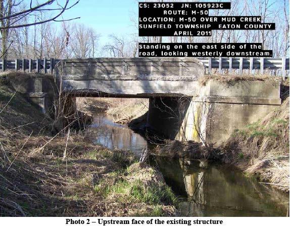
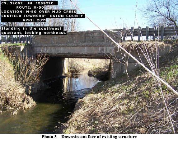
60 Jim Watling Transportation and Flood Hazard Unit Contact:
61 Hydraulic Design and Report You have determined that a hydraulic analysis is needed. What is the next step? Minmin Shu, Environmental Engineer
62 Confirm the site location Obtain the Design flow Field inspection and survey Preliminary design of road and structure* Conduct the hydraulic computation; refine the proposed design and hydraulic computation/modeling. Summarize the conditions and the findings into the hydraulic report.

63 Location Map Identify Site Location County, Township names Town/Range, Section Road name and stream name at the crossing Mark the flow direction USGS quad map is preferred
64 Submit a Discharge Request to the DEQ-HSU Turn around time approximately 30 days. You will be provided the drainage area and the flows you selected If the drainage area is under 2 square miles then a hydraulic analysis is not required under Part 31, although you still have the liability for your design.
65
66 Field Inspection and Survey Road profile Existing structure type and dimensions invert and low steel elevation, entrance type Average stream width at OHWM and bankfull width Obtain cross section(s) of the stream and overbank area HY-8: need 1 representative downstream cross section HEC-RAS: At least 2 cross sections upstream and 2 cross sections downstream
67 Field Inspection and Survey Continued Obtain distances between the cross sections and to your structure Existing structure dimensions Estimate the manning coefficient values for the channel and overbank areas. Field pictures

68 Field Pictures
69
70
71

72 Road at Structure Vicinity Area
73
74 Hydraulic Computation/Modeling Conduct the hydraulic computation for both existing and proposed conditions, up to and include 100 year flows. Compare the results, refine the proposed design if it is needed. Update the hydraulic computation/model to represent the final design.
75 Options for Hydraulic Calculations Hand Calculation Chart: Federal Highway Administration, Hydraulic Design of Culvert, Series No.5 HY8: Culvert Analysis. HEC-RAS, River Analysis System.

76 ics/pubs/12026/hif12026.pdf


77 See Handout HY-8 Version 7.2 Build Date January 17, 2012 HY-8 Version 7.3 Build Date August 18, 2014 Federal Highway Administration
 http://www.hec.")

78 HEC-RAS, River Analysis System To download HEC-RAS 4.1, go to the US Army Corps of Engineers web site. (Search HEC-RAS) See handout special PowerPoint presentation HEC-RAS: 10 Steps This presentation introduces you to the model and will help you get familiar with HEC-RAS.
79 Hydraulic Report Requirements Conduct your analysis comparing existing and proposed conditions. Submit your findingsbriefly discuss, method of analysis, assumptions, and conclusions
80 Engineer Certification and Affected Property Owner Statement If the hydraulic calculations show an increase in the energy grade line. elevation, one or both above documents are required to apply Part 31 permit.
81 - If the flood elevation increase is limited in the applicant s property, or the increase is beyond the applicant property but is below the stream bank, the design engineer (P.E.) must sign and submit a certification of no harmful interference. - Sample certification language can be found in Hydraulic Report Guidelines.
82 - If the flood elevation increase is 0.01 feet or greater, is over the bank and goes beyond the applicant s property, the design engineer (P.E.) must sign and submit a certification of no harmful interference. - In addition, copies of the Affected Property Owner Statement, must be sent to all property owners impacted by the proposed increase. - Sample statements can also be found at
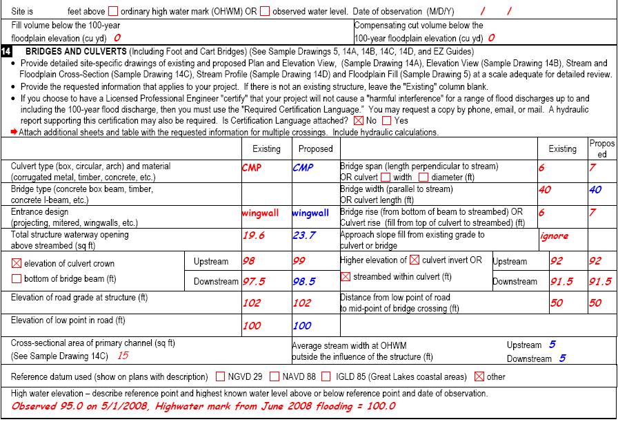
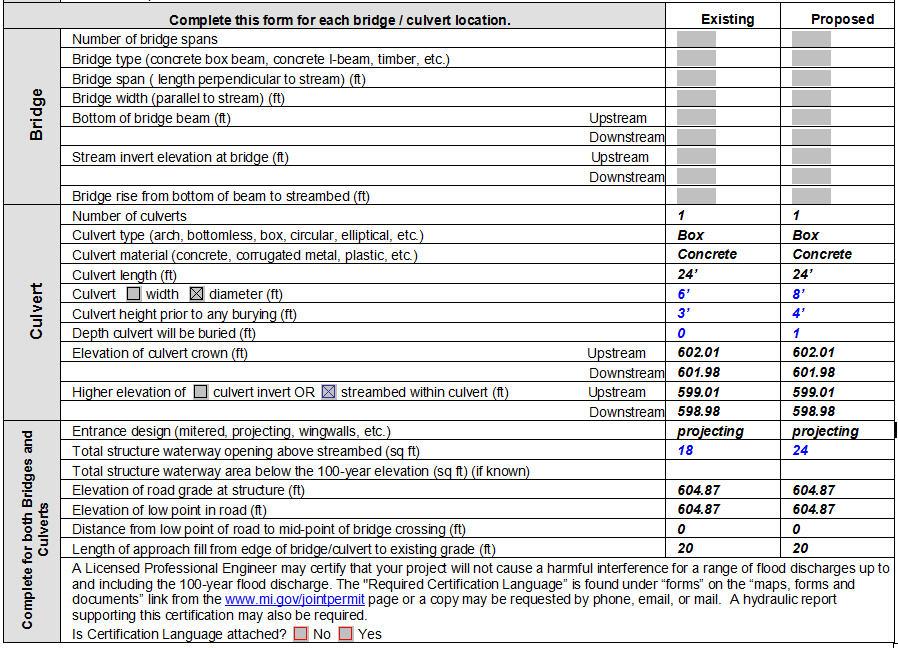
83 Final Document for Part 31 Permit Application For preliminary hydraulic review Electronic file of the computer model Hydraulic report For permit application Electronic file of the computer model Hydraulic report Fill out the permit application form, especially section 14 Engineer Certification and Affected Property Owner Statement if they are needed
84 Minmin Shu Transportation and Flood Hazard Unit Contact:
Hydraulic Report. County Road 595 Bridge over Dead River. Prepared By AECOM Brian A. Hintsala, P.E
 Prepared for: Prepared by: Marquette County Road Commission AECOM Ishpeming, MI Marquette, MI 60240279 December 9, 2011 Hydraulic Report County Road 595 Bridge over Dead River Prepared By AECOM Brian A.
Hydraulic Report. County Road 595 Bridge over Mulligan Creek. Prepared By AECOM Brian A. Hintsala, P.E
 Prepared for: Prepared by: Marquette County Road Commission AECOM Ishpeming, MI Marquette, MI 60240279 December 9. 2011 Hydraulic Report County Road 595 Bridge over Mulligan Creek Prepared By AECOM Brian
Prepared for: City of Jeffersonville. November Prepared by
 JEFFERSONVILLE STORMWATER MASTER PLAN HYDRAULICS APPENDIX JEFFERSONVILLE, INDIANA Prepared for: City of Jeffersonville November 2011 Prepared by Christopher B. Burke Engineering, Ltd. 115 W. Washington
Hydraulic Modeling with HY-8
 Hydraulic Modeling with HY-8 Linda Hansen PE, PWS MI Dept. of Environmental Quality Water Resources Division UP District Floodplain Engineer Today s Outline What is HY-8? Best Applications & Limitations
SECTION 11: REGULATORY FLOODWAYS
 SECTION 11: REGULATORY FLOODWAYS Contents 11.1. The Floodway... 11-2 11.1.1. The floodway concept... 11-2 11.1.2. Floodway map... 11-2 11.1.3. Floodway permitting... 11-3 11.1.4. Changing the floodway...
FEMA/USACE Coordination Plan
 FEMA/USACE Coordination Plan Project: Fargo-Moorhead Metropolitan Feasibility Study ND Diversion Channel with upstream staging Federal Plan (Authorized WRRDA 2014) Project Design: Project Reach: U.S. Army
Conceptual Design and Feasibility of a Natural Fishway at the Fremont BART Weir, Alameda Creek, California
 Conceptual Design and Feasibility of a Natural Fishway at the Fremont BART Weir, Alameda Creek, California Final Report September 2005 Prepared by Center for Ecosystem Management and Restoration, Oakland,
Appendix Q Draft Location Hydraulic Study Report For the State Route 32 Widening Between Fir Street and Yosemite Drive at Dead Horse Slough and South
 Appendix Q Draft Location Hydraulic Study Report For the State Route 32 Widening Between Fir Street and Yosemite Drive at Dead Horse Slough and South Fork Dead Horse Slough in the, California Draft Location
TABLE OF CONTENTS. 1.0 Background Watershed Description Hydrology - HEC-HMS Models Hydraulics - HEC-RAS Models...
 TABLE OF CONTENTS 1.0 Background... 1 2.0 Watershed Description... 1 3.0 Hydrology - HEC-HMS Models... 2 3.1 Hydrologic Approach... 2 3.2 Drainage Areas... 2 3.3 Curve Numbers... 2 3.4 Lag Times... 3 3.5
c. Effects of the Project on Public Health, Safety and the Environment
 INTRODUCTION a. Description of Proposed Activity This report is for the hydrologic and hydraulic analysis for the structure located at Sta.100+80.67 on S.R. 0978 in North Fayette Township, Allegheny County,
Development of a Stage-Discharge Rating for Site Van Bibber Creek at Route 93
 Development of a Stage-Discharge Rating for Site 330 - Van Bibber Creek at Route 93 Prepared for: Urban Drainage and Flood Control District 2480 W. 26 th Avenue Suite 156-B Denver, CO 80211 May 19, 2006
Technical Memorandum. Hydraulic Analysis Smith House Flood Stages. 1.0 Introduction
 Technical Memorandum Hydraulic Analysis Smith House Flood Stages 1.0 Introduction Pacific International Engineering (PIE) performed a hydraulic analysis to estimate the water surface elevations of the
Designing roads for fish, floods and foxes
 Designing roads for fish, floods and foxes Calculations 9 Swimming Plunging Flow & Leaping Occupied Velocity Prolonged > Capability Yes Swim in Burst Total Time in Burst Time to > Exhaustion Yes Barrier
Land and Water Management Division Programs. Department of Environmental Quality
 Land and Water Management Division Programs Department of Environmental Quality Land and Water Management Programs Since the mid-1970 s, special resources that exist at the interface between land and water
Will County Site Development Permit Submittal Checklist TAB 1 PROJECT OVERVIEW
 Applicant: Reviewer: Permit No.: The following tables contain a checklist of the requirements before a review for a Site Development Permit submittal will be accepted. Not all requirements pertain to every
Case Studies in Hazard Class Reductions Implementation of NY s Guidance for Dam Hazard Classification
 Case Studies in Hazard Class Reductions Implementation of NY s Guidance for Dam Hazard Classification Gregory J Daviero, PhD, PE, Principal Kevin Ruswick, PE, CFM, Associate May 2, 2014 Schnabel Engineering
Appendix B Stormwater Site Plan Submittal Requirements Checklist
 Stormwater Site Plan Submittal Requirements Checklist The Submittal Requirements Checklist is intended to aid the design engineer in preparing a Stormwater Site Plan. All items included in the following
Dawson County Public Works 25 Justice Way, Suite 2232, Dawsonville, GA (706) x 42228
 x 42228") Dawson County Public Works 25 Justice Way, Suite 2232, Dawsonville, GA 30534 (706) 344-3500 x 42228 DAWSON COUNTY STORM WATER REVIEW CHECKLIST Project Name: Property Address: Engineer: Fax #/Email: Date:
Dawson County Public Works 25 Justice Way, Suite 2232, Dawsonville, GA 30534 (706) 344-3500 x 42228 DAWSON COUNTY STORM WATER REVIEW CHECKLIST Project Name: Property Address: Engineer: Fax #/Email: Date:
Engineering Report Preliminary Floodplain Study. Executive Summary
 Executive Summary Engineering Report Preliminary Floodplain Study The Federal Emergency Management Agency (FEMA) has updated the Flood Insurance Rate Maps (FIRM) for Finney County, including the City of
Development of Stage-Discharge Ratings for Site 2240 Bear Creek at Cold Spring
 Development of Stage-Discharge Ratings for Site 2240 Bear Creek at Cold Spring Prepared for: Urban Drainage and Flood Control District 2480 W. 26 th Avenue Suite 156-B Denver, CO 80211 May 19, 2006 (Rev
S.R. 4031, SECTION FVR OVER BEAVER RUN SEGMENT 0170, OFFSET 6093 EAST NANTMEAL TOWNSHIP, CHESTER CO. ENGINEERING DISTRICT 6-0
 S.R. 4031, SECTION FVR OVER BEAVER RUN SEGMENT 0170, OFFSET 6093 EAST NANTMEAL TOWNSHIP, CHESTER CO. ENGINEERING DISTRICT 6-0 HYDROLOGIC & HYDRAULIC STUDY REPORT OCTOBER 2007 Prepared For: Prepared By:
New Castle County, DE. Floodplain Regulations
 New Castle County, DE Floodplain Regulations John J. Gysling, PE CFM Department of Land Use New Castle County, DE February 26, 2009 Today s Presentation Floodplain Protection and Uses Terms and Definitions
TECHNICAL GUIDANCE and CASE STUDY for INEFFECTIVE FLOW and CONVEYANCE SHADOW AREAS
 Utilities electric stormwater wastewater water 700 Wood St. PO Box 580 Fort Collins, CO 80522 970.221.6700 970.221.6619 fax 970.224.6003 TDD utilities@fcgov.com fcgov.com/utilities TECHNICAL GUIDANCE and
Regulatory Programs Administered by Indiana DNR, Division of Water presented by George Bowman
 Regulatory Programs Administered by Indiana DNR, Division of Water presented by George Bowman Presentation Overview Division of Water s role in DNR Regulatory Statutes and Rules Floodplain, Floodway, and
DRAFT. Jacob Torres, P.E.; Nick Fang, Ph.D., P.E.
 \ Memorandum SSPEED Center at Rice University Department of Civil & Environmental Engineering 6100 Main MS-317 Houston, Texas 77005-1827 sspeed.rice.edu tel: 713-348-4977 To Andy Yung, P.E. CFM; Lane Lease,
Upper Lightning Lake Water Level Management Environmental Assessment Worksheet. Attachment D Design Report for Upper Lightning Lake
 Upper Lightning Lake Water Level Management Environmental Assessment Worksheet Attachment D Design Report for Upper Lightning Lake DESIGN REPORT for Upper Lightning Lake Wetland Enhancement MN-332-2 I
Floodplain Special Review
 Larimer County Engineering Dept. Procedural Guide for: August 1, 2007 Floodplain Special Review Floodplain Special Review Process The floodplain special review process contains the following steps: 1.
2. DEFINITIONS. American Association of State Highway and Transportation Officials.
 2. DEFINITIONS 2.010 Definitions [See Amendment 2] In addition to words and terms that may be defined elsewhere in this manual, the following words and terms shall have the meanings defined below: AASHTO:
Programmatic General Permit Army Corps of Engineers Connecticut Addendum
 Programmatic General Permit Army Corps of Engineers Connecticut Addendum DEP USE ONLY NAE#: DEP #: PGP Screening Date: Determinations: Eligible Category 2 Eligible Category 1 Individual Permit Print or
CLAY STREET BRIDGE REPLACEMENT
 HYDROLOGY /HYDRAULICS REPORT. EL DORADO COUNTY CLAY STREET BRIDGE REPLACEMENT Prepared by: Joseph Domenichelli Domenichelli & Associates 1107 Investment Blvd., Suite 145 El Dorado Hills, California 95762
LOCATION AND DESIGN DIVISION
 VIRGINIA DEPARTMENT OF TRANSPORTATION LOCATION AND DESIGN DIVISION INSTRUCTIONAL AND INFORMATIONAL MEMORANDUM GENERAL SUBJECT: CULVERT DESIGN SPECIFIC SUBJECT: COUNTERSINKING AND LOW FLOW CONSIDERATIONS
UPRR criteria for sizing waterway openings under bridges and through culverts are as follows:
 UNION PACIFIC RAILROAD SCOPE OF HYDROLOGIC/HYDRAULIC DESIGN ENGINEERING AND PERMITTING SERVICES FOR SIZING WATERWAY OPENINGS AT NEW AND REPLACEMENT STRICTURES These flood passage criteria were developed
STREAMBANK RESTORATION DESIGN
 STREAMBANK RESTORATION DESIGN WITH VINYL SHEET PILE GRADE CONTROL STRUCTURES BRUCE M. PHILLIPS, M.S., P.E. ABSTRACT Grade control structures are an effective channel stabilization measure which can eliminate
S.R. 0944, Section 015 (Wertzville Road) Bridge over the West Branch of Simmons Creek. Silver Spring Township Cumberland County.
 Bridge over the West Branch of Simmons Creek. Silver Spring Township Cumberland County.") Hydrologic and Hydraulic Report For S.R. 0944, Section 015 (Wertzville Road) Bridge over the West Branch of Simmons Creek Silver Spring Township Cumberland County August 13, 2003 Prepared For Pennsylvania
Hydrologic and Hydraulic Report For S.R. 0944, Section 015 (Wertzville Road) Bridge over the West Branch of Simmons Creek Silver Spring Township Cumberland County August 13, 2003 Prepared For Pennsylvania
APPENDIX G DIVERSION AND PELICAN LAKE CUTOFF CHANNELS HYRAULICS AND BRIDGE TECHNICAL MEMORANDUM
 APPENDIX G DIVERSION AND PELICAN LAKE CUTOFF CHANNELS HYRAULICS AND BRIDGE TECHNICAL MEMORANDUM To: File Memo From: Matt Redington, P.E. Project: Watertown South Connector CC: Date: March 6, 2007; revised
Hackensack River Flood Reduction Study Update
 Township of River Vale Hackensack River Flood Reduction Study Update November 11, 2013 Purpose of Study To Analyze Where Frequent Flooding Is Impacting Property and How It Might Be Reduced Hackensack River
FLOODPLAIN PERMIT APPLICATION SUBMITTAL REQUIREMENTS
 Planning Department 215 South 4 th Street, Suite F Hamilton, MT 59840 Phone 406-375-6530 Fax 406-375-6531 planning@rc.mt.gov FLOODPLAIN PERMIT APPLICATION SUBMITTAL REQUIREMENTS To initiate the permit
Freight Street Development Strategy
 Freight Street Development Strategy Appendix B: Naugatuck River Floodplain Analysis Freight Street Development Strategy DECEMBER 2017 Page B-1 1.0 NAUGATUCK RIVER FLOODPLAIN AT FREIGHT STREET 1.1 Watershed
Chapter 11 Culverts and Bridges
 Chapter 11 Culverts and Bridges Contents 1.0 Introduction... 1 2.0 General Design... 1 2.1 Design Criteria... 1 2.2 Design Flows... 1 2.3 Permitting and Regulations... 1 2.4 Aesthetics and Safety... 2
APPLICATION FORM AF-50: CONSENT UNDER SECTION 50, ARTERIAL DRAINAGE ACT, 1945
 APPLICATION FORM AF-50: CONSENT UNDER SECTION 50, ARTERIAL DRAINAGE ACT, 1945 APPLICATION DETAILS Name of Applicant: Company / authority: Address: Date of Application: Client (if appropriate): BRIDGE DETAILS
Appendix D - Evaluation of Interim Solutions
 Appendix D - Evaluation of Interim Solutions D.1 Introduction The implementation of long-term improvements is projected to take 5 to 8 years. To reduce the number of years of flooding impacts, the partner
COON CREEK WATERSHED DISTRICT PERMIT REVIEW th Ave NE Ham Lake, MN 55304
 18-151 Meyer Garage, Page 1 of 5 COON CREEK WATERSHED DISTRICT PERMIT REVIEW MEETING DATE: January 28, 2019 AGENDA NUMBER: 9 FILE NUMBER: 18-151 ITEM: Meyer Garage RECOMMENDATION: Approve with 2 Stipulations
Outlet Structure Modeling
 Watershed Modeling using HEC-RAS Outlet Structure Modeling Jeff Wickenkamp, P.E., CFM, D.WRE Patrick Lach, P.E. Hey and Associates, Inc. Water Resources, Wetlands and Ecology Outline of Presentation Why
DRAINAGE SUBMITTAL CHECKLIST
 Project Name: Firm Name: Map ID: Engineer: Address: City: State: Zip: Phone Number: Fax Number: Property Owner: Address: City: State: Zip: Reviewed By: Date Received: Date Accepted for Review: The following
CITY OF WAXAHACHIE, TEXAS MANUAL FOR THE DESIGN OF STORM DRAINAGE SYSTEMS
 CITY OF WAXAHACHIE, TEXAS MANUAL FOR THE DESIGN OF STORM DRAINAGE SYSTEMS MAY, 2001 TABLE OF CONTENTS Page No. SECTION I: INTRODUCTION 1.1 General... I-1 1.2 Scope... I-1 1.3 Organization of Manual...
CONSTRUCTION PLAN CHECKLIST
 CONSTRUCTION PLAN CHECKLIST The design engineer is responsible for ensuring that plans submitted for city review are in accordance with this checklist. It is requested that the executed checklist be submitted
Pajaro River Watershed Flood Prevention Authority. Phase 3 and 4a. Pajaro River Watershed Study
 Pajaro River Watershed Flood Prevention Authority Phase 3 and 4a FEBRUARY 2005 Funding for this project has been provided in full or in part through a contract with the SWRCB pursuant to the Costa-Machado
Cherokee County Future Conditions Floodplain Development
 TECHNICAL MEMORANDUM Cherokee County Future Conditions Floodplain Development Prepared for: Prepared by: Geoff Morton, P.E., County Engineer Cherokee County Richard Greuel, P.E.,, Inc. Richard Taylor,
TABLE OF CONTENTS PART III - MINIMUM DESIGN STANDARDS Section 105 DRAINAGE SYSTEM DESIGN SPECIFICATIONS AND SCOPE 105.1
 TABLE OF CONTENTS PART III - MINIMUM DESIGN STANDARDS Section 105 DRAINAGE SYSTEM DESIGN SECTION TITLE PAGE 105.1. SPECIFICATIONS AND SCOPE 105.1 105.2. METHODS OF ANALYSIS 105.1 105.2.1. Rational Method
CUYAHOGA COUNTY ENGINEER
 CUYAHOGA COUNTY ENGINEER DRAINAGE MANUAL Supplement to O.D.O.T. LOCATION and DESIGN MANUAL, Volume 2, Drainage Design, Section 1000 and 1100 May 28, 2010 Revisions to the July 29, 2009 edition are noted
COMMONWEALTH OF PENNSYLVANIA DEPARTMENT OF ENVIRONMENTAL PROTECTION
 COMMONWEALTH OF PENNSYLVANIA DEPARTMENT OF ENVIRONMENTAL PROTECTION PERMIT GUIDELINES FOR PHASED NPDES STORMWATER DISCHARGES ASSOCIATED WITH CONSTRUCTION ACTIVITY PERMITS, CHAPTER 102 EROSION AND SEDIMENT
Temporary Watercourse Crossing: Culverts
 Temporary Watercourse Crossing: Culverts DRAINAGE CONTROL TECHNIQUE Low Gradient Velocity Control Short Term Steep Gradient Channel Lining Medium-Long Term Outlet Control Soil Treatment Permanent Symbol
Modeling a Complex Hydraulic Environment Using a 1-D Approach Supplemented with Simple 2-D Principles Manas Borah Ed Dickson June 5, 2014
 ASFPM 2014 Annual Conference Modeling a Complex Hydraulic Environment Using a 1-D Approach Supplemented with Simple 2-D Principles Manas Borah Ed Dickson June 5, 2014 Agenda Overview and Background Hydrology
Appendix J Hydrology and Hydraulics
 Appendix J Hydrology and Hydraulics Marsh Lake Dam Ecosystems Restoration Feasibility Study Hydraulics & Hydrology Appendix January 2011 Contents List of Figures iii List of Tables iii I. General 1 II.
Stormwater Management Studies PDS Engineering Services Division ES Policy # 3-01
 Stormwater Management Studies PDS Engineering Services Division Revised Date: 2/28/08 INTRODUCTION The City of Overland Park requires submission of a stormwater management study as part of the development
Calapooia River Fish Passage Analysis and Culvert Removal Proposal
 Calapooia River Fish Passage Analysis and Culvert Removal Proposal Submitted to: Calapooia Watershed Council P.O. Box 844 Brownsville, OR 97327 Prepared by: Oregon State University Department of Biological
KANKAKEE COUNTY PLANNING DEPARTMENT APPLICATION FOR CLASS I & II GRADING AND DRAINAGE/STOMRWATER PERMIT APPLICATION
 KANKAKEE COUNTY PLANNING DEPARTMENT APPLICATION FOR CLASS I & II GRADING AND DRAINAGE/STOMRWATER PERMIT APPLICATION Michael J. Van Mill, AICP Planning Director 189 East Court Street Kankakee, IL 60901
ODOT Floodplain Management. Jeffrey Syar, P.E., Administrator, Central Office,Hydraulic Engineering
 ODOT Floodplain Management Jeffrey Syar, P.E., Administrator, Central Office,Hydraulic Engineering John R. Kasich, Ohio Governor Jerry Wray, ODOT Director Background NFIP Ohio Department of Natural Resource
VII - WATER CONTROL PLAN
 VII - WATER CONTROL PLAN 7-01. General Objectives. Regulation of Saylorville Lake in conjunction with Lake Red Rock provides flood control benefits along both the Des Moines and Mississippi Rivers. Additionally,
Storm Water System Improvements
 IV Storm Water System Improvements A. General The purpose of this Section is to establish standard principles and practices for the design and construction of storm drainage facilities within the City
Hydrology and Flooding
 Hydrology and Flooding Background The 1996 flood Between February 4, 1996 and February 9, 1996 the Nehalem reporting station received 28.9 inches of rain. Approximately 14 inches fell in one 48 hour period.
State of Vermont Culvert sizing based on the Stream Alteration General Permit
 State of Vermont Culvert sizing based on the Stream Alteration General Permit Northeastern Transportation and Wildlife Conference September 11, 2018 Todd Menees, PE River Management Engineer VT DEC Rivers
SUMMARY OF BACKGROUND INFORMATION REVIEWED
 TO: FROM: Mark Lobermeier, PE Ismael Martinez, PE Brad Woznak, PE, PH, CFM Tim Diedrich, PE DATE: RE: Kinni Corridor Plan - Hydrologic & Hydraulic Analysis Summary SEH No. RIVER 138553 14.00 This draft
NEW CASTLE CONSERVATION DISTRICT. through. (Name of Municipality) PLAN REVIEW APPLICATION DRAINAGE, STORMWATER MANAGEMENT, EROSION & SEDIMENT CONTROL
 PLAN REVIEW APPLICATION DRAINAGE, STORMWATER MANAGEMENT, EROSION & SEDIMENT CONTROL") NEW CASTLE CONSERVATION DISTRICT through (Name of Municipality) PLAN REVIEW APPLICATION DRAINAGE, STORMWATER MANAGEMENT, EROSION & SEDIMENT CONTROL Office use only: Received by Municipality: Received by
NEW CASTLE CONSERVATION DISTRICT through (Name of Municipality) PLAN REVIEW APPLICATION DRAINAGE, STORMWATER MANAGEMENT, EROSION & SEDIMENT CONTROL Office use only: Received by Municipality: Received by
MODEL Stormwater Local Design Manual. City of Centerville
 MODEL Stormwater Local Design Manual City of Centerville Adopted December 6, 2005 TABLE OF CONTENTS 1. FORWARD... 1 2. GENERAL LEVEL OF SERVICE STANDARDS... 1 2.1. DETENTION REQUIREMENTS... 1 2.1.1. Discharge
Little Bear Brook Flood Hazard Assessment and Redevelopment Area Regional Stormwater Management Analysis. Progress Meeting
 Little Bear Brook Flood Hazard Assessment and Redevelopment Area Regional Stormwater Management Analysis Progress Meeting June 30, 2014 Princeton Hydro, LLC and SWM Consulting, LLC Project Team West Windsor
Project Summary: - Hydrologic Models. - LiDAR Based - 10 Synthetic Events - No Historic Events - 100yr Runoff is Largest - Assumes Even Rainfall
 Project Summary: - Hydrologic Models Phase 2 Underway Nearly Completed (Park/Pembina EOY) - LiDAR Based - 10 Synthetic Events - No Historic Events - 100yr Runoff is Largest - Assumes Even Rainfall Phase
INFLOW DESIGN FLOOD CONTROL SYSTEM PLAN 40 C.F.R. PART PLANT YATES ASH POND 3 (AP-3) GEORGIA POWER COMPANY
 GEORGIA POWER COMPANY") INFLOW DESIGN FLOOD CONTROL SYSTEM PLAN 40 C.F.R. PART 257.82 PLANT YATES ASH POND 3 (AP-3) GEORGIA POWER COMPANY EPA s Disposal of Coal Combustion Residuals from Electric Utilities Final Rule (40 C.F.R.
INFLOW DESIGN FLOOD CONTROL SYSTEM PLAN 40 C.F.R. PART 257.82 PLANT YATES ASH POND 3 (AP-3) GEORGIA POWER COMPANY EPA s Disposal of Coal Combustion Residuals from Electric Utilities Final Rule (40 C.F.R.
The Beckett s Run Experience. Fort Wayne, Indiana
 The Beckett s Run Experience Fort Wayne, Indiana Introductions Charlie Cochran City of Fort Wayne, Wet Weather Storm & Sewer Engineering Jason Durr, PE Christopher B. Burke Engineering, LLC 2 A Little
SECTION IV WATERSHED TECHNICAL ANALYSIS
 A. Watershed Modeling SECTION IV WATERSHED TECHNICAL ANALYSIS An initial step in the preparation of this stormwater management plan was the selection of a stormwater simulation model to be utilized. It
COON CREEK WATERSHED DISTRICT PERMIT REVIEW. Spring Lake Park Schools Westwood Middle School st Avenue NE, Spring Lake Park, MN 55432
 PAN 16-112, Westwood Middle School, Page 1 of 6 COON CREEK WATERSHED DISTRICT PERMIT REVIEW MEETING DATE: August 22, 2016 AGENDA NUMBER: 10 FILE NUMBER: 16-112 ITEM: Westwood Middle School RECOMMENDATION:
3.3 Acceptable Downstream Conditions
 iswm TM Criteria Manual - = Not typically used or able to meet design criterion. 1 = The application and performance of proprietary commercial devices and systems must be provided by the manufacturer and
Bridge Replacement Project. Preliminary Hydraulic Study. Lincoln, California BRLS-5089 (021) BRIDGE 19C Mcbean Park Drive at Auburn Ravine
 BRIDGE 19C Mcbean Park Drive at Auburn Ravine") Bridge Replacement Project Preliminary Hydraulic Study Lincoln, California BRLS-5089 (021) BRIDGE 19C 0059 Mcbean Park Drive at Auburn Ravine Prepared By: Prepared By: Date 11/25/2014 Thomas S. Plummer
Bridge Replacement Project Preliminary Hydraulic Study Lincoln, California BRLS-5089 (021) BRIDGE 19C 0059 Mcbean Park Drive at Auburn Ravine Prepared By: Prepared By: Date 11/25/2014 Thomas S. Plummer
Project Drainage Report
 Design Manual Chapter 2 - Stormwater 2A - General Information 2A-4 Project Drainage Report A. Purpose The purpose of the project drainage report is to identify and propose specific solutions to stormwater
Stormwater Local Design Manual For Houston County, Georgia
 Stormwater Local Design Manual For Houston County, Georgia Adopted November 15, 2005 TABLE OF CONTENTS 1. FORWARD... 1 2. GENERAL LEVEL OF SERVICE STANDARDS... 2 2.1. DETENTION REQUIREMENTS... 2 2.1.1.
Ordinance No Lot Surface Drainage
 Ordinance No. 35-2008 - Lot Surface Drainage The Township has adopted a new Lot Surface Drainage Ordinance which amends Chapter 170, Article IX, Subdivision and Site Plan Review by adding a new Section
Section H Project Description Narrative
 Section H Project Description Narrative Permit No. Pennsylvania Department of Transportation, Engineering District 2-0, 1924 Daisy Street Extension, P.O. Box 342, Clearfield, PA 16830 S.R. 2004, Section
Cokato Lake (86-263) Wright County. Hydrologic Investigation
 Wright County. Hydrologic Investigation") Cokato Lake (86-263) Wright County Hydrologic Investigation April 14, 2005 Cokato Lake (86-263) Wright County Hydrologic Investigation April 14, 2005 Problem Statement In recent years, heavy rainfall has
Cokato Lake (86-263) Wright County Hydrologic Investigation April 14, 2005 Cokato Lake (86-263) Wright County Hydrologic Investigation April 14, 2005 Problem Statement In recent years, heavy rainfall has
Section 6: Stormwater Improvements
 Section 6: Stormwater Improvements A major objective of this study was to identify opportunities for improvements to address the widespread water quality impairments caused by stormwater runoff in the
FLOOD MAGNITUDE AND FREQUENCY OF LITTLE TIMBER CREEK AT THE CULVERT ON INTERSTATE ROUTE 295 IN HADDON HEIGHTS TOWNSHIP, CAMDEN COUNTY, NEW JERSEY
 FLOOD MAGNITUDE AND FREQUENCY OF LITTLE TIMBER CREEK AT THE CULVERT ON INTERSTATE ROUTE 295 IN HADDON HEIGHTS TOWNSHIP, CAMDEN COUNTY, NEW JERSEY U.S. GEOLOGICAL SURVEY Open-File Report 96-321 Prepared
Chapter 44 FLOOD HAZARD AREA DEVELOPMENT REGULATIONS
 Chapter 44 FLOOD HAZARD AREA DEVELOPMENT REGULATIONS 44.01 Authority and Purpose 44.02 Definitions 44.03 Enforcement Procedure 44.04 Duties of the Enforcement Official 44.05 Base Flood Elevation 44.06
DESIGN DOCUMENTATION REPORT APPENDIX C HYDROLOGY AND HYDRAULICS
 January 8, 2016 WP-42I FINAL SUBMITTAL DESIGN DOCUMENTATION REPORT APPENDIX C HYDROLOGY AND HYDRAULICS Fargo-Moorhead Flood Risk Management Project In-Town Levees Mickelson Levee Extension WP-42I Engineering
PRENTISS CREEK (SUB-E) KENSINGTON PLACE CONCEPT PLAN VILLAGE OF DOWNERS GROVE, ILLINOIS AUGUST, 2011
 KENSINGTON PLACE CONCEPT PLAN VILLAGE OF DOWNERS GROVE, ILLINOIS AUGUST, 2011") PRENTISS CREEK (SUB-E) KENSINGTON PLACE CONCEPT PLAN VILLAGE OF DOWNERS GROVE, ILLINOIS AUGUST, 2011 Submitted to: NATHANIEL HAWK, STAFF ENGINEER VILLAGE OF DOWNERS GROVE 5101 WALNUT AVENUE DOWNERS GROVE,
PRENTISS CREEK (SUB-E) KENSINGTON PLACE CONCEPT PLAN VILLAGE OF DOWNERS GROVE, ILLINOIS AUGUST, 2011 Submitted to: NATHANIEL HAWK, STAFF ENGINEER VILLAGE OF DOWNERS GROVE 5101 WALNUT AVENUE DOWNERS GROVE,
LAKE COUNTY HYDROLOGY DESIGN STANDARDS
 LAKE COUNTY HYDROLOGY DESIGN STANDARDS Lake County Department of Public Works Water Resources Division 255 N. Forbes Street Lakeport, CA 95453 (707)263-2341 Adopted June 22, 1999 These Standards provide
OFFICE OF STRUCTURES MANUAL ON HYDROLOGIC AND HYDRAULIC DESIGN CHAPTER 3 POLICY AND PROCEDURES
 OFFICE OF STRUCTURES MANUAL ON HYDROLOGIC AND HYDRAULIC DESIGN CHAPTER 3 POLICY AND PROCEDURES April 28, 2016 Table of Contents 3.1 Introduction... 2 3.1.1 Purpose of Chapter 3... 2 3.1.2 Policy vs. Design
Green Station CCR Surface Impoundment
 Green Station CCR Surface Impoundment Disposal of Coal Combustion Residuals (CCR) from Electric Utilities Final Rule Hydrologic and Hydraulic Capacity Assessment and Initial Inflow Design Flood Control
REQUIREMENT FOR FLOODPLAIN AND FLOODWAY DELINEATION IN RIVERINE ENVIRONMENTS
 ARIZONA DEPARTMENT OF WATER RESOURCES FLOOD MITIGATION SECTION REQUIREMENT FOR FLOODPLAIN AND FLOODWAY DELINEATION IN RIVERINE ENVIRONMENTS The Director of the Arizona Department of Water Resources under
Hydrotechnical Design Guidelines for Stream Crossings
 Hydrotechnical Design Guidelines for Stream Crossings Introduction Design of stream crossings and other in-stream highway facilities requires estimation of design highwater elevation and mean channel velocity.
STORM DRAINAGE DESIGN MANUAL
 Appendix I STORM DRAINAGE DESIGN MANUAL by: SUNGATE DESIGN GROUP, P.A. GEN ERAL DESIGN STAN DARDS AN D POLICIES 1. STREET AND LOCAL DRAINAGE Discharge estimates for specified design storms shall be calculated
(b) The written request must include 5 components: 1 The Permit Review and Approval Process. (1) Step 1: Pre-Coordination.
 The written request must include 5 components: 1 The Permit Review and Approval Process. (1) Step 1: Pre-Coordination.") 1 The Permit Review and Approval Process The processing of a Section 408 Permit request begins with a written request from an applicant. Along with the written request, a permit application (attached)
1 The Permit Review and Approval Process The processing of a Section 408 Permit request begins with a written request from an applicant. Along with the written request, a permit application (attached)
Kentucky Division of Water Floodplain Permit Review Overview and Considerations
 YouTube Video Kentucky Division of Water Floodplain Permit Review Overview and Considerations Presentation to: 2016 KAMM Conference KY Dam Village State Resort Park by Solitha W. Dharman Department for
MINNESOTA DEPARTMENT OF TRANSPORTATION BRIDGE SCOUR EVALUATION PROCEDURE FOR MINNESOTA BRIDGES
 MINNESOTA DEPARTMENT OF TRANSPORTATION BRIDGE SCOUR EVALUATION PROCEDURE FOR MINNESOTA BRIDGES December 2009 Introduction This document describes the policy of the Minnesota Department of Transportation
RE: Recommendations for Staged Implementation of Alternative 3a
 March 10, 2006 Ms. Julie Thomas Coastal San Luis Resource Conservation District 545 Main Street, Suite B-1 Morry Bay, Ca 93442 RE: Recommendations for Staged Implementation of Alternative 3a Dear Ms. Thomas,
Urban Study. Rocky Branch Watershed Columbia, South Carolina. June 1, Project No
 Urban Study Rocky Branch Watershed Columbia, South Carolina Prepared for: City of Columbia 1136 Washington Street Columbia, SC 29217 Prepared by: AMEC Environment & Infrastructure, Inc. 720 Gracern Road
CHAPTER 6 ADDITIONAL STANDARDS APPLYING TO SHORELAND AREAS AND PUBLIC WATERS
 CHAPTER 6 ADDITIONAL STANDARDS APPLYING TO SHORELAND AREAS AND PUBLIC WATERS Section 1 Intent. 49 Section 2 Floodplain Requirements 49 Section 3 Water-Oriented Accessory Structures 50 Section 4 Stairways,
Beaver Brook Flood Study
 Alternatives Analysis Beaver Brook Flood Study Pelham, New Hampshire PREPARED FOR Town of Pelham 6 Village Green Pelham, NH 03076 PREPARED BY 101 Walnut Street PO Box 9151 Watertown, MA 02471 617.924.1770
JOINT PUBLIC NOTICE. January 16, Post Office Box Post Office Box 4313 New Orleans, Louisiana Baton Rouge, Louisiana
 JOINT PUBLIC NOTICE January, United States Army Corps of Engineers State of Louisiana New Orleans District Department of Environmental Quality Regulatory Branch Office of Environmental Services Post Office
Natural Channel Design and Dead River Case Study Stream Restoration in the Great Lakes Basin: Using In-stream Structures & Natural Channel Design
 Natural Channel Design and Dead River Case Study Stream Restoration in the Great Lakes Basin: Using In-stream Structures & Natural Channel Design January 22, 2013 S. Paige Baker, PE, MLE Presentation Outline