Seepage Loss Test Results in Cameron County Irrigation District No. 2
|
|
|
- Jack Perkins
- 5 years ago
- Views:
Transcription


1 COLLEGE OF AGRICULTURE AND LIFE SCIENCES TR Seepage Loss Test Results in Cameron County Irrigation District No. 2 By: Eric Leigh, Extension Associate and Guy Fipps, P.E., Extension Agricultural Engineer Department of Biological and Agricultural Engineering, Texas A&M University, College Station, TX. Prepared for: Cameron County Irrigation District No. 2 April 2011 Texas Water Resources Institute Technical Report No. 375 Texas A&M University System College Station, Texas
2 TR TWRI SEEPAGE LOSS TEST RESULTS IN CAMERON COUNTY IRRIGATION DISTRICT NO.2 Rio Grande Basin Initiative Irrigation Technology Center Texas Water Resources Institute Texas AgriLife Extension Service
3 Seepage Loss Test Results In Cameron County Irrigation District No. 2 1 Report Prepared for Cameron County Irrigation District No. 2 by Eric Leigh and Guy Fipps, P.E. 2 December 18, A portion of this study was funded by Texas Cooperative Extension through the Rio Grande Basin Initiative administered by the Texas Water Resources Institute of the Texas A&M University System with funds provided through a grant from Cooperative State Research, Education, and Extension Service, U.S. Department of Agriculture, under Agreement No Extension Associate, and Professor and Extension Agricultural Engineer, respectively, Biological and Agricultural Engineering, 2117 Texas A&M University, College Station, TX
 on five canal segments located as shown on the right. The results are summarized in Table 1 for the 5 tests conducted during Summer 2002 and a test performed previously in the district.")
4 2 Seepage Loss Test Results In Cameron County Irrigation District No. 2 Summary This report summarizes seepage loss tests conducted in Cameron County Irrigation District No. 2 (CCID2) on five canal segments located as shown on the right. The results are summarized in Table 1 for the 5 tests conducted during Summer 2002 and a test performed previously in the district. The locations of these tests are shown in more detailed on the attached map. Canals 23, 27, 33 and 35 are unlined canals supplied by main canal B. These canals run from main canal B east crossing Center Line Road and Brown Tract Road. Canal 55 is an unlined canal located 5 miles due north from canal 35 off of Brown Tract Road. Maximum operating depths range from 3 to 5 ft. Typically in this region, the normal operating depth is about 6 inches to a foot of the maximum. Table 1: Seepage Loss Test Results for the project area described above of CCID2. All segments are earth-lined. Test # Segment Soil Type 1 Canal 23 fine sandy clay loam Top Width (ft) Length (ft) Ave Loss Seepage Rate (gal/ft 2 /day) Total Loss in Canal (ac-ft/mile) per day per year Canal 27 clay loam Canal 33 4 Canal 35 fine sandy clay loam fine sandy clay loam Canal 55 clay loam **RM 1 Canal 29 clay loam ** Corrected test calculations for RM-1 (Region M Study see This test is not discussed further in this report.
, as are any valves or gates located in the test segment. Changes in water levels are recorded for at least 48 hours. One to three continuous-stage level recorders (Fig.")
5 3 TEST METHOD Loss rates were determined using the ponding method. In this method, the two ends of a canal segment are closed or sealed with earthen dams (Fig. 1), as are any valves or gates located in the test segment. Changes in water levels are recorded for at least 48 hours. One to three continuous-stage level recorders (Fig. 2) were used to supplement the 3 locations where stage levels were recorded manually. During the tests, canal dimensions and water span were also record and surveyed. Figure 1. Earthen dam constructed on canal 55.
 sample was from inside the canal at or below the normal opporating water level, and the other at a location approximately 10 ft from the edge of the canal and 2 feet")
6 4 Soil Sampling and Groundwater Level Measurement Two soil samples were taken of the canal embankment (or levee) and one in a field adjacent to the canal. One canal embankment (levee) sample was from inside the canal at or below the normal opporating water level, and the other at a location approximately 10 ft from the edge of the canal and 2 feet below the surface. Natural surrounding soil samples were taken in fields adjacent to the test area down to 12 foot of depth. In these tests, shallow groundwater was not found within 12 feet of the soil surface. Figure 2. Continuous-stage level recorders on canal 55.

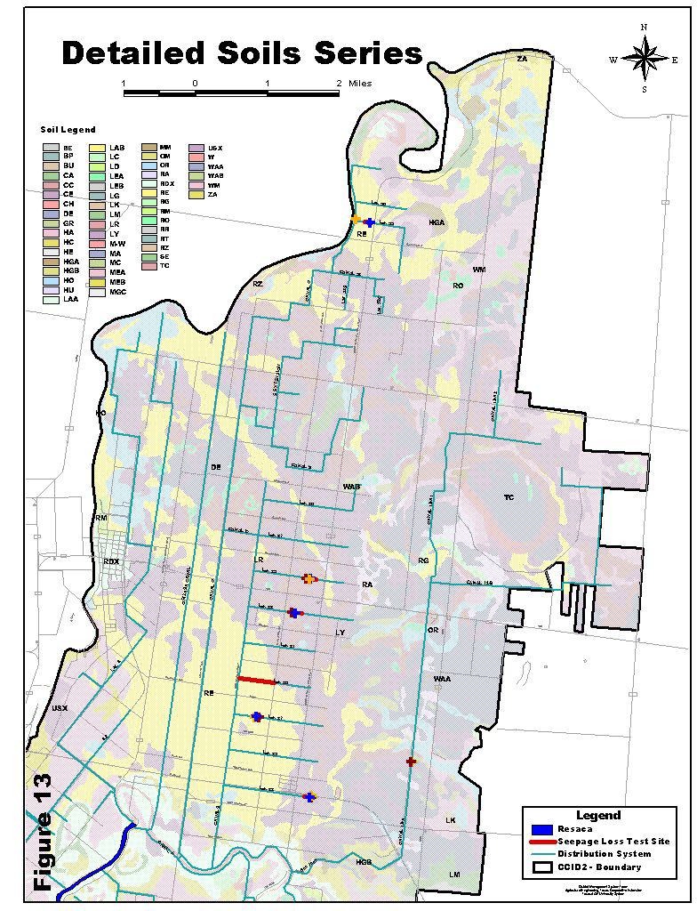
7 Figure 3 Test site location. 5
8 6 DETAILED TEST RESULTS Tables 4 11 provide additional details on the test results and other information collected. For each canal, two tables are provided. The first table gives canal dimensions, testing dates and time, and stage level measurements. The second table gives the loss rated in 5 methods commonly used to characterize water loss in canals. Note: annual water loss rates assume that the canal is in service 365 days per year. For each test segment, a chart is provided showing the measured canal profile compared to the expected canal profile. The expected profile was developed by fitting an equation to the measured data as shown. Table 2. Test Information for Canal 23 District: Cameron County Irrigation District 2 Test ID: Canal 23 Canal: Canal 23 Lining Type: Earth Top Width: 20 ft Date: June 18 20, 2002 Test Length: 640 ft Start Time: 18:51 Total Depth: 3.5 ft Finish Time: 14:01 Location: East of Brown Tract Rd, end of section. Staff Gage Readings SG1 SG2 SG3 Date Reading Time Reading Time Reading Time 1 18-Jun : : : Jun : : : : : : : : : Jun : : : : : :01 Table 3. Average Unit Area Loss Rate for Canal 23. ft 3 /ft 2 /hour ft/day inches/day gal/ft 2 /day acre-ft/mile/year avg. std. dev. avg. std. dev

9 7 Canal 23 7 y = x x 6 5 feet feet measured expected Figure 4. Cross-section of canal 23. Figure 5. Canal 23
10 8 Table 4. Test Information for Canal 27 District: Cameron County Irrigation District 2 Test ID: Canal 27 Canal: Canal 27 Lining Type: Earth Top Width: 16 ft Date: June 5 7, 2002 Test Length: 600 ft Start Time: 15:03 Total Depth: 2.5 ft Finish Time: 09:26 Location: East of Canal B and west of Center Line Rd. Staff Gage Readings SG1 SG2 SG3 SG4 SG5 Date Reading Time Reading Time Reading Time Reading Time Reading Time 1 5-Jun : : : : : : : : : : Jun : : : : : : : : : : : : : : : : : : : : Jun : : : : :24 Canal y = x x feet measured expected Figure 6. Cross-section of canal 27. Table 5. Average Unit Area Loss Rate for Canal 27. ft 3 /ft 2 /hour ft/day inches/day gal/ft 2 /day acre-ft/mile/year avg. std. dev. avg. std. dev
11 9 Table 6. Test Information for Canal 33 District: Cameron County Irrigation District 2 Test ID: Canal 33 Canal: Canal 33 Lining Type: Earth Top Width: 18 ft Date: June 5 7, 2002 Test Length: 740 ft Start Time: 17:01 Total Depth: 5 ft Finish Time: 10:45 Location: East of Center Line Rd. and west of Brown Tract Rd. South of 106. Staff Gage Readings SG1 SG2 SG3 Date Readings Time Readings Time Readings Time 1 5-Jun : : : Jun : : : : : : : : : Jun : : :45 Canal 33 y = x x feet measured expected Figure 7. Cross-section for canal 33 Table 7. Average Unit Area Loss Rate for Canal 33. ft 3 /ft 2 /hour ft/day inches/day gal/ft 2 /day acre-ft/mile/year avg. std. dev. avg. std. dev
12 10 Table 8. Test Information for Canal 35 District: Cameron County Irrigation District 2 Test ID: Canal 35 Canal: Canal 35 Lining Type: Earth Top Width: 17 ft Date: June 19 21, 2002 Test Length: 600 ft Start Time: 19:22 Total Depth: 3.5 ft Finish Time: 09:36 Location: East of Center Line Rd. and west of Brown Tract Rd. North of 106. Staff Gage Readings SG1 SG2 SG3 Date Readings Time Readings Time Readings Time 1 19-Jun : : : Jun : : : : : : : : : : : : : : : Jun : : :36 Canal 35 7 y = x x feet measured expected Figure 8. Cross-section of canal 35

13 11 Table 9. Average Unit Area Loss Rate for Canal 35. gal/ft 2 /day acre-ft/mile/year ft 3 /ft 2 /hour ft/day inches/day avg. std. dev. avg. std. dev Figure 9. Canal 35
14 12 Table 10. Test Information for Canal 55 District: Cameron County Irrigation District 2 Test ID: Canal 55 Canal: Canal 55 Lining Type: Earth Top Width: 18.5 ft Date: August 7, 2002 Test Length: 500 ft Start Time: 09:52 Total Depth: 4.5 ft Finish Time: 15:16 Location: West of Brown Tract Rd. and north of Johnson Rd. Staff Gage Readings Date Readings Time 1 7-Aug : : : :16 Canal 55 y = x 2 + 1E-05x feet measured expected Figure 10. Cross-section of canal 55

15 13 Figure 11. Canal 55 Table 11. Average Unit Area Loss Rate for canal 55. ft 3 /ft 2 /hour ft/day inches/day gal/ft 2 /day acre-ft/mile/year
16 14 Literature Review Very little information has been reported in scientific literature on canal seepage and reduction from district rehabilitation projects. All the data that we have found for seepage rates versus lining type are given in Tables 12 and 13. Table 12. Canal seepage rate reported in published studies. Lining/soil type Seepage rate (gal/ft 2 /day) Unlined Portland cement Compacted earth Brick masonry lined Earthen unlined Concrete Plactic Concrete Gunite Compacted earth Clay Loam Sand DeMaggio (1990). 2 U.S. Bureau of Reclamation (1963). 3 Nayak, et al. (1996). 4 Nofziger (1979). Table 13. Canal seepage rates reported for the Lower Rio Grande Valley. Soil Type Seepage Loss Rate (gal/ft 2 /day) clay 1.5 silty clay loam 2.24 clay loam 2.99 silt loam earth 4.49 loam 7.48 fine sandy loam 9.35 Sandy loam Source: Texas Board of Water Engineers (1946).

17 15 Soil Descriptions 3 General Soil Series 7 Lyford-Raymondville-Lozano association: Nearly level, well drained and moderately well drained sandy clay loams, clay loams, and fine sandy loams. 9 Willacy-Raymondville association: Nearly level to gently sloping, well drained and moderately well drained sandy loams and clay loams. 13 Mercedes association: Level to gently sloping, moderately well drained clays. Table 14: Detailed Soil Units / Permeability Soil Unit 4 Permeability In\hr RE Raymondville clay loam LY Lyford sandy clay loam LR Lozano fine sandy loam Figure 12. Canal levee soil profile on canal Soil Surveys of Cameron County, USDA, SCS, TAES (1979) 4 See Detailed Soil Map (Figure 13).
18 16
19 17 Acknowledgements DMS TEAM Support provided by the DMS (District Management System) team of: Martin Barroso, Extension Agricultural Technician Noemi Perez, Extension Agricultural Technician Gabriel Ortega, Extension Assistant Bryan Treese, Extension Assistant (former) Daniel Wishard, Student Worker Brock Faulkner, Student Worker CAMERON COUNTY IRRIGATION DISTRICT NO.2 Helpful planning and assistance in canal ponding tests was provided by the District office and field personnel, and canal riders. References DeMaggio, J Technical Memorandum: San Luis unit drainage program project files. U.S. Bureau of Reclamation, Sacramento, CA. U.S. Bureau of Reclamation Lining for Irrigation Canals. Nayak, S., B.C. Sahoo, P.K. Mohapatra, and G.P. Pattanaik Profit potential of lining watercourses in coastal commands of Orissa. Environment & Ecolgy, 14(2): Nofziger, D.L The influence of canal seepage on groundwater in Lugert Lake irrigation area. Oklahoma Water Resources Research Institute, OSU.

20 TR TWRI This material is based upon work supported by the National Institute of Food and Agriculture, U.S. Department of Agriculture, under Agreement No and Agreement No For program information, see
MEASURED SEEPAGE LOSSES OF CANAL 6.0 LA FERIA IRRIGATION DISTRICT-CAMERON COUNTY NO.3
 TR-373 2011 TWRI MEASURED SEEPAGE LOSSES OF CANAL 6.0 LA FERIA IRRIGATION DISTRICT-CAMERON COUNTY NO.3 Rio Grande Basin Initiative Irrigation Technology Center Texas Water Resources Institute Texas AgriLife
Seepage Test Loss Results The Main Canal Valley Municipal Utility District No. 2
 TR-326 2008 Seepage Test Loss Results The Main Canal Valley Municipal Utility District No. 2 Eric Leigh Texas AgriLife Extension Associate, Biological and Agricultural Engineering, College Station Guy
Water Loss Test Results: West Main Canal United Irrigation District of Hidalgo County
 TR-329 2008 Water Loss Test Results: West Main Canal United Irrigation District of Hidalgo County Eric Leigh Texas AgriLife Extension Associate, Biological and Agricultural Engineering, College Station
Measured Water Losses of Lateral A in Hidalgo County Irrigation District No. 2
 COLLEGE OF AGRICULTURE AND LIFE SCIENCES TR-74 011 Measured Water Losses of Lateral A in Hidalgo County Irrigation District No. By: Eric Leigh, Extension Associate and Guy Fipps, P.E., Extension Agricultural
Ponding Test Results Seepage and Total Losses, North Alamo Main Canal Hidalgo County Irrigation District No. 2
 TR-324 2008 Ponding Test Results Seepage and Total Losses, North Alamo Main Canal Hidalgo County Irrigation District No. 2 Eric Leigh Texas AgriLife Extension Associate, Biological and Agricultural Engineering,
Water Loss Test Results Main J Canal Delta Lake Irrigation District
 TR-327 2008 Water Loss Test Results Main J Canal Delta Lake Irrigation District Eric Leigh Texas AgriLife Extension Associate, Biological and Agricultural Engineering, College Station Guy Fipps Texas AgriLife
Water Loss Test Results for Lateral A Before and After Lining Hidalgo County Irrigation District No. 2
 TR-328 2008 Water Loss Test Results for Lateral A Before and After Lining Hidalgo County Irrigation District No. 2 Eric Leigh Texas AgriLife Extension Associate, Biological and Agricultural Engineering,
Ponding Test Results Seepage and Total Losses Main Canal B Hidalgo County Irrigation District No. 16
 TR-325 2008 Ponding Test Results Seepage and Total Losses Main Canal B Hidalgo County Irrigation District No. 16 Eric Leigh Texas AgriLife Extension Associate, Biological and Agricultural Engineering,
Measured Seepage of the Main Canal Brownsville Irrigation District
 COLLEGE OF AGRICULTURE AND LIFE SCIENCES TR-372 2011 Measured Seepage of the Main Canal Brownsville Irrigation District By: Eric Leigh, Extension Associate and Guy Fipps, P.E., Extension Agricultural Engineer
Water Loss Test Results for the Pipeline Units: I-19/I-18, I-7A and I-22 Hidalgo County Irrigation District No. 2
 TR-330 2008 Water Loss Test Results for the Pipeline Units: I-19/I-18, I-7A and I-22 Hidalgo County Irrigation District No. 2 By: Eric Leigh, Extension Associate, Biological and Agricultural Engineering
Irrigation District Efficiencies and Potential Water Savings in the Lower Rio Grande Valley of Texas
 Irrigation District Efficiencies and Potential Water Savings in the Lower Rio Grande Valley of Texas Guy Fipps and Craig Pope1 Abstract Agriculture holds about 90 percent of all the water rights in the
Farm Turnout Flow Recommendations for New Outlets in Cameron County Irrigation District No. 2
 COLLEGE OF AGRICULTURE AND LIFE SCIENCES TR-377 2011 Farm Turnout Flow Recommendations for New Outlets in Cameron County Irrigation District No. 2 By: Brock Falkner, Student Technician and Guy Fipps, P.E.,
The Municipal Water Supply Network of the Lower Rio Grande Valley
 The Municipal Water Supply Network of the Lower Rio Grande Valley Report Prepared By: Guy Fipps, 1 P.E. February 5, 2004 Irrigation District Program Irrigation Technology Center Texas Cooperative Extension
Farm Turnout Flow Recommendations. for New Outlets in. Cameron County Irrigation District No. 2 1
 Farm Turnout Flow Recommendations for New Outlets in Cameron County Irrigation District No. 2 1 A Report prepared for the Bureau of Reclamation Cameron County Irrigation District No. 2 December 10, 2002
Demonstration of the Rapid Assessment Tool: Analysis of Canal Conditions. in Hidalgo County Irrigation District No. 1 1
 Demonstration of the Rapid Assessment Tool: Analysis of Canal Conditions in Hidalgo County Irrigation District No. 1 1 February 5, 2003 A Report Prepared by: Eric Leigh and Guy Fipps, P.E. 2 1 A portion
Analysis of the Municipal Water Supply Network in the Lower Rio Grande Valley
 Analysis of the Municipal Water Supply Network in the Lower Rio Grande Valley Presentation Prepared for the Region M Water Planning Group November 19, 2003 McAllen, Texas Municipal Water Supply Network
OBJECTIVE 1 Irrigation District Infrastructure Studies. or support of the program authorized under Public Law 106
 OBJECTIVE 1 Irrigation District Infrastructure Studies or support of the program authorized under Public Law 106 Public Law 106 (2000) Authorizes the Bureau of Reclamation to establish a cost-share share
Potential Water Savings in Irrigated Agriculture for the Rio Grande Planning Region (Region M) 2005 Update. May 6, 2005
 2005 Update. May 6, 2005") Potential Water Savings in Irrigated Agriculture for the Rio Grande Planning Region (Region M) 2005 Update May 6, 2005 by Guy Fipps, P.E. Director, Irrigation Technology Center Professor and Extension
Potential Water Savings in Irrigated Agriculture for the Rio Grande Planning Region (Region M) 2005 Update May 6, 2005 by Guy Fipps, P.E. Director, Irrigation Technology Center Professor and Extension
Flow Measurement for Structure Assessment in Richmond Irrigation District
 COLLEGE OF AGRICULTURE AND LIFE SCIENCES TR-379 2011 Flow Measurement for Structure Assessment in Richmond Irrigation District By: Eric Leigh, Extension Associate; Milton Henry, Graduate Assistant; and
EVALUATION OF CANAL LINING PROJECTS IN THE LOWER RIO GRANDE VALLEY OF TEXAS
 TR 353 EVALUATION OF CANAL LINING PROJECTS IN THE LOWER RIO GRANDE VALLEY OF TEXAS Rio Grande Basin Initiative Irrigation Technology Center Texas AgriLife Extension Service EVALUATION OF CANAL LINING PROJECTS
Rapid urban growth in the southern border region of Texas is causing fragmentation of many irrigation districts, among other impacts
 Newsletter of the Irrigation District Engineering and Assistance Program ISSUE 4, NOVEMBER 2009 INSIDE THIS ISSUE: Automation, Remote Monitoring and Control Demonstrations-Updates Full Automation Radial
MODERNIZATION OF IRRIGATION SCHEMES THROUGH TRAINING OF WATER USER ASSOCIATIONS IN THE RAPID INTERVENTION PROGRAM
 MODERNIZATION OF IRRIGATION SCHEMES THROUGH TRAINING OF WATER USER ASSOCIATIONS IN THE RAPID INTERVENTION PROGRAM Guy Fipps 1 and Gabriele Bonaiti 2 ABSTRACT The Rapid Intervention Program (RIP) is unique
Seepage Losses for the Rio Grande Project (Franklin Canal Case Study)
") Seepage Losses for the Rio Grande Project (Franklin Canal Case Study) Zhuping Sheng, Ph.D., P.E. Yaqi Wanyan, M.S., EIT Luis S. Aristizabal Kadambari Reddy, M.S., EIT TAMU, Agricultural Research and Extension
Seepage Losses for the Rio Grande Project (Franklin Canal Case Study) Zhuping Sheng, Ph.D., P.E. Yaqi Wanyan, M.S., EIT Luis S. Aristizabal Kadambari Reddy, M.S., EIT TAMU, Agricultural Research and Extension
EVALUATION OF CANAL LINING PROJECTS IN THE LOWER RIO GRANDE VALLEY OF TEXAS 2013 Rating and Analysis
 TR-465 2014 TWRI EVALUATION OF CANAL LINING PROJECTS IN THE LOWER RIO GRANDE VALLEY OF TEXAS 2013 Rating and Analysis Rio Grande Basin Initiative Irrigation Technology Program Texas A&M AgriLife Extension
SYNTHETIC CANAL LINING EVALUATION PROJECT. Eric Leigh 1 Askar Karimov 2 Guy Fipps, Ph.D., P.E. 3 ABSTRACT
 SYNTHETIC CANAL LINING EVALUATION PROJECT Eric Leigh 1 Askar Karimov 2 Guy Fipps, Ph.D., P.E. 3 ABSTRACT Irrigation districts in the Lower Rio Grande Valley of Texas have been experimenting with an assortment
URBANIZATION OF IRRIGATION DISTRICTS IN THE TEXAS RIO GRANDE RIVER BASIN. Gabriele Bonaiti, Ph.D. 1 Guy Fipps, Ph.D., P.E.
 URBANIZATION OF IRRIGATION DISTRICTS IN THE TEXAS RIO GRANDE RIVER BASIN Gabriele Bonaiti, Ph.D. 1 Guy Fipps, Ph.D., P.E. 2 ABSTRACT The region of Texas along the Mexican border has been experiencing rapid
SYNTHETIC CANAL LINING EVALUATION PROJECT
 SYNTHETIC CANAL LINING EVALUATION PROJECT USCID Water Management Conference Meeting Irrigation Demands in a Water-Challenged Environment SCADA and Technology: Tools to Improve Production Fort Collins,
Flow Measurement Structure Assessment
 Flow Measurement Structure Assessment Report prepared for the Richmond Irrigation District by Eric Leigh, Milton Henry, and Guy Fipps 1 June 2, 2003 Summary Extension Agricultural Engineering investigated
Evaluation of Cutoff Walls Impact on Groundwater Recharge (Kleinfelder)
") C3 Evaluation of Cutoff Walls Impact on Groundwater Recharge (Kleinfelder) December 19, 2007 Revised April 21, 2009 File No.: 72834 Mr. Timothy Washburn SAFCA 1007 7th Street, 7th Floor Sacramento, CA
C3 Evaluation of Cutoff Walls Impact on Groundwater Recharge (Kleinfelder) December 19, 2007 Revised April 21, 2009 File No.: 72834 Mr. Timothy Washburn SAFCA 1007 7th Street, 7th Floor Sacramento, CA
District Management System Program IMPLEMENTATION OF A DISTRICT MANAGEMENT SYSTEM IN THE LOWER RIO GRANDE VALLEY OF TEXAS (1)
") Page 1 of 11 IMPLEMENTATION OF A DISTRICT MANAGEMENT SYSTEM IN THE LOWER RIO GRANDE VALLEY OF TEXAS (1) Guy Fipps and Craig Pope(2) ABSTRACT The Lower Rio Grande Valley of Texas is undergoing rapid population
Page 1 of 11 IMPLEMENTATION OF A DISTRICT MANAGEMENT SYSTEM IN THE LOWER RIO GRANDE VALLEY OF TEXAS (1) Guy Fipps and Craig Pope(2) ABSTRACT The Lower Rio Grande Valley of Texas is undergoing rapid population
Appendix 10-A. Optional Recharge Volume Approach
 Appendix 10-A Optional Recharge Volume Approach Table of Contents APPENDIX SECTION HEADINGS 10-A.0 INTRODUCTION 10-A-2 10-A.1 Horsely Method for Determining Recharge Volumes 10-A-2 10-A.1.1 Basis for Determining
Seepage Losses from the Franklin Canal between the Heading to Ascarate Wasteway
 Seepage Losses from the Franklin Canal between the Heading to Ascarate Wasteway Prepared by Delia Comeau, UTEP Mentor: Zhuping Sheng, Ph.D., P.E, TAMU Bridges Program NIH / University of Texas at El Paso
July By Charles Swanson, Extension Associate Guy Fipps, Professor and Extension Agricultural Engineer
 COLLEGE OF AGRICULTURE AND LIFE SCIENCES TR-354 2009 Evaluation of Smart Irrigation Controllers: Initial Bench Testing Results July 2009 By Charles Swanson, Extension Associate Guy Fipps, Professor and
BAYVIEW IRRIGATION DISTRICT # 11. Water Conservation Plan. Update. August 24, 2009
 BAYVIEW IRRIGATION DISTRICT # 11 Water Conservation Plan Update August 24, 2009 Bayview Irrigation District #11 Conservation Plan Update Page 1 of 6 Water Conservation Plan Update Bayview Irrigation District
Standards for Soil Erosion and Sediment Control in New Jersey May 2012 STANDARD FOR GRASSED WATERWAYS. Definition. Purpose
 STANDARD FOR GRASSED WATERWAYS Definition A natural or constructed watercourse shaped or graded in earth materials and stabilized with suitable vegetation for the safe conveyance of runoff water. Purpose
Seepage and Conveyance Technical Feedback Group Meeting. March 2, Preliminary draft subject to change
 Seepage and Conveyance Technical Feedback Group Meeting March 2, 2017 Patti Ransdell INTRODUCTION 2 Agenda Introductions, Meeting Agenda SJRRP Updates January 23 Meeting Recap Capillary Fringe Buffer,
Costs of Saving Water in South Texas with Irrigation District Infrastructure Rehabilitation
 COLLEGE OF AGRICULTURE AND LIFE SCIENCES TR-438 2013 Irrigation District Infrastructure Rehabilitation Using Capital Budgeting with RGIDECON By M. Edward Rister, Ronald D. Lacewell, and Allen W. Sturdivant
Canal 3. Geocomposite for Canals & Water Containment Applications
 Canal 3 Geocomposite for Canals & Water Containment Applications 2 3 Why Is Canal 3 The Preferred Choice? Canal 3 Geocomposite. When Every Drop Counts. Canal 3 Geocomposite for canals and water containment
AMERICAN ELECTRIC POWER (SWEPCO)
") 2016 DAM & DIKE INSPECTION REPORT ASH PONDS GERS-16-163 WELSH POWER PLANT AMERICAN ELECTRIC POWER (SWEPCO) CASON, TEXAS NATIONAL INVENTORY NO. TX4357 PREPARED BY GEOTECHNICAL ENGINEERING AEP SERVICE CORPORATION
2016 DAM & DIKE INSPECTION REPORT ASH PONDS GERS-16-163 WELSH POWER PLANT AMERICAN ELECTRIC POWER (SWEPCO) CASON, TEXAS NATIONAL INVENTORY NO. TX4357 PREPARED BY GEOTECHNICAL ENGINEERING AEP SERVICE CORPORATION
APPENDIX A. Hydraulic Investigations: Cascade Mall at Burlington
 APPENDIX A m SUMMARY REPORT FOR E.I.S. Hydraulic Investigations: Cascade Mall at Burlington July 12, 1982 John E. Norman, P.E. 14779 Northeast 32nd, #A201 Bellevue, WA 98007 (206) 882-1767 92 General A
Standards for Soil Erosion and Sediment Control in New Jersey May 2012 STANDARD FOR SLOPE PROTECTION STRUCTURES. Definition
 STANDARD FOR SLOPE PROTECTION STRUCTURES Definition Structures to safely conduct surface runoff from the top of a slope to the bottom of the slope. Purpose The purpose of this practice is to convey storm
Water Resources Management Plan
 B u r n s v i l l e M i n n e s o t a Water Resources Management Plan - Volume Control / Infiltration Worksheet This Appendix contains a worksheet and related information that can be used for evaluating
Rapid Implementation Program (RIP) to Improve Operational Management and Efficiencies in Irrigation Districts
 to Improve Operational Management and Efficiencies in Irrigation Districts") Rapid Implementation Program (RIP) to Improve Operational Management and Efficiencies in Irrigation Districts Gabriele Bonaiti Department of Biological and Agricultural Engineering, 2117 Texas A&M University,
Rapid Implementation Program (RIP) to Improve Operational Management and Efficiencies in Irrigation Districts Gabriele Bonaiti Department of Biological and Agricultural Engineering, 2117 Texas A&M University,
USACE LEVEE RISK ASSESSMENT PROCESS LESSONS LEARNED
 USACE LEVEE RISK ASSESSMENT PROCESS LESSONS LEARNED 1 237 237 237 217 217 217 200 200 200 80 119 27 252 174.59 255 255 255 0 0 0 163 163 163 131 132 122 239 65 53 110 135 120 112 92 56 62 102 130 102 56
Biological Control of Arundo donax along the Rio Grande [River]: Benefit-Cost, Per-Unit Cost, and Impact Analysis of Potential Water Saved
![Biological Control of Arundo donax along the Rio Grande [River]: Benefit-Cost, Per-Unit Cost, and Impact Analysis of Potential Water Saved](/thumbs/77/74785741.jpg "Biological Control of Arundo donax along the Rio Grande [River]: Benefit-Cost, Per-Unit Cost, and Impact Analysis of Potential Water Saved") Biological Control of Arundo donax along the Rio Grande [River]: Benefit-Cost, Per-Unit Cost, and Impact Analysis of Potential Water Saved Emily K. Seawright, M. Edward Rister, Ronald D. Lacewell, Dean
Biological Control of Arundo donax along the Rio Grande [River]: Benefit-Cost, Per-Unit Cost, and Impact Analysis of Potential Water Saved Emily K. Seawright, M. Edward Rister, Ronald D. Lacewell, Dean
June 2017 C.3 Workshop Sizing Example. Section II.B Sizing Volume-Based Treatment Measures based on the Adapted CASQA Stormwater BMP Handbook Approach
 SANTA CLARA VALLEY URBAN RUNOFF POLLUTION PREVENTION PROGRAM June 2017 C.3 Workshop Sizing Example Section II. Sizing for Volume-Based Treatment Measures Section II.B Sizing Volume-Based Treatment Measures
APPENDIX E. LESA Models
 APPENDIX E LESA Models LESA ASSESSMENT CALEXICO SOLAR FARM I PHASE A PROJECT AREA CALEXICO SOLAR FARM I PHASE A PROJECT (SW/4 Section 13, S/2 Section 14, S/2 NE/4 Section 15, NW/4 Section 15, T17S, R13E,
AMERICAN ELECTRIC POWER (SWEPCO)
") 2015 DAM & DIKE INSPECTION REPORT ASH PONDS GERS-15-034 WELSH POWER PLANT AMERICAN ELECTRIC POWER (SWEPCO) CASON, TEXAS NATIONAL INVENTORY NO. TX4357 PREPARED BY GEOTECHNICAL ENGINEERING AEP SERVICE CORPORATION
2015 DAM & DIKE INSPECTION REPORT ASH PONDS GERS-15-034 WELSH POWER PLANT AMERICAN ELECTRIC POWER (SWEPCO) CASON, TEXAS NATIONAL INVENTORY NO. TX4357 PREPARED BY GEOTECHNICAL ENGINEERING AEP SERVICE CORPORATION
( ) or 811 or mo1call.com
 or 811 or mo1call.com") Missouri One Call 1-800-DIG RITE (800-344-7483) or 811 or mo1call.com Missouri One Call 1-800-DIG RITE (800-344-7483) or 811 or mo1call.com Missouri One Call 1-800-DIG RITE (800-344-7483) or 811 or mo1call.com
Missouri One Call 1-800-DIG RITE (800-344-7483) or 811 or mo1call.com Missouri One Call 1-800-DIG RITE (800-344-7483) or 811 or mo1call.com Missouri One Call 1-800-DIG RITE (800-344-7483) or 811 or mo1call.com
BLOCKING AND FILLING SURFACE DRAINAGE DITCHES
 MINNESOTA WETLAND RESTORATION GUIDE BLOCKING AND FILLING SURFACE DRAINAGE DITCHES TECHNICAL GUIDANCE DOCUMENT Document No.: WRG 4A-1 Publication Date: 10/14/2015 Table of Contents Introduction Application
Initial Evaluation of Smart Irrigation Controllers: Year Two (2009) Results
 Results") COLLEGE OF AGRICULTURE AND LIFE SCIENCES TR-364 2010 Initial Evaluation of Smart Irrigation Controllers: Year Two (2009) Results By: Charles Swanson and Guy Fipps, P.E. Department of Biological and Agricultural
COLLEGE OF AGRICULTURE AND LIFE SCIENCES TR-364 2010 Initial Evaluation of Smart Irrigation Controllers: Year Two (2009) Results By: Charles Swanson and Guy Fipps, P.E. Department of Biological and Agricultural
Central Oregon Irrigation District
 Central Oregon Irrigation District On-Farm Water Conservation Report Prepared by: Black Rock Consulting 320 SW Upper Terrace Drive, Suite #102, Bend, Oregon 97702 (541) 480-6257 & Farmers Conservation
BENEFITS FROM IMPROVING FLOOD IRRIGATION EFFICIENCY
 BENEFITS FROM IMPROVING FLOOD IRRIGATION EFFICIENCY Report of Progress 544 Agricultural Experiment Station Kansas State University, Manhattan Walter R. Woods, Director BENEFITS FROM IMPROVING FLOOD IRRIGATION
ORLANDO SANFORD INTERNATIONAL AIRPORT OUTPARCEL 6 SANFORD, FLORIDA
 PRELIMINARY GEOTECHNICAL STUDY ORLANDO SANFORD INTERNATIONAL AIRPORT OUTPARCEL 6 SANFORD, FLORIDA November 9, 2015 Prepared For: Ms. Diane H. Crews, A.A.E. Sanford Airport Authority 1200 Red Cleveland
How & Where does infiltration work? Context: Summary of Geologic History Constraints/benefits for different geologic units
 Associated Earth Sciences, Inc. Associated Earth Sciences, Inc. Presented by: Matthew A. Miller, PE April 23, 2013 How & Where does infiltration work? Context: Summary of Geologic History Constraints/benefits
LAKE COUNTY HYDROLOGY DESIGN STANDARDS
 LAKE COUNTY HYDROLOGY DESIGN STANDARDS Lake County Department of Public Works Water Resources Division 255 N. Forbes Street Lakeport, CA 95453 (707)263-2341 Adopted June 22, 1999 These Standards provide
Use of Irrigation in East Texas - Pastures and Forages
 Use of Irrigation in East Texas - Pastures and Forages Pineywoods Cattle Congress April 13, 2012 Guy Fipps, P.E. Professor and Extension Agricultural Engineer Charles Swanson Extension Program Specialist
C43 West Basin Storage Reservoir. Hendry County Commission January 22, 2019
 C43 West Basin Storage Reservoir Hendry County Commission January 22, 2019 Project Location SFWMD Trailer Compound C-43 Reservoir Townsend Canal Perimeter Dam Appox. 6 Mi C-43 Reservoir Separator Dam Perimeter
GEOTECHNICAL INVESTIGATION & ASSESSMENT TO ESTIMATE AQUIFER PARAMETERS
 GEOTECHNICAL INVESTIGATION & ASSESSMENT TO ESTIMATE AQUIFER PARAMETERS SJRWMD PONDS WORKSHOP! Note the word is estimate & not determine! Must appreciate the physical meaning of each aquifer parameter!
Water Well Report. Site Name
 Prepared for: Banks Environmental Data 1601 Rio Grande Ste 500 Austin, TX 78701 Water Well Report Roseland Park Baytown, TX 77520 PO #: 999888-11150 Table of Contents Geographic Summary 3 Maps Summary
Report of Preliminary Geotechnical Engineering Investigation for Ponds
 Report of Preliminary Geotechnical Engineering Investigation for Ponds Segment 3: State Road 400 (SR 400)/Interstate 4 (I-4) from One Mile East of SR 434 to East of SR 15-600/US 17-92 Seminole County (77160),
May 2, Mr. Tim Kurmaskie, AIA ARCHITECT KURMASKIE ASSOCIATES, INC Washington Street Raleigh, NC
 Mr. Tim Kurmaskie, AIA ARCHITECT KURMASKIE ASSOCIATES, INC. 1030 Washington Street Raleigh, NC 27605-1258 May 2, 2017 Re: Report of Subsurface Investigation Westfield Rehabilitation & Health Care Additions
EC Furrow Irrigation of Nebraska Soils
 University of Nebraska - Lincoln DigitalCommons@University of Nebraska - Lincoln Historical Materials from University of Nebraska- Lincoln Extension Extension 1971 EC71-771 Furrow Irrigation of Nebraska
SAMPLE DRAINAGE STATEMENT
 Firm Name & Logo Hidalgo County Drainage District No. 1 Drainage Statement Subdivision Name Hidalgo County, Texas Prepared By: Firm's Name Address City, State, Zip Telephone Fax Email Date SAMPLE DRAINAGE
LESA ASSESSMENT MOUNT SIGNAL SOLAR FARM I PROJECT AREA
 LESA ASSESSMENT MOUNT SIGNAL SOLAR FARM I PROJECT AREA MOUNT SIGNAL SOLAR FARM I PROJECT (SW/4 Section 16, S/2 Section 15, NE/4 Section 14 (portion), N/2 Section 13 (portion) and SE/4 Section 13, T17S,
SITING YORETOWN S NEW LANDFILL INFORMATIONAL SHEET
 SITING YORETOWN S NEW LANDFILL INFORMATIONAL SHEET Yoretown has a solid waste disposal problem. The landfill used for the disposal of its solid waste is near maximum capacity. Since Yoretown is so far
USDA / NRCS Waste Utilization Standard and Management Plans Revised 7/05. Rick Leopold USDA / NRCS Bryan, TX
 USDA / NRCS Waste Utilization Standard and Management Plans Revised 7/05 Rick Leopold USDA / NRCS Bryan, TX Outline Interactions with Nutrient Management Standard (590) Waste Utilization Standard (633)
GEOTECHNICAL INVESTIGATION PROPOSED OUTFALL LOCATION CITY OF MORGAN S POINT DRAINAGE HARRIS COUNTY, TEXAS REPORT NO
 GEOTECHNICAL INVESTIGATION PROPOSED OUTFALL LOCATION CITY OF MORGAN S POINT DRAINAGE HARRIS COUNTY, TEXAS REPORT NO. 1140198001 Reported to: SIRRUS ENGINEERS, INC. Houston, Texas Submitted by: GEOTEST
Texas Water Resources Institute Texas A&M University
 TR-202 October 2002 Economic and Conservation Evaluation of Capital Renovation Projects: Harlingen Irrigation District Cameron County No. 1 Canal Meters and Telemetry Equipment, Impervious-Lining of Delivery
Mono County Health Department Construction Guide for Residential and Commercial On-Site Sewage Treatment & Disposal System I.
 Mono County Health Department Construction Guide for Residential and Commercial On-Site Sewage Treatment & Disposal System I. Scope: This construction guide and permit application procedure has been prepared
PART 2D. Section 7.2 of SJRWMD Special Publication SJ93-SP10
 PART 2D GEOTECHNICAL INVESTIGATION TO ESTIMATE AQUIFER PARAMETERS Note the word is estimate & not determine. Must appreciate the physical meaning of each aquifer parameter. Aquifer, in this sense, does
SAN GABRIEL RIVER 1 LEVEE SYSTEM LOS ANGELES COUNTY, CALIFORNIA NLD SYSTEM ID #
 LOS ANGELES COUNTY, CALIFORNIA NLD SYSTEM ID # 3805010031 PERIODIC INSPECTION REPORT NO. 2 GENERALIZED EXECUTIVE SUMMARY FINAL SYSTEM RATING: MINIMALLY ACCEPTABLE FINAL RATING DATE: APRIL 19, 2017 PERIODIC
Names: ESS 315. Lab #6, Floods and Runoff Part I Flood frequency
 Names: ESS 315 Lab #6, Floods and Runoff Part I Flood frequency A flood is any relatively high flow of water over land that is not normally under water. Floods occur at streams and rivers but can also
PART 1b. Section 7.2 of SJRWMD Special Publication SJ93-SP10
 PART 1b GEOTECHNICAL INVESTIGATION TO ESTIMATE AQUIFER PARAMETERS Note the word is estimate & not determine. Must appreciate the physical meaning of each aquifer parameter. Aquifer, in this sense, does
EVALUATION OF SMART IRRIGATION CONTROLLERS: YEAR 2012 RESULTS 1
 TR-443 EVALUATION OF SMART IRRIGATION CONTROLLERS: YEAR 2012 RESULTS 1 By Charles Swanson and Guy Fipps, PhD, P.E 2 June 5, 2013 A Report Prepared for Task 2 of the Rio Grande Basin Initiative Irrigation
Determining efficient project sites Improvements save estimated 49,000 acre-feet of water yearly
 Determining efficient project sites Improvements save estimated 49,000 acre-feet of water yearly With water shortage issues still the major concern in the Lower Rio Grande Valley (LRGV), economists and
ORLANDO SANFORD INTERNATIONAL AIRPORT OUTPARCEL 1 SANFORD, FLORIDA
 PRELIMINARY GEOTECHNICAL STUDY ORLANDO SANFORD INTERNATIONAL AIRPORT OUTPARCEL 1 SANFORD, FLORIDA November 9, 2015 Prepared For: Ms. Diane H. Crews, A.A.E. Sanford Airport Authority 1200 Red Cleveland
Septic Tank Soil Treatment Systems
 Bulletin 939 Septic Tank Soil Treatment Systems for Ohio Rural Homes Copyright 2009, The Ohio State University Ohio State University Extension embraces human diversity and is committed to ensuring that
Irrigation Management for Young Orchards
 Irrigation Management for Young Orchards Allan Fulton Irrigation and Water Resources Farm Advisor Tehama County aefulton@ucanr.edu or (530)-527-3101 Also serve Glenn, Colusa, and Shasta Counties Young
Mr. Michael Malone CPS Energy 145 Navarro Street San Antonio, Texas Project No
 Environmental Resources Management January 13, 2017 Mr. Michael Malone 145 Navarro Street San Antonio, Texas 78205 Project No. 0352436 CityCentre Four 840 West Sam Houston Parkway North, Suite 600 Houston,
By Kimberly D. Peterson. Rob Van Kirk, Brian Apple, Brad Finney
 An Analytical Model of Surface Water/Groundwater Interactions in a Western Watershed Experiencing Changes to Water and Land Use Upper Teton Watershed, Idaho By Kimberly D. Peterson Rob Van Kirk, Brian
Soil Permeability Demonstration
 Soil Permeability Demonstration Grade Level: 6-12 Subject Area: Soil science, Aquaculture Time: This will take one hour to drill holes in the bucket and acquire the various soils. This will take one hour
ROLES AND RESPONSIBILITIES Small Pond Approval. SWM MD-378 Pond Checklist Training 10/17/07. Exemptions EMBANKMENT HEIGHT. Height of Dam Weir Wall
 SWM MD-378 Pond Checklist Training 10/17/07 Ken Wolfe Warren Johnson USDA, NRCS Frederick, Maryland ROLES AND RESPONSIBILITIES Small Pond Approval MDE, WMA, Dam Safety Division Authority (COMAR 26.17.04.03)
Suzy Valentine, P.E. Pecos River Commission April 2014
 Suzy Valentine, P.E. Pecos River Commission April 2014 Historical context Background History Update Camels crossing a West Texas stream - From a painting by an unknown soldier who may have been with the
Upper Rio Grande Water Operations Model (URGWOM) Runs for the Middle Rio Grande Endangered Species Act Collaborative Program
 Runs for the Middle Rio Grande Endangered Species Act Collaborative Program") Upper Rio Grande Water Operations Model (URGWOM) Runs for the Middle Rio Grande Endangered Species Act Collaborative Program Craig Boroughs, Ph.D., P.E. BH&H Engineering, Inc. URGWOM Technical Team 2008
Upper Rio Grande Water Operations Model (URGWOM) Runs for the Middle Rio Grande Endangered Species Act Collaborative Program Craig Boroughs, Ph.D., P.E. BH&H Engineering, Inc. URGWOM Technical Team 2008
Evaluation of Smart Irrigation Controllers: Year 2010 Results
 COLLEGE OF AGRICULTURE AND LIFE SCIENCES TR-401 2011 Evaluation of Smart Irrigation Controllers: Year 2010 Results By Charles Swanson and Guy Fipps, PhD, P.E. Texas AgriLife Extension Service Department
CERTIFICATE OF APPROVED REGISTRATION J. T. BAKER CHEMICAL COMPANY. Sanitary Landfill. Harmony Township. Warren 2110B
 State of New Jersey SOLID WASTE ADMINISTRATION BEATRICE S. TYLUTKI CERTIFICATE OF APPROVED REGISTRATION Under the provisions of N.J.S.A. 13:lE n as the Solid Waste Management Act, this registration is
August 15, 2006 (Revised) July 3, 2006 Project No A
 July 3, 2006 Project No A") August 15, 2006 (Revised) July 3, 2006 Project No. 01-05-0854-101A Mr. David Reed, P.E. Protean Design Group 100 East Pine Street, Suite 306 Orlando, Florida 32801 Preliminary Soil Survey Report Polk Parkway
August 15, 2006 (Revised) July 3, 2006 Project No. 01-05-0854-101A Mr. David Reed, P.E. Protean Design Group 100 East Pine Street, Suite 306 Orlando, Florida 32801 Preliminary Soil Survey Report Polk Parkway
Treatment Volume: Curve Numbers. Composite CN or Not? Treatment Volume: Curve Numbers. Treatment Volume: Calculation. Treatment Volume: Calculation
 Stormwater Engineering Bioretention Design Bill Hunt, PE, Ph.D. Extension Specialist & Assistant Professor NCSU-BAE www.bae.ncsu.edu/stormwater Bioretention Design Six Step Process 1 Determine Volume to
DRAFT Geotechnical Technical Memorandum
 DRAFT Geotechnical Technical Memorandum US 19 (SR 55) Reevaluation from 66 th Avenue North to SR 690/118 th Avenue North Work Program Item Segment No. 435914-1 Project Development and Environment Study
Colorado State University Fort Collins. Circular 203-A (Revised) Cooperative Extension Service. Rocky. Sealing. Ditches. (o,i ~~)
 Cooperative Extension Service. Rocky. Sealing. Ditches. (o,i ~~)") Colorado State University Fort Collins I I ' Circular 203-A (Revised) Cooperative Extension Service Sealing
Colorado State University Fort Collins I I ' Circular 203-A (Revised) Cooperative Extension Service Sealing
Module 3: Rainfall and Hydrology for Construction Site Erosion Control
 Module 3: Rainfall and Hydrology for Construction Site Erosion Control Robert Pitt Department of Civil, Construction, and Environmental Engineering University of Alabama Tuscaloosa, AL Rainfall and Hydrology
Large-Scale Sediment Retention Device Testing (ASTM D 7351) FLEXSTORM Inlet Filter
 FLEXSTORM Inlet Filter") Large-Scale Sediment Retention Device Testing (ASTM D 7351) of FLEXSTORM Inlet Filter February 2009 Submitted to: Inlet & Pipe Protection, Inc. 24137 W. 111 th St., Unit A Naperville, IL 60564 Attn: Mr.
Large-Scale Sediment Retention Device Testing (ASTM D 7351) of FLEXSTORM Inlet Filter February 2009 Submitted to: Inlet & Pipe Protection, Inc. 24137 W. 111 th St., Unit A Naperville, IL 60564 Attn: Mr.
Supplemental Watershed Plan Agreement No. 10 for Neshaminy Creek Watershed Core Creek Dam (PA-620) Bucks County, Pennsylvania
 Bucks County, Pennsylvania") Supplemental Watershed Plan Agreement No. 10 for Neshaminy Creek Watershed Core Creek Dam (PA-620) Bucks County, Pennsylvania Project Authorization USDA's Small Watershed Program is carried out under the
Supplemental Watershed Plan Agreement No. 10 for Neshaminy Creek Watershed Core Creek Dam (PA-620) Bucks County, Pennsylvania Project Authorization USDA's Small Watershed Program is carried out under the
Report of Preliminary Geotechnical Engineering Investigation for Ponds
 Report of Preliminary Geotechnical Engineering Investigation for Ponds Segment 2: State Road 400 (SR 400)/Interstate 4 (I-4) from West of SR 528 (Beachline Expressway) to West of SR 435 (Kirkman Road)
Activity Calculating Property Drainage
 Page 1 of 5 Activity 2.3.11 Calculating Property Drainage Introduction When a property is developed, it is important to understand that changes to watershed characteristics (i.e., land use, slope, soil
EVALUATION OF SMART IRRIGATION CONTROLLERS: YEAR 2010 RESULTS 1. By Charles Swanson and Guy Fipps, PhD, P.E 2. July 15, 2011
 TR-401 EVALUATION OF SMART IRRIGATION CONTROLLERS: YEAR 2010 RESULTS 1 By Charles Swanson and Guy Fipps, PhD, P.E 2 July 15, 2011 A Report Prepared for Task 2 of the Rio Grande Basin Initiative Irrigation
Irrigation can increase the production of
 B-6150 5/04 Irrigation of Forage Crops Juan Enciso, Dana Porter, Guy Fipps and Paul Colaizzi* Irrigation can increase the production of forages where rainfall is limited. In planning an irrigation system
Evaluation of the CRITERIA Irrigation Scheme Soil Water Balance Model in Texas Initial Results
 Evaluation of the CRITERIA Irrigation Scheme Soil Water Balance Model in Texas Initial Results Guy Fipps 1 and Gabriele Bonaiti 2 1 Ph.D., P.E., Department of Biological and Agricultural Engineering, 2117
Determination of Design Infiltration Rates for the Sizing of Infiltration based Green Infrastructure Facilities
 Determination of Design Infiltration Rates for the Sizing of Infiltration based Green Infrastructure Facilities 1 Introduction This document, developed by the San Francisco Public Utilities Commission