Florida Department of Transportation
|
|
|
- Kevin Goodman
- 6 years ago
- Views:
Transcription


1 Fiscal Year Annual Report Intelligent Transportation Systems Program Management & Deployment Commercial Vehicle Operations/ Traffic Incident Management Software & Architecture Traffic Systems Telecommunications Florida Department of Transportation Florida s Intelligent Transportation System
2 Inside 2 1 Welcome Welcome letter from the ITS Program Manager, including program highlights. 2 Vision & Mission FDOT s vision and mission and ITS Program statement. 3 Program Overview Description of the ITS Program areas and their major accomplishments in FY Program Highlights Articles highlighting ITS projects. 45 Contacts Statewide contact information Statewide Operations Performance Measures Demonstrating ITS Benefits Transportation Systems Management & Operations Capitalizing on Limited Transportation Funding Ten-Year ITS Cost Feasible Plan Realizing a Vision FDOT s Ahead with FL511 Implementing Real-Time Systems Management Information Program I-75 Deployment in Gainesville Watching Paynes Prairie Specifications Consolidation Improving Consistency and Quality of FDOT Specifications Data, Data, Data How do we Manage it? SunGuide Software It s Come a Long Way Bridge Wind Speed Monitoring Using FDOT s Statewide ITS Network ITS Facility Management Nationally Recognized for Innovation WiFi at Rest Areas Transitioning a Pilot Project Statewide Radio Network Making the Connection Systems Engineering Providing Better Products in Florida Tracking Customer Satisfaction Measuring the Effectiveness of FDOT s ITS TERL Focuses on Safety Working with FDOT s Safety Office Florida s CVISN Partnering for Safety Road Ranger/TIM Highlights Providing Safe, Quick Clearance of Traffic Incidents Infrastructure Keeping Information Available and Flowing
 Intelligent Transportation Systems (ITS) Program, I am pleased to present this")

3 Welcome 1 Florida Department of Transportation RICK SCOTT 605 Suwannee Street ANANTH PRASAD, P.E. GOVERNOR Tallahassee, FL SECRETARY Dear Reader: On behalf of the Florida Department of Transportation (FDOT) Intelligent Transportation Systems (ITS) Program, I am pleased to present this Annual Report for fiscal year This past year has been a year of progress, a year showing much promise as we slowly recover from years of sluggish economics. Throughout these past years, the ITS Program has maximized our dollars to provide our traveling public with a safe transportation system that ensures the mobility of people and goods, enhances economic prosperity, and preserves the quality of our environment and communities. FDOT realizes the importance of developing and reporting operations performance measures to demonstrate and document the benefits of ITS. FDOT has been measuring performance since 2004 to ensure that a fully integrated, statewide ITS is provided in a cost-efficient manner to better accommodate Florida s rapid growth in population, tourism, and commerce. Additionally, FDOT tracks the public s satisfaction with ITS by using a survey aimed at assessing their awareness of ITS projects and deployments, and their usage and benefits. More information on these two types of performance measures is available on pages 12 and 36. ITS plays a key role in the newly formed Transportation Management Systems and Operations (TSM&O) Program. TSM&O has helped in this recovering economy by capitalizing on limited transportation funds to maximize transportation system efficiency and effectiveness. This year FDOT accomplished some key goals in this developing program. You can read more about our TSM&O accomplishments on page 14. SunGuide software has officially been around for ten years! The software constantly evolves to stay current with changing technologies. This past fiscal year, release 6.0 provided a key enhancement in the form of support for color dynamic message signs. If you read the performance measures articles, you will already know that more and more motorists are turning to dynamic message signs as one of their primary means of receiving travel information. Articles relating to the software can be found throughout this annual report. Congratulations to the ITS Program s Telecommunications Program for its ITS facility management project now nationally recognized for its innovation. Highlight articles on the Telecommunications Program are available throughout this annual report, including satellite-based wind speed monitoring on bridges (page 26), ITS facility management (page 28), WiFi at rest areas (page 30), that statewide radio network (page 32) and telecommunications infrastructure (page 44). Again, this year, we have provided news from the Florida Traffic Incident Management and Commercial Vehicle Operations Programs (pages 40 and 42) as well as the Traffic Engineering Research Laboratory (page 38) in this report. I hope this quick overview of the information provided in this annual report entices you to take more time to read about our accomplishments. We have a great program that we are excited to share with you! Elizabeth Birriel Elizabeth Birriel, P.E. Deputy State Traffic Operations Engineer ITS Program Manager Florida Department of Transportation


4 2 Vision and Mission FDOT s VISION Serving the people of Florida by delivering a transportation system that is fatality and congestion free. FDOT s MISSION Florida s Intelligent Transportation System Provide a safe transportation system that ensures the mobility of people and goods, enhances economic prosperity, and preserves the quality of our environment and communities. FDOT s ITS Program The ITS Program endeavors to provide a safe transportation system that ensures the mobility of people and goods, enhances economic prosperity, and preserves the quality of our environment and communities.
 throughout Florida. The ITS staff are led by Elizabeth Birriel, P.E., Deputy State Traffic Operations Engineer ITS Program Manager.")
5 Program Overview Area Descriptions and Major Accomplishments 3 The Florida Department of Transportation s (FDOT) Traffic Engineering and Operations Office coordinates and promotes the deployment of intelligent transportation systems (ITS) throughout Florida. The ITS staff are led by Elizabeth Birriel, P.E., Deputy State Traffic Operations Engineer ITS Program Manager. Florida s ITS is organized into the following program areas: ITS Management/Deployments Gene Glotzbach, P.E. ITS Software and Architecture Derek Vollmer Telecommunications Program Management Randy Pierce Two other program areas within the Traffic Engineering and Operations Office have a very close relationship with ITS and are represented in this annual report: Traffic Systems Alan El-Urfali, P.E, Commercial Vehicle Operations and Traffic Incident Management Paul Clark
 advanced traveler information systems. Manage the Ten-Year ITS Cost Feasible Plan.")
6 4 MANAGEMENT/ DEPLOYMENTS ITS Management/Deployments Program Description Promote intelligent transportation systems (ITS) deployments on Florida s limited-access roadways. Deploy Florida s 511 (FL511) advanced traveler information systems. Manage the Ten-Year ITS Cost Feasible Plan. Manage the regional transportation management center operations and ITS equipment replacement cost allocations. Develop supplemental data sources to support FL511 in rural areas. Support the I-95 Corridor Coalition through the Travel Information Services Program Track Committee. Support the National 511 Coalition Working Group. Develop and update standards and specifications for ITS devices. Manage the ITS general consultant contract. Manage marketing efforts for FL511. Manage deployment of a video aggregation system to support the State s Emergency Operations Center. Support development of the Florida 511 Annual Progress Report and the ITS Program Annual Report. Major Accomplishments District Four operator console. Photo courtesy of FDOT District Four Updated the Ten-Year ITS Cost Feasible Plan. Developed the design for the I-75/US-441 visibility project. Updated the operations and equipment replacement information to allocate funds to the Districts for the operation of their transportation management centers and replacement of ageing equipment. Provided information on funding budgeted for the ITS Program for the next five-year work cycle to support development of the Florida Transportation Commission s annual report. Implemented enhancements to FL511 to provide a better user experience. Developed the Android app for dissemination of FL511 traveler information. Amended the Video Aggregation System II contract to provide streaming video to the State Emergency Operations Center to support evacuations. Managed the marketing efforts for FL511 and developed the year s work plan. Produced Florida s 511 Progress Report for 2012 Keeping Travelers Moving. Extended the contract with the University of Maryland for traffic flow data on I-10 and the northern portion of I-75 for the use of INRIX data for the next year. Developed other sources for traffic flow data. Supported research with the University of Central Florida on real-time monitoring and prediction of reduced visibility events on Florida s highways. Continued to provide support to District Traffic Operations and Work Program staffs to manage their portions of the Ten-Year ITS Cost Feasible Plan. Continued to support and provide quality assurance to the Traffic Engineering and Research Lab (TERL) and the ITS lab to test ITS equipment operability using the SunGuide software. Continued to support the Change Management Board and process engineering change proposals. Continued to produce the SunGuide Disseminator (the Traffic Engineering and Operation s monthly newsletter). Continued to produce the ITS Program s annual report. Continued to develop ITS specifications and maintain existing specifications based on field experience with deploying various ITS devices. Worked on consolidating specifications between ITS and traffic signals. Performed technical reviews and provided support for project-specific requests related to specification modifications (modified special provisions). Continued negotiations with a vendor for a new FL511 traveler information system.

7 ITS Software and Architecture Program Description Develop and maintain the Statewide ITS Architecture (SITSA) to promote an integrated ITS; assist in development of District, regional, and corridor ITS architectures to ensure SITSA conformance. Develop and promote the use of the systems engineering management and configuration management processes to the FDOT Districts. Manage the SunGuide software development process, including support and maintenance of the software at transportation management centers (TMC). Manage the Florida Department of Transportation (FDOT) ramp metering firmware software used to control and monitor ramp meters. Manage the smart phone (Android ) application for Road Rangers used to collaborate with TMC personnel. Manage the central data warehouse system to host statewide traffic and incident data. Coordinate ITS training to enhance the quality of the state s ITS workforce. Coordinate ITS research with the Districts to identify the needs, priorities, and applicability of emerging ITS concepts. Coordinate traffic operations and ITS support for public-private partnerships and managed lanes projects. 5 SOFTWARE & ARCHITECTURE Coordinate with SunGuide users/members of the Change Management Board to ensure SunGuide continues to meet their needs through ongoing enhancement. Major Accomplishments Conducted SunGuide software release independent verification and validation (IV&V) in Tallahassee on September 6-7, Conducted SunGuide software release 6.0 factory acceptance testing in San Antonio on April 22-25, 2013, which included software enhancements for compatibility with color dynamic message signs and Microsoft SQL Server. Conducted SunGuide software release 6.0 IV&V in Tallahassee on May 13-17, Coordinated with Florida International University and University of Florida to assist with FDOT-sponsored research projects using SunGuide software. Supported the Districts with the creation and updates of various SunGuide software report templates. Managed the legal protection of the SunGuide logo and the SunGuide software source code by registering it as a registered trademark with federal copyright. Maintained the SITSA and regional ITS architectures to promote integrated ITS. Continued collaboration with the FDOT Planning Office to procure a central data warehouse system from the University of Maryland. Worked with transportation management centers to integrate their traffic and incident data into the central data warehouse system. Coordinated with FDOT Districts to organize Federal Highway Administration training for systems engineering at three locations in Florida.
 to support ITS deployments.")
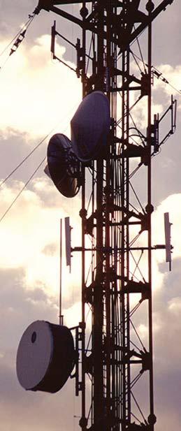
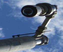
8 6 TELECOMMUNICATIONS Telecommunications Program Program Description Guide deployment of a communications backbone to serve ITS deployments on major corridors. Implement and manage the statewide ITS wide area network (WAN) to support ITS deployments. Manage the operations and maintenance program for the statewide ITS telecommunications network to support ITS deployments and various ITS research and development initiatives. Manage all of the Florida Department of Transportation s (FDOT) Federal Communications Commission (FCC) radio licenses (over 600 licenses). Manage the Wireless General Manager Agreement, a resourcesharing public/private partnership, which places commercial wireless carriers on FDOT rights-of-way with Lodestar/American Tower. Develop operations standards and equipment specifications to support District telecommunications initiatives in their ITS, Maintenance, and Traffic Incident Management programs. Major Accomplishments Satellite earth station at Lake City. Continued a project to expand the ITS WAN with a gigabit Ethernet connection between the FDOT Traffic Engineering Research Laboratory (TERL) and the State Emergency Operations Center (SEOC) in Tallahassee. The connection will support the SEOC with streaming video and data from the District regional transportation management center (RTMC) during emergency operations as needed over FDOT s private networks. The City of Tallahassee traffic systems fiber infrastructure will provide the fiber optic connection. Completed work to install the ITS WAN in Districts One and Seven. Optical path tests and performance parameter measurements were made to assure reliable long-distance communications. Awarded a project for a one-gigabit Ethernet connection between the RTMCs in Districts One and Seven to improve the reliability of the ITS WAN until District fiber optic deployments are complete along I 75. Provided ITS statewide telecommunications services comparable to those of major telecommunications carriers. Our improvements to backup power systems and emergency generators played a major role in the delivery of these services leaving us far less vulnerable to network outages. Won the Intelligent Transportation Society s Best of ITS in the Best New Innovative Product, Service, or Application for the ITS facility management (ITSFM) system. Continued implementation support of the ITSFM system to better enable FDOT Districts to manage their overall telecommunications networks, field system configuration, and components. Upgraded ITSFM software to add new devices, features, and capabilities to the software. Completed work in District Six in populating all ITS facilities within the ITSFM. This included approximately 70 miles of fiber optic cable and conduit system, 70 miles of power distribution system, 75 wireless radio sites, and 500 ITS equipment sites. This work fully implemented the ITSFM District-wide. Designed a 4.9 GHz wireless freeway management system (FMS) along a rural area of I-75 north of Tampa for District Seven. This system included the installation of four closed-circuit television pole sites consisting of four cameras and two vehicle detection devices that were integrated into the statewide microwave system and transmitted to the Tampa Bay SunGuide Center through the statewide telecommunications network infrastructure. District Seven adopted this design to aid in a similar FMS deployment for I-75 south of Tampa. Began a major program to support Florida s Turnpike Enterprise (FTE) in repairing and refurbishing or replacing 19 radio towers and the associated antenna and tower lighting systems. Central Office is providing scope development, procurement support, and field inspection services.

9 7 Awarded three contracts to replace towers at three FTE sites. The work will be completed in the upcoming fiscal year. Central Office will provide field inspection services and contract monitoring for FTE on these projects. Began a project to support the Florida Rail Enterprise in radio systems operations. Researched requirements for transferring ownership of all radio system licenses from CSX to FDOT in support of new District Five SunRail operations. Worked closely with CSX to initiate transfer of all required FCC radio licenses. Established relationship with the Association of American Railroads to facilitate additional required transfers of railroad signal system radio licenses. Coordinated with FDOT District Five stakeholders. Experienced a reduction of three wireless collocation subleases under the Lodestar/American Tower Wireless General Manager Agreement as a result of obsolescence of wireless paging technology. Five new wireless collocation subleases were added as a result of expansion of the wireless industry and deployment of wireless broadband technology. Awarded a contract for deployment of permanent emergency generator power systems at the Cocoa Florida Highway Patrol (FHP) statewide ITS telecommunications network site to provide continuity during power outages. Completed a contract for deployment of additional permanent emergency generator power systems at the Madison, Marianna, and Quincy statewide ITS telecommunications network sites to provide continuity during power outages. Completed installation of a multicast repeater for FDOT s radio system at the Duchaine site in Districts Three. Interconnected this site into the District Three wide area radio system voter in Chipley. Completed installation of a multicast repeater for FDOT s radio system at the Cocoa FHP site in District Five. Interconnected this site into the District Five wide area radio system and expanded their radio system voter in Wildwood to accommodate future sites. Completed a scope of services to deploy an FDOT owned radio repeater at the Miami 79th Street Causeway tower site in District 6. Bids are due in July Completed a contract to erect a tower recovered from another project in District Two at the Perry Mobile WiFi trailer. maintenance site. Completed installation of a multicast repeater at the Perry site for FDOT s radio system filling a gap in radio coverage. Interconnected this site into the District Two wide area radio system voter in Lake City. Performed an interoperability study to streamline communications from a very high-frequency (VHF) low band system into the State Emergency Operations Center for emergency management. VHF high band equipment was installed at the Duchaine site. Procured 1,087 VHF low band mobile radios to complete a five-year program to replace over 1,800 mobile radios in FDOT s radio system. Districts are completing the installation of these mobile radios. Procured and programmed 63 ultra-high frequency mobile radios to replace the existing radios in FTE s radio system. Procured multicast repeater radio equipment for three sites to fill gaps in radio coverage. Trained District Five trainers in the operation of the new mobile radios and their operation in the new repeater network. Provided assistance and support to the South Florida Water Management District (SFWMD) with recommended upgrades to their VHF low band radio system. Performed noise testing at several SFWMD radio sites to determine design parameters for system upgrades. In return, SFWMD has offered to share space on their towers at no cost to support FDOT s radio system expansion to improve radio coverage in Districts One, Four, and Five. Continued reporting weather data from eight field weather stations in support of the Federal Highway Administration s Clarus initiative, a program to provide information to all transportation managers and users to alleviate the effects of adverse weather (e.g., fatalities, injuries, and delays). Continued contractor work for two ground stations for use in conjunction with the National Oceanic and Atmospheric Administration satellite-based data collection service to deliver bridge sensor data to Districts and their stakeholders. Maintained WiFi Internet access at four welcome centers, which has served over 145,000 users to date with an average of 600 login events per week. Deployed the mobile WiFi trailer at Operation Radar II, a Florida communications interoperability training exercise for local, state, and federal agencies. Installed a forward-looking infrared camera on the WiFi trailer to assist with remote nighttime roadway monitoring for an upcoming deployment at Paynes Prairie. Assisted FDOT State Maintenance Office (SMO) with their rest area WiFi deployment project. Drafted a WiFi test plan for ensuring new rest area WiFi Internet services are adequate. Coordinated with installation vendors to perform testing at first installed location. Provided feedback to SMO on recommendations for future testing. Began coordination effort to perform future testing at all rest areas.

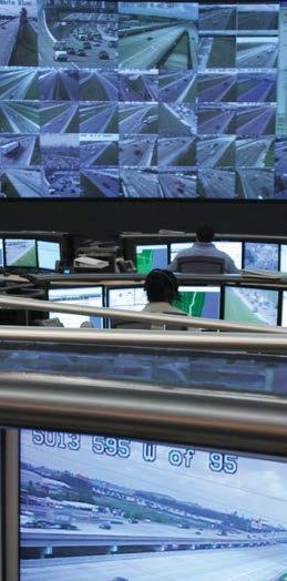
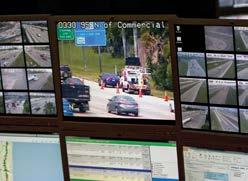
10 8 TRAFFIC SYSTEMS Traffic Systems Program Description Operate the Traffic Engineering Research Laboratory (TERL). Develop, maintain, update, and publish minimum specifications for traffic control signals and devices; evaluate and certify/approve these devices for use in Florida. Develop, implement, and maintain the Approved Product List (APL) vendor quality system program and product approval programs. These programs are used to list equipment on the Florida Department of Transportation s (FDOT) APL to ensure a uniform system of traffic control devices in Florida. Develop, update, and support standard specifications, standard drawings, and payment methods for traffic control device installations. Develop and implement an internal quality system compliant with an industry-accepted standard for quality management systems of product certification bodies (International Organization for Standardization [ISO] 17065). Provide testing, verification, and validation services for ongoing development of the FDOT SunGuide software, Florida s advanced traveler information system, and other statewide transportation software and system applications. Provide support services and infrastructure for intelligent transportation systems (ITS) telecommunications and central data warehouse functions. Provide technical assistance and training relating to the design, implementation, and operation of traffic control signals and devices used in Florida. Provide statewide specifications and standards support for red-light running camera equipment and testing. Represent Florida on national technical advisory groups that develop traffic control and ITS device standards. Maintain and update traffic operations asset inventory. Video wall inside the TERL.

11 9 Major Accomplishments Light tunnel at the TERL. Maintained a statewide APL vendor quality system program to evaluate quality systems of traffic control signal and device vendors requesting listing of their products on the APL accepted six, and re-accepted 31 quality systems. Maintained a statewide APL product approval program to certify/approve traffic control signals and devices used in Florida approved 47 products. Tracked permit requests for traffic control products and issued seven permits. Tracked and addressed nine nonconformance reports received from end-users through issuing/tracking corresponding corrective action requests to APL vendors until resolution. Developed and updated multiple FDOT contract documents, including updates to 10 installation and equipment specifications for the FDOT Standard Specifications for Road and Bridge Construction (SSRBC). Updated and consolidated requirements for traffic control signals and devices that were formerly published in FDOT s Minimum Specifications for Traffic Control Signals and Devices (MSTCSD) into corresponding sections of the SSRBC. Revised the FDOT specifications for network devices to incorporate minimum requirements for media converters and alternate port configurations. Revised internal quality system documentation for conformity to new standard (ISO 17065) superseding ISO Guide 65 for product certification bodies. Developed and published new on-line Product Certification Handbook detailing APL product approval/certification and permitting processes to vendors and end-users. Developed and implemented APL product evaluation tracking system, including automated evaluation task assignments. Coordinated statewide submittal reviews and structural approvals for red light running cameras. Performed end-to-end system testing of various SunGuide software components, interfaces, and field devices, including independent verification and validation testing. Represented the American Association of State Highway and Transportation Officials on the Joint Committee on the National Transportation Communications for ITS Protocol (NTCIP) and the NTCIP DMS Working Group regarding the development and deployment of NTCIP requirements for traffic control signals and devices. Managed and/or supported research projects for the following subjects: o Development of automated testing tools for traffic control signals and devices; o Managed lanes operations, including time-of-day versus dynamic pricing; o Human factors research, regarding pedestrian buttons, illuminated street name signs, DMS character sizes, and additional traffic signal heads; and o Development of roadway and intersection safety calibration factors o Hurricane survivability of traffic signal attachment hardware.
 Secretary as required by the Florida Administrative Code.")

12 10 CVO Commercial Vehicle Operations Program Description Promote commercial motor vehicle safety as it relates to commercial vehicle operators as well as the traveling public. Chair and manage the Commercial Motor Vehicle Review Board representing the Florida Department of Transportation (FDOT) Secretary as required by the Florida Administrative Code. Manage Florida s Commercial Vehicle Information Systems and Networks (CVISN) program, a nationwide program under the direction of the Federal Motor Carrier Safety Administration, which strives to streamline commercial vehicle industry regulations and helps motor carriers and motor coach operations in Florida function more efficiently. The Florida CVISN team consists of various partners, including FDOT, Department of Highway Safety and Motor Vehicles, Department of Revenue, Department of Agriculture and Consumer Services (DACS), and private sector representatives from motor carrier companies and the Florida Trucking Association. The CVISN program focuses on safety enforcement resources in high-risk commercial operators; integrating federal and state regulatory systems to improve access to and verification of operating credentials; improving efficiency through electronic screening of commercial motor vehicles; and enabling online application and issuance of operating credentials. Major Accomplishments Reviewed 813 protests received by the Commercial Motor Vehicle Review Board, granting full or partial relief to 308 citations for a total relief in excess of $247,000. Constructed two virtual weigh stations, also known as virtual bypass system, at the Flagler Weigh Station (north and south bound) and at the Wildwood Weigh Station (north and south bound). These systems consist of a pole mounted license plate reader capable of providing a guaranteed 24 hour read rate of 80 percent of both the alpha and numerical information off of a truck front-mounted license plate along with an 80 percent read rate of the jurisdiction. These systems will also provide an overview shot that will aid in identifying potential violators. Upgraded the tag recognition system to detect vehicles passing through the DACS inspection stations that are listed in the Performance and Registration Information Systems Management (PRISM) database as having an out-of-service order or that are listed in the Florida Highway Patrol s hot list file as having an outstanding unpaid ticket. Continued development of Florida s commercial vehicle container number database system for tracking container/vehicle movements and presenting data graphically. This database provides storage and the ability to query container numbers and ancillary data (container location and time-stamp) from DACS and license plate reader system data from the Motor Carrier Size and Weight system.
. Develop and update scope of services, policies, and procedures for FDOT s Road Ranger and Rapid Incident Scene Clearance (RISC) Programs.")
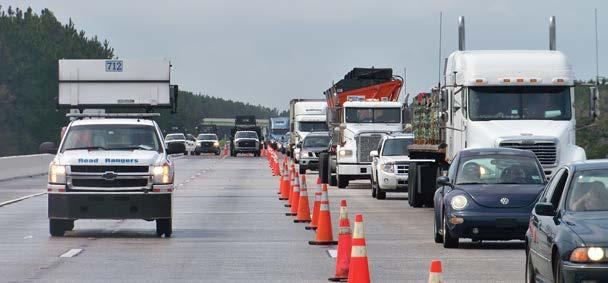
13 11 Traffic Incident Management TIM Program Description Provide technical support and assistance to the Florida Department of Transportation s (FDOT) District Offices and other partners in regards to traffic incident management (TIM). Develop and update scope of services, policies, and procedures for FDOT s Road Ranger and Rapid Incident Scene Clearance (RISC) Programs. Support the Federal Highway Administration s (FHWA) Strategic Highway Research Project (SHRP 2) National TIM Responder training efforts. Assist the State Emergency Operations Center with evacuation management. Collect TIM-related data to determine areas of improvement for future planning. Major Accomplishments Prepared and published the RISC Annual Report October Prepared and published the Road Ranger Comment Card Annual Report - August Prepared the fourth Annual Road Ranger Responder Survey. Supported the web site. Enhanced outreach to District TIM programs ongoing video conferences. Conducted a day and a half TIM Program Managers meeting in Orlando. Continued deployment of the Statewide Law Enforcement Radio System with ongoing training and support to the Districts. Coordinate the revision and updating of the Open Roads Policy, in cooperation with the Florida Highway Patrol. Increased Road Ranger coverage in the Pensacola area (I-10 and I-110) to 24-hours a day/7-days a week coverage. Lane coverage miles remained the same. Established New Road Ranger contracts in Districts One, Two, Six, and Florida s Turnpike Enterprise. The District Six contract adds a medium-duty or Class C wrecker to respond to larger disabled vehicles, such as dump trucks and buses, and remove them from the travel lanes. Florida s Turnpike Enterprise will add additional wrecker units in South Florida. Developed an incident management track for Transpo 2012 in Bonita Springs, Florida. Added a new TIM team in Bay County in District Three. Jefferson County is participating in the Big Bend TIM team. Supported SHRP 2 National TIM Responder Train the Trainer courses in Fort Lauderdale, Bradenton, Orlando, and Jacksonville. First responders and Road Rangers.
 in a costefficient manner to better accommodate Florida s rapid growth in population, tourism, and")
14 12 Statewide Operations Performance Measures Demonstrating ITS Benefits By Elizabeth Birriel, FDOT, and Anita Vandervalk, Cambridge Systematics The Florida Department of Transportation (FDOT) is committed to implementing fully integrated, statewide intelligent transportation systems (ITS) in a costefficient manner to better accommodate Florida s rapid growth in population, tourism, and commerce. ITS is a key Transportation System Management and Operations (TSM&O) Program strategy. It employs realtime information systems and advanced technologies as transportation management tools to improve the movement of people, goods, and services. As the TSM&O Program and ITS evolve in Florida, developing and reporting operations performance measures is a high priority for FDOT to demonstrate and document the benefits of ITS. When FDOT s ITS Program began addressing performance in 2004, FDOT s Districts did not have automated data collection systems and were initially limited to measures of basic production and usage (output). These initial output measures reported statewide were total annual 511 calls, Road Ranger stops, and centerline miles of limited-access highways managed by ITS. The proliferation of ITS deployments and integration allows more accurately documented and reported performance measures and their resulting benefits (outcome). FDOT identified three ITS outcome performance measures that were subsequently approved by the Florida Transportation Commission in These measures are incident duration, travel-time reliability, and customer satisfaction. Available data for the incident duration and customer satisfaction measures were collected and reported beginning in Performance Measures Results For fiscal year (FY) 2012/2013, all output and outcome measures were reported. Data was collected for these reported measures for the period beginning July 1, 2012, and ending June 30, Miles Managed by ITS As of June , 1,343 miles of limited-access, Florida Intrastate Highway System facilities were managed by ITS. This is 64 percent of the total system mileage. 511 Calls The Florida 511 (FL511) traveler information system logged approximately 1.8 million calls during the 12-month period from July 2012 to June The FL511.com web site received 726,649 visitors during that time. There were 631,821 visits to the 511 mobile applications in the past year, which is a large increase over past years. At the end of
15 13 June 2013, there were 9,026 Twitter subscribers. Tracking phone calls to Florida 511 is no longer the sole indicator of system usage as more travelers are using automated and mobile applications to customize their experience. Over 14 million messages, calls, visits, and alerts were made in FY , keeping travelers on Florida s highways informed. Road Ranger Stops Road Ranger service patrols made 382,570 stops statewide during FY All seven Districts and Florida s Turnpike Enterprise provided Road Ranger services in this time period. This a 2.2 percent decrease from FY Incident Duration FDOT roadway clearance duration varied from month-to-month, but the annual average time from the reporting Districts was minutes. The Open Roads clearance duration averages about 38 minutes for the reporting Districts. This is well under the Open Roads Policy target of 90 minutes. Travel Time Reliability Travel time and planning time indices were calculated for ITS-managed corridors in each District. The planning time index (PTI) is the 95th percentile travel time divided by free flow travel time. PTI is now being used instead of the buffer time index (BTI). BTI has proven to be an unstable indicator of performance over time because the mean and the 95th percentile can change at different rates from one year to the next. This can lead to a situation where other metrics indicate that congestion and reliability have improved, but the buffer index degraded. Roadway segments that consistently show congestion and unreliable travel times are tracked and reported on quarterly. The most unreliable section calculated throughout the state is on I-10 eastbound in District Two (Jacksonville area) during the morning peak period (PTI of 3.11). Customer Satisfaction A customer satisfaction survey was conducted during July and August FDOT interviewed 2,100 drivers across Florida to explore usage of, attitudes toward, and perceptions of FDOT s ITS services. The most significant findings of that survey were: The days of radio and television traffic reports dominating traveler market share will eventually come to a close. This was evidenced in previous years by the generational divides in radio and television traffic information consumption. Young drivers no matter how often, where, or when during the day they drive were less dependent on these traditional traffic information sources and more inclined to turn to the internet for traffic information. Use of traditional sources is generally down across all subgroups. By far the most popular alternative source is dynamic message signs, which are used by 79 percent of drivers. The next most popular sources for traffic information are in-car navigation systems (34 percent) and web sites on a home or work computer (23 percent). Drivers who use FL511 are effusive in their praise of it, are increasingly trusting of it, and are likely to act on the information it provides. However, only one-quarter of users take advantage of the service before leaving for their destination. That is, they often wait until encountering traffic congestion or an accident before turning to the FL511 traveler information system. The Road Ranger Program and dynamic message signs continue to receive overwhelmingly positive ratings by customers and these services are highly valued and trusted by the driving public. When asked what additional types of traffic information FDOT should provide, most drivers say they would find information on alternate routes useful. Also, there is a large contingent of drivers who would like to be provided with additional information about all of the tested choices. Summary FDOT continues to improve data collection, analysis, and reporting related to operations performance measures. Quarterly reports are currently being generated for all six performance measures for FY


, operational treatments have reduced yearly congestion costs in major metropolitan areas by nearly $7 billion.")

16 14 SM&O TTransportation Systems Management & Operations Managing and Operating for an Efficient Transportation System Transportation Systems Management & Operations Capitalizing on Limited Transportation Funding By Elizabeth Birriel, FDOT, and Ingrid Birenbaum, Atkins TSM&O has been shown to improve travel time reliability and is expected to result in cost savings. Since adopting transportation systems management and operations (TSM&O) as a program in 2010, the Florida Department of Transportation (FDOT) has completed some initial efforts and accomplished many TSM&O goals in fiscal year 2012/2013. TSM&O uses a coordinated, integrated approach between organizational entities that plan, design, construct, operate, and maintain transportation facilities. Agency partners leverage multiple technologies to maximize transportation operations instead of choosing between operations and capacity solutions. Intelligent transportation systems and technology components are included, but improved incident management practices, better flow through work zones, increased and more effective use of mass transit, and changes to higher landuse density play key roles. TSM&O has been shown to improve travel time reliability and has the potential to result in cost savings; based on data collected by the Texas Transportation Institute as described in its Urban Mobility Report (2011), operational treatments have reduced yearly congestion costs in major metropolitan areas by nearly $7 billion. TSM&O offers ways to capitalize on limited transportation funding to maximize transportation system efficiency and effectiveness. FDOT s TSM&O Program is based on: TSM&O also promotes outreach to local and regional transportation stakeholders and partners to achieve truly multimodal, regional solutions. Performance measurement, Active management of the multi-modal transportation network, Positive safety and mobility outcome delivery to Florida s traveling public, and Delivery of cost-effective solutions through benefit/cost ratio analyses. This operations-oriented approach addresses increasing demand, capacity constraints, weather, incidents, multiple jurisdictions, and other barriers by building on existing activities and plans to establish stable processes and formal institutional arrangements that are critical for effectiveness.
17 15 FDOT s TSM&O leadership and task teams continued their efforts to guide and implement TSM&O actions that provide the groundwork for establishing and maintaining the TSM&O Program. These teams have focused on near- and longer- term implementation actions at both the Central and District Office levels. Near-Term Implementation Actions Central Office Implement FDOT s formal TSM&O Program, Provide tools, guidance, and policy, Finalize and publish TSM&O Strategic and Business Plans, Develop accountability mechanisms, and Conduct TSM&O workshops to support local Districts. Districts Select focus areas under the program, Identify a champion in each District, Define networks (freeways and arterials) for performance-based management through TSM&O, and Develop/update District TSM&O Strategic and Business Plans. Workshops FDOT completed a series of TSM&O workshops in the local FDOT Districts. Topics included how TSM&O could be implemented in each individual District, given their unique characteristics and different local needs. Participation was open to all functional areas that could potentially benefit from TSM&O, such as Planning, Project Development, Design, Construction, Maintenance, and Traffic Operations. At some workshops, external participants included metropolitan planning organizations (MPO), county/ city planning/engineering staff, and representatives from airports, seaports, and transit. Discussion topics included an overview of TSM&O actions at the national, statewide, and local District levels; introduction of tools for benefit/cost; and workshop exercises in which local TSM&O focus areas were selected. Primary objectives of the workshops included: Help participants better understand TSM&O, Foster an understanding that all functional areas have a role in planning for and implementing TSM&O, Identify District focus areas for implementation, Develop action items to continue the local program, and Introduce current TSM&O documentation. Workshop outcomes included definitions of how all functional areas within FDOT as well as local transportation partners could plan for and implement TSM&O, construction of a framework for inter-agency coordination, and gap analysis/identification to address barriers to TSM&O implementation. Longer-Term Implementation Actions The workshops indicated a need for the following long-term implementation actions: TSM&O formally considered in FDOT/MPO planning and project development processes and manuals, TSM&O reflected in key FDOT policies and procedures, Construction projects incorporate TSM&O strategies into maintenance of traffic plans, and Real-time infrastructure monitoring through remote sensors provided for maintenance activities. FDOT made the following commitments: Organizational changes/evolution to operations and management of all surface transportation systems/networks in real time, and Using TSM&O as a performance driven approach for solving congestion problems using technology tools and management and operational strategies to identify and respond to the causes of congestion in real-time. FDOT has taken significant steps to integrate planning and operations; develop high levels of coordination and communications with local traffic, transit, freight, and other modal entities; maximize the efficiency of existing infrastructure; and make use of tools and data for mobility and safety outcomes.
 Strategic Plan back in 1999.")
18 16 Ten-Year ITS Cost Feasible Plan Realizing a Vision By Gene Glotzbach, FDOT The Florida Department of Transportation (FDOT) has come a long way since development of the Intelligent Transportation System (ITS) Strategic Plan back in That ITS Strategic Plan recommended creation of an ITS Program managed out of the Central Office, and the dedication of funding to support deployment of ITS statewide. The initial allocation of funds totaled $496 million over a ten year period. One of the initial efforts of the newly created ITS Program was to develop a plan to deploy ITS statewide. That plan was named the Ten- Year ITS Cost Feasible Plan (CFP) and provided funds to every District to deploy ITS. Before developing the ITS Strategic Plan, the state had only three small ITS deployments in Jacksonville, Orlando, and Miami. At that time, ITS projects had to compete for funding with high-profile capacity improvement projects, which could not keep up with the capacity improvement needs of the state. The cost to purchase rights-of-way to build out of congestion problems has become cost prohibitive in the larger urban areas. The limited funding to deploy ITS was a roadblock for the implementation of ITS. However, the FDOT Executive Board recognized that because the cost to add capacity was so great, FDOT needed to make every effort needed to improve the efficiency of our limited-access facilities to get the most out of what we have. They agreed to set aside dedicated funds to deploy ITS. With the allocation of a dedicated funding source and adoption of the CFP, funds were distributed to the Districts and ITS deployment began to accelerate. Before adopting the CFP in 2002, there were only about 30 miles total of ITS deployed in Jacksonville, Orlando, and Miami. Now ten years later, every District has deployed some ITS and constructed sophisticated transportation management centers to manage their deployments. According to the latest performance measures report, which reports on the miles managed by ITS (as one of the three output measures), FDOT has been busy deploying ITS devices over this time. The Fiscal Year 2012 Performance Measures Report indicates that the number of miles managed by ITS has grown to 1,258 centerline miles. This represents about 60 percent of the state s total miles of limitedaccess facilities. With the completion of projects that are now in the design or construction phase, that percentage will increase to about 90 percent. In other words, seven of FDOT s eight Districts will have completed their portions of the CFP. This will bring FDOT close to full build out of the initial CFP. No other state in the nation has had this kind of success in deploying ITS in a coordinated and comprehensive manner. Had it not been for the revenue shortfalls due to the recent economic climate and its resulting reduction in ITS funding along with other programs, FDOT would have been looking at full deployment of the CFP with the completion of those projects that are now in the production stage. That would have put the FDOT right on track to finish the CFP in its ten-year timeframe.
 required states to provide a real-time systems management information program.")

19 FDOT s Ahead with FL511 Implementing Real-Time Systems Management Information Program 17 By Gene Glotzbach, FDOT The Safe, Accountable, Flexible, Efficient Transportation Equity Act: A Legacy for Users 1201 legislation, enacted by Congress, and codified in the Code of Federal Regulations Part 511 (23 CFR 511) required states to provide a real-time systems management information program. The point of this legislation is to require states to provide information to the public concerning road construction, road/lane closures, road conditions (incidents), and travel times. The implementation schedule as provided in 23 CFR 511 is broken down into two stages. Stage one covers interstate routes and stage two addresses routes of significance in metropolitan areas. The requirement is for 24/7 coverage. States must implement stage one, regarding the interstate system, by 2014, and stage two, roadways of significance, by CFR 511 was discussed at the National 511 Deployment Coalition meeting in Phoenix in April 2013, with the significant take away from this legislation being that states don t have to push this information out, they only need to make it available. This helps to simplify the task of meeting the requirements of this legislation. It means that a state does not necessarily have to develop a dissemination system if the information is available through other means. To comply with the intent of the legislation, a state does not have to disseminate the information at one point of access. That is, a state does not have to collect and aggregate the information into a single location for the public to access. The information can be available through multiple access points. Florida is in a good position to meet this legislation as this information is readily available now or will be available in the near future. The Florida Department of Transportation s (FDOT) traveler information system (FL511) is currently providing the required information for the interstate system, so FDOT has already met the requirement for stage one for the past couple of years. FDOT is providing road construction, road/lane closure information, incident information, and travel time information on all of the state s limited-access facilities. FDOT provides all the information to satisfy the can be found through the FL511 system as well as alternate sources, such as the Florida Highway Patrol web site for incidents and road closures, FDOT s construction web site for construction information and lane closures, and through access to third-party web sites for travel time information. The same information for roadways of significance is available through the web site noted above. Because of the availability of this information for roadways of significance, FDOT also meets the stage two requirements. The only outstanding issue is that FDOT has not provided a designation for the routes of significance and FDOT has not integrated them into the FL511 system. Overall, FDOT wellpositioned to meet the legislation s requirement for stage two long before 2016 by finalizing the determination of the routes of significance.

20 18 I-75 Deployment in Gainesville Watching Paynes Prairie By Peter Vega, FDOT Smokey conditions near Paynes Prairie on U.S. 441 (Photo courtesy of Donna Green-Townsend, WUFT) In the wee hours of January 29, 2012, smoke from a fire on Paynes Prairie mixed with fog over I-75 and reduced visibility to zero feet instantaneously. A multi-vehicle crash resulted in 11 fatalities and several injuries. The Florida Department of Transportation (FDOT) maintenance and Florida Highway Patrol had been patrolling I-75 in the area of Payne s Prairie to monitor visibility since the road had been closed earlier and had only been reopened about 45 minutes before the crashes occurred. For them, it appeared that visibility was clear one minute and zero the next. Only about a onehalf mile section of the roadway suffered such a severe reduction in visibility. Historically, due to elevations in that area, it is not uncommon for fog and smoke to settle around Paynes Prairie. Deploying an intelligent transportation systems (ITS) project in the area had already been a topic of conversation, but this major crash highlighted the severity of the issue. Due to that incident, Representative Perry proposed legislation to fund projects in Florida to mitigate visibility issues caused by fog/smoke conditions and the section of I-75 around Paynes Prairie was a project high on his list. This ITS project is scheduled to be let in September Construction is expected to begin in late 2013, with project final acceptance by the end of It extends from the Alachua-Marion County Line to SR 24/ Archer Road on I-75 and also covers the section of US 441 in Paynes Prairie. It includes all the typical features of a full ITS deployment fiber optic cable, dynamic message signs (DMS), closedcircuit television (CCTV) cameras, and microwave vehicle detection system (MVDS). Some added features also included are: BlueToad devices, thermal imaging cameras, visibility sensors, and flashing beacon signs on arterials.

21 19 FDOT will install fiber optic cable along I-75 and connect to Gainesville s Smartraffic Advanced Traffic Management System at SR 121/Williston Road and SR 24/Archer Road, while devices on US 441 will connect to the system wirelessly. During normal business hours, the Gainesville Traffic Management Center will control the system and, by using a high-speed dedicated connection to their system, the Jacksonville Transportation Management Center will control the system on nights, weekends, and when there is a need for additional support. FDOT will also install DMSs and arterial DMSs along I-75 and US 441. Two DMSs will be installed on I-75 northbound to alert motorists entering Paynes Prairie. One of these will be south of CR 234 so that motorists will be able to exit the roadway if needed. The other northbound DMS will be north of CR 234, but south of Paynes Prairie so that any motorists entering I-75 from CR 234 will be warned of conditions ahead so they are prepared as they drive through Paynes Prairie. A third DMS will be installed on I-75 southbound between SR 24/ Archer Road and SR 121/Williston Road. On US 441 two DMSs will be installed one each for northbound and southbound traffic approaching Paynes Prairie. Bosch CCTV cameras will be installed along I-75 in order to achieve full coverage of the roadway. They will be spaced approximately one mile apart, with adjustments in location to avoid physical or geometric obstructions for viewing distance. On US 441, a CCTV camera will be installed at each end of Paynes Prairie with another being installed close to the observation platform near the midway point of US 441. MVDS will be installed on CCTV poles to monitor traffic flow. Three BlueToad devices will be installed and used for travel time and other data collection. Additionally, there will be some other features included in the project, specifically to mitigate problems resulting from poor visibility. Flashing beacons will be installed on static signs on SR 121 approaching I-75 and on US 411 approaching Paynes Prairie. These beacons will be activated when visibility is low so that motorists can change their route or proceed with caution. Thermal imaging cameras, also known as FLIR (Forward Looking Infrared Radar) cameras, will be installed on I-75 and US 441 midway through Paynes Prairie. At night, during fog or heavy smoke, traffic can still be monitored with these cameras since the cars can be detected by their heat signature, which is the thermal energy they emit. Optical Scientific, Inc. visibility sensors will also be installed on I-75 and US 441 around Paynes Prairie. These will measure visibility, which will aid in determining when to close the roadway. This is a far more accurate and timely way of determining low visibility conditions, rather than sending personnel into the field, mainly because it provides an accurate measurement of the entire segment rather than just a subjective assessment where personnel are located in the field. Eight sensors will be installed on I-75, with one on both ends of Paynes Prairie on the northbound and southbound sides of the road aiming toward Paynes Prairie. Another four sensors will be installed at the midway point of I-75 in Paynes Prairie, with two on the northbound side and two on the southbound side. They will be located next to each other and will aim away from each other. In this way, the sensors will monitor visibility on the approximately 2.5-mile section of I-75 through Paynes Prairie. Since US 441 is a narrower roadway, sensors will only be installed on one side of the road. Each end of Paynes Prairie on US 441 will be equipped with a visibility sensor that aims toward the center of US 441. Two more visibility sensors will be located at the midway point of US 441 in Paynes Prairie aiming outward. In this way also, the nearly two-mile section of US 441 will be monitored with visibility sensors. In summary, deployment of this ITS project with these added features, will improve accuracy of visibility measurement, expedite detection of poor visibility, provide information to motorists approaching the area of low visibility, and allow rapid response of law enforcement and others to close the roadway if needed. This will greatly reduce the likelihood of accidents related to poor visibility such as the tragedy in January 2012.
 equipment.")

22 20 Specifications Consolidation Improving Consistency and Quality of FDOT Specifications By Gene Glotzbach, FDOT, and Ron Meyer, Atkins The Florida Department of Transportation (FDOT) was among the first states in the nation to develop statewide minimum requirements for intelligent transportation system (ITS) equipment. The first of Florida s ITS specifications were published in 2006 and the minimum requirements for equipment and systems contained within the ITS specifications have evolved over the years to keep pace with changes in FDOT s needs, technology, and practice. Along with evolutions in technology, ITS equipment has also increasingly become mainstream components of traffic control systems used for highways and intersections. Past distinctions between what is considered a traditional traffic control device and what is an ITS device have diminished. As a result, FDOT began an effort to update and consolidate many requirements for both highway and intersection equipment. These include specifications contained within the FDOT Standard Specifications for Road and Bridge Construction as well as requirements in a number of other documents that govern the design and construction of Florida s transportation system. At the beginning of this millennium, Intelligent Transportation Systems and Traffic Engineering and Operations were separate offices within FDOT. Each operated independently, though there was a high degree of commonality between them. As a result, many early ITS program documents, including specifications, were developed and maintained separately. As the similarities and common goals of these offices developed, the two were ultimately merged; ITS became a specialty area within the Traffic Engineering and Operations Office. Given today s reality of close coordination between integrated programs, systems, and services involving the safe and efficient movement of people and goods, the value of collaboration and consolidation of disciplines with shared needs and goals is clear. FDOT strives for consistency, predictability, and repeatability in many areas. To advance these objectives, offices within FDOT collaborate to reduce duplication, increase efficiency, and realize other benefits through consolidation. The consolidation of specifications supports these principles by improving consistency in requirements that are applied within multiple disciplines and involve numerous stakeholders. The Traffic Engineering and Operations Office plays a large role in the consolidation of minimum requirements for a variety of products and materials due to the technical expertise of their multidisciplinary staff and the office s responsibility for traffic control device approval. Specifications

23 21 Requirements governing traditional traffic control devices and ITS equipment were identified as prime candidates for consolidation for a number of reasons. Among them was the desire to fully integrate ITS and Traffic Engineering and Operations as well as strengthening FDOT s position with respect to how ITS products are categorized as traffic control devices within a larger traffic control system. Classification of products as traffic control devices (or ancillary equipment used within a traffic control system) requires them to be vetted and pre-approved by FDOT as a condition of acceptance on transportation projects. Pre-approved products are then listed on FDOT s Approved Product List. While the ITS and Traffic Engineering and Operations Offices have been integrated for some time, FDOT specifications still maintained many separate (and in some cases duplicated) requirements for equipment used on highways and signalized intersections. In addition, many past institutional restrictions and barriers that segregated ITS from signalization resulted in significant duplication and imposed unnecessary restrictions. For instance, there were duplicate requirements for many commonly used items, such as conduit and pullboxes. This included separate payment methods that could not be interchanged between ITS and signalization system designs even though the material and installation requirements for these products were practically identical. While the old system could be made to work, it did not necessarily reflect the current state of practice. In fiscal year , FDOT staff has continued to work closely with the FDOT Specifications, Estimates, and Roadway Design Offices to migrate and consolidate technical content previously found in different areas of multiple documents into new and expanded sections of the FDOT Standard Specifications for Road and Bridge Construction. This multi-year effort started in 2012 and is now more than 50 percent complete. The effort is significant, as this task has also uncovered and initiated significant changes to technical content. In addition to moving and combining existing requirements, this activity also involves significant research and investigation into the technical content of the old requirements. Many of the requirements that are being relocated have existed for decades and are in need of updates based on current practice, new needs, and technological advancements. Along with contributing to all of the updates and changes happening in the FDOT specifications, the Traffic Engineering and Operations Office has also been assisting with outreach to help explain the overall scope of the consolidation effort to internal and external stakeholders. This includes developing bulletins and providing guidance to designers, contractors, inter-agency colleagues, and others on the use and application of requirements as they are updated. FDOT anticipates that changes to the remaining specifications and impacted pay items, design standards, and other documents will be complete by July 2015.
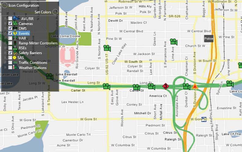
24 22 Data, Data, Data! How do we Manage it? By Elizabeth Birriel, FDOT, and Clay Packard, Atkins The Florida Department of Transportation (FDOT) is responsible for over 12,000 miles of roadways. Out of that, more than 3,000 miles are implemented with some type of traffic sensor that provides a wealth of data to FDOT s Intelligent Transportation Systems (ITS) Program in the Traffic Engineering and Operations Office along with other FDOT offices. That s a lot of miles and a lot of data! Since 2003, FDOT has been working with a prototype system for archiving data; however, in 2013 this all changed. FDOT launched their first complete production system central data warehouse through the University of Maryland s (UMD) Center for Advanced Transportation Technology. Now both live and historical detector and event data are available from UMD s Regional Integrated Transportation Information System (RITIS). This provides FDOT with a high reliability system, which also packs horsepower through a fleet of server and storage systems. Additionally, FDOT had a few unique requirements that were met by enhancements to RITIS. New tools developed specifically for FDOT s needs now produce travel-time reliability and roadway performance measures. Along with the ITS Program, FDOT s Planning and Safety offices as well as university and consulting firms also have access to data. RITIS also has an application programming interface for FDOT-developed tools to access and process data from within external software. FDOT s detector deployment along most of their limitedaccess facilities is predominately point detectors. Thus, as a starting point, SunGuide software, Florida s advanced traffic management software, was modified to send live detector data to RITIS; UMD initially integrated this data into their existing system. The next step will be for RITIS to also use probe data from FDOT s probe detector deployments provided by the SunGuide software and probe data from Nokia s third-party data feed. Each probe detector and the segment of roadway they cover will be shown on traffic maps. The probe detector icons will be colored to represent the status of the device and the roadway segments will be colored according to the traffic conditions being detected by the device. With just one or two clicks of the mouse, graphs and other forms of data analysis are also available. FDOT has a contract with Nokia to provide statewide traffic speed data for limited-access facilities. This data will also be available in RITIS s Vehicle Probe Project Suite. The Vehicle Probe Project Suite allows agencies to support operations, planning, analysis, research, and performance measures generation using probe data through web-based tools, such as a dashboard, data downloader, congestion scan, data explorer, bottleneck ranking, and user delay cost analysis, each with plenty of details and options. These web-based


25 23 Presentation Research Media/3rd Parties Travel Info Travelers Integration RITIS Data! P Traffic Events Parking Weather Signals CAD Transit Diagram of the RITIS automated data sharing, dissemination, and archiving system. tools allow users to download reports, visualize data on maps or in other interactive graphics, and download raw data for off-line analysis. When issues arise, users report them to FDOT s Central Office where they are reviewed and prioritized by FDOT and RITIS project managers. RITIS developers then address issues based on assigned priority; any needed modifications are scheduled for upcoming RITIS upgrade. As with most systems, the users that have hands-on experience provide many of the ideas for enhancing FDOT s RITIS experience. The RITIS development team has been very accommodating and collaborative on enhancements. They have already incorporated FDOT s probe detectors and third-party data feeds provided by Nokia RITIS. Future enhancements to RITIS for FDOT are discussed at the ITS Program s Change Management Board and coordinated with RITIS through the Central Office. UMD s forward-thinking use of innovative technology and user-centered software design for information visualization provides a great benefit to FDOT through not only data archiving, but also retrieval and analysis.
 Software Library System provided the starting point for the software.")

26 24 A Look Back SunGuide Software It s Come a Long Way By Elizabeth Birriel, FDOT, and Clay Packard, Atkins It wasn t always known as SunGuide software. In fiscal year , the Statewide Transportation Management Center (TMC) Software Library System provided the starting point for the software. Following recommendations from a TMC Software Study in 2001, the Florida and Michigan Departments of Transportation received approval to proceed with the statewide advanced traffic management software. The Florida Department of Transportation s (FDOT) Intelligent Transportation Systems (ITS) Program began development of the software in October 2003, along with renaming it to SunGuide software. FDOT deployed the first release at the District Four Regional TMC in Fort Lauderdale in June 2005, marking a new era in traffic management in Florida. The SunGuide software era has definitely arrived, marked by more efficient TMC operations and a greater level of service to the traveling public. From Then to Now Since then, SunGuide software has been deployed at all of FDOT s TMCs statewide. Additionally, the software is also deployed at some local transportation agencies. SunGuide software continues to evolve and keep pace with new technologies and high user expectations. The latest release, 6.0, does just that by including some significant enhancements and some minor defect fixes. A key enhancement in release 6.0 is support for color dynamic message signs (DMS) within SunGuide software. Because of their ability to relay information to motorists through pictures, color DMSs are becoming increasingly popular in Florida. Many DMSs in the state are reaching the end of their life cycle and Districts are choosing to replace them with color DMSs because of their ease of message recognition. The SunGuide software enhancement is compliant with the most recent version of the National Transportation Communications for ITS Protocol (NTCIP). Color DMS as shown through a video feed. (Photo courtesy of FDOT District Five) Another modification available in release 6.0 is support for Microsoft SQL Server 2012, which gives software users a choice of which database platform they want to use, rather than being limited to only Oracle.


 Lonestar software.")

27 25 Looking to the Future One item being looked at as a possibility for SunGuide software is making it available to be run in the cloud; this has the potential to reduce deployment and maintenance costs. Analysis is currently underway to determine if this is feasible and how it would impact user performance. The cloud could be a great benefit to agencies wanting to use SunGuide software without having to purchase and maintain hardware. Also, supporting many SunGuide software deployments from a single data center of consistent, virtualized hardware is much more efficient than supporting different hardware in different locations for each deployment. This will also provide development, testing, training, and secondary systems in the event of a facility failure. Another frontier SunGuide software is investigating is harmonization with its original system the Texas Department of Transportation s (TxDOT) Lonestar software. FDOT s SunGuide software and TxDOT s Lonestar software are nearly conceptually and architecturally equivalent; however, over time, both agencies have modified their software to meet their own needs without using the same code base. An effort is underway to bring these two software systems back to a common code base from which enhancements, fixes, and any modifications can be shared efficiently; thus reducing the overall cost to both agencies. FDOT is currently looking at ways to address wrong way driving. There are plans for SunGuide software to support a pilot project. In this pilot project, the software would receive wrong way driving events from radar detectors, log the occurrences, automatically send an to a preconfigured list of recipients, and provide an integrated response plan for these events. Another effort on the horizon is to improve the road weather information system support in SunGuide software. The next version of NTCIP will be supported and there will be a major improvement of the graphic user interface with added integration into the response plan system. Highway advisory radio (HAR) systems are also being considered for enhancement. This enhancement would allow the software to better utilize equipment as it was designed to accommodate a playlist of several messages. Unlike DMSs, HAR systems can disseminate several messages while drivers are within range. This capability lends itself to a playlist containing multiple messages. Furthermore, beacons need to be managed while within the HAR range to notify drivers if an important message is on the HAR. Continuing the Success It s been an exciting ten years for SunGuide software. This successful endeavor is an important portion of the overall ITS Program and keeping up to date with new technologies and user s needs is critical. To this end, FDOT will continue to enhance SunGuide software with new technologies and strategies to better serve the traveling public.
 has been working to complete the bridge wind speed monitoring pilot project and in June 2013, another major milestone was achieved.")
28 26 Bridge Wind Speed Monitoring Using FDOT s Statewide ITS Network By Randy Pierce, FDOT, and Brian Kopp, Ph.D., The Semaphore Group, Inc. The Florida Department of Transportation (FDOT) has been working to complete the bridge wind speed monitoring pilot project and in June 2013, another major milestone was achieved. Through FDOT s Intelligent Transportation Systems (ITS) Program, Central Office commissioned primary and back-up satellite earth stations that now make it possible for FDOT District transportation management center (TMC) operators to view bridge wind speed data without using the Internet or any telecommunications services. This is a key feature of the pilot project. During a hurricane or tropical storm, real-time wind speed data provided by new low-cost bridge instruments will allow TMC operators to monitor driving conditions on critical bridges, decide how to manage traffic, and coordinate with local public safety personnel as they make the important decisions regarding when to close a bridge. Before Dames Point bridge, one of Jacksonville s many bridges. achieving this milestone, the only way to collect wind speed data was through the Internet by connecting to computers in Maryland and Virginia where satellite earth stations belonging to the National Oceanic and Atmospheric Administration (NOAA) receive the wind speed data. The problem with this, of course, is that during a hurricane or tropical storm the Internet is likely to experience outages and the wind speed data may not be viewable. This was certainly the case during last year s Hurricane Sandy when large areas of the Internet and cellular telephone networks in New Jersey, New York, and Connecticut were inoperative or experienced severe congestion. Florida needs wind speed data most precisely when the Internet may fail and that s why FDOT elected to install their own earth stations. Currently, wind speed data originates at 22 bridges in the Jacksonville area. Each bridge has an ultrasonic wind speed and wind direction instrument, a solar panel for power, a data-logger to manage the wind speed data, and a satellite transmitter. These devices monitor wind conditions at the level that vehicles are moving on the bridges. They report in every hour and can also report in real-time when they measure a high wind condition. The equipment sends this data to FDOT using a free satellite service provided by NOAA. The NOAA Geostationary Operational Environmental Satellite (GOES) in orbit above Florida (eastern South America to be precise) performs many tasks, including taking pictures of Satellite earth station at Lake City.

29 27 the earth s weather and monitoring x-rays that come from the sun. However, GOES also relays FDOT s wind speed data from the bridges to the NOAA earth stations in Maryland and Virginia. As a temporary solution to view this wind speed data, FDOT s District Two contracted with the vendor that supplies the bridge wind speed devices to host a web site in Maryland that permits District Two TMC operators to view the bridge wind speed data via the Internet. In June 2013, FDOT finished installation of its own earth stations, allowing it to directly receive wind speed data. The earth stations consist of satellite antennas, satellite receiver equipment, database servers, and Intranet web site servers that operate on the statewide ITS network. The primary earth station is installed at Lake City, Florida. This location was chosen because the statewide ITS network has a strategic hub site at the Lake City District Two radio shop where fiber and microwave services from all over the state come together and connect. In addition, the site is inland and has the lowest hurricane wind ratings of any area in the state. FDOT s Traffic Engineering Research Laboratory (TERL) in Tallahassee, which is also on the statewide ITS network, is the back-up site. In addition, the TERL has a sophisticated computer server facility and supports SunGuide software, Florida s statewide advanced traffic management software. The back-up earth station does double duty serving as the back-up to Lake City and also providing an experimental platform to investigate how to share wind speed data with other ITS applications, such as SunGuide software. FDOT Satellite Earth Station Receiver Equipment at Lake City. Each earth station contains identical equipment. To receive wind speed data from GOES, a large, 12-foot satellite dish antenna is necessary. This antenna is mounted on a large concrete pedestal. Each satellite dish is pointed at the GOES in eastern South America. This satellite is in geostationary orbit, similar to those used by satellite television, so the earth station antennas never move. The antennas receive the signal from the satellite and send it by cable to the nearby satellite receiver equipment. In Lake City, the receiver equipment is in the microwave shelter, while at TERL it is in a server room. This equipment uses global positioning system timing to accurately monitor the satellite signal and pick out wind speed data, which is intermingled with meteorological data from approximately 25,000 other sites, from FDOT s District Two bridges. The satellite receiver hands the data to a database server, which reformats and stores the data. The database server runs Microsoft SQL server software and can also generate reports, support database historical queries, and perform automatic export functions that support data sharing with applications such as SunGuide software. The database server talks to a second server that hosts the web site used to provide wind speed data to the TMCs over the statewide ITS network. In the TMC, a computer on the statewide ITS network uses a browser to connect to the web site server and view the wind speed data. The web site data updates every 30 seconds so that new wind speed data received via satellite is automatically populated into the browser screen at the TMC. FDOT is making final improvements to the browser software and it should be ready for deployment at the TMCs in summer FDOT is already looking to the future, planning improvements, and making changes that will increase the system s functionality and versatility. Several FDOT Districts, some local TMCs (such as Bay County), and some other state departments of transportation have expressed an interest in this system. The improvements FDOT is planning will help ensure the bridge wind speed monitoring project can grow easily and support all of the TMCs in the state, providing critical wind speed data during hurricanes and tropical storms even when the public communications infrastructure may not be there.
 Intelligent Transportation Systems Facility Management (ITSFM) system for its Best of ITS Awards in the Best Innovative Product category.")
30 28 ITS Facility Management Nationally Recognized for Innovation By Randy Pierce, FDOT, and Tim Sapp, Schneider Electric The Intelligent Transportation Society of America selected the Florida Department of Transportation s (FDOT) Intelligent Transportation Systems Facility Management (ITSFM) system for its Best of ITS Awards in the Best Innovative Product category. The Best of ITS Awards is a highly competitive program that recognizes the most innovative projects and influential achievements in the intelligent transportation systems (ITS) industry to recognize organizations whose projects have demonstrated specific and measurable outcomes and exemplified innovation by establishing a new dimension of performance. FDOT s State Traffic Engineering and Operations Office, in coordination with its Districts and regional partners, and in partnership with private industry, designed the ITSFM system to enable the long-term ITS asset and configuration management for all transportation agencies statewide. This award affirms that, working together, we can increase productivity for our field staff and retain institutional knowledge across the state. FDOT invites other transportation agencies across Florida to participate in managing a complex transportation system. The Miami-Dade Expressway Authority, Pinellas County, and Brevard County are current regional partners. Other departments of transportation (DOT) have recognized the advantages that ITSFM brings to the operation and maintenance of their ITS deployments. The Mississippi, Missouri, and Virginia DOTs and the cities of Charlotte, NC, Sandy Springs, GA, and Bellevue, WA are currently using the ITSFM system. ITSFM V3.0 Upgrade The ITSFM evolved from a prototype product first deployed in 2006 to its most recent deployment, Version 3.0, in February This version is a very robust tool designed specifically to support the varying needs of ITS managers, engineers, information technology professionals, and maintenance technicians. ITS staff now have access to an extensive library of information including both system configurations and equipment assets installed at various sites from the maintenance shop, parts warehouse, field cabinet, or any other location with an internet connection. Technicians can perform pre-trip diagnostics to determine if the problem might be the result of an electrical outage versus a communications outage, thereby ensuring the proper replacement equipment is available on the truck before traveling to the field equipment site. This system compiles ITS information in a single, web-accessible repository, allowing Districts and the Central Office to collectively manage the entire system in a coordinated manner. FDOT is implementing the ITSFM statewide to take advantage of this tool to gain efficiencies resulting in significant savings and increased system availability and reliability. ITSFM Web Site The ITSFM web site provides users with quick access to the most current information about the system and custom tools developed specifically to support data collection and encoding activities. This web site is used to manage version control for the many downloadable files and is updated on a regular basis to ensure that users have access to the latest versions. The web site provides information about the system s history, management responsibilities, user roles, standards and downloadable documents, forms and templates to support as-built documentation, construction quality control, data collection, and feature imports. The ITSFM web site is available at Review systems configuration, technician notes, as-built plans, and wiring schematics in the field. (Photo courtesy of FDOT District Four) trafficoperations/its/projects_ Telecom/ITSFM/ITSFM.shtm. User Training The Central Office ITS Program has developed two comprehensive ITSFM training courses one for manager/ engineers and another for maintainers.


31 29 ITSFM Maintainer Training Modules 1. Introduction 10. Edit Attributes 2. Program Overview 11. File & Note Association 3. ITSFM Standards 12. Rack Manager 4. System Login 13. Fiber Splice Case Details The four-hour manager/engineers course was specifically designed to develop a clear understanding of the systems capabilities, the end users abilities, and how best to deploy the system. The two and a half-day maintainer course was developed to provide hand-on experience to maintenance technicians and covers 18-modules 5. ITSFM User Interface 6. Location in Map View 7. Themes 8. Locate Features 9. Attribute Review 14. Fiber Strand Details 15. Fiber Trace 16. Printing 17. Reports 18. ITSFM Web Site The formalized ITSFM training is focused on users; it provides hands-on experience and it serves as the requisite gateway to becoming authorized to use the system. Unlike other training sessions, the ITSFM training requires 100 percent participation and attendance. Because of the many functions and capabilities of the ITSFM, each student is required to focus, participate, and say goodbye to any texting or ing during class time. The training also has very strict participatory requirements. Everyone learns the same thing, at the same time the first time. Fortunately, even though 100 percent focus is required, the training is actually fun! Training for the ITSFM system is available for all users and is highly encouraged. To date, 76 users in the Central Office, Districts One, Six and Seven, and Brevard and Pinellas County have completed training and received login credentials to the ITSFM. Implementation Update The Central Office ITS Program continues to work with the Districts and regional partners to support statewide implementation. The recent focus has been development of ITSFM implementation requirements and scope of work templates designed to guide users through defining their business needs, data requirements necessary to support those needs, and the effort and cost to implement the ITSFM. Many of the Districts are currently using locally developed maintenance management software to manage technician labor, spare part inventory, and assets deployed to the field. These systems share the same deployed field asset data as the ITSFM, but do not provide the same configuration and as-built document management capabilities as the ITSFM. The Central Office ITS Program is working with the Districts to develop a data pump that allows these other systems to automatically sync their databases with the ITSFM statewide database. This tool will eliminate duplicate work and ensure data accuracy across platforms. Intelligent Transportation Systems (ITS) ITS Facility Management (ITSFM) District Template Implementation Plan Scope of Work & Cost Estimate Version 1.0 Prepared by: Florida Department of Transportation ITS Office 605 Suwannee St., M.S. 90 Tallahassee, Florida (850) July 12, 2013
 has been providing wireless Internet access to travelers, via WiFi at welcome centers, for over four years.")
32 30 WiFi at Rest Areas Transitioning a Pilot Project By Randy Pierce, FDOT, and Brian Kopp, Ph.D., The Semaphore Group, Inc. The Florida Department of Transportation (FDOT) has been providing wireless Internet access to travelers, via WiFi at welcome centers, for over four years. Since its initial deployments in late 2008, travelers on Florida s interstates have accessed the Internet using this service more than 145,000 times. Currently, FDOT deploys this service at the four welcome centers at I-10, US 231, I-75, and I-95, and averages approximately 600 log-ins per week. FDOT also continues to operate and make improvements to a mobile WiFi trailer that recently served as a pointof-presence for at Operation Radar II, a national emergency communications interoperability event conducted at Camp Blanding, near Starke, Florida. The event was a training opportunity and featured local, state, and federal agencies. Perhaps the biggest news for the WiFi project is that service at the welcome centers will transition to a statewide project being built-out by FDOT s Office of Maintenance. This year the Office of Maintenance awarded a contract to install public service displays and WiFi service at all rest areas and welcome centers in Florida. This project is underway with FDOT s Intelligent Transportation Systems (ITS) Program assisting the Office of Maintenance as they build-out and begin to manage this new project. Travelers entering Florida continue to enjoy wireless Internet access at the four welcome centers. The original pilot project responsible for this service was completed and a follow-on project was awarded last year to continue the service temporarily until the new statewide project brings a new generation of wireless Internet service to these FDOT traveler locations. The current wireless project at the welcome centers includes free Internet access for up to 90 minutes. FDOT s splash page greets travelers when they connect to the service; they are then permitted to move on to the Internet. This year, FDOT upgraded the Internet service at the I-10 Welcome Center, installing 4G cellular telephone data service as a replacement for the older satellite-based data service. This dramatically improved the wireless Internet service performance that travelers experienced, while actually decreasing the operational costs by about 25 percent. FDOT investigated the use of 4G cellular technology at the other welcome centers, but the service is not yet available. Another component of the original wireless Internet access project, FDOT s mobile WiFi trailer, continues to support various mobile activities and events in Florida. This past January, FDOT was invited to deploy the mobile WiFi trailer as part of the State of Florida s presence at Operation Radar II. This event brings together local,

 personnel using recently installed special voice radio")

 night vision imaging systems on the service display at Ellisville rest area.")
33 31 state, and federal law enforcement; emergency medical services; department of health agencies; other public safety-related agencies; and non-governmental organizations, like the American Red Cross, to practice how they respond and deploy communications during a major disaster. FDOT s mobile WiFi trailer is a versatile platform that brings together wireless Internet service via mobile satellite, voice radio capabilities, and day- and night-vision remote cameras. During Operation Radar II, local, state, and federal agencies were able to communicate with FDOT s District Two (Lake City/ Jacksonville area) personnel using recently installed special voice radio interoperability equipment. In addition, several agencies had difficulties getting their own Internet connections to work and requested permission to use the wireless Internet services provided by FDOT s mobile WiFi trailer. The onboard generator and solar panels provided power, and FDOT was able to monitor the trailer and its surroundings remotely from Tallahassee using the camera systems mounted on the trailer s tower. FDOT recently permanently installed New WiFi antennas and public a special forward-looking infrared (FLIR ) night vision imaging systems on the service display at Ellisville rest area. mobile WiFi trailer; this has expanded the capabilities for nighttime roadway monitoring operations. With additional improvements nearly complete, including the installation of a new higher capacity generator, FDOT s mobile WiFi trailer is currently scheduled to be deployed to the Payne s Prairie Rest Area on I-75 to help monitor weather conditions and visibility conditions along the interstate. Last year, FDOT ITS Program assisted the Office of Maintenance with planning and designing a new statewide Internet service as part of a larger project to deploy both Internet service and public service displays at interstate rest areas and Welcome Centers. This new Internet service is intended to eventually replace the current Internet service being currently available at welcome centers. The Office of Maintenance awarded the project and deployment at the first rest area, Ellisville on I-75, which was completed in April The vendor installed new flat-panel displays to provide public service information to travelers; this information originates from FDOT s transportation management centers and the Central Office. The displays will also show advertisements as a means of funding the project. During the design and construction phase of this project, FDOT s ITS Program shared experiences from the wireless Internet pilot project and made recommendations to assist the Office of Maintenance with their project. The ITS Program prepared the test plans and procedures used to verify that the wireless Internet service is adequate at rest areas and provided personnel to perform the testing. As the Office of Maintenance vendor builds out the wireless Internet service at each rest area, the ITS Program will test the service and provide a report on their findings. Providing wireless Internet services at welcome centers, and now rest areas, is allowing FDOT to provide an invaluable service to travelers and tourists visiting Florida. When travelers pull off the road for a break, they can access their or check the weather or travel arrangements online making Florida roads safer. This service not only helps travelers overcome driving fatigue by taking a break, but when they access their smart phones and laptops at a rest area or welcome center, instead of out on the highway, they are also driving more safely. That s good for them and good for all travelers on Florida s roads.

34 32 Statewide Radio Network Making the Connection By Randy Pierce, FDOT, and Frank Deasy, Schneider Electric The Florida Department of Transportation s (FDOT) Intelligent Transportation Systems (ITS) Program telecommunications system consists of various components of ITS user services, including closed-circuit television cameras, traffic monitoring equipment, roadside transponders, dynamic message signs, and traffic signals that rely on communications links to transmit and receive data. These components communicate with each other through various mediums, such as wireless networks, fiber optics, radio signals, and wire-line connections. These modes of communication, in turn, comprise the telecommunications infrastructure that allows ITS user services to function efficiently, not only as independent systems, but also as parts of the larger ITS network. Telecommunications is the application of sensors, computers, electronics, land mobile radios, data, and other communications technologies and/or management strategies, in an integrated manner, to improve the safety and efficiency of the surface transportation system. This article highlights a few of FDOT s telecommunications, which includes technical management and support of its statewide ITS network. Radio Network System FDOT s statewide radio network is made up of multiple network systems. These systems include, but are not limited to, a fixed microwave system along Florida s interstate and toll highways that serves as the backbone and interconnects multiple systems providing public safety day-to-day, two-way radio communications, interoperable emergency communications, traveler information stations, weather reporting, interconnection of District transportation management centers (TMC), and other uses. This microwave system helps reduce cost and provide reliability to the traveling public. Microwave System FDOT maintains over 2,000 miles of microwave backbone along the interstates and Florida s Turnpike Enterprise. FDOT designed this system with redundant paths so no single failure will bring down the entire system and it maintains inter-connectivity between all the TMCs. The critical nature of this network demands a high-level of operational performance to meet public safety standards of reliability. Historically, FDOT s backbone has continued to demonstrate this level of reliability during Florida s hurricane seasons, with limited and/or no outof-service time. FDOT s ITS Program has concluded that when needed the microwave system will continue to work. FDOT expanded microwave system during fiscal year by adding spurs, or short-side links, to provide connectivity where needed and accommodate extended radio coverage for FDOT s vehicle fleet. Additionally, these spurs can provide capabilities for monitoring critical infrastructures within the microwave tower sites, such as lights, electrical service, security, etc. Public Safety Two-Way Radio System FDOT is continuing to modernize its public safety statewide two-way radio system. This radio system provides statewide radio coverage and operates independently by each District. Partitioning each District in the radio network provides the capabilities for the day-to-day operations and interoperability between Districts. Other statewide networks, such as the Statewide Law Enforcement Radio System (SLERS), are utilized by FDOT s Road

35 33 Ranger service patrols to communicate directly with the Florida Highway Patrol and provide direct communications, when required. In an effort to reduce costs, FDOT and SLERS share a number of resources throughout the state. In locations where towers and microwave paths support the additional loads, FDOT and SLERS have collaborated to save time and money. FDOT s public safety two-way radio system has undergone significant upgrading. The number of frequencies (channels) available for use by FDOT has more than doubled. FDOT has expanded coverage throughout the state, which has made it possible to design a system in which FDOT radio-equipped vehicles have District-wide connectivity. During fiscal year , FDOT added three repeater sites to the radio system Cocoa, Perry, and Tallahassee were added to cover locations that experienced marginal service. FDOT also purchased 1,087 new mobile units to replace mobile radios purchased in the mid-1980s. While these older radios provided excellent reliability, it was determined that they could no longer be repaired effectively or modified to accommodate the upgrades to the new system. Additional repeater sites are under consideration to allow expansion of covered areas and to replace older base station equipment that has reached end of manufacturer support, where parts cannot be found and repairs made. This includes four new repeaters covering inland areas not reachable by repeaters along the interstate and on FDOT s microwave towers, which are planned for fiscal year Emergency Communications FDOT originally developed the mobile WiFi trailer to determine traveler interest in an FDOT-provided wireless Internet access at rest areas. The system went online in mid-2008 and indications are that it is popular with travelers. The mobile WiFi trailer has seen its usefulness expand beyond providing WiFi at rest areas with the onboard additions of remote access surveillance cameras, a weather station, and voice radio systems. Since installing those features, the mobile WiFi trailer has become a powerful emergency management tool that has supported a number of public safety training exercises and stands ready to respond to a declared state of emergency. Highway Advisory Radios Highway advisory radios (HAR), operate in the AM broadcast band. Originally planned to operate just below and above the AM broadcast band, but close enough that car radios could be tuned to the frequencies, HAR was offered in the late 1970s, when AM broadcast stations were popular with the motoring public. The Federal Communications Commission later amended its rules to permit such stations on a secondary, non-interfering basis anywhere in the band between 530 and 1700 khz. Almost every FDOT District has permanently located HARs to provide periodic broadcasts of travel-related information. Most have portable HARs to provide early warnings of temporary conditions affecting traffic. Most of the effort in adding HARs this year has been under District contracts.
36 34 Systems Engineering Providing Better Products in Florida By Gene Glotzbach, FDOT Florida s Department of Transportation (FDOT) has been very busy over the last ten years deploying intelligent transportation systems (ITS) projects around the state. Over this period, FDOT deployed, or is about to deploy, nearly half a billion dollars of ITS around the state. Every District, including Florida s Turnpike Enterprise, has deployed ITS, with some Districts having completed their deployments as provided for in the Ten-Year ITS Cost Feasible Plan, developed in All Districts followed some form of a project implementation process that may be standardized in their District, but may not be standardized with other Districts. This results in Districts using different processes, which could lead to omission of some critical steps.
37 35 It is important to have a standard process statewide for ITS project deployments to protect FDOT s investments. FDOT deploys many innovative products that are new to the market, resulting in limited contractor knowledge or experience with these products. This increases the risk that projects may not be successfully completed. In order to minimize that risk, the Federal Highway Administration (FHWA) requires the development of a systems engineering plan. A systems engineering plan describes a standard process to follow when planning and implementing projects, and performing post-implementation activities based on the best practice followed in the industry Systems engineering applies to a multi-disciplinary environment and is not confined to any one field. As ITS is also multi-disciplinary, this process can be easily applied to ITS. ITS projects can overlap multiple engineering fields from communications, to electrical, to software, to civil engineering. A project may involve construction activities that include installation of devices, or a software task involving modification to systems and analyzing the data, or a communications project that requires laying several miles of fiber optic cable. The multi-disciplinary nature of the ITS industry makes projects more complex, requiring skilled contractors. Why use Systems Engineering? The short answer is that it is a requirement of FHWA for federally funded projects. The long answer is that the standardize process dictated by systems engineering removes the guesswork from activities that need to be conducted. It is just a darn good idea. Standardization is important to ensure consistency and to promote best practices. Standard processes, if followed, can ensure a higher rate of successful implementation of projects and it triggers important discussions between the District and contractors, which otherwise might have been forgotten. Studies have shown that the likelihood of a project s success increases with the implementation of a systems engineering process. The use of systems engineering for each project has several benefits and will ensure that: Deployments are aligned with FDOT s overall mission, goals, and objectives; Deployments results in effective systems that are fully integrated and coordinated, and that operate seamlessly among other ITS deployments; Public resources are used with maximum cost efficiency and effectiveness; Deployments incorporate operations and maintenance plans that result in reliable, extensible systems; Best practices are followed and efficient project management is employed from inception to acceptance; and Project accountability is present and quality is provided. Having a standard process allows that process to be re-used by the Districts and includes guidance for the Districts on tasks conducted throughout the project life cycle. Also contractors like the standard process as they know what to expect from project to project, without the variances between Districts. The systems engineering process promotes documentation and ensures that details are not lost if employees resign or retire. Systems engineering can be tailored to the complexity of the project. Small projects with low risk do not have to undergo an involved systems engineering process. A more complex and higher risk project should follow a more involved process to minimize risk. When a District compares the process they have followed in the past to what is recommended in systems engineering, they generally find that the processes they utilized in the past are similar. FDOT is currently updating the statewide systems engineering procedure. This will help the Districts to view the recommended process and the procedure, which will be available on FDOT s web site. Systems engineering will help the FDOT to improve the process used to deploy projects and will also provide a better product for the funds expended.
 Program has a means to measure the performance or effectiveness of ITS deployments.")
38 36 Tracking Customer Satisfaction Measuring the Effectiveness of FDOT s ITS By Gene Glotzbach, FDOT It is critical that the Florida Department of Transportation (FDOT) Intelligent Transportation Systems (ITS) Program has a means to measure the performance or effectiveness of ITS deployments. One measure tracked by FDOT that helps determine this is the public s satisfaction regarding these ITS deployments. FDOT developed a survey with questions aimed at assessing the public s awareness of ITS projects and deployments and their usage and benefits. Survey questions concentrate primarily on the public s knowledge and use of Florida s 511 traveler information system as well as dynamic message signs (DMS) and the Road Ranger service patrol program. These areas are the interface between ITS and the public; information on how well these interfaces are received by the public provides FDOT with a gauge of how well ITS is benefiting the public in general. FDOT initiated the survey in 2006, which it conducts every two years, with the last survey being in The collection of survey information is not finished until FDOT receives 300 completed surveys for each District. FDOT draws conclusions from these completed surveys from around the state. Because the questions are largely identical over the years, FDOT can track results, which provides a measure of how well FDOT is improving over time. Deployed DMSs are one of FDOT s significant ITS investments. These electronic signs are the primary interface between FDOT s ITS and drivers en route to their destination. The survey shows that drivers use a variety of sources for traffic information, but the most popular source is the DMS. Seventy-nine percent of the people surveyed indicated that they use DMSs to get traffic information. The survey indicates that 95 percent of the drivers that utilize the DMSs to get traffic information believe them to be accurate with 61 percent trusting the signs to be very accurate. Ninetyone percent feel that the signs are easy to read. When asked about the usefulness of posting travel times on the DMSs, 91 percent felt that was useful information, with 59 percent indicating travel times were very useful. When asked if they would change routes based on what they read on the signs, 79 percent indicated that they would be likely to change routes, with 45 percent indicating it was very likely they would change routes.


39 37 Another FDOT investment in providing traveler information to the public is the traveler information system, which is characterized by the 511 phone number, the FL511.com web site, and the iphone application. The survey asked people if they would utilize a free service that provided traffic information and only two percent of the people indicated that they would not utilize such a service. A majority of those surveyed, 51 percent indicated they would likely use the service. The number of survey respondents who indicated awareness of FDOT s traveler information system increased 15 percent over those previously surveyed a significant increase in usage. Of those who utilize the system, 89 percent indicated that they change routes, departure time, or mode of travel based on the information they receive from this system. FDOT also provided a variety of survey questions to the public regarding the Road Ranger service patrol program. According to information collected from the survey, 69 percent were aware of the Road Ranger program, which is an extremely good number considering that Road Rangers are not available in a significant area of the state and the public would not necessarily be familiar with them. When asked how useful Road Rangers are, 95 percent indicated that they were useful, with 82 percent indicating that they were very useful. Although not many surveyed have been assisted by a Road Ranger, 86 percent of those who knew about Road Rangers felt that the Road Ranger driver was helpful, while 74 percent felt they were very helpful. Along with providing an indication of areas where additional emphasis needs to be directed to improve ITS, the survey also provides validation of FDOT s successes in ITS deployment. The survey results generally provide a positive indication of how the public perceives the information provided through FDOT s ITS deployments. However, the survey only addresses one aspect of the ITS Program by assessing the systems that provide an interface with the public. A significant component of ITS happens behind the scenes and away from the public view. What is provided to the public is a direct result of what happens behind the scenes. Without successful behindthe-scene operations, the information provided to the public through the various programs and interfaces would suffer, which would reflect in the survey.
40 38 TERL Focuses on Safety Working with FDOT s Safety Office By Alan El-Urfali, FDOT The American Association of State Highway and Transportation Officials (AASHTO) Highway Safety Manual (HSM) is a new national resource that provides safety knowledge and tools in a useful form to facilitate improved decision making based on actual roadway and intersection safety performances. Florida is one of thirteen lead states implementing the new HSM quantitative methods to provide key information and the context for understanding how to apply and integrate safety analysis related to the common activities within the Florida Department of Transportation s (FDOT) highway planning, design, and operations functions. Because the HSM does not account for jurisdiction-specific differences, it contains calibration techniques to modify tools for local use. This is necessary because of differences in factors, such as driver populations, local roadway and roadside conditions, traffic composition, typical geometrics, and traffic control measures. There are also variations in how each state or jurisdiction reports crashes and manages crash data. FDOT s Traffic Engineering Research Laboratory is currently working in concert with FDOT s Safety Office on the development of roadway segment and intersection calibration factors for Florida. FDOT awarded a contract on June 10, 2013, to collect specific traffic and intersection geometric elements at 400, randomly selected, roadway intersections around the state. The 400 intersections represent a statistically valid sample size for calibrating ten distinct intersection types that include: 1. Rural 2-lane, 3-leg, stop control 2. Rural 2-lane, 4-leg, stop control 3. Rural 2-lane, 4-leg, Signal control 4. Rural multi-lane, 3-leg, stop control 5. Rural multi-lane, 4-leg, stop control 6. Rural multi-lane, 4-leg, signal control 7. Urban/suburban arterial, 3-leg, stop control 8. Urban/suburban arterial, 4-leg, stop control 9. Urban/suburban arterial, 3-leg, signal control 10. Urban/suburban arterial, 4-leg, signal control The awarded contractor will install video traffic counting equipment at each intersection to collect 72 hours of turning movement counts. Other intersection features include: Number of approaches with left turn lanes Number approaches with right turn lanes Number approaches with right turn slip lanes Presence of intersection lighting Skew angle Number of approaches with permissive left turn phasing Number of approaches with protective/permissive left turn phasing Number of approaches with protective left turn phasing

41 39 Number of approaches with right turn on red prohibition Number of approaches with signal backplates Number of approaches with exclusive signal head per lane Presence of pedestrian signal countdown heads Presence of high emphasis crosswalks Presence of red-light running cameras Maximum number of lanes crossed by pedestrians Number of bus stops within 1,000 feet Number of alcohol sales establishments within 1,000 feet The data storage capacity anticipated for this effort is approximately 20 terabytes of hard disc space. Once all the data is collected, FDOT will publish the calibration factors for each of the ten distinct types of intersections District and public use. District traffic operations and safety engineers, local municipality engineers, and consultants will be able to use HSM Part C to predict the performance of existing intersections with the application of countermeasures, and new intersection that have a quantifiable safety design.

42 40 Florida s CVISN Partnering for Safety By Marie Tucker, FDOT The Florida Department of Transportation (FDOT) is the chair to the Commercial Motor Vehicle Review Board (Board) and manages all the day-to-day activities related to processing citation protests. This includes ensuring that protests meet requirements for Board review; replying to protests regarding agendas, scheduling, and meetings; and providing final dispositions of protest to protesters. This past year the Board reviewed 813 protests, granting full or partial relief to 308 citations for a total relief in excess of $247,000. FDOT s Commercial Vehicle Operations (CVO) Program also manages Florida s Commercial Vehicle Information Systems and Networks (CVISN), a nationwide program under the direction of the Federal Motor Carrier Safety Administration. This program strives to streamline regulation of the commercial vehicle industry and help motor carriers and motor coach operations in Florida function more efficiently. The Florida CVISN team consists of various agency partners, including FDOT, Department of Highway Safety and Motor Vehicles, Department of Revenue, and Department of Agriculture and Consumer Services (DACS), together with private sector representatives from motor carrier companies and the Florida Trucking Association. CVISN focuses on safety


 and the second location is the Wildwood Weigh Station (north and southbound).")

 hot list file as having an outstanding unpaid ticket.")

43 41 enforcement resources in high-risk commercial operators; integrating federal and state regulatory systems to improve access to, and verification of, operating credentials; improving efficiency through electronic screening of commercial motor vehicles; and enabling online application and issuance of operating credentials. Since 2007, the Federal Motor Carrier Safety Administration has awarded FDOT $5,136,226 in CVISN grants. FDOT is the recipient of the grant dollars, but works closely with the CVISN partner agencies to plan projects to further the program. Some of FDOT s on-going projects during fiscal year included: Two virtual weigh stations, also known as virtual bypass systems (VBS), were constructed in The first location is the Flagler Weigh Station (north and southbound) and the second location is the Wildwood Weigh Station (north and southbound). These VBSs consist of a pole-mounted license plate reader (LPR) capable of providing a guaranteed 24-hour read rate of 80 percent of both the alpha and numerical information off a truck front-mounted license plate along with an 80 percent read rate of the jurisdiction. These VBSs will also provide an overview shot that will aid in identifying potential violators. Upgrades to the tag recognition system (TRS) to add the capability of detecting vehicles passing through the DACS interdiction stations that are listing in the PRISM database as having an out-of-service order, or are listed in the Florida Highway Patrol (FHP) hot list file as having an outstanding unpaid ticket. This software update will provide a download of PRISM updates from FDOT s secure file transfer protocol server and will process the data in each update file and store the updated list in a PRISM table and FHP table in the DACS database. Continued development of Florida s commercial vehicle container number database system for tracking container/vehicle movements and presenting this data graphically. Ancillary data will include container location and time-stamp. This project will develop a database for storage and query of container numbers and ancillary data (from DACS s system), plus LPR system data (from the Motor Carrier Size and Weight system), and develop software for tracking the container/ vehicle movements and presenting this data graphically. Upcoming projects for fiscal year include: United Stated Department of Transportation (USDOT) Readers at Weigh-in-Motion (WIM) Ramps This project allows for deployment of USDOT number readers for automated look up on motor carrier status. Motor carrier status includes safety violations, out-of-service violations, delinquent fines, etc. In addition to improving safety by identifying and removing unsafe carriers from the roadways, FDOT recognizes that the USDOT number readers will also allow Florida to identify and collect over $7 million in delinquent fines and/or taxes from motor carriers utilizing Florida roadways. IPAS Kiosk FDOT is currently developing a new method (kiosks) for deployment of permit application systems (PAS) to our WIM facilities throughout the state. This project will allow for the purchase and deployment of the necessary hardware for these kiosks to be successful. To complement public and private sector permitting process improvements, IPAS will provide an Internet-based interface to the PAS that would allow commercial vehicle operators the ability to apply, pay for, and receive permits on site. Florida s CVO Program continues to capitalize on its investments in advanced technologies to improve commercial vehicle safety, streamline regulations, and improve the efficiency of commercial vehicle operators in Florida.
 Traffic Incident Management (TIM) Program. The Road Ranger program expanded this past year to the Pensacola area.")
44 42 Road Ranger/TIM Highlights Providing Safe, Quick Clearance of Traffic Incidents By Patrick Odom, FDOT Road Ranger service patrols continue to be an important component of the Florida Department of Transportation s (FDOT) Traffic Incident Management (TIM) Program. The Road Ranger program expanded this past year to the Pensacola area. While coverage miles remain the same, the coverage times were expanded to allow 24/7 patrol by Road Ranger service patrols on I-10 and I-110 in Escambia County and a portion of Santa Rosa County. New Road Ranger contracts are in place in Districts One, Two, and Six, and Florida s Turnpike Enterprise. The new Road Ranger contract for District Six (Miami-Dade area) now includes a medium-duty or Class C wrecker, which will be dispatched to relocate larger vehicles, such as buses, dump trucks, or other heavy commercial or recreational vehicles, out of travel lanes. The Florida s Turnpike Enterprise Road Ranger contract provides additional wrecker-style Road Ranger vehicles in the South Florida area. A major function of FDOT s TIM Program in the Central Office is to collect and maintain TIM-related data. This data enables assessment of the program and production of reports on a quarterly basis as well as the following annual reports: Rapid Incident Scene Clearance Annual Report October 2012 Road Ranger Service Patrol Comment Card Report August 2012 Statewide Road Ranger Survey for Incident Responders August 2012 These reports are valuable tools used by FDOT to assess program performance and to evaluate and identify future program needs and requirements.

45 43 FDOT conducted the Statewide Road Ranger Survey for Incident Responders for fiscal year during the first quarter of the calendar year. This marks the fourth year of this very successful survey. Responders who participate in the survey provide an array of comments, opinions, and suggestions to enhance the Road Ranger program. FDOT received 384 survey responses from representatives of numerous state and local response agencies. They scored Road Rangers favorably and provided positive remarks in each measured area. Districts utilize these scores and comments to review coverage areas and timesof-service as well as for identifying training and equipment needs. Local TIM teams are also an important component of the Statewide TIM Program. Each District has active TIM teams who work to resolve local issues and review major incidents. This helps ensure that all responders are working together to lessen the impacts of incident-related congestion on Florida s motorists. Local TIM team meetings provide an opportunity for other agencies to gain insight on critical aspects of incidents. Among these insights is the criminal investigation process, components of air ambulance transport, and involvement of federal agencies, such as the National Transportation Safety Board. District Three in the Florida panhandle has worked with Bay County to establish a new TIM team. One of the unique aspects of this team is that, unlike other TIM teams in the state, Bay County does not have an interstate within its jurisdiction. The creation of this team will aid in coordinating response agencies, especially with the growing demand of the Northwest Florida Beaches International Airport in Bay County and during peak tourism periods. Florida now has 24 local TIM teams, covering 42 counties. FDOT s Central Office TIM personnel maintain regular communication with the Districts. This past year Central Office conducted two statewide TIM video conferences, attended a number of the local TIM meetings, and conducted a one-and-a half day statewide TIM meeting in Orlando. The statewide meeting evoked in-depth discussions of both Road Ranger and TIM issues. Transpo 2012 invited FDOT s Statewide TIM Program to develop an incident management track for this biennial conference held in October Central Office, with the assistance of District staff, developed two seminar sessions for conference attendees: Incident Management is for Everyone and The Future of Traffic Incident Management. Individual presentations within these areas focused on Incident Management Tools, Incident Management and Emergency Management Coordination, The Future of Communications at Incident Scenes, and Training for Incident Responders. Florida, in conjunction with the Federal Highway Administration, has been very active with the Second Strategic Highway Research Program s national TIM training program. FDOT Central Office, in close coordination with the Districts, conducted four train-the-trainer sessions. Nationally recognized trainers provided instruction to local trainers on course material so that they can offer the course to TIM responders locally. To date, 218 instructors have received training. These trainers have worked with the Districts to provide four-hours of national TIM responder courses to over 1,250 responders, including representatives from the Florida Highway Patrol, local fire/ rescue and law enforcement agencies, and the towing and recovery community. FDOT continues to support this training effort with more training sessions planned throughout the state. FDOT will continue its efforts to support Florida s TIM partners in the safe, quick clearance of traffic incidents.
 facility engineers at the Central Office Intelligent Transportation Systems (ITS) Program.")
46 44 Infrastructure Keeping Information Available and Flowing By Randy Pierce, FDOT, and Nick Adams, Schneider Electric Fiscal year has proven busy for the Florida Department of Transportation s (FDOT) facility engineers at the Central Office Intelligent Transportation Systems (ITS) Program. The continuing effort to provide permanent emergency power generators at each microwave tower site saw the installation of three 35-kilowatt units. Installation locations were all located along I-10 at Madison, Quincy, and Marianna. These emergency power generators provide power automatically if commercial utility power fails. Powered by propane from underground tanks, the generators provide continuous power to keep the statewide traffic network operational 24/7. Monies received from FDOT s tower rental contract, in effect since the early 1990s, provide the budget for this effort. Permanent generator installations relieve FDOT s Districts from the need to respond to power outages by supplying portable, truck-towed units to the affected site. Valuable resources are then available for other duties. FDOT Central Office engineers tailor specifications for each site. The goal is to have a permanent generator at all tower locations statewide. This project will continue as budget allows. FDOT s ITS Program maintains and administers a comprehensive infrastructure maintenance program. Regular, periodic preventative testing and performance verification ensures that the entire system functions as designed. Generator fuel levels are topped off at the beginning of hurricane season. Technicians stationed around the state are on standby around the clock to provide rapid response in the event of storm or lightning damage due to catastrophic events. FDOT s Central Office ITS Program has an agreement with Florida s Turnpike Enterprise to provide engineering services for an update to the Turnpike s tower system. The Turnpike system has partnered with FDOT s microwave maintenance contractor for increased efficiency. The statewide system is remotely monitored by the maintenance contractor. Sensors at each site inform the master alarm system of equipment failure and site conditions, such as low fuel level, high temperature, etc. This information is transmitted via the statewide microwave network and distributed to monitoring points. Technicians are notified automatically via and/or paging system. FDOT s traffic management system is complex and widespread. The Central Office, in conjunction with District personnel, works tirelessly to keep information flowing and available as needed.
 410-5606 Gene Glotzbach ITS Deployments (850) 410-5616 Randy Pierce ITS")
 410-5607 Alan El-Urfali Deputy State Traffic Operations")

 360-5463")

 943-5315 District 6 Rory Santana FDOT District 6 1000 NW 111th Avenue, MS 6203")
 615-8610 Florida s Turnpike Enterprise John Easterling Florida s Turnpike Enterprise PO Box 9828")
47 FDOT ITS Contacts 45 Central Office Mark Wilson State Traffic Engineer (850) Elizabeth Birriel Deputy State Traffic Operations Engineer - ITS (850) Gene Glotzbach ITS Deployments (850) Randy Pierce ITS Telecommunications (850) Derek Vollmer ITS Software and Architecture (850) Paul Clark Commercial Vehicle Operations and Traffic Incident Management (850) Alan El-Urfali Deputy State Traffic Operations Engineer - Traffic Systems (850) Physical Address: Mailing Address: Rhyne Building Burns Building 2740 Centerview Drive, Suite 3-B 605 Suwannee Street, MS 90 Tallahassee, FL Tallahassee, FL District Offices District 1 Chris Birosak FDOT District 1 Traffic Operations PO Box 1249 Bartow, FL (863) District 2 Peter Vega FDOT District 2 Traffic Operations 2250 Irene Street, MS 2815 Jacksonville, FL (904) District 3 Lee Smith FDOT District 3 Traffic Operations 1074 Highway 90 East Chipley, FL (850) District 4 Dong Chen FDOT District 4 Traffic Operations 2300 W. Commercial Blvd. Ft. Lauderdale, FL (954) District 5 Jeremy Dilmore FDOT District 5 Traffic Operations 719 S. Woodland Blvd., MS DeLand, FL (386) District 6 Rory Santana FDOT District NW 111th Avenue, MS 6203 Miami, FL (305) District 7 Chester Chandler FDOT District 7 Traffic Operations N. McKinley Dr. Tampa, FL (813) Florida s Turnpike Enterprise John Easterling Florida s Turnpike Enterprise PO Box 9828 Ft. Lauderdale, FL (954) Florida s Intelligent Transportation System
Florida Transportation Systems Management and Operations. Strategic Plan
 Florida Transportation Systems Management and Operations Final: Version 2 December 13, 2013 Prepared for: Florida Department of Transportation Intelligent Transportation Systems Program 605 Suwannee Street,
Florida s Accelerated Innovation Deployment (AID) Demonstration Project - Commercial Vehicle Parking System
 Demonstration Project - Commercial Vehicle Parking System") Florida s Accelerated Innovation Deployment (AID) Demonstration Project - Commercial Vehicle Parking System I. Project Abstract The goal of this project is to provide reliable real-time information about
Florida s Accelerated Innovation Deployment (AID) Demonstration Project - Commercial Vehicle Parking System I. Project Abstract The goal of this project is to provide reliable real-time information about
Chapter 10. Intelligent Transportation Systems. Ohio Kentucky Indiana Regional Council of Governments Regional Transportation Plan
 Chapter 10 Intelligent Transportation Systems Ohio Kentucky Indiana Regional Council of Governments 2030 Regional Transportation Plan Chapter 10 Intelligent Transportation Systems INTRODUCTION Intelligent
NOCoE Peer Exchange Performance-Based Contracting
 NOCoE Peer Exchange Performance-Based Contracting Detroit, Michigan June 18, 2018 Michael Washburn Florida s Turnpike Incident Management Program Manager Transportation Florida s Turnpike Enterprise System
Connected and Automated Vehicles:
 Click to edit Master title style Connected and Automated Vehicles: Elements,» Fifth Applications level and Deployment Considerations Raj Ponnaluri, PhD, PE, PTOE, PMP Florida Department of Transportation
Decision Support Systems for FDOT District 4 TSM&O
 Decision Support Systems for FDOT District 4 TSM&O Melissa Ackert, P.E. District Transportation System Management & Operations Engineer FDOT District 4 Traffic Operations 1 Transportation Systems Management
North I-75 Master Plan Summary
 North I-75 Master Plan Summary Florida Section ITE Annual Meeting November 3, 2017 The I-75 Relief Task Force Established by Secretary Boxold in October 2015 with broad membership Overarching goals Provide
Operations in the 21st Century DOT Meeting Customers Needs and Expectations
 Operations in the 21st Century DOT Meeting Customers Needs and Expectations 1 Purpose of this Meeting: Share Thoughts & Discuss Challenges brought about by the changing transportation environment and public
APPENDIX A: SHORT-TERM PROJECT DEPLOYMENTS
 APPENDIX A: SHORT-TERM PROJECT DEPLOYMENTS Page 1 of 15 ST-01: I-95 ITS DEPLOYMENT (DE STATE LINE TO AIRPORT) PROJECT DESCRIPTION AND SCOPE: Project will address gaps in ITS device coverage on I-95 from
INTELLIGENT TRANSPORTATION SYSTEMS APPENDIX
 INTELLIGENT TRANSPORTATION SYSTEMS APPENDIX Southern California Association of Governments ADOPTED APRIL 2012 INTELLIGENT TRANSPORTATION SYSTEMS Introduction 1 Existing System Description 1 Existing System
STRATEGIC PLAN
 Adopted January 23, 2017 TABLE OF CONTENTS EXECUTIVE SUMMARY... 2 1 INTRODUCTION... 2 2 PROGRAM OPERATIONS... 3 2.1 PROGRAM OVERVIEW... 3 3 REVIEW OF 2013-2016 STRATEGIC PLAN... 8 3.1 GOAL STATUS... 8
EXHIBIT A SCOPE OF SERVICES FOR FINANCIAL PROJECT ID TRANSPORTATION SYSTEM MANAGEMENT & OPERATIONS (TSM&O) GENERAL CONSULTANT SERVICES
 GENERAL CONSULTANT SERVICES") EXHIBIT A SCOPE OF SERVICES FOR FINANCIAL PROJECT ID 432430-1-32-13 TRANSPORTATION SYSTEM MANAGEMENT & OPERATIONS (TSM&O) GENERAL CONSULTANT SERVICES DISTRICT TWO November 27, 2017 Page 1 EXHIBIT A SCOPE
EXHIBIT A SCOPE OF SERVICES FOR FINANCIAL PROJECT ID 432430-1-32-13 TRANSPORTATION SYSTEM MANAGEMENT & OPERATIONS (TSM&O) GENERAL CONSULTANT SERVICES DISTRICT TWO November 27, 2017 Page 1 EXHIBIT A SCOPE
RAPID INCIDENT SCENE CLEARANCE (RISC)
") Approved: Effective: September 18, 2008 Traffic Engineering and Operations Topic No. 750-030-020-a RAPID INCIDENT SCENE CLEARANCE (RISC) PURPOSE: Rapid Incident Scene Clearance (RISC) is a highly innovative
Approved: Effective: September 18, 2008 Traffic Engineering and Operations Topic No. 750-030-020-a RAPID INCIDENT SCENE CLEARANCE (RISC) PURPOSE: Rapid Incident Scene Clearance (RISC) is a highly innovative
Congestion Management Process (CMP)
") Congestion Management Process (CMP) Introduction The Congestion Management Process (CMP) is a systematic, data-driven, and regionally accepted approach that aims to improve the performance of the transportation
Congestion Management Process (CMP) Introduction The Congestion Management Process (CMP) is a systematic, data-driven, and regionally accepted approach that aims to improve the performance of the transportation
2. Guiding Principles, Objectives, and Policies
 2. Guiding Principles, Objectives, and Policies INTRODUCTION The guiding principles for the 2040 MTP Update establish the vision and key focus areas for this planning effort. They combine the guidance
SECTION II CONTROLLED ACCESS FACILITIES
 SECTION II CONTROLLED ACCESS FACILITIES SYSTEM IDENTIFICATION A critical component of the Dallas-Fort Worth (DFW) Metropolitan Transportation System is the regional freeway and tollway systems, which are
Truck Parking Information Management System (TPIMS) Glossary
 Glossary") Truck Parking Information Management System (TPIMS) Glossary AASHTO American Association of State Highway and Transportation Officials is the organization that provides recommendations for a variety of
Truck Parking Information Management System (TPIMS) Glossary AASHTO American Association of State Highway and Transportation Officials is the organization that provides recommendations for a variety of
Puget Sound Regional ITS Architecture Update. Why does the region need an ITS Architecture?
 IBI GROUP 801 Second Avenue Suite 1400 Seattle WA 98104 USA tel 206 521 9091 fax 206 521 9095 ibigroup.com Memorandum To/Attention Puget Sound Regional Council Date May 26, 2015 (PSRC) From IBI Group Project
FDOT Connected and Automated Vehicle (CAV) Initiative. ITS 5C Summit
 Initiative. ITS 5C Summit") FDOT Connected and Automated Vehicle (CAV) Initiative ITS 5C Summit 1 CAV Website Connected vehicles (CV) 17 CV projects in development and planned statewide, to date Signal Phase and Timing (SPaT), Dedicated
FDOT Connected and Automated Vehicle (CAV) Initiative ITS 5C Summit 1 CAV Website Connected vehicles (CV) 17 CV projects in development and planned statewide, to date Signal Phase and Timing (SPaT), Dedicated
Traffic Data Programs at Virginia DOT: 10 plus Years of Innovation
 Traffic Data Programs at Virginia DOT: 10 plus Years of Innovation Presented by Digital Traffic Systems Inc. Mr. Peter Keen peter.keen@dtsits.com NATMEC 2012 Dallas, Texas 6/5/2012 Business Partner Perspective
2040 Addendum Performance-Based Planning November 2018
 2040 Long Range Transportation Plan 2040 Addendum Performance-Based Planning November 2018 Adopted June 13, 2018 250 S. Orange Ave, Suite 200, Orlando, FL 32801 407-481-5672 www.metroplanorlando.org MetroPlan
Chattanooga Regional ITS Architecture Update Workshop. September 24, 2013
 Chattanooga Regional ITS Architecture Update Workshop September 24, 2013 CHCNGA TPO Boundaries Presentation Overview Overview of ITS ITS Architecture Development Process Existing Regional ITS Architecture
Florida Department of Transportation TRUCK PARKING AVAILABILITY SYSTEM PROJECT SYSTEMS ENGINEERING MANAGEMENT PLAN (PSEMP) DRAFT. Version 1.
 DRAFT. Version 1.") Florida Department of Transportation TRUCK PARKING AVAILABILITY SYSTEM PROJECT SYSTEMS ENGINEERING MANAGEMENT PLAN (PSEMP) DRAFT Version 1.0 PREPARED FOR: October 2015 Florida Department of Transportation
Florida Department of Transportation TRUCK PARKING AVAILABILITY SYSTEM PROJECT SYSTEMS ENGINEERING MANAGEMENT PLAN (PSEMP) DRAFT Version 1.0 PREPARED FOR: October 2015 Florida Department of Transportation
ITS Plan Update Kickoff Meeting
 ITS Plan Update Kickoff Meeting presented to presented by Cambridge Systematics, Inc. May 14, 2014 Agenda Introductions Overview and Context Scope of Work Summary Project Management and Schedule Trends
Request for Information from the Florida Dept. of Transportation
 Request for Information from the Florida Dept. of Transportation The Florida Department of Transportation (FDOT), Transportation Data and Analytics Office (TDA), is requesting information from vendors
ODOT Transportation Systems Management & Operations Plan
 ODOT Plan Performance Measures Prepared for: Prepared by: May 2017 Updated December 2017 This page intentionally left blank Table of Contents List of Tables Introduction 1 ODOT s TSMO Performance Measures
INCIDENT MANAGEMENT TRANSPORTATION SYSTEMS MANAGEMENT & OPERATIONS (TSM&O) FLORIDA DEPARTMENT OF TRANSPORTATION DISTRICT SIX
 FLORIDA DEPARTMENT OF TRANSPORTATION DISTRICT SIX") INCIDENT ROAD RANGERS RISC IRV Road Rangers Service Patrols provide motorist assistance and incident management services in Miami-Dade County 24 hours per day, 7 days per week. The fleet assists stranded
INCIDENT ROAD RANGERS RISC IRV Road Rangers Service Patrols provide motorist assistance and incident management services in Miami-Dade County 24 hours per day, 7 days per week. The fleet assists stranded
NORTH I-75 MASTER PLAN Summary Report
 NORTH I-75 MASTER PLAN Summary Report Interstate 75 (SR 93) From the Florida s Turnpike Interchange to the I-10 Interchange Alachua, Bradford, Clay, Citrus, Columbia, Duval, Levy, Marion, and Sumter Counties,
MOBILITY 2045: A FOCUS ON TRANSPORTATION CHOICE:
 Mobility 2045: The Metropolitan Transportation Plan for North Central Texas is the defining vision for the multimodal transportation system in the Dallas- Fort Worth Metropolitan Planning Area. The plan,
Intelligent Transportation Systems Master Plan
 Space Coast Transportation Planning Organization Intelligent Transportation Systems Master Plan April 15, 2014 Version 1.0 Prepared for: Space Coast Transportation Planning Organization 2725 Judge Fran
Arizona DOT Transportation Systems Management and Operations (TSM&O)
") Arizona DOT Transportation Systems Management and Operations (TSM&O) Jim Windsor, PE TSM&O Deputy State Engineer Timothy Tait, Ed.D Communications Director Arizona Department of Transportation April 11,
Arizona DOT Transportation Systems Management and Operations (TSM&O) Jim Windsor, PE TSM&O Deputy State Engineer Timothy Tait, Ed.D Communications Director Arizona Department of Transportation April 11,
Key Concepts of ARC-IT
 Key Concepts of ARC-IT The Architecture Reference for Cooperative and Intelligent Transportation (ARC-IT) provides a common framework for planning, defining, and integrating intelligent transportation
Florida Department of TRANSPORTATION. FDOT Update. Florida Urban Traffic Engineering Council (FLUTEC) Florida Section ITE (FSITE) October 30, 2018
 Florida Section ITE (FSITE) October 30, 2018") Florida Department of TRANSPORTATION FDOT Update Florida Urban Traffic Engineering Council (FLUTEC) Florida Section ITE (FSITE) October 30, 2018 Agenda Traffic Services Speed Zone Manual Intersection Control
Florida Department of TRANSPORTATION FDOT Update Florida Urban Traffic Engineering Council (FLUTEC) Florida Section ITE (FSITE) October 30, 2018 Agenda Traffic Services Speed Zone Manual Intersection Control
INTELLIGENT TRANSPORTATION SYSTEMS SUMMARY
 Genesee County Shaping our Transportation Future Together 2035 Long Range Transportation Plan INTELLIGENT TRANSPORTATION SYSTEMS SUMMARY What is an Intelligent Transportation System? An Intelligent Transportation
Oklahoma. Oklahoma Statewide Intelligent Transportation Systems (ITS) Strategic Plan
 Strategic Plan") Oklahoma Statewide Intelligent Transportation Systems (ITS) Strategic Plan Oklahoma Department of Transportation In Coordination With: U.S. Department of Transportation April 2005 Oklahoma Statewide Intelligent
Oklahoma Statewide Intelligent Transportation Systems (ITS) Strategic Plan Oklahoma Department of Transportation In Coordination With: U.S. Department of Transportation April 2005 Oklahoma Statewide Intelligent
FLORIDA S ITS EVOLUTION
 FLORIDA S ITS EVOLUTION Florida Intrastate Highway System (FIHS) Existing and Proposed Routes January 2001 10 110 87 85 331 20 98 79 77 231 10 319 19 10 2 Florida's beaches, major tourist attractions,
2017 TRANSPORTATION POLICY STATEMENT
 0 TRANSPORTATION POLICY STATEMENT 1 1 1 1 1 1 0 1 0 1 0 1 Critical investments are needed to maintain and improve Virginia s transportation network. The structural imbalance between critical needs and
III. Regional TSM&O Overview from the 2040 Regional Transportation Plan (Jessica Josselyn, Kittelson & Associates, Inc.)
") Regional Transportation Technical Advisory Committee (RTTAC) Transportation System Management & Operations (TSM&O) Subcommittee Meeting Agenda June 23, 2015 1:30 PM FDOT District Four Headquarters Auditorium
Regional Transportation Technical Advisory Committee (RTTAC) Transportation System Management & Operations (TSM&O) Subcommittee Meeting Agenda June 23, 2015 1:30 PM FDOT District Four Headquarters Auditorium
9.0 Meeting the Challenges
 9.0 Meeting the Challenges 9.1 SLRTP Goals The SLRTP is built around the six TxDOT Strategic Plan goals. 1. Develop an organizational structure and strategies designed to address the future multimodal
Since the Vision 2000 effort under taken in 1995, ODOT has operated under a Mission,
 , and ODOT s Updated, and Since the Vision 2000 effort under taken in 1995, ODOT has operated under a, Vision, and. These were updated in 2000 and are updated again here by Senior Leadership to reflect
Pensacola RTMC Operator Quiz
 Pensacola RTMC Operator Quiz 1. Acronyms A. ITS Intelligent Transportation Systems B. TMC Traffic or Transportation Management Center_ C. CCTV Closed Circuit Television D. DMS Dynamic Message Sign E. MVDS
Toledo Freeway Management System
 Detailed Project Plan Advisory Committee Meeting March 5, 2008 Agenda Introductions Background Existing ITS ITS Needs Concept of Operations Project Architecture Proposed System Next Steps Background 1998:
APPENDIX A6: OPERATIONAL CONCEPTS BY SERVICE CATEGORY
 APPENDIX A6: OPERATIONAL CONCEPTS BY SERVICE CATEGORY Traffic Management Traveler Information Goods Movement Electronic Payment Toll Collection Fare Payment Public Transportation State-Level Archived Data
Chapter 5 Transportation Draft
 Chapter 5 Transportation Draft Discussion Similar to the other elements in the Comprehensive Plan, the transportation element impacts the quality of life, economic development and public safety of the
Use of TMC Data for Performance Measurement and Improving Operations. National Rural ITS Conference August 25, 2014 Ming Shiun Lee URS Corporation
 Use of TMC Data for Performance Measurement and Improving Operations National Rural ITS Conference August 25, 2014 Ming Shiun Lee URS Corporation 1 Presentation Outline Motivations Performance Measures
Midwest TSMO Peer Exchange. Milwaukee, Wisconsin: Sheraton Milwaukee Brookfield September th, 2016 KEY TAKEAWAYS
 KEY TAKEAWAYS State DOTs are no longer limited to traditional brick and mortar roles as they become increasingly responsible for enhancing mobility through operations and performance. State DOTs are trying
ADOT ITS URBAN FMS. Operate a system that builds and maintains credibility with the motoring public.
 ADOT ITS Introduction Widespread residential and industrial expansions have become as much a symbol of Arizona as the state s famous Saguaro cactus. People from across the country are flocking to Arizona
Florida Department of Transportation TRUCK PARKING AVAILABILITY SYSTEM PROJECT SYSTEMS ENGINEERING MANAGEMENT PLAN (PSEMP)
") Florida Department of Transportation TRUCK PARKING AVAILABILITY SYSTEM PROJECT SYSTEMS ENGINEERING MANAGEMENT PLAN (PSEMP) Version 1.0 PREPARED FOR: November 2016 Florida Department of Transportation Central
Florida Department of Transportation TRUCK PARKING AVAILABILITY SYSTEM PROJECT SYSTEMS ENGINEERING MANAGEMENT PLAN (PSEMP) Version 1.0 PREPARED FOR: November 2016 Florida Department of Transportation Central
DYNAC. Advanced Traffic Management.
 EN Kapsch TrafficCom DYNAC Advanced Traffic Management. DYNAC s modular design allows for full integration of ATMS and SCADA (Supervisory Control and Data Acquisition), making it an ideal solution for
Appendix A: Equipment Packages for St. Louis Regional ITS Architecture
 Appendix A: Equipment Packages for St. Louis Regional ITS Architecture Appendix A: Equipment Packages for St. Louis Regional ITS Architecture... 1 1.1 ATMS01: Network Surveillance - Supporting Equipment
City of Dubuque: Smart Traffic Routing with Efficient & Effective Traffic System (STREETS) Final Report version 1.1
 Final Report version 1.1") City of Dubuque: Smart Traffic Routing with Efficient Final Report version 1.1 June 22, 2018 Submitted to: 17J18 0640 Prepared by Iteris, Inc. Iteris, Inc. i DOCUMENT VERSION CONTROL DOCUMENT NAME SUBMITTAL
City of Dubuque: Smart Traffic Routing with Efficient Final Report version 1.1 June 22, 2018 Submitted to: 17J18 0640 Prepared by Iteris, Inc. Iteris, Inc. i DOCUMENT VERSION CONTROL DOCUMENT NAME SUBMITTAL
The Policies section will also provide guidance and short range policies in order to accomplish the goals and objectives.
 4 Goals & Objectives INTRODUCTION The 2015-2040 MTP preserves and promotes the quality of life and economic prosperity of the MAB by providing a transportation system consistent with the regional goals.
Transportation System Management & Operations (TSM&O)
") Transportation System Management & Operations (TSM&O) I.T.S. just not that complicated Chris Hilyer Assistant State Maintenance Engineer, TSM&O TSM&O is An integrated program to optimize the performance
Transportation System Management & Operations (TSM&O) I.T.S. just not that complicated Chris Hilyer Assistant State Maintenance Engineer, TSM&O TSM&O is An integrated program to optimize the performance
Public Input from Regional Visioning Forums
 Public Input from Regional Visioning Forums Innovation and Economic Development Provide transportation systems to continue to position Florida as a global hub for trade, logistics, and exports-oriented
Florence, Alabama April 3-5, Chris Hilyer Assistant State Maintenance Engineer, TSM&O
 Florence, Alabama April 3-5, 2018 Chris Hilyer Assistant State Maintenance Engineer, TSM&O What is TSM&O? 2018 Pre-Construction Conference Transportation Systems Management and Operations (TSMO) is
Statewide Achievements
 Statewide s 6 Statewide s 1. Adhere to "maintenance first" policies in the allocation of financial and other resources. Percentage of PENNDOT's resources expended on maintenance programs and projects.
Florida Drivers Lead the Waze
 NASCIO 2016 Recognition Awards Nomination Florida Drivers Lead the Waze State of Florida Agency for State Technology & Department of Transportation Category: Government to Citizen Project Initiation Date:
Draft Regional ITS Deployment Plan
 Regional ITS Architecture and Deployment Plan -Douglas County Region Draft Regional ITS Deployment Plan Prepared by: December 19, 2007 069214001 Copyright 2007 by Kimley-Horn and Associates, Inc. All rights
AVHS encompass a wide and complex variety of technologies, such as artificial intelligence,
 CONCLUSIONS AVHS encompass a wide and complex variety of technologies, such as artificial intelligence, image processing, machine vision, expert systems, advanced materials, and microelectronics. The status
The Ohio Department of Transportation Asset Management Playbook Plays for Success
 The Ohio Department of Transportation Asset Management Playbook 2017 8 Plays for Success The Ohio Department of Transportation Asset Management Playbook 1 Contents Introduction 2 Challenge 1: Flat Funding
FLORIDA DEPARTMENT OF TRANSPORTATION PROCEDURE DEVELOPMENT OF THE
 FLORIDA DEPARTMENT OF TRANSPORTATION PROCEDURE DEVELOPMENT OF THE FLORIDA INTRASTATE HIGHWAY SYSTEM Topic No.: 525-030-250-f Office: Systems Planning Effective Date: May 16, 2002 DEVELOPMENT OF THE FLORIDA
Innovations in Central Data Management for Truck Compliance and Mobility - Vehicle Information in Motion
 Michael Wieck International Road Dynamics, Inc. 7908 South Niagara Way, Centennial, CO 80112 303.905.7008 michael.wieck@irdinc.com Abstract Truck Compliance monitoring has matured in the US and elsewhere
Regional ITS Deployment Plan
 Regional ITS Architecture and Deployment Plan -Douglas County Region Regional ITS Deployment Plan Prepared by: April 25, 2008 069214001 Copyright 2008 by Kimley-Horn and Associates, Inc. All rights reserved.
Anchorage Regional ITS Architecture Update: Implementationn Plan
 Anchorage Regional ITS Architecture Update: Implementationn Plan June 2015 Revision History Rev. # Date Author(s) QC Notes: Changes & Affected Pages V 0.0 May 27, 2015 L. Jacobson E. Ehlinger Draft for
Introduction. Performance Measurement. Pg. 01
 Pg. 01 Introduction The Alamo Area recognizes the importance of transportation performance tracking, goal setting and measurement to provide greater accountability and transparency and to achieve a more
EVALUATION OF THIRD-PARTY TRAVEL TIME DATA IN TALLAHASSEE, FL
 EVALUATION OF THIRD-PARTY TRAVEL TIME DATA IN TALLAHASSEE, FL Charles R. Lattimer, PE, PMP Group Manager, Atkins North America 482 S. Keller Rd. Orlando FL 32810 (407) 806-4287, charles.lattimer@atkinsglobal.com
Chapter 12: Transportation Safety & Security CHARLOTTE COUNTY PUNTA GORDA MPO 2035 LONG RANGE TRANSPORTATION PLAN
 Chapter 12: Transportation Safety & Security CHARLOTTE COUNTY PUNTA GORDA MPO 2035 LONG RANGE TRANSPORTATION PLAN CHARLOTTE COUNTY PUNTA GORDA MPO 2035 LONG RANGE TRANSPORTATION PLAN Transportation Safety
U.S. 101 / San Mateo County Smart Corridor Project
 Department of Transportation District 4 - Traffic Operations October 1, 2013 U.S. 101 / San Mateo County Smart Corridor Project www.dot.ca.gov California Department of Transportation (Caltrans) Overview
Pennsylvania Public Private Transportation Partnership Board
 Pennsylvania Public Private Transportation Partnership Board Friday, September 27, 2013 511PA /Traveler Information System Request for Information (RFI) issued jointly by PennDOT & Pennsylvania Turnpike
PedSafe/Greenway Deployment
 PedSafe/Greenway Deployment Outline Timeline and Expectations Regional Overview ATCMTD Grant PedSafe Greenway SmartCommunity System Manager Approach Timelines: AV/CV vs. FDOT Project Market Projections
Statewide Bluetooth Data Collection
 Statewide Bluetooth Data Collection presented by Thomas Hill Florida Department of Transportation State Transportation Systems Modeling Division December 7, 2016 Purpose To develop and test the feasibility
Executive Summary. October 27, Prepared by: Copyright 2003 by Texas Department of Transportation. All rights reserved.
 State of Texas Regional ITS Architectures El Paso Region Executive Summary Prepared by: October 27, 2003 068510009 Copyright 2003 by Texas Department of Transportation. All rights reserved. TABLE OF CONTENTS
Memphis MPO Regional ITS Architecture Update. Stakeholder Workshop June 6, 2018
 Memphis MPO Regional ITS Architecture Update Stakeholder Workshop June 6, 2018 Workshop Overview Welcome and Introductions Overview of the Regional ITS Architecture Review of Regional ITS Needs Review
ITS Architecture Workshop
 Austin Regional ITS Architecture and Deployment Plan Update ITS Architecture Workshop July 22, 2014 Workshop Overview Welcome and Introductions Presentation and Discussion on the Regional ITS Architecture
Intelligent Transportation System Maintenance A Key Component to the Future of an Intelligent Transportation System
 White Paper Intelligent Transportation System Maintenance A Key Component to the Future of an Intelligent Transportation System May 2, 2008 Final Version Prepared for: Florida Department of Transportation
2004 FEASIBILITY STUDY UPDATE
 Austin-San Antonio Intermunicipal Commuter Rail District 2004 FEASIBILITY STUDY UPDATE December 2004 EXECUTIVE SUMMARY INTRODUCTION Almost 3 million people in Central Texas, living and working between
SIS Policy & Implementation
 SIS Policy & Implementation Performance Planning & Programming (before it was cool) presented by Carl Mikyska, Florida MPO Advisory Council October 25, 2017 Strategic Intermodal System (SIS) Background
G U I D E. Planning for Travel Time Reliability. Florida Department of Transportation
 G U I D E Planning for Florida Department of Transportation December 2016 For more information contact Doug McLeod Transportation Statistics Office Florida Department of Transportation 605 Suwannee Street
ONE NEVADA TRANSPORTATION PLAN The Nevada Department of Transportation s Long-Range Transportation Plan
 Executive Summary The s Long-Range Transportation Plan SAFETY, INFRASTRUCTURE, MOBILITY, ECONOMY, SUSTAINABILITY, COMMUNITY This Plan is Our Plan! A Transportation Plan by Nevadans, for Nevada How safely,
Transportation Pooled Fund Study TPF-5 (231)
") ENTERPRISE Drafmu Transportation Pooled Fund Study TPF-5 (231) Real-Time Integration of Arrow Board Messages into Traveler Information Systems EVALUATION PLAN Prepared by September 2017 Acknowledgements
ENTERPRISE Drafmu Transportation Pooled Fund Study TPF-5 (231) Real-Time Integration of Arrow Board Messages into Traveler Information Systems EVALUATION PLAN Prepared by September 2017 Acknowledgements
ITS NEWS. Building Southern California s Goods Movement System for the Next Century. Gateway Cities. I-710 Zero Emissions Freight Corridor
 Building Southern California s Goods Movement System for the Next Century Gateway Cities ITS NEWS Summer 2013 I-710 Zero Emissions Freight Corridor PAGE 4 FRATIS Demonstration Advances PAGE 10 ALSO IN
TIM Strategies for Intracoastal Waterway Drawbridges
 TIM Strategies for Intracoastal Waterway Drawbridges Coastal ITS Projects Georgia ITS 2017 Annual Meeting Savannah, Georgia Robert Murphy October 9, 2017 Summary Overview ICM Crossing Safety ITS Integration
Current Trends in Traffic Congestion Mitigation
 Current Trends in Traffic Congestion Mitigation April 24, 2009 NCSL Spring Forum Washington, DC Jeff Lindley Associate Administrator, Office of Operations Federal Highway Administration U.S. Department
Intelligent Transportation Systems (ITS) Concept of Operations for Freeway Traffic Management
 Concept of Operations for Freeway Traffic Management") Intelligent Transportation Systems (ITS) Concept of Operations for Freeway Traffic Management Prepared for: Minnesota Department of Transportation (Mn/DOT) Prepared by: Athey Creek Consultants and Alliant
Intelligent Transportation Systems (ITS) Concept of Operations for Freeway Traffic Management Prepared for: Minnesota Department of Transportation (Mn/DOT) Prepared by: Athey Creek Consultants and Alliant
CITY OF JACKSONVILLE 2030 MOBILITY PLAN STUDY UPDATE GOALS, OBJECTIVES, AND PERFORMANCE MEASURES PREPARED FOR: CITY OF JACKSONVILLE
 CITY OF JACKSONVILLE 2030 MOBILITY PLAN STUDY UPDATE GOALS, OBJECTIVES, AND PERFORMANCE MEASURES 3.20.2017 PREPARED FOR: CITY OF JACKSONVILLE 55 Railroad Row White River Junction, VT 05001 802.295.4999
MAP 21 Freight Provisions and Seaports
 MAP 21 Freight Provisions and Seaports September 20, 2012 American Association of Port Authorities 703.684.5700 www.aapa-ports.org 3 New Freight Eligibility in Core Highway Formula Programs Surface Transportation
Congestion Management Strategy
 Congestion Management Strategy Vancouver as of 2018 50% of trips are made on foot, by bike or transit. 6 major bridges in Vancouver. 32% decrease in distance driven per person since 2007. 4.6% population
VIRGINIA CENTRAL REGION ITS ARCHITECTURE IMPLEMENTATION PLAN
 VIRGINIA CENTRAL REGION ITS ARCHITECTURE IMPLEMENTATION PLAN Prepared for: Prepared by: June 23, 2009 i Table of Contents 1 INTRODUCTION... 1 2 USE OF ARCHITECTURE... 1 2.1 Architecture Use for Planning...
Addendum #3 to the Regional Transportation Plan
 Nashville Area Metropolitan Planning Organization Addendum #3 to the Regional Transportation Plan Effective November 21, 2018 Nashville Area Metropolitan Planning Organization 138 Second Avenue North Nashville,
Blow Ice Detection and Advanced Warning System
 Blow Ice Detection and Advanced Warning System Concept of Operations Final MnDOT OTST MnDOT District 8 September 2013 SRF No. 8221 Table of Contents Purpose and Scope... 1 Document Purpose... 1 Project
Mobility and System Reliability Goal
 Mobility and System Reliability Goal Provide surface transportation infrastructure and services that will advance the efficient and reliable movement of people and goods throughout the state. Background:
Johnson City Regional ITS Architecture Update Kick-off Workshop. October 21, 2014
 Johnson City Regional ITS Architecture Update Kick-off Workshop October 21, 2014 Presentation Overview Overview of ITS ITS Architecture Development Process Existing Regional ITS Architecture Regional Boundaries
Nashville Area. Regional ITS Architecture. Regional ITS Deployment Plan. June Prepared by:
 Regional ITS Architecture Regional ITS Deployment Plan Prepared by: 069223006 Copyright 2010 by Kimley-Horn and Associates, Inc. All rights reserved. TABLE OF CONTENTS REGIONAL ITS DEPLOYMENT PLAN 1. INTRODUCTION...
Congestion Management Process 2013 Update
 OVERVIEW OF THE DALLAS-FORT WORTH CONGESTION MANAGEMENT PROCESS Traffic Congestion In The Dallas-Fort Worth Region With the Dallas-Fort Worth (DFW) urban area as its center, the North Central Texas region
North Central Texas Council of Governments 157
 13. Transportation System Safety The goal of the Transportation System Safety Program Area is to improve transportation safety throughout the region by supporting planning efforts to develop safety policies,
Changing to an Operations-Based Approach of Managing ITS. Bob Edelstein and Dan Corey
 Changing to an Operations-Based Approach of Managing ITS Bob Edelstein and Dan Corey For a Great Webinar Mute Your Phone Until Instructed Do Not Place Your Phone on Hold Participate Ask Questions Through
TEXAS MEXICO TRANSPORTATION BORDER MASTER PLAN UPDATE
 TEXAS MEXICO TRANSPORTATION BORDER MASTER PLAN UPDATE Border Trade Advisory Committee Footer Text Date Background Information: May 31, 2017 Previous border master plans (2013 / 2014) Primarily focused
SPECIAL PROVISION Description of Project, Scope of Contract and Sequence of Work
 2004 Specifications CSJ 0110-04-181 SPECIAL PROVISION 000--1278 Description of Project, Scope of Contract and Sequence of Work 1. General. The work to be performed on this project consists of furnishing,
Corpus Christi Metropolitan Transportation Plan Fiscal Year Introduction:
 Introduction: Traffic congestion in the Corpus Christi Metropolitan area is not as much a function of population growth as the function of the increase in single occupant trips. Using census data, the
Iowa Department of Transportation Intelligent Work Zone Deployments
 Iowa Department of Transportation Intelligent Work Zone Deployments SMARTER WORK ZONES TECHNOLOGY APPLICATIONS CASE STUDY The Every Day Counts Initiative (EDC-3) aims to accelerate the deployment of identified,