Chapter 2 CIRCULATION ELEMENT
|
|
|
- Frederick Hodge
- 6 years ago
- Views:
Transcription
1 Chapter 2 CIRCULATION ELEMENT An efficient, integrated transportation system is essential to maintaining the quality of life and facilitating the economic growth of the County of Stanislaus. Over the past few decades, the County has been able to sustain its growth without extensive expansion of County roads and State Highways because sufficient capacity has been available on the existing system to absorb the traffic generated by new growth. However, over the past few years, the rate of traffic growth in the County has started to exceed the available transportation system capacity in some areas of the County, particularly in and around the more urbanized areas. In addition, roughly one-fifth of the workers living in Stanislaus County commute to jobs outside the county each day placing greater demand on freeways, county roads and bridges that provide access to adjacent counties. Since 1970, the annual rate of growth of the total population of Stanislaus County has ranged from 2.2% to 4.4% (StanCOG spreadsheet, 2004). Although some growth has been in unincorporated towns, most of this growth has occurred within the incorporated cities of Stanislaus County. Consequently, the County must plan for new urban and rural roads to be built as part of development proposals and expansion of existing roads to connect major traffic generators (i.e., incorporated cities). These roads will facilitate inter-city traffic movement between the cities and between neighboring counties. Goods movement will also increase with an expanded population and economic base. The large urbanized areas require millions of tons of goods each year to maintain their economic activities. Transport of agricultural commodities has long been an important function in the Stanislaus County area. Stanislaus County is an important food processing region for the State, nation and the world. Poultry, dairy, and vegetable products are processed and distributed throughout the world from here every day. Goods movement is the result of production activities within and outside of the region, and movement takes place within a complex system of routes, modes, terminals, and warehouse facilities. Stanislaus County is principally an agricultural region which produces and specializes in a number of products. Nearly 80% of the County's land is devoted to agricultural production, compared to 25% in the State as a whole (California Department of Conservation, 2002; Department of Finance). However, in the case of Stanislaus County, when raw materials are bulky, perishable, and of relatively low value, it is natural that processing will occur nearest to the place where the raw material is produced, not only to reduce the bulk, but to raise the value in order to be able to sustain transportation costs. With agricultural processing occurring throughout the County, in many of its towns and in the cities, transportation and circulation are key factors in determining the health of the County's economy. The State has also recognized the importance of the agricultural goods movement in Central Valley areas such as Stanislaus County. The State s Goods Movement Action Plan identifies four high priority gateway regions in California that are necessary to support the continued growth of the California economy. The Central Valley region, which includes Route 99 and Interstate 5 and other important east-west corridors that traverse Stanislaus County, is one of these high priority regions. Traffic congestion and operational conflicts between trucks and passenger vehicles have been identified as key issues that need to be addressed to maintain an efficient goods movement network in the Central Valley. 2-1
2 Agriculture and manufacturing depend on an efficient, rapid, and economical transportation system to move supplies and final products. Continued allocation, improvement, and maintenance programs will ensure a circulation system vital to the County's economy. PURPOSE The Circulation Element of the General Plan identifies goals, policies and implementation measures that ensure compatibility between land use, infrastructure and transportation modes. The information gathered that gives rise to this element is provided in Chapter 2 of the "Stanislaus County General Plan - Support Documentation." The Circulation Element of the County General Plan depicts corridors for public mobility and access which are planned to meet the needs of the existing and anticipated population of Stanislaus County. The adoption of this Circulation Element by the Board of Supervisors of Stanislaus County complies with California Government Code Section 65302(b), which requires each county and city to prepare, as part of their general plan, a circulation element consisting of the general location and extent of existing and proposed major thoroughfares, transportation routes, terminals, and other local public utilities and facilities, all correlated with the land use element of the plan. The Stanislaus County Circulation Element serves to: (1) provide a system of roads throughout the County which reflects land use needs; and (2) support a broad range of transportation modes. Development of these facilities is based on the needs generated by future land use and represents the anticipated needs of each area when fully developed to the uses and densities proposed by the General Plan. Increased demand for circulation facilities is based on the need of an increased number of people to move about and the increased need to move goods from place to place. Stanislaus County maintains more than 1,500 miles of roadways within the unincorporated area (Stanislaus County Public Works, 2004). These roads provide access to individual parcels and serve as major corridors between urban areas. The mobility of those without automobiles is effectively restrained and, as the population grows, increased traffic could adversely affect air quality. The lower the residential density, the less likely that public transit systems can be supported. This element recognizes that the auto is and will be in the future the overwhelming transportation choice for most of the populace. This element also incorporates strategies intended to encourage land uses that support public transit and other transportation modes that will contribute to improved air quality in the future. CONSISTENCY WITH THE REGIONAL TRANSPORTATION PLANS AND LOCAL GENERAL PLANS Efficient transportation systems cannot be created without forging effective linkages between the internal transportation network (which is the responsibility of the County and the cities) and the external transportation network (which is the responsibility of other local, State and federal entities). By incorporating policies, standards, and implementation measures to ensure consistency with the external systems, the County can play an important role in building a regional transportation system that provides seamless integration between internal and external systems thereby facilitating the movement of both people and goods. This element incorporates recommendations from each of the cities general plans, the Caltrans Transportation Corridor Reports, and the Regional Transportation Plan developed by the Stanislaus Council of Governments (StanCOG) to develop the specific recommendations contained in this chapter. The final recommendations of this chapter have been extensively reviewed by each jurisdiction, Caltrans, and StanCOG for consistency and compatibility. 2-2
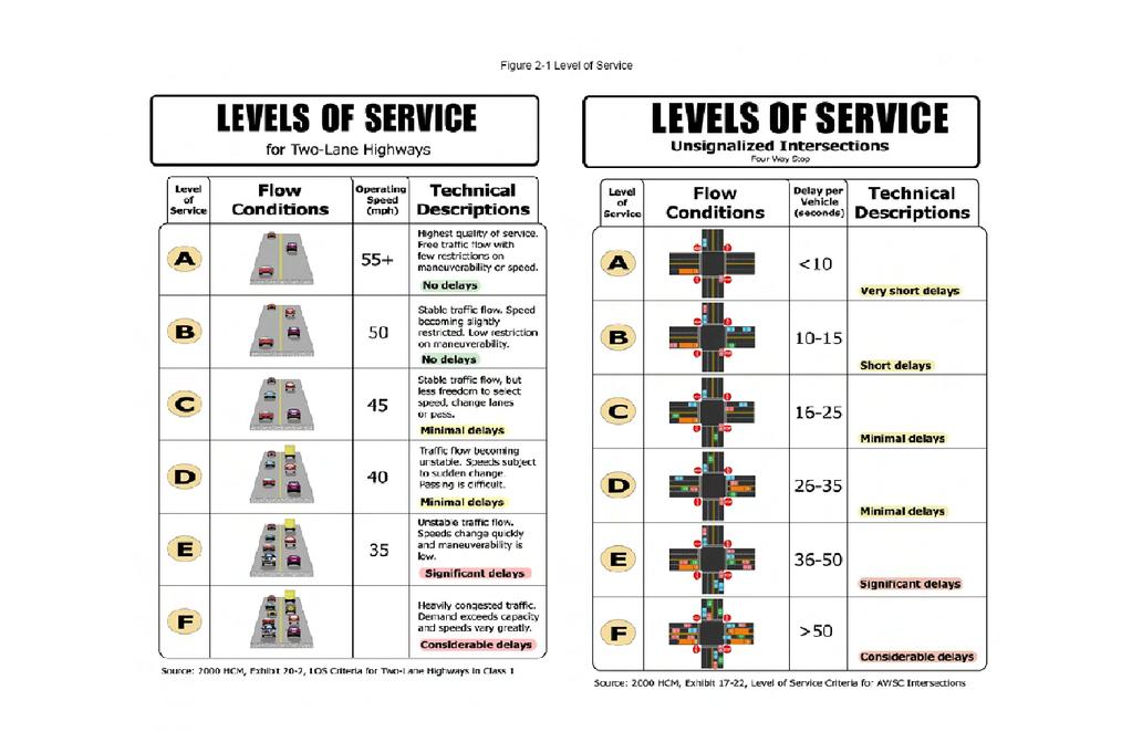
3 LEVEL OF SERVICE Level of service (LOS) is a standard measure of traffic service along a roadway or at an intersection. It ranges from A to F, with LOS A being best and LOS F being worst. Figure 2-1 provides illustrations of Level of Service conditions for two types of roadway situations commonly found in Stanislaus County (i.e., two-lane highways and unsignalized intersections at four-way stops). In very general terms, LOS A, B and C indicate conditions where traffic can move relatively freely. LOS D describes conditions where delay is more noticeable and average travel speeds are more unstable. LOS E indicates significant delays and average travel speeds vary greatly and are unpredictable; traffic volumes are generally at or close to capacity. Finally, LOS F characterizes traffic flow at very slow speeds (stop-and-go) and significant delays with queuing at unsignalized intersections; in effect, traffic demand on the roadway exceeds the roadway's capacity. As a matter of policy, Stanislaus County strives to maintain LOS C or better on all roadways. When measuring levels of service, Stanislaus County uses the criteria established in the Highway Capacity Manual published and updated by the Transportation Research Board. TRAFFIC ANALYSIS To confirm the need for transportation improvements identified in the Circulation Element, a forecast of traffic volumes and Level of Service is prepared based upon the level of growth anticipated by the year 2030, the planning horizon for the General Plan. The forecast is based on the latest population, housing and employment projections prepared by StanCOG, the agency designated by the State to prepare these forecasts. These forecasts were adjusted to reflect additional growth anticipated by the cities or the County since the adoption of the StanCOG forecast. The traffic study is provided in Chapter 2 of the "Stanislaus County General Plan - Support Documentation" and its recommendations have been incorporated into this element. 2-3
4 THIS PAGE INTENTIONALLY LEFT BLANK 2-4
5 2-5
6 THIS PAGE INTENTIONALLY LEFT BLANK 2-6
7 STREETS AND ROADS Road Classifications A hierarchy of adequately sized roads will be required to provide access to facilitate the movement of people and goods throughout the County, provide access to future development within the unincorporated area and between cities, and maintain acceptable levels of service. The General Plan Circulation Diagram depicted in Figure 2-2 identifies the functional classification of key routes and distinguishes between existing and proposed future roads. The classifications as well as their required design and access standards are defined in the following index of road classifications (State Highways, and special circumstances and exceptions to these standards are noted in italics): A. Freeway. The function of a Freeway is to provide for the safe and efficient movement of large volumes of interregional, inter-city, and urban traffic at high-speeds. Freeways have no direct land service function. Access is restricted to roads via interchanges, and typically to Expressways and Majors. Parking is not permitted on freeways. Freeways in Stanislaus County are typically planned, constructed, and operated by Caltrans. Interstate 5 and State Route 99 are the only Freeways that traverse Stanislaus County. Caltrans has prepared a feasibility study to expand State Route 99 to eight lanes through the county. Right-of-way and building setback requirements for these facilities are determined by Caltrans. B. Expressway. The function of an Expressway is to move high volumes of people and goods between urban areas within the county at higher speeds depending upon the level of access control. Direct access to abutting property is specified within the standard for each expressway class. Expressways serve a similar function to that of Freeways - the fast and safe movement of people and goods within the county - and provide access to the interregional freeway system. On-street parking is not permitted on Expressways except under very special and rare circumstances where the Department of Public Works has determined that traffic flow and safety conditions allow on-street parking. The design features of Expressways are determined by the level of access control and the number of lanes designated for each expressway route segment (see Figure 2-3): (1) A Class A Expressway is a fully access-controlled road with grade separated interchanges at intervals of approximately one mile at other Expressway, Major, or Local roads. The typical right-of-way is 110 or 135 feet (4 or 6 lanes, respectively). State Route 120 (Oakdale Bypass from Valley Home Rd. to its eastern junction at State Route 108) is planned to be a Class A Expressway within the right-of-way planned and approved by Caltrans. (2) A Class B Expressway is a partially access-controlled road with traffic-controlled intersections at Major roads and other Expressways. Collectors and Locals are permitted right-in, right-out access only at 1/4- to 1/2-mile intervals. The typical right-of-way is 110 or 135 feet (4 or 6 lanes, respectively). On limited rights-of-way, Class B Expressways may be 100 feet for four lanes and 124 for six lanes. 2-7
8 State Route 219 (Kiernan Avenue between State Route 99 and State Route 108 (McHenry Blvd.) is planned to be a Class B Expressway. Caltrans has adopted an Official Plan Line for construction of the ultimate 6-lane facility. State Route 132 from State Route 99 west to the San Joaquin County line is planned to be constructed along a new alignment as a Class B Expressway unless otherwise determined by Caltrans. Caltrans has adopted Project Study Reports for construction of the interim facilities. (3) A Class C Expressway is a limited access-controlled road with traffic-controlled intersections at Majors and other Expressways. Intersections at Collectors and Locals may or may not be controlled by a traffic signal. The typical right-of-way is 110 or 135 feet (4 or 6 lanes, respectively). On limited rights-of-way, Class C Expressways may be 100 feet for four lanes and 124 for six lanes. Some State Highways that lie in the unincorporated area outside the spheres of influence of the cities and the community of La Grange (State Routes 4, 33, 120 except the Oakdale Bypass, and 132 along its existing Maze Blvd. alignment and east of Modesto) are planned to be Class C Expressways, unless otherwise determined by Caltrans. Santa Fe Avenue, outside of the communities of Empire and Denair, and the City of Hughson, is planned to be an 4-lane Class C Expressway within an 85-foot rightof-way measured from the railroad right-of-way. C. Major. The function of a Major road is to carry moderate- to high-volume traffic to and from collectors to other Majors, Expressways, and Freeways with a secondary function of land access. Majors located within areas zoned for heavy or light industrial or that are expected to carry large or heavy trucks shall be constructed to Industrial Major standards. Limited direct access is provided to abutting property. On-street parking will be permitted only where the Department of Public Works has determined that traffic flow and safety conditions allow on-street parking. The typical right-of-way is 110 feet (up to 6 lanes, ultimately). On limited rights-of-way, Majors may be 100 feet. State Routes 108 and 165 from State Route 99 to the Merced County line are planned to be Majors and State Route 33 within the cities of Patterson and Newman is planned to be an 80-foot Major, unless otherwise determined by Caltrans. Santa Fe Avenue, within the communities of Empire and Denair, and within the City of Hughson, is planned to be an 85-foot Major measured from the railroad right-of-way. D. Collector. Collectors serve a dual function by providing both access to abutting property and movement of moderate volumes of people and goods for medium length trips. Collectors serve as transition facilities, carrying traffic from lower to higher level roads. Most Collectors are two-lane roads with a typical right-of-way of 60 feet. On-street parking will be permitted only where the Department of Public Works has determined that traffic flow and safety conditions allow on-street parking. In urban residential subdivisions, roads not shown on the General Plan Circulation Diagram or as an Official Plan Line that will serve more than 50 dwelling units, when the maximum density and full extent of the development is considered, shall be deemed Collectors. In some instances, the Department of Public 2-8
9 Works may determine that project design features dictate that a road serving as few as 20 urban dwelling units be deemed a Collector. Under certain circumstances, 80 feet of rightof-way may be required to provide additional capacity to provide two additional through lanes to accommodate projected traffic demand, to facilitate the movement of large trucks, or to improve safety due to limited visibility or other safety hazards. Table 2-1 lists the 80-foot Collectors. E. Local. Local roads serve as land access facilities in the agricultural areas of the County by providing both direct access to abutting property and movement of small volumes of people and goods for medium length trips. Locals are two-lane roads with a typical right-of-way of 60 feet to safely accommodate drainage, utilities, and other physical improvements that may be located within the public right-of-way. In agricultural areas of the county, roads not shown on the General Plan Circulation Diagram or as an Official Plan Line shall be considered Locals. This classification also includes cul-de-sac and dead-end roads in agricultural areas of the county. F. Minor. Minor roads serve as land access facilities in the urban and industrial areas of the County by providing both access to abutting property and movement of small volumes of people and goods for short trips. In urban subdivisions, roads not shown on the General Plan Circulation Diagram or as an Official Plan LIne, which will serve no more than 50 dwelling units, when the neighborhood is fully developed, shall be deemed Minors unless otherwise designated by the Department of Public Works. Minor roads are two-lane roads with a typical right-of-way of 50 feet. Minors located within areas zoned for heavy or light industrial or which are expected to carry large or heavy trucks shall be constructed to Industrial Minor standards with a typical right-of-way of 70 feet. This classification also includes cul-de-sac and dead-end roads in urban and industrial areas of the County. G. Private. Private roads serve as land access facilities and are not maintained by the County. Two types of Private roads are permitted in the County. These roads are generally not shown on the General Plan Circulation Diagram. Agricultural access easements, providing access to parcels 20 acres or more, are included primarily to conform to state-mandated standards for private access roads in the State Responsibility Area as designated by the California Department of Forestry and Fire Protection. New roads under this category shall not exceed a 12% slope nor be less than 30 feet in width. Private roads may also be approved by the Planning Commission or Board of Supervisors as an exception to the Subdivision Ordinance to provide access to parcels in an urban or planned development when it is determined that such a request serves a public purpose and that future divisions of land requiring road access to or through the development would not occur due to topographic features, physical barriers, existing development, and other physical constraints of the development and the adjacent lands. If approved, these roads shall be constructed to the same standards as County-maintained roads or other standard approved by the Department of Public Works. Within the Spheres of Influence of any city, roadway improvements, dedications, building setbacks, and road reservations shall meet the development standards of the city consistent with the Spheres of Influence Policy in the Land Use Element of the General Plan, except in those areas subject to an individual city/county agreement. These requirements may change from time-to-time through 2-9
10 the adoption or revision of local land use plans or standards. To ensure consistency with a city s development standards, additional right-of-way may be required for each of the roadway classifications described above. Where design and access requirements of a city differ from those established by the County, development shall be required to meet the standards of the city. The County will consult with the city prior to the construction of transportation improvements within its sphere of influence to ensure consistency with the standards of that city. Dedication Requirements When land is subdivided or otherwise divided into smaller parcels in Stanislaus County, or when buildings are constructed, existing zoning and subdivision regulations provide for the dedication of land for eventual public road use within or adjacent to the development. It is required that sufficient land be dedicated to provide the width necessary for the ultimate road right-of-way based on the road classification of specific street plans. This dedication is based on the presumption that development will intensify use of the property and of the streets which provide access thereto. Findings must be made by the Planning Commission and the Board of Supervisors supporting this presumption when a subdivision application is being considered. Funds for the acquisition of road right-of-way are derived from several sources. Typical of these sources is Highway Users Tax Funds, transportation funds from sales tax, fines, bonds, the County General Fund, and earned interest. Since these funds are used for maintenance and replacement, as well as for the acquisition of right-of-ways, any money utilized for the acquisition of road right-of-ways in new developments will decrease the amount of money available for the maintenance and construction of the County road system elsewhere. Road right-of-way acquisition policies in new developments encompass the possibility of further development beyond these particular pieces of property and usually require the provision of road right-of-ways through the property to adjoining property in order to provide access in the future. Policy One of Goal One addresses dedication requirements. 2-10
11 MILNES LADD BECKWITH <=² SONORA 26 MILE ROAD SIERRA WILLMS PATTERSON MC HENRY <=D PARKER CLARIBEL HAMMETT YOSEMITE FUTURE HWY 132 PARADISE HICKMAN GRAYSON KEYES GRATTON FAITH HOME CROWS LANDING CARPENTER SHILOH WEST MAIN CENTRAL MARSHALL RIVER FINK STUHR <=Ç <=Ê <=I <=I <=D <=y <=Q VALLEY HOME <=I OAKDALE WATERFORD HWY LA GRANGE DRAPER <=Ê 123X HOWARD # <=] <=] <=] DAKOTA MILTON LAKE WHITMORE MONTPELIER SERVICE KEYES EAST 123X (Interim Options) HILLS FERRY LAS PALMAS PATTERSON BRADBURY WASHINGTON NEWMAN MODESTO RIVERBANK CERES OAKDALE # TURLOCK HUGHSON WATERFORD Figure 2-2 CIRCULATION DIAGRAM including Mitigation Measures (GPA adopted on April 18, 2006) Spheres of Influence City Boundary Rivers Roadway Classification FREEWAY EXPRESSWAY 6-LANE EXPRESSWAY 4-LANE MAJOR COLLECTOR MAJOR 6-LANE 4-LANE LOCAL 2-11 RIVER MC CRACKEN
12 THIS PAGE INTENTIONALLY LEFT BLANK 2-12
13 MILNES LADD BECKWITH <=² SONORA 26 MILE ROAD SIERRA WILLMS PATTERSON MC HENRY <=D PARKER CLARIBEL HAMMETT YOSEMITE FUTURE HWY 132 PARADISE HICKMAN GRAYSON KEYES GRATTON FAITH HOME CROWS LANDING CARPENTER SHILOH WEST MAIN CENTRAL MARSHALL RIVER FINK STUHR <=Ç <=Ê <=I <=I <=D <=y <=Q VALLEY HOME <=I OAKDALE WATERFORD HWY LA GRANGE DRAPER <=Ê 123X HOWARD # <=] <=] <=] DAKOTA MILTON LAKE WHITMORE MONTPELIER SERVICE KEYES EAST 123X (Interim Options) HILLS FERRY LAS PALMAS PATTERSON BRADBURY WASHINGTON NEWMAN MODESTO RIVERBANK CERES OAKDALE # HUGHSON TURLOCK WATERFORD Figure 2-3 CIRCULATION DIAGRAM (GPA adopted on April 18, 2006) Spheres of Influence City Boundary Expressway Access Class Class A Class B Class C 2-13 RIVER MC CRACKEN
14 THIS PAGE INTENTIONALLY LEFT BLANK 2-14
15 Table 2-1 Collector Routes Requiring at Least 80' of Right-of-Way* The following designated collector routes require at least 80' of right-of-way either because of hilly terrains or greater than average anticipated traffic flows: 1. Claribel Road: Oakdale-Waterford Highway to Tim Bell Road. 2. Cooperstown Road: Warnerville Road to La Grange Road. 3. Crabtree Road: Highway 132 to Warnerville Road. 4. Del Puerto Canyon Road: Interstate 5 to Santa Clara County. 5. Dunton Road: Milton Road to Highway Eastman Road: 26 Mile Road to 28 Mile Road. 7. Emery Road: Warnerville Road to Fogarty Road. 8. Fogarty Road: Wamble Road to Emery Road. 9. Frankenheimer Road: 28 Mile Road to Sonora Road. 10. Hawkins Road: Lake Road to Keyes Road. 11. Hazeldean Road: Highway 132 to Tim Bell Road. 12. Hickman Road: East Avenue to Whitmore Avenue. 13. Kennedy Road: Highway 108/120 to Sonora Road. 14. Keyes Road: Santa Fe Avenue to Merced County Line. 15. Lake Road: Hickman Road to Highway Lancaster Road: Orange Blossom Road to Highway 108/ Milnes Road: Claus to Oakdale-Waterford Highway. 18. Milton Road: Highway 4 to Calaveras County Line. 19. Orange Blossom Road: Highway 108/120 to Sonora Road. 20. River Road: San Joaquin County Line to Highway Rock River Road: Willms Road to Tuolumne County Line. 22. Rodden Road: Highway 120 to Orange Blossom Road. 23. Sisk Road: Kiernan Avenue north to end. 24. Sonora Road: Milton Road to Highway 108/ Tim Bell Road: Lone Oak Road to Warnerville Road. 26. Twenty Eight Mile Road: Rodden Road to Sonora Road. 27. Wamble Road: Fogarty Road to Orange Blossom Road. 28. Warnerville Road: Albers Road to Cooperstown Road. 29. Willms Road: Cooperstown Road to Highway 108/120. * This list only contains those Collector roads that require 80 feet of right-of-way. All other Collector routes are depicted in the Circulation Diagram depicted in Figure
16 Recommended Approach Lanes Additional lanes may be necessary at intersections to accommodate traffic making left-and rightturns. The recommended approach lane design at each intersection along these roadways is represented in Table 2-2. Precise intersection geometrics can be found in the Stanislaus County Department of Public Works Standards and Specifications. These geometrics will be used when establishing building setbacks and dedication requirements for development projects located in and around intersections, and may be modified in specific cases where the traffic impact analysis shows that additional approach lanes are needed to accommodate projected traffic. Official Plan Lines Official Plan Lines have been prepared for a number of roads in the County and adopted by the Board of Supervisors. Adoption of Official Plan Lines shows the intent of the County to widen these streets to a specified width along a specified alignment or build a new road at some future time. Official Plan Lines are often used when it is undesirable or impractical to widen a road by requiring legal dedication on both sides of the existing center line. Official Plan Lines are established to prevent any unnecessary removal of buildings or important natural features when the County is ready to build the road. Once adopted, building activity is prohibited inside the established setback lines although existing buildings may remain. Identified ultimate road widths and alignments for the eventual widening or construction of a road have the important advantage of minimizing the cost to the County in the future. If new structures are permitted to be constructed in the proposed right-of-way, the County will be obligated to purchase portions of buildings and land lying within the proposed street line. It is also hoped that the disruption and dislocation of privately- owned improvements would also be minimized to reduce impacts on property owners. Adoption of Official Plan Lines or identification of ultimate street width requires foresight because the entire process of developing a transportation corridor is a slow one. A number of years may elapse before the last building, or even a majority of the buildings, are set back to the adopted line. Building setbacks may cause hardships to the first buildings that are required to be set back of the new line because they appear to be placed at the back of a parcel with old buildings projecting in front of them on both sides. The process of adopting an Official Plan Line entails extensive technical studies and public outreach including a traffic analysis, environmental analysis, and detailed engineering studies to determine potential alignments and work with the affected property owners and the public to determine an appropriate alignment for each roadway. The Official Plan Lines adopted by the Board of Supervisors are listed in the Table 2-3. Some portions of these roads have been annexed into the spheres of influence or jurisdictional boundaries of the cities; therefore, city standards now apply to in those areas. This element includes proposed streets and roads that are necessary to support development planned within the cities general plans. Generally, these streets and roads will be planned, developed and constructed upon annexation to the city. If, however, a city develops an Official Plan Line for any of these roadways, the city may also wish to submit that Official Plan Line to the County for adoption to ensure it is applied to new development within the sphere of influence. 2-16
17 Table 2-2 RECOMMENDED APPROACH LANES Facility Type Intersecting Road Left Through Right Expressway Expressway 2 2 or 3 1 Major* 2 2 or 3 1 Collector* 1 2 or 3 1 Local* 1 2 or 3 1 Minor/Private Major Expressway* 2 2 or 3 1 Major 2 2 or 3 1 Collector 1 2 or 3 1 Local 1 2 or 3 1 Minor/Private Collector Expressway* 1 1 or 2 1 Major 1 1 or 2 1 Collector 1 1 or 2 1 Local 1 1 or 2 1 Minor/Private 0 1 or 2 0 Local Expressway* 1 1 or 2 1 Major 1 1 or 2 1 Collector 1 1 or 2 1 Local 1 1 or 2 1 Minor/Private 1 1 or 2 1 Minor/Private Expressway Major Collector Local Minor/Private * When permitted, based on access policy for Expressway Class. 2-17
18 Table 2-3 ADOPTED PLAN LINES NAME FROM TO 26 Mile Road Dodds Road Sonora Road Blue Gum Avenue Morse Road North Ninth Street Briggsmore Avenue State Route 99 Claus Road Carpenter Road Crows Landing Road Whitmore Avenue Claus Road State Route 132 State Route 108 Coffee Road Orangeburg Avenue Sylvan Road Coffee Road Sylvan Road Patterson Road Crane Road Patterson Road West F Street Crows Landing State Route 99 Whitmore Avenue Crows Landing Whitmore Avenue West Main Street Fink Road Interstate 5 State Route 33 Fulkerth Avenue State Route 99 Golden State Boulevard Hatch Road Carpenter Road Crows Landing Road Hatch Road State Route 99 Mitchell Road Hawkeye Road State Route 99 Berkeley Avenue Howard Road Interstate 5 State Route 33 McHenry-Ladd-Patterson Intersection Mc Henry Avenue Briggsmore Avenue Stanislaus River Monte Vista Avenue State Route 99 Berkeley Avenue Monte Vista Avenue State Route 99 Golden State Boulevard North Olive Avenue Canal Drive Monte Vista Avenue Oakdale Road Scenic Drive Patterson Road Orange Blossom Road Rodden Road Knights Ferry Paradise Road Sutter Avenue Dunning Lane Pelandale-Claratina Dale Road Claus Road Roselle Avenue Briggsmore Avenue Floyd Avenue Scenic Drive Modesto City Limit Claus Road Sperry Road Interstate 5 State Route 33 Standiford-Sylvan State Route 99 Claus Road Stearns Road State Route 108 Oakhurst Drive Stuhr Road Interstate 5 State Route 33 Sylvan-Standiford Avenue State Route 99 Claus Road Yosemite Boulevard Modesto City Limit W aterford City Limit Zeering Road State Route 99 Hawthorne Street 2-18
19 Study Areas Prior to adopting an Official Plan Line, focused traffic, engineering and environmental studies may be conducted to determine the appropriate alignment and right-of-way requirements for major transportation improvements. These studies are particularly useful when a new road is required or special circumstances, such as limited sight visibility or hilly terrain, warrant a more detailed traffic operations analysis to determine the appropriate design and alignment for the future facility. These studies will require extensive involvement by the cities, other public agencies, and the public, to determine the appropriate design and alignment of each facility. Eight special study areas have been identified as shown in Table 2-4. STUDY AREA Table 2-4 SPECIAL STUDY AREAS DESCRIPTION FROM TO SOURCE 1 Las Palmas Bypass Patterson San Joaquin River 2 Southeast Turlock Interchange Turlock Merced County Line StanCOG/Patterson Turlock 3 Washington Road Extension Turlock Keyes Turlock 4 Dakota Avenue/Service Road (Tuolumne River Crossing) 5 North County Transportation Corridor Paradise Road Service Road Modesto/Ceres State Route 99 East of Oakdale StanCOG 6 Briggsmore Avenue Extension Briggsmore Avenue Milnes Road StanCOG/Modesto 7 State Route 132 Realignment and Widening East of Empire San Joaquin County Line StanCOG 8 Claus/Garner/Faith Home Expressway Modesto Keyes StanCOG 9 SR-99/Kiernan Avenue Salida County Project Study Report 10 SR-99/Hammett Road Salida County Project Study Report Las Palmas Bypass: The Las Palmas Bypass (or Orange Avenue Extension) would provide a new connection from Sperry Road in Patterson to Las Palmas Avenue just west of the San Joaquin River. This project is planned to alleviate congestion along the Las Palmas corridor as proposed in the City of Patterson General Plan. 2-19
20 Southeast Turlock Interchange: The Southeast Turlock interchange is a study funded by a special federal grant to the City of Turlock and County of Merced. A joint planning study is underway to examine the potential realignment of State Route 165 to provide a bypass for the community of Hilmar that would connect to a new State Route 99 interchange in the southeast Turlock area which is required to support future planned development in the City of Turlock General Plan. Washington Road Extension: The Washington Road Extension would examine the possibility of extending the proposed expressway along Washington Road in the Turlock area to connect at the State Route 99 interchange at Keyes Road, rather than at the Taylor Road interchange. The purpose of the new connection is to reduce conflicts between large trucks and passenger vehicles. Dakota Avenue/Service Road River Crossing: To implement the expressway system proposed in the general plans of the cities of Modesto and Ceres an Official Plan Line will need to be adopted for the north-south expressway proposed along the Dakota Avenue alignment crossing the Tuolumne River and connecting to Service Road in the Ceres area. North County Transportation Corridor: The North County Transportation Corridor is a concept to construct an expressway from State Route 99 in the Salida area to a point east of Oakdale, perhaps at the same location that the new State Route 120 (otherwise known as the Oakdale Bypass) would connect to existing State Route 108/120. StanCOG has initiated a planning effort that will examine potential alignments and facility types within approximately one mile of the Kiernan Avenue and Claribel Road corridors through the Modesto, Riverbank and Oakdale areas. Briggsmore Avenue Extension: To implement the expressway system proposed in the City of Modesto General Plan, an extension of the Briggsmore Avenue expressway is planned from east of Claus Road along an alignment parallel and extending from MID Lateral No. 3 to Milnes Road. State Route 132 Realignment and Widening: Realignment, widening, and operational improvements along the State Route 132 corridor from Empire to the San Joaquin County Line have been planned for many years. A federal grant has been secured to investigate ways to connect the portion of State Route 132 east of State Route 99 to its new proposed alignment south of, and parallel to, Kansas Avenue west of State Route 99. Project Study Reports have been prepared by Caltrans for the construction of an expressway west of State Route 99 to Interstate 580. Claus/Garner/Faith Home Expressway: The general plans of the cities of Modesto and Ceres plan for the construction of an expressway and new Tuolumne River crossing along the Claus Road, Garner road, and Faith Home Road corridors from north Modesto to Keyes Road in the Keyes area. A Project Study Report was initiated by StanCOG to develop an Official Plan Line for the route, to resolve internal circulation issues within the Beard Industrial Tract, and determine the best engineering solution to cross the Tuolumne River in this area. State Route 99/Kiernan Avenue Interchange: The County has initiated a Project Study Report to determine potential improvements required to support implementation of the Salida Community Plan. State Route 99/Hammett Road Interchange: The County has initiated a Project Study Report to determine potential improvements required to support implementation of the Salida Community Plan. 2-20
21 Scenic Highways Section 65302(h) of the Government Code requires the general plan to include a Scenic Highways Element for the development, establishment, and protection of scenic highways pursuant to the provision of the Streets and Highways Code. Interstate 5 is the only officially designated State Scenic Highway in Stanislaus County. Standards for official designation of scenic highway rest on the analysis, planning, and protection of the scenic corridor through which the highway traverses. Although the emphasis of the scenic highway is on the designation of state highway routes as scenic routes, this does not preclude local agencies from developing and adopting local scenic designations on County routes. The Scenic Highway designation is an overlay and not a separate street classification. The scenic highway designation maintains areas which are in their natural or undeveloped condition. The State of California has designated various state highways as having natural scenic beauty worthy of preservation. This highway designation involves land use controls within the corridor to maintain the natural beauty of the area. Highway 99 Visual Enhancement Efforts While the primary function of the County s transportation network is to move people and goods from one place to another, each time someone travels on Stanislaus County s roads, they see a view of the community, whether it is from the window of a car, truck, bus or train, or from the seat of a bicycle. Whether for business or pleasure, these images gathered while traveling through the community affect perceptions and feelings about the community. A collaborative effort led by the Great Valley Center is raising awareness about ways communities can enhance the visual quality of major transportation corridors, in particular the Highway 99 corridor, and key gateways into communities located along major transportation corridors. To facilitate implementation of this effort, Caltrans adopted a master plan that provides examples of the types of improvements that can be made on Highway 99 that will not only improve the appearance of the corridor but meet State Highway design standards. The Stanislaus Council of Governments initiated a master planning effort for the Highway 99 corridor involving the cities of Turlock, Ceres, and Modesto, and the County of Stanislaus. These planning efforts provide suggestions and strategies on how transportation improvement projects, as well as development projects located on or within the view shed of the Highway 99 corridor, can be designed to improve the attractiveness of the corridor and help promote economic development, encourage tourism, highlight our natural resources, and generally improve the quality of the life in the county. BICYCLE AND PEDESTRIAN Stanislaus County offers excellent conditions for bicycle and pedestrian transportation. The County is generally flat, has a temperate climate, and major destinations are within an easy ride of most residences. According to the 2000 Census, approximately 3.1% of the workers reported that they rode a bike or walked to work regularly. Relatively few marked bicycle facilities have been constructed in the County. In agricultural areas, the County provides adequate striping and paving in accordance with Caltrans and AASHTO standards to safely accommodate bicycle travel whenever a roadway is widened, and, where adequate right-of-way exists, whenever a roadway is resurfaced, restored, or rehabilitated on all routes except Minor roads. Marked and/or signed bicycle lanes and paths are provided in accordance with the Regional Bicycle Action Plan adopted by StanCOG, the adopted Community Plans for the urban areas of the County, and the general plans of the cities within the spheres of influence. 2-21
22 PUBLIC TRANSIT Public transportation systems are being called upon to provide more services, serve more people and businesses, and satisfy more needs than ever before. Rising fuel costs, more stringent air quality regulations, and economic affordability are making transit a more attractive alternative for both commuters and local government. At the same time, public transit is being asked to deliver services more efficiently by reducing costs and to operate more effectively by targeting resources where people use them. Transit ridership continues to increase steadily, but accounts for only about one percent of the commute trips each day. Development patterns in the County, characterized by low housing densities and dispersed business centers, continue to make the Stanislaus area difficult to access and serve by public transit. The Stanislaus County Public Works Transit Division is the administrator for the County s intercity public transportation system, called Stanislaus Regional Transit or StaRT. StaRT provides service to sixteen (16) cities and communities in Stanislaus County and the city of Gustine in Merced County. StaRT operates fixed route, deviated fixed route, curb-to-curb dial-a-ride transportation services and provides non-emergency medical transportation to Bay area medical facilities. The Division has Memorandums of Understanding with three cities, Newman, Patterson and Waterford, to operate dial-a-ride services for their respective cities. Being the intercity operator, StaRT has connectivity with local transit operators and has transfer points within various cities, including Turlock, Ceres, Modesto, Riverbank and Oakdale. This enables County residents to connect between intracity and intercity transit so they can travel throughout the County. Transit services are supported through the construction and operation of bus maintenance facilities, shelters, benches and stop signs. Various planning activities are conducted by the County to ensure that transit services are provided in an efficient and effective manner. In October 2000, the County adopted a long-range transit plan that projects the long-term transit needs of the county and presents a vision for StaRT service. The County also prepares short-range transit plans covering a five-year period to look at improving coordination between operators and future transportation services to the University of California at Merced, Stanislaus County business parks and other locations within the County. The plan will also look at future capital purchases, including additional buses and transfer stations within key cities. RAIL SERVICE Passenger As an increasing number of commuters travel outside the County to jobs located in the Bay Area and Sacramento, the role of passenger rail service is changing. Traditionally, passenger rail service has met the travel needs of the recreational traveler. As time goes on, however, passenger rail is beginning to take on more importance as a commuter transportation option. The success of the Altamont Commuter Express from San Joaquin County to San Jose, funded largely through the passage of their half-cent sales tax, presents an alternative vision for the future role of passenger rail service in Stanislaus County. Presently, Stanislaus County has access to three passenger rail services - the Bay Area Rapid Transit system (BART), the Altamont-Commuter Express (ACE), and Amtrak. BART service can be accessed by traveling by car to the Dublin-Pleasanton station or taking the Modesto Area 2-22
23 Express (MAX) BART Express bus. ACE service can be accessed by traveling by car to the Lathrop/Manteca station or by taking inter-city bus service offered by the MAX ACE Express service. Depending on the destination, Amtrak service may be accessed locally at the Amtrak station on Parker Road or by traveling to stations located in the City of Stockton. In 2001, the County commissioned a study to examine potential alternatives to extend the ACE service to Stanislaus County. The study concluded that, with roughly fifteen percent (15%) of the passengers on ACE trains residing in Stanislaus County, passenger rail could work but would require a considerable infrastructure investment. The recommendations of this study should be reviewed and considered in future planning efforts. In 2003, the Bay Area Rapid Transit District (BART) began studying the feasibility of extending some type of service to connect Walnut Creek with Pleasanton, then eastward along the Interstate 580 corridor perhaps as far east as Tracy. Four different options are being considered using three different technologies, including light diesel multiple units, heavy diesel multiple units and bus rapid transit. High speed rail continues to be explored by the California High Speed Rail Authority as an alternative to driving and flying across the State. If implemented, this system would forever change the way people travel between cities and counties in California by offering an alternative to driving or flying. Studies suggest that roughly eighteen percent (18%) of the riders would come from the Central Valley. Freight Railroad operations in Stanislaus County include high speed mainline operations on the Burlington Northern and Santa Fe (BNSF) Railway and Union Pacific Railroad (UPRR) and low speed mainline and switching operations on the BNSF Railway, UPRR, Sierra Railroad, California Northern Railroad, Modesto and Empire Traction Company Railroad, and Tidewater Southern Railroad. Union Pacific Railroad (UPRR): The UPRR in Stanislaus County includes operations on the main line which passes through Salida, Modesto, Ceres, Keyes, and Turlock. The UPRR also operates on the California Northern Railroad line located on the west side of the county, which passes through Westley, Patterson, Crows Landing, and Newman. Burlington Northern and Santa Fe (BNSF) Railway: Operations on the BNSF Railway in Stanislaus County occur on the mainline which runs through Riverbank, Hughson, Empire, and Denair, and on a branch line which connects the mainline at Riverbank with the Sierra Railroad in Oakdale. Sierra Railroad: The Sierra Railroad operates between Oakdale and Standard, and includes both freight and passenger trains. Freight trains are operated by Union Pacific and Burlington Northern Santa Fe and usually operate roughly three times per week. Passenger trips travel between Oakdale and the eastern Stanislaus County Line and include entertainment style railroad travel approximately three to five times per week with most trips occurring Thursday through Sunday. Modesto and Empire Traction (M&ET) Company Railroad: The Modesto and Empire Traction Company is a short-line railroad which connects switching operations between the Union Pacific Railroad in Modesto and the Burlington Northern Santa Fe Railway in Empire. Train lengths can vary from one locomotive with four cars to up to several locomotives with 60 cars. 2-23
24 Tidewater Southern Railroad The Tidewater Southern Railroad is a branch line operation of the Union Pacific Railroad. The line runs in a general north-south route through Stanislaus County, from the City of Stockton to North Modesto and from the City of Turlock to South Modesto. The portion of the line from just south of Bangs Avenue through Modesto to Bonniefair was abandoned in 2000 and sections were removed or paved over in North of Bangs Road, operations typically occur three days per week on Tuesday, Thursday and Saturday. However, service may be operated more or less frequently depending on demand. Intermodal Transfer Facilities: Intermodal service is provided in the Beard Industrial District by the Valley Lift intermodal facility. AVIATION Air facilities in Stanislaus County serve a number of needs, including scheduled commercial air passenger service, recreational flights, military operations, agricultural crop dusting services, cargo services and private business flights. There are five major facilities of concern for circulation and transportation purposes: (1) Modesto City-County Airport (Harry Sham Field); (2) Oakdale Municipal Airport; (3) Turlock Airpark; (4) Crows Landing Air Facility; and (5) Patterson Airport. The Modesto-Stanislaus County Airport is currently the only airport that provides regularly scheduled air passenger service. The remaining air fields in the County are either private, not open to the public, or used purely for agricultural purposes. Air freight service is characterized by fast shipment of small bulk items or high value items over long distances at higher cost. For these reasons, air service does not account for a significant proportion of the tonnage of goods moved into and out of the region. A significant feature of air movement is its dependability and very short in-transit time. In many new businesses seeking to open new markets, and in businesses dealing in high value items, air shipment is an important means of providing rapid access to distant manufacturing facilities, and thereby eliminating large inventory requirements. In such cases, air shipment makes it possible to establish supply lines quickly and lowers the cost of maintaining inventory significantly. This offsets the higher cost of air service. In 2004, the County acquired title to1,528 acres of federal land formerly occupied by the Crows Landing Naval Air Station. The Crows Landing Air Facility served as an auxiliary landing field for the Moffett Air Field in Santa Clara County until 1991 when the Defense Base Realignment and Closure Commission voted to close the base. The property was transferred from the Navy to the National Space and Aeronautics Administration (NASA) in NASA continued to conduct aviation research and flight testing until Through special federal legislation, approved by Congress in 1999, NASA transferred the facility to the County for the expressed purpose of fostering economic development. These economic development opportunities have been explored by the County since 1989 with the adoption of the Stanislaus County Economic Strategic Plan. In 2001, the County adopted a Reuse Plan for the Crows Landing Air Facility that identified two distinct phases for development of the former base. Phase 1 would allow occasional fly-by s, touchand-go training, and other aviation exercises, along with agricultural crop production and ongoing environmental remediation activities required to transfer the remainder of the property to the County. Phase 2 would allow the development of General Aviation airport though an aviation permit application that must be approved by the Aeronautics Division of the California Department of Transportation. 2-24
NOTICE OF PREPARATION
 City of Ceres City of Hughson City of Modesto City of Newman City of Oakdale City of Patterson City of Riverbank City of Turlock City of Waterford County of Stanislaus Date: January 4, 2013 NOTICE OF PREPARATION
The federal congestion management process must include the following elements:
 Memorandum To: From: Re: STANCOG Kimley Horn, Jim Damkowitch STANCOG Federal Congestion Management Process Date: May 9, 2018 This memorandum provides documentation of StanCOG s Federal Congestion Management
SUPPLEMENTAL NOTICE OF PREPARATION OF AN ENVIRONMENTAL IMPACT REPORT. ACEforward Notice of Additional Project Element Niles Junction Connections
 SUPPLEMENTAL NOTICE OF PREPARATION OF AN ENVIRONMENTAL IMPACT REPORT DATE: May 9, 2016 FROM: TO: SUBJECT: San Joaquin Regional Rail Commission Agencies, Organizations, and Interested Parties ACEforward
CHAPTER 5: TRANSPORTATION
 CHAPTER 5: TRANSPORTATION GOAL 12: TRANSPORTATION BACKGROUND SUMMARY INTRODUCTION Albany s location and transportation facilities provide excellent advantages for commerce and economic development. Albany
Database and Travel Demand Model
 Database and Travel Demand Model 7 The CMP legislation requires every CMA, in consultation with the regional transportation planning agency (the Metropolitan Transportation Commission (MTC) in the Bay
CHAPTER 3.0 CIRCULATION ELEMENT
 CHAPTER 3.0 CIRCULATION ELEMENT The Circulation Element identifies the general location and extent of existing and proposed major transportation facilities for vehicle, rail, air, water, and bicycle transportation
TRANSPORTATION RELATIONSHIP TO OTHER ELEMENTS OF THE PLAN AND COUNTY REGULATIONS VISION FOR TRANSPORTATION PLANNING ROAD NETWORK SECTION 7
 TRANSPORTATION Like many growing western counties, Douglas County focuses on one of the most integral elements in land-use planning: transportation. The primary purpose of a transportation network is to
12 Evaluation of Alternatives
 12 Evaluation of Alternatives This chapter evaluates the effectiveness of the No-Build Alternative and the proposed METRO Blue Line Light Rail Transit (BLRT) Extension project based on the information
Transportation Facility Inventory
 CHAPTER 3 Transportation Element Section 3.1 Introduction Movement of people, goods, and services within and through the Town is an integral part of everyday life for the citizens of Hull. Decisions made
SCS Scenario Planning
 E SCS Scenario Planning Introduction As part of the 2035 MTP/SCS process, AMBAG developed a series of land use and transportation alternative scenarios for evaluation and testing to demonstrate how the
Transportation and Utilities
 4 Section 4 Transportation and Utilities 4.0 Introduction Transportation and utility systems are essential to accommodate and support development proposed in the Future Land Use Map. The following pages
CHAPTER 8 TRANSPORTATION ELEMENT
 CHAPTER 8 TRANSPORTATION ELEMENT Section 8.01 Purpose: The purpose of this Chapter (element) is to establish the desired and projected transportation system within Niceville and to plan for future motorized
CHAPTER 1 INTRODUCTION REGIONAL TRANSPORTATION PLAN/SUSTAINABLE COMMUNITIES STRATEGY
 CHAPTER 1 INTRODUCTION REGIONAL TRANSPORTATION PLAN/SUSTAINABLE COMMUNITIES STRATEGY CHAPTER 1 INTRODUCTION CREATING A SUSTAINABLE COMMUNITIES STRATEGY FOR THE SAN JOAQUIN REGION This chapter describes
TRANSPORTATION TRANSPORTATION 9-1
 TRANSPORTATION Community Vision 2028 Because we place such high value on our natural surroundings, we responsibly plan for, manage, and mitigate the impacts of growth on those surroundings. Kezziah Watkins
SECTION 5. Existing Conditions TRANSPORTATION NETWORK TRANSPORTATION
 SECTION 5 TRANSPORTATION Transportation systems are vital for moving people and goods and serving existing businesses. They also play a major role in guiding the location and type of development. The following
Chapter 9: Vision Plan. Chapter 9. Vision Plan. Lake Loveland. Image 179 Credit: City of Loveland
 Chapter 9 Vision Plan Lake Loveland. Image 179 Credit: City of Loveland Chapter 9: Vision Plan A. Regionally Significant Corridor and Regional Bike Corridor Visions Corridor visioning seeks to develop
Technical Memorandum 3 Executive Summary Existing Conditions and Constraints Presentation. March 22, 2006
 Technical Memorandum 3 Executive Summary Existing Conditions and Constraints Presentation March 22, 2006 MCGMAP Overview Develop a: Goods Movement Action Plan M A X I M I Z E S Mitigation of communities'
CROWS LANDING CORRIDOR PLAN
 ATTACHMENT 1: SCOPE OF WORK CROWS LANDING CORRIDOR PLAN INTRODUCTION: StanCOG proposes the Crows Landing Corridor Plan (Plan), which is needed to determine the feasibility of inter-jurisdictional transportation
Niagara s Transportation Strategy 1. Introduction:
 Niagara s Transportation Strategy May 8, 2002 Niagara s Transportation Strategy 1. Introduction: Transportation is of pivotal importance in the development of Niagara. This, Niagara s first comprehensive
Assessment of Current Status, Plans, and Preliminary Alternatives for High Capacity Transportation in the I-5 Corridor
 CONNECTING THURSTON COUNTY AND THE CENTRAL PUGET SOUND Alternatives to Meet Transportation Needs in the I-5 Corridor Working Paper #1 June 2011 Assessment of Current Status, Plans, and Preliminary Alternatives
Chapter 6 Freight Plan
 Chapter 6 Freight Plan Overview This chapter presents a review and assessment of needs, deficiencies, policies and improvement options affecting the freight transportation system within the Medford Urban
Traffic Impact Study Requirements
 [TYPE THE COMPANY NAME] Traffic Impact Study Requirements County of San Mateo Department of Public Works Roadway Services 9/1/2013 I. Introduction The County of San Mateo (County), Department of Public
6.0 CONGESTION HOT SPOT PROBLEM AND IMPROVEMENT TRAVEL DEMAND MODEL ANALYSIS
 6.0 CONGESTION HOT SPOT PROBLEM AND IMPROVEMENT TRAVEL DEMAND MODEL ANALYSIS 6.1 MODEL RUN SUMMARY NOTEBOOK The Model Run Summary Notebook (under separate cover) provides documentation of the multiple
4: Transportation and Land Use
 Chapter Figure 4-1: Recent development has brought more housing and mixed use Downtown Minneapolis - looking north from E 15th Street at the Grant Street / 11th Street exit 4: Transportation and Land Use
Chapter #9 TRAVEL DEMAND MODEL
 Chapter #9 TRAVEL DEMAND MODEL TABLE OF CONTENTS 9.0 Travel Demand Model...9-1 9.1 Introduction...9-1 9.2 Overview...9-1 9.2.1 Study Area...9-1 9.2.2 Travel Demand Modeling Process...9-3 9.3 The Memphis
ARROWS RANSPORTATION LAN
 ARROWS RANSPORTATION LAN Developed by the Transportation Planning Division Of the Virginia Department of Transportation In Cooperation With The U.S. Department Of Transportation, Federal Highway Administration
Central Valley Rail Working Group 1. INTRODUCTIONS
 CVRWG Meeting: February 24, 2017 Central Valley Rail Working Group 1. INTRODUCTIONS Central Valley Rail Working Group 2. SJJPA Update Dan Leavitt, SJJPA CVRWG Meeting: February 24, 2017 Morning Express
Chapter 4 NOISE ELEMENT
 Chapter 4 NOISE ELEMENT 1.0 INTRODUCTION 1.1 Authority The purpose of the noise element is to limit the exposure of the community to excessive noise levels. 1 The 2003 Noise Element Guidelines requires
Traffic Technical Memorandum: Hickman Road over Tuolumne River Bridge Replacement Project, Stanislaus County (BRLO-5938(199))
)") 11060 White Rock Road, Suite 200 Rancho Cordova, CA 95670 Phone: (916) 363-4210 Fax: (916) 363-4230 M e m o r a n d u m To: Reena Gohil, Environmental Planner Date: May 30, 2017 California Department of
11060 White Rock Road, Suite 200 Rancho Cordova, CA 95670 Phone: (916) 363-4210 Fax: (916) 363-4230 M e m o r a n d u m To: Reena Gohil, Environmental Planner Date: May 30, 2017 California Department of
Chapter 4: Transportation and Land Use
 Chapter 4: Transportation and Land Use Transportation and land use together make possible the wide range of destination opportunities in the region. Transportation provides the connections, and, in turn,
LAND USE POLICIES BY COMMUNITY DESIGNATION
 137 2040 138 Land Use Policies by Community Designation As discussed earlier in Thrive MSP 2040, the Council assigns a community designation to each city and township. This designation indicates the overall
3.0 TRANSPORTATION AND CIRCULATION
 3.1 INTRODUCTION LEGAL BASIS AND REQUIREMENTS Government Code Section 65302(b) establishes the legal requirements of a Circulation Element as: [The shall include] a Circulation Element consisting of the
Chapter 5 - Transportation
 Chapter 5 - Transportation Discussion Similar to the other elements in the Comprehensive Plan, the transportation element impacts the quality of life, economic development and public safety of the residents
Final Land Use and Development Opportunities Report 5.0 Environmental Impact/Environmental Consequences
 Figure 5-6. Century City 1/4-Mile Station Area August 16, 2010 Page 5-14 Figure 5-7. Wilshire/Westwood 1/4-Mile Station Area August 16, 2010 Page 5-15 Alternative 1 would be constructed underneath existing
INCREASING CAPACITY ON THE SAN JOAQUIN CORRIDOR A PUBLIC-PRIVATE PARTNERSHIP
 INCREASING CAPACITY ON THE SAN JOAQUIN CORRIDOR A PUBLIC-PRIVATE PARTNERSHIP Presented By Ken Galt, Caltrans Division of Rail John Fleming, Burlington Northern Santa Fe Railway William Brewster, Hanson-Wilson
Evaluation of Alternatives
 Chapter 9.0 Evaluation of Alternatives Chapter 9.0 provides a summary evaluation of the No Build Alternative and the Preferred Alternative. The evaluation contained within this chapter is an assessment
ELEMENT M GROWTH MANAGEMENT
 Growth Management ELEMENT M GROWTH MANAGEMENT GOAL: To ensure that growth and development are integrally planned with, and phased concurrently with, the City of Irvine s ability to provide an adequate
FLORIDA DEPARTMENT OF TRANSPORTATION PROCEDURE DEVELOPMENT OF THE
 FLORIDA DEPARTMENT OF TRANSPORTATION PROCEDURE DEVELOPMENT OF THE FLORIDA INTRASTATE HIGHWAY SYSTEM Topic No.: 525-030-250-f Office: Systems Planning Effective Date: May 16, 2002 DEVELOPMENT OF THE FLORIDA
CITY COUNCIL RESOLUTION NO. 02-
 CITY COUNCIL RESOLUTION NO. 02- A RESOLUTION OF THE CITY COUNCIL OF THE CITY OF IRVINE APPROVING GENERAL PLAN AMENDMENT 48403-GA TO AMEND TABLE A-1 MAXIMUM INTENSITY STANDARDS BY PLANNING AREA AND TABLE
POLK COUNTY TPO Polk County 2060 Transportation Vision Plan Final Report. ADOPTED June 18, 2009
 POLK COUNTY TPO Polk County 2060 Transportation Vision Plan Final Report ADOPTED June 18, 2009 TABLE OF CONTENTS CHAPTER 1 Introduction and Prior Planning Effort...Page 1-1 CHAPTER 2 Population and Employment
Chapter 3 Stakeholder Interviews and Summary of Needs
 Chapter 3 Stakeholder Interviews and Summary of Needs 42 CHAPTER 3 STAKEHOLDER INTERVIEWS AND SUMMARY OF NEEDS CHAPTER 3. STAKEHOLDER INTERVIEWS AND SUMMARY OF NEEDS An extensive stakeholder interview
Introduction. CHAPTER 2: Introduction 13
 02 Introduction CHAPTER 2: Introduction 13 14 2018 Draft Regional Transportation Plan/Sustainable Communities Strategy 2 INTRODUCTION The Stanislaus Council of Government s 2018 Regional Transportation
The following County planning and policy documents relate to or implement the Circulation, Infrastructure, and Services Element.
 Mariposa General Plan 9 CIRCULATION, INFRASTRUCTURE, AND SERVICES T his element identifies circulation and infrastructure needs in the County. The Element provides guidance for transportation and capital
Chapter 5 Transportation Draft
 Chapter 5 Transportation Draft Discussion Similar to the other elements in the Comprehensive Plan, the transportation element impacts the quality of life, economic development and public safety of the
GULF COAST RAIL DISTRICT VISION FOR REGIONAL RAIL
 GULF COAST RAIL DISTRICT VISION FOR REGIONAL RAIL OCTOBER 2014 Cover photographs courtesy of Top left - Mike Bates TABLE OF CONTENTS MISSION... 1 INTRODUCTION... 1 VISION STATEMENT... 1 BACKGROUND... 2
City of Menifee. Public Works Department. Traffic Impact Analysis Guidelines
 Public Works Department Traffic Impact Analysis Guidelines Revised: August 2015 TABLE OF CONTENTS INTRODUCTION... 3 PURPOSE... 3 EXEMPTIONS... 3 SCOPING... 4 METHODOLOGY... 5 STUDY AREA... 6 STUDY SCENARIOS...
Richard Clarke Executive Director Program Management. Capital Program Management
 Richard Clarke Executive Director Program Management Capital Program Management Department Overview > Transit, Highway Programs, and Regional Rail o Transit Deliver construction projects on-time and within
Chapter 3 - Goals, Objectives, & Strategies
 Chapter 3 - This chapter presents goals, objectives, and strategies that have been developed as part of the Richmond Area MPO 2026 Long-Range Transportation Plan (LRTP) update. Strategies have been developed
WHILE LOCAL COMMUNITIES MAY NOT BE ABLE TO DIRECTLY INFLUENCE THE EQUIPMENT USED ON NEARBY RAIL CORRIDORS, LOCAL COMMUNITIES
 WHILE LOCAL COMMUNITIES MAY NOT BE ABLE TO DIRECTLY INFLUENCE THE EQUIPMENT USED ON NEARBY RAIL CORRIDORS, LOCAL COMMUNITIES CAN TAKE STEPS TO REDUCE THE EXPOSURE OF LOCAL RESIDENTS TO LOCOMOTIVE EXHAUST.
NOISE TECHNICAL MEMORANDUM. Inland Rail Trail Project Cities of San Marcos and Vista, San Diego County DISTRICT 11 SD CML 5381(003)
") NOISE TECHNICAL MEMORANDUM Inland Rail Trail Project Cities of San Marcos and Vista, San Diego County DISTRICT 11 SD CML 5381(003) Attention: Kevin Hovey, Environmental Branch Chief, Caltrans District
NOISE TECHNICAL MEMORANDUM Inland Rail Trail Project Cities of San Marcos and Vista, San Diego County DISTRICT 11 SD CML 5381(003) Attention: Kevin Hovey, Environmental Branch Chief, Caltrans District
Frequently Asked Questions Connecting Palo Alto
 Frequently Asked Questions Connecting Palo Alto www.cityofpaloalto.org/connectingpaloalto General Project Questions Q1: What is Connecting Palo Alto? A1: Connecting Palo Alto (formerly the Palo Alto Rail
3. STATION SPACING AND SITING GUIDELINES
 3. STATION SPACING AND SITING GUIDELINES The station spacing and siting guidelines are summarized in Table 3-1. Table 3-1 also includes benchmark information for local transit service and express bus as
3.6 GROUND TRANSPORTATION
 3.6.1 Environmental Setting 3.6.1.1 Area of Influence The area of influence for ground transportation consists of the streets and intersections that could be affected by automobile or truck traffic to
SUBURBAN EDGE COMMUNITY ROLE COUNCIL ROLE ALL COMMUNITIES SUBURBAN EDGE
 Orderly and Efficient Land Use Align land use, development patterns, and infrastructure to make the best use of public and private investment. Plan and stage development for forecasted growth through 2040
Grottoes. Transportation Plan. Transportation Planning Division. Virginia Department of Transportation
 2020 Transportation Plan Developed by the Transportation Planning Division of the Virginia Department of Transportation in cooperation with the U.S. Department of Transportation, Federal Highway Administration
AB 758, as amended, Eggman. Transportation: Tri-Valley San Joaquin Valley Regional Rail Authority.
 AB 758, as amended, Eggman. Transportation: Tri-Valley San Joaquin Valley Regional Rail Authority. Existing law provides for the creation of statewide and local transportation agencies, which may be established
CHAPTER 2.0: INTRODUCTION
 CHAPTER 2.0: INTRODUCTION 2.1 INTRODUCTION The Federal Transit Administration (FTA) and the Santa Clara Valley Transportation Authority (VTA) have prepared this Environmental Impact Statement/Environmental
Lynnwood Link Extension 2013 Draft EIS Comments and Responses. Page 945
 I-441-001 Thank you for your comments about the importance of the Latvian Center to the Latvian community. Following the Draft EIS, the Sound Transit Board directed Sound Transit to develop a Preferred
Stockton Freight & Passenger Rail Mobility Enhancement
 Stockton Freight & Passenger Rail Mobility Enhancement 2017 $10.34 million in 2017 FASTLANE Grant funding to complete engineering design, permitting, and construction of the Stockton Track Extension and
Appendix D: Functional Classification Criteria and Characteristics, and MnDOT Access Guidance
 APPENDICES Appendix D: Functional Classification Criteria and Characteristics, and MnDOT Access Guidance D.1 Functional classification identifies the role a highway or street plays in the transportation
APPENDIX D ACCESS MANAGEMENT GUIDELINES
 APPENDIX D ACCESS MANAGEMENT GUIDELINES Access management has become an important tool in transportation planning. Access management guidelines are intended to preserve the integrity of roadways by balancing
Truck Management ` Strategies in Los Angeles
 Truck Management ` Strategies in Los Angeles Susan Bok, AICP Senior Transportation Planner Los Angeles Department of Transportation NACTO Chicago Workshop May 11-12, 2009 Context Population Downtown LA
4.9 TRANSPORTATION AND CIRCULATION
 4.9 TRANSPORTATION AND CIRCULATION 4.9 TRANSPORTATION AND CIRCULATION This section describes the current transportation setting for and generally assesses the impacts of future dairy development on the
6.2.2 Environmental Consequences and Mitigation Measures
 6.2 6.2.1 Introduction The existing conditions, regulatory setting, and methods of analysis for transportation under CEQA are described in Chapter 3, NEPA and CEQA Analysis. Impacts that would result from
EIGHT PLANNING FACTORS
 EIGHT PLANNING FACTORS Under the provisions of SAFETEA-LU, all Metropolitan Planning Organizations (MPOs) are required to consider eight (8) broad planning factors in the development of multi-modal transportation
Memorandum. FROM: Jim Ortbal Rosalynn Hughey Barry Ng TO: HONORABLE MAYOR, CITY COUNCIL. DATE: June 16, 2017
 CITY OF SANjOSE CAPITAL OF SILICON VALLEY TO: HONORABLE MAYOR, CITY COUNCIL SUBJECT: TRANSPORTATION POLICY UPDATE REQUIRED BY STATE LAW - LOS TO VMT Memorandum FROM: Jim Ortbal Rosalynn Hughey Barry Ng
Contents i Contents Page 1 A New Transportation Plan Community Involvement Goals and Objectives... 11
 Contents i Contents 1 A New Transportation Plan... 1 Why develop a new plan?... 1 What area does the LRTP focus on?... 2 Why is this LRTP important?... 3 Meeting Requirements for Transportation Planning...
Appendix O Congestion Management Program REGIONAL TRANSPORTATION PLAN/SUSTAINABLE COMMUNITIES STRATEGY
 Appendix O Congestion Management Program REGIONAL TRANSPORTATION PLAN/SUSTAINABLE COMMUNITIES STRATEGY 2014 REGIONAL CONGESTION MANAGEMENT PROGRAM 2014 RTP/SCS APPENDIX O SAN JOAQUIN COUNCIL OF GOVERNMENTS
Appendix D Functional Classification Criteria and Characteristics, and MnDOT Access Guidance
 Appendix D Functional Classification Criteria and Characteristics, and MnDOT Access Guidance Functional classification identifies the role a highway or street plays in the transportation system. Some highways
2004 FEASIBILITY STUDY UPDATE
 Austin-San Antonio Intermunicipal Commuter Rail District 2004 FEASIBILITY STUDY UPDATE December 2004 EXECUTIVE SUMMARY INTRODUCTION Almost 3 million people in Central Texas, living and working between
Mendocino Forest Products Grading For Industrial Land Improvements
 Mendocino Forest Products Grading For Industrial Land Improvements Technical Memorandum #10 CEQA Evaluation of Environmental Impacts Prepared for: Mendocino Forest Products Company, LLC Consulting Engineers
Woodlake General Plan Draft Environmental Impact Report
 5.0 UNAVOIDABLE ADVERSE ENVIRONMENTAL EFFECTS The following potential adverse environmental effects appear to be unavoidable if the Woodlake General Plan is implemented, even if certain mitigation measures
Patrick Prescott, Community Development Director By: David L. Kriske, Assistant Community Development Director
 DATE: April 26, 2016 TO: FROM: Ron Davis, Interim City Manager Patrick Prescott, Community Development Director By: David L. Kriske, Assistant Community Development Director SUBJECT: Modification of two
REGIONAL PLANNING AND POLICY FRAMEWORK A Preferred Approach for our Regional Growth
 REGIONAL PLANNING AND POLICY FRAMEWORK A Preferred Approach for our Regional Growth The Regional Comprehensive Plan (RCP) establishes a new approach to planning in the San Diego region. This approach is
2. Goals and Objectives
 Pedestrians in Charlotte s busy Uptown. CRTPO Mission The mission of the Charlotte Regional Transportation Planning Organization (CRTPO) is to plan for transportation options that ensure mobility, respect
MARION COUNTY COMPREHENSIVE PLAN 2035
 0 0 0 0 INTRODUCTION The Marion County Transportation Element Goals, Objectives and Policies are designed to provide a comprehensive, area-wide vision of Marion County s transportation systems and integration
The Policies section will also provide guidance and short range policies in order to accomplish the goals and objectives.
 4 Goals & Objectives INTRODUCTION The 2015-2040 MTP preserves and promotes the quality of life and economic prosperity of the MAB by providing a transportation system consistent with the regional goals.
APPENDIX A: Transportation Planning Rule
 A APPENDIX A: Transportation Planning Rule This appendix contains the full text of Oregon s Transportation Planning Rule (TPR). Transportation Planning Rule (TPR) NOTE: The official copy of an Oregon Administrative
Chapter 4. Recommendations
 Chapter 4 Recommendations Project Rating Methodology 1.0 Introduction This chapter outlines the prioritization of potential investments that were identified during this MIS process. During this study there
Once known as warehousing and distribution, the process
 Map III-2.3 Proposed Agile Port Industrial Area AGILE PORT INDUSTRIAL AREA PLAN Once known as warehousing and distribution, the process of moving goods to market has evolved dramatically. No longer is
SECTION 5: ALTERNATIVES TO THE PROPOSED PROJECT
 City of American Canyon Broadway District Specific Plan Alternatives to the Proposed Project SECTION 5: ALTERNATIVES TO THE PROPOSED PROJECT 5.1 Introduction In accordance with CEQA Guidelines Section
EXECUTIVE SUMMARY REGIONAL TRANSPORTATION PLAN 2050
 EXECUTIVE SUMMARY REGIONAL TRANSPORTATION PLAN 2050 Introduction Goals Policies, and Performance Measures Growth Forecast and Planned Land Use Development Key Recommendations i Executive Summary April
Chapter Five: Transportation
 Chapter Five: Transportation Purpose and Intent Transportation Goals and Policies Land Use Assumptions Airway Heights Transportation System Facilities and Services Pedestrian Transportation Public Transportation
Hawthorne, Mineral County Nevada And the Intermountain West Corridor I-11
 Presentation by Mineral County Planning Commission Mark Nixon, Chairman Hawthorne, Mineral County Nevada And the Intermountain West Corridor I-11 1 The Hawthorne town site was founded in 1881 as a diversion
5.0 PRELIMINARY ENVIRONMENTAL REVIEW
 5.0 PRELIMINARY ENVIRONMENTAL REVIEW 5.1 INTRODUCTION A preliminary environmental review was performed on the proposed freeway improvements that form Concept C, which encompasses the three freeway corridors
Northern Virginia Region Draft Needs Summary
 Needs Map: Need A A DEMAND The ability of communities around transit stations (particularly the areas within 1-2 miles of the stations and other travel hubs) to attract skilled workers and grow businesses
MEMORANDUM #4. DATE: November 4, Warrenton TSP Project Management Team. Ray Delahanty, AICP, DKS Associates Kate Petak, EIT, DKS Associates
 MEMORANDUM #4 DATE: November 4, 2015 TO: FROM: SUBJECT: Warrenton TSP Project Management Team Ray Delahanty, AICP, DKS Associates Kate Petak, EIT, DKS Associates Warrenton Transportation System Plan Update
APPENDIX B. Public Works and Development Engineering Services Division Guidelines for Traffic Impact Studies
 APPENDIX B Public Works and Development Engineering Services Division Guidelines for Traffic Impact Studies Revised December 7, 2010 via Resolution # 100991 Reformatted March 18, 2011 TABLE OF CONTENTS
APPENDIX N East King County Subarea High Capacity Transit (HCT) Analysis: Approach to Assessing System-Level Alternatives
 Analysis: Approach to Assessing System-Level Alternatives") Sound Transit Regional Transit Long-Range Plan Draft Supplemental Environmental Impact Statement APPENDIX N East King County Subarea High Capacity Transit (HCT) Analysis: Approach to Assessing System-Level
Sound Transit Regional Transit Long-Range Plan Draft Supplemental Environmental Impact Statement APPENDIX N East King County Subarea High Capacity Transit (HCT) Analysis: Approach to Assessing System-Level
Chapter One LAND USE ELEMENT INTRODUCTION
 Chapter One LAND USE ELEMENT INTRODUCTION The Land Use Element designates the type, intensity, and general distribution of uses of land for housing, business, industry, open space, agriculture, natural
GUIDE FOR THE PREPARATION OF TRAFFIC IMPACT STUDIES
 GUIDE FOR THE PREPARATION OF TRAFFIC IMPACT STUDIES Adopted by Town Council on November 25, 2008 Prepared By: HNTB Engineering Department Planning Department TABLE OF CONTENTS I. INTRODUCTION... 1 II.
RURAL CENTER COMMUNITY ROLE COUNCIL ROLE RURAL CENTER ALL COMMUNITIES
 Orderly and Efficient Land Use Align land use, development patterns, and infrastructure to make the best use of public and private investment. Plan for forecasted population and household growth at overall
Environmental Impact Statement for the Green Line to the Airport Project. ACTION: Notice of Intent to Prepare an Environmental Impact Statement (EIS).
.") This document is scheduled to be published in the Federal Register on 11/18/2015 and available online at http://federalregister.gov/a/2015-29418, and on FDsys.gov DEPARTMENT OF TRANSPORTATION Federal Transit
This document is scheduled to be published in the Federal Register on 11/18/2015 and available online at http://federalregister.gov/a/2015-29418, and on FDsys.gov DEPARTMENT OF TRANSPORTATION Federal Transit
Article 16 Traffic Impact Analysis
 Article 16 Traffic Impact Analysis Table of Contents... 16-1 Chapter 16.1 Purpose and Intent... 16-2 Chapter 16.2 Applicability... 16-2 Chapter 16.3 Exemptions... 16-2 Chapter 16.4 Trip Generation Data...
Rail Freight and Passenger
 Take Care of the System Critical Investments in the areas of: Rail Freight rehabilitate rail bridges o Rail Bridge Inventory Database... $0.5 - $1.0 million (one time) Rail Freight rail replacement and
Mobility 2025 Update: The Metropolitan Transportation Plan
 Mobility 2025 Update: The Metropolitan Transportation Plan May, 2001 North Central Texas Council of Governments Transportation Department MOBILITY 2025 UPDATE FINANCIAL SUMMARY Metropolitan Transportation
Section 3.11 Land Use
 Chapter 3 Affected Environment, Environmental Consequences, and Mitigation Measures Section 3.11 Land Use Introduction This section discusses the effect of the proposed alternatives on existing land use,
Appendix O Level of Service Standard and Measurements
 July 8, 2016 Appendix O. Appendix O Standard and Measurements Definition Level of service (LOS) is a mechanism used to determine how well a transportation facility is operating from a traveler s perspective.