LESA ASSESSMENT MOUNT SIGNAL SOLAR FARM I PROJECT AREA
|
|
|
- Muriel Russell
- 5 years ago
- Views:
Transcription
1 LESA ASSESSMENT MOUNT SIGNAL SOLAR FARM I PROJECT AREA MOUNT SIGNAL SOLAR FARM I PROJECT (SW/4 Section 16, S/2 Section 15, NE/4 Section 14 (portion), N/2 Section 13 (portion) and SE/4 Section 13, T17S, R13E, SBB&M; SE/4 Section 18 and N/2 Section 19 (portion), T17S, R14E, SBB&M) IMPERIAL COUNTY, CALIFORNIA April 2011 EMA Report No Prepared for: 82LV 8ME, LLC Santa Monica Boulevard, Suite 300 Los Angeles, California ENVIRONMENTAL MANAGEMENT ASSOCIATES
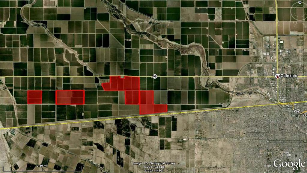
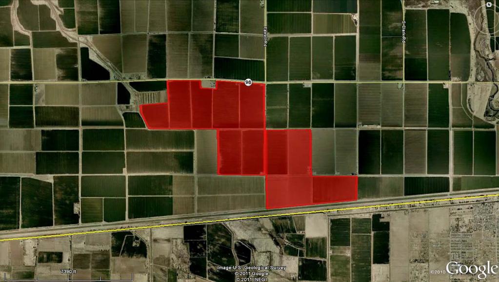
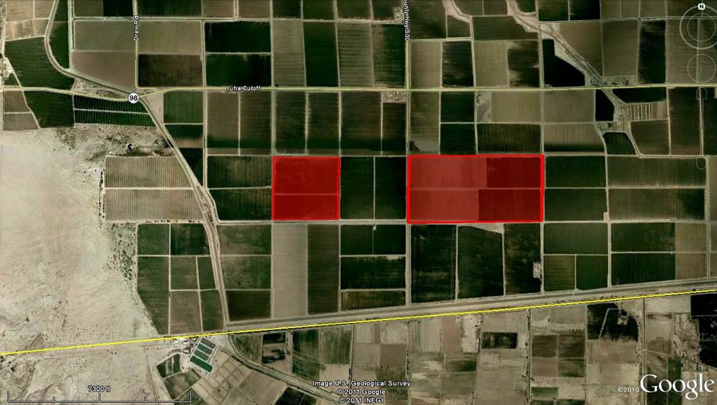
2 LAND EVALUATION AND SITE ASSESSMENT MODEL MOUNT SIGNAL SOLAR FARM I PROJECT (SW/4 Section 16, S/2 Section 15, NE/4 Section 14 (portion), N/2 Section 13 (portion) and SE/4 Section 13, T17S, R13E, SBB&M; SE/4 Section 18 and N/2 Section 19 (portion), T17S, R14E, SBB&M) IMPERIAL COUNTY, CALIFORNIA The Land Evaluation and Site Assessment (LESA) model is an approach for rating the relative quality of land resources based upon specific measurable features. The LESA model was first developed by the federal (NRCS) in It was subsequently adapted in 1990 by the California Department of Conservation to evaluate land use decisions that affect the conversion of agriculture lands in California. The formulation of the California LESA Model is intended to provide lead agencies under the California Environmental Quality Act (CEQA) with an optional methodology to ensure that significant effects on the environment of agricultural land conversions are quantitatively and consistently considered in the environmental review process. For determining the potential CEQA significance resulting from the conversion of agricultural lands to some other purpose, the California Agricultural LESA Model has developed Scoring Thresholds which are used to compare the Final LESA Score and the Weighted Factor Scores for the Project with suggested Scoring Decisions. These LESA Scores do not take into consideration any proposed mitigation measures or other factors that might affect a lead agency s determination of the significance of the agricultural lands conversion impact under CEQA. The information provided on the following pages present documentation of the LESA assessment prepared using the California Agricultural LESA Model for the proposed Mount Signal Solar Farm 1 Project (Project). The proposed Project would be constructed on four properties totaling approximately 1,432 acres of privately owned land located about 6.5 miles west of the city of Calexico, California (Figure 1). Project Area I (APN ; ; and ) is bounded on the north by Highway 98 and on the south by an unpaved Imperial County road (Anza Road). Project Area II (APN ; ; and ) is bounded on the west and east by unpaved Imperial County roads (Ferrell and Weed Roads, respectively)(figure 2). Project Area III (APN ) is bounded on the west, south and east by unpaved Imperial County roads (Brockman, Anza and Rockwood Roads, respectively). Project Area IV (APN ) is bounded on the west and south by unpaved Imperial County roads (Pulliam and Anza Roads, respectively) (Figure 3).
3 LESA ASSESSMENT 82LV 8ME, LLC MOUNT SIGNAL SOLAR FARM I PROJECT IMPERIAL COUNTY, NEVADA TABLE OF CONTENTS SUMMARY... i LIST OF FIGURES... ii LIST OF APPENDICES... ii 1. CALIFORNIA LAND EVALUATION AND SITE ASSESSMENT MODEL... 4 A LAND CAPABILITY CLASSIFICATION ( LCC )...4 B STORIE INDEX RATING...9 C PROJECT SIZE RATING...10 D WATER RESOURCES AVAILABILITY RATING...11 E SURROUNDING AGRICULTURAL LAND RATING...12 F SURROUNDING PROTECTED RESOURCE LAND RATING...12 G WEIGHTING OF FACTORS AND FINAL LESA SCORE...16 Page LIST OF FIGURES Figure 1: Location Map... 1 Figure 2: Project Area Map on an Aerial Photographic Base Area I & II... 2 Figure 3: Project Area Map on an Aerial Photographic Base Area III & IV... 3 Figure 4: Project Area Soils Map Area I... 5 Figure 5: Project Area Soils Map Area II... 6 Figure 6: Project Area Soils Map Area III... 7 Figure 7: Project Area Soils Map Area IV... 8 Figure 8: Zone of Influence Area I & II Figure 9: Zone of Influence Area III & IV Page LIST OF APPENDICES APPENDIX A: MOUNT SIGNAL SOLAR FARM I SOILS DETAILS
4
5
6
7 Land Evaluation Worksheet A B C D E F G H Soil Map Unit* Project Acres Proportion of LCC** LCC Rating LCC Score Storie Storie Index Project Area (irrigated) (irrigated)*** (C x E) Index** Score (C x G) IIw IIw IIIw IIIw IIIe IIs IIIw IIIw Totals LCC Total Storie Index 60 Score Total Score 54 Total Project Area (acres)= 1432 * The Soil Map Unit information and acreage were determined from the current soil survey information available at the USDA website: (Figure 4, Figure 5, Figure 6 and Figure 7). ** The Land Capability Classification and Storie Index information was obtained from the current soil survey information available at the USDA website: (Appendix A). *** The LCC Rating for irrigated land was determined from the LCC Point Rating Table 2 from the LESA Instruction Manual (California Department of Conservation 1997).


8 Adjusted to Acres Rounded Percentages

9 Adjusted to Rounded Percentages

10 Adjusted to Rounded Percentages

11 Adjusted to Rounded Percentages
12 Site Assessment Worksheet 1 Project Size Score* I J K LCC Class I-II LCC Class III LCC Class IV-VIII Project Acres per LCC Class Project Acres per LCC Class Project Acres per LCC Class Project Acres per LCC Class Project Acres per LCC Class 0.91 Total Project Acres per LCC Class * Project Size Scores Highest Project Size Score 100 * Project Size Score was determined from the Project Size Scoring Table from the LESA Instruction Manual (California Department of Conservation 1997).
13 A B C D E Project Portion Water Source Site Assessment Worksheet 2 Water Resources Availability Proportion of Project Area Water Availability Score* Weighted Availability Score (C x D) 1 Irrigation District Only Total Water (Must Sum to 1.0) 100 Resource Score * The Water Availability Score was determined using the Water Resources Availability Scoring Table from the LESA Instruction Manual (California Department of Conservation 1997).
14 Site Assessment Worksheet 3 Surrounding Agricultural Land & Surrounding Protected Resource Land A B C D E F G Zone of Influence* Surrounding Surrounding Total Acres Percent Agricultural Protected Acres of Percent in Protected Land Score Resource Land Acres in Protected Agriculture Resource (From LESA Score (From Agriculture Resource (B/A) Land Manual LESA Manual Land (C/A) Table 6) Table 7)** * In conformance with the instructions in the LESA Instruction Manual (California Department of Conservation 1997), the Zone of Influence was determined by drawing the smallest rectangle that could completely encompass the entire Project Area. A second rectangle was then drawn which extended one quarter mile on all sides beyond the first rectangle. The Zone of Influence is represented by the entire area of all parcels with any lands inside the outer rectangle, less the area of the proposed project (Figure 8 and Figure 9). ** The LESA Instruction Manual (California Department of Conservation 1997) describes Protected Resource Land as those lands with long term use restrictions that are compatible with or supportive of agricultural uses of land. Included among them are the following: Williamson Act contracted lands; Publicly owned lands maintained as park, forest, or watershed resources; and Lands with agricultural, wildlife habitat, open space, or other natural resource easements that restrict the conversion of such land to urban or industrial uses. Percent Protected Acres in Percent Surrounding Protected Agricultural Acres of Acres Resource Protected Agricultural Parcels*** Resource Land? Agriculture Land? Land Land Land N 0 0 Y N 0 0 Y N 0 0 Y N 0 0 Y N 0 0 Y N 0 0 Y N 0 0 Y N 0 0 Y N 0 0 Y N 0 0 Y N 0 0 N N 0 0 Y N 0 0 Y N 0 0 Y N 0 0 Y N 0 0 Y
15 Surrounding Parcels*** Acres Protected Resource Land? Percent Protected Resource Land Acres in Protected Land Agricultural Land? Percent Agricultural Land Acres of Agriculture N 0 0 Y N 0 0 Y N 0 0 Y N 0 0 Y N 0 0 Y N 0 0 Y N 0 0 Y N 0 0 Y N 0 0 Y N 0 0 Y N 0 0 Y N 0 0 Y N 0 0 Y N 0 0 Y N 0 0 Y N 0 0 Y N 0 0 Y N 0 0 Y N 0 0 Y N 0 0 Y N 0 0 Y N 0 0 N N 0 0 N N 0 0 N N 0 0 N N 0 0 N N 0 0 N N 0 0 N N 0 0 N N 0 0 N N 0 0 N N 0 0 N N 0 0 Y
16 Surrounding Parcels*** Acres Protected Resource Land? Percent Protected Resource Land Acres in Protected Land Agricultural Land? Percent Agricultural Land Acres of Agriculture N 0 0 Y N 0 0 Y N 0 0 Y N 0 0 Y N 0 0 Y N 0 0 N N 0 0 Y N 0 0 N N 0 0 Y N 0 0 N N 0 0 Y N 0 0 Y N 0 0 Y N 0 0 Y N 0 0 Y N 0 0 Y N 0 0 Y N 0 0 N N 0 0 Y N 0 0 Y N 0 0 Y N 0 0 Y N 0 0 Y N 0 0 Y N 0 0 Y Total Total 0 Total 6662 **The Imperial County Assessors website was accessed to identify the surrounding parcel numbers ( The percentage of agriculture was determined from a map overlay used to estimate the proportion of land in agriculture and the California Department of Conservation Important Farmland Map Series.
17 Scale: 1"= feet Title: Date: 11/18/2010 This map represents a visual display of related geographic information. Data provided hereon is not a guarantee of actual field conditions. To be sure of complete accuracy, please contact IMPERIALCOUNTY_PUBLIC staff for the most up-to-date information.
18 Scale: 1"= feet Title: Date: 11/18/2010 This map represents a visual display of related geographic information. Data provided hereon is not a guarantee of actual field conditions. To be sure of complete accuracy, please contact IMPERIALCOUNTY_PUBLIC staff for the most up-to-date information.
19 Final LESA Score Sheet Factor Scores Factor Weight Weighted Factor Scores LE Factors Land Capability Classification Storie Index LE subtotal SA Factors Project Size Water Resource Availability Surrounding Agricultural Land Protected Resource Land SA Subtotal Total LESA Score Total LESA Score 0 to 39 Points 40 to 59 Points 60 to 79 Points California LESA Model Scoring Thresholds Not Considered Significant to 100 Points Considered Significant Scoring Decision Considered Significant only if LE and SA subscores are each greater than or equal to 20 points Considered Significant unless either LE or SA subscore is less than 20 points
20 APPENDIX A: MOUNT SIGNAL SOLAR FARM I SOILS DETAILS
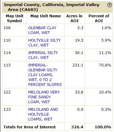
21 Map Unit Description: GLENBAR CLAY LOAM, WET Imperial County, California, Imperial Valley Area Imperial County, California, Imperial Valley Area 106 GLENBAR CLAY LOAM, WET Map Unit Setting Elevation: -230 to 200 feet Mean annual precipitation: 0 to 3 inches Mean annual air temperature: 72 to 75 degrees F Frost-free period: 300 to 350 days Map Unit Composition Glenbar, wet, and similar soils: 85 percent Minor components: 15 percent Description of Glenbar, Wet Setting Landform: Basin floors Landform position (three-dimensional): Dip Down-slope shape: Linear Across-slope shape: Linear Parent material: Alluvium derived from mixed sources Properties and qualities Slope: 0 to 1 percent Depth to restrictive feature: More than 80 inches Drainage class: Moderately well drained Capacity of the most limiting layer to transmit water (Ksat): Moderately high (0.20 to 0.57 in/hr) Depth to water table: More than 80 inches Frequency of flooding: None Frequency of ponding: None Calcium carbonate, maximum content: 5 percent Maximum salinity: Nonsaline to slightly saline (2.0 to 8.0 mmhos/cm) Sodium adsorption ratio, maximum: 5.0 Available water capacity: High (about 10.8 inches) Interpretive groups Land capability classification (irrigated): 2w Land capability (nonirrigated): 7w Typical profile 0 to 13 inches: Clay loam 13 to 60 inches: Clay loam Minor Components Holtville Percent of map unit: 5 percent Meloland Percent of map unit: 5 percent 11/18/2010 Page 1 of 2
22 Map Unit Description: GLENBAR CLAY LOAM, WET Imperial County, California, Imperial Valley Area Indio Percent of map unit: 5 percent Data Source Information Soil Survey Area: Imperial County, California, Imperial Valley Area Survey Area Data: Version 5, Jul 25, /18/2010 Page 2 of 2
23 Map Unit Description: HOLTVILLE SILTY CLAY, WET Imperial County, California, Imperial Valley Area Imperial County, California, Imperial Valley Area 110 HOLTVILLE SILTY CLAY, WET Map Unit Setting Elevation: -230 to 200 feet Mean annual precipitation: 0 to 3 inches Mean annual air temperature: 72 to 75 degrees F Frost-free period: 300 to 350 days Map Unit Composition Holtville, wet, and similar soils: 85 percent Minor components: 15 percent Description of Holtville, Wet Setting Landform: Basin floors Landform position (three-dimensional): Talf Down-slope shape: Linear Across-slope shape: Linear Parent material: Alluvium derived from mixed sources Properties and qualities Slope: 0 to 2 percent Depth to restrictive feature: More than 80 inches Drainage class: Moderately well drained Capacity of the most limiting layer to transmit water (Ksat): Very low to moderately low (0.00 to 0.06 in/hr) Depth to water table: More than 80 inches Frequency of flooding: None Frequency of ponding: None Calcium carbonate, maximum content: 5 percent Maximum salinity: Nonsaline to slightly saline (2.0 to 8.0 mmhos/cm) Sodium adsorption ratio, maximum: 10.0 Available water capacity: Moderate (about 7.6 inches) Interpretive groups Land capability classification (irrigated): 2w Land capability (nonirrigated): 7w Typical profile 0 to 17 inches: Silty clay 17 to 24 inches: Clay 24 to 35 inches: Silt loam 35 to 60 inches: Loamy very fine sand Minor Components Glenbar Percent of map unit: 5 percent Imperial Percent of map unit: 5 percent 11/18/2010 Page 1 of 2
24 Map Unit Description: HOLTVILLE SILTY CLAY, WET Imperial County, California, Imperial Valley Area Indio Percent of map unit: 3 percent Vint Percent of map unit: 2 percent Data Source Information Soil Survey Area: Imperial County, California, Imperial Valley Area Survey Area Data: Version 5, Jul 25, /18/2010 Page 2 of 2
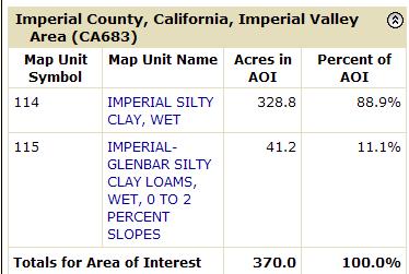
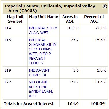
25 Map Unit Description: IMPERIAL SILTY CLAY, WET Imperial County, California, Imperial Valley Area Imperial County, California, Imperial Valley Area 114 IMPERIAL SILTY CLAY, WET Map Unit Setting Elevation: -230 to 200 feet Mean annual precipitation: 0 to 3 inches Mean annual air temperature: 72 to 75 degrees F Frost-free period: 300 to 350 days Map Unit Composition Imperial, wet, and similar soils: 85 percent Minor components: 15 percent Description of Imperial, Wet Setting Landform: Basin floors Landform position (three-dimensional): Talf Down-slope shape: Linear Across-slope shape: Linear Parent material: Clayey alluvium derived from mixed sources and/or clayey lacustrine deposits derived from mixed sources Properties and qualities Slope: 0 to 2 percent Depth to restrictive feature: More than 80 inches Drainage class: Moderately well drained Capacity of the most limiting layer to transmit water (Ksat): Moderately low to moderately high (0.06 to 0.20 in/hr) Depth to water table: More than 80 inches Frequency of flooding: None Frequency of ponding: None Calcium carbonate, maximum content: 5 percent Maximum salinity: Very slightly saline to slightly saline (4.0 to 8.0 mmhos/cm) Sodium adsorption ratio, maximum: 20.0 Available water capacity: Moderate (about 8.3 inches) Interpretive groups Land capability classification (irrigated): 3w Land capability (nonirrigated): 7w Typical profile 0 to 12 inches: Silty clay 12 to 60 inches: Silty clay loam Minor Components Glenbar Percent of map unit: 4 percent Meloland Percent of map unit: 4 percent 11/12/2010 Page 1 of 2
26 Map Unit Description: IMPERIAL SILTY CLAY, WET Imperial County, California, Imperial Valley Area Holtville Percent of map unit: 4 percent Niland Percent of map unit: 3 percent Data Source Information Soil Survey Area: Imperial County, California, Imperial Valley Area Survey Area Data: Version 5, Jul 25, /12/2010 Page 2 of 2
27 Map Unit Description: IMPERIAL-GLENBAR SILTY CLAY LOAMS, WET, 0 TO 2 PERCENT SLOPES Imperial County, California, Imperial Valley Area Imperial County, California, Imperial Valley Area 115 IMPERIAL-GLENBAR SILTY CLAY LOAMS, WET, 0 TO 2 PERCENT SLOPES Map Unit Setting Elevation: -230 to 200 feet Mean annual precipitation: 0 to 3 inches Mean annual air temperature: 72 to 75 degrees F Frost-free period: 300 to 350 days Map Unit Composition Glenbar, wet, and similar soils: 40 percent Imperial, wet, and similar soils: 40 percent Minor components: 20 percent Description of Imperial, Wet Setting Landform: Basin floors Landform position (three-dimensional): Talf Down-slope shape: Linear Across-slope shape: Linear Parent material: Clayey alluvium derived from mixed sources and/or clayey lacustrine deposits derived from mixed sources Properties and qualities Slope: 0 to 2 percent Depth to restrictive feature: More than 80 inches Drainage class: Moderately well drained Capacity of the most limiting layer to transmit water (Ksat): Moderately high (0.20 to 0.57 in/hr) Depth to water table: More than 80 inches Frequency of flooding: None Frequency of ponding: None Calcium carbonate, maximum content: 5 percent Maximum salinity: Very slightly saline to slightly saline (4.0 to 8.0 mmhos/cm) Sodium adsorption ratio, maximum: 20.0 Available water capacity: Moderate (about 8.6 inches) Interpretive groups Land capability classification (irrigated): 3w Land capability (nonirrigated): 7w Typical profile 0 to 12 inches: Silty clay loam 12 to 60 inches: Silty clay loam Description of Glenbar, Wet Setting Landform: Basin floors Landform position (three-dimensional): Talf 11/12/2010 Page 1 of 2
28 Map Unit Description: IMPERIAL-GLENBAR SILTY CLAY LOAMS, WET, 0 TO 2 PERCENT SLOPES Imperial County, California, Imperial Valley Area Down-slope shape: Linear Across-slope shape: Linear Parent material: Alluvium derived from mixed Properties and qualities Slope: 0 to 2 percent Depth to restrictive feature: More than 80 inches Drainage class: Moderately well drained Capacity of the most limiting layer to transmit water (Ksat): Moderately high (0.20 to 0.57 in/hr) Depth to water table: More than 80 inches Frequency of flooding: None Frequency of ponding: None Calcium carbonate, maximum content: 5 percent Maximum salinity: Nonsaline to slightly saline (2.0 to 8.0 mmhos/cm) Sodium adsorption ratio, maximum: 15.0 Available water capacity: High (about 10.8 inches) Interpretive groups Land capability classification (irrigated): 3w Land capability (nonirrigated): 7w Typical profile 0 to 13 inches: Silty clay loam 13 to 60 inches: Clay loam Minor Components Holtville Percent of map unit: 10 percent Meloland Percent of map unit: 10 percent Data Source Information Soil Survey Area: Imperial County, California, Imperial Valley Area Survey Area Data: Version 5, Jul 25, /12/2010 Page 2 of 2
29 Map Unit Description: IMPERIAL-GLENBAR SILTY CLAY LOAMS, 2 TO 5 PERCENT SLOPE S Imperial County, California, Imperial Valley Area Imperial County, California, Imperial Valley Area 116 IMPERIAL-GLENBAR SILTY CLAY LOAMS, 2 TO 5 PERCENT SLOPE S Map Unit Setting Elevation: -230 to 200 feet Mean annual precipitation: 0 to 3 inches Mean annual air temperature: 72 to 75 degrees F Frost-free period: 300 to 350 days Map Unit Composition Glenbar and similar soils: 40 percent Imperial and similar soils: 40 percent Minor components: 20 percent Description of Imperial Setting Landform: Basin floors Landform position (three-dimensional): Rise Down-slope shape: Linear Across-slope shape: Linear Parent material: Clayey alluvium derived from mixed sources and/or clayey lacustrine deposits derived from mixed sources Properties and qualities Slope: 2 to 5 percent Depth to restrictive feature: More than 80 inches Drainage class: Moderately well drained Capacity of the most limiting layer to transmit water (Ksat): Moderately high (0.20 to 0.57 in/hr) Depth to water table: More than 80 inches Frequency of flooding: None Frequency of ponding: None Calcium carbonate, maximum content: 5 percent Maximum salinity: Very slightly saline to slightly saline (4.0 to 8.0 mmhos/cm) Sodium adsorption ratio, maximum: 20.0 Available water capacity: Moderate (about 8.6 inches) Interpretive groups Land capability classification (irrigated): 3e Land capability (nonirrigated): 7e Typical profile 0 to 13 inches: Silty clay loam 13 to 60 inches: Silty clay loam Description of Glenbar Setting Landform: Basin floors Landform position (three-dimensional): Rise 11/18/2010 Page 1 of 2
30 Map Unit Description: IMPERIAL-GLENBAR SILTY CLAY LOAMS, 2 TO 5 PERCENT SLOPE S Imperial County, California, Imperial Valley Area Down-slope shape: Linear Across-slope shape: Linear Parent material: Alluvium derived from mixed Properties and qualities Slope: 2 to 5 percent Depth to restrictive feature: More than 80 inches Drainage class: Well drained Capacity of the most limiting layer to transmit water (Ksat): Moderately high (0.20 to 0.57 in/hr) Depth to water table: More than 80 inches Frequency of flooding: None Frequency of ponding: None Calcium carbonate, maximum content: 5 percent Maximum salinity: Nonsaline to very slightly saline (2.0 to 4.0 mmhos/ cm) Sodium adsorption ratio, maximum: 10.0 Available water capacity: High (about 10.8 inches) Interpretive groups Land capability classification (irrigated): 3e Land capability (nonirrigated): 7e Typical profile 0 to 13 inches: Silty clay loam 13 to 60 inches: Clay loam Minor Components Holtville Percent of map unit: 10 percent Meloland Percent of map unit: 10 percent Data Source Information Soil Survey Area: Imperial County, California, Imperial Valley Area Survey Area Data: Version 5, Jul 25, /18/2010 Page 2 of 2
31 Map Unit Description: INDIO-VINT COMPLEX Imperial County, California, Imperial Valley Area Imperial County, California, Imperial Valley Area 119 INDIO-VINT COMPLEX Map Unit Setting Elevation: -230 to 300 feet Mean annual precipitation: 0 to 3 inches Mean annual air temperature: 72 to 75 degrees F Frost-free period: 300 to 350 days Map Unit Composition Indio and similar soils: 35 percent Vint and similar soils: 30 percent Minor components: 35 percent Description of Indio Setting Landform: Basin floors Landform position (three-dimensional): Talf Down-slope shape: Linear Across-slope shape: Linear Parent material: Alluvium derived from mixed sources and/or eolian deposits derived from mixed sources Properties and qualities Slope: 0 to 2 percent Depth to restrictive feature: More than 80 inches Drainage class: Well drained Capacity of the most limiting layer to transmit water (Ksat): Moderately high to high (0.57 to 1.98 in/hr) Depth to water table: More than 80 inches Frequency of flooding: None Frequency of ponding: None Calcium carbonate, maximum content: 5 percent Maximum salinity: Nonsaline to very slightly saline (0.0 to 4.0 mmhos/ cm) Sodium adsorption ratio, maximum: 5.0 Available water capacity: Moderate (about 8.5 inches) Interpretive groups Land capability classification (irrigated): 2s Land capability (nonirrigated): 7e Typical profile 0 to 12 inches: Loam 12 to 72 inches: Stratified loamy very fine sand to silt loam Description of Vint Setting Landform: Basin floors Landform position (three-dimensional): Talf Down-slope shape: Linear 11/18/2010 Page 1 of 2
32 Map Unit Description: INDIO-VINT COMPLEX Imperial County, California, Imperial Valley Area Across-slope shape: Linear Parent material: Alluvium and/or eolian deposits derived from mixed Properties and qualities Slope: 0 to 2 percent Depth to restrictive feature: More than 80 inches Drainage class: Well drained Capacity of the most limiting layer to transmit water (Ksat): High to very high (5.95 to in/hr) Depth to water table: More than 80 inches Frequency of flooding: None Frequency of ponding: None Calcium carbonate, maximum content: 5 percent Maximum salinity: Nonsaline to very slightly saline (2.0 to 4.0 mmhos/ cm) Sodium adsorption ratio, maximum: 5.0 Available water capacity: Low (about 4.9 inches) Interpretive groups Land capability classification (irrigated): 2s Land capability (nonirrigated): 7e Typical profile 0 to 10 inches: Loamy fine sand 10 to 60 inches: Loamy sand Minor Components Meloland Percent of map unit: 12 percent Holtville Percent of map unit: 12 percent Rositas Percent of map unit: 11 percent Data Source Information Soil Survey Area: Imperial County, California, Imperial Valley Area Survey Area Data: Version 5, Jul 25, /18/2010 Page 2 of 2
33 Map Unit Description: MELOLAND VERY FINE SANDY LOAM, WET Imperial County, California, Imperial Valley Area Imperial County, California, Imperial Valley Area 122 MELOLAND VERY FINE SANDY LOAM, WET Map Unit Setting Elevation: -230 to 200 feet Mean annual precipitation: 0 to 3 inches Mean annual air temperature: 72 to 75 degrees F Frost-free period: 300 to 350 days Map Unit Composition Meloland, wet, and similar soils: 85 percent Minor components: 15 percent Description of Meloland, Wet Setting Landform: Basin floors Landform position (three-dimensional): Talf Down-slope shape: Linear Across-slope shape: Linear Parent material: Alluvium derived from mixed sources and/or eolian deposits derived from mixed sources Properties and qualities Slope: 0 to 2 percent Depth to restrictive feature: More than 80 inches Drainage class: Moderately well drained Capacity of the most limiting layer to transmit water (Ksat): Very low to moderately low (0.00 to 0.06 in/hr) Depth to water table: More than 80 inches Frequency of flooding: None Frequency of ponding: None Calcium carbonate, maximum content: 5 percent Maximum salinity: Slightly saline to moderately saline (8.0 to 16.0 mmhos/cm) Sodium adsorption ratio, maximum: 13.0 Available water capacity: Moderate (about 7.8 inches) Interpretive groups Land capability classification (irrigated): 3w Land capability (nonirrigated): 7w Typical profile 0 to 12 inches: Very fine sandy loam 12 to 26 inches: Stratified loamy fine sand to silt loam 26 to 71 inches: Clay Minor Components Imperial Percent of map unit: 3 percent 11/18/2010 Page 1 of 2
34 Map Unit Description: MELOLAND VERY FINE SANDY LOAM, WET Imperial County, California, Imperial Valley Area Indio Percent of map unit: 3 percent Holtville Percent of map unit: 3 percent Glenbar Percent of map unit: 3 percent Vint Percent of map unit: 3 percent Data Source Information Soil Survey Area: Imperial County, California, Imperial Valley Area Survey Area Data: Version 5, Jul 25, /18/2010 Page 2 of 2
35 Map Unit Description: MELOLAND AND HOLTVILLE LOAMS, WET Imperial County, California, Imperial Valley Area Imperial County, California, Imperial Valley Area 123 MELOLAND AND HOLTVILLE LOAMS, WET Map Unit Setting Elevation: -230 to 300 feet Mean annual precipitation: 0 to 3 inches Mean annual air temperature: 72 to 75 degrees F Frost-free period: 300 to 350 days Map Unit Composition Holtville, wet, and similar soils: 40 percent Meloland, wet, and similar soils: 40 percent Minor components: 20 percent Description of Meloland, Wet Setting Landform: Basin floors Landform position (three-dimensional): Talf Down-slope shape: Linear Across-slope shape: Linear Parent material: Alluvium derived from mixed sources and/or eolian deposits derived from mixed sources Properties and qualities Slope: 0 to 2 percent Depth to restrictive feature: More than 80 inches Drainage class: Moderately well drained Capacity of the most limiting layer to transmit water (Ksat): Very low to moderately low (0.00 to 0.06 in/hr) Depth to water table: More than 80 inches Frequency of flooding: None Frequency of ponding: None Calcium carbonate, maximum content: 5 percent Maximum salinity: Slightly saline to moderately saline (8.0 to 16.0 mmhos/cm) Sodium adsorption ratio, maximum: 13.0 Available water capacity: Moderate (about 7.4 inches) Interpretive groups Land capability classification (irrigated): 3w Land capability (nonirrigated): 7w Typical profile 0 to 12 inches: Loam 12 to 26 inches: Stratified loamy fine sand to silt loam 26 to 38 inches: Clay 38 to 60 inches: Stratified silt loam to loamy fine sand Description of Holtville, Wet Setting Landform: Basin floors 11/18/2010 Page 1 of 2
36 Map Unit Description: MELOLAND AND HOLTVILLE LOAMS, WET Imperial County, California, Imperial Valley Area Landform position (three-dimensional): Talf Down-slope shape: Linear Across-slope shape: Linear Parent material: Alluvium and/or lacustrine deposits derived from mixed Properties and qualities Slope: 0 to 2 percent Depth to restrictive feature: More than 80 inches Drainage class: Moderately well drained Capacity of the most limiting layer to transmit water (Ksat): Very low to moderately low (0.00 to 0.06 in/hr) Depth to water table: More than 80 inches Frequency of flooding: None Frequency of ponding: None Calcium carbonate, maximum content: 5 percent Maximum salinity: Nonsaline to slightly saline (2.0 to 8.0 mmhos/cm) Sodium adsorption ratio, maximum: 10.0 Available water capacity: Moderate (about 7.7 inches) Interpretive groups Land capability classification (irrigated): 3w Land capability (nonirrigated): 7w Typical profile 0 to 12 inches: Loam 12 to 24 inches: Clay 24 to 36 inches: Silt loam 36 to 60 inches: Loamy very fine sand Minor Components Glenbar Percent of map unit: 4 percent Imperial Percent of map unit: 4 percent Indio Percent of map unit: 4 percent Rositas Percent of map unit: 4 percent Vint Percent of map unit: 4 percent Data Source Information Soil Survey Area: Imperial County, California, Imperial Valley Area Survey Area Data: Version 5, Jul 25, /18/2010 Page 2 of 2
37 California Revised Storie Index Rating (CA) Imperial County, California, Imperial Valley Area California Revised Storie Index Rating (CA) The Storie Index is a soil rating based on soil properties that govern a soil's potential for cultivated agriculture in California. The Storie Index asseses the productivity of a soil from the following four characteristics: Factor A, degree of soil profile development; factor B, texture of the surface layer; factor C, slope; and factor X, manageable features, including drainage, microrelief, fertility, acidity, erosion, and salt content. A score ranging from 0 to 100 percent is determined for each factor, and the scores are mukltiplied together to derive an index rating. For simplification, Storie Index ratings have been combined into six grades classes as follows: Grade 1 (excellent), 100 to 80; grade 2 (good), 79 to 60; grade 3 (fair), 59 to 40; grade 4 (poor), 39 to 20; grade 5 (very poor), 19 to 10; and grade 6 (nonagricultural), less than 10. Report California Revised Storie Index Rating (CA) The Storie Index is a soil rating based on soil properties that govern a soil map unit component's potential for cultivated agriculture. [Absence of an entry indicates that a Storie Index rating is not applicable or was not estimated]. For simplification, Storie Index ratings have been combined into six grades as follows: Grade 1 (Excellent): Soils that rate between 80 and 100 and which are suitable for a wide range of crops. Grade 2 (Good) Soils that rate between 60 and 79 and which are suitable for a wide range of crops. Grade 3 (Fair): Soils that range between 40 and 59. Soils in this grade may give good results with certain specialized crops. Grade 4 (Poor): Soils that rate between 20 and 39 and which have a narrow range in their agricultural potential. Grade 5 (Very Poor): Soil that rate between 10 and 19 and are of very limited agricultural use except for pasture because of adverse soil conditions. Grade 6 (Nonagricultural): Soils that rate less than 10. [The numbers in the "Limiting feature value" column range from 0.01 to Soils with a smaller the value have a lower potential for cultivated agriculture. The table shows each of the sub-factors used to generate the Storie Index rating for each soil component]. California Revised Storie Index Rating (CA) Imperial County, California, Imperial Valley Area Map symbol and soil name Pct. of map unit Storie index rating California Revised Storie Index (CA) Storie index grade and limiting features Limiting feature value 106 GLENBAR CLAY LOAM, WET Glenbar, wet Grade Two - Good Rated Soil Order 1.00 Profile Group 1.00 Nearly level to gently sloping 0.98 USDA Texture 0.95 Wetness, flooding, ponding, drainage, erosion /18/2010 Page 1 of 4
38 California Revised Storie Index Rating (CA) Imperial County, California, Imperial Valley Area California Revised Storie Index Rating (CA) Imperial County, California, Imperial Valley Area Map symbol and soil name Pct. of map unit Storie index rating California Revised Storie Index (CA) Storie index grade and limiting features Limiting feature value 110 HOLTVILLE SILTY CLAY, WET Holtville, wet Grade Three - Fair Rated Soil Order 1.00 Profile Group 1.00 Nearly level to gently sloping Wetness, flooding, ponding, drainage, erosion Toxicity IMPERIAL SILTY CLAY, WET Imperial, wet Grade Three - Fair Rated Soil Order 1.00 Profile Group 1.00 Nearly level to gently sloping Wetness, flooding, ponding, drainage, erosion Toxicity IMPERIAL-GLENBAR SILTY CLAY LOAMS, WET, 0 TO 2 PERCENT SLOPES Glenbar, wet Grade Two - Good Rated Soil Order 1.00 Profile Group 1.00 Nearly level to gently sloping 0.98 USDA Texture 0.95 Wetness, flooding, ponding, drainage, erosion 0.90 Imperial, wet Grade Two - Good Rated Soil Order 1.00 Profile Group 1.00 Nearly level to gently sloping 0.98 USDA Texture 0.95 Wetness, flooding, ponding, drainage, erosion /18/2010 Page 2 of 4
39 California Revised Storie Index Rating (CA) Imperial County, California, Imperial Valley Area California Revised Storie Index Rating (CA) Imperial County, California, Imperial Valley Area Map symbol and soil name Pct. of map unit Storie index rating California Revised Storie Index (CA) Storie index grade and limiting features Limiting feature value 119 INDIO-VINT COMPLEX Indio Grade One - Excellent USDA Texture 1.00 Rated Soil Order 1.00 Profile Group 1.00 Wetness, flooding, ponding, drainage, erosion Nearly level to gently sloping Vint Grade One - Excellent Rated Soil Order 1.00 Profile Group 1.00 Wetness, flooding, ponding, drainage, erosion Nearly level to gently sloping Toxicity MELOLAND VERY FINE SANDY LOAM, WET Meloland, wet Grade Three - Fair USDA Texture 1.00 Rated Soil Order 1.00 Profile Group 1.00 Nearly level to gently sloping Wetness, flooding, ponding, drainage, erosion /18/2010 Page 3 of 4
40 California Revised Storie Index Rating (CA) Imperial County, California, Imperial Valley Area California Revised Storie Index Rating (CA) Imperial County, California, Imperial Valley Area Map symbol and soil name Pct. of map unit Storie index rating California Revised Storie Index (CA) Storie index grade and limiting features Limiting feature value 123 MELOLAND AND HOLTVILLE LOAMS, WET Holtville, wet Grade Two - Good USDA Texture 1.00 Rated Soil Order 1.00 Profile Group 1.00 Nearly level to gently sloping Wetness, flooding, ponding, drainage, erosion Meloland, wet Grade Three - Fair USDA Texture 1.00 Rated Soil Order 1.00 Profile Group 1.00 Nearly level to gently sloping Wetness, flooding, ponding, drainage, erosion Data Source Information Soil Survey Area: Imperial County, California, Imperial Valley Area Survey Area Data: Version 5, Jul 25, /18/2010 Page 4 of 4
41 California Revised Storie Index Rating (CA) Imperial County, California, Imperial Valley Area California Revised Storie Index Rating (CA) The Storie Index is a soil rating based on soil properties that govern a soil's potential for cultivated agriculture in California. The Storie Index asseses the productivity of a soil from the following four characteristics: Factor A, degree of soil profile development; factor B, texture of the surface layer; factor C, slope; and factor X, manageable features, including drainage, microrelief, fertility, acidity, erosion, and salt content. A score ranging from 0 to 100 percent is determined for each factor, and the scores are mukltiplied together to derive an index rating. For simplification, Storie Index ratings have been combined into six grades classes as follows: Grade 1 (excellent), 100 to 80; grade 2 (good), 79 to 60; grade 3 (fair), 59 to 40; grade 4 (poor), 39 to 20; grade 5 (very poor), 19 to 10; and grade 6 (nonagricultural), less than 10. Report California Revised Storie Index Rating (CA) The Storie Index is a soil rating based on soil properties that govern a soil map unit component's potential for cultivated agriculture. [Absence of an entry indicates that a Storie Index rating is not applicable or was not estimated]. For simplification, Storie Index ratings have been combined into six grades as follows: Grade 1 (Excellent): Soils that rate between 80 and 100 and which are suitable for a wide range of crops. Grade 2 (Good) Soils that rate between 60 and 79 and which are suitable for a wide range of crops. Grade 3 (Fair): Soils that range between 40 and 59. Soils in this grade may give good results with certain specialized crops. Grade 4 (Poor): Soils that rate between 20 and 39 and which have a narrow range in their agricultural potential. Grade 5 (Very Poor): Soil that rate between 10 and 19 and are of very limited agricultural use except for pasture because of adverse soil conditions. Grade 6 (Nonagricultural): Soils that rate less than 10. [The numbers in the "Limiting feature value" column range from 0.01 to Soils with a smaller the value have a lower potential for cultivated agriculture. The table shows each of the sub-factors used to generate the Storie Index rating for each soil component]. California Revised Storie Index Rating (CA) Imperial County, California, Imperial Valley Area Map symbol and soil name Pct. of map unit Storie index rating California Revised Storie Index (CA) Storie index grade and limiting features Limiting feature value 114 IMPERIAL SILTY CLAY, WET Imperial, wet Grade Three - Fair Rated Soil Order 1.00 Profile Group 1.00 Nearly level to gently sloping Wetness, flooding, ponding, drainage, erosion Toxicity /18/2010 Page 1 of 3
42 California Revised Storie Index Rating (CA) Imperial County, California, Imperial Valley Area California Revised Storie Index Rating (CA) Imperial County, California, Imperial Valley Area Map symbol and soil name Pct. of map unit Storie index rating California Revised Storie Index (CA) Storie index grade and limiting features Limiting feature value 115 IMPERIAL-GLENBAR SILTY CLAY LOAMS, WET, 0 TO 2 PERCENT SLOPES Glenbar, wet Grade Two - Good Rated Soil Order 1.00 Profile Group 1.00 Nearly level to gently sloping 0.98 USDA Texture 0.95 Wetness, flooding, ponding, drainage, erosion 0.90 Imperial, wet Grade Two - Good Rated Soil Order 1.00 Profile Group 1.00 Nearly level to gently sloping 0.98 USDA Texture 0.95 Wetness, flooding, ponding, drainage, erosion IMPERIAL-GLENBAR SILTY CLAY LOAMS, 2 TO 5 PERCENT SLOPE S Glenbar Grade One - Excellent Rated Soil Order 1.00 Profile Group 1.00 Wetness, flooding, ponding, drainage, erosion 1.00 USDA Texture 0.95 Toxicity 0.94 Imperial Grade Two - Good Rated Soil Order 1.00 Profile Group 1.00 USDA Texture 0.95 Undulating to moderately sloping Wetness, flooding, ponding, drainage, erosion /18/2010 Page 2 of 3
43 California Revised Storie Index Rating (CA) Imperial County, California, Imperial Valley Area Data Source Information Soil Survey Area: Imperial County, California, Imperial Valley Area Survey Area Data: Version 5, Jul 25, /18/2010 Page 3 of 3
APPENDIX E. LESA Models
 APPENDIX E LESA Models LESA ASSESSMENT CALEXICO SOLAR FARM I PHASE A PROJECT AREA CALEXICO SOLAR FARM I PHASE A PROJECT (SW/4 Section 13, S/2 Section 14, S/2 NE/4 Section 15, NW/4 Section 15, T17S, R13E,
Appendix M Land Evaluation and Site Assessment (Calipatria I, Midway I and Midway II)
") Appendix M Land Evaluation and Site Assessment (Calipatria I, Midway I and Midway II) LESA ASSESSMENT CALIPATRIA SOLAR FARM I PROJECT AREA CALIPATRIA SOLAR FARM I PROJECT (Section 10 (portion), T12S, R14E,
Appendix M Land Evaluation and Site Assessment (Calipatria I, Midway I and Midway II) LESA ASSESSMENT CALIPATRIA SOLAR FARM I PROJECT AREA CALIPATRIA SOLAR FARM I PROJECT (Section 10 (portion), T12S, R14E,
LESA ASSESSMENT LAUREL SOLAR PROJECT (T16S, R12E, S26, SBB&M)
") LESA ASSESSMENT LAUREL SOLAR PROJECT (T16S, R12E, S26, SBB&M) IMPERIAL COUNTY, CALIFORNIA May 2017 EMA Report No. 2377-01 Prepared for: 90FI 8me LLC 111 Woodmere Road, Suite 250 Folsom, CA 95630 ENVIRONMENTAL
LESA ASSESSMENT LAUREL SOLAR PROJECT (T16S, R12E, S26, SBB&M) IMPERIAL COUNTY, CALIFORNIA May 2017 EMA Report No. 2377-01 Prepared for: 90FI 8me LLC 111 Woodmere Road, Suite 250 Folsom, CA 95630 ENVIRONMENTAL
APPENDIX I LESA MODELS
 APPENDIX I LESA MODELS LESA ASSESSMENT SEVILLE 4 SOLAR PROJECT HORIZONTAL SINGLE-AXIS TRACKING ARRAY (T16S, R12E, S25, SBB&M) IMPERIAL COUNTY, CALIFORNIA July 2017 EMA Report No. 2375-01 Prepared for:
LESA ASSESSMENT BIG ROCK 1 SOLAR PROJECT (T16S, R12E, S27, S34 & S35, SBB&M)
") LESA ASSESSMENT BIG ROCK 1 SOLAR PROJECT (T16S, R12E, S27, S34 & S35, SBB&M) IMPERIAL COUNTY, CALIFORNIA September 2017 EMA Report No. 2385-01 Prepared for: 92JT 8me LLC 111 Woodmere Road, Suite 250 Folsom,
LESA ASSESSMENT BIG ROCK 1 SOLAR PROJECT (T16S, R12E, S27, S34 & S35, SBB&M) IMPERIAL COUNTY, CALIFORNIA September 2017 EMA Report No. 2385-01 Prepared for: 92JT 8me LLC 111 Woodmere Road, Suite 250 Folsom,
 SEPV Dixieland West Project Location Proposed KOPs SEPV Dixieland West #1. Intersection of Evan Hewes and Carriso Avenue. One looking north, one looking west. HDR approved this view for KOP#2 - Looking
Land Evaluation and Site Assessment Model
 Land Evaluation and Site Assessment Model Citizens Imperial Solar, LLC Project Imperial County, CA June 6, 2018 This page is intentionally blank. Land Evaluation and Site Assessment Model Citizens Imperial
Appendix 2. Agricultural Resources a. LESA Worksheets b. NRCS Soil Survey
 Appendix 2 Agricultural Resources a. LESA Worksheets b. NRCS Soil Survey Appendix 2a LESA Worksheets Appendix A. California Agricultural LESA Worksheet The California Agricultural LESA Model is composed
Santa Clara Area, California, Western Part
 Santa Clara Area, California, Western Part 101 Urban land, 0 to 2 percent slopes, basins Map Unit Setting Landscape: Alluvial plains, basins Elevation: 0 to 80 feet Mean annual precipitation: 14 to 30
Appendix A. California Agricultural LESA Worksheets
 City of Sanger - Indianolaa Subdivision Project Initial Study/Mitigated Negative Declaration Appendix A: LESA Model Worksheets FirstCarbon Solutions H:\Client (PN-JN)\2775\27750059\ISMND\27750059 Indianola
Custom Soil Resource Report for Douglas County, Washington
 United States Department of Agriculture Natural Resources Conservation Service A product of the National Cooperative Soil Survey, a joint effort of the United States Department of Agriculture and other
Custom Soil Resource Report for Douglas County, Washington
 United States Department of Agriculture Natural Resources Conservation Service A product of the National Cooperative Soil Survey, a joint effort of the United States Department of Agriculture and other
Custom Soil Resource Report for Dallam County, Texas
 United States Department of Agriculture Natural Resources Conservation Service A product of the National Cooperative Soil Survey, a joint effort of the United States Department of Agriculture and other
Custom Soil Resource Report for St. Lucie County, Florida Gopherbroke Farms
 United States Department of Agriculture Natural Resources Conservation Service A product of the National Cooperative Soil Survey, a joint effort of the United States Department of Agriculture and other
APPENDIX J CRYSTAL GEYSER ONSITE IRRIGATION SYSTEM TECHNICAL MEMORANDUM
 APPENDIX J CRYSTAL GEYSER ONSITE IRRIGATION SYSTEM TECHNICAL MEMORANDUM DRAFT TECHNICAL MEMORANDUM Crystal Geyser Onsite Irrigation System PREPARED FOR: PREPARED BY: REVIEWED BY: Richard Weklych/CGWC Barbara
Custom Soil Resource Report for St. Lucie County, Florida
 United States Department of Agriculture Natural Resources Conservation Service A product of the National Cooperative Soil Survey, a joint effort of the United States Department of Agriculture and other
4.11 AGRICULTURAL RESOURCES INTRODUCTION ENVIRONMENTAL SETTING. Regional. Project Site Setting
 4.11 AGRICULTURAL RESOURCES 4.11.1 INTRODUCTION This section addresses the potential for the Proposed Project to impact the agricultural resources in and around the Proposed Project location. Following
117 Meyers Street Suite 120 Chico CA
 117 Meyers Street Suite 120 Chico CA 95928 530-332-9909 Technical Memorandum: California Department of Conservation Land Evaluation and Site Assessment Model for the Vineyard Crossing Subdivision, Mendocino,
4.2 Agriculture and Forestry Resources
 The purpose of this Section is to identify existing agriculture and forest resources within the Project area, analyze potential agriculture and forest resources associated with the development of the proposed
Custom Soil Resource Report for Pamlico County, North Carolina
 United States Department of Agriculture Natural Resources Conservation Service A product of the National Cooperative Soil Survey, a joint effort of the United States Department of Agriculture and other
Custom Soil Resource Report for Wright County, Minnesota
 United States Department of Agriculture Natural Resources Conservation Service A product of the National Cooperative Soil Survey, a joint effort of the United States Department of Agriculture and other
Custom Soil Resource Report for Okeechobee County, Florida
 United States Department of Agriculture Natural Resources Conservation Service A product of the National Cooperative Soil Survey, a joint effort of the United States Department of Agriculture and other
Custom Soil Resource Report for Okeechobee County, Florida
 United States Department of Agriculture Natural Resources Conservation Service A product of the National Cooperative Soil Survey, a joint effort of the United States Department of Agriculture and other
Custom Soil Resource Report for Logan County, Oklahoma
 United States Department of Agriculture Natural Resources Conservation Service A product of the National Cooperative Soil Survey, a joint effort of the United States Department of Agriculture and other
Loam Ridge Almond Orchard
 AG-LAND Investment Brokers 645 Antelope Blvd., Suite 17 PO Box 896 Red Bluff, CA 96080 530-529-4400 Fax 530-527-5042 Loam Ridge Almond Orchard Contact: AG-LAND Investment Brokers Prepared by FSA Date:
Mule Ranch - Dorris, CA 1,234 +/- acres, Siskiyou County
 AG-LAND Investment Brokers 275 Sale Lane Red Bluff, CA 96080 530-529-4400 Fax 530-527-5042 Mule Ranch - Dorris, CA 1,234 +/- acres, Siskiyou County AG-LAND INVESTMENT BROKERS 275 Sale Lane / P. O. Box
Appendix D. Land Evaluation Site Assessment System
 Appendix D Land Evaluation Site Assessment System Town of Dewey Comprehensive Plan 2009 PORTAGE COUNTY S LAND EVALUATION SITE ASSESSMENT SYSTEM A tool to help local communities understand the agricultural
Custom Soil Resource Report for Isle of Wight County, Virginia, Southampton County, Virginia, and Surry County, Virginia
 United States Department of Agriculture Natural Resources Conservation Service A product of the National Cooperative Soil Survey, a joint effort of the United States Department of Agriculture and other
TIERRA SOUTH FLORIDA, INC. Geotechnical Engineering / Material Testing / Inspection Services
 TIERRA SOUTH FLORIDA, INC. Geotechnical Engineering / Material Testing / Inspection Services March 11, 2016 Kimley-Horn 1920 Wekiva Way Suite 200 West Palm Beach, Fl. 33411 Attn: Matthew B. Fursetzer,
FIELD PHOSPHORUS RISK ASSESSMENT
 NEBRASKA DEPARTMENT OF ENVIRONMENTAL QUALITY AGRICULTURE SECTION * 1200 N STREET, SUITE 400 * LINCOLN, NE 68509-8922 TEL: (402)471-4239 *FAX: (402) 471-2909 * WEB SITE: www.ndeq.state.ne.us APPENDIX F
Gonsalves Ranch, 756 +/- Total Acres Red Bluff, California
 AG-LAND INVESTMENT BROKERS 275 Sale Lane, Suite 2 / P. O. Box 896 Red Bluff, CA 96080 530.529.4400 office / 530.527.5042 fax Gonsalves Ranch, 756 +/- Total Acres Red Bluff, California Listing Price: $675,000.
NRCS Soils Information and Maps. Appendix F
 NRCS Soils Information and Maps Appendix F United States Department of Agriculture Natural Resources Conservation Service A product of the National Cooperative Soil Survey, a joint effort of the United
Custom Soil Resource Report for Columbus County, North Carolina
 United States Department of Agriculture Natural Resources Conservation Service A product of the National Cooperative Soil Survey, a joint effort of the United States Department of Agriculture and other
Custom Soil Resource Report for Montgomery County, Texas, Polk and San Jacinto Counties, Texas, and Walker County, Texas
 United States Department of Agriculture Natural Resources Conservation Service A product of the National Cooperative Soil Survey, a joint effort of the United States Department of Agriculture and other
Custom Soil Resource Report for Colquitt and Cook Counties, Georgia
 United States Department of Agriculture Natural Resources Conservation Service A product of the National Cooperative Soil Survey, a joint effort of the United States Department of Agriculture and other
AG-LAND Investment Brokers 275 Sale Lane Red Bluff, CA Fax Corning Eucalyptus Farm
 AG-LAND Investment Brokers 275 Sale Lane Red Bluff, CA 96080 530-529-4400 Fax 530-527-5042 Corning Eucalyptus Farm Tehama County,, California 1 of 6 deep irrigation wells Drip tubing rolled at the edge
Dye Creek Orchards Los Molinos, California
 AG-LAND INVESTMENT BROKERS 275Sale Lane / P. O. Box 896 Red Bluff, CA 96080 530.529.4400 office / 530.527.5042 fax Dye Creek Orchards Los Molinos, California Listing Price: $1,950,000. Seller financing
Soil Map Lewis County, Kentucky (Denham Farm, Sand Hill/Trinity, Lewis Co., KY) Web Soil Survey National Cooperative Soil Survey
 Web Soil Survey National Cooperative Soil Survey") 83 37' 43'' W (Denham Farm, Sand Hill/Trinity, Lewis Co., KY) 83 36' 18'' W 38 40' 37'' N 271500 271700 271900 272100 272300 272500 272700 272900 273100 273300 38 40' 37'' N 38 39' 54'' N 4282900 4283100
83 37' 43'' W (Denham Farm, Sand Hill/Trinity, Lewis Co., KY) 83 36' 18'' W 38 40' 37'' N 271500 271700 271900 272100 272300 272500 272700 272900 273100 273300 38 40' 37'' N 38 39' 54'' N 4282900 4283100
Soil Resource Report within Project Limits
 Preliminary Geotechnical Report El Camino Real Bus Rapid Transit Project Santa Clara County, California 04-SCL-82 Appendix A.3 Soil Resource Report within Project Limits November 2013 A-4 United States
The Big Picture SOILS, WETLANDS AND DEVELOPMENT SOILS OVERVIEW BRUCE BARBER. PWS, Soil Scientist Certified Ecologist CORNERSTONE ASSOCIATES
 SOILS, WETLANDS AND DEVELOPMENT BRUCE BARBER PWS, Soil Scientist Certified Ecologist CORNERSTONE ASSOCIATES 1770 CENTRAL STREET YORKTOWN HEIGHTS NY 10598 PHONE: (914) 962-7733 FAX: (914) 962-0330 EMAIL:
FOR SALE. FOR SALE /- Acres of Prime Almonds in LTRID and Saucelito Irrigation District. Morgan Houchin Tech Ag Financial Group, Inc.
 FOR SALE FOR SALE - 235.72 +/- Acres of Prime Almonds Morgan Houchin P.O. Box 98 Buttonwillow, CA 93206 Neither the Seller, nor makes any representations or warranties, either expressed or implied as to
Custom Soil Resource Report for Kent County, Michigan
 United States Department of Agriculture Natural Resources Conservation Service A product of the National Cooperative Soil Survey, a joint effort of the United States Department of Agriculture and other
Dairyville Irrigated Pasture & Home. Los Molinos, CA
 Dairyville Irrigated Pasture & Home Los Molinos, CA AG-LAND INVESTMENT BROKERS 275 Sale Lane, Suite 2 / P. O. Box 896 Red Bluff, CA 96080 530.529.4400 office / 530.527.5042 fax 68 th Avenue Irrigated Pasture
Custom Soil Resource Report for Polk County, Wisconsin
 United States Department of Agriculture Natural Resources Conservation Service A product of the National Cooperative Soil Survey, a joint effort of the United States Department of Agriculture and other
4.2 Agricultural Resources
 4.2 AGRICULTURAL RESOURCES This section provides an overview of existing agricultural resources within the project study areas and identifies applicable federal, state, and local policies related to the
Bicycle and pedestrian circulation is scored as follows:
 4. Bicycle and Pedestrian Circulation The mode split for walking and bicycling in the unincorporated areas of County are each less than one percent, which is less than half of the walking and biking mode
Pinheiro Ranch 55+/- Acres Orchard Development Ground Orland, CA. Presented By:
 Pinheiro Ranch 55+/- Acres Orchard Development Ground Orland, CA Presented By: Pinheiro Ranch 55+/- Acres Orchard Development Ground Orland, CA Location: This property is located on the SE corner of Road
Appendix - D. LESA Model Worksheets & Summary Tables. East Cherry Avenue Specific Plan Final EIR
 Appendix - D LESA Model Worksheets & Summary Tables East Cherry Avenue Specific Plan Final EIR This Page Intentionally Left Blank. Table D-1. LESA Analysis Summary for Site Land Evaluation (LE) Factor
IV.B AGRICULTURAL RESOURCES
 1. Environmental Setting IV.B AGRICULTURAL RESOURCES a. Study Area for Direct Impacts. The study area for determining agricultural resource impacts of the proposed Specific Plan is the proposed project
Appendix 10-A. Optional Recharge Volume Approach
 Appendix 10-A Optional Recharge Volume Approach Table of Contents APPENDIX SECTION HEADINGS 10-A.0 INTRODUCTION 10-A-2 10-A.1 Horsely Method for Determining Recharge Volumes 10-A-2 10-A.1.1 Basis for Determining
11. Prioritizing Farmlands for Future Protection
 11. Prioritizing Farmlands for Future Protection Identification of Important Farmlands in Putnam County I n order to implement this Plan successfully, Putnam County decision-makers will have to take advantage
4.6 AGRICULTURAL RESOURCES
 4.6 AGRICULTURAL RESOURCES Project implementation would result in the conversion of 60 acres of prime agricultural land to general retail, office/business park, and infrastructure uses. Impacts related
Water Resources Management Plan
 B u r n s v i l l e M i n n e s o t a Water Resources Management Plan - Volume Control / Infiltration Worksheet This Appendix contains a worksheet and related information that can be used for evaluating
PHYSICAL SOIL PROPERTIES
 PHYSICAL SOIL PROPERTIES Physical Soil Properties Santa Cruz County, California Scotts Valley Target Physical Soil Properties This table shows estimates of some physical characteristics and features that
Waller Ranch SANTA MARIA VALLEY, CALIFORNIA. West Side Santa Maria Berry Ground. 39± Useable Acres ($64,000± per acre) Available for $2,503,000
 Available for $2,503,000") Waller Ranch SANTA MARIA VALLEY, CALIFORNIA West Side Santa Maria Berry Ground 39± Useable Acres ($64,000± per acre) Available for $2,503,000 Presented by: Rincon corporation WALLER Ranch, Santa Maria
Waller Ranch SANTA MARIA VALLEY, CALIFORNIA West Side Santa Maria Berry Ground 39± Useable Acres ($64,000± per acre) Available for $2,503,000 Presented by: Rincon corporation WALLER Ranch, Santa Maria
( ) or 811 or mo1call.com
 or 811 or mo1call.com") Missouri One Call 1-800-DIG RITE (800-344-7483) or 811 or mo1call.com Missouri One Call 1-800-DIG RITE (800-344-7483) or 811 or mo1call.com Missouri One Call 1-800-DIG RITE (800-344-7483) or 811 or mo1call.com
Missouri One Call 1-800-DIG RITE (800-344-7483) or 811 or mo1call.com Missouri One Call 1-800-DIG RITE (800-344-7483) or 811 or mo1call.com Missouri One Call 1-800-DIG RITE (800-344-7483) or 811 or mo1call.com
Custom Soil Resource Report for Polk County, Wisconsin
 United States Department of Agriculture Natural Resources Conservation Service A product of the National Cooperative Soil Survey, a joint effort of the United States Department of Agriculture and other
3.2 AGRICULTURAL RESOURCES
 3.2 AGRICULTURAL RESOURCES The following section evaluates the potential impacts of the East Cherry Avenue Specific Plan (Project) on site-specific and regional agricultural resources, including prime
AG-LAND Investment Brokers 275 Sale Lane Red Bluff, CA Fax Paradox Seed Mother Orchard Red Bluff, CA
 AG-LAND Investment Brokers 275 Sale Lane Red Bluff, CA 96080 530-529-4400 Fax 530-527-5042 Paradox Seed Mother Orchard Red Bluff, CA AG-LAND INVESTMENT BROKERS 275 Sale Lane / P. O. Box 896 Red Bluff,
CHAPTER 7 PHYSICAL INVENTORY OF THE CITY
 CHAPTER 7 PHYSICAL INVENTORY OF THE CITY Chapter 7: Physical Inventory of the City 39 This page intentionally left blank. Chapter 7: Physical Inventory of the City 40 SECTION 1 PHYSICAL SETTING While communities
RI Site Specific Soil Mapping Standards and Procedures
 RI Site Specific Soil Mapping Standards and Procedures Understanding Hydrologic Soil Groups and Site Specific Mapping URI Coastal Institute, Kingston June 28 th 2012 Jillian Phillips URI Cooperative Extension
LAKE COUNTY HYDROLOGY DESIGN STANDARDS
 LAKE COUNTY HYDROLOGY DESIGN STANDARDS Lake County Department of Public Works Water Resources Division 255 N. Forbes Street Lakeport, CA 95453 (707)263-2341 Adopted June 22, 1999 These Standards provide
Appendix G Soils Characterization Report
 Appendix G Soils Characterization Report Draft Environmental Impact Report Beacon Photovoltaic Project July 2012 AECOM (805)388-3775 tel 1220 Avenida Acaso (805)388-3577 fax Camarillo, CA 93012 Memorandum
Nonmetallic Mining Reclamation & Operation Plan. Amendment No. 1 (Includes modifications for Wash Plant construction) DRAFT
 DRAFT") Nonmetallic Mining Reclamation & Operation Plan Amendment No. 1 (Includes modifications for Wash Plant construction) Mondovi Mine Town of Mondovi, Wisconsin Prepared for: Buffalo White Sand, LLC PO Box
Nonmetallic Mining Reclamation & Operation Plan Amendment No. 1 (Includes modifications for Wash Plant construction) Mondovi Mine Town of Mondovi, Wisconsin Prepared for: Buffalo White Sand, LLC PO Box
Planting # Planting History Senger planting Prepared by Kim Elsenbroek Maps by: Jocelyn Frazelle
 Planting # 117 2015 Planting History Senger planting Prepared by Kim Elsenbroek 11.13.2015 Maps by: Jocelyn Frazelle 30 Acres Total all in burned cornfield Mesic: 40 lbs/acre over 30 acres, total 1200
Koon Road Lugoff, South Carolina
 For Sale ±105 AC Pasture Land w/ Pond Koon Road Lugoff, South Carolina Tombo Milliken +1 803 206 8384 tombo.milliken@naiavant.com Tom Milliken +1 803 331 6999 tmilliken@naiavant.com THE INFORMATION CONTAINED
MOLOAʻA VALLEY FARMS SUBDIVISION
 MOLOAʻA VALLEY FARMS SUBDIVISION TAX MAP KEY (4) 4-9-011-013 Agricultural Master Plan - 1 - Introduction:...3 Parcel-wide Agricultural Considerations...3 Agricultural Use Details by Unit:...6 Unit 1:...6
±180 AC. Bull Swamp Road North, South Carolina. For Sale. Tombo Milliken
 PRICE REDUCED For Sale ±180 AC Bull Swamp Road North, South Carolina CONTACT BROKERS FOR MORE INFORMATION: Tombo Milliken +1 803 744 9852 tombo.milliken@naiavant.com Tom Milliken +1 803 744 9837 tmilliken@naiavant.com
3.2 AGRICULTURAL RESOURCES
 3.2 AGRICULTURAL RESOURCES 3.2.1 INTRODUCTION This section analyzes the potential direct, and indirect, impacts to agricultural resources within the project site and surrounding vicinity, as a result of
Herger Ranch /- Acres Madison, CA. Presented By:
 Herger Ranch 326.33+/- Acres Madison, CA Presented By: Herger Ranch 326.33+/- Acres Madison, CA Location: This ranch is located on the NW corner of Highway 16 and Road 89 in Madison, CA. The property stretches
Chapter 2: Conditions in the Spring Lake Watershed related to Stormwater Pollution
 Chapter 2: Conditions in the Spring Lake Watershed related to Stormwater Pollution To identify the primary causes and consequences of stormwater discharges to Spring Lake and its adjoining waterbodies,
McColl Fence Addition GEOTECHNICAL ASSESSMENT
 McColl Fence Addition GEOTECHNICAL ASSESSMENT Prepared For: Stuart McColl 1038 Hooker Road Sequim, WA 98382 SEPTEMBER 2012 Prepared By: Trent T. Adams, EIT Justin C. Wilson, PE NTI ENGINEERING & LAND SURVEYING
The C horizon, where encountered, is shale or marl or stratified layers of shale, marl and clay.
 is commonly silty clay or clay and less commonly silty clay loam or clay loam. Reaction ranges from moderately acid to slightly alkaline and is typically noncalcareous. The Ck or C horizon has colors in
SAMPLE DRAINAGE STATEMENT
 Firm Name & Logo Hidalgo County Drainage District No. 1 Drainage Statement Subdivision Name Hidalgo County, Texas Prepared By: Firm's Name Address City, State, Zip Telephone Fax Email Date SAMPLE DRAINAGE
2 Okanogan County Regional Setting
 1 1 1 1 1 1 1 1 0 1 0 1 Okanogan County Regional Setting.1 Okanogan County Profile Okanogan County is in North Central Washington State. The county borders Canada in the North and the southern and eastern
Standards for Soil Erosion and Sediment Control in New Jersey May 2012 STANDARD FOR GRASSED WATERWAYS. Definition. Purpose
 STANDARD FOR GRASSED WATERWAYS Definition A natural or constructed watercourse shaped or graded in earth materials and stabilized with suitable vegetation for the safe conveyance of runoff water. Purpose
Measured Seepage of the Main Canal Brownsville Irrigation District
 COLLEGE OF AGRICULTURE AND LIFE SCIENCES TR-372 2011 Measured Seepage of the Main Canal Brownsville Irrigation District By: Eric Leigh, Extension Associate and Guy Fipps, P.E., Extension Agricultural Engineer
At its November 8, 2018 meeting, the Planning Commission recommended approval of the voluntary agricultural and forestal district.
 SOUTHAMPTON COUNTY BOARD OF SUPERVISORS Regular Session December 17, 2018 11G. PUBLIC HEARING AG & FORESTAL DISTRICT CARTER A. SMITH. ET ALS OPENING STATEMENT This public hearing is held pursuant to Section
Good Irrigation Water Management Practices. December 7, 2016
 Good Irrigation Water Management Practices December 7, 2016 Good Irrigation Water Management Practices Spencer Cooper, Almond Board of California (Moderator) Larry Schwankl, UCCE Irrigation Specialist
FOR SALE. 1,237.33± Acres, Wasco Kern County, California. CA BRE # Exclusively Presented By: Pearson Realty
 FOR SALE Wasco Almonds & Farmland Opportunity 1,237.33± Acres, Wasco Kern County, California Access to district & well water Quality soils & well water to work with 747.13± acres of almonds, 595.52± acres
Web Soil Survey National Cooperative Soil Survey
 99 52' 37'' W Yields of Irrigated Crops (Component): Cotton lint (Lbs) Haskell County, Texas 99 51' 40'' W 33 21' 4'' N 418500 418600 418700 418800 418900 419000 419100 419200 419300 419400 419500 419600
At its December 14, 2017 meeting, the Planning Commission recommended approval of the voluntary agricultural and forestal district.
 SOUTHAMPTON COUNTY BOARD OF SUPERVISORS Regular Session i January 22, 2018 11B. PUBLIC HEARING AG & FORESTAL DISTRICT DARDEN, FALLS, BROWN, WIDMEYER AND BELTRAMI OPENING STATEMENT This public hearing is
Seepage and Conveyance Technical Feedback Group Meeting. March 2, Preliminary draft subject to change
 Seepage and Conveyance Technical Feedback Group Meeting March 2, 2017 Patti Ransdell INTRODUCTION 2 Agenda Introductions, Meeting Agenda SJRRP Updates January 23 Meeting Recap Capillary Fringe Buffer,
Central California Pistachios & Farmland Kings County, California
 Kings County, California 5,014.93± Assessed Acres District water, well water and ditch stock Young pistachios Additional land to plant permanent crops and/or to mitigate SGMA Tax benefits Good locations
Seepage Test Loss Results The Main Canal Valley Municipal Utility District No. 2
 TR-326 2008 Seepage Test Loss Results The Main Canal Valley Municipal Utility District No. 2 Eric Leigh Texas AgriLife Extension Associate, Biological and Agricultural Engineering, College Station Guy
FOR SALE. Arvin-Rancho Rd. Farmland Opportunity ± acres, Kern County, California. CA BRE #
 FOR SALE Arvin-Rancho Rd. Farmland Opportunity David Rd Edison Rd Rancho Rd Site 1 Site 2 Offsite well 371.37± acres, Kern County, California District and Well Water Strong Soils Located in White Wolf
PRELIMINARY DRAINAGE REPORT NEWCASTLE FIRE STATION OLD STATE HIGHWAY
 PRELIMINARY DRAINAGE REPORT FOR THE NEWCASTLE FIRE STATION OLD STATE HIGHWAY PREPARED FOR THE NEWCASTLE FIRE PROTECTION DISTRICT JULY 2014 BY ROSEVILLE DESIGN GROUP, INC. ROSEVILLE DESIGN GROUP, Inc Established
Initial Run-on and Run-off Control System Plan
 Initial Run-on and Run-off Control System Plan For Compliance with the Coal Combustion Residuals Rule (40 CFR 257.81) Valmont Station - Ash Disposal Facility Public Service Company of Colorado Denver,
PRELIMINARY DRAINAGE STUDY
 PRELIMINARY DRAINAGE STUDY FOR BIG ROCK CLUSTER SOLAR FARMS PREPARED FOR: Daniel Kolta 90FI 8me LLC & 92JT 8me LLC 211 Sutter Street, Fl. 6 San Francisco, CA. 94108 Prepared 5 15 17 Revised 5 26 17 Revised
Sargent, ND FARM LAND FOR SALE
 Sargent, ND FARM LAND FOR SALE 274.0 Acres Steve Johnson 146th Ave SE 147th Ave SE 148th Ave SE 148th Ave 147th Ave 146th Ave 446th Ave T-130-N MARBOE PLAT R-53-W 101st St SE 16 15 a Cayuga 92nd St SE
3.2 - Agricultural Resources
 County of Yolo - Environmental Education and Sustainability Park Project Draft EIR Agricultural Resources 3.2 - Agricultural Resources This section describes the existing agricultural resources and potential
Standards for the Classification of Land for Irrigation in the Province of Alberta AGRICULTURE, FOOD AND RURAL DEVELOPMENT
 Standards for the Classification of Land for Irrigation in the Province of Alberta 2004 AGRICULTURE, FOOD AND RURAL DEVELOPMENT STANDARDS FOR THE CLASSIFICATION OF LAND FOR IRRIGATION IN THE PROVINCE OF
Figure 2.1. Climate Information Climate Factors Wells Township (Tuscola County), MI United States
, MI United States") CHAPTER 2. THE NATURAL ENVIRONMENT Wells Township is situated in the thumb area of Michigan s lower peninsula. About 0.03% of the land is water, indicating that no significant bodies of water are located
CHAPTER 2. THE NATURAL ENVIRONMENT Wells Township is situated in the thumb area of Michigan s lower peninsula. About 0.03% of the land is water, indicating that no significant bodies of water are located
4.2 AGRICULTURAL RESOURCES
 4.2 AGRICULTURAL RESOURCES 4.2.1 PHYSICAL SETTING The Project traverses a 2.9-mile area within the 290,000-acre Santa Maria Valley which consists of the largest amount of agricultural acreages in the County
Names: ESS 315. Lab #6, Floods and Runoff Part I Flood frequency
 Names: ESS 315 Lab #6, Floods and Runoff Part I Flood frequency A flood is any relatively high flow of water over land that is not normally under water. Floods occur at streams and rivers but can also
The soil is a very. The soil can. The manure. Soil Characteristics. effective manure treatment system if manures are applied at the proper rate.
 The soil is a very effective manure treatment system if manures are applied at the proper rate. The soil can filter pollutants and prevent them from reaching groundwater. The manure application rate should
The glenlivet farm and refuge An agricultural and recreational investment opportunity.
 offered for sale The glenlivet farm and refuge An agricultural and recreational investment opportunity. 3,106 (+/- sq. ft.) lodge situated on a 304 (+/-) acre farm/waterfowl refuge Arkansas County, Arkansas
Land For Sale ACREAGE:
 Land For Sale ACREAGE: 526.85 Acres, m/l LOCATION: Burt County, NE Property Key Features Combination High-Quality, Income-Producing Cropland and Recreational Land 329.04 Acres Planted to Cropland 296.4
Central Glenn County, CA
 AG-LAND Investment Brokers 275 Sale Lane Red Bluff, CA 96080 530-529-4400 Fax 530-527-5042 AAA&D Almond Orchard 145 +/- Acres Producing Central Glenn County, CA AG-LAND INVESTMENT BROKERS 275 Sale