McColl Fence Addition GEOTECHNICAL ASSESSMENT
|
|
|
- Alice Lawrence
- 5 years ago
- Views:
Transcription


1 McColl Fence Addition GEOTECHNICAL ASSESSMENT Prepared For: Stuart McColl 1038 Hooker Road Sequim, WA SEPTEMBER 2012 Prepared By: Trent T. Adams, EIT Justin C. Wilson, PE NTI ENGINEERING & LAND SURVEYING 717 South Peabody Street Port Angeles, WA Phone: (360) Fax: (360)

2 September 21 th, 2012 Stuart McColl 1083 Hooker Road Sequim, WA Subject: Geotechnical Report for the property described as Tax Parcel Number , 15 Glen Lane located in Section 22, T30N, R8W, W.M., Clallam County, WA Dear Mr. McColl: 1.0 Purpose and Scope At your request, Trent Adams, EIT, with NTI Engineering & Land Surveying, conducted a geotechnical investigation of the above-mentioned property on September 3, The purpose of this investigation was to examine the site soils at the subject property and provide recommendations regarding development of the property in accordance with the Clallam County Code. It is our understanding that development plans for the property include the construction of a fence in the Southeast corner of the property. 2.0 Site Description The site is located on the south side of Glen Lane as it leaves Highway 101. The property is bounded by fencing to the west, north, and part of the eastern perimeter. The property slopes to the south with slopes ranging from approximately five (5) to seven (7) degrees extending to the top of a steep slope. The steep slope is approximately seventy (70) feet high with slopes ranging from approximately twenty-nine (29) to forty-five (45) degrees. The above-mentioned property is located within a designated erosion hazard area by Clallam County.

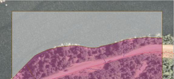
3 Page Site Geology and Soils FIGURE 1 VICINITY MAP SHOWING PROJECT LOCATION The site soils are Wyecreek-Stormking-Pistol complex, 20 to 50 percent north slopes as mapped by the National Resources Conservation Service of the U.S. Department of Agriculture ( This soil unit is formed from colluvium and residuum parent materials, which are derived from basalt and till. 4.0 Geotechnical Exploration 4.1 Soil Observations Visual observation of the site soils in disturbed areas indicate that the surface soils appear to be the mapped Wyecreek extremely gravelly sandy loam. This unit is classified as GM, gravelly sandy loam. 4.2 Vegetation The surface of the soil to the west of the concrete patio foundation is moderately vegetated with ivy and small shrubs. The steep slope to the south of the concrete patio is also well vegetated with ivy, salal, and trees. These trees are quite large, showing long term development in the area. The trees on the steep slope to the south do not show evidence of instability from soil creep or sloughing from saturation.
4 Page 3 FIGURE 2 VEGETATION OF NATIVE SLOPES TO THE SOUTH 4.3 Hydrology and Drainage In the vicinity of the proposed development, no surface depressions or runoff channels were observed. Surface runoff is generally sheet flow, running south towards Lake Sutherlund. According to the NRCS of the USDA, the hydrologic group for the Wyecreek soil unit is C and the drainage class is Well drained. While the soil has a slow infiltration rate, the area is mapped as having a low frequency and duration of wet periods. The Wyecreek soil can become erosive on slopes greater than three (3) degrees when surface runoff is present. 5.0 Recommendations 5.1 Proposed Development The existing concrete patio foundation wall and preliminary fence location is shown in Figure 3. The fence posts were initially installed approximately one (1) foot away from the face of the concrete patio. The posts shown will be removed to accommodate an increased offset distance from the face of the concrete patio foundation wall.
5 Page 4 FIGURE 3 VIEW LOOKING EAST SHOWING THE EXISTING CONCRETE PATIO FOUNDATION WALL The proposed development includes construction of a fence with a height ranging from eight (8) feet to twelve (12) feet. The fence is located a distance of three and a half (3.5) feet from the face of a concrete patio foundation wall. Concrete footings for the fence range in depth from three (3) feet to five (5) with footing widths ranging from eighteen (18) to twenty-four (24) inches. The proposed fence location is now three and a half (3.5) feet away from the face of the wall 5.2 Soil Bearing Pressures Development of the proposed fence includes installation of concrete footings to provide lateral support against wind and dead loads. The depth of embedment for concrete footings varies per post, depending on localized loading conditions. Structural calculations provided by 4 Seasons Engineering show the proposed fence has been designed to resist the given loading conditions based on soil parameters provided in Table Presumptive Load-Bearing Values of Soils of Chapter 18 of the 2009 IBC. Soil parameters of the Wyecreek soil unit observed at the site are consistent with the estimated soil properties selected in the structural report. 5.3 Groundwater According to the NRCS of the USDA, the depth to the water table of the Wyecreek soil unit is greater than six (6) feet. Excavation for fence post footings shall be limited to a maximum of five (5) feet to prevent groundwater intrusion to the excavation. 5.4 Lateral Support
6 Page 5 Excavation near foundations reduces lateral support provided by soil backfill and potentially requires mitigation. The excavation volume per footing is less than 0.6 cubic yards with a minimum offset distance of eight (8) feet, center to center of each footing. The proposed excavation for fence post footings can be expected to have a low to insignificant impact on lateral support to the existing concrete patio foundation. Excavation for footings shall be limited to the dimensions shown in the structural report to prevent loss of lateral support to the concrete patio foundation during excavation. Footings installed in this manner will not cause sliding of native soils or loss of lateral strength support to the concrete patio foundation. Installation of concrete footings for the fence addition will provide additional long term lateral support to the concrete patio foundation due to the advantage of it s inherent high strength material properties opposed to the native soil. 5.5 Slope Stability The native slopes at the project site are stable based upon site observations and available records. Moderate vegetation exists on the native slopes providing protection from erosion. The bulkhead at the toe of the steep slopes at the site guards the shoreline from erosive wave action from Lake Sutherland. Disturbance to the native slopes shall be limited to that which is required to complete installation of the fence addition. Excavation work shall occur between June 1 st and October 31 st to prevent negative impacts from surface water and ground water on slope stability. Excavation shall not occur during any rainfall periods. 5.6 Conclusion It is in our opinion that development of the proposed fence addition as described in this report will not remove lateral support to the existing concrete patio foundation. Site soils can be expected to remain stable during development when carried out within the provisions of this report. The proposed fence addition shall be constructed in conformance with all requirements of the Clallam County Department of Community Development including, but not limited to, the 2009 International Building Code, and applicable clearing, grading, drainage, and erosion control requirements. 6.0 Limitations The observations and conclusions of this report apply only to the subject property and they are not transferable to nearby or adjoining property. This report is the sole property of Stuart McColl and may be used by others only with their permission.
7
8 APPENDIX

9 ' 38'' ' 38'' Page 1 of ' 49'' 48 4' 34'' Soil Map Clallam County Area, Washington 48 4' 48'' 48 4' 33'' ' 12'' ' 12'' ± Longfellow Rd D Map Scale: 1:3,310 if printed on A size (8.5" x 11") sheet Meters Feet W P Olympic National Forest Rd Glen Ln Sportsman Rd Natural Resources Conservation Service Web Soil Survey National Cooperative Soil Survey
10 Page 2 of 3 Soil Map Clallam County Area, Washington MAP LEGEND MAP INFORMATION Area of Interest (AOI) Area of Interest (AOI) Soils Soil Map Units Special Point Features Blowout Borrow Pit Clay Spot Closed Depression Gravel Pit Gravelly Spot Landfill Lava Flow Marsh or swamp Mine or Quarry Miscellaneous Water Perennial Water Rock Outcrop Saline Spot Sandy Spot Severely Eroded Spot Sinkhole Slide or Slip Sodic Spot Spoil Area Stony Spot Very Stony Spot Wet Spot Other Special Line Features Gully Short Steep Slope Other Political Features Cities Water Features Streams and Canals Transportation Rails Interstate Highways US Routes Major Roads Local Roads Map Scale: 1:3,310 if printed on A size (8.5" 11") sheet. The soil surveys that comprise your AOI were mapped at 1:24,000. Warning: Soil Map may not be valid at this scale. Enlargement of maps beyond the scale of mapping can cause misunderstanding of the detail of mapping and accuracy of soil line placement. The maps do not show the small areas of contrasting soils that could have been shown at a more detailed scale. Please rely on the bar scale on each map sheet for accurate map measurements. Source of Map: Natural Resources Conservation Service Web Soil Survey URL: Coordinate System: UTM Zone 10N NAD83 This product is generated from the USDA-NRCS certified data as of the version date(s) listed below. Soil Survey Area: Clallam County Area, Washington Survey Area Data: Version 8, Jul 2, 2012 Date(s) aerial images were photographed: 6/25/2006 The orthophoto or other base map on which the soil lines were compiled and digitized probably differs from the background imagery displayed on these maps. As a result, some minor shifting of map unit boundaries may be evident. Natural Resources Conservation Service Web Soil Survey National Cooperative Soil Survey
11 Soil Map Clallam County Area, Washington Map Unit Legend Clallam County Area, Washington (WA609) Map Unit Symbol Map Unit Name Acres in AOI Percent of AOI 35 Louella gravelly loam, 30 to 65 percent slopes 429D7 Wyecreek-Stormking complex, 50 to 90 percent north slopes % % 499P7 Wyecreek-Stormking-Pistol complex, 20 to 50 percent north slopes % W Water % Totals for Area of Interest % Natural Resources Conservation Service Web Soil Survey National Cooperative Soil Survey Page 3 of 3
12 Map Unit Description: Wyecreek-Stormking-Pistol complex, 20 to 50 percent north slopes Clallam County Area, Washington Clallam County Area, Washington 499P7 Wyecreek-Stormking-Pistol complex, 20 to 50 percent north slopes Map Unit Setting Elevation: 1,740 to 2,600 feet Mean annual precipitation: 60 to 90 inches Mean annual air temperature: 43 to 45 degrees F Frost-free period: 150 to 170 days Map Unit Composition Wyecreek and similar soils: 40 percent Stormking and similar soils: 30 percent Pistol and similar soils: 20 percent Description of Wyecreek Setting Landform: Mountain slopes Parent material: Colluvium and residuum derived from basalt and till Properties and qualities Slope: 20 to 50 percent Depth to restrictive feature: 20 to 40 inches to lithic bedrock Drainage class: Well drained Capacity of the most limiting layer to transmit water (Ksat): Moderately high to high (0.57 to 1.98 in/hr) Depth to water table: More than 80 inches Frequency of flooding: None Frequency of ponding: None Available water capacity: Very low (about 1.7 inches) Interpretive groups Land capability (nonirrigated): 7e Other vegetative classification: western hemlock/oregongrape/ swordfern, Olympic (CHS139) Typical profile 0 to 5 inches: Extremely gravelly sandy loam 5 to 20 inches: Extremely gravelly sandy loam 20 to 32 inches: Extremely cobbly sandy loam 32 to 36 inches: Unweathered bedrock Description of Stormking Setting Landform: Mountain slopes Parent material: Colluvium and residuum derived from basalt and till Properties and qualities Slope: 20 to 50 percent Depth to restrictive feature: 40 to 60 inches to lithic bedrock Drainage class: Well drained Natural Resources Conservation Service Web Soil Survey National Cooperative Soil Survey Page 1 of 3
13 Map Unit Description: Wyecreek-Stormking-Pistol complex, 20 to 50 percent north slopes Clallam County Area, Washington Capacity of the most limiting layer to transmit water (Ksat): Moderately high to high (0.57 to 1.98 in/hr) Depth to water table: More than 80 inches Frequency of flooding: None Frequency of ponding: None Available water capacity: Very low (about 2.3 inches) Interpretive groups Land capability (nonirrigated): 7e Other vegetative classification: western hemlock/oregongrape/ swordfern, Olympic (CHS139) Typical profile 0 to 4 inches: Extremely gravelly sandy loam 4 to 16 inches: Extremely gravelly loam 16 to 30 inches: Extremely gravelly sandy loam 30 to 43 inches: Extremely gravelly sandy loam 43 to 47 inches: Unweathered bedrock Description of Pistol Setting Landform: Mountain slopes Parent material: Colluvium and residuum derived from basalt and till Properties and qualities Slope: 20 to 50 percent Depth to restrictive feature: 20 to 40 inches to densic material Drainage class: Moderately well drained Capacity of the most limiting layer to transmit water (Ksat): Moderately low to moderately high (0.06 to 0.20 in/hr) Depth to water table: About 12 to 36 inches Frequency of flooding: None Frequency of ponding: None Available water capacity: Very low (about 2.9 inches) Interpretive groups Land capability (nonirrigated): 6e Other vegetative classification: western hemlock/oregongrape/ swordfern, Olympic (CHS139) Typical profile 0 to 7 inches: Very gravelly loam 7 to 19 inches: Very gravelly loam 19 to 29 inches: Very gravelly silt loam 29 to 60 inches: Very gravelly silt loam Natural Resources Conservation Service Web Soil Survey National Cooperative Soil Survey Page 2 of 3
14 Map Unit Description: Wyecreek-Stormking-Pistol complex, 20 to 50 percent north slopes Clallam County Area, Washington Minor Components Northpoint Percent of map unit: Data Source Information Soil Survey Area: Clallam County Area, Washington Survey Area Data: Version 8, Jul 2, 2012 Natural Resources Conservation Service Web Soil Survey National Cooperative Soil Survey Page 3 of 3
15
16
17
18 Water Features Clallam County Area, Washington Water Features This table gives estimates of various soil water features. The estimates are used in land use planning that involves engineering considerations. Hydrologic soil groups are based on estimates of runoff potential. Soils are assigned to one of four groups according to the rate of water infiltration when the soils are not protected by vegetation, are thoroughly wet, and receive precipitation from long-duration storms. The four hydrologic soil groups are: Group A. Soils having a high infiltration rate (low runoff potential) when thoroughly wet. These consist mainly of deep, well drained to excessively drained sands or gravelly sands. These soils have a high rate of water transmission. Group B. Soils having a moderate infiltration rate when thoroughly wet. These consist chiefly of moderately deep or deep, moderately well drained or well drained soils that have moderately fine texture to moderately coarse texture. These soils have a moderate rate of water transmission. Group C. Soils having a slow infiltration rate when thoroughly wet. These consist chiefly of soils having a layer that impedes the downward movement of water or soils of moderately fine texture or fine texture. These soils have a slow rate of water transmission. Group D. Soils having a very slow infiltration rate (high runoff potential) when thoroughly wet. These consist chiefly of clays that have a high shrink-swell potential, soils that have a high water table, soils that have a claypan or clay layer at or near the surface, and soils that are shallow over nearly impervious material. These soils have a very slow rate of water transmission. If a soil is assigned to a dual hydrologic group (A/D, B/D, or C/D), the first letter is for drained areas and the second is for undrained areas. Surface runoff refers to the loss of water from an area by flow over the land surface. Surface runoff classes are based on slope, climate, and vegetative cover. The concept indicates relative runoff for very specific conditions. It is assumed that the surface of the soil is bare and that the retention of surface water resulting from irregularities in the ground surface is minimal. The classes are negligible, very low, low, medium, high, and very high. The months in the table indicate the portion of the year in which a water table, ponding, and/or flooding is most likely to be a concern. Water table refers to a saturated zone in the soil. The water features table indicates, by month, depth to the top (upper limit) and base (lower limit) of the saturated zone in most years. Estimates of the upper and lower limits are based mainly on observations of the water table at selected sites and on evidence of a saturated zone, namely grayish colors or mottles (redoximorphic features) in the soil. A saturated zone that lasts for less than a month is not considered a water table. Natural Resources Conservation Service Web Soil Survey National Cooperative Soil Survey Page 1 of 4
19 Water Features Clallam County Area, Washington Ponding is standing water in a closed depression. Unless a drainage system is installed, the water is removed only by percolation, transpiration, or evaporation. The table indicates surface water depth and the duration and frequency of ponding. Duration is expressed as very brief if less than 2 days, brief if 2 to 7 days, long if 7 to 30 days, and very long if more than 30 days. Frequency is expressed as none, rare, occasional, and frequent. None means that ponding is not probable; rare that it is unlikely but possible under unusual weather conditions (the chance of ponding is nearly 0 percent to 5 percent in any year); occasional that it occurs, on the average, once or less in 2 years (the chance of ponding is 5 to 50 percent in any year); and frequent that it occurs, on the average, more than once in 2 years (the chance of ponding is more than 50 percent in any year). Flooding is the temporary inundation of an area caused by overflowing streams, by runoff from adjacent slopes, or by tides. Water standing for short periods after rainfall or snowmelt is not considered flooding, and water standing in swamps and marshes is considered ponding rather than flooding. Duration and frequency are estimated. Duration is expressed as extremely brief if 0.1 hour to 4 hours, very brief if 4 hours to 2 days, brief if 2 to 7 days, long if 7 to 30 days, and very long if more than 30 days. Frequency is expressed as none, very rare, rare, occasional, frequent, and very frequent. None means that flooding is not probable; very rare that it is very unlikely but possible under extremely unusual weather conditions (the chance of flooding is less than 1 percent in any year); rare that it is unlikely but possible under unusual weather conditions (the chance of flooding is 1 to 5 percent in any year); occasional that it occurs infrequently under normal weather conditions (the chance of flooding is 5 to 50 percent in any year); frequent that it is likely to occur often under normal weather conditions (the chance of flooding is more than 50 percent in any year but is less than 50 percent in all months in any year); and very frequent that it is likely to occur very often under normal weather conditions (the chance of flooding is more than 50 percent in all months of any year). The information is based on evidence in the soil profile, namely thin strata of gravel, sand, silt, or clay deposited by floodwater; irregular decrease in organic matter content with increasing depth; and little or no horizon development. Also considered are local information about the extent and levels of flooding and the relation of each soil on the landscape to historic floods. Information on the extent of flooding based on soil data is less specific than that provided by detailed engineering surveys that delineate flood-prone areas at specific flood frequency levels. Natural Resources Conservation Service Web Soil Survey National Cooperative Soil Survey Page 2 of 4
20 Louella B Jan-Dec None Wyecreek C Jan-Dec None Stormking B Jan-Dec None Wyecreek C Jan-Dec None Stormking B Jan-Dec None Pistol C/D January None None C/D February None None C/D March None None C/D April None None C/D November None None C/D December None None Water Jan-Dec None Page 3 of 4 Water Features Clallam County Area, Washington Report Water Features Water Features Clallam County Area, Washington Map unit symbol and soil name Hydrologic group Surface runoff Month Water table Ponding Flooding Upper limit Lower limit Surface depth Duration Frequency Duration Frequency Ft Ft Ft 35 Louella gravelly loam, 30 to 65 percent slopes 429D7 Wyecreek- Stormking complex, 50 to 90 percent north slopes 499P7 Wyecreek- Stormking-Pistol complex, 20 to 50 percent north slopes W Water Natural Resources Conservation Service Web Soil Survey National Cooperative Soil Survey
21 Page 4 of 4 Water Features Clallam County Area, Washington Data Source Information Soil Survey Area: Clallam County Area, Washington Survey Area Data: Version 8, Jul 2, 2012 Natural Resources Conservation Service Web Soil Survey National Cooperative Soil Survey
Soil Map Lewis County, Kentucky (Denham Farm, Sand Hill/Trinity, Lewis Co., KY) Web Soil Survey National Cooperative Soil Survey
 Web Soil Survey National Cooperative Soil Survey") 83 37' 43'' W (Denham Farm, Sand Hill/Trinity, Lewis Co., KY) 83 36' 18'' W 38 40' 37'' N 271500 271700 271900 272100 272300 272500 272700 272900 273100 273300 38 40' 37'' N 38 39' 54'' N 4282900 4283100
83 37' 43'' W (Denham Farm, Sand Hill/Trinity, Lewis Co., KY) 83 36' 18'' W 38 40' 37'' N 271500 271700 271900 272100 272300 272500 272700 272900 273100 273300 38 40' 37'' N 38 39' 54'' N 4282900 4283100
REFERENCE MAPS FEMA FIRM MAP NRCS SOILS MAP
 REFERENCE MAPS FEMA FIRM MAP NRCS SOILS MAP Hydrologic Soil Group-Hillsborough County, Florida (Independence Parkway) 27' 58' 56" 27" 58' 57" 2r 58' 32" 27" 58' 33" Map Scale: 1:5,290 if printed on A size
THE CITY OF THE VILLAGE PLANNED UNIT DEVELOPMENT DESIGN STATEMENT FOR MULFORD ESTATES
 THE CITY OF THE VILLAGE PLANNED UNIT DEVELOPMENT DESIGN STATEMENT FOR MULFORD ESTATES Revised August 18, 2016, August 10, 2016, September 19,2016 Prepared By: Isch and Associates, Inc. 14848 Bristol Park
PHYSICAL SOIL PROPERTIES
 PHYSICAL SOIL PROPERTIES Physical Soil Properties Santa Cruz County, California Scotts Valley Target Physical Soil Properties This table shows estimates of some physical characteristics and features that
Soil Map Lowndes County, Alabama (McEvoy_Gordonsville)
") 524700 525000 525300 525600 525900 526200 3568000 3568000 3567700 3567700 3567400 3567400 3567100 3567100 3566800 3566800 3566500 3566500 3566200 3566200 3565900 3565900 524700 525000 525300 525600 Map
524700 525000 525300 525600 525900 526200 3568000 3568000 3567700 3567700 3567400 3567400 3567100 3567100 3566800 3566800 3566500 3566500 3566200 3566200 3565900 3565900 524700 525000 525300 525600 Map
Watershed Delineation Techniques
 Watershed Delineation Techniques Stacy D. Dehne DATCP Engineer February 2008 1 What Is a Watershed? An Area of Land that Drains to a given location February 2008 2 Contour Map Features Contour Maps: Represent
Drainage Letter for Falcon High School Building Expansion
 August 11, 2017 El Paso County Planning and Community Development Department 2880 International Circle, Suite 110 Colorado Springs, CO 80910 ATTN: RE: Mr. Jeff Rice Drainage Letter for Falcon High School
Custom Soil Resource Report for Isle of Wight County, Virginia, Southampton County, Virginia, and Surry County, Virginia
 United States Department of Agriculture Natural Resources Conservation Service A product of the National Cooperative Soil Survey, a joint effort of the United States Department of Agriculture and other
Site Description. CCR Rule Initial Inflow Design Flood Control System Plan (cont.) 2
 2") Site Description Kentucky Utilities Company (KU) owns and operates Ghent Gypsum Stack, a CCR surface impoundment, at the Ghent Generating Station in Carroll County, Kentucky. The impoundment is permitted
Site Description Kentucky Utilities Company (KU) owns and operates Ghent Gypsum Stack, a CCR surface impoundment, at the Ghent Generating Station in Carroll County, Kentucky. The impoundment is permitted
Hydrologic Soil Group Knowledge Matrix
 Hydrologic Soil Group Knowledge Matrix Refinement Of Soils Parameter For MPCA s Minimum Impact Design Standards Calculator and Stand-Alone Hydrologic Soil Group Determination Funding for this project was
Custom Soil Resource Report for Douglas County, Washington
 United States Department of Agriculture Natural Resources Conservation Service A product of the National Cooperative Soil Survey, a joint effort of the United States Department of Agriculture and other
Stormwater Analysis Report
 Stormwater Analysis Report Solar Panel Array Temple Street (Rt. 14) West Boylston, MA February 24, 216 SITE Prepared for: West Boylston Municipal Lighting Plant 4 Crescent Street West Boylston, MA 1583
STORMWATER MANAGEMENT REPORT FOR THE BORGATA OUTDOOR EVENT AREA POOL ADDITION
 STORMWATER MANAGEMENT REPORT FOR THE BORGATA OUTDOOR EVENT AREA POOL ADDITION City of Atlantic City, Atlantic County, New Jersey Prepared For: Marina District Development Company, LLC One Borgata Way Atlantic
Arvada Plaza Redevelopment. Walmart Store # (Lot 1) Industrial Realty Group, LLC (Lot 2)
 Industrial Realty Group, LLC (Lot 2)") Drainage Analysis Arvada, CO Arvada Plaza Redevelopment Including: Walmart Store #4734-00 (Lot 1) & Industrial Realty Group, LLC (Lot 2) (W 58 th Ave & Independence Street) Arvada, Colorado Preliminary
Drainage Analysis Arvada, CO Arvada Plaza Redevelopment Including: Walmart Store #4734-00 (Lot 1) & Industrial Realty Group, LLC (Lot 2) (W 58 th Ave & Independence Street) Arvada, Colorado Preliminary
Custom Soil Resource Report for Columbus County, North Carolina
 United States Department of Agriculture Natural Resources Conservation Service A product of the National Cooperative Soil Survey, a joint effort of the United States Department of Agriculture and other
Santa Clara Area, California, Western Part
 Santa Clara Area, California, Western Part 101 Urban land, 0 to 2 percent slopes, basins Map Unit Setting Landscape: Alluvial plains, basins Elevation: 0 to 80 feet Mean annual precipitation: 14 to 30
Deep River-Portage Burns Waterway Watershed 2015
 2.4 Soils Soil development is the product of the interaction of parent material, topography, climate, organisms and time. Understanding the types of soils that exist within a watershed and their characteristics
Custom Soil Resource Report for Douglas County, Washington
 United States Department of Agriculture Natural Resources Conservation Service A product of the National Cooperative Soil Survey, a joint effort of the United States Department of Agriculture and other
Custom Soil Resource Report for Pamlico County, North Carolina
 United States Department of Agriculture Natural Resources Conservation Service A product of the National Cooperative Soil Survey, a joint effort of the United States Department of Agriculture and other
Custom Soil Resource Report for Polk County, Wisconsin
 United States Department of Agriculture Natural Resources Conservation Service A product of the National Cooperative Soil Survey, a joint effort of the United States Department of Agriculture and other
Custom Soil Resource Report for Colquitt and Cook Counties, Georgia
 United States Department of Agriculture Natural Resources Conservation Service A product of the National Cooperative Soil Survey, a joint effort of the United States Department of Agriculture and other
Alapaha Tract. Alapaha Tract. Berrien County GA Acres Par LL 320 LD 5. Date: 6/6/2017. TractName
 The 996 Planted Slash was st thinned in 0 TractName Alapaha inch equals 74 miles in = 44,786 ft 0 0 60 Miles :,77,40 The 996 Planted Slash was st thinned in 0 TractName Alapaha inch equals miles in = 6,7
APPENDIX I LESA MODELS
 APPENDIX I LESA MODELS LESA ASSESSMENT SEVILLE 4 SOLAR PROJECT HORIZONTAL SINGLE-AXIS TRACKING ARRAY (T16S, R12E, S25, SBB&M) IMPERIAL COUNTY, CALIFORNIA July 2017 EMA Report No. 2375-01 Prepared for:
Chapter 2: Conditions in the Spring Lake Watershed related to Stormwater Pollution
 Chapter 2: Conditions in the Spring Lake Watershed related to Stormwater Pollution To identify the primary causes and consequences of stormwater discharges to Spring Lake and its adjoining waterbodies,
Custom Soil Resource Report for St. Lucie County, Florida
 United States Department of Agriculture Natural Resources Conservation Service A product of the National Cooperative Soil Survey, a joint effort of the United States Department of Agriculture and other
Web Soil Survey National Cooperative Soil Survey
 99 52' 37'' W Yields of Irrigated Crops (Component): Cotton lint (Lbs) Haskell County, Texas 99 51' 40'' W 33 21' 4'' N 418500 418600 418700 418800 418900 419000 419100 419200 419300 419400 419500 419600
LESA ASSESSMENT LAUREL SOLAR PROJECT (T16S, R12E, S26, SBB&M)
") LESA ASSESSMENT LAUREL SOLAR PROJECT (T16S, R12E, S26, SBB&M) IMPERIAL COUNTY, CALIFORNIA May 2017 EMA Report No. 2377-01 Prepared for: 90FI 8me LLC 111 Woodmere Road, Suite 250 Folsom, CA 95630 ENVIRONMENTAL
LESA ASSESSMENT LAUREL SOLAR PROJECT (T16S, R12E, S26, SBB&M) IMPERIAL COUNTY, CALIFORNIA May 2017 EMA Report No. 2377-01 Prepared for: 90FI 8me LLC 111 Woodmere Road, Suite 250 Folsom, CA 95630 ENVIRONMENTAL
Land Evaluation and Site Assessment Model
 Land Evaluation and Site Assessment Model Citizens Imperial Solar, LLC Project Imperial County, CA June 6, 2018 This page is intentionally blank. Land Evaluation and Site Assessment Model Citizens Imperial
Custom Soil Resource Report for Wright County, Minnesota
 United States Department of Agriculture Natural Resources Conservation Service A product of the National Cooperative Soil Survey, a joint effort of the United States Department of Agriculture and other
APPENDIX E. LESA Models
 APPENDIX E LESA Models LESA ASSESSMENT CALEXICO SOLAR FARM I PHASE A PROJECT AREA CALEXICO SOLAR FARM I PHASE A PROJECT (SW/4 Section 13, S/2 Section 14, S/2 NE/4 Section 15, NW/4 Section 15, T17S, R13E,
Custom Soil Resource Report for Logan County, Oklahoma
 United States Department of Agriculture Natural Resources Conservation Service A product of the National Cooperative Soil Survey, a joint effort of the United States Department of Agriculture and other
Mapping and Understanding YOUR LAKE S WATERSHED By: Tony Groves, Pam Tyning, and Tory Meyers Water Resources Group, Progressive AE
 By: Tony roves, Pam Tyning, and Tory Meyers Water Resources roup, Progressive A What is a Watershed? A watershed is the land area surrounding a lake from which water drains to the lake. The imaginary line
Custom Soil Resource Report for St. Lucie County, Florida Gopherbroke Farms
 United States Department of Agriculture Natural Resources Conservation Service A product of the National Cooperative Soil Survey, a joint effort of the United States Department of Agriculture and other
NRCS Soils Information and Maps. Appendix F
 NRCS Soils Information and Maps Appendix F United States Department of Agriculture Natural Resources Conservation Service A product of the National Cooperative Soil Survey, a joint effort of the United
Dye Creek Orchards Los Molinos, California
 AG-LAND INVESTMENT BROKERS 275Sale Lane / P. O. Box 896 Red Bluff, CA 96080 530.529.4400 office / 530.527.5042 fax Dye Creek Orchards Los Molinos, California Listing Price: $1,950,000. Seller financing
Ponds: planning, design, and construction
 Ponds: planning, design, and construction Ponds for many purposes: Fish Production Recreation Water Supply Esthetics Wildlife Habitat Natural ponds: Formed in natural depressions in the landscape Not man-made
This page intentionally left blank
 REFERENCE DOCUMENTS This page intentionally left blank TABLE OF CONTENTS REFERENCE DOCUMENTS REFERENCE DOCUMENT A: MEAN SEASONAL PRECIPITATION MAP R 1 REFERENCE DOCUMENT B: K FACTOR R 2 REFERENCE DOCUMENT
Custom Soil Resource Report for Dallam County, Texas
 United States Department of Agriculture Natural Resources Conservation Service A product of the National Cooperative Soil Survey, a joint effort of the United States Department of Agriculture and other
Custom Soil Resource Report for Okeechobee County, Florida
 United States Department of Agriculture Natural Resources Conservation Service A product of the National Cooperative Soil Survey, a joint effort of the United States Department of Agriculture and other
STORMWATER POLLUTION PREVENTION PLAN (SWPPP)
") SIEMENS INDUSTRY, INC. STORMWATER POLLUTION PREVENTION PLAN (SWPPP) COLUMBIA UNIVERSITY/SUN EDISON REMOTE METERING SOLAR ENERGY PROJECT JOHNSON FARM, 121 JOHNSON ROAD CHESTER, NEW YORK 10918 TAX LOT SECTION
SIEMENS INDUSTRY, INC. STORMWATER POLLUTION PREVENTION PLAN (SWPPP) COLUMBIA UNIVERSITY/SUN EDISON REMOTE METERING SOLAR ENERGY PROJECT JOHNSON FARM, 121 JOHNSON ROAD CHESTER, NEW YORK 10918 TAX LOT SECTION
Appendix 10-A. Optional Recharge Volume Approach
 Appendix 10-A Optional Recharge Volume Approach Table of Contents APPENDIX SECTION HEADINGS 10-A.0 INTRODUCTION 10-A-2 10-A.1 Horsely Method for Determining Recharge Volumes 10-A-2 10-A.1.1 Basis for Determining
Loam Ridge Almond Orchard
 AG-LAND Investment Brokers 645 Antelope Blvd., Suite 17 PO Box 896 Red Bluff, CA 96080 530-529-4400 Fax 530-527-5042 Loam Ridge Almond Orchard Contact: AG-LAND Investment Brokers Prepared by FSA Date:
FEMA (from current study - not yet adopted) Flow Data Table 2 Summary of Discharges Floodway Data
 Flow Data Table 2 Summary of Discharges Floodway Data") Table of Contents Report Cover Table of Contents General Information Methodology Existing Condition Analysis Proposed Condition Analysis Summary Conclusions and Recommendations Appendix Maps and Exhibits
Table of Contents Report Cover Table of Contents General Information Methodology Existing Condition Analysis Proposed Condition Analysis Summary Conclusions and Recommendations Appendix Maps and Exhibits
LESA ASSESSMENT MOUNT SIGNAL SOLAR FARM I PROJECT AREA
 LESA ASSESSMENT MOUNT SIGNAL SOLAR FARM I PROJECT AREA MOUNT SIGNAL SOLAR FARM I PROJECT (SW/4 Section 16, S/2 Section 15, NE/4 Section 14 (portion), N/2 Section 13 (portion) and SE/4 Section 13, T17S,
AG-LAND Investment Brokers 275 Sale Lane Red Bluff, CA Fax Paradox Seed Mother Orchard Red Bluff, CA
 AG-LAND Investment Brokers 275 Sale Lane Red Bluff, CA 96080 530-529-4400 Fax 530-527-5042 Paradox Seed Mother Orchard Red Bluff, CA AG-LAND INVESTMENT BROKERS 275 Sale Lane / P. O. Box 896 Red Bluff,
Civil Engineering Land Surveying Wetland Science
 Civil Engineering Land Surveying Wetland Science July 5, 2017 Town of Littleton Conservation Commission c/o Amy Green, Conservation Coordinator Shattuck Street Municipal Building 37 Shattuck Street Littleton,
HARVEST PARK/ZIEGLER MIXED USE LOT 2 CITY OF FORT COLLINS, CO
 EROSION CONTROL REPORT / STORMWATER MANAGEMENT PLAN FOR HARVEST PARK/ZIEGLER MIXED USE LOT 2 CITY OF FORT COLLINS, CO Prepared by: Interwest Consulting Group 1218 West Ash, Suite C Windsor, Colorado 80550
Custom Soil Resource Report for Okeechobee County, Florida
 United States Department of Agriculture Natural Resources Conservation Service A product of the National Cooperative Soil Survey, a joint effort of the United States Department of Agriculture and other
LAKE COUNTY HYDROLOGY DESIGN STANDARDS
 LAKE COUNTY HYDROLOGY DESIGN STANDARDS Lake County Department of Public Works Water Resources Division 255 N. Forbes Street Lakeport, CA 95453 (707)263-2341 Adopted June 22, 1999 These Standards provide
Introduction. Figure 1 ZONING MAP
 Introduction Weatherly McNally & Dixon, PLC is evaluating the property located at 7620 Sawyer Brown Road in Nashville, Tennessee, for its highest and best use of development. The property is currently
CHAPTER 7 PHYSICAL INVENTORY OF THE CITY
 CHAPTER 7 PHYSICAL INVENTORY OF THE CITY Chapter 7: Physical Inventory of the City 39 This page intentionally left blank. Chapter 7: Physical Inventory of the City 40 SECTION 1 PHYSICAL SETTING While communities
Names: ESS 315. Lab #6, Floods and Runoff Part I Flood frequency
 Names: ESS 315 Lab #6, Floods and Runoff Part I Flood frequency A flood is any relatively high flow of water over land that is not normally under water. Floods occur at streams and rivers but can also
COWLITZ COUNTY DEPARTMENT OF BUILDING AND PLANNING
 COWLITZ COUNTY DEPARTMENT OF BUILDING AND PLANNING GENERAL GRADING REQUIREMENTS GRADING STANDARDS Unless otherwise recommended in a soils engineering or engineering geology report, approved by the County,
In preparation for constructing buildings on a property, the builder. Site Preparation CHAPTER
 CHAPTER 3 Site Preparation In preparation for constructing buildings on a property, the builder must consider a number of factors related to code requirements. The buildings must be located according to
Pinheiro Ranch 55+/- Acres Orchard Development Ground Orland, CA. Presented By:
 Pinheiro Ranch 55+/- Acres Orchard Development Ground Orland, CA Presented By: Pinheiro Ranch 55+/- Acres Orchard Development Ground Orland, CA Location: This property is located on the SE corner of Road
March 28, Port of Kalama Mr. Jacobo Salan 380 West Marine Drive Kalama, Washington 98625
 11917 NE 95 th Street, Vancouver, Washington 98682 Phone: 360-823-2900, Fax: 360-823-2901 March 28, 2014 Port of Kalama Mr. Jacobo Salan 380 West Marine Drive Kalama, Washington 98625 Re: Construction
GRADING, FILL, EXCAVATION AND LANDSCAPING 2012 EDITION
 CHAPTER 23.105 GRADING, FILL, EXCAVATION AND LANDSCAPING 2012 EDITION Sections 23.105.101 General... 1 23.105.102 Definitions... 1 23.105.103 Permits required... 3 23.105.104 Hazards.... 4 23.105.105 Permit
TIERRA SOUTH FLORIDA, INC. Geotechnical Engineering / Material Testing / Inspection Services
 TIERRA SOUTH FLORIDA, INC. Geotechnical Engineering / Material Testing / Inspection Services March 11, 2016 Kimley-Horn 1920 Wekiva Way Suite 200 West Palm Beach, Fl. 33411 Attn: Matthew B. Fursetzer,
 Attachment E Loam Approval Package and Soil Blending Letter (EI) EcoTec, Inc. ENVIRONMENTAL CONSULTING SERVICES 102 Grove Street Worcester, MA 01605-2629 508-752-9666 / Fax: 508-752-9494 May 15, 2013 Michele
SOILS INFORMATION FOR GEORGIA
 APPENDIX SOILS INFORMATION FOR GEORGIA (Source: Manual for Erosion and Sediment Control in Georgia, Fifth Edition, 2000) B Appendix B-1 SOILS INFORMATION The soils information in Appendix B has been assembled
The Big Picture SOILS, WETLANDS AND DEVELOPMENT SOILS OVERVIEW BRUCE BARBER. PWS, Soil Scientist Certified Ecologist CORNERSTONE ASSOCIATES
 SOILS, WETLANDS AND DEVELOPMENT BRUCE BARBER PWS, Soil Scientist Certified Ecologist CORNERSTONE ASSOCIATES 1770 CENTRAL STREET YORKTOWN HEIGHTS NY 10598 PHONE: (914) 962-7733 FAX: (914) 962-0330 EMAIL:
Mule Ranch - Dorris, CA 1,234 +/- acres, Siskiyou County
 AG-LAND Investment Brokers 275 Sale Lane Red Bluff, CA 96080 530-529-4400 Fax 530-527-5042 Mule Ranch - Dorris, CA 1,234 +/- acres, Siskiyou County AG-LAND INVESTMENT BROKERS 275 Sale Lane / P. O. Box
Stormwater Erosion Control & Post-Construction Plans (Stormwater Quality Plans)
") Stormwater Erosion Control & Post-Construction Plans (Stormwater Quality Plans) Allen County Stormwater Plan Submittal Checklist The following items must be provided when applying for an Allen County Stormwater
Stormwater Erosion Control & Post-Construction Plans (Stormwater Quality Plans) Allen County Stormwater Plan Submittal Checklist The following items must be provided when applying for an Allen County Stormwater
Gonsalves Ranch, 756 +/- Total Acres Red Bluff, California
 AG-LAND INVESTMENT BROKERS 275 Sale Lane, Suite 2 / P. O. Box 896 Red Bluff, CA 96080 530.529.4400 office / 530.527.5042 fax Gonsalves Ranch, 756 +/- Total Acres Red Bluff, California Listing Price: $675,000.
Ponds. Pond A water impoundment made by excavating a pit, or constructing a dam or an embankment.
 POND SITE SELECTION AND CONSTRUCTION Uses, Planning, & Design David Krietemeyer Area Engineer USDA-NRCS June 20, 2008 Uses Considerations for Location of Commonly Used Terms Pond A water impoundment made
NEW CASTLE CONSERVATION DISTRICT. through. (Name of Municipality) PLAN REVIEW APPLICATION DRAINAGE, STORMWATER MANAGEMENT, EROSION & SEDIMENT CONTROL
 PLAN REVIEW APPLICATION DRAINAGE, STORMWATER MANAGEMENT, EROSION & SEDIMENT CONTROL") NEW CASTLE CONSERVATION DISTRICT through (Name of Municipality) PLAN REVIEW APPLICATION DRAINAGE, STORMWATER MANAGEMENT, EROSION & SEDIMENT CONTROL Office use only: Received by Municipality: Received by
NEW CASTLE CONSERVATION DISTRICT through (Name of Municipality) PLAN REVIEW APPLICATION DRAINAGE, STORMWATER MANAGEMENT, EROSION & SEDIMENT CONTROL Office use only: Received by Municipality: Received by
Commonwealth of Massachusetts City/Town of Form 11 - Soil Suitability Assessment for On-Site Sewage Disposal. Street Address Map/Lot #
 A. Facility Information Owner Name Street Address Map/Lot # City State Zip Code B. Site Information 1. (Check one) New Construction Upgrade Repair 2. Published Soil Survey Available? Yes No If yes: Year
Appendix M Land Evaluation and Site Assessment (Calipatria I, Midway I and Midway II)
") Appendix M Land Evaluation and Site Assessment (Calipatria I, Midway I and Midway II) LESA ASSESSMENT CALIPATRIA SOLAR FARM I PROJECT AREA CALIPATRIA SOLAR FARM I PROJECT (Section 10 (portion), T12S, R14E,
Appendix M Land Evaluation and Site Assessment (Calipatria I, Midway I and Midway II) LESA ASSESSMENT CALIPATRIA SOLAR FARM I PROJECT AREA CALIPATRIA SOLAR FARM I PROJECT (Section 10 (portion), T12S, R14E,
Appendix E Preliminary Jurisdictional Wetland Delineation Report, JYL 2008
 Appendix E Preliminary Jurisdictional Wetland Delineation Report, JYL 2008 PRELIMINARY JURISDICTIONAL WETLAND DELINEATION REPORT A portion of USS 3819 and 2664: Horton Lot and Statter Harbor Juneau, Alaska
APPENDIX J CRYSTAL GEYSER ONSITE IRRIGATION SYSTEM TECHNICAL MEMORANDUM
 APPENDIX J CRYSTAL GEYSER ONSITE IRRIGATION SYSTEM TECHNICAL MEMORANDUM DRAFT TECHNICAL MEMORANDUM Crystal Geyser Onsite Irrigation System PREPARED FOR: PREPARED BY: REVIEWED BY: Richard Weklych/CGWC Barbara
ARTICLE IV: DEVELOPMENT STANDARDS GRADING AND DRAINAGE
 ARTICLE IV: DEVELOPMENT STANDARDS IV-63 410 GRADING AND DRAINAGE 410-1 General Provisions 410-1.1 All grading and drainage activities are to occur pursuant to the provisions of Chapter 14.12 of the Washington
Instructions for Notice of Ground Disturbance Form:
 Instructions for Notice of Ground Disturbance Form: Prior to beginning any ground disturbance activity or finalizing your storm water plan, submit a completed 2 page Notice of Ground Disturbance Form to
ARTICLE 6 EXCAVATION OF MINERAL MATERIALS
 ARTICLE 6 EXCAVATION OF MINERAL MATERIALS SECTION 1. PURPOSE All excavations, extraction of materials and minerals, open pits and impounding of waters hereafter established or enlarged shall conform to
Forest Glen Recreation Residence Septic System Improvements Soils Report Shasta-Trinity National Forest January 2011
 Terrain Background: Soil map units: Forest Glen Recreation Residence Septic System Improvements Soils Report Shasta-Trinity National Forest January 2011 32 Deadwood very gravelly loam, 40 to 60% slopes
Environmental Resource Inventories. What are ERIs? Significance of information How to use them
 Environmental Resource Inventories What are ERIs? Significance of information How to use them Environmental Resource Inventory - ERI Compiled by the environmental commission Information about the natural
Custom Soil Resource Report for Ocean County, New Jersey
 United States Department of Agriculture Natural Resources Conservation Service A product of the National Cooperative Soil Survey, a joint effort of the United States Department of Agriculture and other
The soil is a very. The soil can. The manure. Soil Characteristics. effective manure treatment system if manures are applied at the proper rate.
 The soil is a very effective manure treatment system if manures are applied at the proper rate. The soil can filter pollutants and prevent them from reaching groundwater. The manure application rate should
A. 1. Provide a description of each of the soils indicated on Map E utilizing the following format:
 15. SOILS A. 1. Provide a description of each of the soils indicated on Map E utilizing the following format: Table 15.A.1 Soil Descriptions Soil Name Soil Description Seasonal High Water Table Depth Duration
CCR Rule Operating Criteria Closure Plan
 CCR Rule Operating Criteria 257.102 Closure Plan FGD Pond 2 Jim Bridger Plant Point of Rocks, Wyoming PREPARED FOR PacifiCorp 1407 West North Temple Salt Lake City, UT 84116 (801) 521-0376 Fax (801) 220-4748
MINNEHAHA CREEK WATERSHED DISTRICT BOARD OF MANAGERS REVISIONS PURSUANT TO MINNESOTA STATUTES 103D.341. Adopted April 24, 2014 Effective June 6, 2014
 MINNEHAHA CREEK WATERSHED DISTRICT BOARD OF MANAGERS REVISIONS PURSUANT TO MINNESOTA STATUTES 103D.341 Adopted April 24, 2014 Effective June 6, 2014 EROSION CONTROL RULE 1. POLICY. It is the policy of
Standards for Soil Erosion and Sediment Control in New Jersey May 2012 STANDARD FOR GRASSED WATERWAYS. Definition. Purpose
 STANDARD FOR GRASSED WATERWAYS Definition A natural or constructed watercourse shaped or graded in earth materials and stabilized with suitable vegetation for the safe conveyance of runoff water. Purpose
Custom Soil Resource Report for Kent County, Michigan
 United States Department of Agriculture Natural Resources Conservation Service A product of the National Cooperative Soil Survey, a joint effort of the United States Department of Agriculture and other
CORNERSTONE RIVER VALLEY VILLAGE FILING NO. 1 STORMWATER MANAGEMENT PLAN
 CORNERSTONE RIVER VALLEY VILLAGE FILING NO. 1 STORMWATER MANAGEMENT PLAN SITUATED IN THE SW ¼ OF SECTION 18, T.2S., R.67W., OF THE 6 TH P.M. COUNTY OF ADAMS, STATE OF COLORADO PREPARED FOR: Thornton Cornerstone
AG-LAND Investment Brokers 275 Sale Lane Red Bluff, CA Fax Corning Eucalyptus Farm
 AG-LAND Investment Brokers 275 Sale Lane Red Bluff, CA 96080 530-529-4400 Fax 530-527-5042 Corning Eucalyptus Farm Tehama County,, California 1 of 6 deep irrigation wells Drip tubing rolled at the edge
Web Soil Survey National Cooperative Soil Survey
 289300 289700 290100 290500 83 12' 5'' W 83 13' 37'' W Farmland Classification Ben Hill and Irwin Counties, Georgia 290900 291300 31 46' 8'' N 3514000 3514000 3514400 3514400 3514800 3514800 3515200 3515200
SOUTH FLORIDA WATER MANAGEMENT DISTRICT. Question 13: Wetlands
 SOUTH FLORIDA WATER MANAGEMENT DISTRICT Question 13: Wetlands 1. The wetland responses and topographical data provided in the ADA for the 520- acre project site are conceptual in nature. The referenced
How & Where does infiltration work? Context: Summary of Geologic History Constraints/benefits for different geologic units
 Associated Earth Sciences, Inc. Associated Earth Sciences, Inc. Presented by: Matthew A. Miller, PE April 23, 2013 How & Where does infiltration work? Context: Summary of Geologic History Constraints/benefits
Very slight to negligible limitations no special land management practices required.
 Land Capability Classes Land and Soil Capability Class 1 Class 1 Definition Very slight to negligible limitations no special land management practices required. On-site impact of land management practices
STANDARD GRADING AND SOIL EROSION & SEDIMENT CONTROL PLAN FOR SINGLE LOT SINGLE FAMILY RESIDENTIAL CONSTRUCTION AND MINOR EARTH DISTURBANCES
 DIVISION OF ENGINEERING & CONSTRUCTION MANAGEMENT PLAN REVIEW DEPARTMENT WASHINGTON COUNTY SOIL CONSERVATION DISTRICT 1260 Maryland Avenue, Suite 101 Hagerstown, MD 21740 Telephone: (301) 797-6821, Ext.
AMERICAN ELECTRIC POWER (SWEPCO)
") 2016 DAM & DIKE INSPECTION REPORT ASH PONDS GERS-16-163 WELSH POWER PLANT AMERICAN ELECTRIC POWER (SWEPCO) CASON, TEXAS NATIONAL INVENTORY NO. TX4357 PREPARED BY GEOTECHNICAL ENGINEERING AEP SERVICE CORPORATION
2016 DAM & DIKE INSPECTION REPORT ASH PONDS GERS-16-163 WELSH POWER PLANT AMERICAN ELECTRIC POWER (SWEPCO) CASON, TEXAS NATIONAL INVENTORY NO. TX4357 PREPARED BY GEOTECHNICAL ENGINEERING AEP SERVICE CORPORATION
SAMPLE DRAINAGE STATEMENT
 Firm Name & Logo Hidalgo County Drainage District No. 1 Drainage Statement Subdivision Name Hidalgo County, Texas Prepared By: Firm's Name Address City, State, Zip Telephone Fax Email Date SAMPLE DRAINAGE
Dairyville Irrigated Pasture & Home. Los Molinos, CA
 Dairyville Irrigated Pasture & Home Los Molinos, CA AG-LAND INVESTMENT BROKERS 275 Sale Lane, Suite 2 / P. O. Box 896 Red Bluff, CA 96080 530.529.4400 office / 530.527.5042 fax 68 th Avenue Irrigated Pasture
SUPPORTING DOCUMENT STORMWATER BEST MANAGEMENT PRACTICE (BMP) INFEASIBILITY WORKSHEET FOR ON-SITE STORMWATER MANAGEMENT
 INFEASIBILITY WORKSHEET FOR ON-SITE STORMWATER MANAGEMENT") SUPPORTING DOCUMENT STORMWATER BEST MANAGEMENT PRACTICE (BMP) INFEASIBILITY WORKSHEET FOR ON-SITE STORMWATER MANAGEMENT All Best Management Practices (BMPs) are considered feasible until demonstrated otherwise.
SUPPORTING DOCUMENT STORMWATER BEST MANAGEMENT PRACTICE (BMP) INFEASIBILITY WORKSHEET FOR ON-SITE STORMWATER MANAGEMENT All Best Management Practices (BMPs) are considered feasible until demonstrated otherwise.
STORMWATER AND EROSION CONTROL PERMIT
 STORMWATER MANAGEMENT AND EROSION CONTROL PERMIT INSTRUCTIONS AND INFORMATION Any project that involves the disturbance of ANY quantity of land requires the applicant to receive approval for the project
Grading & Excavation Information Application & Checklist
 Grading & Excavation Information Application & Checklist Yakima County Public Services ~ Building & Fire Safety Division 128 North 2 nd Street, Yakima, WA 98901 ~ Office (509) 574-2300 Building & Fire
STORMWATER AND EROSION CONTROL PERMIT
 STORMWATER MANAGEMENT AND EROSION CONTROL PERMIT INSTRUCTIONS AND INFORMATION Any project that involves the disturbance of ANY quantity of land requires the applicant to receive approval for the project
GRADING, EROSION AND SEDIMENTATION CONTROL
 SECTION 500 GRADING, EROSION AND SEDIMENTATION CONTROL 501 Erosion and Sedimentation Control Plan All engineering plans for projects that propose to construct new, or modify existing drainage facilities,
The glenlivet farm and refuge An agricultural and recreational investment opportunity.
 offered for sale The glenlivet farm and refuge An agricultural and recreational investment opportunity. 3,106 (+/- sq. ft.) lodge situated on a 304 (+/-) acre farm/waterfowl refuge Arkansas County, Arkansas
Module 3: Rainfall and Hydrology for Construction Site Erosion Control
 Module 3: Rainfall and Hydrology for Construction Site Erosion Control Robert Pitt Department of Civil, Construction, and Environmental Engineering University of Alabama Tuscaloosa, AL Rainfall and Hydrology
RI Site Specific Soil Mapping Standards and Procedures
 RI Site Specific Soil Mapping Standards and Procedures Understanding Hydrologic Soil Groups and Site Specific Mapping URI Coastal Institute, Kingston June 28 th 2012 Jillian Phillips URI Cooperative Extension