UrtheCast s Vision for the Democratization of Earth Observation
|
|
|
- Kory Thompson
- 6 years ago
- Views:
Transcription

1 UrtheCast s Vision for the Democratization of Earth Observation Fabrizio Pirondini, CEO Deimos Imaging & GM Earth Observation UrtheCast Geospatial World Forum 2016, Rotterdam, The Netherlands, 23 May 2016

2 The Big Picture We re on the threshold of a new era: Huge value will soon be unlocked by Earth Observation systems and services. Space-based services reach take-off when integrated into much larger industries The key: productivity gains when space becomes an embedded utility Satellite Communications Navigation Earth Observation 2

3 From Remote Sensing to Market-Driven GeoAnalytics
 Market Split (2015) US Defense: 24% Non-US Defense: 38% Non-Defense Markets:")
4 Projected Growth of EO Imagery Market Earth Observation Data Sales (Optical + Radar) Market Split (2015) US Defense: 24% Non-US Defense: 38% Non-Defense Markets: 38% 4
5 The Geoanalytics Market: Big Data, Big Growth An emerging $ 24 B/yr market growing to $ 72 B/yr in 2020* Total Addressable Market (TAM)* = a subsector of the Big Data market 1 Today B2G ~ US$ 3-5B Traditional EO Imagery, information and traditional value-added applications 2 Emerging B2B Tens of US$ Billions Big Data Analytics Highly-derived geoanalytics services and applications 3 Long-term B2C US$? Long-tail Web and Media Applications Highly-derived Information services And EO-embedded Native apps very large and underserved markets * MarketandMarkets Feb
6 Growing Geoanalytics Market Opportunities Emerging in all sectors of human endeavour and evolving rapidly Forestry Environment Agriculture Water & Trading / Irrigation Commodities Management Natural Resources Infrastructure Transportation Urban Planning News Events Disasters Public Safety NGOs Intelligence Defense Insurance

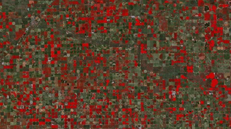
7 Geoanalytics Opportunity in Agriculture Emerging opportunity ~$20-25B/yr TAM Monsanto estimates that ~1 billion farm acres globally could support an estimated $20-$25/acre of geoanalytics services and products. Remotely-sensed data is currently estimated to support and improve over 40 separate and critical agricultural related decisions, including: seed selection, weed control, insect control, fertilizers usage, tillage, crop diagnostics, harvest, etc. According to a survey of 2015 InfoAg attendees, nearly half (47%) said that they plan to increase their investments in remote imagery services, citing real-time data and higher yields as the primary factors influencing its adoption by farmers. 7
8 Opportunity in Water & Irrigation Management Emerging ~$10-15B/yr TAM Current geoanalytics partners have validated this opportunity by harnessing our current geospatial datasets Remotely-sensed data is currently supporting substantial water and irrigation management savings, supporting an estimated TAM of 10-15B/yr 8
 Easy-to-use value-added third-party products and services with imbedded geoanalytics")
9 Unlocking the Large Emerging Geoanalytics Market Frequent global coverage of consistent, high-quality data Accessible data (low cost and API accessible) Easy-to-use value-added third-party products and services with imbedded geoanalytics capabilities 9

10 UrtheCast and the Democratization of EO


11 UrtheCast + Deimos Imaging We provide a unique portfolio of EO products and services, and it s evolving Theia Iris Deimos-1 Deimos-2 UrthePlatform 150 People Ground Stations 100 People 11


12 A Vertically-Integrated EO System A space-based Geospatial Big Data collection, processing, and information management system completely vertically-integrated. Upstream Satellites Midstream UrthePipeline Ground Segment Downstream UrthePlatform 12
13 Experience Leads Us to Develop Tailored Systems Market-driven progression of sensors and infrastructure, based on three synergetic pillars: Theia Deimos-1 Iris Deimos-2 Cloud Platform In-House Archive UrtheDaily TM Constellation OptiSAR TM Constellation UrthePlatform 13

14 The UrtheDaily TM Constellation All the World, Everyday, at 10:30 AM, at 5m/pixel, through a user-friendly cloud platform 8 satellites to produce consistent, reliable, daily delivery of 140 M km 2 of multispectral imagery Product: Multispectral, 5m/pixel high-quality imagery, with full global daily coverage Service: Through the cloud, and via APIs, all based on the UrthePlatform UrtheDaily TM will enable daily, global change detection and analysis at unprecedented scale. Developed following years of study, as natural evolution of the Deimos-1 and Theia experiences Incorporates market lessons learned via current assets and customers An unprecedented and disruptive product/service, tailored for GeoAnalytics UrtheDaily TM operations could start as early as 2018 BEST COVERAGE 14
 + Optical (50 cm) This arrangement")

15 The OptiSAR TM Constellation The World s first fully-integrated constellation of Optical and SAR satellites 16 satellites in two orbit planes Satellites are arranged in 8 pairs: SAR (X+L bands) + Optical (50 cm) This arrangement allows for: Very high assured (day/night, cloudy or not) revisit worldwide Imaging of the same location with SAR and Optical Optimized multispectral imaging through cloud avoidance OptiSAR TM operations could start as early as 2020 BEST REVISIT 15
16
17 Resolution A Combined Offering that s Unmatched With OptiSAR TM and UrtheDaily TM : Resolution In the highest class (OptiSAR) HIGH Revisit By far the highest (OptiSAR + UrtheDaily) Coverage By far the highest (OptiSAR + UrtheDaily) LOW LOW Revisit HIGH LOW HIGH 17


18 UrthePlatform TM : Unleashing EO Big Data Available NOW, with 5 main APIs and data from multiple satellites UrthePlatform End User Dashboard Welcome Page UrthePlatform End User Tools Archive Browser 18
19 Our Vision of the Democratization of EO Provide unhindered and near universal access of EO imagery and data at affordable price point in formats and on platforms that do not require expertise within an eco-system that attracts third-party investment and innovation (Apps) that significantly broaden the utility of the data for organizations and individuals 19
20 From Earth Observation to GeoAnalytics A source-agnostic, cloud-based ecosystem for ingesting, displaying, exploiting, and distributing satellite data, imagery, and video to monitor our constantly-changing world. Forestry Environment Agriculture Water Trading / Commodities Construction Infrastructure Transportation Urban Planning News Events Disasters Public Safety NGOs Intelligence Defense Insurance 20
21 Conclusions
Geospatial Cloud Analytics: The Confluence of Commercial Space and the Computing Revolution
 Geospatial Cloud Analytics: The Confluence of Commercial Space and the Computing Revolution Dolores Shaffer, Science and Technology Associates for Dr. Joseph B. Evans, Program Manger, DARPA/STO Chesapeake
eo4all The European EO Services Industry
 eo4all @ESA, Pío XI Glacier, Chile @Benjamin Grant/Google Earth/Digital Globe Man must rise above Earth to the top of the atmosphere & beyond, for only then Industry will he fully understand the world
INTRODUCTION TO THINGWORX. Petr Holy Head of Sales Eastern Europe. February 2 nd, 2016
 INTRODUCTION TO THINGWORX Petr Holy Head of Sales Eastern Europe February 2 nd, 2016 Who is ThingWorx? A business unit of PTC 800+ employees dedicated to IoT Thousands of ThingWorx-compatible partners
Remote Sensing for Monitoring USA Crop Production: What is the State of the Technology
 Remote Sensing for Monitoring USA Crop Production: What is the State of the Technology Monitoring Food Security Threats from Space - A CELC Seminar Centurion, SA 21 April 2016 David M. Johnson Geographer
Big Data Analytics for Agriculture
 Big Data Analytics for Agriculture Introduction Company Vision SatSure is a large area analytics company creating data-driven solutions for decision intelligence Making the world an alternate data-driven
World population to grow from 7.0 billion to 9.2 billion by Diets are improving with rapid growth of middle class
 AGRIBUSINESS AND FOOD PRODUCTION ARE AMONG THE GREATEST GROWTH INDUSTRIES OF OUR ERA World population to grow from 7.0 billion to 9.2 billion by 2050 Global food production will need to increase 70% to
SATELLITE-BASED EARTH OBSERVATION
 2018 BROCHURE SATELLITE-BASED EARTH OBSERVATION Market Prospects to 2027 11 th Edition A Euroconsult Research Report The only source for comprehensive industry analysis & forecasts in the growing EO sector
SST Software Mark Pawsey
 Manage Data. Harvest Information. SST Software Mark Pawsey Making it work 2016 SST Software Where we Fit Agricultural Data management Company that builds software Started in 1996 Global focus Australia
Dattabot and GE Digital Work to Secure the Future of Agriculture in Indonesia
 Dattabot and GE Digital Work to Secure the Future of Agriculture in Indonesia A new day dawns for agriculture in Indonesia It s just before sunrise in Lampung province, where a man named Jumanto watches
Massimo Claudio Comparini e-geos Chief Executive Officer. V Forum ASNACODI, Roma 2-3 Novembre Company Internal
 Earth Observation evolutions in support of current and future challenges in the agriculture domain From images to information, from pixel to analytics. Massimo Claudio Comparini e-geos Chief Executive
Artificial Intelligence in Agriculture
 Artificial Intelligence in Agriculture To eradicate extreme poverty and hunger - Millennium Development Goal, UN Summit 2000 Abstract According to UN Food and Agriculture Organization, the population will
The agricultural benefits of IoT weather conditions monitoring solutions
 The agricultural benefits of IoT weather conditions monitoring solutions Sigfox-enabled sensors offer more precise monitoring of weather conditions for better predictions of crop needs. Weather monitoring
DATABIO: ADVANCED VISUALISATION OF BIG DATA FOR AGRICULTURE
 This project has received funding from the European Union s Horizon 2020 research and innovation programme under grant agreement No 732064 This project is part of BDV PPP DATABIO: ADVANCED VISUALISATION
The future of agriculture Technologies shaping the industry
 The future of agriculture Technologies shaping the industry Technology shifts impacting global industry 03 Technology shifts in agriculture 05 Future of farming: Exploring the tractor segment Future of
Sentinels for Agriculture Global, Operational, Open, Reliable
 Sentinels for Agriculture Global, Operational, Open, Reliable Benjamin Koetz European Space Agency Earth Observation Directorate ESA UNCLASSIFIED - For Official Use Sentinel-2B Launch Tonight, 7 th of
The Copernicus Climate Change Service (C3S)
") The Copernicus Climate Service (C3S) Jean-Noël Thépaut & the C3S team at ECMWF Climate Twitter: JeanNoelThepaut Email: jean-noel.thepaut@ecmwf.int T H E C O P E R N I C U S P R O G R A M M E O B J E C
The Copernicus Climate Service (C3S) Jean-Noël Thépaut & the C3S team at ECMWF Climate Twitter: JeanNoelThepaut Email: jean-noel.thepaut@ecmwf.int T H E C O P E R N I C U S P R O G R A M M E O B J E C
PREDICT THROUGH LOCATION UNLOCK THE POTENTIAL OF YOUR LOCATION DATA
 PREDICT THROUGH LOCATION UNLOCK THE POTENTIAL OF YOUR LOCATION DATA ABOUT CARTO CARTO is the platform for turning location data into business outcomes. CARTO s open cloud platform offers visual insights
Getting smarter. How smart services are disrupting the manufacturing industry
 Getting smarter How smart services are disrupting the manufacturing industry 2 Getting smarter: How smart services are disrupting the manufacturing industry On the heels of new, smart, sensor-enabled products
AGENDA. Global Transformation. Precision Agriculture and its Challenges. Overcoming the Challenges. The Right Data. Data Science
 AGENDA Global Transformation Precision Agriculture and its Challenges Overcoming the Challenges The Right Data Data Science Unprecedented Opportunity GLOBAL TRANSFORMATION PRECISION AGRICULTURE IS HAPPENING
Pooling the data into intersectoral governance for incountry
 Using Big Data and Earth Observations for SDG 6 monitoring World Water Week 2018 August 29 Stockholm, Sweden Pooling the data into intersectoral governance for incountry implementation Christian Tottrup,
SATELLITE-BASED EARTH OBSERVATION
 2017 BROCHURE SATELLITE-BASED EARTH OBSERVATION Market Prospects to 2026 10 th Edition A Euroconsult Research Report The only source for comprehensive industry analysis & forecasts in the growing EO sector
GEO-Information Services
 GEO-Information Services Imágenes Satelitales: Una amplia gama de aplicaciones Alejandra Gonzalez Bottero Mayo 2012 GEO-Information Services within EADS Airbus Airbus Military Eurocopter Astrium Cassidian
Harvesting and FAO e-agriculture Webinar
 Harvesting and FAO e-agriculture Webinar Driving Financial Inclusion for Smallholder Farmers using Satellite Data and Machine Learning October 25, 2018 Harvesting, Inc Julie Cheng Director, Financial Inclusion
Agricultural Aerial Services
 Agricultural Aerial Services Satellite Imagery Satellite LOW Imagery RESOLUTION IMAGE LOW RESOLUTION IMAGE Satellite Imagery LOW RESOLUTION IMAGE High Resolution Imagery High Resolution SUPERIOR Imagery
Applying Surveying Expertise to become
 From Maps to Models Applying Surveying Expertise to become The Spatial Information Manager Mark Nichols Trimble Vice President Our History and Our Future from Maps to Models Technology changes have improved
Continual Collaboration Value in the Era of IOE Connecting Digital Ecosystems
 Continual Collaboration Value in the Era of IOE Connecting Digital Ecosystems The Open Digital / IoE Program 2015 TM Forum 1 IoE is here, now, and We all agree that the Internet of Everything (IoE) is
Summary of the socio-economic impact of Copernicus in the EU
 Summary of the socio-economic impact of Copernicus in the EU ESA Since the entry into service of Copernicus first satellite, Sentinel-1A, in 2014, the impacts of the programme are witnessed beyond the
From Image to Information
 From Image to Information Using ICT and Earth Observation to support food security Workshop on innovations in food and agriculture system: Policies to foster productive and sustainable solutions OECD 26.
Enabling a Digital India. Rajarshi Sengupta Senior Director, Deloitte 26 June 2015
 Enabling a Digital India Rajarshi Sengupta Senior Director, Deloitte 26 June 2015 Agenda Defining Digital and its impact Digital in the Public Sector Digital Architecture Paradigms 2 What is Digital? The
Expert Meeting on Crop Monitoring for Improved Food Security, 17 February 2014, Vientiane, Lao PDR. By: Scientific Context
 Satellite Based Crop Monitoring & Estimation System for Food Security Application in Bangladesh Expert Meeting on Crop Monitoring for Improved Food Security, 17 February 2014, Vientiane, Lao PDR By: Bangladesh
CAN LOW COST, CONSUMER UAV'S MAP USEFUL AGRONOMIC CHARACTERISTICS?
 Wilson, J.A., 2017. Can low cost, consumer UAV s map useful agronomic characteristics? In: Science and policy: nutrient management challenges for the next generation. (Eds L. D. Currie and M. J. Hedley).
Fireside Chat: Harnessing AI technologies to Ensure a Seamless IoE Connected Experience
 Fireside Chat: Harnessing AI technologies to Ensure a Seamless IoE Connected Experience Gion Baker CEO, Vodafone Automotive Yossi Zohar Director, Communications Industry, Salesforce 2018 TM Forum 1 Every
Transforming from Contact Center to Digital Engagement How Customer Engagement Must Evolve in the Digital Age
 1Q 17 Transforming from Contact Center to Digital Engagement How Customer Engagement Must Evolve in the Digital Age In an increasingly digital world, business success comes not just from optimizing contact
Value unchained. Linking into the network effect of digital platforms. by Miguel Custodio
 Value unchained Linking into the network effect of digital platforms by Miguel Custodio Value unchained Changing consumer behaviors, industry convergence and technology innovation are moving industries
Investor Presentation
 NASDAQ: ITI Investor Presentation January 2018 Safe Harbor Statement This presentation may contain forward-looking statements within the meaning of the federal securities laws, including the Private Securities
The Internet of Things LOCATION MATTERS
 The Internet of Things LOCATION MATTERS Contents Moving to an ever more connected world 03 New opportunities 04 How location transforms raw data into actionable intelligence 05 Descriptive, predictive
Data Management/Big Data at the Farm
 Data Management/Big Data at the Farm John Fulton 2016 South Dakota Agronomy Conference, Sioux Falls, SD Trivia on Technology Adoption Average Smartphone checked 160 times /day 120M Monthly 80% of US Homes
Putting Big Data Innovation into Action for Development
 Putting Big Data Innovation into Action for Development Trevor Monroe, Stephanie Debere, Kwawu Mensa Gaba, David Newhouse, and Talip Killic Abstract As part of the global data revolution, an increasing
JECAM - Joint Experiment for Crop Assessment and Monitoring Recent progress with SAR/Optical Inter-Comparison Projects Ian Jarvis Co-lead of JECAM
 JECAM - Joint Experiment for Crop Assessment and Monitoring Recent progress with SAR/Optical Inter-Comparison Projects Ian Jarvis Co-lead of JECAM Science and Technology Branch, Agriculture and Agri-Food
Practical Applied Asset Management for Public Transit. Tim Quinn thingtech, CEO Atlanta, GA
 Practical Applied Asset Management for Public Transit Tim Quinn thingtech, CEO Atlanta, GA Confidential and Proprietary MAP21 and TAM Section 5326 - National Transit Asset Management System Through MAP
OTIS ONE. Personalize your service experience
 OTIS ONE Personalize your service experience Solutions built for your world Today s connected technology is allowing personalization and real-time information in nearly every facet of our daily lives.
CEOS. Working Group on Calibration and Validation
 CEOS Working Group on Calibration and Validation CEOS WGCV The Working Group on Calibration and Validation (WGCV) was established in 1984. This resulted from the recognition that calibration and validation
QUAD CITIES MANUFACTURING INNOVATION HUB DIGITAL B2B USERS GROUP
 IoT OEM, Channel, Customer Collaboration QUAD CITIES MANUFACTURING INNOVATION HUB DIGITAL B2B USERS GROUP Tom Trone Illinois State University College of Business September 11, 2017 College of Business
Reverse the Trend in 2017
 Reverse the Trend in 2017 Growth Delivered Umberto Ripamonti Managing Director IRI Greece 22-24 March, 2017 Welcome to IRI 10.00 20 mins 1. Welcome IRI vision IRI Services IRI 5 Pillars New Market Measurement
Role and importance of Satellite data in the implementation of the COMIFAC Convergence Plan
 Plenary Meeting of the Congo Basin Forest Partnership (CBFP) Palais des Congrès, Yaoundé. Cameroon 11-12 November, 2009 Role and importance of Satellite data in the implementation of the COMIFAC Convergence
WELCOME TO THE DRONE AGE. Karen Risa Robbins Washington Progress Group September 22, 2015
 WELCOME TO THE DRONE AGE Karen Risa Robbins Washington Progress Group September 22, 2015 WHERE ARE WE GOING WITH THEM HOW SOON WILL WE GET THERE ALL GOOD OR NOT POSSIBILITIES RUN WILD SERIOUSLY, BIG EXPECTATIONS
IBM Watson IoT Strategy
 IBM Watson IoT Strategy Eran Gery CTO, WIoT customer solutions 1 Watson / Presentation Title / Date Organizations are looking to IoT for three primary outcomes Improve operations and lower cost Enhance
Esri Technical Roadmap. Chris Hansen
 Esri Technical Roadmap Chris Hansen Platform Capabilities Mapping Smart Mapping Vector Tiles Mapping Temporal Patterns Charting Mobile Map Packages 3D Earth Urban and Landscape Models - 3D Object Layers
Capture the invisible
 Capture the invisible A Capture the invisible The Sequoia multispectral sensor captures both visible and invisible images, providing calibrated data to optimally monitor the health and vigor of your crops.
The Internet of Things starts with your things
 Taipei 2015 Enable organizations transform their businesses by harnessing the power of intelligent devices and untapped data The Internet of Things starts with your things Pilot Concept Commercialize
Industrie 4.0 / Internet of Things Vendor Benchmark 2016 Comparison of Vendors for Germany
 Industrie 4.0 / Internet of Things Vendor Benchmark 2016 Comparison of Vendors for Germany I4.0 / IoT Vendor Report White Paper based on the Results of the I4.0 / IoT Vendor Benchmark 2016 for Deutsche
Role of Remote Sensing in Flood Management
 Role of Remote Sensing in Flood Management Presented by: Victor Veiga (M.Sc Candidate) Supervisors: Dr. Quazi Hassan 1, and Dr. Jianxun He 2 1 Department of Geomatics Engineering, University of Calgary
Data Fusion in Agriculture
 AgriCircle Data Fusion in Agriculture Hands on Solutions for farmers and Scientists Peter Fröhlich August 2016 1 AgriCircle Vision Technology to produce more and healthier Food More Yield For Farmers Financial
GEOSPATIAL SOLUTIONS FOR DEFENSE & INTELLIGENCE. HarrisGeospatial.com
 GEOSPATIAL SOLUTIONS FOR DEFENSE & INTELLIGENCE HarrisGeospatial.com OUR GEOSPATIAL PROCESSING, EXPLOITATION, AND DISSEMINATION (PED) SOFTWARE SOLUTIONS ARE EASY TO USE AND ACCURATE, AND CAN BE CUSTOMIZED
EO4SD EARTH OBSERVATION FOR SUSTAINABLE DEVELOPMENT
 LARGE-SCALE EXPLOITATION OF SATELLITE DATA IN SUPPORT OF INTERNATIONAL DEVELOPMENT EO4SD EARTH OBSERVATION FOR SUSTAINABLE DEVELOPMENT Agriculture and Rural Development Bolivia and Paraguay Agriculture
WL Connected Living solutions. unlock the power. of Internet of Things. through engaging Connected Services
 WL Connected Living solutions unlock the power of Internet of Things through engaging Connected Services Fast-growing adoption of IoT & M2M and increasing demand for an innovative IoT Cloud platform The
Presentation map. Major Problems Faced in Farming Sector. How M2M can help. A Generic Architecture. Enabling Technologies and Standards
 M2M in Agriculture Presentation map 1 Major Problems Faced in Farming Sector 2 How M2M can help 3 A Generic Architecture 4 Enabling Technologies and Standards 5 Representative Business model 2 Major Problems
Satellite Based Monitoring and Data Communication in support of UAV operations
 Satellite Based Monitoring and Data Communication in support of UAV operations ACAMP Alberta Centre for Advanced MNT Products Markus Jochum, 11 th March 2014 Airbus D&S Workshop in Alberta - Scoping 2014
DMC 22m Sensors for Supertemporal Land Cover Monitoring. Gary Holmes DMC International Imaging Ltd June 2014
 DMC 22m Sensors for Supertemporal Land Cover Monitoring Gary Holmes DMC International Imaging Ltd June 2014 DMC 2 nd Generation Satellites UK-DMC2 and Deimos-1 launched 29 th July 2009 650km swath width
TM FORUM INSIGHT: How can TM Forum s Open APIs Support Your Digital Transformation Journey?
 TM FORUM INSIGHT: How can TM Forum s Open APIs Support Your Digital Transformation Journey? W. George Glass VP Architecture and APIs, TM Forum 2019 TM Forum 1 Open APIs supporting Digital Transformations
Detection of Deforestation in China and South East Asia using GF-1 time-series Data
 Detection of Deforestation in China and South East Asia using GF-1 time-series Data Project No.10549 Dr. Tan Bingxiang, Institute of Forest Resources Information Technique, CAF, Beijing, China Mike Wooding,
The four steps of Digital Transformation. Andrew Smith General Manager, Sales Strategy & Operations IoT Device Partners, Microsoft
 The four steps of Digital Transformation Andrew Smith General Manager, Sales Strategy & Operations IoT Device Partners, Microsoft Here s what we re covering Four steps of digital transformation Differences
Embedded Analytics: Turning Data-Driven Apps into Actionable Insights
 Embedded Analytics: Turning Data-Driven Apps into Actionable Insights Introduction The shift from IT-centric business intelligence to data driven analytics is accelerating. The traditional model of business
ACCELERATING BIG DATA AND IOT FOR FARM SOLUTIONS
 ACCELERATING BIG DATA AND IOT FOR FARM SOLUTIONS July 29, 2015 IoT ENABLING INFORMATION TO DO A JOB WELL EARLY ADOPTER FARM CONNECTED FUTURE FARM Equipment Seed and Crop Protection Planting and Application
Changing the way we live and work
 Changing the way we live and work The Next Big Thing Paulo Coelho Offering Director IoT Factory Portugal Leader Global Technology Services A A critical critical moment moment Evolving Internet of Things
IoT as enabler for Niko and Smart Lighting. Paul Matthijs CEO Niko Group 12 Sept 2017
 IoT as enabler for Niko and Smart Lighting Paul Matthijs CEO Niko Group About NIKO Our Challenges A vision of the future Opportunity What Niko is known from (in Belgium) Niko today Family-owned since 1919
Future trends in geospatial information management: the five to ten year vision Dr Vanessa Lawrence CB Co-Chair, UN-GGIM Committee of Experts
 Future trends in geospatial information management: the five to ten year vision Dr Vanessa Lawrence CB Co-Chair, UN-GGIM Committee of Experts Second session of the Committee of Experts, August 2012 UN-GGIM
Ms. Le Thi Quy Nien Agriculture Solutions Sales and Distribution IBM Vietnam Smarter Agriculture
 Ms. Le Thi Quy Nien Agriculture Solutions Sales and Distribution IBM Vietnam nienlq@vn.ibm.com Smarter Agriculture Cognitive IOT Solutions: Digital Precision Forestry Agricultural, Industrial & Infrastructure
Monetizing Data. Creating Wealth through Analytics Powered Digital Culture. Narayanan Ramanathan (NR) Chief Digital Officer & Global Head
 Chief Digital Officer & Global Head") Monetizing Data Creating Wealth through Analytics Powered Digital Culture Narayanan Ramanathan (NR) Chief Digital Officer & Global Head Restricted Circulation L&T Technology Services 2018 Exciting Facts
Monetizing Data Creating Wealth through Analytics Powered Digital Culture Narayanan Ramanathan (NR) Chief Digital Officer & Global Head Restricted Circulation L&T Technology Services 2018 Exciting Facts
DSS IoTs - Concept and Solutions Gottfried Pessl - Founder & CEO
 DSS IoTs - Concept and Solutions Gottfried Pessl - Founder & CEO Pessl Instruments Group Sales Offices & International Branch Offices: Headquarter: Weiz, Austria Representations Dealers and After Sales
EMERGENCY OBSERVATION CONSTELLATION PLANNING PLATFORM
 EMERGENCY OBSERVATION CONSTELLATION PLANNING PLATFORM Wasanchai Vongsantivanich Satellite Systems Engineer, OPTEMIS Project Manager GISTDA Satellite Operation Center, Thailand January 24 th 2018, Sentinel
ArcGIS as an Image Management Platform for Agriculture Applications
 ArcGIS as an Image Management Platform for Agriculture Applications BADRI LOKANATHAN ACCENTURE 2018 ESRI SOUTHEAST USER CONFERENCE MAY 2018 DO YOU KNOW? Q1. According to recent U.S. census data, which
Symphony IoT. Solar Farm Manager. Product Brief
 Symphony IoT Solar Farm Manager Product Brief Satellite technology for reliable, 24X7 monitoring of PV systems, anywhere in the world. By their very nature, photovoltaic installations tend to be in hard-to-reach
Gain Insights. Control Anything. Take Action. Connect Things. 10% of the data on earth will come from IoT by B connected devices by 2020
 Connect Things Control Anything Gain Insights Take Action 30B connected devices by 2020 $1.5M average increase in operating income for digitally transformed enterprises 10% of the data on earth will come
advantage acre THE AGRIGOLD WAY
 advantage acre THE AGRIGOLD WAY There s something happening in your fields its nothing you can see, smell or taste, but it could have a big impact on your farm. It s multiplying by the trillions daily.
23.7 billion billion CHALLENGES AND OPPORTUNITIES ENHANCING SECURITY AND CONNECTIVITY WITH DIGITAL TRANSFORMATION
 MARITIME DRIVING DIGITAL INNOVATION FOR FUTURE GROWTH Enhancing Security and Connectivity 24 Ang Mo Kio Street 65, Singapore 569061 mktg.elect@stengg.com www.stengg.com CHALLENGES AND OPPORTUNITIES ENHANCING
4/26. Analytics Strategy
 1/26 Qlik Advisory As a part of Qlik Consulting, Qlik Advisory works with Customers to assist in shaping strategic elements related to analytics to ensure adoption and success throughout their analytics
Software Defined is the new Black. Craig McKenna Director, Cloud & Cognitive Data Solutions IBM Systems, Asia Pacific
 Software Defined is the new Black Craig McKenna Director, Cloud & Cognitive Data Solutions IBM Systems, Asia Pacific camcken@au1.ibm.com Digital Business is driving industry shifts, ushering in a new era
Big Data What's possible? What's not? What's Next? Sophia Van Big Data & Smart Analytics Lead Asia Oct 2015
 Big Data What's possible? What's not? What's Next? Sophia Van Big Data & Smart Analytics Lead Asia Oct 2015 Where are we and where are we going? Swissnex risk dialogue Matthias Weber 15 April 2015 2 What
Cropland Mapping with Satellite Data
 Cropland Mapping with Satellite Data Rick Mueller Head/Spatial Analysis Research USDA/National Agricultural Statistics Service Border-Area Water Management Remote Sensing Workshop Agenda Cropland Data
DIGITAL TRANSFORMATION THE NEXT ERA OF IT
 DIGITAL TRANSFORMATION THE NEXT ERA OF IT New digital technologies are emerging at an unprecedented rate. Solutions move from proof-of-concept to market deployment in the blink of an eye. The global workforce
Enable and Monetize the Connected Vehicle
 Enable and Monetize the Connected Vehicle One platform to manage the connected vehicle ecosystem. SOLUTION BRIEF The automotive revenue pool will grow and diversify with new services potentially becoming
COGNITIVE BUSINESS. Digital Intelligence meets Digital Business. pietro della peruta Direttore Tecnico IBM Italia IBM Distinguished Engineer
 COGNITIVE BUSINESS Digital Intelligence meets Digital Business pietro della peruta Direttore Tecnico IBM Italia IBM Distinguished Engineer Raised Lighter Tribute Holding up lighters at a concert has been
How Earth Observation can Support Agrometeorological Services?
 How Earth Observation can Support Agrometeorological Services? Wolfgang Wagner wolfgang.wagner@geo.tuwien.ac.at Department of Geodesy and Geoinformation (GEO) Vienna University of Technology (TU Wien)
KRnet. IoT Cloud Ecosystem. KangYoon Lee, Korea Lab Director IoT Korea Lab 2014 IBM Corporation
 KRnet IoT Cloud Ecosystem KangYoon Lee, Korea Lab Director keylee@kr.ibm.com IoT Korea Lab 2014 IBM Corporation Two worlds of technology are converging, leading to new possibilities Business value Business
Advanced Analytics in Service Operation Management WHAT IF? Data Analytics For IOT
 Advanced Analytics in Service Operation Management WHAT IF? Data Analytics For IOT MANY QUESTIONS FACT: DATA is at the epicenter of the digital enterprise. THE VALUE OF ADVANCED ANALYTICS TO SERVICE OPERATIONS
Internet OF Things: Transformation In The Digital Era
 Internet OF Things: Transformation In The Digital Era IDC VIEW OF IOT OFFERINGS IN SAUDI ARABIA MARKET, AND STC s ROLE IN LEVERAGING THE IOT ECOSYSTEM ACROSS THE KINGDOM Internet of Things SAR4.1 Billion
Beyond Hardware to Solutions
 Beyond Hardware to Solutions Paul Humphries President, High Reliability Solutions (HRS) Global megatrends shape the face of the world 1 Growing World Population By 2030, 8.3 billion people will live on
M2M: It s Not Just for the Big Guys Anymore. Stephen Barna Associate Director M2M SMB Solutions Development
 M2M: It s Not Just for the Big Guys Anymore Stephen Barna Associate Director M2M SMB Solutions Development Stephen.barna@verizonwireless.com Verizon M2M Susie s Lemonade Intelligent / Smart Vending THE
The Future is Now: Gill Dickson, 26 May 2015
 The Future is Now: Accessing and Managing Geospatial Data in 2015 is Easier Than Ever Gill Dickson, 26 May 2015 Data Management Solutions The cure for geospatial data management headaches Solutions that
Earth observations for water resource management: Current practice and examples
 Earth observations for water resource management: Current practice and examples NEW OPPORTUNITIES IN SATELLITE AND AIRBORNE REMOTE SENSING: Hydrological and Environmental Applications DTU Environment Lyngby
Be a Hero in Boom Times Not Just in Bust Times
 Be a Hero in Boom Times Not Just in Bust Times BE A HERO IN BOOM TIMES NOT JUST IN BUST TIMES Patrick Connaughton Research Director, The Hackett Group The Hackett Group The Evolving Business Environment
IoT the driver of Business Innovation
 IoT the driver of Business Innovation better products, new services and the outcome economy Roberto Siagri Chairman & CEO Eurotech Spa CEBIT 2016 March 15th, 2016 Eurotech: Commited to a Vision Pervasive
CASE STUDY: COMMERCIAL EQUIPMENT BUILDING AN INDUSTRIAL IoT STRATEGY
 CASE STUDY: COMMERCIAL EQUIPMENT BUILDING AN INDUSTRIAL IoT STRATEGY THINK BIG, START SMART mnubo is an Internet of Things (IoT) company, providing Data Analytics solutions for connected Product Manufacturers
GSMA magri Webinar 18 th October Innovations in Mobile IoT & Big Data for climate resilience
 GSMA magri Webinar 18 th October 2018 Innovations in Mobile IoT & Big Data for climate resilience Webinar Agenda 1. Which services strengthening the climate resilience of the rural sector can most benefit
Amplify your business with the. ThingWorx. platform
 Amplify your business with the ThingWorx platform Challenges delivering IoT solutions Delivering compelling applications quickly Consuming services & data from other valuable systems & pr ocesses Changing
BUILDING SURVEYING WE ARE ARE COMMITTED TO KEEPING THE BREADTH OF YOUR PORTFOLIO S ASSETS COMPLIANT AND SAFE FOR ALL OCCUPANTS AND PURPOSES.
 WE ARE ARE COMMITTED TO KEEPING THE BREADTH OF YOUR PORTFOLIO S ASSETS COMPLIANT AND SAFE FOR ALL OCCUPANTS AND PURPOSES. BUILT-FORM ADVISORY Smarter. Safer. Sustainable. QUALITY WE DELIVER CLIENT CENTRIC
Introduction -session Mark Noort Latin America Geospatial Forum, Mexico City, 2014
 G-tech for agriculture Introduction -session Mark Noort Latin America Geospatial Forum, Mexico City, 2014 Scope In relation to crop farming and livestock farming, the term agriculture may be defined as:
THE Industry Impact OF 5G. Insights from 10 sectors into the role of 5G
 THE Industry Impact OF 5G Insights from 0 sectors into the role of 5G January 08 SEEING THE POTENTIAL OF 5G With the emergence of new technology, digitalization is driving change in the world around us.
COPERNICUS Air quality monitoring satellite missions and user needs
 COPERNICUS Air quality monitoring satellite missions and user needs Yasjka MEIJER ESA-ESTEC, Noordwijk 17 February 2017 Reasons to care about atmospheric composition (D. Jacob, U. Harvard) Disasters Visibility