Jurisdictional Determination Report Knik-Goose Bay Road Reconstruction Project Wasilla, Alaska
|
|
|
- Madeleine Berry
- 6 years ago
- Views:
Transcription
1 Jurisdictional Determination Report Knik-Goose Bay Road Reconstruction Project Wasilla, Alaska Prepared for: Alaska Department of Transportation and Public Facilities Central Region 4111 Aviation Avenue P.O. Box Anchorage, Alaska Prepared by: HDR Alaska, Inc C Street, Suite 305 Anchorage, Alaska October 2011
2
3 DOT&PF Jurisdictional Determination Report, KGB Road Reconstruction Project Contents 1 Introduction and Purpose Project Area Description Methods Results Vegetation Soils Hydrology Mapping Results Jurisdictional Status Wetland Functional Assessment References Cited Tables Table 1 Summary of Wetland Determination Field Plots Table 2 Long Term Precipitation Analysis... 7 Table 3 Mapping Summary... 9 Table 4 Summary of Wetland Assessment Ratings and Points Figure 1. Overview Figure 2. Wetland Delineation Figure 3. Stormwater Pond Figures Appendices Appendix A. Jurisdictional Determination Forms, Wetland Assessment Data Form, and Site Photographs I.
4 DOT&PF Jurisdictional Determination Report, KGB Road Reconstruction Project 1 Introduction and Purpose The State of Alaska Department of Transportation and Public Facilities (DOT&PF) is evaluating roadway improvements along a 7.5 mile section of Knik-Goose Bay Road (KGB Road.) and a portion of Fairview Loop Road near its intersection with KGB Road in Wasilla, AK. The project area includes KGB Road between Centaur Avenue to the east and Vine Road to the west. To assist with the corridor evaluation, DOT&PF contracted HDR Alaska, Inc. (HDR) to perform a wetlands delineation and functional assessment. Through field work and mapping efforts, several wetland community types were identified within a single wetland complex. The wetland types include open black spruce scrub, open low alder shrub, and sedge meadow. This report provides a summary of the delineation field work, subsequent mapping, and functional assessment results. Information presented here complies with the U.S. Army Corps of Engineers (USACE) guidance for Jurisdictional Determination Reports, Special Public Notice (SPN) (USACE, 2010) This report serves two objectives: to identify locations within the corridor that are subject to the jurisdiction of the USACE under authority of Section 404 of the Clean Water Act or Section 10 of the Rivers and Harbors Act of 1899; and to assess the ecological and hydrological functions of those areas for the purpose of assessing project impacts and calculating mitigation requirements. By federal law and associated policy, it is necessary to avoid project impacts to wetlands wherever practicable, minimize impacts that can not be avoidable, and in some cases compensate for unavoidable impacts. Wetlands, waters of the U.S., and uplands (non-wetlands), as referenced in this report, are defined as: Wetlands: Those areas that are inundated or saturated by surface or groundwater at a frequency and duration sufficient to support, and that under normal circumstances do support, a prevalence of vegetation typically adapted for life in saturated soil conditions (33 Code of Federal Regulations [CFR] Part 328.3(b)). Wetlands are a subset of waters of the U.S. Note that the wetlands definition does not include unvegetated areas such as streams and ponds. As described in the USACE s 1987 Wetlands Delineation Manual and the 2007 Alaska Regional Supplement, wetlands must possess the following three characteristics: (1) a vegetation community dominated by plant species that are typically adapted for life in saturated soils, (2) inundation or saturation of the soil during the growing season, and (3) soils that are saturated, flooded, or ponded long enough during the growing season to develop anaerobic conditions. (USACE 1987, 2007) Waters of the U.S.: Waters of the U.S. include other waterbodies regulated by the USACE, including navigable waters, lakes, ponds, and streams, in addition to wetlands. Uplands: Non-water and non-wetland areas are called uplands. 1
5 DOT&PF Jurisdictional Determination Report, KGB Road Reconstruction Project 1.1 Project Area Description KGB Road extends south from Wasilla to Goose Bay, Alaska. The length of road being evaluated is approximately 7.5 miles from the Centaur Avenue to Vine Road. Wetland mapping was completed for a corridor 500 feet wide extending 250 feet to each side of the road centerline (Figure 1). In addition, a portion of Fairview Loop Road was evaluated near its intersection with KGB Road. The legal description for this section of road is: Township 17 North, Range 1 West, Sections 10, 15, 16, 17, 19, 20, Seward Meridian Township 17 North, Range 2 West, Sections 24, 25, 26, 27, Seward Meridian The corridor contains a mix of developed and undeveloped parcels, within the Cottonwood Creek watershed. In general, the corridor is located either on a terrace or along a ridge positioned above the Cottonwood Creek floodplain. Elevations range from 200 to 400 feet above sea level and the landscape within the corridor is typically flat to undulating. The majority of the undeveloped areas consist of mixed broadleaf forests that are well drained. One wetland was located within the project corridor; situated along the north side of the KGB Road. near Lakewood Drive. This wetland contains several distinct vegetation communities, hydric soils, and evidence of wetland hydrology. 2 Methods Prior to conducting the field work, high resolution, true color, orthorectified aerial photography was reviewed in the office to locate potential wetlands and water bodies for field truthing. Two sets of photography were reviewed: Google Earth Imagery (2011 DigitalGlobe, GeoEye) and imagery provided by DOT&PF (Kodiak Mapping, Inc, 2010). The Google Earth imagery was captured in early spring before leaf-out, when runoff from snow melt was present in many roadside ditches and on flat gravel clearings. DOT&PF s imagery was captured on May 3 rd, 2010, soon after leaf-out and significantly fewer areas had visible surface water. Sites with potential standing water, saturation tolerant vegetation, or dark soils (indicating surface saturation), as identified in either image, were marked with points in a Geographic Information System (GIS) for field truthing. Field maps were created in GIS and included these waypoints, DOT&PF s imagery, and two foot contour. The field work was performed July 21, 2011, by Christopher Wrobel and George Hoden, environmental scientists at HDR. The field work occurred during the middle of the growing season for the Cook Inlet ecoregion of Alaska (USACE 2007). Data plots were studied using the methods described in the 1987 USACE Wetland Delineation Manual and the 2007 Alaska Regional Supplement (USACE 1987, 2007). Additionally a Wetland Assessment Data Form for the DOT&PFs Alaska Wetland Assessment Method (AKWAM) was completed as part of a wetland functional assessment. 2
6 DOT&PF Jurisdictional Determination Report, KGB Road Reconstruction Project Data were collected using two types of sample plots: wetland determination plots and photo points. Wetland determination plots included data forms from the 2007 Alaska Regional Supplement. Photo points included photographs of the soils and vegetation, plus field notes on the presence or absence of wetland indicators. Photo points were collected after vegetation, soil, and hydrology parameters were well documented by representative wetland determination plots. Six wetland determination data forms were completed and seven additional photo points were recorded. In total, 13 locations were visited (Figure 1). Wetland determination data forms and photographs from each site are included in Appendix A. Coordinates of each location were recorded with a handheld global positioning system (GPS). Additional notes for mapping, such as wetland/upland boundaries and National Wetlands Inventory (NWI) coding were also recorded in the field. One wetland area was observed within the project corridor. It contained several distinct vegetation communities and separate wetland data plots were collected at each community type. Along the eastern edge of the wetland, the wetland/upland boundary was unclear and paired plots were collected to delineate the boundary. The paired plot method involved collecting data at adjacent wetland and upland sites and observing the transition in the soils, plant species composition, and surface hydrology. The approximate wetland/upland boundary was drawn on the field map by correlating the on-site observations with the field map s contour data and aerial photography. After the field work was complete, the remaining wetland/upland boundaries were drawn in GIS by interpreting the field data, aerial imagery, contour line data and reviewing reference mapping. Wetland mapping for the corridor was available from the U.S. Fish and Wildlife Services NWI mapping (USFWS 2011) and from the Matanuska-Susitna Borough (MSB) Wetland Mapping (Gracz 2011); both were reviewed for this project. Soil survey maps were also downloaded from the Natural Resource Conservation Service (NRCS) website and used to identify possible wetlands in the corridor. Wetland types were classified using NWI codes (Cowardin et. al 1979, USFWS 1995). Scientists also reviewed available MSB streams and waterbody mapping in GIS; none were identified within the project corridor. 3 Results Wetlands were identified at field sites where the investigators observed indicators of hydrophytic vegetation, wetland hydrology, and hydric soils, and where similar characteristics were seen on the aerial photography. Table 1 lists each plot, the presence or absence of wetland indicators, and the NWI code. Note that all three wetland parameters (hydrophytic vegetation, hydric soils, and wetland hydrology) must all be present for a site to be considered a wetland. If any of these three requirements are not met, the site normally does not meet the USACE s criteria for being classified as a wetland, and therefore would not be subject to Section 404 regulations. 3
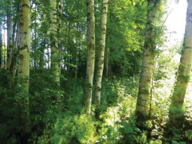
7 DOT&PF Jurisdictional Determination Report, KGB Road Reconstruction Project Table 1 Summary of Wetland Determination Field Plots. Data Plot Plot Type Wetland Determination Hydrophytic Vegetation Hydric Soils Wetland Hydrology NWI Code 101 Data Form Upland N N N U 102 Photo Point Upland N N N U 103 Photo Point Upland/Fill N N N U 104 Photo Point Upland N N N U 105 Data Form Upland N N N U 106 Photo Point Upland/Fill N N Y U 107 Data Form Upland Y N Y U 108 Data Form Wetland Y Y Y PSS1/EM1C 109 Data Form Wetland Y Y Y PEM1C 110 Data Form Wetland Y Y Y PSS4/1B 111 Photo Point Wetland Y Y Y PEM1/2C 112 Photo Point Upland/Fill N N N U 113 Photo Point Upland/Fill Y N/A (water body) Key: Y = Yes, N= No, N/A = Not applicable 3.1 Vegetation Y PEM1/UBx The corridor was dominated by upland mixed forest and development. One wetland complex containing several hydrophytic vegetation communities was observed just west of Lakewood Drive. The majority of this wetland contained open black spruce scrub. An open alder low shrub community was observed near the eastern edge of the wetland and sedge dominated meadows were intermixed in small openings. The vegetation within the wetland showed moderate disturbance. Standing dead paper birch (Betula paperifera) and black spruce (Picea mariana) trees were common and a pipeline/power line corridor was present near the wetland s eastern boundary. Inset 1. Typical open black spruce scrub community. Of the six plots where wetland determination data forms were completed, four had hydrophytic vegetation (Table 1). Brief descriptions of each hydrophytic community type are provided below, followed by a general description of the surrounding upland vegetation. 4
8 DOT&PF Jurisdictional Determination Report, KGB Road Reconstruction Project The most common hydrophytic community was open black spruce scrub (Inset 1); represented by field plot 110. Common plants included black spruce, (Picea mariana) dwarf birch (Betula glandulosa), Labrador tea (Ledum groenlandicum), leatherleaf (Chamaedaphne calyculata), cloudberry (Rubus chamaemorus) and russet s cotton-grass (Eriophorum russeolum). Standing dead black spruce trees were common throughout this community; their cover value was estimated at 20% within the data plot and they were common in surrounding areas as well. Open black spruce scrub is identified on the attached field forms (Appendix A) and map (Figure 2) by the NWI code PSS4/1B (palustrine, mixed needle leaved evergreen and broad leaved deciduous scrub-shrub, saturated wetland). An open low alder shrub community was the second most abundant hydrophytic vegetation type observed (Inset 2). Common plants included Sitka alder (Alnus sinuata), paper birch saplings, blue-joint reedgrass (Calamagrostis canadensis), and marsh cinquefoil (Potentilla palustris). This community contained an abundance of standing dead paper birch trees, with no live trees present. This community was documented by field plot 108 and coded on the attached map as a PSS1/EM1C wetland (palustrine, mixed scrub-shrub and persistent emergent, seasonally flooded wetland). Sedge meadow communities were dispersed throughout the wetland (Inset 3). Common plants included leatherleaf, russet s cotton-grass, hoary sedge (Carex canescens), and boreal bog sedge (Carex magellanica). Disturbance from a pipeline/powerline corridor forms the east and west boundaries of the largest sedge meadow within the wetland. Sedge meadows were documented by one wetland determination field plot (109) and one photo point (111). The species composition of both plots was similar with one general difference: water horsetail (Equisetum fluviatile) was more abundant at plot 111. The plots were coded PEM1C and PEM1/2C, 5 Inset 2. Typical open alder low shrub community with emergent vegetation in the foreground. Inset 3. Typical sedge meadow community. respectively (palustrine, persistent emergent, seasonally flooded wetland; and palustrine, mixed persistent/non-persistent emergent, seasonally flooded wetland). Two non-hydrophytic communities were documented with data plots in the project corridor: mixed paper birch and white spruce forest, and closed willow tall shrub. Both types were prevalent through the corridor and are represented by wetland determination plots 101, 105, and 107. Common plants
, woodland horsetail (Equisetum silvaticum), field horsetail (Equisetum arvense), oak fern (Gymnocarpium dryopteris), blue-joint reedgrass, and fireweed (Epilobium")
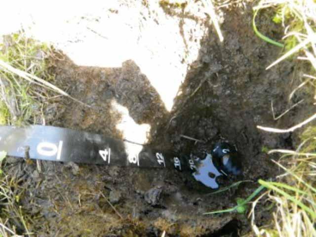
9 DOT&PF Jurisdictional Determination Report, KGB Road Reconstruction Project included paper birch, white spruce (Picea glauca), bebb willow (Salix bebbiana), high-bush cranberry (Viburnum edule), prickly rose (Rosa acicularis), woodland horsetail (Equisetum silvaticum), field horsetail (Equisetum arvense), oak fern (Gymnocarpium dryopteris), blue-joint reedgrass, and fireweed (Epilobium angustifolium). These non-hydrophytic communities were determined to be uplands, and were given the NWI code U. Developed, partially vegetated, and unvegetated sites were documented at photo points 103, 104, 106, and 112. When vegetation was present (not cleared), it was non-hydrophytic and included a mix of cottonwood saplings (Populus balsamifera), Scouler willow (Salix scouleriana), blue-joint reedgrass, and common roadside weeds. The attached mapping includes these areas with surrounding uplands 3.2 Soils NRCS soils mapping was available for the area showing the locations of hydric and non-hydric soil map units. Non-hydric soils dominate the corridor and were represented by Knik Silt Loam, Kalambach Silt Loam, and Deception Silt Loam. Two hydric map soil map units occur in one area, in the same approximate areas as the wetland described above. The hydric soil map units are Cryaquepts, depressional, 0 to 7 percent slopes; and Histosols (NRCS 2011). As suggested by the NRCS mapping, hydric soils were not found to be widespread during the field work. Five data plots had hydric soils and these were located within the same wetland complex (plots ). A typical hydric soil profile included an inch thick organic horizon with 4-10 inches of fibric material followed by 2-14 inches of hemic material (Inset 4). Mineral soil, a silt loam, was observed below the organic layers. Seasonal frost was also observed, between inches below the ground surface. Hydric soil indicators included the presence of Histic Epipedon (A2) and Histosol (A1) conditions. The histic epipedon at plot 108 was only 8 inches deep, the minimum required for this indicator. The underlying silt loam was tested for reducing conditions with alphaalpha dipyridyl; a positive reaction was observed, providing additional support for a hydric soil parameter at this data plot. Non-hydric soils were widespread throughout the remainder of the project corridor and are represented by 8 of the 13 data plots. 6 Inset 4. Typical hydric soil with thick organic horizon. Inset 5. Test pit of a moderately well drained non-hydric soil.
10 DOT&PF Jurisdictional Determination Report, KGB Road Reconstruction Project Two typical non-hydric soil profiles were observed. Well drained sites showed evidence of spodic soil development and included a thin organic surface horizon, followed by A, E, Bhs, Bs, and Bw layers. Moderately well drained soils contained a thin organic layer, followed by Bw layers (Inset 5). Soil textures for both types were silt loam and dominant hues matched the 10YR page from the Munsell Soil Color Chart (Munsell 2009). Photographs showing soil conditions for each sampled site are included in Appendix A. 3.3 Hydrology Precipitation data for the three-month period prior to the field investigation was reviewed to determine the degree to which any recent climatic events (i.e., abnormal wet or dry conditions) may have influenced field hydrology. The nearest available climate data was available from Anchorage ( Precipitation trends from Anchorage were assumed to be similar to the project area. The average precipitation totals over the three month period preceding the field visit were compared to normal totals from 1961 to 1990, using the NRCS Engineering Field Handbook method (NRCS 1997). This method weights the data by both the amount of precipitation and the relative age of a rainfall event. The values used for this comparison are shown in Table 2. Table 2 Long Term Precipitation Analysis Month 3 yrs in 10 less than 3 yrs in 10 more than Rain fall (actual) Condition Condition value Month Weight Value Sum Product (Condition x Weight) July Wet June Normal May Dry Sum 14 Conclusion: Antecedent precipitation was normal Using the NRCS method, it was determined that precipitation for the three months prior to the fieldwork was normal (Sum equals 14, where a value of is normal). Conditions observed in the field data correlate with this analysis; hydrology observations were well supported by landscape position, hydrophytic vegetation, and hydric soils. Evidence of wetland hydrology was observed at four plots where wetland determination forms were completed and at three additional photo points. The most common primary indicators were High Water Table (A2), Saturation (A3) and Dry-Season Water Table (C2). The most common secondary indicators were Stunted or Stressed Plants (D1), Geomorphic Position (D2) and FAC Neutral Test (D5). 7
11 DOT&PF Jurisdictional Determination Report, KGB Road Reconstruction Project One photo point, plot 106, had positive wetland hydrology from surface inundation but lacked positive vegetation or soil parameters. Several inches of water were perched on top of a compacted gravel parking lot. This area was determined to be an upland site. Wetland determination plot 107 had wetland hydrology from two secondary indicators (Oxidized rhizospheres on living roots, C3, and D2) and hydrophytic vegetation, but it and lacked hydric soils. This plot was located on a toeslope above the wetland complex and was determined to be an upland site, although influenced by transitional hydrology. Six data plots lacked wetland hydrology indicators. These plots were located throughout the corridor in flat or convex areas that were photo-interpreted to have potential wetland hydrology based on the Google Earth Imagery. During the field work, these sites were found to be well drained; often lacking any hydrophytic plants or hydric soil indicators. The surface inundation seen in the Google Earth Imagery was likely due to snowmelt temporarily perched above frozen ground. 4 Mapping Results Figure 2 and Figure 3 provide wetland/upland boundaries within the project area. The figures also show where wetland determination data forms and photo points were completed. Table 3 summarizes the acreage of wetlands and uplands within the project area by NWI classification. The project corridor encompasses approximately 604 acres with over 98% of the area mapped as uplands. Potentially jurisdictional wetlands comprise approximately 8 acres of scrub-shrub and emergent types. No water bodies or streams were identified on the project corridor. The wetland mapping from the MSB (Gracz 2011) coded this wetland as forested depression with shrubby areas. This is different from HDR s findings; trees were present but the abundance of live trees was too low to classify the wetland types as forested (standing dead trees were not included in the NWI classification criteria). Available NWI mapping was similar to HDR s although it classified the wetland as one NWI type, PSS1/4B. Site specific data collected for the project supports classifying the wetland as three different NWI types. Also, the wetland s eastern boundary extends further in this report than on the NWI mapping. 8
12 DOT&PF Jurisdictional Determination Report, KGB Road Reconstruction Project Table 3 Mapping Summary Mapping Codes Description Acres PSS4/1B PSS1/EM1C PEM1C PEM1/2C Saturated freshwater wetland with needle leaved evergreen scrub and broad leaved deciduous shrubs 5.06 Seasonally flooded freshwater wetland with broad leaved deciduous shrubs and persistent emergent vegetation 1.28 Seasonally flooded freshwater emergent wetland with persistent emergent vegetation 1.00 Seasonally flooded freshwater emergent wetland with persistent and non- persistent vegetation 0.72 Total Wetland Area 8.06 U Upland PEM1/UBx Stormwater run-off pond draining uplands (recommend nonjurisdictional) 0.36 Total Mapped Area Jurisdictional Status The wetland area described within this report appears to be connected by subsurface hydrology to adjacent wetlands to the north and Cottonwood Creek, which is located less than 1,000 feet to the south. Cottonwood Creek is a tributary to Knik Arm, a navigable water (USACE 1995); because the wetland extends beyond the project corridor, scientists did not walk the entire wetland/upland border to look for surface water connections. However, due to the wetland s elevation above Cottonwood Creek, and probable groundwater connections, this wetland is assumed to be jurisdictional; subject to confirmation by the USACE. A storm water collection pond is located near the corner of KGB Road and the Palmer-Wasilla Highway. It is shown on Figure 3 with the NWI code PEM1/UBx. The pond drains uplands, not wetlands, and by USACE definition, would be non-jurisdictional. 9
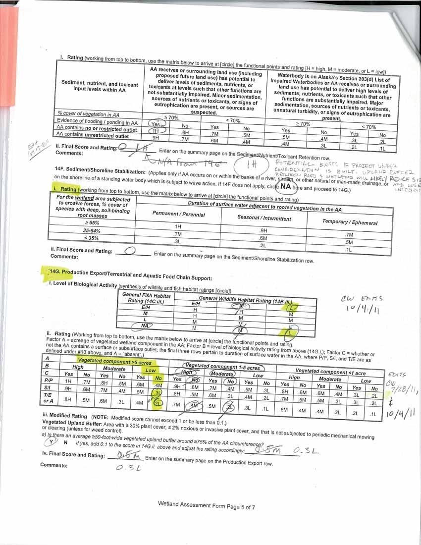
13 DOT&PF Jurisdictional Determination Report, KGB Road Reconstruction Project 6 Wetland Functional Assessment A functional assessment of the mapped wetland was performed using DOT&PF s Alaska Wetland Assessment Method (AKWAM). AKWAM assesses ten wetland functions and provides a quantitative method to evaluate their level of performance. Each function receives a rating from Low to High, and a score between 0 and 1, based on a combination of field observations and office based analysis. The scores, along with other indicators, are then used to rate the wetland in a Category from 1 to 4, where Category 1 wetlands rate the highest. Category ratings can be used to evaluate project alternatives and to determine compensatory mitigation ratios. The wetland identified in this report was evaluated as a single assessment area. The functional assessment data form is included in Appendix A. Table 4 summarizes the scores for each of the wetland functions and provides the Category rating for the wetland. This wetland was found to perform seven out of 10 functions. One function was rated high, two functions were rated moderate, four functions were rated low, and three functions were not performed. The highest rated function was Sediment/Nutrient/Toxicant Retention and Removal. In order to obtain a high rating for this function, a wetland must receive deleterious materials such as sediments, excess nutrients, or toxicants and it must also have the ability to retain and treat those contaminants. The wetland evaluated in this report met those requirements due to the following conditions. It is located near development; road runoff, pet waste, and dust are potential sources of contaminants; and it had the requisite vegetation density and hydrology to perform a relatively high amount of on-site treatment. The functions rated at a moderate level include: Water Storage and Groundwater Recharge. The functions rated at a low level include: Habitat for Federally Listed/Candidate T&E Species or Other Species of Concern, General Wildlife Support (due to the amount of surrounding development), Production Export/Food Chain Support, and Uniqueness. The following functions were not performed by this wetland and they did not receive a score. General Fish Support was not evident as there were no fish bearing water bodies within the assessment area, and therefore no fish habitat. Sediment/Shoreline Stabilization was performed as the assessment area does not occur on the banks of a water body and there was no flowing water observed in the wetland. Recreation/Education Potential was not applicable because there was no evidence that the wetland is currently, or planned for, these uses. In addition to above ratings, each function was assigned Actual Functional Points. The wetland received a score of 2.8 total Functional Points out of 7 Possible Functional Points. The Percent of the Possible Score (Functional Points divided by Possible Functional Points) was 40%. To determine the Category for the wetland, the percentage value is considered along with other criteria. For example, high ratings for Threatened or Endangered Species or Other Species of Concern, General 10
14 DOT&PF Jurisdictional Determination Report, KGB Road Reconstruction Project Fish Support, or Uniqueness can increase the Category for the wetland. This wetland did not meet any of the criteria and the Category ranking was determined based on the percentage value. The overall rating for the wetland is Category 3, a moderate to low functioning wetland. Category 3 wetlands have a Percent of Possible Score between 35 and 49% (this wetland scored 40%) and they do not meet any criteria of a Category 1 or 2 wetland. This wetland received a lower rating than Category 1 or 2 wetlands because of the absence of any streams or other water bodies, disturbance within the wetland, adjacent development, an abundance of similar wetlands within watershed, and moderate to low wildlife and habitat values. While the wetland performs important ecological functions within the Cottonweed Creek watershed, these factors limit the wetland from performing those functions at a higher level. Table 4 Summary of Wetland Assessment Ratings and Points Functions and Services Rating Actual Functional Points Possible Functional Points A. Habitat for Federally Listed/Candidate T&E Species or Other Species of Concern L B. General Wildlife Support L C. General Fish Support N/A N/A N/A D. Water Storage M E. Sediment/Nutrient/Toxicant Removal H F. Sediment/Shoreline Stabilization N/A N/A N/A G. Production Export/Food Chain Support L H. Groundwater Discharge/Recharge M I. Uniqueness L J. Recreation/Education Potential (bonus pts.) N/A N/A N/A Totals: Percentage of Possible Score: 40% Category* 3 Ratings: L=Low, M= Moderate, H=High *Category is reported on a scale of 1 to 4 where Category 1 wetlands have the highest value. 11
15 DOT&PF Jurisdictional Determination Report, KGB Road Reconstruction Project 7 References Cited Alaska Department of Transportation and Public Facilities Alaska Wetland Assessment Method (Version 1.0). Research and Technology Transfer Division and Statewide Environmental Office, Fairbanks and Juneau, Alaska. Cowardin, L. M., V. Carter, F. C. Golet, and E. T. LaRoe Classification of Wetlands and Deepwater Habitats of the United States. Office of Biological Services, U.S. Fish and Wildlife Service. Washington, DC. Google - Imagery DigitalGlobe, GeoEye Gracz, M Wetland Mapping and Classification of the Cook Inlet Lowlands, Alaska ( Accessed on July 15, Kodiak Mapping, Inc True color orthorectified aerial imagery. Acquired by DOT&PF. Munsell Color Munsell Soil-Color Charts. Grand Rapids, MI Natural Resources Conservation Service Hydrology Tools for Wetland Determination, Chapter 19, in Engineering Field Handbook, Part 650, 210-vi-EFH. USDA Natural Resources Conservation Service. Washington, DC. Natural Resource Conservation Service NRCS interactive Web Soil Survey. U.S. Army Corps of Engineers, Alaska District Special Public Notice (SPN) Corps of Engineers Regulatory Program, Consultant-Supplied Jurisdictional Determination Reports. Anchorage, AK. U.S. Army Corps of Engineers. U.S. Army Engineer Research and Development Center Regional Supplement to the Corps of Engineers Wetlands Delineation Manual: Alaska Region (Version 2.0). Washington, DC. U.S. Army Corps of Engineers Environmental Laboratory Corps of Engineers: Alaska District List of Navigable Waters (in addition to all Tidal Waters). Available online at: U.S. Army Corps of Engineers, Environmental Laboratory Corps of Engineers Wetlands Delineation Manual. Washington, DC. 12
16 DOT&PF Jurisdictional Determination Report, KGB Road Reconstruction Project U.S. Federal Register. November 13, 1986 Part II. Rules and Regulations, Vol. 51, No U.S. Department of Defense. Corps of Engineers, Department of the Army. 33 CFR Parts , Regulatory Programs of the Corps of Engineers; Final Rule. 13

17 113 (! Potentially Non-Jurisdictional Stormwater Retention Pond 112 (! Wetland Area ( ! _ ^ _ ^^ ^ (! 105 _ ^ 104 (! (! ^!( _ Figure 1: Overview Knik-Goose Bay Road Reconstruction Alaska Department of Transportation and Public Facilities Jurisdictional Determination Report Legend GPS Data Collection Points Fairbanks Anchorage _ ^ Project Area (! Data Form Site Photo Point Project Area Streams 0 5 Miles 3
18
19 PSS4/1B PEM1/2C PSS4/1B _ ^ PEM1C 110 _ ^ _ 109 ^ 108 PSS1/EM1C _ ^ 107 PEM1/2C PEM1/2C (! 111 U n wo o Co tto GPS Data Collection Points _ ^ (! Data Form Site Photo Point Project Area Wetland/Upland or Wetland Type Boundary Streams k Figure 2: Wetland Delineation Knik-Goose Bay Road Reconstruction Alaska Department of Transportation and Public Facilities Jurisdictional Determination Report Legend Wetlands within Project Corridor e d Cre 0 5 Feet 300
20

21 U (! 113 PEM1/UBX Figure 3: Stormwater Retention Pond Knik-Goose Bay Road Reconstruction Alaska Department of Transportation and Public Facilities Jurisdictional Determination Report Legend Potentially Non-Jurisdictional Stormwater Retention Pond GPS Data Collection Points _ ^ (! Data Form Site Photo Point Project Area Wetland/Upland or Wetland Type Boundary Streams 0 5 Feet 300
22
23 Appendix A Field Collected Data Jurisdictional Determination Forms and Site Photographs
24
25


26 Site 101. KGB Road Wetland Delineation Photo taken July 21, 2011 Site 101. KGB Road Wetland Delineation Photo taken July 21, 2011

27 Site 101. KGB Road Wetland Delineation Photo taken July 21, 2011
28
29


30 Site 105. KGB Road Wetland Delineation Photo taken July 21, 2011 Site 105. KGB Road Wetland Delineation Photo taken July 21, 2011

31 Site 105. KGB Road Wetland Delineation Photo taken July 21, 2011
32
33

34 Site 107. KGB Road Wetland Delineation Photo taken July 21, 2011 Site 107. KGB Road Wetland Delineation Photo taken July 21, 2011


35 Site 107. KGB Road Wetland Delineation Photo taken July 21, 2011 Site 107. KGB Road Wetland Delineation Photo taken July 21, 2011

36 Site 107. KGB Road Wetland Delineation Photo taken July 21, 2011
37
38


39 Site 108. KGB Road Wetland Delineation Photo taken July 21, 2011 Site 108. KGB Road Wetland Delineation Photo taken July 21, 2011


40 Site 108. KGB Road Wetland Delineation Photo taken July 21, 2011 Site 108. KGB Road Wetland Delineation Photo taken July 21, 2011
41
42


43 Site 109. KGB Road Wetland Delineation Photo taken July 21, 2011 Site 109. KGB Road Wetland Delineation Photo taken July 21, 2011


44 Site 109. KGB Road Wetland Delineation Photo taken July 21, 2011 Site 109. KGB Road Wetland Delineation Photo taken July 21, 2011


45 Site 109. KGB Road Wetland Delineation Photo taken July 21, 2011 Site 109. KGB Road Wetland Delineation Photo taken July 21, 2011
46
47


48 Site 110. KGB Road Wetland Delineation Photo taken July 21, 2011 Site 110. KGB Road Wetland Delineation Photo taken July 21, 2011


49 Site 110. KGB Road Wetland Delineation Photo taken July 21, 2011 Site 110. KGB Road Wetland Delineation Photo taken July 21, 2011
50
51
52
53
54
55
56
57 Field Collected Data Photo Points


58 Site 102. KGB Road Wetland Delineation Photo taken July 21, 2011 Site 102. KGB Road Wetland Delineation Photo taken July 21, 2011

59 Site 102. KGB Road Wetland Delineation Photo taken July 21, 2011


60 Site 103. KGB Road Wetland Delineation Photo taken July 21, 2011 Site 103. KGB Road Wetland Delineation Photo taken July 21, 2011

61 Site 103. KGB Road Wetland Delineation Photo taken July 21, 2011


62 Site 104. KGB Road Wetland Delineation Photo taken July 21, 2011 Site 104. KGB Road Wetland Delineation Photo taken July 21, 2011


63 Site 106. KGB Road Wetland Delineation Photo taken July 21, 2011 Site 106. KGB Road Wetland Delineation Photo taken July 21, 2011


64 Site 111. KGB Road Wetland Delineation Photo taken July 21, 2011 Site 111. KGB Road Wetland Delineation Photo taken July 21, 2011


65 Site 111. KGB Road Wetland Delineation Photo taken July 21, 2011 Site 111. KGB Road Wetland Delineation Photo taken July 21, 2011

66 Site 111. KGB Road Wetland Delineation Photo taken July 21, 2011


67 Site 112. KGB Road Wetland Delineation Photo taken July 21, 2011 Site 112. KGB Road Wetland Delineation Photo taken July 21, 2011


68 Site 113. KGB Road Wetland Delineation Photo taken July 21, 2011 Site 113. KGB Road Wetland Delineation Photo taken July 21, 2011
39. WETLANDS Introduction. Wetlands and Waterbodies Cook Inlet Drainages
 39. WETLANDS 39.1 Introduction This chapter summarizes the wetlands and waterbodies study for the Cook Inlet drainages study area (Figure 39-1). The objectives of the study were to determine and map the
Appendix E Preliminary Jurisdictional Wetland Delineation Report, JYL 2008
 Appendix E Preliminary Jurisdictional Wetland Delineation Report, JYL 2008 PRELIMINARY JURISDICTIONAL WETLAND DELINEATION REPORT A portion of USS 3819 and 2664: Horton Lot and Statter Harbor Juneau, Alaska
Appendix A. Wetland Determination Forms and Site Photography
 Appendix A Wetland Determination Forms and Site Photography DATA FORM ROUTINE WETLAND DETERMINATION (1987 COE Wetlands Delineation Manual) Project/Site: Sterling Highway Project MP 45-60 Date 8/11/03 Applicant
5.15 Wetlands and Other Waters of the U.S.
 I-70 East Final EIS 5.15 Wetlands and Other Waters of the U.S. 5.15 Wetlands and Other Waters of the U.S. This section discusses wetlands, open waters, and other waters of the U.S. in the study area and
Appendix C-3. Wetlands and Other Surface Waters Report
 Appendix C-3 Wetlands and Other Surface Waters Report WETLANDS AND OTHER SURFACE WATERS REPORT Hatchet Ridge Wind Energy Project Shasta County, California Prepared for: Hatchet Ridge Wind, LLC Portland,
38. VEGETATION Introduction. Vegetation Cook Inlet Drainages
 38. VEGETATION 38.1 Introduction The vegetation study describes the predominant vegetation types found in the Cook Inlet drainages study area. This information also helps to support wetland and habitat
Background. Literature Review
 Ms. Joanna Helms Economic Development Director Town of Apex 73 Hunter Street P.O. Box 250 Apex, North Carolina 27502 October 23, 2015 Reference: Report of Wetland Determination Cash Perkins Site ECS Project
Town of Fremont Wetland Evaluation Report
 University of New Hampshire University of New Hampshire Scholars' Repository PREP Reports & Publications Institute for the Study of Earth, Oceans, and Space (EOS) 9-2007 Town of Fremont Wetland Evaluation
Wetland Delineation for the 53 rd Street Overpass Project Corvallis, Oregon
 Wetland Delineation for the 53 rd Street Overpass Project (Township 12 South, Range 5 West, Section 4 West end of Tax Lot 120 & north side of Union Pacific right-of-way) Prepared for Benton County Public
Prepared by: Rummel, Klepper & Kahl
 WETLAND DELINEATION REPORT Kutztown Road (SR 1033) Resurfacing and Bridge Replacement Upper Hanover Township, Montgomery County, Pennsylvania Prepared for: PennDOT District 6-0 Prepared by: Rummel, Klepper
WETLAND DELINEATION REPORT
 WETLAND DELINEATION REPORT WHITMORE LAKE LOT WASHTENAW COUNTY, MICHIGAN JULY 2015 PREPARED FOR: WASHTENAW COUNTY PARKS AND RECREATION 2230 SOUTH PLATT ROAD ANN ARBOR, MICHIGAN 48104 PREPARED BY: THE MANNIK
Town of Sandown Wetland Evaluation Report
 Town of Sandown Wetland Evaluation Report Prepared for: Town of Sandown, NH Conservation Commission August 2008 Prepared by: 122 Mast Road, Suite 6, Lee, NH 03861 with assistance from TABLE OF CONTENTS
Wetland Delineation. Richard L. Darden, Ph.D. U.S. Army Corps of Engineers Charleston District October 3, 2012 BUILDING STRONG
 Wetland Delineation Richard L. Darden, Ph.D. U.S. Army Corps of Engineers Charleston District October 3, 2012 Why Delineate Wetlands? To define the limits of federal jurisdiction, in accordance with current
Wetland Identification/Delineation and Bog Turtle Habitat Screening Report for. S.R. 0097, Section 003 Two Taverns Bridge Replacement over Littles Run
 Wetland Identification/Delineation and Bog Turtle Habitat Screening Report for S.R. 0097, Section 003 Two Taverns Bridge Replacement over Littles Run June 2003 Prepared for: The Pennsylvania Department
SECONDARY WETLAND IMPACTS ANALYSIS
 SECONDARY WETLAND IMPACTS ANALYSIS USACE File. SWG-2012-00153 During the development of the Grand Parkway (State Highway 99) Segments H and I-1 from United States Highway 59/Interstate Highway 69 N to
Performance Standards for Target Hydrology
 Performance Standards for Target Hydrology Steve Eggers Senior Ecologist Regulatory Branch St. Paul District December 10, 2015 US Army Corps of Engineers Introduction Target Hydrology: the hydrology necessary
Attachment C Applicant s Proposed Mitigation Statement Alaska DOT&PF Northern Region Pilot Station Airport Relocation Project POA
 Attachment C Applicant s Proposed Mitigation Statement Alaska DOT&PF Northern Region Pilot Station Airport Relocation Project POA-2004-1223 Introduction This mitigation statement was prepared as an attachment
CHAPTER 7 PHYSICAL INVENTORY OF THE CITY
 CHAPTER 7 PHYSICAL INVENTORY OF THE CITY Chapter 7: Physical Inventory of the City 39 This page intentionally left blank. Chapter 7: Physical Inventory of the City 40 SECTION 1 PHYSICAL SETTING While communities
A GUIDE TO THE WETLAND, DEEPWATER HABITATS, AND RIPARIAN CLASSIFICATIONS USED IN WETLAND AND RIPARIAN MAPPING IN MONTANA
 A GUIDE TO THE WETLAND, DEEPWATER HABITATS, AND RIPARIAN CLASSIFICATIONS USED IN WETLAND AND RIPARIAN MAPPING IN MONTANA Purpose: The Montana Natural Heritage Program s Wetland and Riparian Mapping Center
Plant, Wildlife and Wetland Assessment
 WSU Project Site Plant, Wildlife and Wetland Assessment approximately 38 acres of the site would be in retained natural area, including passive use portions of the park and smaller natural areas in other
Public Input Meeting. Proposed Central New York Wetland Mitigation Bank. March 20, 2017
 Public Input Meeting Proposed Central New York Wetland Mitigation Bank March 20, 2017 What in the world is wetlands mitigation? What is a wetland? Hydrology (surface water or groundwater) Hydric soil Hydrophytes
Department of the Army Permit Application
 Department of the Army Permit Application DA File Number U.S. Army Corps of Engineers Honolulu District Date Received by CEPOH-RO Send Completed Application to: Honolulu District, U.S. Army Corps of Engineers
WETLAND IDENTIFICATION AND DELINEATION REPORT. Milford Township Somerset County, Pennsylvania. Prepared By:
 State Route 653, Section 07B Bridge Replacement Over South Glade Creek WETLAND IDENTIFICATION AND DELINEATION REPORT Milford Township Somerset County, Pennsylvania Prepared By: PENNDOT Engineering District
SITE ANALYSIS. 1. Hydrophytic Vegetation: A predominance of plants that are typically adapted for life in saturated soils.
 Soil Mapping The soil mapping inventory completed by the Natural Resource Conservation Service was reviewed as a part of this assessment (fig. 4). This mapping identified the soils generally throughout
S.R. 430, Segment 250 Offset 0000, Greenfield Township Wetland Delineation
 S.R. 430, Segment 250 Offset 0000, Greenfield Township Wetland Delineation Date: October 30, 2007 Re: To: From: Erie County SR 430 Segment 250 Offset 0000 Wetland Delineation Mr. Todd Palmer Bridge Unit
Municipal Stormwater Management Plan Prepared For The Borough of Cape May Point By Van Note-Harvey Associates VNH File No.
 Municipal Stormwater Management Plan Prepared For The Borough of Cape May Point By Van Note-Harvey Associates 2005 VNH File No. 35317-210-21 Table of Contents Introduction... 3 Goals... 3 Storm water Discussion...
Routine Wetland Determination
 Project/Site: 60-0008-0560-0032 Applicant/owner: PENNDOT, Eng. District 1-0 Investigator(s): Christopher R. Wolfgong Routine Wetland Determination DATA FORM 1 (Revised) 1987 Corps Wetland Delineation Manual)
Guidelines for Conducting and Reporting Hydrologic Assessments of Potential Wetland Sites
 Wetlands Regulatory Assistance Program ERDC TN-WRAP-00-01 Guidelines for Conducting and Reporting Hydrologic Assessments of Potential Wetland Sites PURPOSE: This technical note provides guidance on performing
What is a Wetland? Common Wetland Names. Wetlands: Ecotones between Upland and Aquatic Systems. Matthew J. Gray University of Tennessee.
 What is a Wetland? Matthew J. Gray University of Tennessee Common Wetland Names Backwater swamps Peatland Estuary Vernal Pools Marsh Playa Fen Bog Bayou Spring Seep Humedales Wetlands: Ecotones between
WETLAND DETERMINATION DATA FORM Eastern Mountains and Piedmont
 WETLAND DETERMINATION DATA FORM Eastern Mountains and Piedmont Project/Site: PIK-104-10.62 (PID: 83667) City/County: Pike Sampling Date: 5.30.13 Applicant/Owner: ODOT State: OH Sampling Point: 36 Investigator(s):
Chapter 10 Natural Environment
 Chapter 10 Natural Environment Existing Conditions The Natural Environment Element addresses the protection, conservation, preservation, and restoration of the natural resources the Bayview Ridge Subarea,
Whitcomb Heights Subdivision Wetland Delineation Project No.: 90570
 Whitcomb Heights Subdivision Wetland Delineation Project No.: 90570 WETLAND DELINEATION REPORT Prepared for City and Borough of Sitka 100 Lincoln Street Sitka, Alaska 99835 July 2008 Prepared by USKH Inc.
APPENDIX B. If the GRANIT Data Mapper gets stuck during an operation, use the refresh button in your browser.
 APPENDIX B ANSWERING QUESTIONS THAT REQUIRE THE GRANIT DATA MAPPER ONLINE TOOLS AND PRINTED MAPS (Remaining questions are answered during field checking) Each of the questions in the table on the following
Big Chino Valley Pumped Storage Pject (FERC No ) Preliminary Jurisdictional Determination Study Plan
 Preliminary Jurisdictional Determination Study Plan") March 21, 2018 1.0 Introduction Big Chino Valley Pumped Storage LLC, a subsidiary of ITC Holdings Corp. (ITC), submitted a preliminary permit application to the Federal Energy Regulatory Commission (FERC
March 21, 2018 1.0 Introduction Big Chino Valley Pumped Storage LLC, a subsidiary of ITC Holdings Corp. (ITC), submitted a preliminary permit application to the Federal Energy Regulatory Commission (FERC
ORM Printer Friendly JD Form
 Page 1 of 5 APPROVED JURISDICTIONAL DETERMINATION FORM U.S. Army Corps of Engineers SECTION I: BACKGROUND INFORMATION A. REPORT COMPLETION DATE FOR APPROVED JURISDICTIONAL DETERMINATION (JD): 14-Jun-2012
DRAFT GREATER MOOSES TOOTH TWO (GMT2) DEVELOPMENT PROJECT PERMITTEE RESPONSIBLE WETLANDS MITIGATION PLAN NATIONAL PETROLEUM RESERVE-ALASKA
 DEVELOPMENT PROJECT PERMITTEE RESPONSIBLE WETLANDS MITIGATION PLAN NATIONAL PETROLEUM RESERVE-ALASKA") DRAFT GREATER MOOSES TOOTH TWO (GMT2) DEVELOPMENT PROJECT PERMITTEE RESPONSIBLE WETLANDS MITIGATION PLAN NATIONAL PETROLEUM RESERVE-ALASKA Prepared for: ConocoPhillips Alaska, Inc. Anchorage, AK March
DRAFT GREATER MOOSES TOOTH TWO (GMT2) DEVELOPMENT PROJECT PERMITTEE RESPONSIBLE WETLANDS MITIGATION PLAN NATIONAL PETROLEUM RESERVE-ALASKA Prepared for: ConocoPhillips Alaska, Inc. Anchorage, AK March
PORT OF VANCOUVER, USA PARCEL 1A NE LAYDOWN CRITICAL AREAS REPORT
 PORT OF VANCOUVER, USA PARCEL 1A NE LAYDOWN CRITICAL AREAS REPORT February 2012 Prepared by: Port of Vancouver, USA 3103 NW Lower River Road Vancouver, Washington 98660 360.693.3611 CONTENTS 1 Introduction...
Resource Protection Areas: Nontidal Wetlands Guidance on the Chesapeake Bay Preservation Area Designation and Management Regulations June 18, 2007
 Resource Protection Areas: Nontidal Wetlands Guidance on the Chesapeake Bay Preservation Area Designation and Management Regulations June 18, 2007 Purpose: This document provides guidance on requirements
 Page 1 of 5 APPROVED JURISDICTIONAL DETERMINATION FORM U.S. Army Corps of Engineers SECTION I: BACKGROUND INFORMATION A. REPORT COMPLETION DATE FOR APPROVED JURISDICTIONAL DETERMINATION (JD): 02-Nov-2012
February 26, Mr. Mark Allen Allen Engineering, LLC 2 Willowbrook Lane Mendon MA, Sent Via
 February 26, 2018 Mr. Mark Allen Allen Engineering, LLC 2 Willowbrook Lane Mendon MA, 01756 Sent Via Email: allenengineering@comcast.net RE: Wetland Review Macy Estates Off of Monique Drive Plat 29 Lot
PORT OF VANCOUVER, USA PARCEL 1A NE LAYDOWN WETLAND DELINEATION
 PORT OF VANCOUVER, USA PARCEL 1A NE LAYDOWN WETLAND DELINEATION February 2012 Prepared by: Port of Vancouver, USA 3103 NW Lower River Road Vancouver, Washington 98660 360.693.3611 TABLE OF CONTENTS INTRODUCTION...
Wetlands Mapping in the Vicinity of the Mineral King Valley Cabins and Corral, Sequoia and Kings Canyon National Parks
 Wetlands Mapping in the Vicinity of the Mineral King Valley Cabins and Corral, Sequoia and Kings Canyon National Parks Joel Wagner, NPS Water Resources Division, National Park Service, PO Box 25287, Denver,
MN CREP CP23 and CP23A
 MN CREP CP23 and CP23A Environmental Benefits Scoring Sheet Instructions 4/14/17 Scoring is a primary means of comparing the environmental benefits of each submitted application for MN CREP. To properly
Snitz Creek Park Wetland Mitigation Bank Prospectus. Pennsylvania Department of Transportation Engineering District 8-0
 Snitz Creek Park Wetland Mitigation Bank Prospectus Pennsylvania Department of Transportation Engineering District 8-0 February 2010 In accordance with 33 CFR 332.8(d)(2), The Pennsylvania Department of
' MY () Interim Risk Reduction Measures Grubbing in Cleared Areas Chena River Lakes Project Fairbanks, Alaska
 Interim Risk Reduction Measures Grubbing in Cleared Areas Chena River Lakes Project Fairbanks, Alaska") Alaska District U.S. Army Corps of Engineers Civil Works Branch Public Notice ' MY () 4 2010 Date Identification No. ER-10-04 Please refer to the identification number when replying. Interim Risk Reduction
Alaska District U.S. Army Corps of Engineers Civil Works Branch Public Notice ' MY () 4 2010 Date Identification No. ER-10-04 Please refer to the identification number when replying. Interim Risk Reduction
Wetland Determination/Delineation Whaley-Sharp Property Tippecanoe County, Lafayette, Indiana Patriot Project No E
 Wetland Determination/Delineation Whaley-Sharp Property Tippecanoe County, Lafayette, Indiana Patriot Project. 7-0390-0E Prepared For Mr. Rich Whaley Nationwide Insurance 306 New Britton Drive Fishers,
CONCEPTUAL COMPENSATORY MITIGATION PLAN for wetland losses
 CONCEPTUAL COMPENSATORY MITIGATION PLAN for wetland losses Teton County Idaho Reconstruction of W6000S, from Chapin Lane to W5750S May 21, 2015 Prepared for: Teton County Idaho Darryl Johnson, Public Works
I THOUGHT IT WAS JUST WET LAND: A GUIDE TO ENVIRONMENTAL PERMITTING FOR AIRPORTS ROAD SCHOOL 2018 SIMON DAVIES, SENIOR SCIENTIST MARCH 7, 2018
 I THOUGHT IT WAS JUST WET LAND: A GUIDE TO ENVIRONMENTAL PERMITTING FOR AIRPORTS ROAD SCHOOL 2018 SIMON DAVIES, SENIOR SCIENTIST MARCH 7, 2018 Definition Regulatory Definition - Those areas that are inundated
Each point here will be imaged with airborne LiDAR and visited by crews to measure trees and their condition.
 2014 Interior Alaska Highlights: Forests of the Tanana Valley State Forest and Tetlin National Wildlife Refuge Alaska This briefing is a synopsis of a more detailed report that is being published by the
SECTION I: BACKGROUND INFORMATION
 APPROVED JURISDICTIONAL DETERMINATION FORM U.S. Army Corps of Engineers SECTION I: BACKGROUND INFORMATION A. REPORT COMPLETION DATE FOR APPROVED JURISDICTIONAL DETERMINATION (JD): 03-Dec-2012 B. DISTRICT
Surface Water and Non-Wetland Surface Waters Delineation and Classification pursuant Chapter F.A.C.
 Surface Water and Non-Wetland Surface Waters Delineation and Classification pursuant Chapter 62-340 F.A.C. What are Waters? 373.019 F.S. Definitions (20) Water or waters in the state means any and all
2015 Reinvest in Minnesota (RIM) Reserve Wetlands Program
 Reserve Wetlands Program") 2015 Reinvest in Minnesota (RIM) Reserve Wetlands Program Site Evaluation Form Instructions Document 12/31/14 This instructions document is to be used for guidance in completing the Site Evaluation Form
2015 Reinvest in Minnesota (RIM) Reserve Wetlands Program Site Evaluation Form Instructions Document 12/31/14 This instructions document is to be used for guidance in completing the Site Evaluation Form
Instructions for Notice of Ground Disturbance Form:
 Instructions for Notice of Ground Disturbance Form: Prior to beginning any ground disturbance activity or finalizing your storm water plan, submit a completed 2 page Notice of Ground Disturbance Form to
APPENDIX J: Wetlands Technical Report
 APPENDIX J: Wetlands Technical Report J.1 Existing Conditions The Department of Environmental Protection (PADEP) and the US Army Corps of Engineers jointly regulate wetland activities in the state. The
Deep River-Portage Burns Waterway Watershed 2015
 2.4 Soils Soil development is the product of the interaction of parent material, topography, climate, organisms and time. Understanding the types of soils that exist within a watershed and their characteristics
APPROVED JURISDICTIONAL DETERMINATION FORM U.S. Army Corps of Engineers
 APPROVED JURISDICTIONAL DETERMINATION FORM U.S. Army Corps of Engineers This form should be completed by following the instructions provided in Section IV of the JD Form Instructional Guidebook. SECTION
Wetland Functions in the Watershed: Part 1 Watershed Elements. USDA NRCS Module Name 1
 Wetland Functions in the Watershed: Part 1 Watershed Elements USDA NRCS Module Name 1 Objectives Define Landscape Elements in the Watershed Describe Hydrologic Connections Between Elements Introduce Soil
Municipal Stadium Wetland
 W A T E R S H E D F A C T S Total watershed area 140 mi 2 Average annual rainfall 38 in Average annual temperature 58 F Elevation Max 1321 ft Min 899 ft C. J. Brown Reservoir controls flow from 83 mi 2
Chapter 2: Conditions in the Spring Lake Watershed related to Stormwater Pollution
 Chapter 2: Conditions in the Spring Lake Watershed related to Stormwater Pollution To identify the primary causes and consequences of stormwater discharges to Spring Lake and its adjoining waterbodies,
Legal Perspectives on Florida Wetland Jurisdiction
 Legal Perspectives on Florida Wetland Jurisdiction Timothy J. Perry, Esq. Oertel, Fernandez, Bryant & Atkinson, P.A. Tallahassee, Florida tperry@ohfc.com History 1993 Florida Environmental Reorganization
Wetlands. DuPage County Stormwater Ordinance Update- Wetlands and Buffers. Is a Stormwater Permit Required? 7/13/2012
 DuPage County Stormwater Ordinance Update- Wetlands and Buffers PRESENTED BY: MARY BETH FALSEY WETLAND SPECIALIST Wetlands Section 15-18.A.1.a: If a Stormwater Administrator has the expertise, he/she can
Agricultural Ditches, Waterways and Wetlands: Sorting It Out
 Agricultural Ditches, Waterways and Wetlands: Sorting It Out Eric Metz Planning & Policy Manager Aquatic Resource Management 503-986-5266 eric.metz@state.or.us Clatsop SWCD Waterways Seminar March 16,
APPROVED JURISDICTIONAL DETERMINATION FORM U.S. Army Corps of Engineers
 APPROVED JURISDICTIONAL DETERMINATION FORM U.S. Army Corps of Engineers This form should be completed by following the instructions provided in Section IV of the JD Form Instructional Guidebook. SECTION
ABBREVIATED NOTICE OF RESOURCE AREA DELINEATION YANKEE NUCLEAR POWER STATION ROWE, MASSACHUSETTS MARCH 2004 PREPARED FOR
 ABBREVIATED NOTICE OF RESOURCE AREA DELINEATION YANKEE NUCLEAR POWER STATION ROWE, MASSACHUSETTS MARCH 2004 PREPARED FOR YANKEE ATOMIC ELECTRIC COMPANY 49 YANKEE ROAD ROWE, MASSACHUSETTS 01367 PREPARED
Regulatory Program. SECTION I: BACKGROUND INFORMATION A. COMPLETION DATE FOR APPROVED JURISDICTIONAL DETERMINATION (JD): March 04, 2019
: March 04, 2019") Regulatory Program APPROVED JURISDICTIONAL DETERMINATION FORM U.S. Army Corps of Engineers This form should be completed by following the instructions provided in the Approved Jurisdictional Determination
Regulatory Program APPROVED JURISDICTIONAL DETERMINATION FORM U.S. Army Corps of Engineers This form should be completed by following the instructions provided in the Approved Jurisdictional Determination
Public Notice ISSUED: 11 February 2019 EXPIRES: 13 March 2019
 SPONSOR: Minnesota Board of Water and Soil Resources Public Notice ISSUED: 11 February 2019 EXPIRES: 13 March 2019 REFER TO: MVP-2019-0122-JTB SECTION: 404 - Clean Water Act 1. WETLAND COMPENSATORY MITIGATION
APPROVED JURISDICTIONAL DETERMINATION FORM U.S. Army Corps of Engineers
 APPROVED JURISDICTIONAL DETERMINATION FORM U.S. Army Corps of Engineers SECTION I: BACKGROUND INFORMATION A. REPORT COMPLETION DATE FOR APPROVED JURISDICTIONAL DETERMINATION (JD): August 14, 2017 B. DISTRICT
Hydrophytic Vegetation Present? Yes No Hydric Soil Present? Yes No Wetland Hydrology Present? Yes No Remarks:
 Project/Site: North Branch Pigeon Creek Mitigation Bank City/County: Eighty Four/ Washington Sampling Date: 1/15/13 Applicant/Owner: First Pennsylvania Resource, LLC. State: PA Sampling Point: FDS-4 Investigator(s):
US ARMY CORPS Reply To: Public Notice No. OF ENGINEERS U.S. Army Corps of Engineers P-3121
 US ARMY CORPS Reply To: Public Notice No. OF ENGINEERS U.S. Army Corps of Engineers P-3121 St. Louis District Attn: CEMVS-OD-F Gateway to Excellence 1222 Spruce Street Public Notice Date: St. Louis, Missouri
7.6 Wetlands, Riparian and Littoral Habitats
 7.6 Wetlands, Riparian and Littoral Habitats 7.6.1 Overview Yuba County Water Agency This section discusses wetland, riparian and littoral habitats in the vicinity 1 of Yuba County Water Agency s (YCWA
SAN LORENZO VALLEY WATER DISTRICT CAMPUS CENTER PROJECT WETLAND MITIGATION AND MONITORING PLAN. San Lorenzo Valley Water District
 SAN LORENZO VALLEY WATER DISTRICT CAMPUS CENTER PROJECT WETLAND MITIGATION AND MONITORING PLAN Prepared For: San Lorenzo Valley Water District Prepared By: Denise Duffy & Associates, Inc. 947 Cass St.
Regulatory Program. SECTION I: BACKGROUND INFORMATION A. COMPLETION DATE FOR APPROVED JURISDICTIONAL DETERMINATION (JD): 16 September 2015
: 16 September 2015") Regulatory Program APPROVED JURISDICTIONAL DETERMINATION FORM U.S. Army Corps of Engineers This form should be completed by following the instructions provided in the Approved Jurisdictional Determination
Regulatory Program APPROVED JURISDICTIONAL DETERMINATION FORM U.S. Army Corps of Engineers This form should be completed by following the instructions provided in the Approved Jurisdictional Determination
Maintaining Riparian Areas and Wetlands
 Maintaining Riparian Areas and Wetlands Riparian areas are the lands along the banks of our rivers, lakes, and tidal waters. Many riparian areas not only border surface waters, but they are often adjacent
FEDERAL WETLANDS PERSPECTIVE DEPARTMENT OF THE ARMY REGULATORY PROGRAM
 FEDERAL WETLANDS PERSPECTIVE DEPARTMENT OF THE ARMY REGULATORY PROGRAM Andrew Commer Chief, Regulatory Office Tulsa District 8 April 2015 US Army Corps of Engineers Regulatory Statutory Authorities - RIVERS
INDIAN CREEK WATERSHED PLAN EXECUTIVE SUMMARY
 INDIAN CREEK WATERSHED PLAN EXECUTIVE SUMMARY The Indian Creek Watershed covers a 38 square mile area in southern Lake County, Illinois that drains 24,116 acres before discharging into the Des Plaines
SECTION 3 NATURAL RESOURCES
 SECTION 3 NATURAL RESOURCES The natural environment plays a large role in planning for future development. Environmental conditions, such as topography, wetlands, floodplains, and water bodies, can often
HOUSE BILL lr0052
 M HOUSE BILL lr00 By: Chair, Environment and Transportation Committee (By Request Departmental Environment) Introduced and read first time: February, 0 Assigned to: Environment and Transportation Committee
Mapping and Understanding YOUR LAKE S WATERSHED By: Tony Groves, Pam Tyning, and Tory Meyers Water Resources Group, Progressive AE
 By: Tony roves, Pam Tyning, and Tory Meyers Water Resources roup, Progressive A What is a Watershed? A watershed is the land area surrounding a lake from which water drains to the lake. The imaginary line
3 Baseline and Existing Conditions
 1 2 3 4 5 6 7 8 9 10 11 12 13 14 3 Baseline and Existing Conditions The effective date of the VSP legislation is July 22, 2011. This is also the date chosen by the legislature as the applicable baseline
Appendix D: MULTI-AGENCY COMPENSATORY MITIGATION PLAN CHECKLIST 1
 Appendix D: MULTI-AGENCY COMPENSATORY MITIGATION PLAN CHECKLIST 1 Mitigation Goals and Objectives o Describe functions lost at impact site o Describe functions to be gained at mitigation site o Describe
Regulatory Program. SECTION I: BACKGROUND INFORMATION A. COMPLETION DATE FOR APPROVED JURISDICTIONAL DETERMINATION (JD): 15-Oct-2018
: 15-Oct-2018") Regulatory Program APPROVED JURISDICTIONAL DETERMINATION FORM U.S. Army Corps of Engineers This form should be completed by following the instructions provided in the Approved Jurisdictional Determination
Regulatory Program APPROVED JURISDICTIONAL DETERMINATION FORM U.S. Army Corps of Engineers This form should be completed by following the instructions provided in the Approved Jurisdictional Determination
Regulatory Program SECTION I: BACKGROUND INFORMATION A. COMPLETION DATE FOR APPROVED JURISDICTIONAL DETERMINATION (JD): 11/26/2018
: 11/26/2018") Regulatory Program APPROVED JURISDICTIONAL DETERMINATION FORM U.S. Army Corps of Engineers This form should be completed by following the instructions provided in the Approved Jurisdictional Determination
Regulatory Program APPROVED JURISDICTIONAL DETERMINATION FORM U.S. Army Corps of Engineers This form should be completed by following the instructions provided in the Approved Jurisdictional Determination
Public Notice ISSUED: August 7, 2013 EXPIRES: September 6, 2013
 APPLICANT: City of Winona Public Works Department Public Notice ISSUED: August 7, 2013 EXPIRES: September 6, 2013 REFER TO: 2010-01944-DAS SECTION: 404 - Clean Water Act 10 Rivers and Harbors Act 1. APPLICATION
LANDFIRE Biophysical Setting Model
 Biophysical Setting: This BPS is lumped with: This BPS is split into multiple models: General Information Contributors Modeler 1 Joan Foote Modeler 2 Colleen Ryan Modeler 3 LANDFIRE Biophysical Setting
SECTION I: BACKGROUND INFORMATION
 APPROVED JURISDICTIONAL DETERMINATION FORM U.S. Army Corps of Engineers SECTION I: BACKGROUND INFORMATION A. REPORT COMPLETION DATE FOR APPROVED JURISDICTIONAL DETERMINATION (JD): 06-Jun-2008 B. DISTRICT
SECTION 10: WETLANDS PROTECTION
 SECTION 10: WETLANDS PROTECTION 10-1 INTENT AND PURPOSE A. Intent 1. The City finds that wetlands serve a variety of beneficial functions. Wetlands maintain water quality, reduce flooding and erosion,
USE ATTAINABILITY ANALYSIS Unnamed Drainage to Foster Reservoir in the Beaver Creek Watershed, Big Horn Basin. March 9, 2004
 USE ATTAINABILITY ANALYSIS Unnamed Drainage to Foster Reservoir in the Beaver Creek Watershed, Big Horn Basin March 9, 2004 Waterbody: Unnamed Drainage - Mainstem Entire Length and Foster Reservoir Location:
APPROVED JURISDICTIONAL DETERMINATION FORM U.S. Army Corps of Engineers
 APPROVED JURISDICTIONAL DETERMINATION FORM U.S. Army Corps of Engineers SECTION I: BACKGROUND INFORMATION A. REPORT COMPLETION DATE FOR APPROVED JURISDICTIONAL DETERMINATION (JD): May 7, 2015 B. DISTRICT
5.4 Alternative 2: Structural Flood Protection Without Flood Retention Facility
 5.4 Alternative 2: Structural Flood Protection Without Flood Retention Facility Structural Flood Protection Without Flood Retention Facility (Alternative 2) would reduce flood damage during a major flood
3D WETLAND MANAGEMENT
 3D WETLAND MANAGEMENT 1. ISSUE Wetlands are one of the most productive ecosystems. They provide biological and chemical functions to the landscape that serve the watershed including the moderation of nutrient
FIGURE 1 KUSKOKWIM RIVER MITIGATION BANK LOCATION MAP for BANK SITES LEVEL III ECOREGIONS, & 8-DIGIT HUCs
 19040803 Lower Innoko River Donlin Mine Alaska Project Location Interior Forested Lowlands and Uplands Source: Esri, DigitalGlobe, GeoEye, icubed, Earthstar Geographics, CNES/Airbus 19030501 Aniak Fuller
Waters of the U.S. and Wetlands
 Waters of the U.S. and Wetlands Jenny Blair, CWB Senior Environmental Scientist Overview Regulatory background What are Waters of the U.S.? What are Wetlands? What is regulated and how? What does all of
From My Backyard to Our Bay It s the 911 for the Chesapeake Bay
 From My Backyard to Our Bay Reporting Problems on Our Bay, Rivers, and Streams We can all be the eyes and ears of our local waterways. Maryland has established the Chesapeake Bay Safety and Environmental
Wetlands and Waters of the U.S. Technical Report. November 2008
 Wetlands and Waters of the U.S. Technical Report November 2008 I-70 East Draft Environmental Impact Statement Wetlands and Waters of the U.S. Technical Report Table of Contents 1.0 INTRODUCTION...1 2.0
Regulatory Program SECTION I: BACKGROUND INFORMATION A. COMPLETION DATE FOR APPROVED JURISDICTIONAL DETERMINATION (JD):
:") Regulatory Program APPROVED JURISDICTIONAL DETERMINATION FORM U.S. Army Corps of Engineers This form should be completed by following the instructions provided in the Approved Jurisdictional Determination
Regulatory Program APPROVED JURISDICTIONAL DETERMINATION FORM U.S. Army Corps of Engineers This form should be completed by following the instructions provided in the Approved Jurisdictional Determination
Legal Perspectives on Florida Wetland Jurisdiction
 Legal Perspectives on Florida Wetland Jurisdiction Timothy J. Perry, Esq. Oertel, Fernandez, Bryant & Atkinson, P.A. Tallahassee, Florida tperry@ohfc.com History 1993 Florida Environmental Reorganization
CRITICAL AREA DETERMINATION REPORT & HABITAT MANAGEMENT PLAN
 CRITICAL AREA DETERMINATION REPORT & HABITAT MANAGEMENT PLAN FOR SNOHOMISH COUNTY PUD NO. 1 MACHIAS CUTOFF WATER MAIN EXTENSION SNOHOMISH COUNTY, WA Project #12078 Prepared By 9505 19th Avenue SE, Suite
U.S. Army Corps of Engineers. Regulatory Branch Program Overview
 Regulatory Branch Program Overview REGULATORY BRANCH Special Projects Team Policy Issues Complex Permit Evaluations Mitigation Banks Surveillance and Enforcement Section Enforcement Jurisdictional Determinations
Appendix A Stormwater Site Plan Report Short Form
 Appendix A Stormwater Site Plan Report Short Form The Stormwater Site Plan Report Short Form may be used for projects that trigger only Minimum Requirements #1-#5. These projects typically fall within
Pennichuck Brook Watershed Buildout Analysis December 2003
 INTRODUCTION The Pennichuck Brook watershed (Figure 1) includes approximately 17,700 acres within the communities of Amherst, Hollis, Merrimack, Milford and Nashua and is the primary drinking water supply