Country proposal - SRI LANKA
|
|
|
- Shavonne Anderson
- 5 years ago
- Views:
Transcription
1 Country proposal - SRI LANKA P. M. Jayatilaka Banda Department of Meteorology, Nihal Rupasinghe Central Engineering Consultancy Bureau and S. B. Weerakoon University of Peradeniya, Sri Lanka Asia Water Cycle Symposium, 9-10 January 2007, Tokyo, Japan
 5000 4000 5000 3000 4000")
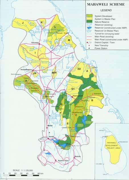
2 Water Resources in Sri Lanka Sri Lanka has 103 river basins with sizes varying from km 2. High spatial and temporal variation of rainfall Water resources issues - Floods Water scarcity Jaffna River basin boundary Rainfall gauging station Mean Annual Rainfall (mm) Trincomalee Batticaloa Colombo There are only 35 stream flow measuring stations Galle
3 Proposed basins and their issues Kaluganga basin (2720 sq km) Floods Mahaweli basin (10450 sq.km) Water management under multi-uses Nilwala basin Floods, Irrigation water management

4 Kaluganga Basin
 Elevation up to 2250 m River length 129 km Length to")
5 Kaluganga Basin Magnitude of the annual flow volume 4000 MCM Catchments area 2690 sq. km Average annual rainfall 4000 mm ( mm) Elevation up to 2250 m River length 129 km Length to Ratnapura 65 km Streams

6 Kaluganga Basin Back Source Irrigation Dept.


7 Catchments area Average annual rainfall Mahaweli Basin sq. km mm Streams Paddy
8

")
9 Mahaweli Basin (Kotmale Subbasin) 300sq km

10 Nilawala Ganga basins Nilwala basin (971 sq km) Floods Irrigation water management Mahaweli Kalu Nilwala

11 Nilwala Ganga Basin Back Source Irrigation Dept.
12 Data availability of proposed basins Reference basin Sri Lanka Mahaweli Basin Sri Lanka Kaluganga Basin Sri Lanka Nilwalaganga Basin METADATA (River Basin Description) Location (longitude and lattitude (06 o 45 l N, 80 o 40 l E to 08 o 30 l N, (06 o 25 l N, 80 o 00 l E to 06 o 50 l N, (06 o 00 l N, 80 o 25 l E to 06 o 30 l N, extent) 81 o 15 l E) 80 o 40 l E) 80 o 45 l E) Catchment outlet longitude and latitude 08deg30min N, 81deg15min E 06deg35min N, 80deg00min E 06deg00min N, 80deg30min E Catchment area sqkm 2719 sqkm 971 sqkm Number of MOLTS points in the basin MOLTS point1 longitude and latitude 07deg20min N, 80deg38min E 06deg41min N, 80deg24min E 06deg09min N, 80deg25min E MOLTS point1 elevation 477 meters 34 meters 25 meters Basin Maps Available Available Available Basin Pictures Available Available Available River Network Maps Available Available Available Soil Maps and Soil Characteristics Available Available Available Land Use Maps and Vegetation Characteristics Available Available Available River Constructions (dams, weirs, etc.) - type, location (longitude, latitude) Available Available Available OBSERVATION DATA - HYDROLOGICAL Streamflow Available Available Available Reservoir (Water level, Outflow) Available Available Available Groundwater Table Unavailable Unavailable Unavailable Others - please specify (each data type on a single line) OBSERVATION DATA - SUB- SURFACE Soil Temperature Available Available Unavailable Soil Moisture Unavailable Unavailable Unavailable
13 Data availability of proposed basins Reference basin Sri Lanka Mahaweli Basin Sri Lanka Kaluganga Basin Sri Lanka Nilwalaganga Basin OBSERVATION DATA - SURFACE Air Temperature Available Available Available Humidity Available Available Available Wind Available Available Available Pressure Available Available Available Precipitation Available Available Available Snow Unavailable Unavailable Unavailable Skin Temperature Unavailable Unavailable Unavailable Upward Shortwave Radiation Unavailable Unavailable Unavailable Downward Shortwave Radiation Unavailable Unavailable Unavailable Upward Longwave Radiation Unavailable Unavailable Unavailable Downward Longwave Radiation Unavailable Unavailable Unavailable Upward Photosynthetically Active Radiation Unavailable Unavailable Unavailable Downward Photosynthetically Active Radiation Unavailable Unavailable Unavailable Net Radiation Unavailable Unavailable Unavailable Sensible Heat Flux Unavailable Unavailable Unavailable Latent Heat Flux Unavailable Unavailable Unavailable Ground Heat Flux Unavailable Unavailable Unavailable Momentum Flux Unavailable Unavailable Unavailable CO2 Flux Unavailable Unavailable Unavailable Evaporation Available Available Available Vegetation Available Available Available OBSERVATION DATA - Atmosphere Planetary Boundary Layer Tower Unavailable Unavailable Unavailable Radiosonde Unavailable Unavailable Unavailable Radar Unavailable Unavailable Unavailable Lidar Unavailable Unavailable Unavailable Profiler Unavailable Unavailable Unavailable RASS Unavailable Unavailable Unavailable ADDITIONAL COMMENTS Radar and Radiosonde observations are available in Colombo (06 o 54 l N, 79 o 85 l E ) but outside of the three selected basins
14 Organizations for data acquisition Meteorology Department rainfall, radiation data, etc. Irrigation Department, Mahaweli River Authority - stream flow, Survey Department - topography, land use, soil data Social Services Dept., National Disaster Management Centre - inundation damages, social aspects.. Other: Universities, NSF(SL),..- available specific data
15 Data Availability at Candidate River Basins Mahaweli, Kalu & Nilwala for Demonstration Project, AWCI Mahaweli Ganga Basin 65 rain gauge stations, 14 stations over 100 years Number of river gauge stations are ten. Four at the main river and six at tributaries Kalu Ganga Basin There are 22 rain gauges stations, 4 stations over 110 years. Number of river gauge stations six. Three at the main river and three at tributaries. Nilwala Ganga Basin There are 16 rain gauge stations, 8 stations over 100 years. Number of river gauge stations two in the main river

16 Devon waterfall ( Mahaweli Basin)
Chapter 1 Introduction
 Engineering Hydrology Chapter 1 Introduction 2016-2017 Hydrologic Cycle Hydrologic Cycle Processes Processes Precipitation Atmospheric water Evaporation Infiltration Surface Runoff Land Surface Soil water
CHAPTER ONE : INTRODUCTION
 CHAPTER ONE : INTRODUCTION WHAT IS THE HYDROLOGY? The Hydrology means the science of water. It is the science that deals with the occurrence, circulation and distribution of water of the earth and earth
Review of Hydrological Potential in Combined Gin and Nilwala River Basins of Sri Lanka
 Review of Hydrological Potential in Combined Gin and Nilwala River Basins of Sri Lanka A.V.D.Fernando 1, L.S.Sooriyabandara 2 and G.H.A.C.Silva 1 1 Department of Civil and Environmental Engineering, Faculty
Using Information from Data Rich Sites to Improve Prediction at Data Limited Sites
 Using Information from Data Rich Sites to Improve Prediction at Data Limited Sites A Challenge for Hydrologic Prediction from Mountain Basins: DANNY MARKS Northwest Watershed Research Center USDA-Agricultural
The Impact of Wetland Drainage on the Hydrology of a Northern Prairie Watershed
 John Pomeroy, Xing Fang, Stacey Dumanski, Kevin Shook, Cherie Westbrook, Xulin Guo, Tom Brown, Adam Minke, Centre for Hydrology, University of Saskatchewan, Saskatoon, Canada The Impact of Wetland Drainage
Southern Sierra Headwaters Tour
 Southern Sierra Headwaters Tour Introduction The headwaters of the Sierra Nevada support the needs of California s diverse downstream communities, economies, and environments. On this tour and in our research,
1.6 Influence of Human Activities and Land use Changes on Hydrologic Cycle
 1.6 Influence of Human Activities and Land use Changes on Hydrologic Cycle Watersheds are subjected to many types of changes, major or minor, for various reasons. Some of these are natural changes and
Proposed Project. Integrated Water Resources Management Using Remote Sensing Data in Upper Indus Basin
 Proposed Project Integrated Water Resources Management Using Remote Sensing Data in Upper Indus Basin Background Snowmelt contributes more than 6% of water resources of Upper Indus Basin Most of the moisture
Network of Asian River Basin Organizations 4 th NARBO Training Program 6-10 November, 2006, Sri Lanka. Application of River Basin Management
 Network of Asian River Basin Organizations 4 th NARBO Training Program 6-10 November, 2006, Sri Lanka. Application of River Basin Management Presented by: Eng. Sudharma Elakanda, Water and Wisdom The Sri
What is a representative pan factor value for the eastern Pilbara? Aditya Jha
 What is a representative pan factor value for the eastern Pilbara? Aditya Jha Parsons Brinckerhoff Australia Pty Ltd, Level 5, 503 Murray St, Perth, Western Australia 6000, AJha@pb.com.au Abstract The
Country Presentation Present & Future of Power Generation of Sri Lanka
 Country Presentation Present & Future of Power Generation of Sri Lanka 18 th 22 nd July 2011, Hydrovision Conference, Sacramento, California W.R. Asanka Perera Deputy General Manager Mahaweli Hydro Power
Lecture 15: Flood Mitigation and Forecast Modeling
 Lecture 15: Flood Mitigation and Forecast Modeling Key Questions 1. What is a 100-year flood inundation map? 2. What is a levee and a setback levee? 3. How are land acquisition, insurance, emergency response
Water Science and the Environment
 Water Science and the Environment HWRS 201 Dr. Zreda Mr. Ghasemian Fall 2015 Surface Evaporation: Overview Evaporation is a process that transfers energy from the Earth s surface to the atmosphere. Some
BAEN 673 / February 18, 2016 Hydrologic Processes
 BAEN 673 / February 18, 2016 Hydrologic Processes Assignment: HW#7 Next class lecture in AEPM 104 Today s topics SWAT exercise #2 The SWAT model review paper Hydrologic processes The Hydrologic Processes
Integrated Urban Water Resources Management in Sri Lanka Background, Issues and Training Needs
 Integrated Urban Water Resources Management in Sri Lanka Background, Issues and Training Needs N.T.S. WIJESEKERA Department of Civil Engineering University of Moratuwa, Moratuwa, Sri Lanka SRI LANKA The
Development of an Integrated Information System for Flood Control and Water Management in Western Province
 Development of an Integrated Information System for Flood Control and Water Management in Western Province - A Prototype for IFI Demonstration project Srikantha Herath Ministry of Megapolis and Western
Hydrology and Water Management. Dr. Mujahid Khan, UET Peshawar
 Hydrology and Water Management Dr. Mujahid Khan, UET Peshawar Course Outline Hydrologic Cycle and its Processes Water Balance Approach Estimation and Analysis of Precipitation Data Infiltration and Runoff
Prof. D. Nagesh Kumar Drs A Anandhi, V V Srinivas & Prof Ravi S Nanjundiah
 Prof. D. Nagesh Kumar Department of Civil Engineering Indian Institute of Science Bangalore 560012 URL: http://www.civil.iisc.ernet.in/~nagesh Acknowledgement: Drs A Anandhi, V V Srinivas & Prof Ravi S
Water Resources Management in Sri Lanka. With special emphasis on irrigation and flood protection- An Overview
 Water Resources Management in Sri Lanka With special emphasis on irrigation and flood protection- An Overview Vision of Water Mangement Not let a single drop of rain water flow to the sea without first
Hydrologic Cycle. Water Availabilty. Surface Water. Groundwater
 Hydrologic Cycle Hydrologic ydoogccyce cycle Surface Water Groundwater Water Availabilty 1 Hydrologic Cycle Constant movement of water above, on, and, below the earth s surface (Heath) Endless circulation
Managing Risks in Ruhunu Basins, Sri Lanka - Droughts
 Managing Risks in Ruhunu Basins, Sri Lanka - Droughts H. M. Jayatillake 1, G. H. P. Dharmaratne 2 and P. C. Senaratne 3 1. Introduction Potential exposure to loss, damage, harm or any danger is considered
Forests and Water in the Sierra Nevada. Roger Bales, Sierra Nevada Research Institute, UC Merced
 Forests and Water in the Sierra Nevada Roger Bales, Sierra Nevada Research Institute, UC Merced Some motivating points Water is the highest-value ecosystem service associated with Sierra Nevada conifer
Use of a distributed catchment model to assess hydrologic modifications in the Upper Ganges Basin
 River Basin Management VI 177 Use of a distributed catchment model to assess hydrologic modifications in the Upper Ganges Basin L. Bharati 1, V. Smakhtin 2, P. Jayakody 2, N. Kaushal 3 & P. Gurung 1 1
Effects of land use change on the water resources of the Basoda basin using the SWAT model
 INDIAN INSTITUTE OF TECHNOLOGY ROORKEE Effects of land use change on the water resources of the Basoda basin using the SWAT model By Santosh S. Palmate* 1 (Ph.D. Student) Paul D. Wagner 2 (Postdoctoral
Unit 2: Geomorphologic and Hydrologic Characteristics of Watersheds. ENVS 435: Watershed Management INSTR.: Dr. R.M. Bajracharya
 Unit 2: Geomorphologic and Hydrologic Characteristics of Watersheds ENVS 435: Watershed Management INSTR.: Dr. R.M. Bajracharya Watersheds are hydro-geologic units Water flow and cycling are basic and
Issues include coverage gaps, delays, measurement continuity and consistency, data format and QC, political restrictions
 Satellite-based Estimates of Groundwater Depletion, Ph.D. Chief, Hydrological Sciences Laboratory NASA Goddard Space Flight Center Greenbelt, MD Groundwater Monitoring Inadequacy of Surface Observations
RIVER BASIN BASED WATER HERITAGE OF SRI LANKA An Historical Perspective
 NARBO TRAINING WORKSHOP ON RIVER BASIN MANAGEMENT & ORGANIZATIONS SRI LANKA, 24 TH 29 TH APRIL 2005 RIVER BASIN BASED WATER HERITAGE OF SRI LANKA An Historical Perspective M. U. A. Tennakoon, PhD, DSc
Water Science and the Environment HWRS 201
 Water Science and the Environment HWRS 201 Dr. Mr. Ghasemian 2015 Office hours and contact information Office hours MWF - or by appointment Starting Harshbarger 3 Contact 621- r @.arizona.edu D2L site
JOURNAL OF APPLIED SCIENCES RESEARCH
 Copyright 2015, American-Eurasian Network for Scientific Information publisher JOURNAL OF APPLIED SCIENCES RESEARCH ISSN: 1819-544X EISSN: 1816-157X JOURNAL home page: http://www.aensiweb.com/jasr Published
Texas A & M University and U.S. Bureau of Reclamation Hydrologic Modeling Inventory Model Description Form
 Texas A & M University and U.S. Bureau of Reclamation Hydrologic Modeling Inventory Model Description Form JUNE 18, 1999 Name of Model: MIKE 11 RR (Rainfall Runoff) Model Type: The MIKE 11 RR model is
1 THE USGS MODULAR MODELING SYSTEM MODEL OF THE UPPER COSUMNES RIVER
 1 THE USGS MODULAR MODELING SYSTEM MODEL OF THE UPPER COSUMNES RIVER 1.1 Introduction The Hydrologic Model of the Upper Cosumnes River Basin (HMCRB) under the USGS Modular Modeling System (MMS) uses a
The 4th GEOSS AWCI ICG Meeting Kyoto, 6-7 February WEB-DHM and IWRM
 The 4th GEOSS AWCI ICG Meeting Kyoto, 6-7 February 29 WEB-DHM and IWRM Lei Wang a, Toshio Koike a, Cho Thanda Nyunt a, Oliver Cristian Saavedra Valeriano a, Tran Van Sap b, Tsugito Nagano c a Department
Physically-based Distributed Hydrologic Modeling
 Physically-based Distributed Hydrologic Modeling Goal of Phys.-based Distrib. Hydrologic Modeling To date we have learned about: Key forcings at land surface (precipitation/net radiation) Physical processes
Definitions 3/16/2010. GG22A: GEOSPHERE & HYDROSPHERE Hydrology
 GG22A: GEOSPHERE & HYDROSPHERE Hydrology Definitions Streamflow volume of water in a river passing a defined point over a specific time period = VxA discharge m 3 s -1 Runoff excess precipitation - precipitation
Watersheds and the Hydrologic Cycle
 Watersheds and the Hydrologic Cycle The Global Hydrologic Cycle Water Cycle in Florida Florida Water Facts Surface Area = 170,452 km 2 Average Rainfall = 140 cm (55 ) Total Annual Rain = 238 billion m
GEOSS-Asian Water Cycle Initiative (AWCI) Flood WG - Activity Report -
 Flood WG - Activity Report -") GEOSS-Asian Water Cycle Initiative (AWCI) Flood WG - Activity Report - Kazu FUKAMI (ICHARM) Srikantha HERATH (UNU) 6 th International Coordination Group (ICG) Meeting, 13 March 2010 1 Flood WGs and relevant
GEOSS-Asian Water Cycle Initiative (AWCI) Flood WG - Activity Report - Kazu FUKAMI (ICHARM) Srikantha HERATH (UNU) 6 th International Coordination Group (ICG) Meeting, 13 March 2010 1 Flood WGs and relevant
Continental-scale water resources modeling
 Continental-scale water resources modeling Ingjerd Haddeland and Thomas Skaugen (University of Oslo/Norwegian Water Resources and Energy Directorate) Dennis P. Lettenmaier (University of Washington) Outline
Model to assess the impacts of external drivers on the hydrology of the Ganges River Basin
 76 Evolving Water Resources Systems: Understanding, Predicting and Managing Water Society Interactions Proceedings of ICWRS2014, Bologna, Italy, June 2014 (IAHS Publ. 364, 2014). Model to assess the impacts
4.1 Basin Overview II-21
 CHAPTER 4 KALU RIVER BASIN 4.1 Basin Overview The Kalu River, originating in the central hills of Sri Lanka, flows through Ratnapura and Horana and empties into the Indian Ocean at Kalutara with a total
Effect of forest management on water yields & other ecosystem services in Sierra Nevada forests UCB/UC Merced/UCANR project
 Effect of forest management on water yields & other ecosystem services in Sierra Nevada forests UCB/UC Merced/UCANR project Some motivating points Water is the highest-value ecosystem service associated
Workshop on Sharing of Experience in Development of Hydro Power Projects
 Workshop on Sharing of Experience in Development of Hydro Power Projects 30 th - 31 st October 2006, India W.R. Asanka Perera Deputy General Manager Mahaweli Hydro Power Complex Ceylon Electricity Board
MULTI-LAYER MESH APPROXIMATION OF INTEGRATED HYDROLOGICAL MODELING FOR WATERSHEDS: THE CASE OF THE YASU RIVER BASIN
 MULTI-LAYER MESH APPROXIMATION OF INTEGRATED HYDROLOGICAL MODELING FOR WATERSHEDS: THE CASE OF THE YASU RIVER BASIN Toshiharu KOJIRI and Amin NAWAHDA 1 ABSTRACT A method for applying the multi-layer mesh
Mahurangi River. Serial No. : New Zealand-5 E ' ~ ' Area: 46.6 km 2 Origin: Hills Outlet: Mahurangi Harbour, Hauraki Gulf,
 Mahurangi River Map of River Table of Basic Data Name: Mahurangi River Serial No. : New Zealand-5 Location: Northland region, New Zealand S 36 19' ~ 36 29' E 174 36' ~ 174 41' Area: 46.6 km 2 Origin: Hills
Estimation of Infiltration Parameter for Tehri Garhwal Catchment
 Estimation of Infiltration Parameter for Tehri Garhwal Catchment Ashish Bhatt 1 H L Yadav 2 Dilip Kumar 3 1 UG Student, Department of civil engineering, G B Pant Engineering College, Pauri, UK-246194 2,3
CEE3430 Engineering Hydrology
 CEE3430 Engineering Hydrology Practice Exam (There are multiple practice questions here A 110 min test will likely not have more than four questions) 1. Water Balance Write the water balance as Δ Where
Stream Hydrology. Watershed 8/29/13. Area that contributes water to a point on a stream Scale is user-defined Other names: Catchment Drainage basin
 Stream Hydrology Watershed Area that contributes water to a point on a stream Scale is user-defined Other names: Catchment Drainage basin http://warnercnr.colostate.edu/geo/front_range/poudre.php# 1 Basics
Comparison of Rational Formula Alternatives for Streamflow Generation for Small Ungauged Catchments
 ENGINEER - Vol. XXXXIV, No. 04, pp, [29-36], 2011 The Institution of Engineers, Sri Lanka Comparison of Rational Formula Alternatives for Streamflow Generation for Small Ungauged s W.M.D.Wijesinghe and
Control and mitigation of floods along transbasin diversion channel of Mekong tributaries and Nan river, Thailand
 Control and mitigation of floods along transbasin diversion channel of Mekong tributaries and Nan river, Thailand Tawatchai Tingsanchali* School of Civil Engineering, Asian Institute of Technology, P.O.Box
Spatial Variation of Water Supply and Demand in Sri Lanka
 Upali A. Amarasinghe International Water Management Institute, New Delhi Office Introduction At an aggregate level, Sri Lanka, the so called tear drop island in the Indian Ocean, has a rich freshwater
Water Data Needs and Applications in the Private Sector. Robert Annear, Vice President, Ph.D., P.E. Water is our nature
 Water Data Needs and Applications in the Private Sector Robert Annear, Vice President, Ph.D., P.E. Water is our nature GRN Forum: Global Water - 2010 and Beyond Oct 21 2010 - Oct 22 2010 Introduction Our
CIVE 641 Advanced Surface Water Hydrology. Term Project Report. Continuous Simulation of DPHM-RS for Blue River Basin
 CIVE 641 Advanced Surface Water Hydrology Term Project Report Continuous Simulation of DPHM-RS for Blue River Basin Submitted to T.Y. Gan, PhD, FASCE Professor, Dept. of Civil and Environmental Engineering
What we are looking for through utilizing the global earth observation. 14 January 2012 Japan International Cooperation Agency (JICA) Yusuke AMANO
 Yusuke AMANO") What we are looking for through utilizing the global earth observation 14 January 2012 Japan International Cooperation Agency (JICA) Yusuke AMANO 1 Outline To clarify what sort of data are to be monitored
What we are looking for through utilizing the global earth observation 14 January 2012 Japan International Cooperation Agency (JICA) Yusuke AMANO 1 Outline To clarify what sort of data are to be monitored
The Role and Opportunities Of Water Environment in the. Republic of the Union of Myanmar
 The Role and Opportunities Of Water Environment in the Republic of the Union of Myanmar Presented by SOE MYINT Director General (Rtd;) Directorate of Water Resources and Improvement of River Systems (DWIR)
Climate Variability, Urbanization and Water in India
 Climate Variability, Urbanization and Water in India M. Dinesh Kumar Executive Director Institute for Resource Analysis and Policy Hyderabad-82 Email: dinesh@irapindia.org/dineshcgiar@gmail.com Prepared
PUB. IAHS and PUB PUB. Kuniyoshi Takeuchi Past President of IAHS University of Yamanashi UNESCO ICHARM
 PUB PUB IAHS and PUB Kuniyoshi Takeuchi Past President of IAHS University of Yamanashi UNESCO ICHARM Hydrology is a connector between Space and Local phenomena International Association of Hydrological
ANALYSIS OF HISTORICAL FLOODING INCIDENT IN AKURANA
 ANALYSIS OF HISTORICAL FLOODING INCIDENT IN AKURANA Foundation for Environment, Climate and Technology C/o Mahaweli Authority of Sri Lanka, Digana Village, Rajawella, Kandy, KY 218, Sri Lanka Citation
Flood Early Warning System in Mongolia current situation
 Flood Early Warning System in Mongolia current situation G. Davaa, Head, Hydrology section, IRIMHE, Mongolia Asian Water Cycle Symposium, Tokyo, Japan, 1 2 March 2016 GEOSS: main objectives Improve and
Global Best Practices in Flood: Examples from Bihar & Bangladesh for Actionable & Measurable Flood Warning and Management for Pakistan
 Global Best Practices in Flood: Examples from Bihar & Bangladesh for Actionable & Measurable Flood Warning and Management for Pakistan Do Practice Think Theory Shafik Islam, Tufts University Stakeholder
System dynamics based model for conjunctive management of water: Jaffna Peninsula in Sri Lanka. K.D.W. Nandalal University of Peradeniya Sri Lanka
 System dynamics based model for conjunctive management of water: Jaffna Peninsula in Sri Lanka K.D.W. Nandalal University of Peradeniya Sri Lanka GWSP international conference 'Sustainability in the Water-Energy-Food
National Generation, Transmission and Distribution System. Parliament of Sri Lanka in CEB has the responsibility of Transmission and most
 Chapter 2 National Generation, Transmission and Distribution System 2.1 Ceylon Electricity Board Ceylon Electricity Board (CEB) is the statutory body established by an Act of Parliament of Sri Lanka in
Hydrologic cycle, runoff process
 Hydrologic cycle, runoff process Motivation of hydrological modelling What happens at the catchment and in the stream when it rains? How does the increased/decreased runoff affect (not only) the landowners
Assessment of Watershed Soundness by Water Balance Using SWAT Model for Han River Basin, South Korea
 2015 International SWAT Conference & Workshops October 12-16, 2015 Purdue University, USA SESSION A3: HYDROLOGY Room: Stewart 278 2015 International SWAT Conference Assessment of Watershed Soundness by
Extending the societal and economic benefits of Earth science research, information, and technology
 NASA WATER SCIENCE & APPLICATIONS NASA S APPLIED SCIENCES PROGRAM Steven Ambrose 1, Jared Entin 2, David Toll 3 and Ted Engman 4 1- Applied Sciences Program, NASA/HQ 2-TerrestrialHydrology Program & NASA
Module 2 Measurement and Processing of Hydrologic Data
 Module 2 Measurement and Processing of Hydrologic Data 2.1 Introduction 2.1.1 Methods of Collection of Hydrologic Data 2.2 Classification of Hydrologic Data 2.2.1 Time-Oriented Data 2.2.2 Space-Oriented
CE 2031 WATER RESOURCES ENGINEERING L T P C
 CE 2031 WATER RESOURCES ENGINEERING L T P C 3 0 0 3 QUESTION BANK PART - A UNIT I GENERAL 1. Write short notes on Water Resources Survey. 2. How do you calculate Average Annual Runoff depth? 3. Write short
Water Resources in Korea
 Water Resources in Korea Average yearly precipitation: 1,245 mm (1.4 times higher than the world average) Per capita annual precipitation: 2,591 m³ (1/8 of the world average) 1.4 times higher than the
SNAMP water research. Topics covered
 SNAMP water research SNAMP water team UC Merced Topics covered Objectives, goals & overview What & why the water component of SNAMP Pre-treatment Observations Water Quality Water Quantity Modeling & Scenarios:
Thailand-5. Mae Nam Wang. Map of River. 18 o o 00
 Mae Nam Wang Map of River 18 o 00 99 o 00 256 Table of Basic Data Name: Mae Nam Wang Serial No.: Location: Northern part of Thailand N 17 05 ~17 30 E 98 54 ~ 99 58 Area: 10 791 km 2 Length of main stream:
Are we water rich or water poor. Levente Ronczyk: The Challenge of Water Resources Management in Hungary
 Levente Ronczyk University of Pécs Faculty of Sciences Institute of Geography, Hungary hidrogen@gamma.ttk.pte.hu Are we water rich or water poor country? The Challenges of Water Resources Management in
River Science Not that old compared to Lake Science or Limnology Since Noel Hynes Work in early 1960s Vannote and co-workers forwarded River
 PROTEC OUR RIVERS River Science Not that old compared to Lake Science or Limnology Since Noel Hynes Work in early 1960s Vannote and co-workers forwarded River Continuum Concept (1980) Nutrient Transport
River flow routing using Hydrosheds for North America
 River flow routing using Hydrosheds for North America Wen-Ying Wu (wenying@utexas.edu), Jackson School of Geosciences, The University of Texas at Austin Term Project for GIS November,2016 Abstract HydroSHEDS
Climate change science, knowledge and impacts on water resources in South Asia
 Climate change science, knowledge and impacts on water resources in South Asia DIAGNOSTIC PAPER 1 GUILLAUME LACOMBE, PENNAN CHINNASAMY Regional Conference on Risks and Solutions: Adaptation Frameworks
Philippine Vulnerability Assessment and Adaptation Experience
 Philippine Vulnerability Assessment and Adaptation Experience Presented at the 15 th Asia-Pacific Seminar on Climate Change Yokohama, Kanagawa, Japan 11-15 September 2005 Contents National National Context
Event and Continuous Hydrological Modeling with HEC- HMS: A Review Study
 Event and Continuous Hydrological Modeling with HEC- HMS: A Review Study Sonu Duhan *, Mohit Kumar # * M.E (Water Resources Engineering) Civil Engineering Student, PEC University Of Technology, Chandigarh,
WASA Quiz Review. Chapter 2
 WASA Quiz Review Chapter 2 Question#1 What is surface runoff? part of the water cycle that flows over land as surface water instead of being absorbed into groundwater or evaporating Question #2 What are
A comparative study of the methods for estimating streamflow at ungauged sites
 22nd International Congress on Modelling and Simulation, Hobart, Tasmania, Australia, 3 to 8 December 2017 mssanz.org.au/modsim2017 A comparative study of the methods for estimating streamflow at ungauged
LAND AND WATER - EARTH OBSERVATION INFORMATICS FSP
 Earth Observation for Water Resources Management Arnold Dekker,Juan P Guerschman, Randall Donohue, Tom Van Niel, Luigi Renzullo,, Tim Malthus, Tim McVicar and Albert Van Dijk LAND AND WATER - EARTH OBSERVATION
Tools and Concepts for Improved Water Management
 Tools and Concepts for Improved Water Management Water Accounting for Integrated Water Resources Management IWMI s Water Accounting System provides a clear view of water resources in a river basin. It
Watersheds and the Hydrologic Cycle
 Watersheds and the Hydrologic Cycle The Global Hydrologic Cycle Water Cycle in Florida Florida Water Facts Surface Area = 170,452 km 2 Average Rainfall = 140 cm (55 ) Total Annual Rain = 238 billion m
A Generalised Conceptual Framework for Integrated Assessment Modelling of Water Resource Management Issues
 A Generalised Conceptual Framework for Integrated Assessment Modelling of Water Resource Management Issues Letcher, R.A. 1, Jakeman, A.J. 1,2, Croke, B.F. 1,2 1 Integrated Catchment Assessment and Management
DEPARTMENT OF GEOGRAPHY POST GRADUATE GOVT. COLLEGE FOR GIRLS.SECTOR-11 CHANDIGARH CLASS-B.A.II PAPER-A RESOURCES AND ENVIRONMENT: WORLD PATTERNS
 DEPARTMENT OF GEOGRAPHY POST GRADUATE GOVT. COLLEGE FOR GIRLS.SECTOR-11 CHANDIGARH CLASS-B.A.II PAPER-A RESOURCES AND ENVIRONMENT: WORLD PATTERNS Hydrological cycle The sun, which drives the water cycle,
Characterising the Surface Hydrology of Prairie Droughts
 QdroD QdfoD Qdro Qdfo SunMax C:\ Program Files\ CRHM\ Qsi global CalcHr t rh ea u p ppt Qso Qn Qln SunAct form_data calcsun Qsi hru_t hru_rh hru_ea hru_u hru_p hru_rain hru_snow hru_sunact hru_tmax hru_tmin
USDA-NRCS, Portland, Oregon
 Hydrologic Simulation Modeling for Streamflow Forecasting and Evaluation of Land and Water Management Practices in the Sprague River, Upper Klamath Basin, Oregon, USA David Garen John Risley Jolyne Lea
2.3 Water Budget Data In Ontario
 2.3 Water Budget Data In Ontario Water budget data available for Ontario includes meteorologic data, hydrometric data and groundwater data. Geological and physiographical data provide information to describe
Flood Forecasting - What Can You Do With Your Data?
 Flood Forecasting - What Can You Do With Your Data? C Druery 1, D McConnell,2 1 WorleyParsons, Sydney, NSW 2 WorleyParsons, Sydney, NSW Abstract Driven by the large scale flooding over the past several
Development of a decision support tool: Preliminary analysis to improve field data collection in Kathiraveli Village, Sri Lanka
 17 Development of a decision support tool: Preliminary analysis to improve field data collection in Kathiraveli Village, Sri Lanka Tom Le Cerf Engineers Without Borders Australia, Melbourne Tom.lecerf@hotmail.com
RISK ASSESSMENT DEVELOPING LOCAL CAPACITY
 RISK ASSESSMENT DEVELOPING LOCAL CAPACITY Srikantha Herath Senior Academic Program Officer Institute for Sustainability and Peace United Nations University Tokyo, Japan Outline Risk assessment for managing
HyMeX (*) WG2: Hydrological Continental Cycle. I. Braud (1), A. Chanzy (2) *Hydrological cycle in the Mediterranean experiment
 WG2: Hydrological Continental Cycle. I. Braud (1), A. Chanzy (2) *Hydrological cycle in the Mediterranean experiment") HyMeX (*) http://www.hymex.org/ WG2: Hydrological Continental Cycle I. Braud (1), A. Chanzy (2) (1) CEMAGREF, UR HHLY, Lyon, France (2) UME EMMAH, INRA, Avignon, France *Hydrological cycle in the Mediterranean
HyMeX (*) http://www.hymex.org/ WG2: Hydrological Continental Cycle I. Braud (1), A. Chanzy (2) (1) CEMAGREF, UR HHLY, Lyon, France (2) UME EMMAH, INRA, Avignon, France *Hydrological cycle in the Mediterranean
The Water Cycle and Water Insecurity
 The Water Cycle and Water Insecurity EQ1: What are the processes operating within the hydrological cycle from global to local scale? 6 & 8 markers = AO1. 12 & 20 markers = AO1 and AO2 larger weighting
Prairie Hydrological Model Study Progress Report, April 2008
 Prairie Hydrological Model Study Progress Report, April 2008 Centre for Hydrology Report No. 3. J. Pomeroy, C. Westbrook, X. Fang, A. Minke, X. Guo, Centre for Hydrology University of Saskatchewan 117
The Fourth Assessment of the Intergovernmental
 Hydrologic Characterization of the Koshi Basin and the Impact of Climate Change Luna Bharati, Pabitra Gurung and Priyantha Jayakody Luna Bharati Pabitra Gurung Priyantha Jayakody Abstract: Assessment of
Impact of Climate Change on Water Resources of a Semi-arid Basin- Jordan
 Impact of Climate Change on Water Resources of a Semi-arid Basin- Jordan Prof. Fayez Abdulla Civil Engineering Department Jordan University of Science & Technology Presented at the Water in an Arid Land,
The AIR Inland Flood Model for Japan
 The AIR Inland Flood Model for Japan In 2000, a front brought more than 560 mm of rain to Tokai in just two days, causing widespread damage. If the Tokai flood were to recur today, it would cause approximately
HYDROLOGY WORKSHEET 1 PRECIPITATION
 HYDROLOGY WORKSHEET 1 PRECIPITATION A watershed is an area of land that captures rainfall and other precipitation and funnels it to a lake or stream or wetland. The area within the watershed where the
Evaluating the Reduction Effect of Nonpoint Source Pollution Loads from Upland Crop Areas by Rice Straw Covering Using SWAT
 SESSION J2 : Water Resources Applications - I New Delhi, India 2012 International SWAT Conference Evaluating the Reduction Effect of Nonpoint Source Pollution Loads from Upland Crop Areas by Rice Straw
Managing Forests for Snowpack Storage & Water Yield
 Managing Forests for Snowpack Storage & Water Yield Roger Bales Professor & Director Sierra Nevada Research Institute UC Merced NASA-MODIS satellite image NASA-MODIS satellite image Outline of talk Mountain
The Hydrosphere: Lecture 7: Evapotranspiration. Paul R. Houser,27 March 2012, Page 1
 The Hydrosphere: Lecture 7: Evapotranspiration Paul R. Houser,27 March 2012, Page 1 Evapotranspiration evapotranspiration summarizes all processes that return liquid water back into water vapor evaporation
The Development of Hydrological Services
 The Development of Hydrological Services Bruce Stewart President of the WMO Commission for Hydrology Abstract The primary objective of any Hydrological Service (HS) is the management of water resources
FLOOD INUNDATION ANALYSIS FOR METRO COLOMBO AREA SRI LANKA
 FLOOD INUNDATION ANALYSIS FOR METRO COLOMBO AREA SRI LANKA Mohamed Mashood Mohamed Moufar* (MEE 13633) Supervisor: Dr. Duminda Perera**, ABSTRACT The canal network in Metro Colombo area in Sri Lanka, initially
The roles of vegetation in mediating changes in precipitation and runoff in the tropics
 The roles of vegetation in mediating changes in precipitation and runoff in the tropics Gabriel Kooperman University of Georgia Forrest Hoffman (ORNL), Charles Koven (LBNL), Keith Lindsay (NCAR), Yang