USDA-NRCS, Portland, Oregon
|
|
|
- Ashlynn Hamilton
- 5 years ago
- Views:
Transcription
1 Hydrologic Simulation Modeling for Streamflow Forecasting and Evaluation of Land and Water Management Practices in the Sprague River, Upper Klamath Basin, Oregon, USA David Garen John Risley Jolyne Lea USDA-NRCS, Portland, Oregon USGS, Portland, Oregon USDA-NRCS, Portland, Oregon
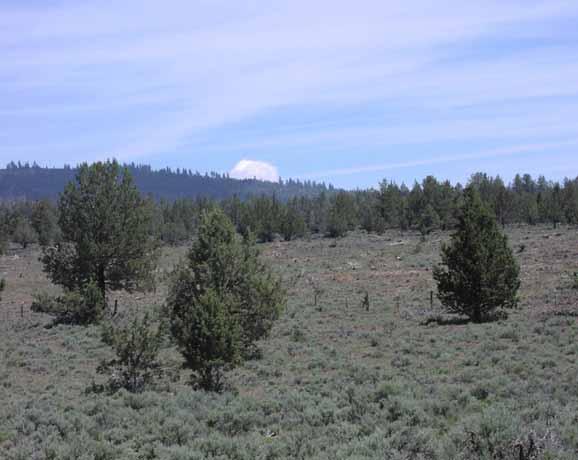
2
3 Resource Issues and Conflicts in the Upper Klamath Basin Irrigated agriculture Juniper, wetlands, riparian areas Fish survival, endangered species Water management, conservation, overallocation Hydropower production Complex hydrology, climate variability / change, drought Competing interests: farmers, Native Americans, federal agencies, PacifiCorp, wildlife refuges
4 Agricultural Sustainability in the Upper Klamath Basin Requires... Integrated consideration of resource issues and conflicts Cooperation among the many interested people Understanding of the physical system Models to predict effects of land management and conservation practices Models to forecast streamflow
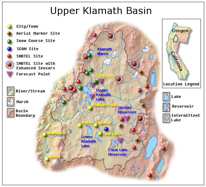
5 Sprague River Basin


6 Sprague River Basin Dry and wet


7 Cattle Grazing In the hills and pastures but sometimes too close to the river

8 Irrigated Pasture
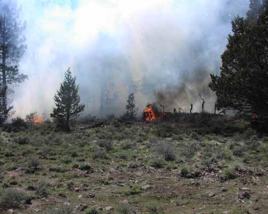
9 Juniper Encroachment and removal


10 Restoration of: Riparian areas and wetlands


11 Fish 2002 fish kill in lower Klamath Fish survival and passage within upper Klamath system
12 Hydrologic Modeling Goals Evaluate hydrologic impacts of juniper removal Evaluate hydrologic impacts of riparian zone restoration Evaluate hydrologic impacts of switching from flood to sprinkler irrigation Evaluate ability to simulate and forecast streamflow using a commonly used conceptual model (PRMS) Evaluate ability of newer, more physically explicit gridbased models to simulate and forecast snowpack and streamflow (ISNOBAL, DHSVM) Obtain better understanding of hydrology and water balance of basin
13 Hydrologic Models Used Distributed Hydrology-Soil-Vegetation Model (DHSVM) MIKE 11 / MIKE SHE Precipitation-Runoff Modeling System (PRMS) ISNOBAL


14 Spatially Distributed Hydrologic Modeling i Elevation Elevation Vegetation Land Use Soil Soil Slope Slope
15 Structure of ISNOBAL Model Solar reflectance Solar irradiance Thermal irradiance Advective heat flux Thermal exitance Latent heat flux Sensible heat flux Sublimation, Evaporation, Condensation Rain, Snow Snow layer 1 Snow layer 2 Conductive heat flux Soil Melt water outflow
16 Watershed Characteristics Basic data layers Elevation Land use / Vegetation Soil texture Soil Elevation Derived data layers Land Use Slope Slope Aspect Topo. index Flow distance LAI Root depth ET crop coeff. Porosity Wilting point Sat. hyd. cond.
17 Meteorological Forcing Data Required Precipitation Air temperature Solar radiation Relative humidity Wind speed Thermal radiation
18 Preparation of Meteorological Forcing Input Data Conceptual semi-distributed model (PRMS) requires inputs for Hydrologic Response Units (HRUs) Fully distributed models (ISNOBAL, DHSVM) require inputs for spatial grids In both cases, spatial interpolation of station data is required Time step is daily to hourly
 Interpolated")
19 40 35 Silver Creek Precipitation Precipitation (mm) Crazyman Flat Summer Rim Taylor Butte Strawberry Agency Lake Quartz Mountain Klamath Falls Gerber Reservoir 1 January 2004 Precipitation-elevation relationship Elevation (m) Interpolated spatial field
20 0.0 Klamath Falls Gerber Reservoir -1.0 Agency Lake Taylor Butte Temperature Strawberry -2.0 Crazyman Flat 1 January 2004 Temperature ( o C) Quartz Mountain Silver Creek Summer Rim Elevation (m) Temperature-elevation relationship Interpolated spatial field
21 Solar Radiation Data Sprague River Basin Solar Radiation, WY 2004, KFLO AGKO Quartz Silver Solar radiation (w/m 2 ) 12-Oct 26-Oct 9-Nov 23-Nov 7-Dec 21-Dec 4-Jan 18-Jan 1-Feb 15-Feb 29-Feb 14-Mar 28-Mar 11-Apr 25-Apr 9-May 23-May 6-Jun 20-Jun 4-Jul 18-Jul 1-Aug 15-Aug 29-Aug 12-Sep 26-Sep
22 Solar Radiation Processing Compute cosine of local illumination angle based on solar zenith angle for location and time of day and topographic slope and aspect Run elevrad for visible and near infrared to get clear sky radiation on horizontal surface at ground level Multiply by cloud correction factor Direct / diffuse split Run toporad with above inputs to get topographically-corrected beam-visible, beam-infrared, diffusevisible, and diffuse-infrared radiation Apply canopy corrections to four components Run ialbedo to get visible and near infrared clean snow albedo Compute additional albedo reduction (melt period only) and subtract from clean snow albedo Subtract reflected radiation based on albedo for four components Add four components to get total net radiation
23 Jackson Peak (2155 m)... and snow depth at a station Observed Simulated Snow Model Verification Snow water equivalent... Jackson Peak (2155 m) Observed Simulated Snow water equivalent (mm) 9-Oct 29-Oct 18-Nov 8-Dec 28-Dec 17-Jan 6-Feb 26-Feb 18-Mar 7-Apr 27-Apr 17-May 6-Jun 26-Jun Snow depth (cm) 26-Jun 9-Oct 29-Oct 18-Nov 8-Dec 28-Dec 17-Jan 6-Feb 26-Feb 18-Mar 7-Apr 27-Apr 17-May 6-Jun
 Example shown is for Boise River basin, 21 May")
24 Snow Model Verification Model simulated snow water equivalent field Satellite snow covered area (white) and forested area for which model indicated snow but satellite did not (green) Example shown is for Boise River basin, 21 May 1998

25 Snow Model Verification Snow water equivalent spatial fields from remote sensing and modeling
26 Hydrologic Model Verification Simulated Observed Flow (mm/d) 1-Mar 11-Mar 21-Mar 31-Mar 10-Apr 20-Apr 30-Apr 10-May 20-May 30-May 9-Jun 19-Jun 29-Jun 9-Jul 19-Jul 29-Jul 8-Aug 18-Aug 28-Aug
27 Ensemble Streamflow Forecasting with Hydrologic Model /1/2004 1/8/2004 1/15/2004 1/22/2004 1/29/2004 2/5/2004 2/12/2004 2/19/2004 2/26/2004 3/4/2004 3/11/2004 3/18/2004 3/25/2004 4/1/2004 4/8/2004 4/15/2004 4/22/2004 4/29/2004 5/6/2004 5/13/2004 5/20/2004 5/27/2004 Flow, in cubic feet per second

28 Conclusion The complex issues and high political visibility of the Upper Klamath Basin provide much interest in our hydrologic modeling and forecasting work. Complex geology and hydrology coupled with high spatial and temporal variability of climate make for a challenging environment in which to test our models. These modeling efforts are significant both for the scientific issues involved as well as for the practical relevance of the results.
Proposed Project. Integrated Water Resources Management Using Remote Sensing Data in Upper Indus Basin
 Proposed Project Integrated Water Resources Management Using Remote Sensing Data in Upper Indus Basin Background Snowmelt contributes more than 6% of water resources of Upper Indus Basin Most of the moisture
The Impacts of Climate Change on Portland s Water Supply
 The Impacts of Climate Change on Portland s Water Supply Richard Palmer and Margaret Hahn University of Washington Department of Civil and Environmental Engineering Joe Dvorak, Dennis Kessler, Azad Mohammadi
Hydrologic Modeling with the Distributed-Hydrology- Soils- Vegetation Model (DHSVM)
") Hydrologic Modeling with the Distributed-Hydrology- Soils- Vegetation Model (DHSVM) DHSVM was developed by researchers at the University of Washington and the Pacific Northwest National Lab 200 Simulated
Hydrologic Modeling with the Distributed-Hydrology- Soils- Vegetation Model (DHSVM) DHSVM was developed by researchers at the University of Washington and the Pacific Northwest National Lab 200 Simulated
1 THE USGS MODULAR MODELING SYSTEM MODEL OF THE UPPER COSUMNES RIVER
 1 THE USGS MODULAR MODELING SYSTEM MODEL OF THE UPPER COSUMNES RIVER 1.1 Introduction The Hydrologic Model of the Upper Cosumnes River Basin (HMCRB) under the USGS Modular Modeling System (MMS) uses a
Characterising the Surface Hydrology of Prairie Droughts
 QdroD QdfoD Qdro Qdfo SunMax C:\ Program Files\ CRHM\ Qsi global CalcHr t rh ea u p ppt Qso Qn Qln SunAct form_data calcsun Qsi hru_t hru_rh hru_ea hru_u hru_p hru_rain hru_snow hru_sunact hru_tmax hru_tmin
M.L. Kavvas, Z. Q. Chen, M. Anderson, L. Liang, N. Ohara Hydrologic Research Laboratory, Civil and Environmental Engineering, UC Davis
 Assessment of the Restoration Activities on Water Balance and Water Quality at Last Chance Creek Watershed Using Watershed Environmental Hydrology (WEHY) Model M.L. Kavvas, Z. Q. Chen, M. Anderson, L.
Piloting Utility Modeling Applications: The San Francisco Public Utilities Commission
 Piloting Utility Modeling Applications: The San Francisco Public Utilities Commission David Behar Climate Program Director Alexis Dufour, P.E. Hydrology and Water Systems Modeling PUMA Workshop December
Prairie Hydrology. If weather variability increases, this could degrade the viability of many aspects of ecosystems, human activities and economy
 Prairie Hydrology John Pomeroy, Xing Fang, Robert Armstrong, Tom Brown, Kevin Shook Centre for Hydrology, University of Saskatchewan, Saskatoon, Canada Climate Change for the Prairies? Highly variable
Using Information from Data Rich Sites to Improve Prediction at Data Limited Sites
 Using Information from Data Rich Sites to Improve Prediction at Data Limited Sites A Challenge for Hydrologic Prediction from Mountain Basins: DANNY MARKS Northwest Watershed Research Center USDA-Agricultural
Utilization of the SWAT Model and Remote Sensing to Demonstrate the Effects of Shrub Encroachment on a Small Watershed
 Utilization of the SWAT Model and Remote Sensing to Demonstrate the Effects of Shrub Encroachment on a Small Watershed Jason Afinowicz Department of Biological and Agricultural Engineering Texas A&M University
Inside of forest (for example) Research Flow
 Research Flow") Study on Relationship between Watershed Hydrology and Lake Water Environment by the Soil and Water Assessment Tool (SWAT) Shimane University Hiroaki SOMURA Watershed degradation + Global warming Background
Study on Relationship between Watershed Hydrology and Lake Water Environment by the Soil and Water Assessment Tool (SWAT) Shimane University Hiroaki SOMURA Watershed degradation + Global warming Background
SNAMP water research. Topics covered
 SNAMP water research SNAMP water team UC Merced Topics covered Objectives, goals & overview What & why the water component of SNAMP Pre-treatment Observations Water Quality Water Quantity Modeling & Scenarios:
Climate Change/Variability and Reservoir Operations
 Climate Change/Variability and Reservoir Operations 2007 CWEMF Stu Townsley Chief, Water Management Mount Action Curve Funding Public Awareness Time Corps Authority Section 7 of the 1944 Flood Control
Lecture 9A: Drainage Basins
 GEOG415 Lecture 9A: Drainage Basins 9-1 Drainage basin (watershed, catchment) -Drains surfacewater to a common outlet Drainage divide - how is it defined? Scale effects? - Represents a hydrologic cycle
M.L. Kavvas, Z. Q. Chen, M. Anderson, L. Liang, N. Ohara Hydrologic Research Laboratory, Civil and Environmental Engineering, UC Davis
 Assessment of the Restoration Activities on Water Balance and Water Quality at Last Chance Creek Watershed Using Watershed Environmental Hydrology (WEHY) Model M.L. Kavvas, Z. Q. Chen, M. Anderson, L.
Hood River Basin Study
 Hood River Basin Study Agenda 1). Goals 2). Partners 3). Study Overview 4). Recommendations Goals Evaluate: 1. Current and future water demands 2. Water conservation opportunities 3. Groundwater resources
The Surface Water Supply Index: Formulation and Issues
 The Surface Water Supply Index: Formulation and Issues David C. Garen, Ph.D. United States Department of Agriculture Natural Resources Conservation Service National Water and Climate Center Portland, Oregon,
Wapato Access Feasibility Study
 Wapato Access Feasibility Study David Gorman, PE Michael Rounds, PE August 5, 2011 Lower Columbia River Estuary Partnership (LCREP) Non-profit two state public-private initiative Primary Responsibility:
Projection of the Impact of Climate Change on the Surface Energy and Water Balance in the Seyhan River Basin Turkey
 Projection of the Impact of Climate Change on the Surface Energy and Water Balance in the Seyhan River Basin Turkey Kenji TANAKA 1, Yoichi FUJIHARA 2 and Toshiharu KOJIRI 3 1 WRRC, DPRI, Kyoto University,
Hood River Basin Study
 Hood River Basin Study Agenda 1). Goals 2). Partners 3). Study Overview 4). Recommendations Goals Evaluate: 1. Current and future water demands 2. Water conservation opportunities 3. Groundwater resources
Portland Water System & PUMA. Lorna Stickel & David Evonuk Resource Protection & Engineering Work Groups
 Portland Water System & PUMA Lorna Stickel & David Evonuk Resource Protection & Engineering Work Groups Presentation Overview 1. Background on Portland System 2. Hydrologic tools used to model our water
olumbia River Treaty The Columbia by Steve Oliver, Vice President, Generation Asset Management, Bonneville Power Administration 16 Oct
 The Columbia by Steve Oliver, Vice President, Generation Asset Management, Bonneville Power Administration 16 Oct 2006 1 Presentation Outline Geography of the Pacific Northwest Bonneville Power Administration
Camp Far West Hydroelectric Project Relicensing
 Camp Far West Hydroelectric Project Relicensing Water Operations Model FERC Project No. 2997 July 16, 2018 Overview Project and South Sutter Water District overview Operations model Overview Model Updates
Effects of Land Use On Climate and Water Resources: Application of a Land Surface Model for Land Use Management
 Effects of Land Use On Climate and Water Resources: Application of a Land Surface Model for Land Use Management Gordon Bonan, PI National Center for Atmospheric Research Boulder, Colorado Personnel Supported:
Projection of the Impact of Climate Change on the Surface Energy and Water Balance in the Seyhan River Basin Turkey
 Projection of the Impact of Climate Change on the Surface Energy and Water Balance in the Seyhan River Basin Turkey Kenji TANAKA 1, Yoichi FUJIHARA 2 and Toshiharu KOJIRI 3 1 WRRC, DPRI, Kyoto University,
Hydrological modelling research at NCAR. Martyn Clark (NCAR/RAL)
") Hydrological modelling research at NCAR Martyn Clark (NCAR/RAL) CCRN Modelling Workshop, Saskatoon Canada 15 September 2014 Outline Topics Hydrologic model development WRF-Hydro SUMMA Supporting datasets/models
Hydrological modelling research at NCAR Martyn Clark (NCAR/RAL) CCRN Modelling Workshop, Saskatoon Canada 15 September 2014 Outline Topics Hydrologic model development WRF-Hydro SUMMA Supporting datasets/models
Maintaining Water Supply Resilience in Extreme Times
 Maintaining Water Supply Resilience in Extreme Times Presented to the Western Coalition of Arid States June 20, 2018 Presentation Outline: Snapshot of Reclamation Offices West-wide Precipitation and Storage
Hydrology of Prairie Droughts
 C:\ Program Files\ CRHM\ QdroD QdfoD Qdro Qdfo SunMax global CalcHr Qsi calcsun hru_t hru_rh hru_ea hru_u hru_p hru_rain hru_snow hru_sunact hru_tmax hru_tmin hru_tmean hru_eamean hru_umean hru_rhmean
Uncertainty in hydrologic impacts of climate change: A California case study
 Uncertainty in hydrologic impacts of climate change: A California case study Ed Maurer Civil Engineering Dept. Santa Clara University Photos from USGS Motivating Questions What are potential impacts of
BAEN 673 / February 18, 2016 Hydrologic Processes
 BAEN 673 / February 18, 2016 Hydrologic Processes Assignment: HW#7 Next class lecture in AEPM 104 Today s topics SWAT exercise #2 The SWAT model review paper Hydrologic processes The Hydrologic Processes
MISSOURI RIVER BASIN WATER MANAGEMENT SPRING 2018 PUBLIC MEETINGS
 MISSOURI RIVER BASIN WATER MANAGEMENT SPRING 2018 PUBLIC MEETINGS April 17 th 10:00 a.m. Smithville, MO April 17 th 4:00 p.m. Omaha, NE April 18 th 10:00 a.m. Pierre, SD April 18 th 6:00 p.m. Bismarck,
2015 Restoration Allocation and Default Flow Schedule January 20, 2015
 Bureau of Reclamation 00 Cottage Way, MP- Sacramento, California 01 January 0, 01 1 Introduction The following transmits the 01 to the Restoration Administrator for the San Joaquin River Restoration Program
Analyzing water resources in a monsoon-driven environment an example from the Indian Western Ghats
 Analyzing water resources in a monsoon-driven environment an example from the Indian Western Ghats 1, Shamita Kumar 2, Peter Fiener 1 and Karl Schneider 1 1,,, Germany 2 Institute of Environment Education
Overview of Selected USDA Agencies and Efforts Related to Agriculture, Groundwater, and Water Availability
 Overview of Selected USDA Agencies and Efforts Related to Agriculture, Groundwater, and Water Availability Mary Scruggs Senior Advisor for Water Resources Office of the Chief Scientist United States Department
Water Supply Board Briefing. Water Operations Department March 22, 2016
 Water Supply Board Briefing Water Operations Department March 22, 2016 Water Supply Briefing California Water Supply District Water Supply Water Supply Projections Water Supply Schedule 2 California Water
Simulation and Modelling of Climate Change Effects on River Awara Flow Discharge using WEAP Model
 ANALELE UNIVERSITĂŢII EFTIMIE MURGU REŞIŢA ANUL XXIV, NR. 1, 2017, ISSN 1453-7397 Simulation and Modelling of Climate Change Effects on River Awara Flow Discharge using WEAP Model Oyati E.N., Olotu Yahaya
Columbia Basin Operations and Flood Risk Management
 Columbia Basin Operations and Flood Risk Management Julie Ammann, PE Chief, Reservoir Control Center Northwestern Division USACE US Army Corps of Engineers BUILDING STRONG The Columbia River Basin Drainage
Lecture 15: Flood Mitigation and Forecast Modeling
 Lecture 15: Flood Mitigation and Forecast Modeling Key Questions 1. What is a 100-year flood inundation map? 2. What is a levee and a setback levee? 3. How are land acquisition, insurance, emergency response
Hood River Water Conservation Strategy: achieving long-term water resource reliability for agriculture & local fish populations
 Hood River Water Conservation Strategy: achieving long-term water resource reliability for agriculture & local fish populations Cindy Thieman Hood River Watershed Group Ed Salminen & Niklas Christensen
Calibrating the Soquel-Aptos PRMS Model to Streamflow Data Using PEST
 Calibrating the Soquel-Aptos PRMS Model to Streamflow Data Using PEST Cameron Tana Georgina King HydroMetrics Water Resources Inc. California Water Environmental and Modeling Forum 2015 Annual Meeting
Managing Forests for Snowpack Storage & Water Yield
 Managing Forests for Snowpack Storage & Water Yield Roger Bales Professor & Director Sierra Nevada Research Institute UC Merced NASA-MODIS satellite image NASA-MODIS satellite image Outline of talk Mountain
The Impact of Climate Change on a Humid, Equatorial Catchment in Uganda.
 The Impact of Climate Change on a Humid, Equatorial Catchment in Uganda. Lucinda Mileham, Dr Richard Taylor, Dr Martin Todd Department of Geography University College London Changing Climate Africa has
Graham Jewitt School of Bioresources Engineering and Environmental Hydrology University of KwaZulu-Natal
 Graham Jewitt School of Bioresources Engineering and Environmental Hydrology University of KwaZulu-Natal A massive land- grabbing scramble in Africa as foreign companies - some with foreign aid money support
EVERY WET YEAR IS A MIRACLE
 EVERY WET YEAR IS A MIRACLE Drought, Climate, and Water Use in Colorado Cat Shrier Colorado State University/Colorado Climate Center Little Thompson Water District Water Forum March 15, 2003 Presentation
Using SWAT to understand the eco-hydrological response to droughts of a dry Mediterranean agro-forested catchment, southern Portugal
 GOVERNMENT OF THE PORTUGUESE REPUBLIC 213 International SWAT Conference & Workshops - Toulouse, France July 15-19, 213, Toulouse Using SWAT to understand the eco-hydrological response to droughts of a
Working with the Water Balance
 Working with the Water Balance Forest Hydrology and Land Use Change Paul K. Barten, Ph.D. Professor of Forestry and Hydrology Department of Environmental Conservation www.forest-to-faucet.org The Living
Lecture 5: Transpiration
 5-1 GEOG415 Lecture 5: Transpiration Transpiration loss of water from stomatal opening substomatal cavity chloroplasts cuticle epidermis mesophyll cells CO 2 H 2 O guard cell Evaporation + Transpiration
Lake Water Balance and Mass Balance
 Lake Water Balance and Mass Balance Surface-ground water interaction may have substantial influence on water levels and solute concentrations in lakes and wetland ponds. Water and mass balance of a lake
Application of a Basin Scale Hydrological Model for Characterizing flow and Drought Trend
 Application of a Basin Scale Hydrological Model for Characterizing flow and Drought Trend 20 July 2012 International SWAT conference, Delhi INDIA TIPAPORN HOMDEE 1 Ph.D candidate Prof. KOBKIAT PONGPUT
Missouri River Basin Water Management
 Missouri River Basin Water Management Spring 2015 Public Meetings April 7 th April 7 th April 8 th April 9 th April 9 th 11:00 a.m. 6:00 p.m. 11:00 a.m. 11:00 a.m. 6:00 p.m. Pierre, SD Bismarck, ND Fort
Water planning and climate change: actionable intelligence yet?
 Water planning and climate change: actionable intelligence yet? Christopher Milly, USGS U.S. Department of the Interior U.S. Geological Survey What is Actionable Intelligence? Information about water in
Hydrologic Pathways: Precipitation, ET, Storage, Runoff & Recharge. Joe Magner, MPCA
 Hydrologic Pathways: Precipitation, ET, Storage, Runoff & Recharge Joe Magner, MPCA Concrete! Sluice gates Channels What was the consequence Loss of 60,000 fishing jobs Initial 20 % loss of lake volume,
San Antonio Water System Mitchell Lake Constructed Wetlands Below the Dam Preliminary Hydrologic Analysis
 San Antonio Water System enhancement. This recommendation was based on limited water quality data provided by SAWS and using a free-water surface constructed wetland with approximately 112 acres of wetted
Canadian Prairie Hydrology and Runoff Generation. John Pomeroy Centre for Hydrology, University of Saskatchewan, Saskatoon
 Canadian Prairie Hydrology and Runoff Generation John Pomeroy Centre for Hydrology, University of Saskatchewan, Saskatoon www.usask.ca/hydrology Water Use in Saskatchewan Precipitation on average 350 mm
CALSIM II Sacramento River Basin Hydrology Enhancements
 CALSIM II Sacramento River Basin Hydrology Enhancements Andy Draper Walter Bourez - Montgomery Watson Harza - MBK Engineers February 26, 2004 Current representation Problems Solutions Work completed Possible
Current Water Management Practices for Kerr Reservoir
 Current Water Management Practices for Kerr Reservoir Ashley Hatchell Water Management Lake Gaston Association Monthly Meeting 03 February 2016 US Army Corps of Engineers Outline and Goals for Today s
Exercises: Glacier meteorology / Energy balance
 Summer School in Glaciology, McCarthy, 2012 Regine Hock Exercises: Glacier meteorology / Energy balance 1.) ENERGY BALANCE MELT CALCULATION A glacier is polythermal with a cold surface layer. The glacier
Climate change impacts on water resources in the Upper Po basin
 limate change impacts on water resources in the Upper Po basin Giovanni Ravazzani, Marco Mancini, hiara orbari, Alessandro eppi, Laura Boscarello, Giulia Ercolani Department of ivil and Environmental Engineering
Comments from 4/12 - Draft Responses
 Comments from 4/12 - Draft Responses Introduction The following document covers the proposed path forward and responds to questions and comments from the April 12, 2017, Stakeholder Meeting. Please review
Impact of Climate Change on Water Resources of a Semi-arid Basin- Jordan
 Impact of Climate Change on Water Resources of a Semi-arid Basin- Jordan Prof. Fayez Abdulla Civil Engineering Department Jordan University of Science & Technology Presented at the Water in an Arid Land,
Modeling the production of multiple ecosystems services from agricultural and forest landscape in Rhode Island
 Modeling the production of multiple ecosystems services from agricultural and forest landscape in Rhode Island Tingting Liu a, Nathaniel H. Merrill a, Arthur J. Gold b, Dorothy Q. Kellogg b and Emi Uchida
The Impact of Wetland Drainage on the Hydrology of a Northern Prairie Watershed
 John Pomeroy, Xing Fang, Stacey Dumanski, Kevin Shook, Cherie Westbrook, Xulin Guo, Tom Brown, Adam Minke, Centre for Hydrology, University of Saskatchewan, Saskatoon, Canada The Impact of Wetland Drainage
MODELING PHOSPHORUS LOADING TO THE CANNONSVILLE RESERVOIR USING SWAT
 MODELING PHOSPHORUS LOADING TO THE CANNONSVILLE RESERVOIR USING SWAT Bryan Tolson 1 & Christine Shoemaker 2 1. PhD Student, 2. Professor School of Civil & Environmental Engineering Cornell University PWT
Environmental Flows Allocation Process in Texas. Kevin Mayes Texas Parks and Wildlife Department March 2010
 Environmental Flows Allocation Process in Texas Kevin Mayes Texas Parks and Wildlife Department March 2010 Senate Bill 3-2007 Environmental Flow Regime A schedule of flow quantities that reflects seasonal
LOWER INTERLAKE BASIN - HYDROLOGY
 LOWER INTERLAKE BASIN - HYDROLOGY Disclaimer: The hydrologic conditions presented in this report are intended for watershed planning only and should not be used for licensing or design purposes. Utilization
NON-TREATY STORAGE AGREEMENT
 NON-TREATY STORAGE AGREEMENT Introduction to Operations and the Non Treaty Storage Scenarios Presenter: Jim Gaspard Content: System Overview Treaty Overview Modifications to Operation Supplemental Agreements
Drought, Climate Variability and Water Resources in Western Canada
 Drought, Climate Variability and Water Resources in Western Canada J.W. Pomeroy, K.R. Shook, R.N. Armstrong, X. Fang Centre for Hydrology University of Saskatchewan, Saskatoon, Canada www.usask.ca/hydrology
Overview of the Surface Hydrology of Hawai i Watersheds. Ali Fares Associate Professor of Hydrology NREM-CTAHR
 Overview of the Surface Hydrology of Hawai i Watersheds Ali Fares Associate Professor of Hydrology NREM-CTAHR 5/23/2008 Watershed Hydrology Lab 1 What is Hydrology? Hydrology is the water science that
Change for Western North America. Hydrologic Implications of Climate. and the Columbia River Basin. Dennis P. Lettenmaier. Alan F.
 Hydrologic Implications of Climate Change for Western North America and the Columbia River Basin Alan F. Hamlet, Philip W. Mote, Dennis P. Lettenmaier JISAO/CSES Climate Impacts Group Dept. of Civil and
Irrigation modeling in Prairie Ronde Township, Kalamazoo County. SW Michigan Water Resources Council meeting May 15, 2012
 Irrigation modeling in Prairie Ronde Township, Kalamazoo County SW Michigan Water Resources Council meeting May 15, 2012 Development of a Groundwater Flow Model INFLOWS Areal recharge from precipitation
EVALUATION OF HYDROLOGIC AND WATER RESOURCES RESPONSE TO METEOROLOGICAL DROUGHT IN THESSALY, GREECE
 EVALUATION OF HYDROLOGIC AND WATER RESOURCES RESPONSE TO METEOROLOGICAL DROUGHT IN THESSALY, GREECE A. LOUKAS*, AND L. VASILIADES Laboratory of Hydrology and Water Systems Analysis,, Volos, Greece *E-mail:
Climate Change and Fish in the Pacific Northwest: Case Study of the Snoqualmie River Basin
 Climate Change and Fish in the Pacific Northwest: Case Study of the Snoqualmie River Basin Pete Bisson USDA Forest Service PNW Research Station Olympia, WA U.S. Forest Service Water Strategy 2009-2019
Forests and Water in the Sierra Nevada. Roger Bales, Sierra Nevada Research Institute, UC Merced
 Forests and Water in the Sierra Nevada Roger Bales, Sierra Nevada Research Institute, UC Merced Some motivating points Water is the highest-value ecosystem service associated with Sierra Nevada conifer
Missouri River Basin Water Management Spring 2013 Public Meetings
 Missouri River Basin Water Management Spring 2013 Public Meetings April 8 th April 9 th April 9 th April 10 th April 11 th 7:00 p.m. 11:00 a.m. 7:00 p.m. 11:00 a.m. 11:00 a.m. Nebraska City, NE Fort Peck,
Prairie Hydrological Model Study Progress Report, April 2008
 Prairie Hydrological Model Study Progress Report, April 2008 Centre for Hydrology Report No. 3. J. Pomeroy, C. Westbrook, X. Fang, A. Minke, X. Guo, Centre for Hydrology University of Saskatchewan 117
Water Development Office
 THE STATE OF WYOMING Water Development Office 6920 YELLOWTAIL ROAD TELEPHONE: (307) 777-7626 CHEYENNE, WY 82002 FAX: (307) 777-6819 TECHNICAL MEMORANDUM TO: Water Development Commission DATE: November
Columbia River Operations
 Columbia River Operations P R E S E N T E D B Y Kieran Connolly Vice President Generation Asset Management Bonneville Power Administration 4 th longest river in North America; drains 258,000 square miles
Latest Information from DWR on Prop 84
 March 25, 2014 1 Introductions Forest First Workgroup Recap Prop 84 Forest First Project Monitoring Forest First Increased Water Supply Improved Water Quality Reduced Operations and Maintenance Costs Latest
ACRU HYDROLOGICAL MODELLING OF THE MUPFURE CATCHMENT
 ACRU HYDROLOGICAL MODELLING OF THE MUPFURE CATCHMENT Table of Contents: 1 INTRODUCTION... 1 2 CONFIGURATION OF ACRU... 2 2.1 RAINFALL DATA... 4 2.2 SOILS... 7 2.3 LAND COVER INFORMATION... 9 2.4 STREAM
Incorporating Climate Change Impacts into Water Resources Planning
 Incorporating Climate Change Impacts into Water Resources Planning Dr. Richard Palmer Department of Civil and Environmental Engineering University of Washington Seattle, WA 98195 www.tag.washington.edu
An Introduction to Environmental Flows
 An Introduction to Environmental Flows The natural flow regime Flow alteration Environmental flows defined Scaling up Eloise Kendy, Ph.D. IUCN workshop Kathmandu, Nepal 5 August 2011 Jefferson River, Montana
IOP Concept 5 Forecast 03 Apr 2007 to 31 Dec COE HEC-5 Simulation of IOP using hydrologic conditions of 2000 and 2001
 IOP Concept 5 Forecast 03 Apr 2007 to 31 Dec 2008 COE HEC-5 Simulation of IOP using hydrologic conditions of 2000 and 2001 HEC-5 Model Settings IOP Concept 5 Demands Hydropower Schedule based most recent
IMPACT OF LAND USE/COVER CHANGES ON STREAMFLOW:
 IMPACT OF LAND USE/COVER CHANGES ON STREAMFLOW: THE CASE OF HARE RIVER WATERSHED, ETHIOPIA Kassa Tadele and Gerd Foerch University of Siegen July 06, 2007 Presentation outline 1. Introduction Study area
Cover slide option 1 Title
 Hydrological Modeling of Koshi basin and Climate Cover slide option 1 Title Change analysis (Nepal) Ambika Khadka (Dr. Luna Bharati, Utsav Bhattarai, Pabitra Gurung) International Water Management Institute,
Illinois in Drought. June 19, 2012, Updated June 21, 2012
 June 19,, Updated June 21, Illinois in Drought The ISWS now considers central and southern Illinois to be fully in drought based on several impacts including the early season onset of reservoir drawdown
R. Srinivasan, J.H. Jacobs, J.W. Stuth, J. Angerer, R. Kaithio and N. Clarke
 Impacts of reforestation policy and agro-forestry technology on the environment and food security in the Upper Tana river basin of Kenya R. Srinivasan, J.H. Jacobs, J.W. Stuth, J. Angerer, R. Kaithio and
CIVE 641 Advanced Surface Water Hydrology. Term Project Report. Continuous Simulation of DPHM-RS for Blue River Basin
 CIVE 641 Advanced Surface Water Hydrology Term Project Report Continuous Simulation of DPHM-RS for Blue River Basin Submitted to T.Y. Gan, PhD, FASCE Professor, Dept. of Civil and Environmental Engineering
Mahurangi River. Serial No. : New Zealand-5 E ' ~ ' Area: 46.6 km 2 Origin: Hills Outlet: Mahurangi Harbour, Hauraki Gulf,
 Mahurangi River Map of River Table of Basic Data Name: Mahurangi River Serial No. : New Zealand-5 Location: Northland region, New Zealand S 36 19' ~ 36 29' E 174 36' ~ 174 41' Area: 46.6 km 2 Origin: Hills
DEPARTMENT OF GEOGRAPHY POST GRADUATE GOVT. COLLEGE FOR GIRLS.SECTOR-11 CHANDIGARH CLASS-B.A.II PAPER-A RESOURCES AND ENVIRONMENT: WORLD PATTERNS
 DEPARTMENT OF GEOGRAPHY POST GRADUATE GOVT. COLLEGE FOR GIRLS.SECTOR-11 CHANDIGARH CLASS-B.A.II PAPER-A RESOURCES AND ENVIRONMENT: WORLD PATTERNS Hydrological cycle The sun, which drives the water cycle,
SOURCE WATER MONITORING
 Monitoring and Protecting Our Water Sources SOURCE WATER MONITORING The Upper Cache la Poudre (UCLP) Watershed Collaborative Monitoring Program was established in 28 between the City of Fort Collins, the
SOLAR RADIATION ESTIMATION UNDER CLEAR SKY CONDITIONS FOR BRAŞOV AREA (ROMANIA) LINKE TURBIDITY FACTOR
 LINKE TURBIDITY FACTOR") SOLAR RADIATION ESTIMATION UNDER CLEAR SKY CONDITIONS FOR BRAŞOV AREA (ROMANIA) LINKE TURBIDITY FACTOR Elena EFTIMIE Transilvania University of Braşov, Romania Abstract. The determination of solar radiation
SOLAR RADIATION ESTIMATION UNDER CLEAR SKY CONDITIONS FOR BRAŞOV AREA (ROMANIA) LINKE TURBIDITY FACTOR Elena EFTIMIE Transilvania University of Braşov, Romania Abstract. The determination of solar radiation
A Case Study on Integrated Urban Water Modelling using Aquacycle NTUA, 2007
 A Case Study on Integrated Urban Water Modelling using Aquacycle NTUA, 2007 Contents Motivation Input Data Requirements Case Study - Greater Athens Area Model calibration and validation Formulation and
SCIENCE DESK January 13, 2004, Tuesday Alaska Thaws, Complicating the Hunt for Oil
 Will Climate Change Impact Water Supply and Demand In the Puget Sound? Richard Palmer, Matthew Wiley, and Ani Kameenui) Department of Civil and Environmental Engineering University of Washington, Seattle
Lake Simcoe Watershed Climate Change Vulnerability Assessment: Water Quantity and Quality
 Lake Simcoe Watershed Climate Change Vulnerability Assessment: Water Quantity and Quality Presentation to A.D. Latornell Conservation Symposium November 16, 2011 Eleanor Stainsby & Scott MacRitchie Vulnerability
OBSERVATIONS OF CHANGING HABITAT AND BENTHIC INVERTEBRATE COMMUNITIES FROM THE SIERRA NEVADA SENTINEL STREAM NETWORK DURING EXTENDED DROUGHT Dave
 OBSERVATIONS OF CHANGING HABITAT AND BENTHIC INVERTEBRATE COMMUNITIES FROM THE SIERRA NEVADA SENTINEL STREAM NETWORK DURING EXTENDED DROUGHT Dave Herbst, Bruce Medhurst, Ian Bell, Mike Bogan University
Hydrology in Western Colorado: Planning for Resilience
 Hydrology in Western Colorado: Planning for Resilience 2016 Water Course February 18, 2016 Dr. Gigi A. Richard Director, Hutchins Water Center at CMU Professor, Geology Coordinator, Civil Engineering Partnership
Afternoon Lecture Outline
 Afternoon Lecture Outline 1. Northern Prairies watershed hydrology 2. Solute mass balance in lakes and ponds 3. Simple mass balance simulation using MS Excel 4. Effects of sediment-water exchange on lake
5.5 Improving Water Use Efficiency of Irrigated Crops in the North China Plain Measurements and Modelling
 183 5.5 Improving Water Use Efficiency of Irrigated Crops in the North China Plain Measurements and Modelling H.X. Wang, L. Zhang, W.R. Dawes, C.M. Liu Abstract High crop productivity in the North China
Outline. Regional Overview Mine Study Area. Transportation Corridor Study Area. Streamflow Low Flow Peak Flow Snow Small Pools.
 Environmental Baseline Document Surface Water Hydrology Agency Meetings, January 31 to February 3, 2012 Anchorage, Alaska Jaime Cathcart, P.Eng., Ph.D. Outline 2 Regional Overview Mine Study Area Streamflow
For Bandon Utilities Commission
 For Bandon Utilities Commission July 12, 2017 Profile BPA, a component of the U.S. Department of Energy, is a non-profit and self-funded power marketing administration in the Pacific Northwest. Congress