Extending the societal and economic benefits of Earth science research, information, and technology
|
|
|
- Arthur Cole
- 5 years ago
- Views:
Transcription
1 NASA WATER SCIENCE & APPLICATIONS NASA S APPLIED SCIENCES PROGRAM Steven Ambrose 1, Jared Entin 2, David Toll 3 and Ted Engman 4 1- Applied Sciences Program, NASA/HQ 2-TerrestrialHydrology Program & NASA Energy Water Cycle, NASA HQ 3-Hydrological Sciences NASA/GSFC 4- Hydrological Sciences, NASA/GSFC/SAIC Extending the societal and economic benefits of Earth science research, information, and technology
2 OUTLINE NASA Applied Sciences Program Water Resources NASA Data and Data Products Applied Science Water Resources Examples How to Participate ;
3


4 NASA Remote Sensing and Modeling Systems


5 NASA Societal Benefit Areas Natural Disasters Water Resources Ecosystems Agriculture Air Quality Weather Climate Public Health


6 Goals of NASA s Hydrology Research Fundamental Research Water and Energy Cycle Science Global Hydrological Cycle Fresh Water Resources and Availability Climate Change Soil Moisture Evapotranspiration Applied Research Science Utilization Reservoir Regulation River Flow Management & Floods Agriculture Planning Hydro Power Planning Drought Assessment e Weather Forecasting Water Quality


7 NASA Data and Data Products The major space agencies and met services maintain a vast array of Earth observing satellites capable of providing basic water cycle data. These data have the potential ti for providing critical inputs for sustainable water resources planning and management. In addition, models developed from satellite data have great potential for applications.
8 Precipitation: The types of data needed include: Remote-Sensing: SSM/I, TRMM, AMSR, GOES, AVHRR, GPM In-Situ: Surface Gages and Doppler Radar Radiation: Remote-Sensing: MODIS, GOES, AVHRR In-Situ: DOE-ARM, Mesonets, USDA-ARS Surface Temperature: Remote-Sensing: AVHRR, MODIS, SSM/I, GOES In-Situ: DOE-ARM, Mesonets, NWS-ASOS, USDA-NRCS Soil Moisture: Remote-Sensing: TRMM, SSM/I, AMSR, SWAT, ESTAR, NOHRSC, SMOS In-Situ: DOE-ARM, Mesonets, Global Soil Moisture Data Bank, USDA-NRCS Groundwater: Remote-Sensing: GRACE In-Situ: Well Observations, Piezometers, pumping tests Snow Cover, Depth & Water: In-Situ: SNOTEL Streamflow: Remote-Sensing: AVHRR, MODIS, SSM/I, AMSR, GOES, NWCC, NOHRSC Remote-Sensing: Laser/Radar Altimeter (SWoT) In-Situ: Real-Time USGS, USDA-ARS Vegetation: Remote-Sensing: AVHRR, TM, VCL, MODIS, GOES In-Situ: Field Experiments Others: Soils, DEM, Latent & Sensible heat fluxes, etc.


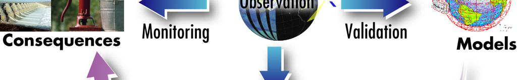
9 Research to Application GISS Model III GSFC GOCART GMAO Atmosphere Push Partnership Pull MODELS Applied Research Domain End User/ Decision Maker Benefits Terra Aqua Aura QuikScat TRMM Landsat-7 Science and Research Products User Specific Operational Products Remote Sensing Missions
10 What We Cannot Measure Directly, We Can Model Land Surface Prediction: Accurate hydrologic model prediction is essential to estimate all fluxes and storages in time and space. Based on water and energy balance. Input - Output = Storage Change P + Gin (Q + ET + Gout) = ΔS Rn - G = Le + H E T a n d P r e c i p S o u r c e A r e a O v e r l a n d F l o w In filtr a tio n S u b s u r f a c e F l o w T o t a l F l o w
11 But There Are Still Discontinuities in Space and Time Among Measured Variables and Model Produced Variables, Solution: 4 - D Land Data Assimilation Systems: Quantification and prediction of hydrologic variability (time and space) Critical for initialization and improvement of hydrologic DSTs For applications such as flood forecasting, water supply, ground water management, etc. Maturing of hydrologic observation and prediction tools: Observation: Forcing, storages (states), fluxes, and parameters. Simulation: Land process models (Hydrology). Assimilation: Short-term state constraints (satellite & in situ data) LDAS concept: Bring state-of-the-art tools together to operationally obtain high quality land surface storages and fluxes. Optimal integration of land surface observations, satellite data and model predictions. Continuous in time&space; multiple scales, realtime, and forecast O b s 4D D A M o d e l Im proved prod uct s, predictions, understanding
12 NASA Applied Sciences Program Water Resources Examples Goal: NASA Earth science routinely used in an integrated water resources approach for the U.S. & internationally for the sustainable use of water. Also includes extreme events of drought and floods and the adaptation and mitigation to climate change. For International activities many NASA satellite and modeling products (e.g., precipitation and streamflow) have applications in data poor countries of the world. NASA data are typically free with open use of data. In many cases may be obtained in near-real time and retrospectively. International work primarily through groups such as USAID, Department of State (Paul Simon Water for the Poor Act ), World Bank & GEO (Global Earth Observing) Water Resources categorized in to functional themes (Application Projects) - Streamflow and floods (includes snowpack {4-Projects} - Drought (monitoring and prediction) {4-Projects} - Irrigation and Water Delivery {3-Projects} - Water Quality {1-Project Ended} - Climate Change and Water Resources (New)
13 Water Resources Program Functional Themes Projects Summary FLOODS & STREAMFLOW FORECASTING IRRIGATION & WATER DELIVERY - Improved streamflow for NOAA River Three projects are currently addressing Forecast Centers. various aspects of improving ET - Using NASA satellite and modeling estimates for use in the BoR AWARDSproducts for Seasonal Forecast in W. US ET Toolbox and similar il DSTs. Focus on - NASA-NOAA-USGS Flash Flood using MODIS data and LDAS/LIS Project using NASA products and estimates of ET & soil moisture. One modeling. Iraqi irrigated agriculture mapping - Using NASA Snow Products and LIS for NOAA Snow and Water Forecast DROUGHT Four Projects. Two using satellite (AMSR-E, Quickscat/Sea Winds, MODIS and GRACE) and modeling/data assimilation products to improve the US Drought Monitor. Two other improving seasonal predictions and the downscaling of climate predictions for US Drought Outlook. In support of the National Integrated Drought Information System (NIDIS). WATER QUALITY Nonpoint source pollution project to assess the impact of MODIS land data products and impact of LIS precipitation and ET products to improve the continuous hydrologic model, HSPF, used in the EPA BASINS DST.
14 I. FLOODS AND STREAMFLOW FORECASTING


")

15 NASA - BUREAU OF RECLAMATION WATER SUPPLY & FORECAST Aqua Terra RiverWare Decision Support Tools (NASA) (NOAA) (BoR-USDA) Regulating Reservoirs D. Boyle/DRI NASA LIS Modeling
16 II. Water Supply and Irrigation Delivery
17 (R. Allen, University of Idaho)
18 III. Drought
 QSCAT daily")
, and USDM weekly")

 for August 2002 showing dry")
19 Drought Monitor Study by JPL/USGS/NOAA Using NASA Products (Gheim and Verdin) QSCAT daily maps of surface water increase due to precipitation (left panels), and USDM weekly drought maps (right panels) showing changes in drought conditions. AMSR-E AMSR-E monthly averaged soil moisture (volumetric %) for August 2002 showing dry conditions over western U.S..
20 IV. Water Quality


 0.33 0.62 0.")

21 NASA-EPA Study Using NASA Products for Nonpoint Source Water Quality BASINS-HSPF: Precipitation & Evapotranspiration for Flow, & Land Cover Disturbances Modeled Flow Estimations for NE Anacostia Basin STATISTICS NATIONAL vs. USGS Rain Gauges not Representative of Precipitation Correlation Coefficient Events Satellite/Doppler Spatial Data Compliments Gauge RMS Error Data Model Fit Efficiency (NS) MODIS/Landsat/Hyperion derived defoliation for NLDAS 1/8 th Degree vs. USGS estimating Nitrate exports Correlation Coefficient Chesapeake RMS Error Model Fit Efficiency (NS) Bay Watershed = BASINS default rain gauges g = NLDAS Stage II precipitation it ti
22 V. International
 for the MENA region, in which NASA satellite data, surface observations from Arab countries, and publically-available available meteorological")

23 Arab LDAS Project GOAL: Produce maps of hydrological states and fluxes in the Middle East - North Africa (MENA) region, which will serve as a basis for regional water resources assessments. METHOD: Optimize a land data assimilation system (LDAS) for the MENA region, in which NASA satellite data, surface observations from Arab countries, and publically-available available meteorological analyses will be used to parameterize, force, and constrain a sophisticated land surface model. BENEFITS: Near-real time monitoring of water resources across political boundaries Historical and regional perspective on local hydrological variability Rapid assessment of the severity and extent of droughts and floods A scientific tool for agricultural planning, including irrigation Potential to assess hydrological impacts of climate change
24 How to Participate NASA is looking for a broad range of partners, including universities, all levels of government, and private firms. Must use NASA data or products. Google NASA ROSES
American Geophysical Union Meeting H34D.
 Using NASA Products of the Water Cycle for Improved Water Resources Management Brad Doorn (NASA/HQ), David Toll (NASA/GSFC), Rick Lawford (UMBC), and E. Engman (SAIC) 15 December 2010 American Geophysical
Water Management National Application
 Water Management National Application Lawrence Friedl & Jared Entin NASA Headquarters NASA Land-Cover and Land-Use Change Science Team Meeting October 10-12, 2006 Extending the societal and economic benefits
NASA s Contribution to Water Research, Applications, and Capacity Building in Africa
 NASA s Contribution to Water Research, Applications, and Capacity Building in Africa Nancy D. Searby 1, David Toll 2, Rick Lawford 3, 1 NASA HQ Earth Sciences Division Applied Sciences Program 2 NASA GSFC
To Understand and Protect Our Home Planet: An Overview of the Applications of National Priority
 To Understand and Protect Our Home Planet: An Overview of the Applications of National Priority Jared K. Entin Program Manager, Water Management Applied Sciences Program Science Mission Directorate 1 Remote
NASA International Water Activities Towards Water Security
 National Aeronautics & NASA International Water Activities Towards Water Security David Toll Hydrological Sciences NASA/GSFC NASA Water Resources Support Bradley Doorn NASA Manager Nancy Searby NASA Capacity
Drought Indices in North America. Richard R. Heim Jr.
 Drought Indices in North America Richard R. Heim Jr. NOAA/NESDIS/ Asheville, North Carolina, USA Inter-Regional Workshop on Indices and Early Warning Systems for Drought WMO/NDMC/NOAA/UNCCD/USDA Lincoln,
Chief, Hydrological Sciences Laboratory NASA Goddard Space Flight Center
 Detection of Extreme Events with GRACE and Data Assimilation, Ph.D. Chief, Hydrological Sciences Laboratory NASA Goddard Space Flight Center Gravity Recovery and Climate Experiment (GRACE) Soil Moisture
Issues include coverage gaps, delays, measurement continuity and consistency, data format and QC, political restrictions
 Satellite-based Estimates of Groundwater Depletion, Ph.D. Chief, Hydrological Sciences Laboratory NASA Goddard Space Flight Center Greenbelt, MD Groundwater Monitoring Inadequacy of Surface Observations
The NASA Water Resources Program Role in Water Management Related to Climate and Environmental Change
 The NASA Role in Water Management Related to Climate and Environmental Change David Toll Deputy Program Manager Water Resources Hydrological Sciences NASA/GSFC Brad Doorn Manager NASA Applied Sciences
NASA Assets that Support of the Water- Energy-Food Nexus
 NASA Assets that Support of the Water- Energy-Food Nexus Richard Lawford 4 th Regional WEF Nexus Workshop Hilton, Pietermaritzburg, South Africa November 21, 2016 Observation Strategy for the Water Cycle
Agricultural Water Use and Management Using Satellite Remote Sensing
 Agricultural Water Use and Management Using Satellite Remote Sensing Ashutosh Limaye, Ph.D. SERVIR Chief Scientist, NASA Marshall Space Flight Center Linking Science to End User Needs Science End User
Weather and Climate in the FY 2016 Budget
 AAAS - The World's Largest General Scientific Society (http://www.aaas.org) Disciplinary Budgets: CHAPTER TWENTY TWO Weather and Climate in the FY 2016 Budget Paul A.T. Higgins American Meteorological
Transforming NOAA Water Resources Prediction
 Transforming NOAA Water Resources Prediction WestFAST May 18, 2017 T O O M U C H Presentation Outline Impetus for Change NOAA Water Initiative National Water Center (NWC) Status and Plans Partnerships
Lecture 15: Flood Mitigation and Forecast Modeling
 Lecture 15: Flood Mitigation and Forecast Modeling Key Questions 1. What is a 100-year flood inundation map? 2. What is a levee and a setback levee? 3. How are land acquisition, insurance, emergency response
NASA WESTERN WATER APPLICATIONS OFFICE
 NASA WESTERN WATER APPLICATIONS OFFICE Forrest Melton, Program Scientist NASA ARC-CREST Earth Science Division 650-604-2787 forrest.s.melton@nasa.gov ECOSTRESS Launch June 29, 2018, Cape Canaveral AFS
International LCLUC Regional Science Meeting in Central Asia
 International LCLUC Regional Science Meeting in Central Asia September 23, 2013 Samarkand, Uzbekistan NASA Astronaut picture from ISS Tashkent, Uzbekistan November 11-13, 2013 Shahid Habib, D.Sc., PE Chief,
NASA Earth Science Applications for Water Resource Management
 NASA Earth Science Applications for Water Resource Management Danielle Wood & Brad Doorn National Aeronautics and Space Administration NASA s current Earthobserving fleet NASA Earth Science Missions: Currently
Verifying Weather Scale Applications: Land From Evaluation to Benchmarking
 Verifying Weather Scale Applications: Land From Evaluation to Benchmarking Christa D. Peters-Lidard 1, David M. Mocko 1,2, Sujay V. Kumar 1, Grey S. Nearing 3, Youlong Xia 4,5, Michael B. Ek 6 1 NASA/GSFC;
Monitoring and modeling agricultural drought for famine early warning
 Monitoring and modeling agricultural drought for famine early warning James Verdin Chris Funk, Michael Budde, Ronald Lietzow, Gabriel Senay, Ronald Smith, Diego Pedreros 1 James Rowland, Guleid Artan 2
Alejandro (Lejo) Flores, Katelyn Watson, Matt Masarik, Megan Maksimowicz, Miguel Aguayo. Brik Royster, Brian McDevitt, Kenneth Blair, Tory Jamison
 Flores, Katelyn Watson, Matt Masarik, Megan Maksimowicz, Miguel Aguayo. Brik Royster, Brian McDevitt, Kenneth Blair, Tory Jamison") Modeler: The Increasingly Important Role of Land-Atmosphere Models for High Resolution Ecohydrologic Process Study @LEAF_Research Alejandro (Lejo) Flores, Katelyn Watson, Matt Masarik, Megan Maksimowicz,
Modeler: The Increasingly Important Role of Land-Atmosphere Models for High Resolution Ecohydrologic Process Study @LEAF_Research Alejandro (Lejo) Flores, Katelyn Watson, Matt Masarik, Megan Maksimowicz,
LAND AND WATER - EARTH OBSERVATION INFORMATICS FSP
 Earth Observation for Water Resources Management Arnold Dekker,Juan P Guerschman, Randall Donohue, Tom Van Niel, Luigi Renzullo,, Tim Malthus, Tim McVicar and Albert Van Dijk LAND AND WATER - EARTH OBSERVATION
HyMeX (*) WG2: Hydrological Continental Cycle. I. Braud (1), A. Chanzy (2) *Hydrological cycle in the Mediterranean experiment
 WG2: Hydrological Continental Cycle. I. Braud (1), A. Chanzy (2) *Hydrological cycle in the Mediterranean experiment") HyMeX (*) http://www.hymex.org/ WG2: Hydrological Continental Cycle I. Braud (1), A. Chanzy (2) (1) CEMAGREF, UR HHLY, Lyon, France (2) UME EMMAH, INRA, Avignon, France *Hydrological cycle in the Mediterranean
HyMeX (*) http://www.hymex.org/ WG2: Hydrological Continental Cycle I. Braud (1), A. Chanzy (2) (1) CEMAGREF, UR HHLY, Lyon, France (2) UME EMMAH, INRA, Avignon, France *Hydrological cycle in the Mediterranean
NOAA National Water Model: Big Voluminous Data Challenges
 NOAA National Water Model: Big Voluminous Data Challenges American Water Resources Association November 15, 2016 Edward Clark Director, Geo-Intelligence Office of Water Prediction 1 Presentation Outline
NASA Science Mission Directorate Earth Science Division Applied Sciences Program. Water Resources Application Area
 NASA Science Mission Directorate Earth Science Division Applied Sciences Program Water Resources Application Area September 27-28, 2012 Applied Sciences Program Goals Goal 1: Enhance Applications Research
Mapping Water Use and Drought with Satellite Remote Sensing
 Xiwu Zhan NOAA-NESDIS-STAR Jason Otkin University of Wisconsin Mapping Water Use and Drought with Satellite Remote Sensing Christopher Hain NASA-MSFC Li Fang, Mitch Schull Earth System Science Interdisciplinary
THE GLOBAL WATER CYCLE THEME WITHIN THE INTEGRATED GLOBAL OBSERVING STRATEGY FRAMEWORK
 THE GLOBAL WATER CYCLE THEME WITHIN THE INTEGRATED GLOBAL OBSERVING STRATEGY FRAMEWORK RICK LAWFORD & JOSEF ASCHBACHER WATER FOR THE WORLD: SPACE SOLUTIONS FOR WATER MANAGEMENT SEPTEMBER 13, 2004 GRAZ,
Southern Sierra Headwaters Tour
 Southern Sierra Headwaters Tour Introduction The headwaters of the Sierra Nevada support the needs of California s diverse downstream communities, economies, and environments. On this tour and in our research,
Potential Soil Moisture Retrieval from. PI: Prof. Lori Bruce, Ph.D Mississippi State University GeoResources Institute
 Potential Soil Moisture Retrieval from Aquarius Instrument PI: Prof. Lori Bruce, Ph.D Mississippi State University GeoResources Institute t Aquarius Evaluation Team & Collaborators MSU Team Lori Bruce
National Drought Monitoring in Canada
 National Drought Monitoring in Canada Trevor Hadwen Agriculture and Agri-Food Canada, Agri-Environmental Services Branch (AESB) National Agroclimate Information Service (NAIS) Manitoba, DRI Workshop Winnipeg,
Water Utility Modeling at Seattle Public Utilities
 PUMA Workshop December 1, 2010 San Francisco, CA Water Utility Modeling at Seattle Public Utilities Paul Fleming Manager, Climate and Sustainability Group Joan Kersnar Manager, Drinking Water Planning
Worldwide Exchange of Water Data
 Worldwide Exchange of Water Data Fernando R. Salas and David R. Maidment Center for Research in Water Resources University of Texas at Austin 2014 AWRA Spring Specialty Conference: GIS and Water Resources
WATER CYCLE VARIABLES
 WATER CYCLE VARIABLES ISSUE: THE PROPOSAL FOR A WORKSHOP FOR THE EVALUATION OF HIGH RESOLUTION GLOBAL PRECIPITATION PRODUCTS HAS NOT RECEIVED FULL FINANCIAL SUPPORT. CONCLUSION: THE ALTERNATIVES PROPOSED
Transforming NOAA Water Resources Prediction
 Transforming NOAA Water Resources Prediction Presented to APA Water and Planning Connect Conference September 12, 2018 Peter Colohan, Director Service Innovation and Partnership Division Office of Water
Risk. Management Center
 Risk Hydro-Metrologic Modeling Tools for Water Management and Analysis Management Center US Army Corps of Engineers William Charley Hydrologic Engineering Center Institute for Water Resources June 2016
Towards a National Water Modeling System
 Towards a National Water Modeling System Towards a National Water Modeling System Don Cline Chief, Hydrology Laboratory National Weather Service Jerad Bales Chief Scientist for Water U.S. Geological
Hydrological Applications of LST Derived from AVHRR
 Hydrological Applications of LST Derived from AVHRR By Balaji Narasimhan Research Assistant Department of Agricultural Engineering Texas A&M University Outline Introduction All about LST Model Development
Water Data and Modeling Services
 Water Data and Modeling Services Presented by: Fernando Salas 1 and Cindy Hooper 2 1 Center for Research in Water Resources University of Texas at Austin 2 Texas Commission on Environmental Quality October
Panel Session I - To Understand and Protect Our Home Planet
 The Space Congress Proceedings 2003 (40th) Linking the Past to the Future - A Celebration of Space Apr 29th, 10:00 AM - 11:30 AM Panel Session I - To Understand and Protect Our Home Planet NASA's Earth
Overview of Selected USDA Agencies and Efforts Related to Agriculture, Groundwater, and Water Availability
 Overview of Selected USDA Agencies and Efforts Related to Agriculture, Groundwater, and Water Availability Mary Scruggs Senior Advisor for Water Resources Office of the Chief Scientist United States Department
NASA and Carbon Management
 NASA Land-Cover and Land-Use Change Science Team Meeting NASA and Carbon Management Ed Sheffner Earth Science Division April 11, 2006 1 NASA Organization Four Mission Directorates: 1. Aeronautics 2. Exploration
Mission. Selected Accomplishments from Walnut Gulch. Facilities. To develop knowledge and technology to conserve water and soil in semi-arid lands
 USDA-ARS Southwest Watershed Research Center Mission Sound Science for Watershed Decisions To develop knowledge and technology to conserve water and soil in semi-arid lands ARS Watershed Locations Selected
Assimilation of Satellite Remote Sensing Data into Land Surface Modeling Systems
 Assimilation of Satellite Remote Sensing Data into Land Surface Modeling Systems Ming Pan Dept. of Civil and Environmental Engineering, Princeton University Presented at the Graduate Seminar at Dept. of
Remote Sensing of Water Resources
 Remote Sensing of Water Resources National Disaster Management Institute Yoomi Hur Climate Change Hydrologic Cycle Hydrologic Indices Soil Moisture Evaportranspiration Drought Conclusions 3 The water cycle
Water Data Needs and Applications in the Private Sector. Robert Annear, Vice President, Ph.D., P.E. Water is our nature
 Water Data Needs and Applications in the Private Sector Robert Annear, Vice President, Ph.D., P.E. Water is our nature GRN Forum: Global Water - 2010 and Beyond Oct 21 2010 - Oct 22 2010 Introduction Our
GEO: Understand Trends, Forecast Changes, Support Informed Decisions
 GEO: Understand Trends, Forecast Changes, Support Informed Decisions José Achache Director GEO Secretariat The Earth is a complex system of systems requiring data from many observation systems Global In-situ
Water Availability and Use Science Program. WestFAST September 24, 2015
 Water Availability and Use Science Program WestFAST September 24, 2015 WAUSP Objective To place technical information and tools in the hands of stakeholders, allowing them to answer questions they face
What is SERVIR? SERVIR-Mekong : Geospatial Data and Analysis for. Better Decision Making in the Lower Mekong Region
 SERVIR-Mekong : Geospatial Data and Analysis for Better Decision Making in the Lower Mekong Region 29 October 2015 What is SERVIR? (Sistema Regional de Visualización y Monitoreo) Partnership between USAID
Country proposal - SRI LANKA
 Country proposal - SRI LANKA P. M. Jayatilaka Banda Department of Meteorology, Nihal Rupasinghe Central Engineering Consultancy Bureau and S. B. Weerakoon University of Peradeniya, Sri Lanka Asia Water
National Aeronautics and Space Administration. Annual Report. NASA Earth Science Applied Sciences Program
 National Aeronautics and Space Administration 2012 Annual Report NASA Earth Science Applied Sciences Program Letter from the Director Lawrence Friedl, Director, Applied Sciences Program Welcome to the
Science Mission Directorate Carbon Cycle & Ecosystems Roadmap NACP
 Science Mission Directorate Carbon Cycle & Ecosystems Roadmap NACP Bill Emanuel Program Scientist, Terrestrial Ecology Carbon Cycle & Ecosystems Focus Area Carbon Cycle & Ecosystems Focus Area Program
Agricultural Systems Modeling: Challenges and Opportunities
 Agricultural Systems Modeling: Challenges and Opportunities Ghassem R. Asrar Deputy Administrator Natural Resources & Sustainable Agricultural Systems USDA Agricultural Research Service Agricultural Science
1 THE USGS MODULAR MODELING SYSTEM MODEL OF THE UPPER COSUMNES RIVER
 1 THE USGS MODULAR MODELING SYSTEM MODEL OF THE UPPER COSUMNES RIVER 1.1 Introduction The Hydrologic Model of the Upper Cosumnes River Basin (HMCRB) under the USGS Modular Modeling System (MMS) uses a
Welcome to a Webinar on the National Oceanic and Atmospheric Administration. Silver Jackets Webinar Series Partnering Opportunities No.
 Welcome to a Webinar on the National Oceanic and Atmospheric Administration Silver Jackets Webinar Series Partnering Opportunities No. 4 May 31, 2017 Peter Colohan Director of Service Innovation and Partnership
SCIE 4104E - Environmental Systems Science. Tarendra Lakhankar NOAA-CREST Center, The City University of New York
 SCIE 4104E - Environmental Systems Science Tarendra Lakhankar NOAA-CREST Center, The City University of New York About Class This course focuses on Earth as a system and explores the interdependent relationships
Remotely-Sensed Fire Danger Rating System to Support Forest/Land Fire Management in Indonesia
 Remotely-Sensed Fire Danger Rating System to Support Forest/Land Fire Management in Indonesia Orbita Roswintiarti Indonesian National Institute of Aeronautics and Space (LAPAN) SE Asia Regional Research
USDA-NRCS, Portland, Oregon
 Hydrologic Simulation Modeling for Streamflow Forecasting and Evaluation of Land and Water Management Practices in the Sprague River, Upper Klamath Basin, Oregon, USA David Garen John Risley Jolyne Lea
Societal Benefits of GEWEX And Related Water Cycle Research
 Societal Benefits of GEWEX And Related Water Cycle Research Rick Lawford GEWEX/iLEAPS Conference August 2009 Melbourne, Australia GEWEX: TURNING OBSERVATIONS INTO SCIENTIFIC KNOWLEDGE 1) TO SUPPORT IMPROVED
The NASA Soil Moisture Active Passive (SMAP) mission: Overview
 mission: Overview") The NASA Soil Moisture Active Passive (SMAP) mission: Overview The MIT Faculty has made this article openly available. Please share how this access benefits you. Your story matters. Citation As Published
The NASA Soil Moisture Active Passive (SMAP) mission: Overview The MIT Faculty has made this article openly available. Please share how this access benefits you. Your story matters. Citation As Published
Using Information from Data Rich Sites to Improve Prediction at Data Limited Sites
 Using Information from Data Rich Sites to Improve Prediction at Data Limited Sites A Challenge for Hydrologic Prediction from Mountain Basins: DANNY MARKS Northwest Watershed Research Center USDA-Agricultural
Calibrating the Soquel-Aptos PRMS Model to Streamflow Data Using PEST
 Calibrating the Soquel-Aptos PRMS Model to Streamflow Data Using PEST Cameron Tana Georgina King HydroMetrics Water Resources Inc. California Water Environmental and Modeling Forum 2015 Annual Meeting
California s water cycle: climate, snowpack & forest management
 California s water cycle: climate, snowpack & forest management Roger Bales Professor & Director Sierra Nevada Research Institute UC Merced UC Merced NASA-MODIS satellite image SNRI mission Foster interdisciplinary
The Western States Water Mission CUAHSI Hydroinformatics meeting 16 July 2015
 Jet Propulsion Laboratory, California Institute of Technology The Western States Water Mission CUAHSI Hydroinformatics meeting 16 July 2015 Water Cycle and Freshwater Availability Next Challenge : Adding
Drought Early Warning System for the Tribes of the Missouri Basin
 Drought Early Warning System for the Tribes of the Missouri Basin Great Plains Tribal Water Alliance: Water Conference 2016 Doug Kluck, Regional Climate Services Director Kansas City, MO National Center
Proposed Project. Integrated Water Resources Management Using Remote Sensing Data in Upper Indus Basin
 Proposed Project Integrated Water Resources Management Using Remote Sensing Data in Upper Indus Basin Background Snowmelt contributes more than 6% of water resources of Upper Indus Basin Most of the moisture
Transforming NOAA Water Resources Prediction
 Transforming NOAA Water Resources Prediction presented to Community Advisory Committee for the Office of Water Prediction (CAC-WP) January 30, 2018 Thomas Graziano, Ph.D. Director, Office of Water Prediction
Water quality and remote sensing in NASA Applied Sciences. Christine M. Lee NASA Earth Science Division Applied Sciences Program
 Water quality and remote sensing in NASA Applied Sciences Christine M. Lee NASA Earth Science Division Applied Sciences Program Great Lakes Workshop Series on Remote Sensing of Water Quality March 12-13,
The Spatial Analysis between SWAT Simulated Soil Moisture, and MODIS LST and NDVI Products
 Konkuk University, Seoul, South Korea The Spatial Analysis between SWAT Simulated Soil Moisture, and MODIS LST and NDVI Products Geun Ae PARK Post-doctoral Researcher, Dept. of Civil and Environmental
Long-term forecasting of natural disasters under projected climate changes in Ukraine
 Scientific Centre for Aerospace Research of the Earth National Academy of Sciences of Ukraine 55-b, O. Honchar street, Kiev, 01601, Ukraine phone/fax: (+38 044) 486 1148 URL: www.casre.kiev.ua; Е-mail:
Adaption to climate change: New technologies for water management and impact assessment
 Adaption to climate change: New technologies for water management and impact assessment Wim Bastiaanssen Director WaterWatch (NL) Professor at Delft University of Technology (NL) Some selected problems
State Perspectives on Water and Climate Planning and Management
 State Perspectives on Water and Climate Planning and Management 4th BINATIONAL WATER AND CLIMATE WORKSHOP Hermosillo, Sonora Linda Stitzer, Arizona Department of Water Resources lsstitzer@azwater.gov State
Evaporation from a temperate closed-basin lake and its impact on present, past, and future water level
 Evaporation from a temperate closed-basin lake and its impact on present, past, and future water level Ke Xiao, Tim Griffis, John Baker, Paul Bolstad, Matt Erickson, Xuhui Lee, Jeff Wood, Cheng Hu Presenter:
Hydrological Modeling of the Black Sea Catchment using SWAT
 South Korea, August, 2010 Hydrological Modeling of the Black Sea Catchment using SWAT Elham Rouholahnejad elham.rouholahnejad@ eawag.ch Content: Part 1: Black Sea General Information Part 2: envirogrids
Assessing the robustness of spring snowpack as a drought indicator in the Upper Colorado River Basin under future climate change
 Assessing the robustness of spring snowpack as a drought indicator in the Upper Colorado River Basin under future climate change Ben Livneh, Andrew Badger, Jeffrey Lukas, and Lisa Dilling Cooperative Institute
geoland HALO Workshop Issue I.1.00 Observatory of Natural Carbon fluxes Jean-Christophe Calvet and the geoland / ONC Team
 Observatory of Natural Carbon fluxes HALO Workshop Issue I.1.00 Jean-Christophe Calvet and the / ONC Team November 2004 ONC overview ONC tools ONC implementation ONC first results Conclusions November
CMS and Decision Support Discussion Forum: Current and Near-term Satellite Assets
 CMS and Decision Support Discussion Forum: Current and Near-term Satellite Assets February 6, 2013 Diane E. Wickland 1 and Marc L. Imhoff 2 1 - NASA HQ, Science Mission Directorate, Earth Science Division
Assessment of Ecosystem services with considering impact of Climate change on Godavari basin. Indian Institute of Technology Hyderabad, India
 Assessment of Ecosystem services with considering impact of Climate change on Godavari basin Amarnath C R Research Scholar Dr. Shashidhar Associate Professor Indian Institute of Technology Hyderabad, India
Managing Forests for Snowpack Storage & Water Yield
 Managing Forests for Snowpack Storage & Water Yield Roger Bales Professor & Director Sierra Nevada Research Institute UC Merced NASA-MODIS satellite image NASA-MODIS satellite image Outline of talk Mountain
TOWARDS THE DEVELOPMENT OF DROUGHT MASTER PLAN FOR GREECE
 TOWARDS THE DEVELOPMENT OF DROUGHT MASTER PLAN FOR GREECE Christos A. Karavitis, Water Resources Management Agricultural University of Athens AUA, Hellas TECHNICAL SUPPORT TO THE CENTRAL WATER AGENCY FOR
Multi-variate Analysis of National Scale Hydrologic Simulations & Predictions: NFIE 2015
 Multi-variate Analysis of National Scale Hydrologic Simulations & Predictions: NFIE 2015 NCAR: D. Gochis, A. Dugger, L. Pan, W. Yu, K. Sampson, J. McCreight, Y. Zhang, D. Yates U. Texas-Austin: M. Somos,
Flood Monitoring WG - Activities Report -
 Flood Monitoring WG - Activities Report - Kazuhiko FUKAMI (ICHARM) & Hiroaki KAI (JAXA) March 13, 2007 3 rd JPT Meeting, Singapore Edited by PWRI with data from CREDO Disaster with death toll of more than
Module 9 (L35 L37): Drought Management : Drought assessment and classification, drought. 36 Drought Analysis
: Drought Management : Drought assessment and classification, drought. 36 Drought Analysis") Module 9 (L35 L37): Drought Management : Drought assessment and classification, drought analysis techniques, drought mitigation planning. 36 Drought Analysis 1 1 L36 L36 Drought Analysis Topics Covered
Module 9 (L35 L37): Drought Management : Drought assessment and classification, drought analysis techniques, drought mitigation planning. 36 Drought Analysis 1 1 L36 L36 Drought Analysis Topics Covered
The 4th GEOSS AWCI ICG Meeting Kyoto, 6-7 February WEB-DHM and IWRM
 The 4th GEOSS AWCI ICG Meeting Kyoto, 6-7 February 29 WEB-DHM and IWRM Lei Wang a, Toshio Koike a, Cho Thanda Nyunt a, Oliver Cristian Saavedra Valeriano a, Tran Van Sap b, Tsugito Nagano c a Department
CHAPTER ONE : INTRODUCTION
 CHAPTER ONE : INTRODUCTION WHAT IS THE HYDROLOGY? The Hydrology means the science of water. It is the science that deals with the occurrence, circulation and distribution of water of the earth and earth
The Development of Hydrological Services
 The Development of Hydrological Services Bruce Stewart President of the WMO Commission for Hydrology Abstract The primary objective of any Hydrological Service (HS) is the management of water resources
NASA s Applied Remote Sensing Training Program (ARSET): Building Capacity for Flood Monitoring
: Building Capacity for Flood Monitoring") NASA s Applied Remote Sensing Training Program (ARSET): Building Capacity for Flood Monitoring Dr. Ana. I. Prados and Amita V. Mehta Joint Center for Earth Systems Technology (JCET) University of Maryland
NASA s Applied Remote Sensing Training Program (ARSET): Building Capacity for Flood Monitoring Dr. Ana. I. Prados and Amita V. Mehta Joint Center for Earth Systems Technology (JCET) University of Maryland
California water, mountain hydrology, & UC Merced
 California water, mountain hydrology, & UC Merced Roger Bales Acting Director, Sierra Nevada Research Institute Professor, School of Engineering University of California, Merced Snowcover & climate Remote
Oregon Water Conditions Report January 11, 2017
 Oregon Water Conditions Report January 11, 2017 Above average mountain snowpack continues to build. Cooler temperatures combined with recent weather events have contributed to a continued increase in mountain
Managing Drought Risk in a Changing Climate: The Role of National Drought Policy
 Managing Drought Risk in a Changing Climate: The Role of National Drought Policy Dr. Donald A. Wilhite School of Natural Resources University of Nebraska-Lincoln National Drought Management Policy Workshop,
Role of NIDIS in Measuring, Quantifying, & Reporting Drought Impacts
 Role of NIDIS in Measuring, Quantifying, & Reporting Drought Impacts Western States Water Council August 5-7, 2013, San Diego, CA Veva Deheza, NIDIS Regional Drought Information Coordinator Socio-economic
The Impacts of Climate Change on Portland s Water Supply
 The Impacts of Climate Change on Portland s Water Supply Richard Palmer and Margaret Hahn University of Washington Department of Civil and Environmental Engineering Joe Dvorak, Dennis Kessler, Azad Mohammadi
A Methodology for Using Surface Wetness to Measure Flow in International River Basins: Application to the Zambezi, Mekong and Red River Basins
 A Methodology for Using Surface Wetness to Measure Flow in International River Basins: Application to the Zambezi, Mekong and Red River Basins Brian Blankespoor, Alan Basist, Neil Thomas World Bank, Eyes
Forecast Informed Reservoir Operations An Opportunity to Improve the Resiliency of our Water Supply
 Forecast Informed Reservoir Operations An Opportunity to Improve the Resiliency of our Water Supply Western States Water Council S2S Precipitation Forecasting May 17, 2017 San Diego, California Jay Jasperse,
Soil Moisture Mapping
 Soil Moisture Mapping with UAS an Advanced UAS for Environmental Monitoring info@blackswifttech.com Figure 1: The Black Swift Technologies S2TM and its soil moisture monitoring payload. Introduction ter
WORKSHOP ESA/CLIMATE CHANGE INITIATIVE (CCI+)
") WORKSHOP ESA/CLIMATE CHANGE INITIATIVE (CCI+) 19 th July 2016 Angelica Tarpanelli, Luca Brocca, Christian Massari, Luca Ciabatta, Stefania Camici, Silvia Barbetta, Tommaso Moramarco http://hydrology.irpi.cnr.it
WORKSHOP ESA/CLIMATE CHANGE INITIATIVE (CCI+) 19 th July 2016 Angelica Tarpanelli, Luca Brocca, Christian Massari, Luca Ciabatta, Stefania Camici, Silvia Barbetta, Tommaso Moramarco http://hydrology.irpi.cnr.it
Representing the Integrated Water Cycle in Community Earth System Model
 Representing the Integrated Water Cycle in Community Earth System Model Hong-Yi Li, L. Ruby Leung, Maoyi Huang, Nathalie Voisin, Teklu Tesfa, Mohamad Hejazi, and Lu Liu Pacific Northwest National Laboratory
Advanced Observing Systems and S2S Forecasting California Investments
 Advanced Observing Systems and S2S Forecasting California Investments Dr. Michael Anderson, CA State Climatologist WSWC S2S Workshop May 14, 2018 Talk Overview Motivation History of the Past Decade Current
CROP STATE MONITORING USING SATELLITE REMOTE SENSING IN ROMANIA
 CROP STATE MONITORING USING SATELLITE REMOTE SENSING IN ROMANIA Dr. Gheorghe Stancalie National Meteorological Administration Bucharest, Romania Content Introduction Earth Observation (EO) data Drought
HKH-HYCOS regional flood information system and its benefits to SAsiaFFG system
 HKH-HYCOS regional flood information system and its benefits to SAsiaFFG system First Steering Committee Meeting (SCM 1) New Delhi, INDIA 26-28 April 2016 Mandira Singh Shrestha International Centre for
Management of Natural and Environmental Resources for Sustainable Agricultural Development. Regional Diversity & Change over the Pacific Northwest
 Management of Natural and Environmental Resources for Sustainable Agricultural Development Regional Diversity & Change over the Pacific Northwest (Maritime, Rangeland, Riparian, Desert, and Forest) By
Watershed Modeling of Copper Loads to San Francisco Bay
 Watershed Modeling of Copper Loads to San Francisco Bay Tony Donigian AQUA TERRA Consultants Brake Pad Partnership Stakeholder Conference July 31, 2007 Watershed Model Objectives - Provide daily loadings