1645 Dutch Fork Road Irmo, South Carolina
|
|
|
- Morris Simmons
- 5 years ago
- Views:
Transcription
1 For Sale Du tc hf or kr ±5.38 AC d 97 0 '± Site Dutch Fork Road Irmo, South Carolina For more information: Property Features ±5.38 Acres for sale in Irmo, SC ±970 feet of road frontage on Dutch Fork Road Water and sewer in area Parcel #: R ± Acres Primary Zoning: RU, Rural District (Richland 5.38 County) Secondary Zoning: RS-LD Residential, Single-Family - Low Density District (Richland County) Traffic Count: 23,600 VPD (Station 145) Sales Price: $672,500 Map Updated: Wednesday, October 25, This information submitted is not guaranteed. Although obtained from reliable sources, all information should be Tombo Milliken Tom Milliken tombo.milliken@naiavant.com tmilliken@naiavant.com THE INFORMATION CONTAINED HEREIN HAS BEEN GIVEN TO US BY THE OWNER OF THE PROPERTY OR OTHER SOURCES WE DEEM RELIABLE. WE HAVE NO REASON TO DOUBT ITS ACCURACY, BUT WE DO NOT GUARANTEE IT. ALL INFORMATION SHOULD BE VERIFIED PRIOR TO PURCHASE OR LEASE. 807 Gervais Street, Suite 301 Columbia, South Carolina
2 Location Broad River Rd Lake Murray of Richland Site^ Ballentine Park 26 Dreher Shoals Rd Irmo Lake Murray UV 6


3 Points of Interest Ballentine Stow-Away Storage Security Federal Burger King Aderley Blimpie YoFresh Yogurt Cafe Ballentine Crossing 315 Units Broad River Rd 26 Arbor Springs 165 Lots Lake Murray Liberty on the Lake Site Cedar Mill 70 Lots San Jose First Citizens CVS: Minute Clinic Ballentine Storage Hardees Ballentine Market Food Lion Lake Murray Liquors Dollar General! Millford Park Bickley Elementary 2016 Traffic Count: 23,600 VPD Burger King Dutch Fork Crossing Walmart Dollar Tree Sonic Little Caesars Popeyes Taco Bell Walgreens The Park at Lake Murray 56 Units Planned The Pointe at Lake Murray 56 Units Planned Carolina Matress AT&T 176 Express Oil Chick-Fil-A Tractor Supply Co. ") The Residence at Marina Bay 216 Units Crystal Cove 18 Lots UV 6 Wyndhurst 46 Lots Rose Oaks 90 Lots

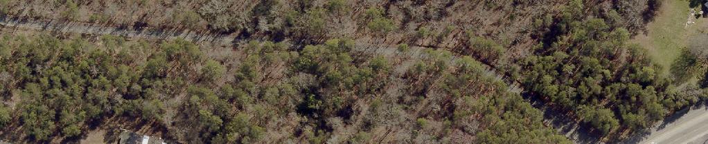
4 2017 Aerial 970' ±

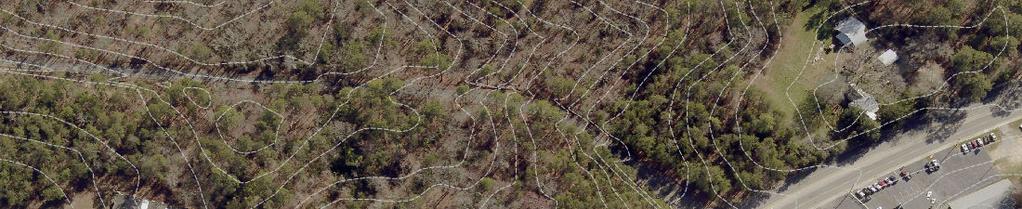
5 Topographical Map: 2' Contours
6 Topographical Map: 10' Contours


7 FEMA National Flood Hazard Layer
8 National Wetlands Inventory National Wetlands Inventory Estuarine and Marine Deepwater Estuarine and Marine Wetland Freshwater Emergent Wetland Freshwater Forested/Shrub Wetland Freshwater Pond Lake Riverine


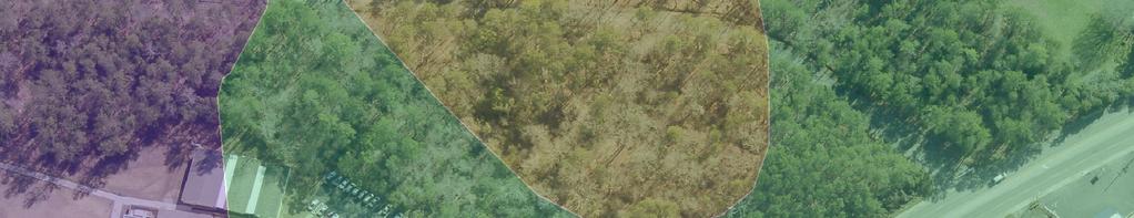
9 Soil Survey OaB GeB NaB NaC
10 Map Unit Description (Brief, Generated) Richland County, South Carolina [Minor map unit components are excluded from this report] Map unit: GeB - Georgeville silt loam, 2 to 6 percent slopes Component: Georgeville (85%) The Georgeville component makes up 85 percent of the map unit. Slopes are 2 to 6 percent. This component is on interfluves, piedmonts. The parent material consists of residuum weathered from metavolcanics and/or residuum weathered from metasedimentary rock and/or residuum weathered from slate. Depth to a root restrictive layer is greater than 60 inches. The natural drainage class is well drained. Water movement in the most restrictive layer is moderately high. Available water to a depth of 60 inches is high. Shrink-swell potential is low. This soil is not flooded. It is not ponded. There is no zone of water saturation within a depth of 72 inches. Organic matter content in the surface horizon is about 1 percent. Nonirrigated land capability classification is 2e. This soil does not meet hydric criteria. Map unit: NaB - Nason silt loam, 2 to 6 percent slopes Component: Nason (100%) The Nason component makes up 100 percent of the map unit. Slopes are 2 to 6 percent. This component is on hillslopes on uplands. The parent material consists of clayey residuum weathered from slate. Depth to a root restrictive layer, bedrock, paralithic, is 40 to 60 inches. The natural drainage class is well drained. Water movement in the most restrictive layer is moderately high. Available water to a depth of 60 inches is moderate. Shrink-swell potential is moderate. This soil is not flooded. It is not ponded. There is no zone of water saturation within a depth of 72 inches. Organic matter content in the surface horizon is about 2 percent. Nonirrigated land capability classification is 2e. This soil does not meet hydric criteria. Survey Area Version: 15 Survey Area Version Date: 12/23/2013 Page 1

11 Map Unit Description (Brief, Generated) Richland County, South Carolina Map unit: NaC - Nason silt loam, 6 to 10 percent slopes Component: Nason (100%) The Nason component makes up 100 percent of the map unit. Slopes are 6 to 10 percent. This component is on hillslopes on uplands. The parent material consists of clayey residuum weathered from slate. Depth to a root restrictive layer, bedrock, paralithic, is 40 to 60 inches. The natural drainage class is well drained. Water movement in the most restrictive layer is moderately high. Available water to a depth of 60 inches is moderate. Shrink-swell potential is moderate. This soil is not flooded. It is not ponded. There is no zone of water saturation within a depth of 72 inches. Organic matter content in the surface horizon is about 2 percent. Nonirrigated land capability classification is 3e. This soil does not meet hydric criteria. Map unit: OaB - Orange loam, 0 to 4 percent slopes Component: Orange (100%) The Orange component makes up 100 percent of the map unit. Slopes are 0 to 4 percent. This component is on marine terraces on coastal plains. The parent material consists of clayey residuum weathered from slate. Depth to a root restrictive layer, bedrock, lithic, is 40 to 60 inches. The natural drainage class is somewhat poorly drained. Water movement in the most restrictive layer is moderately high. Available water to a depth of 60 inches is low. Shrink-swell potential is low. This soil is not flooded. It is not ponded. A seasonal zone of water saturation is at 12 inches during January, February, March, December. Organic matter content in the surface horizon is about 2 percent. Nonirrigated land capability classification is 3e. This soil does not meet hydric criteria. Survey Area Version: 15 Survey Area Version Date: 12/23/2013 Page 2
1645 Dutch Fork Road Irmo, South Carolina
 For Sale Du tc ±5.38 AC hf or kr d 97 0 '± Site 76 1645 Dutch Fork Road Irmo, South Carolina Property Features Map Updated: Wednesday, October 25, 2017. This information submitted is not guaranteed. Although
±3.00 Acres Land Available
 11134 Broad River Peak Exit Mini Storage For Sale ±3.00 Acres Land Available 10,200 VPD ±324' Broad River Village Broad River Road Ballentine, SC Additional Features ±3.00 acres of land available for sale
Off Columbiana Drive Columbia, South Carolina
 For Sale ±22.11 AC Commercial Land lvd yb e Lak ra Mur N. row od Wo ree St To D t Site ±6.22 acres available Co lum bia na Dr ive ow nto wn Co lum bia Broad River Road Off Columbiana Drive Columbia, South
±0.33 AC. 927 Chapin Road Chapin, South Carolina. Site. Property Features. Gerald Steele
 For Sale ±0.33 AC Site 927 Chapin Road Chapin, South Carolina Gerald Steele +1 803 744 9851 gsteele@naiavant.com Property Features ±0.33 AC for sale in Chapin Water and sewer in area Zoning: GC, General
Blythewood Road Blythewood, South Carolina
 For Sale Golf Club 917 Lots ±141.5 Acres 77 Blythewood Park Bethel-Hanberry Elementary School Dollar General @ McNulty Plaza Food Lion @ Village at Blythewood " " Recreation Center " Future Sharpe Shoppe
Amicks Ferry Road Lexington, South Carolina
 For Sale ±1.96 Acres Lake Murray Amicks Ferry Rd. Amicks Ferry Road Lexington, South Carolina For more information: Gerald Steele +1 803 744 9851 gsteele@naiavant.com Property Features ±1.96 acres available
4777 Sunset Boulevard Lexington, South Carolina
 For Sale ±2.2 AC Unicar Enterprise Hudson Brothers Automotive John Harris Body Shop Site 4777 Sunset Boulevard Lexington, South Carolina Gerald Steele +1 803 744 9851 gsteele@naiavant.com Property Features
Columbia Avenue Chapin, South Carolina
 FUTURE Chapin Business & Technology Park at Brighton For Sale ±5.14 AC LMC Community Medical Center ( D VP 0,80 13 Farm Boys ( Brighton Blvd Site le g Ea UNDERWAY Palmetto Bone & Joint b um l Co e Av a
±180 AC. Bull Swamp Road North, South Carolina. For Sale. Tombo Milliken
 PRICE REDUCED For Sale ±180 AC Bull Swamp Road North, South Carolina CONTACT BROKERS FOR MORE INFORMATION: Tombo Milliken +1 803 744 9852 tombo.milliken@naiavant.com Tom Milliken +1 803 744 9837 tmilliken@naiavant.com
Koon Road Lugoff, South Carolina
 For Sale ±105 AC Pasture Land w/ Pond Koon Road Lugoff, South Carolina Tombo Milliken +1 803 206 8384 tombo.milliken@naiavant.com Tom Milliken +1 803 331 6999 tmilliken@naiavant.com THE INFORMATION CONTAINED
Bookman Road. Site. Columbia, South Carolina. For Sale ±16.12 AC Industrial Land. 015 Aerial. For more information:
 015 Aerial For Sale ±16.12 AC Industrial Land Site Bookman Road Columbia, South Carolina For more information: Tom Milliken +1 803 744 9837 tmilliken@naiavant.com Tombo Milliken +1 803 744 9852 tombo.milliken@naiavant.com
Jacobs Mill Pond Road Elgin, South Carolina
 PRICE REDUCED For Sale ±1.5 AC Retail/Showroom Site Spears Creek Church Rd Spears Creek Church Ln Percival Rd Jacobs Mill Pond Road Elgin, South Carolina CONTACT BROKERS FOR MORE INFORMATION: Tombo Milliken
McLean Road. Site. Blythewood, South Carolina. For Sale ±4.58 Acres. For more information: Tom Milliken
 For Sale ±4.58 Acres Oakhurst Rd Mcnulty St 21 Main St Wilson Blvd Site Blythewood Community Center & Town Hall Sandfield Rd Boney Rd Langford Rd Blythewood Rd McLean Road Blythewood, South Carolina For
± AC For Sale or Ground Lease
 Heavy Industrial Land on Rail ±113.24 AC For Sale or Ground Lease Wilson Blvd Located along Railroad Farrow Road Columbia, South Carolina Tombo Milliken +1 803 744 9852 tombo.milliken@naiavant.com Tom
Fontaine Business Center Columbia, South Carolina
 555 Site A ± 2.17 Acres For Sale ±6.18 AC Fontaine Business Center Two Lots Available Site B ± 4.01 Acres Fontaine Business Center Columbia, South Carolina CONTACT BROKERS FOR MORE INFORMATION: Cam Kreps
±39.5 AC: Fish Hatchery & New Cassell Road
 E Indian River Golf Club Food Lion at Congaree Commons South Congaree Main St Styx State Fish Hatchery Pine Ridge Pine Ridge Armory Charwood Country Club Lexington County Industrial Park Pine Ridge Rd
Killian Road. Site. For Sale ±32.21 AC. Vacant Land. Columbia, South Carolina. Property Features. Cam Kreps
 For Sale ±32.21 AC Vacant Land Killian Road Columbia, South Carolina Site Property Features ±32.21 acres for sale ±1,462 feet of road frontage on. Suitable uses include single family home subdivision,
9650 Two Notch Road Columbia, South Carolina
 For Sale D E UC ±7.92 AC D E IC RE Commercial Land PR Two ch Not d Roa Site 9650 Two Notch Road Columbia, South Carolina THE INFORMATION CONTAINED HEREIN HAS BEEN GIVEN TO US BY THE OWNER OF THE PROPERTY
Corner of Colite Drive & Platt Springs Road Columbia, South Carolina
 PRICE REDUCED For Sale ±2262 Acres Colite Drive Platt Springs Road Corner of Colite Drive & Platt Springs Road Columbia, South Carolina For more information: Rob Lapin +1 803 744 9834 rlapin@naiavantcom
Background. Literature Review
 Ms. Joanna Helms Economic Development Director Town of Apex 73 Hunter Street P.O. Box 250 Apex, North Carolina 27502 October 23, 2015 Reference: Report of Wetland Determination Cash Perkins Site ECS Project
CHAPTER 7 PHYSICAL INVENTORY OF THE CITY
 CHAPTER 7 PHYSICAL INVENTORY OF THE CITY Chapter 7: Physical Inventory of the City 39 This page intentionally left blank. Chapter 7: Physical Inventory of the City 40 SECTION 1 PHYSICAL SETTING While communities
DEPARTMENT OF GENERAL SERVICES NATURAL RESOURCES DIVISION INTEROFFICE MEMORANDUM
 DEPARTMENT OF GENERAL SERVICES NATURAL RESOURCES DIVISION INTEROFFICE MEMORANDUM TO: Board of County Commissioners VIA: Terry Shannon, County Administrator VIA: V. Wilson Freeland, Director, Department
Decision Notice, Finding of No Significant Impact
 United States Department of Agriculture Forest Service Decision Notice, Finding of No Significant Impact Cherokee National Forest 2011 Suppression of Hemlock Woolly Adelgid Infestations Cherokee National
Landmark Business Park Forest Acres - Columbia, South Carolina
 Landmark I Landmark II Landmark IV Landmark Business Park Forest Acres - Columbia, South Carolina For more information: Peyton Bryant +1 803 744 9876 +1 803 917 7786 pbryant@naiavant.com THE INFORMATION
Landmark Business Park Forest Acres - Columbia, South Carolina
 Landmark I Landmark II Landmark IV Landmark Business Park Forest Acres - Columbia, South Carolina For more information: Peyton Bryant +1 803 744 9876 +1 803 917 7786 pbryant@naiavant.com THE INFORMATION
Rock Sock (RS) Rock Sock height.
 Rock Sock height.") Rock Sock (RS) SC-5 Description A rock sock is constructed of gravel that has been wrapped by wire mesh or a geotextile to form an elongated cylindrical filter. Rock socks are typically used either as
Rock Sock (RS) SC-5 Description A rock sock is constructed of gravel that has been wrapped by wire mesh or a geotextile to form an elongated cylindrical filter. Rock socks are typically used either as
The Big Picture SOILS, WETLANDS AND DEVELOPMENT SOILS OVERVIEW BRUCE BARBER. PWS, Soil Scientist Certified Ecologist CORNERSTONE ASSOCIATES
 SOILS, WETLANDS AND DEVELOPMENT BRUCE BARBER PWS, Soil Scientist Certified Ecologist CORNERSTONE ASSOCIATES 1770 CENTRAL STREET YORKTOWN HEIGHTS NY 10598 PHONE: (914) 962-7733 FAX: (914) 962-0330 EMAIL:
Custom Soil Resource Report for Pamlico County, North Carolina
 United States Department of Agriculture Natural Resources Conservation Service A product of the National Cooperative Soil Survey, a joint effort of the United States Department of Agriculture and other
Instructions for Notice of Ground Disturbance Form:
 Instructions for Notice of Ground Disturbance Form: Prior to beginning any ground disturbance activity or finalizing your storm water plan, submit a completed 2 page Notice of Ground Disturbance Form to
DRAFT Geotechnical Technical Memorandum
 DRAFT Geotechnical Technical Memorandum US 19 (SR 55) Reevaluation from 66 th Avenue North to SR 690/118 th Avenue North Work Program Item Segment No. 435914-1 Project Development and Environment Study
FULL ENVIRONMENTAL ASSESSMENT FORM (FEAF) PART 1 PROJECT INFORMATION
 PART 1 PROJECT INFORMATION") FULL ENVIRONMENTAL ASSESSMENT FORM (FEAF) PART 1 PROJECT INFORMATION (prepared by project sponsor/applicant) NOTE: This document is designed to assist in determining whether proposed action may have a
FULL ENVIRONMENTAL ASSESSMENT FORM (FEAF) PART 1 PROJECT INFORMATION (prepared by project sponsor/applicant) NOTE: This document is designed to assist in determining whether proposed action may have a
CRYSTAL LAKE FLOODING STUDY EXECUTIVE SUMMARY
 Project #08223 CRYSTAL LAKE FLOODING STUDY EXECUTIVE SUMMARY PREPARED FOR: City of Crystal Lake 100 West Woodstock Street Crystal Lake, Illinois 60014 FEBRUARY 11, 2009 26575 W. COMMERCE DRIVE, SUITE 601,
Soil Map Lewis County, Kentucky (Denham Farm, Sand Hill/Trinity, Lewis Co., KY) Web Soil Survey National Cooperative Soil Survey
 Web Soil Survey National Cooperative Soil Survey") 83 37' 43'' W (Denham Farm, Sand Hill/Trinity, Lewis Co., KY) 83 36' 18'' W 38 40' 37'' N 271500 271700 271900 272100 272300 272500 272700 272900 273100 273300 38 40' 37'' N 38 39' 54'' N 4282900 4283100
83 37' 43'' W (Denham Farm, Sand Hill/Trinity, Lewis Co., KY) 83 36' 18'' W 38 40' 37'' N 271500 271700 271900 272100 272300 272500 272700 272900 273100 273300 38 40' 37'' N 38 39' 54'' N 4282900 4283100
CHAPTER 2 DRAINAGE AREA CHARACTERISTICS
 CHAPTER 2 DRAINAGE AREA CHARACTERISTICS 2.1 INTRODUCTION In this chapter, a description of the soils, surface waters, topography, geology, and sensitive areas within the drainage basins of Friday Harbor
Custom Soil Resource Report for Columbus County, North Carolina
 United States Department of Agriculture Natural Resources Conservation Service A product of the National Cooperative Soil Survey, a joint effort of the United States Department of Agriculture and other
UNDIVIDED ONE-HALF INTEREST IN A ± ACRE PARCEL
 FOR SALE UNDIVIDED ONE-HALF INTEREST IN A ADJACENT TO THE SACRAMENTO INTERNATIONAL AIRPORT, SACRAMENTO, CA 95835 CONTACT US RANDY GRIMSMAN Senior Vice President Lic. 00857338 +1 916 446 8745 randall.grimsman@cbre.com
Deep River-Portage Burns Waterway Watershed 2015
 2.4 Soils Soil development is the product of the interaction of parent material, topography, climate, organisms and time. Understanding the types of soils that exist within a watershed and their characteristics
Name of Action: Name of Lead Agency: Name and Title of Responsible Officer in Lead Agency: Signature of Responsible Officer in Lead Agency:
 CITY OF ITHACA FULL ENVIRONMENTAL ASSESSMENT FORM (FEAF) Purpose: This Full Environmental Assessment Form (FEAF) is designed to help applicants and agencies determine, in an orderly manner, whether a project
Custom Soil Resource Report for Logan County, Oklahoma
 United States Department of Agriculture Natural Resources Conservation Service A product of the National Cooperative Soil Survey, a joint effort of the United States Department of Agriculture and other
UNDIVIDED ONE-HALF INTEREST IN ± AC AND FULL INTEREST IN ±23.10 AC SWC OF ELVERTA RD AND HWY 99, SACRAMENTO, CA 95835
 FOR SALE UNDIVIDED ONE-HALF INTEREST IN ±645.29 AC W Elverta Rd CONTACT US RANDY GRIMSMAN Senior Vice President Lic. 00857338 +1 916 446 8745 randall.grimsman@cbre.com www.cbre.com/randall.grimsman Sacramento
RECONNAISSANCE SOIL & SITE EVALUATION
 RECONNAISSANCE SOIL & SITE EVALUATION Porter-Bradford Tracts Orange County, NC Three Oaks Job # 17-754 Prepared For: Beth Porter Tommie Bradford Prepared By: 324 Blackwell Street, Suite 1200 Durham, NC
J O I N T P U B L I C N O T I C E
 J O I N T P U B L I C N O T I C E CHARLESTON DISTRICT, CORPS OF ENGINEERS 69A Hagood Avenue Charleston, SC 29403-5107 and THE S.C. DEPARTMENT OF HEALTH AND ENVIRONMENTAL CONTROL Water Quality Certification
DEVELOPMENT REPORT UNION PACIFIC PROPERTY SAN ANTONO INTERMODAL YARD AREA
 DEVELOPMENT REPORT UNION PACIFIC PROPERTY SAN ANTONO INTERMODAL YARD AREA This report was prepared to present development information (Utility availability, Development Regulations, Flood Plain information,
LESA ASSESSMENT LAUREL SOLAR PROJECT (T16S, R12E, S26, SBB&M)
") LESA ASSESSMENT LAUREL SOLAR PROJECT (T16S, R12E, S26, SBB&M) IMPERIAL COUNTY, CALIFORNIA May 2017 EMA Report No. 2377-01 Prepared for: 90FI 8me LLC 111 Woodmere Road, Suite 250 Folsom, CA 95630 ENVIRONMENTAL
LESA ASSESSMENT LAUREL SOLAR PROJECT (T16S, R12E, S26, SBB&M) IMPERIAL COUNTY, CALIFORNIA May 2017 EMA Report No. 2377-01 Prepared for: 90FI 8me LLC 111 Woodmere Road, Suite 250 Folsom, CA 95630 ENVIRONMENTAL
3125 Germanna Hwy Locust Grove, VA 22508
 COMMERCIAL LAND FRONTING ON RT-3 3125 Germanna Hwy Locust Grove, VA 22508 Two Lots Totaling 17 Acres Lots Are Predominantly Wooded In Close Proximity Of New Super Wal Mart Zoned C2 And A Approx. 650 Ft
PART II - SURVEYING AND GRADING CRITERIA
 PART II - SURVEYING AND GRADING CRITERIA A. Surveying Procedures 1. Unless a temporary benchmark is approved in advance by the City Engineer, all submitted civil plans, including but not limited to grading,
Names: ESS 315. Lab #6, Floods and Runoff Part I Flood frequency
 Names: ESS 315 Lab #6, Floods and Runoff Part I Flood frequency A flood is any relatively high flow of water over land that is not normally under water. Floods occur at streams and rivers but can also
Water Well Report. Site Name
 Prepared for: Banks Environmental Data 1601 Rio Grande Ste 500 Austin, TX 78701 Water Well Report Roseland Park Baytown, TX 77520 PO #: 999888-11150 Table of Contents Geographic Summary 3 Maps Summary
J O I N T P U B L I C N O T I C E
 J O N T P U B L C N O T C E U.S. ARMY CORPS OF ENGNEERS, CHARLESTON DSTRCT REGULATORY DVSON 1835 Assembly Street, Rm 865 B-1 Columbia, South Carolina, 29201 and THE S.C. DEPARTMENT OF HEALTH AND ENVRONMENTAL
J O I N T P U B L I C N O T I C E
 J O I N T P U B L I C N O T I C E CHARLESTON DISTRICT, CORPS OF ENGINEERS 69A Hagood Avenue Charleston, South Carolina 29403-5107 and THE S.C. DEPARTMENT OF HEALTH AND ENVIRONMENTAL CONTROL Office of Environmental
The Little Canada Comprehensive Plan consists of the following sections:
 INTRODUCTION Comprehensive Plan Overview The City of Little Canada, in response to local needs and Minnesota State Statute requirements, is updating its Comprehensive Plan. The primary purpose of this
39. WETLANDS Introduction. Wetlands and Waterbodies Cook Inlet Drainages
 39. WETLANDS 39.1 Introduction This chapter summarizes the wetlands and waterbodies study for the Cook Inlet drainages study area (Figure 39-1). The objectives of the study were to determine and map the
KANKAKEE COUNTY PLANNING DEPARTMENT APPLICATION FOR CLASS I & II GRADING AND DRAINAGE/STOMRWATER PERMIT APPLICATION
 KANKAKEE COUNTY PLANNING DEPARTMENT APPLICATION FOR CLASS I & II GRADING AND DRAINAGE/STOMRWATER PERMIT APPLICATION Michael J. Van Mill, AICP Planning Director 189 East Court Street Kankakee, IL 60901
Appendix I. Potential Adverse Change to Wetland Function Methodology and Results
 Appendix I Potential Adverse Change to Wetland Function Methodology and Results Technical Memorandum North Florida Regional Water Supply Plan Potential Adverse Change to Wetland Function January 3, 2017
N. IH-35 & HILLSIDE TERRACE (CR 133) BUDA, TEXAS /- ACRES IH-35 COMMERCIAL LAND FOR SALE. Sold. Site. Stonefield. LeadCommercial.
 BUDA, TEXAS /- ACRES IH-35 COMMERCIAL LAND FOR SALE. Sold. Site. Stonefield. LeadCommercial.") N. IH- & HILLSIDE TERRACE (CR 133) BUDA, TEXAS 1 +/- ACRES IH- COMMERCIAL LAND FOR SALE Sold Site Stonefield SUMMARY N. IH- & HILLSIDE TERRACE LOCATION The Horton Buda site has two tracts remaining totaling
N. IH- & HILLSIDE TERRACE (CR 133) BUDA, TEXAS 1 +/- ACRES IH- COMMERCIAL LAND FOR SALE Sold Site Stonefield SUMMARY N. IH- & HILLSIDE TERRACE LOCATION The Horton Buda site has two tracts remaining totaling
SECTION 12 STANDARDS FOR CONSTRUCTION PLANS AND SPECIFICATIONS
 SECTION 12 STANDARDS FOR CONSTRUCTION PLANS AND SPECIFICATIONS 12.1 The subdivider shall construct and install the improvements in accordance with the County's Standards for Construction Plans and Specifications
MIAMI VALLEY REGIONAL PLANNING COMMISSION SANITARY SEWER FEASIBILITY STUDY FINAL REPORT 2015
 MIAMI VALLEY REGIONAL PLANNING COMMISSION SANITARY SEWER FEASIBILITY STUDY FINAL REPORT 2015 Prepared for: Glenwood Community Preble County Commissioners Twin and Lanier Township Prepared By: IBI Group,
Custom Soil Resource Report for Okeechobee County, Florida
 United States Department of Agriculture Natural Resources Conservation Service A product of the National Cooperative Soil Survey, a joint effort of the United States Department of Agriculture and other
ATTACHMENT 4 USDA NRCS HYDRIC SOIL UNIT DESCRIPTIONS
 ATTACHMENT 4 USDA NRCS HYDRIC SOIL UNIT DESCRIPTIONS USDA NRCS descriptions of the 23 wetland soil units (hydric soils and soils with hydric inclusions) That occur within the proposed Marble River Wind
LOS ANGELES WATERSHED MANAGEMENT PROGRAMS October 28, 2015 JOLENE GUERRERO LOS ANGELES COUNTY DEPARTMENT OF PUBLIC WORKS
 LOS ANGELES WATERSHED MANAGEMENT PROGRAMS October 28, 2015 JOLENE GUERRERO LOS ANGELES COUNTY DEPARTMENT OF PUBLIC WORKS MUNICIPAL SEPARATE STORM SEWER (MS4) PERMIT 2 Clean Water Act State Water Resources
EXHIBIT 5-1 TOWN OF POY SIPPI FUNCTIONAL CLASS AND AVERAGE ANNUAL DAILY TRAFFIC VOLUMES 2000 & 2003 DATA LAKE POYGAN PINE RIVER
 420 550 EXHIBIT 5-1 FUNCTIONAL CLASS AND AVERAGE ANNUAL DAILY TRAFFIC VOLUMES 2000 & 2003 DATA 1500 1900 2200 00 Principal Arterial-Other 2900 3500 850 2000 19 20 21 22 23 24 Minor Arterial Major Collector
Plant, Wildlife and Wetland Assessment
 WSU Project Site Plant, Wildlife and Wetland Assessment approximately 38 acres of the site would be in retained natural area, including passive use portions of the park and smaller natural areas in other
PROSPECTUS. Proposed Beech River Canal Wetland and Stream Mitigation Bank
 PROSPECTUS Proposed Beech River Canal Wetland and Stream Mitigation Bank INTRODUCTION This prospectus provides an overview of Beech River Farms, LLC s (BRF) proposed Beech River Canal Wetland and Stream
APPENDIX E. LESA Models
 APPENDIX E LESA Models LESA ASSESSMENT CALEXICO SOLAR FARM I PHASE A PROJECT AREA CALEXICO SOLAR FARM I PHASE A PROJECT (SW/4 Section 13, S/2 Section 14, S/2 NE/4 Section 15, NW/4 Section 15, T17S, R13E,
Background Information on the. Peace River Basin
 Background Information on the Peace River Basin Resource Conservation & Development Department August 24 Background Physiography The Peace River drainage basin occupies large parts of Polk, Hardee, DeSoto,
A GUIDE TO THE WETLAND, DEEPWATER HABITATS, AND RIPARIAN CLASSIFICATIONS USED IN WETLAND AND RIPARIAN MAPPING IN MONTANA
 A GUIDE TO THE WETLAND, DEEPWATER HABITATS, AND RIPARIAN CLASSIFICATIONS USED IN WETLAND AND RIPARIAN MAPPING IN MONTANA Purpose: The Montana Natural Heritage Program s Wetland and Riparian Mapping Center
Appendix E Preliminary Jurisdictional Wetland Delineation Report, JYL 2008
 Appendix E Preliminary Jurisdictional Wetland Delineation Report, JYL 2008 PRELIMINARY JURISDICTIONAL WETLAND DELINEATION REPORT A portion of USS 3819 and 2664: Horton Lot and Statter Harbor Juneau, Alaska
MEMORANDUM. Requirements for Soils and Wetlands Data in Subdivision [Site Plan Review] Regulations, 1999
![MEMORANDUM. Requirements for Soils and Wetlands Data in Subdivision [Site Plan Review] Regulations, 1999](/thumbs/76/73310030.jpg "MEMORANDUM. Requirements for Soils and Wetlands Data in Subdivision [Site Plan Review] Regulations, 1999") MEMORANDUM TO: NH Planning Boards FROM: Francesca Latawiec, CPSS, PWS, Principal Planner, Water Protection Assistance Program DATE: October 1, 1999 RE: Requirements for Soils and Wetlands Data in Subdivision
MEMORANDUM TO: NH Planning Boards FROM: Francesca Latawiec, CPSS, PWS, Principal Planner, Water Protection Assistance Program DATE: October 1, 1999 RE: Requirements for Soils and Wetlands Data in Subdivision
Washoe County PLAN SUBMITTAL
 Washoe County PLAN SUBMITTAL Grading Residential and Commercial Washoe County Permits Plus Zone 1001 East Ninth Street PO Box 11130 Reno, NV 89520-0027 GRADING PERMIT SUBMITTAL GUIDELINES The following
SANTA CLARA VALLEY WATER DISTRICT - PART 4 GOLD STREET EDUCATION CENTER $1.38M FOR WHAT?
 2008-2009 SANTA CLARA COUNTY CIVIL GRAND JURY REPORT SANTA CLARA VALLEY WATER DISTRICT - PART 4 GOLD STREET EDUCATION CENTER $1.38M FOR WHAT? Issue Should the Santa Clara Valley Water District (District)
McColl Fence Addition GEOTECHNICAL ASSESSMENT
 McColl Fence Addition GEOTECHNICAL ASSESSMENT Prepared For: Stuart McColl 1038 Hooker Road Sequim, WA 98382 SEPTEMBER 2012 Prepared By: Trent T. Adams, EIT Justin C. Wilson, PE NTI ENGINEERING & LAND SURVEYING
LESA ASSESSMENT MOUNT SIGNAL SOLAR FARM I PROJECT AREA
 LESA ASSESSMENT MOUNT SIGNAL SOLAR FARM I PROJECT AREA MOUNT SIGNAL SOLAR FARM I PROJECT (SW/4 Section 16, S/2 Section 15, NE/4 Section 14 (portion), N/2 Section 13 (portion) and SE/4 Section 13, T17S,
VIA . September 19, Mr. Jeffrey Maxted Alliant Energy Sr. Environmental Specialist 4902 North Biltmore Lane Madison, WI
 932 N. Wright Street, Suite 160, Naperville, IL 60563 Phone (877) 630-7428 www.hardhatinc.com VIA EMAIL September 19, 2016 Mr. Jeffrey Maxted Alliant Energy Sr. Environmental Specialist 4902 North Biltmore
State Environmental Quality Review FULL ENVIRONMENTAL ASSESSMENT FORM
 617.20 State Environmental Quality Review FULL ENVIRONMENTAL ASSESSMENT FORM Purpose: The full EAF is designed to help applicants and agencies determine, in an orderly manner, whether a project or action
CITY OF MONTCLAIR Montclair Civic Center 5111 Benito Street Montclair, CA 91763
 CITY OF MONTCLAIR Montclair Civic Center 5111 Benito Street Montclair, CA 91763 I. Introduction Water Quality A National, State, and Local Concern Throughout the United States, many rivers, creeks, streams,
QUARTERLY STORMWATER UPDATE FLOOD CONTROL PROJECTS TONI ALGER, P.E. STORMWATER ENGINEERING CENTER ADMINISTRATOR MARCH 27, 2018
 QUARTERLY STORMWATER UPDATE FLOOD CONTROL PROJECTS TONI ALGER, P.E. STORMWATER ENGINEERING CENTER ADMINISTRATOR MARCH 27, 2018 Aragona Drainage Improvements D A S H B O A R D Ashville Park Drainage Improvements
PROJECT SCOPE OF WORK CITY OF TOWN AND COUNTRY STORMWATER PROGRAM
 PROJECT SCOPE OF WORK CITY OF TOWN AND COUNTRY STORMWATER PROGRAM Project Name: Essex Point Subdivision/Sellenriek Retention Project ID Number: 2-A Problem: The watershed above the Essex Point Subdivision
TACO BELL MONTICELLO, AR
 TACO BELL MONTICELLO, AR LONG-TERM LEASE GUARANTEED BY ONE OF TACO BELL S LARGEST OPERATORS 2 Overview TACO BELL 435 US-425, MONTICELLO, AR 71655 $2,927,000 PRICE 5.35% CAP LEASABLE SF 2,490 SF LAND AREA
WETLAND DELINEATION REPORT
 WETLAND DELINEATION REPORT WHITMORE LAKE LOT WASHTENAW COUNTY, MICHIGAN JULY 2015 PREPARED FOR: WASHTENAW COUNTY PARKS AND RECREATION 2230 SOUTH PLATT ROAD ANN ARBOR, MICHIGAN 48104 PREPARED BY: THE MANNIK
APPENDIX I LESA MODELS
 APPENDIX I LESA MODELS LESA ASSESSMENT SEVILLE 4 SOLAR PROJECT HORIZONTAL SINGLE-AXIS TRACKING ARRAY (T16S, R12E, S25, SBB&M) IMPERIAL COUNTY, CALIFORNIA July 2017 EMA Report No. 2375-01 Prepared for:
Tri-State Generation and Transmission
 CHISHOLM IAN M CHISHOLM IAN M LOVELAND PEAKS TWIN VIEW ESTATES LLC HOMEOWNERS ASSOC Figure 2: Plot Plan 8 7 6 5 4-3 2 5124 LOVELAND PEAKS LLC MCCRARY CRAIG REVOC LVG TRUST 5104 ZOLOCK MICHAEL J 5106 LONGMORE
Appendix M Land Evaluation and Site Assessment (Calipatria I, Midway I and Midway II)
") Appendix M Land Evaluation and Site Assessment (Calipatria I, Midway I and Midway II) LESA ASSESSMENT CALIPATRIA SOLAR FARM I PROJECT AREA CALIPATRIA SOLAR FARM I PROJECT (Section 10 (portion), T12S, R14E,
Appendix M Land Evaluation and Site Assessment (Calipatria I, Midway I and Midway II) LESA ASSESSMENT CALIPATRIA SOLAR FARM I PROJECT AREA CALIPATRIA SOLAR FARM I PROJECT (Section 10 (portion), T12S, R14E,
SOILS INFORMATION FOR GEORGIA
 APPENDIX SOILS INFORMATION FOR GEORGIA (Source: Manual for Erosion and Sediment Control in Georgia, Fifth Edition, 2000) B Appendix B-1 SOILS INFORMATION The soils information in Appendix B has been assembled
Environmental Resource Inventories. What are ERIs? Significance of information How to use them
 Environmental Resource Inventories What are ERIs? Significance of information How to use them Environmental Resource Inventory - ERI Compiled by the environmental commission Information about the natural
Custom Soil Resource Report for Colquitt and Cook Counties, Georgia
 United States Department of Agriculture Natural Resources Conservation Service A product of the National Cooperative Soil Survey, a joint effort of the United States Department of Agriculture and other
APPLICATION NO.: EVALUATOR: PHONE NO.: FAX NO.: DATE: EXPIRATION DATE:
 US Army Corps of Engineers. Vicksburg District 4155 Clay Street Vicksburg, MS 39183-3435 www.mvk.usace.army.mil Public Notice APPLICATION NO.: EVALUATOR: PHONE NO.: FAX NO.: E-MAIL: DATE: EXPIRATION DATE:
Custom Soil Resource Report for Douglas County, Washington
 United States Department of Agriculture Natural Resources Conservation Service A product of the National Cooperative Soil Survey, a joint effort of the United States Department of Agriculture and other
Reclamation Plan. Sparta Plant. Prepared for US Silica. November 10, 2011
 Reclamation Plan Sparta Plant Prepared for US Silica November 10, 2011 Monroe County Land Conservation Department 820 Industrial Drive, Suite 3 Sparta WI 54656 (608) 269-8976 APPLICATION FOR RECLAMATION
170 BLUFFTON DESCRIPTION
 COMMERCIAL PARCEL LEVY, SC Commercial Land Parcel LOT SIZE: 2.73 acres. ZONING: Residential under Jasper County, SC. Land uses have changes along the Highway 315 corridor and Owner will allow time for
Klickitat County Shoreline Master Plan Update. Open House November 15, 2017
 Klickitat County Shoreline Master Plan Update Open House November 15, 2017 Agenda 6:00 6:10 Welcome 6:10 6:40 Presentation SMP Process Recap SMP Update Overview Next Steps 6:40 8:00 Open House What is
TYPICAL CONTENTS OF A SITE-SPECIFIC NATURAL RESOURCE AND WOODLAND STAND DELINEATION MAP:
 TYPICAL CONTENTS OF A SITE-SPECIFIC NATURAL RESOURCE AND WOODLAND STAND DELINEATION MAP: A Site Context Map (1"=200') for vicinity within 1000' of the property Scale of map (to match scale of submitted
Section V.H. Fresh Water Resources
 Section V.H. Fresh Water Resources Section V.H. Fresh Water Resources 205 I. Fresh Water Resources Though previous comprehensive plans indicate several dozen minor watersheds in Islesboro, each draining
Natural and Engineered Wetlands for Stormwater Management
 Natural and Engineered Wetlands for Stormwater Management Dan Hitchcock, Ph.D., P. E. Baruch Institute of Coastal Ecology and Forest Science Clemson University Georgetown, SC Prominence and Diversity of
OVERVIEW OF LOS ANGELES COUNTY
 THE COUNTY OF LOS ANGELES MS4 PERMIT EXPERIENCE: VIEWING STORMWATER AS AN ASSET March 2016 PAUL ALVA LOS ANGELES COUNTY DEPARTMENT OF PUBLIC WORKS OVERVIEW OF LOS ANGELES COUNTY Over 4,000 square miles
NOTE(S): 1. Tongass National Forest LUD mapping from El Capitan GIS Scoping (R. Carstensen 2013).
: 1. Tongass National Forest LUD mapping from El Capitan GIS Scoping (R. Carstensen 2013).") 1/31/14 BCB Figure 1 ADJACENT LAND USE DESIGNATION MAP LEGEND: Mitigation Bank Site 1. Tongass National Forest LUD mapping from El Capitan GIS Scoping (R. Carstensen 2013). 2/3/2014 10:06 AM S:\Prince
1/31/14 BCB Figure 1 ADJACENT LAND USE DESIGNATION MAP LEGEND: Mitigation Bank Site 1. Tongass National Forest LUD mapping from El Capitan GIS Scoping (R. Carstensen 2013). 2/3/2014 10:06 AM S:\Prince
Custom Soil Resource Report for Dallam County, Texas
 United States Department of Agriculture Natural Resources Conservation Service A product of the National Cooperative Soil Survey, a joint effort of the United States Department of Agriculture and other
Snow the major source of water in some areas (western US) relatively unimportant in others.
 relatively unimportant in others.") February 03 - Winter Lab 1. Short indoor introduction to the lab. 2. Travel to Skunk River Greenbelt & stop along way to locate ourselves on topographic & soils maps. 3. Do field exercises in the Skunk
February 03 - Winter Lab 1. Short indoor introduction to the lab. 2. Travel to Skunk River Greenbelt & stop along way to locate ourselves on topographic & soils maps. 3. Do field exercises in the Skunk
Trip Report New Mexico Study of Field Indicators of Hydric Soils in the United States 6/23 6/27/2008
 Trip Report New Mexico Study of Field Indicators of Hydric Soils in the United States 6/23 6/27/2008 Objective Lenore Vasilas, NRCS, HQ; Jim Herrington, EPA, TX; Ken Scheffe, NRCS, NM; and Bob Hill, NRCS,
JOINT PUBLIC NOTICE U.S. ARMY CORPS OF ENGINEERS AND STATE OF ALABAMA DEPARTMENT OF ENVIRONMENTAL MANAGEMENT
 DEPARTMENT OF THE ARMY MOBILE DISTRICT, CORPS OF ENGINEERS P.O. BOX 2288 MOBILE, AL 36628-0001 CESAM-RD-C FEBRUARY 22, 2013 PUBLIC NOTICE NUMBER SAM-2012-01319-HEH JOINT PUBLIC NOTICE U.S. ARMY CORPS OF
Rush City EDA Industrial Land
 Site Information Rush City EDA Industrial Land CR 30, Rush City, MN Chisago County HRA-EDA 1/5/2015 Rush City EDA Industrial Land CR 30, Rush City, MN AVAILABLE AREA: 33 Acres in 3 Parcels Divisible PROPERTY