CHAPTER 10.0 ALTERNATIVES TO THE PROPOSED PROJECT
|
|
|
- Whitney McKinney
- 5 years ago
- Views:
Transcription
1 HAPTER 10.0 ALTERNATIVES TO THE PROPOSED PROJET 10.1 Introduction Purpose and Scope EQA requires that an EIR describe a reasonable range of alternatives to the project, or to the location of the project, which could feasibly attain most of the basic objectives of the project, but would avoid or substantially lessen any of the significant effects of the project, and to evaluate the comparative merits of the alternatives. This chapter sets forth potential alternatives to the proposed project and evaluates them as required by EQA. Section (c) directs that an EIR should focus on alternatives capable of: (1) eliminating or reducing significant adverse environmental effects of a proposed project and (2) feasibly accomplishing most of the basic project objectives. The discussion of alternatives in this Draft EIR reviews a range of alternatives, including the No Project alternative as prescribed by the State EQA Guidelines, which satisfies this requirement. This section analyzes several potentially feasible alternatives to the proposed project, including: No Project Alternative Design No. 1 Alternative Design No riteria for Selecting Alternatives Given the limited nature of the proposed project (street improvements) and the limited potential for improvement options based on the Dana Point General Plan that establishes the long-range circulation requirements for the ity of Dana Point, the range of potential land use alternatives is also limited to those identified above. Improvement of a roadway segment is by definition limited to the locations of the roadways, and the range of alternatives is circumscribed to consideration of a No Project alternative, or alternative design for the proposed project. These are the alternatives discussed here. The Town enter Plan is also rather specific in its nature. The alternatives evaluated are those that are consistent with the ity s General Plan, which would be adequate to accommodate future traffic volumes resulting from buildout of the Dana Point Town enter and surrounding area Evaluation of Project Alternatives According to the EQA Guidelines (Section [a]), an EIR must "... describe a range of reasonable alternatives for the project, or to the location of the project which would feasibly attain most of the basic objectives of the project but would avoid or substantially lessen any of the significant effects of the project, and evaluate the comparative merits of the alternatives." The Guidelines go on to indicate that alternatives that are capable of substantially lessening any significant effects of the Project must be examined, "... even if these alternatives would impede to some degree the attainment of the project objectives or would be more costly." The Guidelines further indicate... that the EIR need examine in detail only the alternatives that the lead agency determines could feasibly attain most of the basic objectives of the project" (EQA Guidelines Section [c]). Thus the ability of an alternative to Dana Point, A 10-1
2 attain most of the basic project objectives is central to the consideration of alternatives to the proposed project. For each alternative, the analysis presented in this section: Describes the alternative; Discusses the impacts of the alternative and evaluates the significance of those impacts; and, Evaluates the alternative relative to the proposed project, specifically addressing project objectives and the elimination or reduction of potentially significant impacts Identification of Impacts After describing the alternative, this Draft EIR evaluates the impacts of the alternative. The major resource areas included in the detailed impact analysis in Section 4.0 are included in this section. The potential environmental consequences are identified and described in the analysis for each of the alternatives identified in Section Environmentally Superior Alternative EQA requires that the EIR identify the environmentally superior alternative among all of the alternatives considered, including the proposed project. EQA requires that if the no project alternative is the environmental superior alternative, an environmentally superior alternative among the other alternatives shall be identified Analysis of Alternatives No Project Alternative The No Project alternative would allow for the continuation of one-way traffic operations along Del Prado Avenue and Pacific oast Highway through the Dana Point Town enter. Pacific oast Highway would continue to operate as a three-lane, east-west undivided roadway between Blue Lantern and opper Lantern Street, accommodating only one-way travel between Blue Lantern and opper Lantern in the westbound direction. In addition, Del Prado Avenue would also operate as a three lane, east-west undivided roadway between Blue Lantern and opper Lantern and provide only one-way travel in the eastbound direction through the study area. No other improvements would occur. Land Use As indicated above, continuation of the existing one-way couplet (i.e., No Project) would result in no changes to the existing circulation and access within the Dana Point Town enter. As a result, the benefits anticipated to occur with the proposed project would not be realized, including reduced congestion and speed, improved pedestrian access and safety, landscaping, and drainage and water quality. Unlike the proposed project, direct street access to the 11 existing properties located along Del Prado Avenue and PH would remain open and would not be affected (two access points would remain rather than one). However, this alternative would not be consistent with several of the policies articulated in the ity s General Plan and/or Town enter Plan, which call for improved pedestrian access and safety, improvements to the pedestrian environment, etc. Although no direct land use impacts would Dana Point, A 10-2
3 occur, continuation of the No Project alternative would result in conflicts with the adopted plans and policies, and the project objectives articulated in the Town enter Plan would likely not be realized as fully. Traffic and irculation As indicated above, implementation of the No Project alternative would result in a continuation of the existing traffic operations of the one-way Pacific oast Highway-Del Prado Avenue couplet through the study area. Although this alternative could continue to accommodate vehicular traffic in the study area, traffic calming and the benefits derived from the proposed project would not occur as discussed below. The analysis summarizes both impacts of the No Project alternative based on the Peak Hour Intersection Analysis and Operations Analysis, which were conducted for both the 2015 and 2035 traffic scenarios. Peak Hour Intersection apacity Analysis 2015 No Project Traffic onditions Peak hour deficiencies forecast for 2015 are reflected in Table As indicated in the table, the Ruby Lantern/Pacific oast Highway and Ruby Lantern/Del Prado Avenue intersections are forecast to operate at LOS D during the p.m. peak hour based on the No Project circulation alternative; the minimum acceptable level of service for those intersections is LOS. Table 10-1 Year 2015 Peak Hour Intersection apacity Analysis No Project Alternative Key Study Intersection Blue Lantern/Pacific oast Highway Ruby Lantern/Pacific oast Highway Amber Lantern/Pacific oast Highway Violet Lantern/Pacific oast Highway Golden Lantern/Pacific oast Highway opper Lantern/Pacific oast Highway rystal Lantern/Pacific oast Highway Ruby Lantern/Del Prado Avenue Amber Lantern/Del Prado Avenue Violet Lantern/Del Prado Avenue Golden Lantern/Del Prado Avenue Time Period Minimum LOS IU/HM LOS A A 21.6 s/v 26.3 s/v D A A A A B B D A B D A B 21.6 s/v 32.5 s/v D A A A A A B Dana Point, A 10-3
4 Key Study Intersection Del Prado Avenue (West)/Pacific oast Highway 1 BOLD Unacceptable LOS Time Period Minimum LOS IU/HM LOS This key study intersection would only exist with the proposed project. SOURE: Linscott, Law & Greenspan, Inc. (August 2010) The primary reason for the unacceptable level of service is due to the side street delay (i.e., delay on Ruby Lantern Street), not main street congestion. The remaining 9 key study intersections would operate at or above the minimum level of service prescribed for the intersection No Project Traffic onditions The 2035 traffic conditions without the proposed circulation improvement project are summarized in Table Similar to the 2015 traffic conditions, the same two intersections (Ruby Lantern/Pacific oast Highway and Ruby Lantern/Del Prado Avenue) are forecast to operate at LOS D and LOS E, respectively, during the p.m. peak hour. As indicated previously, the minimum acceptable levels of service is LOS for both intersections. Table 10-2 Year 2035 Peak Hour Intersection apacity Analysis No Project Alternative Key Study Intersection Blue Lantern/Pacific oast Highway Ruby Lantern/Pacific oast Highway Amber Lantern/Pacific oast Highway Violet Lantern/Pacific oast Highway Golden Lantern/Pacific oast Highway opper Lantern/Pacific oast Highway rystal Lantern/Pacific oast Highway Ruby Lantern/Del Prado Avenue Amber Lantern/Del Prado Avenue Violet Lantern/Del Prado Avenue Golden Lantern/Del Prado Avenue Time Period Minimum LOS IU/HM LOS A B 23.6 s/v 30.2 s/v D A A A A B D B B D B s/v 39.2 s/v E A A A A A B Dana Point, A 10-4
5 Key Study Intersection Del Prado Avenue (West)/Pacific oast Highway 1 BOLD Unacceptable LOS Time Period Minimum LOS IU/HM LOS This key study intersection would only exist with the proposed project. SOURE: Linscott, Law & Greenspan, Inc. (August 2010) As previously indicated for the 2015 traffic conditions, the two impacted intersections are congested due to the side street delay (i.e., Ruby Lantern); all of the remaining 9 intersections would continue to operate at acceptable levels when compared to their respective minimum acceptable levels of service. Operations Analysis In addition to the IU analysis methodology employed to evaluate the No Project alternative, the 12 key study intersections were also evaluated utilizing the HM methodology. The results of the HM analysis for this alternative are presented below No Project Traffic onditions Table 10-3 summarizes the Year 2015 No Project alternative traffic conditions. As indicated in the table, three intersections are forecast to operate at unacceptable levels of service, including: Ruby Lantern/Pacific oast Highway LOS D during the p.m. peak hour Golden Lantern/Pacific oast Highway LOS D during the a.m. and p.m. peak hours Ruby Lantern/Del Prado Avenue LOS D p.m. peak hour The remaining 8 intersections are forecast to operate at acceptable levels of service. Table 10-3 Year 2015 Peak Hour Intersection apacity Analysis (HM Methodology) No Project Alternative Key Study Intersection Blue Lantern/Pacific oast Highway Ruby Lantern/Pacific oast Highway Amber Lantern/Pacific oast Highway Violet Lantern/Pacific oast Highway Golden Lantern/Pacific oast Highway opper Lantern/Pacific oast Highway 1 Time Period Minimum LOS HM LOS 10.2 s/v B 15.4 s/v B 21.6 s/v 26.3 s/v D 4.0 s/v A 5.0 s/v A 5.0 s/v A 6.7 s/v A 35.3 s/v D 39.5 s/v D D 19.4 s/v B 21.6 s/v Dana Point, A 10-5
6 Key Study Intersection rystal Lantern/Pacific oast Highway Ruby Lantern/Del Prado Avenue Amber Lantern/Del Prado Avenue Violet Lantern/Del Prado Avenue Golden Lantern/Del Prado Avenue Del Prado Avenue (West)/Pacific oast Highway 2 BOLD Unacceptable LOS Time Period Minimum LOS HM LOS D 8.9 s/v A 11.6 s/v B 21.6 s/v 32.5 s/v D 11.5 s/v B 12.7 s/v B 5.4 s/v A 10.4 s/v B 25.7 s/v 23.5 s/v The delay reported for this key study intersection is based on the Synchro delay methodology. The delay reported using the HM methodology results in an unrealistic delay value due to the intersection s unique signal phase sequence. 2 This key study intersection would only exist with the proposed project. SOURE: Linscott, Law & Greenspan, Inc. (August 2010) 2035 No Project Traffic onditions The analysis of the 2035 No Project traffic conditions revealed that the addition of ambient growth traffic and related projects traffic will result in unacceptable service levels at the same three intersections that were forecast to exceed the minimum LOS prescribed for the intersections. Table 10-4 Year 2035 Peak Hour Intersection apacity Analysis (HM Methodology) No Project Alternative Key Study Intersection Blue Lantern/Pacific oast Highway Ruby Lantern/Pacific oast Highway Amber Lantern/Pacific oast Highway Violet Lantern/Pacific oast Highway Golden Lantern/Pacific oast Highway opper Lantern/Pacific oast Highway 1 rystal Lantern/Pacific oast Highway Time Period Minimum LOS HM LOS 10.5 s/v B 17.3 s/v B 23.6 s/v 30.2 s/v D 41. s/v A 5.3 s/v A 5.0 s/v A 7.0 s/v A 37.0 s/v D 41.7 s/v D D 20.6 s/v 23.2 s/v D 9.8 s/v A 16.4 s/v B Dana Point, A 10-6
7 Key Study Intersection Ruby Lantern/Del Prado Avenue Amber Lantern/Del Prado Avenue Violet Lantern/Del Prado Avenue Golden Lantern/Del Prado Avenue Del Prado Avenue (West)/Pacific oast Highway 2 BOLD Unacceptable LOS Time Period Minimum LOS HM LOS 24.2 s/v 39.2 s/v E 12.6 s./v B 13.7 s/v B 5.5 s/v A 9.4 s/v A 25.3 s/v 25.1 s/v The delay reported for this key study intersection is based on the Synchro delay methodology. The delay reported using the HM methodology results in an unrealistic delay value due to the intersection s unique signal phase sequence. 2 This key study intersection would only exist with the proposed project. SOURE: Linscott, Law & Greenspan, Inc. (August 2010) As indicated above, the impacted intersections and their respective levels of service include: Ruby Lantern/Pacific oast Highway LOS D during the p.m. peak hour Golden Lantern/Pacific oast Highway LOS D during the a.m. and p.m. peak hours Ruby Lantern/Del Prado Avenue LOS E during the p.m. peak hour As indicated in the analysis conducted for the No Project alternative, potential impacts would occur at three intersections, compared to no impacts at any of the intersections based on the proposed project improvements. Air Quality Because the No Project alternative (i.e., continuation of one-way operations) would not result in any construction activities, no short-term air quality impacts would occur. Also, because this alternative would not result in the direct generation of traffic, similar to the proposed project, no long-term project-related air pollutant emissions would occur. Future increase in traffic levels may occur due to the area buildout and are not attributed to project implementation. Microscale (i.e., O hot spot ) air quality impacts anticipated to occur as a result of the proposed project (and the No Project alternative) are reflected in Table (refer to Section 4.3 Air Quality). As indicated in that table, implementation of the No Project alternative would result in a maximum increase of 1.1 ppm over the existing background level of 2.0 ppm in Year In 2035, the project increase with the No Project alternative is estimated to be only 0.6 ppm. Implementation of this alternative would not result in an exceedance of the one-hour O concentration threshold (i.e., 20 ppm). Therefore, without any construction emissions, this project would result in less impact than the proposed project emissions, although the proposed project emissions were determined to be less than significant as well. No significant air quality (including microscale) impacts would occur with the implementation of the No Project alternative. In addition, it might be noted that the proposed project will result in resurfacing of the streets and related roadway renovations, which will avoid Dana Point, A 10-7
8 certain road maintenance activities that would be required sooner, or more frequently, with the No Project Alternative. No significant air quality (including microscale) impacts would occur with the implementation of the No Project alternative. limate hange/ghg Emissions As indicated above for air quality, no construction would occur with the implementation of the No Project alternative. Therefore, this alternative would not generate any construction-related greenhouse gas emissions. Furthermore, similar to the proposed project, no significant long-term GHG emissions would occur. Although this alternative would not generate any construction-related GHG emissions, those generated by the proposed project do not exceed the established threshold for GHG and are less than significant as well. Noise No construction noise or vibration impacts would occur with the No Project alternative because the oneway traffic operations of both Pacific oast Highway and Del Prado Avenue would continue with this alternative, and no construction would be required. In addition, because it would also not generate any new project-related traffic, no long-term noise impacts would occur. As previously indicated, long-term traffic would be generated by future development occurring within the Dana Point Town enter and surrounding areas, which was reflected in the TIA prepared for the proposed project. Ability to Achieve Project Objectives Implementation of the No Project alternative would not achieve any of the major objectives desired by the ity of Dana Point, including improvement of traffic circulation and safety in the Town enter area, street beautification, pedestrian, bicycle and transit access improvements, improved drainage facilities, increased parking, improved ocean water quality, etc. As indicated in the preceding analysis, this alternative would result in a continuation of the existing one-way couplet to accommodate traffic, which would result in a continuation of the existing circulation, street, drainage, parking and water quality conditions that the ity is proposing to improve. Elimination/Reduction of Significant Impacts The No project alternative would eliminate construction-related air, traffic, GHG and noise impacts when compared to the proposed project; however, all of those impacts were determined to be less than significant and, furthermore, are short-term in nature. This alternative, however, would result in intersection deficiencies at three locations, necessitating the implementation of some sort of future traffic mitigation. omparative Merits When compared to the proposed project, the No Project alternative neither reduces significant impacts nor achieves the ity s primary objectives desired for the project. Dana Point, A 10-8
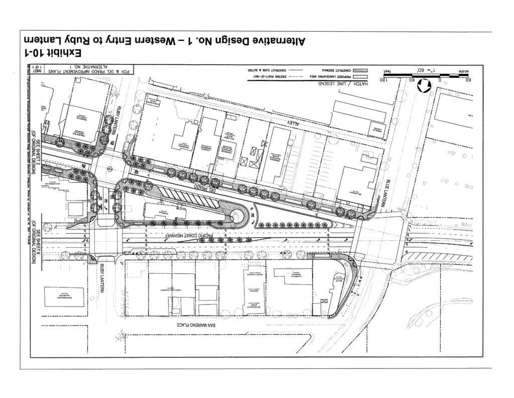
9 Alternative Design No. 1 Similar to the proposed project, Alternative Design No. 1 (refer to Exhibit 10-1) will also provide two-way operations along Pacific oast Highway and Del Prado Avenue. However, a street section along Del Prado Avenue immediately east of Blue Lantern to Ruby Lantern will provide only one-way operation east to west between Blue Lantern and Ruby Lantern (i.e., key study intersection No. 12). The proposed traffic signal for key study intersection No. 12 (i.e. at Del Prado Avenue and Pacific oast Highway) will be eliminated. Westbound Del Prado traffic would jog right to PH at Ruby Lantern and then be required to make a left turn onto PH from Ruby Lantern to process west (up coast). Exhibit 10-1 illustrates the improvement plan for the Alternative Design. Land Use Land use impacts with the Alternative Design would be similar as the proposed project. In general, the improvements would be consistent with the long-range goals, policies and objectives articulated in the relevant elements of the Dana Point General Plan. This alternative would also allow for improved pedestrian access, parking, and safety. Any additional acquisition/easements that would be required to implement the improvements for this alternative would occur within the adopted right-of-way and setback areas for the two roadways and would not significantly affect either existing or future development within the Dana Point Town enter. Private property access issues on Del Prado remain essentially the same as the proposed project, although private property visibility would be confined to one-way traffic between Ruby Lantern and Blue Lantern, resulting in a land use impact. These potential impacts would be similar to the proposed project. No significant land use impacts would occur as a result of implementing the Alternative Design. Traffic and irculation Implementation of the alternative design would retain most of the features of the proposed alternative with the exception of the westbound Del Prado traffic between Ruby Lantern and Blue Lantern. However, there are adverse impacts, as discussed below. Peak Hour Intersection apacity Analysis 2015 Alternative Design No. 1 Traffic onditions Peak hour deficiencies for the Alternative Design No. 1 forecast for 2015 are reflected in Table As indicated in the table, traffic impacts anticipated as a result of this alternative are the same as identified for the proposed project. Although some changes to the levels of service may occur, all of the key study intersections are forecast to operate at acceptable levels of service. Dana Point, A 10-9
10
11 Table 10-5 Year 2015 Peak Hour Intersection apacity Analysis Alternative Design No. 1 Key Study Intersection Blue Lantern/Pacific oast Highway Ruby Lantern/Pacific oast Highway Amber Lantern/Pacific oast Highway Violet Lantern/Pacific oast Highway Golden Lantern/Pacific oast Highway opper Lantern/Pacific oast Highway rystal Lantern/Pacific oast Highway Ruby Lantern/Del Prado Avenue Amber Lantern/Del Prado Avenue Violet Lantern/Del Prado Avenue Golden Lantern/Del Prado Avenue Del Prado Avenue (West)/Pacific oast Highway 1 BOLD Unacceptable LOS Time Period Minimum LOS IU/HM LOS A A A A A A A B B D A B D A B 8.5 s/v A 9.7 s/v A 9.7 s/v A 11.1 s/v B 9.5 s/v A 11.6 s/v B A A 9.6 s/v A 9.3 s/v A 1 This key study intersection would only exist with the proposed project. SOURE: Linscott, Law & Greenspan, Inc. (August 2010) 2035 Alternative Design No. 1 Traffic onditions The 2035 traffic conditions for this alternative are summarized in Table Similar to the 2015 traffic conditions, implementation of this alternative would not result in any significant impacts to the levels of service at the key study intersections. All of the intersections are forecast to operate at acceptable levels of service Dana Point, A 10-11
12 Table 10-6 Year 2035 Peak Hour Intersection apacity Analysis Alternative Design No. 1 Key Study Intersection Blue Lantern/Pacific oast Highway Ruby Lantern/Pacific oast Highway Amber Lantern/Pacific oast Highway Violet Lantern/Pacific oast Highway Golden Lantern/Pacific oast Highway opper Lantern/Pacific oast Highway rystal Lantern/Pacific oast Highway Ruby Lantern/Del Prado Avenue Amber Lantern/Del Prado Avenue Violet Lantern/Del Prado Avenue Golden Lantern/Del Prado Avenue Del Prado Avenue (West)/Pacific oast Highway 1 BOLD Unacceptable LOS Time Period Minimum LOS IU/HM LOS A A A A A B A B D A B D B s/v A 10.2 s/v B 10.2s/v B 12.0 s/v B 9.9 s/v A 12.7 s/v B A A 9.7 s/v A 9.2 s/v A 1 This key study intersection would only exist with the proposed project. SOURE: Linscott, Law & Greenspan, Inc. (August 2010) As previously indicated for the 2015 traffic conditions, no significant impacts to the 12 key study intersections would occur as a result of Alternative Design No. 1. Operations Analysis In addition to the IU analysis methodology employed to evaluate the Alternative Design, the 12 key study intersections were also evaluated utilizing the HM methodology. The results of the HM analysis for this alternative are presented below. Dana Point, A 10-12
13 2015 Alternative Design No. 1 Traffic onditions Table 10-7 summarizes the Year 2015 Alternative Design traffic conditions. As indicated in the table, no significant traffic impacts would occur as a result of implementing this alternative; all of the key study intersections are forecast to operate at acceptable levels of service. Table 10-7 Year 2015 Peak Hour Intersection apacity Analysis (HM Methodology) Alternative Design No. 1 Key Study Intersection Blue Lantern/Pacific oast Highway Ruby Lantern/Pacific oast Highway Amber Lantern/Pacific oast Highway Violet Lantern/Pacific oast Highway Golden Lantern/Pacific oast Highway opper Lantern/Pacific oast Highway rystal Lantern/Pacific oast Highway Ruby Lantern/Del Prado Avenue Amber Lantern/Del Prado Avenue Violet Lantern/Del Prado Avenue Golden Lantern/Del Prado Avenue Del Prado Avenue (West)/Pacific oast Highway 2 BOLD Unacceptable LOS Time Period Minimum LOS HM LOS 9.2 s/v A 13.4 s/v B 6.6 s/v A 6.4 s/v A 10.7 s/v B s/v B 4.6 s/v A 18.6 s/v B 27.4 s/v 31.0 s/v D 12.5 s/v B 13.2 s/v B D 7.2 s/v A 7.6 s/v A 8.5 s/v A 9.7 s/v A 9.7 s/v A 11.1 s/v B 9.5 s/v A 11.6 s/v B 18.8 s/v B 28.0 s/v 9.6 s/v A 9.3 s/v A 1 This key study intersection would only exist with the proposed project. SOURE: Linscott, Law & Greenspan, Inc. (August 2010) 2035 Alternative Design No. 1 Traffic onditions The analysis of the 2035 Alternative Design traffic conditions revealed that the addition of ambient growth traffic and related projects traffic will not result in unacceptable service levels at any of the key study intersections. Table 10-8 summarizes the results of the 2035 Alternative Design No. 1 peak hour intersection capacity analysis based on the HM methodology. Dana Point, A 10-13
14 Table 10-8 Year 2035 Peak Hour Intersection apacity Analysis (HM Methodology) Alternative Design No. 1 Key Study Intersection Blue Lantern/Pacific oast Highway Ruby Lantern/Pacific oast Highway Amber Lantern/Pacific oast Highway Violet Lantern/Pacific oast Highway Golden Lantern/Pacific oast Highway opper Lantern/Pacific oast Highway rystal Lantern/Pacific oast Highway Ruby Lantern/Del Prado Avenue Amber Lantern/Del Prado Avenue Violet Lantern/Del Prado Avenue Golden Lantern/Del Prado Avenue Del Prado Avenue (West)/Pacific oast Highway 1 BOLD Unacceptable LOS Time Period Minimum LOS HM LOS 9.1 s/v A 13.6 s/v B 7.1 s/v A 7.2 s/v A 11.9 s/v B 13.4 s/v B 6.1 s/v A 34.9 s/v 27.8 s/v 34.9 s/v D 10.8 s/v B 14.2 s/v B D 8.3 s/v A 9.5 s/v A 8.7 s/v A 10.2 s/v B 10.2 s/v B 12.0 s/v B 9.9 s/v A 12.7 s/v B 19.3 s/v B 29.2 s/v 9.7 s/v A 9.2 s/v A 1 This key study intersection would only exist with the proposed project. SOURE: Linscott, Law & Greenspan, Inc. (August 2010) As indicated above, some differences would be anticipated in the delay and resulting levels of services; however, similar to the proposed project, Alternative Design No. 1 would not result in any significant adverse intersection operating conditions; all of the key study intersection are anticipated to operate at acceptable levels of service. Queuing Analysis Based on the queuing analysis conducted for the Alternative Design (refer to Section 9.4 in Appendix, Traffic Impact Analysis), adequate turn pocket storage would not be provided at the Blue Lantern/Pacific oast Highway and Ruby Lantern/Pacific oast Highway intersections in both 2015 and However, all of the deficient turn pockets can be modified to accommodate year th percentile queues, except for the shared northbound left/through/right lane at the Ruby Lantern/Pacific oast Highway location. The available storage for this location cannot be increased, which would cause vehicles to Dana Point, A 10-14
15 queue back onto Del Prado Avenue. As a result, this potential adverse impact would be significant and unavoidable in the Alternative Design proposal. The northbound left-turn lane and the northbound right-turn lane at the Blue Lantern/Pacific oast Highway intersection must be restriped to provide 100 feet and 80 feet of storage, respectively, to accommodate Year 2015 traffic volumes. In order to accommodate 2035 traffic volumes, these lanes must be restriped to provide 105 and 85 feet of storage, respectively. These improvements can be accomplished through minor striping modifications along Blue Lantern. Air Quality Air quality impacts associated with Alternative Design No. 1 would be virtually the same as the proposed project. Because the construction activities, equipment usage, and duration of the construction would be the same or similar, the short-term construction-related emissions would also be the same as estimated for the proposed project. Based on those generalized parameters, the construction activity emissions for this alternative, as with the proposed project, would be substantially below the SAQMD thresholds, as reflected in Table (refer to Section 4.3 Air Quality). In addition, the construction emissions associated with the Alternative Design would also not exceed the LSTs developed for the project as reflected in Table As a result, no significant construction-related air quality impacts would occur. Finally, like the proposed project, this alternative would not result in new development that would generate traffic and mobile-source emissions. Rather, future traffic volumes would result from buildout occurring in the region. The one-hour threshold of 20 ppm of O would not be exceeded at any of the key study area intersections because the background concentration is very low (i.e., 2.0 ppm) and the incremental increase associated with future traffic within the study area would contribute a maximum of 1.3 ppm based on the proposed project. However, the O concentrations generated as a result of the Alternative Design would be similar to those occurring from the proposed project; therefore, the O concentrations would not exceed the threshold. No significant impacts are anticipated. limate hange/greenhouse Gas Emissions As with air quality, GHG emissions occurring as a result of the Alternative Design would be the same or similar to those generated by the proposed project and would be limited to the construction phase only. Because the construction activities, equipment usage, and duration of the construction would be similar to those necessary to implement the proposed project, this alternative would generate virtually the same amount of O 2 e as estimated for the proposed project. As indicated in Table 4.4-1, the Alternative Design would not exceed the established threshold for GHG. In addition, because the proposed project does not include development, it would not, therefore, result in additional VMT or other features that would create a demand for energy resources. As a result, no project-related GHG project-related GHG emissions will occur. There are no substantial long-term GHG implications associated with project implementation. Noise The project alternative is similar to the proposed project as it will provide two-way operations along PH and Del Prado Avenue. However, a section along Del Prado Avenue immediately east of Street of the Blue Lantern will have one-way eastbound operation (i.e. between Street of the Blue Lantern and Del Prado Avenue). The proposed traffic signal for the intersection at Del Prado and Golden Lantern would not be built. The traffic noise levels along the project roadways for this alternative were calculated and are shown in Table Dana Point, A 10-15
16 Table 10-9 Traffic Noise Impact Analysis Alternative Design No. 1 (dba NEL at 50 feet from Roadway enterline) Roadway Segment Existing 2015 w/o Project 2015 w/ Project 2035 w/o Project 2035 w/ Project Pacific oast Highway West of Blue Lantern Blue Lantern to Del Prado Avenue Del Prado Avenue to Ruby Lantern Ruby Lantern to Amber Lantern Amber Lantern to Violet Lantern Violet Lantern to Golden Lantern Golden Lantern to opper Lantern opper Lantern to rystal Lantern rystal Lantern to Del Obispo East of Del Obispo N/A 72.4 N/A Del Prado Avenue Blue Lantern to Ruby Lantern Ruby Lantern to Amber Lantern Amber Lantern to Violet Lantern Violet Lantern to Old Golden Lantern Old Golden Lantern to Golden Lantern Golden Lantern to Pacific oast Highway Alley Blue Lantern to Ruby Lantern Ruby Lantern to Amber Lantern Amber Lantern to Violet Lantern Violet Lantern to Old Golden Lantern Blue Lantern North of Pacific oast Highway Pacific oast Highway to Alley South of Alley Ruby Lantern North of Pacific oast Highway Pacific oast Highway to Del Prado Avenue Del Prado Avenue to Alley South of Alley Amber Lantern North of Pacific oast Highway Pacific oast Highway to Del Prado Avenue Del Prado Avenue to Alley South of Alley Violet Lantern North of Pacific oast Highway Pacific oast Highway to Del Prado Avenue Del Prado Avenue to Alley South of Alley Old Golden Lantern Del Prado Avenue to Alley Dana Point, A 10-16
17 Roadway Segment Existing 2015 w/o Project 2015 w/ Project 2035 w/o Project 2035 w/ Project South of Alley Golden Lantern North of Pacific oast Highway Pacific oast Highway to Del Prado Avenue South of Del Prado Avenue opper Lantern North of Pacific oast Highway rystal Lantern North of Pacific oast Highway Del Obispo Street North of Pacific oast Highway N/A 65.9 N/A Dana Point Harbor Drive North of Pacific oast Highway N/A 67.9 N/A SOURE: Giroux & Associates (August 2010) As seen in Table 10-10, implementation of the Alternative Design would result in 4 roadway segments exceeding the significance threshold of +3 db, whereas the proposed Project would exceed the threshold along only 2 roadway segments. However, as with the project as proposed, many roadways are expected to experience a decrease in traffic noise related to traffic volume. Although the exact magnitude of the traffic noise increases and decreases related to volume are slightly altered with the Design Alternative, there is no significant difference from the Project as proposed. Table Traffic Noise Impact Analysis Alternative Design and umulative Project (dba NEL at 50 Feet from enterline) 2015 Alternative Design 2035 Alternative Design umulative Impact 1 Roadway Segment Pacific oast Highway West of Blue Lantern Blue Lantern to Del Prado Avenue Del Prado Avenue to Ruby Lantern Ruby Lantern to Amber Lantern Amber Lantern to Violet Lantern Violet Lantern to Golden Lantern Golden Lantern to opper Lantern opper Lantern to rystal Lantern rystal Lantern to Del Obispo East of Del Obispo N/A N/A N/A Del Prado Avenue Blue Lantern to Ruby Lantern Ruby Lantern to Amber Lantern Amber Lantern to Violet Lantern Violet Lantern to Old Golden Lantern Old Golden Lantern to Golden Lantern Dana Point, A 10-17
18 2015 Alternative Design 2035 Alternative Design umulative Impact 1 Roadway Segment Golden Lantern to Pacific oast Highway Alley Blue Lantern to Ruby Lantern Ruby Lantern to Amber Lantern Amber Lantern to Violet Lantern Violet Lantern to Old Golden Lantern Blue Lantern North of Pacific oast Highway Pacific oast Highway to Alley South of Alley Ruby Lantern North of Pacific oast Highway Pacific oast Highway to Del Prado Avenue Del Prado Avenue to Alley South of Alley Amber Lantern North of Pacific oast Highway Pacific oast Highway to Del Prado Avenue Del Prado Avenue to Alley South of Alley Violet Lantern North of Pacific oast Highway Pacific oast Highway to Del Prado Avenue Del Prado Avenue to Alley South of Alley Old Golden Lantern Del Prado Avenue to Alley South of Alley Golden Lantern North of Pacific oast Highway Pacific oast Highway to Del Prado Avenue South of Del Prado Avenue opper Lantern North of Pacific oast Highway rystal Lantern North of Pacific oast Highway Del Obispo Street North of Pacific oast Highway N/A N/A N/A Dana Point Harbor Drive North of Pacific oast Highway N/A N/A N/A with Project Existing SOURE: Giroux & Associates (August 2010) Dana Point, A 10-18
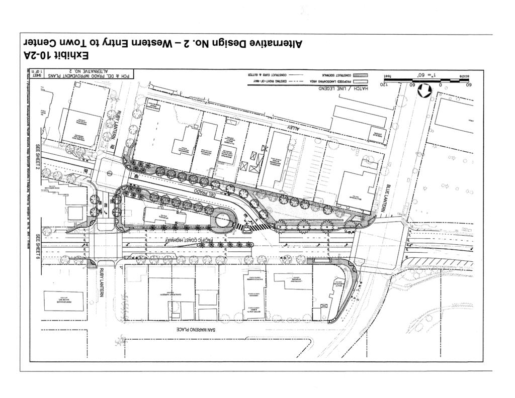
19 Ability to Achieve Project Objectives The Alternative Design 1 would achieve many of the objectives identified by the ity (e.g., street beautification, pedestrian enhancements, improved lighting and drainage, increased parking, water quality improvements, etc.). Elimination/Reduction of Significant Impacts ompared to the proposed project, this alternative would result in the same impacts short-term air quality, noise and greenhouse gas emissions. Long-term traffic impacts would be similar with the exception that queuing impacts could not be mitigated. omparative Merits Although this alternative does achieve many of the project s alternatives, it would not improve overall traffic circulation and safety within the Town enter as desired by the ity and it reduces street visibility for land uses on Del Prado between Ruby Lantern and Blue Lantern. In addition, when compared to the proposed project, a significant and unavoidable long-term queuing impact at one intersection would occur that would not occur with the proposed project Alternative Design No. 2 This alternative would allow for the same proposed circulation adjustments as the proposed project by changing both Pacific oast Highway (PH) and Del Prado from one-way to two-way streets between Blue Lantern and opper Lantern; however, right-of-way improvements on Del Prado between Ruby Lantern and Golden Lantern would not be implemented. PH would consist of four lanes, two in each direction and Del Prado would consist of one lane in each direction. Proposed improvements would include all right-of-way work on PH to facilitate two-way travel flow, which is the same as in the proposed project alternative. Town enter gateways at both ends (Blue Lantern and opper Lantern) would also be the same as the proposed project, with like improvements to both PH and to Del Prado. These gateway street and right-of-way improvements would extend into the Town enter to Ruby Lantern on the up coast (i.e., east) end and Golden Lantern on the down coast (i.e., west) end. Also on Del Prado, the three traffic signals at Ruby Lantern, Amber Lantern and Violet Lantern would be replaced with stop signs. All existing driveways would remain open with the exception of those on Del Prado between Blue Lantern and Ruby Lantern. Exhibit 10-2A through Exhibit 10-2K illustrate Alternative Design No. 2. Land Use Land use impacts with Alternative Design No. 2 would provide two-way traffic on both PH and Del Prado Avenue, similar to the proposed project. In general, the improvements would be consistent with the irculation Element of the Dana Point General Plan. However, this alternative would not fully realize objectives for a pedestrian friendly Del Prado Avenue or meet Town enter Plan policies for landscaping, water quality, noise, etc. Similar to the proposed project, any additional acquisition/easements that would be required to implement the improvements for this alternative would occur within the adopted right-ofway and setback areas for the two roadways and would not significantly affect either existing or future development within the Dana Point Town enter. These potential impacts would be similar to the proposed project. No significant land use impacts would occur as a result of implementing the Alternative Design. Dana Point, A 10-19
20
21
22
23
24
25
26
27
28
29
30
31 Traffic and irculation Traffic impacts identified for Alternative Design No. 2 would be similar to those identified for proposed project and presented in Section 4.2 (Traffic and irculation). Specifically, the construction-related impacts would be the same for PH and Del Prado Avenue between Blue Lantern and Ruby Lantern and between Golden Lantern and opper Lantern, necessitating the same level of mitigation to ensure that traffic operations during the construction phases would be maintained and impacts minimized. Longrange traffic impacts would also be similar as reflected in Tables 4.2-2, 4.2-3, and As indicated in that analysis, all of the intersections would operate at acceptable levels of service. Allowing all the driveways to remain open on Del Prado Avenue between Ruby Lantern and Golden Lantern will not meet the pedestrian friendly pathways goal as well as the proposed project. Air Quality As indicated for Alternative Design No. 1, air quality impacts associated with this alternative would also be the same as the proposed project. Because the construction activities, equipment usage, and duration of the construction would be similar, except for the section of Del Prado Avenue between Ruby Lantern and Golden Lantern, the short-term construction-related emissions would be the similar to those estimated for the proposed project, except for a shorter construction period duration. Based on those generalized parameters, the construction activity emissions for this alternative, as with the proposed project, would be substantially below the SAQMD thresholds. In addition, the construction emissions associated with this alternative design would also not exceed the LSTs developed for the project. Therefore, no significant construction-related air quality impacts would occur. Finally, like the proposed project, this alternative would not result in new development that would generate traffic and mobile-source emissions. Rather, future traffic volumes would only result from buildout occurring in the region. The one-hour threshold of 20 ppm of O would not be exceeded at any of the key study area intersections because the background concentration is very low (i.e., 2.0 ppm) and the incremental increase associated with future traffic within the study area would contribute a maximum of 1.3 ppm based on the proposed project. Because the O concentrations generated as a result of this alternative would be similar to those occurring from the proposed project, no significant impacts associated with O concentrations would occur. limate hange/greenhouse Gas Emissions GHG emissions occurring as a result of Alternative Design No. 2 would be somewhat lessened when compared to those generated by the proposed project due to the reduction in work scope between Ruby Lantern and Golden Lantern on Del Prado Avenue, and would be limited to the construction phase only. As indicated for Alternative Design No. 1, the construction activities, equipment usage, and duration of the construction would be somewhat lessened when compared to those necessary to implement the proposed project. Therefore, this alternative would also generate less O 2 e than the amount estimated for the proposed project and would not, therefore, exceed the established threshold for GHG. In addition, because the proposed project does not include development, this alternative design would not, therefore, result in additional VMT or other features that would create a demand for energy resources. As a result, no project-related GHG emissions will occur. There are no substantial long-term GHG implications associated with the implementation of Alternative Design No. 2. Noise Because traffic volumes would be the same as indicated for the proposed project, it is anticipated that potential traffic-related noise impacts along both PH and Del Prado Avenue would also be similar to the proposed project, particularly between opper Lantern and Ruby Lantern. However, not all traffic calming initiatives on Del Prado Avenue (bulb outs/narrower lanes) would be realized so noise reduction benefits would not be as great in comparison with the proposed project. Potential noise impacts would not be significant in either case. Dana Point, A 10-31
32 Ability to Achieve Project Objectives This alternative design would also achieve some of the objectives identified by the ity (e.g., circulation entry beautification), but will not meet all traffic calming benefits, beautification, noise reduction, pedestrian enhancements, improved lighting, and water quality objectives). Similar to the proposed project, implementation of this alternative would not result in intersection deficiencies. Elimination/Reduction of Significant Impacts ompared to the proposed project, this alternative would result in some less than significant impacts on Del Prado Avenue between Ruby Lantern and Golden Lantern (e.g., short-term air quality, noise, greenhouse gas emissions, and traffic impacts), although somewhat reduced with the elimination of all but the stop sign/signal work on Del Prado Avenue between Ruby Lantern and Golden Lantern. omparative Merits Although this alternative does achieve some of the project s objectives, it would not meet many objectives as noted above, and while this alternative may be marginally better as regards less than significant short-term construction impacts, it does not provide the long-term environmental benefits to water quality and noise when compared to the proposed project Summary of Alternatives An EIR is required to identify the environmentally superior alternative among those evaluated from the reasonable range of alternative analyzed. Section (e)(2) of the State EQA Guidelines mandates that in the event... the environmentally superior alternative is the no project alternative, the EIR shall also identify an environmentally superior alternative among the other alternatives. In addition, alternatives identified and evaluated are also intended to achieve project objectives. As indicated in Table 10-11, none of the three alternatives meet the proposed project objectives fully. Implementation of the No Project alternative would eliminate the potential short-term (construction) impacts related to noise, air quality and greenhouse gas emissions anticipated to occur as a result of the proposed project; however, this alternative would result in potentially significant impacts at three traffic intersections that would not occur with the proposed project and would not provide traffic calming, noise or water quality benefits provided by the proposed project. Alternative Design No. 1 is similar to the proposed project and would result in similar impacts when compared to the proposed project; however, this alternative would also result in potentially significant impacts at the same three intersections as the No Project Alternative, an not provide proposed water quality enhancements.. Alternative Design No. 2 lessens the less than significant, short-term construction impacts of traffic, air quality, and greenhouse gas emissions, but does not provide the long-term water quality benefits nor improve the long-term noise reduction benefits to the extent of the proposed project. Dana Point, A 10-32
33 Table omparison of Alternatives PH/Del Prado Street Improvement Project Alternative Environmental Issue No Project Alt. Design No. 1 Alt. Design No. 2 Land Use Traffic and irculation Air Quality 1 o 1 limate hange/greenhouse Gas 1 o 1 Noise + o + Water Quality + o + 1 Less than significant short-term, construction-related impacts only due to reduced construction scope between Ruby Lantern and Golden Lantern on Del Prado Avenue. LEGEND Lesser Impact than the Proposed Project o Same impacts as the Proposed Project + Greater impact than the Proposed Project Dana Point, A 10-33
City of Los Angeles 2010 Bicycle Plan First Year of the First Five-Year Implementation Strategy & Figueroa Streetscape Project Draft EIR
 5.0 ALTERNATIVES California Environmental Quality Act (CEQA) requires that an EIR describe a range of reasonable alternatives to the project or to the location of the project that could feasibly avoid
CHAPTER 2: MODELING METHODOLOGY
 CHAPTER 2: MODELING METHODOLOGY 2.1 PROCESS OVERVIEW The methodology used to forecast future conditions consisted of traditional traffic engineering practices and tools with enhancements to more accurately
Appendix G Analysis of Project Impacts Compared to Existing Conditions
 Appendix G Analysis of Project Impacts Compared to Existing Conditions This page intentionally left blank. Analysis of Project Impacts Compared to Existing Conditions Introduction The analysis scenarios
6. Significant Unavoidable Adverse Impacts
 6. Significant Unavoidable Adverse Impacts The table at the end of Chapter 1, Executive Summary, summarizes the impacts, mitigation measures, and levels of significance before and after mitigation. Although
City of Berkeley. Guidelines for Development of Traffic Impact Reports
 Office of Transportation (OOT) City of Berkeley Guidelines for Development of Traffic Impact Reports Office of Transportation, City of Berkeley 1 1. Overview These guidelines provide a framework to help
Traffic Impact Study Requirements
 [TYPE THE COMPANY NAME] Traffic Impact Study Requirements County of San Mateo Department of Public Works Roadway Services 9/1/2013 I. Introduction The County of San Mateo (County), Department of Public
Woodburn Interchange Project Transportation Technical Report
 Final Report Woodburn Interchange Project Transportation Technical Report Prepared for Oregon Department of Transportation April 212 Prepared by DKS Associates Contents Methodologies... 4 Volume Development...
GUIDE FOR THE PREPARATION OF TRAFFIC IMPACT STUDIES
 GUIDE FOR THE PREPARATION OF TRAFFIC IMPACT STUDIES Adopted by Town Council on November 25, 2008 Prepared By: HNTB Engineering Department Planning Department TABLE OF CONTENTS I. INTRODUCTION... 1 II.
City of Menifee. Public Works Department. Traffic Impact Analysis Guidelines
 Public Works Department Traffic Impact Analysis Guidelines Revised: August 2015 TABLE OF CONTENTS INTRODUCTION... 3 PURPOSE... 3 EXEMPTIONS... 3 SCOPING... 4 METHODOLOGY... 5 STUDY AREA... 6 STUDY SCENARIOS...
BCEO TRAFFIC IMPACT STUDY GUIDELINES
 BCEO TRAFFIC IMPACT STUDY GUIDELINES February 2006 TABLE OF CONTENTS INTRODUCTION..... i TRAFFIC IMPACT STUDY STRUCTURE... 1 WHEN IS A TRAFFIC IMPACT STUDY NEEDED?..... 1 STUDY AREA, SITE PLAN & HORIZON
This comparison is designed to satisfy the requirements of State CEQA Guidelines, Section (d), Evaluation of Alternatives, which state that:
, Evaluation of Alternatives, which state that:") 6.0 Comparison of Proposed Project and Alternatives This chapter summarizes the environmental advantages and disadvantages associated with the Proposed Project and the alternatives. Based upon this discussion,
6.0 Comparison of Proposed Project and Alternatives This chapter summarizes the environmental advantages and disadvantages associated with the Proposed Project and the alternatives. Based upon this discussion,
CITY OF MARIANNA MUNICIPAL DEVELOPMENT DEPARTMENT Post Office Box 936 Marianna, FL (850)
") CITY OF MARIANNA MUNICIPAL DEVELOPMENT DEPARTMENT Post Office Box 936 Marianna, FL 32447 (850) 482-2786 TRANSPORTATION CONCURRENCY ANALYSIS CITY OF MARIANNA CONCURRENCY MANAGEMENT SYSTEM (CMS) This form
CITY OF MARIANNA MUNICIPAL DEVELOPMENT DEPARTMENT Post Office Box 936 Marianna, FL 32447 (850) 482-2786 TRANSPORTATION CONCURRENCY ANALYSIS CITY OF MARIANNA CONCURRENCY MANAGEMENT SYSTEM (CMS) This form
TABLE OF CONTENTS TABLE OF CONTENTS... I APPENDICES... III LIST OF EXHIBITS... V LIST OF TABLES... VII LIST OF ABBREVIATED TERMS...
 Amendment No. 2 to Reclamation Plan 2006-01 Traffic Impact Analysis TABLE OF CONTENTS TABLE OF CONTENTS... I APPENDICES... III LIST OF EXHIBITS... V LIST OF TABLES... VII LIST OF ABBREVIATED TERMS... IX
Future Build Alternative Traffic Forecasts and Level of Service Analysis
 4.2.10 Future Build Alternative Traffic Forecasts and Level of Service Analysis For the five Build Alternatives, study intersections within one mile of potential station locations were analyzed, as it
5.0 ALTERNATIVES 5.1 INTRODUCTION
 5.1 INTRODUCTION The California Environmental Quality Act (CEQA) Guidelines state that an EIR shall describe a range of reasonable alternatives to the Project, or to the location of the Project, which
Article 16 Traffic Impact Analysis
 Article 16 Traffic Impact Analysis Table of Contents... 16-1 Chapter 16.1 Purpose and Intent... 16-2 Chapter 16.2 Applicability... 16-2 Chapter 16.3 Exemptions... 16-2 Chapter 16.4 Trip Generation Data...
TOWN OF MOORESVILLE TRANSPORTATION IMPACT ANALYSIS PROCEDURES MANUAL TOWN OF MOORESVILLE, NORTH CAROLINA
 TOWN OF MOORESVILLE TRANSPORTATION IMPACT ANALYSIS PROCEDURES MANUAL TOWN OF MOORESVILLE, NORTH CAROLINA Effective August 1, 2007 Amended March 4, 2013, December 1, 2014, May 1, 2017 TOWN OF MOORESVILLE,
GUIDELINES FOR TRAFFIC IMPACT ANALYSIS (ZONING PETITIONS)
") GUIDELINES FOR TRAFFIC IMPACT ANALYSIS (ZONING PETITIONS) (A) INTENT This Section is intended to help ensure that new development does not adversely affect the capacity of streets and intersections to
GUIDELINES FOR TRAFFIC IMPACT ANALYSIS (ZONING PETITIONS) (A) INTENT This Section is intended to help ensure that new development does not adversely affect the capacity of streets and intersections to
5.4.1 METHODOLOGY AND PERFORMANCE CRITERIA
 Section 5.4 TRAFFIC 5.4 TRAFFIC This section evaluates the impacts of the proposed project on the local traffic system in the vicinity of the project site. This analysis summarizes the findings of the
ALBION FLATS DEVELOPMENT EXISTING TRAFFIC CONDITIONS AND POTENTIAL IMPACTS
 EXISTING TRAFFIC CONDITIONS AND POTENTIAL IMPACTS FINAL REPORT SEPTEMBER 2010 TABLE OF CONTENTS 1.0 INTRODUCTION 1 2.0 EXISTING TRAFFIC CONDITIONS 2 3.0 FUTURE TRAFFIC CONDITIONS 3 4.0 POTENTIAL IMPACTS
Preliminary Assessment of Interchange Concepts. Seven Corners Task Force March 11, 2014
 Preliminary Assessment of Interchange Concepts Seven Corners Task Force March 11, 2014 Presentation overview Introduction Concept selection and refinement Future volume development and assignment Preliminary
VIII. LAND USE ISSUES
 VIII. LAND USE ISSUES The & Route 57 Land Use and Circulation Study (Land Use Study, Figure 6) was completed for the Town of Clay in November 1999 (Clough, Harbour & Associates). This study investigated
DIVISION I TRAFFIC IMPACT STUDY GUIDELINES ENGINEERING STANDARDS
 CITY OF ALBANY DEPARTMENT OF PUBLIC WORKS DIVISION I TRAFFIC IMPACT STUDY GUIDELINES ENGINEERING STANDARDS Prepared By PUBLIC WORKS DEPARTMENT ALBANY, OREGON 97321 Telephone: (541) 917-7676 TABLE OF CONTENTS
PROJECT DESCRIPTION...
 TABLE OF CONTENTS Volume I Chapter Page 1. INTRODUCTION... 1-1 1.1 Introduction... 1-1 1.2 Project Description... 1-1 1.3 Purpose of the EIR... 1-2 1.4 EIR Process... 1-3 1.5 Scope of the Draft EIR...
5.0 ALTERNATIVE VARIATIONS
 5.0 ALTERNATIVE VARIATIONS 5.1 INTRODUCTION The Draft EIR for the Beverly Hilton Revitalization Plan evaluated five alternatives to the project, pursuant to Section 15126.6 of the California Environmental
Traffic Impact Analysis Guidelines. Town of Queen Creek
 Traffic Impact Analysis Guidelines Town of Queen Creek January 2016 1. INTRODUCTION The purpose of this document is to outline the procedures and requirements for preparing a Transportation Impact Analysis
CITY OF CLOVIS Traffic Impact Study Guidelines
 CITY OF CLOVIS Traffic Impact Study Guidelines CLOVIS, A WAY OF LIFE Approved August 25, 2014 City Council Resolution 2014-79 Prepared by City of Clovis Engineering Division Steve White, City Engineer
SECTION 5: ALTERNATIVES TO THE PROPOSED PROJECT
 City of American Canyon Broadway District Specific Plan Alternatives to the Proposed Project SECTION 5: ALTERNATIVES TO THE PROPOSED PROJECT 5.1 Introduction In accordance with CEQA Guidelines Section
TRANSPORTATION IMPACT ANALYSISGUIDELINES
 TRANSPORTATION IMPACT ANALYSISGUIDELINES ADOPTED OCTOBER2014 SANTACLARAVALLEYTRANSPORTATION AUTHORITY CONGESTION MANAGEMENTPROGRAM CONGESTION MANAGEMENT PROGRAM TRANSPORTATION IMPACT ANALYSIS GUIDELINES
Draft Environmental Impact City of Daly City General Plan Update. Sacramento, California, May
 The EIR must examine the potential growth-inducing impacts of the proposed General Plan. More specifically, CEQA Guidelines require that the EIR discuss the ways in which the proposed project could foster
Environmental Consequences and Mitigation
 Chapter 4 Environmental Consequences and Mitigation 4.1 Introduction This chapter provides a detailed description of the impacts (and indirect impacts where applicable) associated with the alternatives
MULTIMODAL TRANSPORTATION IMPACT STUDY GUIDELINES
 MULTIMODAL TRANSPORTATION IMPACT STUDY GUIDELINES 1 st Edition City of San Luis Obispo 2035 Circulation Element 1 Table of Contents Introduction... 2 Process... 2 When Impact Studies Are Required... 3
MEMORANDUM: INITIAL CONCEPTS SUMMARY
 MEMORANDUM: INITIAL CONCEPTS SUMMARY INTRODUCTION This memo presents a summary of initial concepts that have been identified as development of the project study has progressed, along with a recommendations
Patrick Prescott, Community Development Director By: David L. Kriske, Assistant Community Development Director
 DATE: April 26, 2016 TO: FROM: Ron Davis, Interim City Manager Patrick Prescott, Community Development Director By: David L. Kriske, Assistant Community Development Director SUBJECT: Modification of two
City of Lake Forest SERRANO SUMMIT (IRWD SITE) Traffic Study. April 2010
 Traffic Study. April 2010") G: Traffic Study City of Lake Forest SERRANO SUMMIT (IRWD SITE) Traffic Study April 2010 Draft City of Lake Forest SERRANO SUMMIT (IRWD SITE) Traffic Study Prepared by: Austin-Foust Associates, Inc. 2223
G: Traffic Study City of Lake Forest SERRANO SUMMIT (IRWD SITE) Traffic Study April 2010 Draft City of Lake Forest SERRANO SUMMIT (IRWD SITE) Traffic Study Prepared by: Austin-Foust Associates, Inc. 2223
ERRATA TO THE FINAL EIR
 DRAFT EIR ERRATA TO THE FINAL EIR The following paragraphs in Section 6.0, Alternatives, are edited as follows: The following discussion evaluates alternatives to the Proposed Project and examines the
CITY OF VALLEJO PUBLIC WORKS DEPARTMENT TRAFFIC IMPACT Analysis/Study GUIDELINES
 The City Engineer, under the authority of the Public Works Director and recommendations from the Traffic Engineer, will make the final decision on the need for a traffic study. The purpose of the traffic
Menlo Park Planning Commission Draft EIR Public Hearing June 20, 2016
 Menlo Park Planning Commission Draft EIR Public Hearing June 20, 2016 1 Purpose of Hearing Introduction to EIR Project Team Project Overview Draft Environmental Impact Report (EIR) Impacts and Mitigation
CITY OF LA MESA MIXED-USE OVERLAY ZONE PROJECT La Mesa, California August 15, 2007 Revised January 16, 2008
 TRAFFIC IMPACT STUDY CITY OF LA MESA MIXED-USE OVERLAY ZONE PROJECT La Mesa, California August 15, 2007 Revised January 16, 2008 Prepared for: DUDEK & ASSOCIATES 605 Third Street Encinitas, California
Dated: January 2015 TRANSPORTATION IMPACT STUDY GUIDELINES
 Dated: January 2015 TRANSPORTATION IMPACT STUDY GUIDELINES TABLE OF CONTENTS 1.0 Introduction.. 2 1.1 Transportation Impact Study...... 2 1.2 Need and Justification... 2 1.3 Purpose of Guidelines... 2
County of El Dorado. El Dorado Hills Apartments Project Draft Environmental Impact Report. SCH No Prepared For: Prepared by:
 County of El Dorado El Dorado Hills Apartments Project Draft Environmental Impact Report SCH No. 2017042017 Prepared by: 505 14th Street, Suite 1230 Oakland, California 94612 Prepared For: County of El
5.7 Traffic 5.7 TRAFFIC Affected Environment
 5.7 TRAFFIC 5.7.1 Affected Environment Regional Transportation System The main vehicular traffic access routes into SBMR are via H-2 from the Ewa/Honolulu area, Kamehameha Highway and Kunia Road from the
6. Significant Unavoidable Adverse Impacts
 Chapter 1, Executive Summary, contains Table 1-1, which summarizes the impacts; Programs, Plans and Policies (PPP); Project Design Features (PDF); mitigation measures; and levels of significance before
I-70 East ROD 1: Phase 1 (Central 70 Project) Air Quality Conformity Technical Report
 Air Quality Conformity Technical Report") I-70 East ROD 1: Air Quality Conformity Technical Report January 2017 I-70 East ROD 1: Air Quality Conformity Technical Report TABLE OF CONTENTS Chapter Page 1 PURPOSE OF THIS REPORT... 1 2 PROJECT DESCRIPTION...
I-70 East ROD 1: Air Quality Conformity Technical Report January 2017 I-70 East ROD 1: Air Quality Conformity Technical Report TABLE OF CONTENTS Chapter Page 1 PURPOSE OF THIS REPORT... 1 2 PROJECT DESCRIPTION...
6.2.2 Environmental Consequences and Mitigation Measures
 6.2 6.2.1 Introduction The existing conditions, regulatory setting, and methods of analysis for transportation under CEQA are described in Chapter 3, NEPA and CEQA Analysis. Impacts that would result from
City of Fountain Valley. Fountain Valley Crossings Specific Plan Project: Draft EIR Public Hearing. January 25, 2017
 City of Fountain Valley Fountain Valley Crossings Specific Plan Project: Draft EIR Public Hearing January 25, 2017 PURPOSE OF PUBLIC HEARING Receive comments from members of the public, organizations and
CHAPTER 5 PARALLEL PARKWAY CORRIDOR IMPROVEMENTS
 HPTER 5 PRLLEL PRKWY ORRIDOR IMPROVEMENTS nother key area within the Village West study area is the Parallel Parkway corridor. This chapter focuses on the segment of Parallel Parkway between 106 th Street
RESOLUTION NO:
 RESOLUTION NO: 11-031 A RESOLUTION OF THE CITY COUNCIL OF THE CITY OF PASO ROBLES CERTIFYING THE FINAL ENVIRONMENTAL IMPACT REPORT FOR THE 2011 CIRCULATION ELEMENT OF THE GENERAL PLAN AND ADOPTING FINDINGS,
4 Project Alternatives
 CHAPTER 4 PROJECT ALTERNATIVES 4.1 Introduction This section summarizes The Villages Escondido Country Club Project (Project) to allow for an evaluation of its comparative merit with a range of reasonable
Traffic Impact Study Guidelines. City of Guelph
 Traffic Impact Study Guidelines City of Guelph April 2016 Engineering and Capital Infrastructure Services Infrastructure, Development & Enterprise 1 Carden Street Guelph, Ontario Canada N1H 3A1 Page 1
6 ALTERNATIVES 6.1 INTRODUCTION
 6 ALTERNATIVES 6.1 INTRODUCTION Environmental impact reports (EIRs) are required to consider alternatives to the project that are capable of reducing or avoiding significant environmental impacts. Section
Broadway Grade Separation Study. Palo Alto Rail Committee Meeting November 29, 2017
 Palo Alto Rail Committee Meeting November 29, 2017 Slide 1 Project Area Millbrae Station City Limits Existing Railroad Crossing at Broadway Caltrain Operational Constraint Major Constraints Millbrae Station
Appendix D1 Screening Analysis
 Appendix D Screening Analysis of Additional Resource Areas for Consideration in the CS SEIR due to Assumed Incremental Increase in Terminal Throughput under the Revised Project Appendix D1 Screening Analysis
Appendix F 2008 Travel Demand Modeling
 Appendix F 2008 Travel Demand Modeling TRAVEL DEMAND MODELING Purpose: The Jackson/Teton County Comprehensive Plan Update is revisiting land use and transportation planning policies to ensure they can
The Folded Interchange: An Unconventional Design for the Reconstruction of Cloverleaf Interchanges
 The Folded Interchange: An Unconventional Design for the Reconstruction of Cloverleaf Interchanges I. ABSTRACT Keith A. Riniker, PE, PTOE This paper presents the Folded Interchange design and compares
PARKMERCED PROJECT EIR ERRATA
 PARKMERCED PROJECT EIR ERRATA This section presents additional staff initiated text changes for the Parkmerced Project Draft Environmental Impact Report. These EIR text changes reflect revisions that have
SECTION 5: ALTERNATIVES TO THE PROPOSED PROJECT
 SECTION 5: ALTERNATIVES TO THE PROPOSED PROJECT 5.1 - Introduction In accordance with CEQA Guidelines Section 15126.6, this Draft Subsequent Environmental Impact Report (DSEIR) contains a comparative impact
4. ENVIRONMENTAL IMPACT ANALYSIS 11. TRANSPORTATION AND CIRCULATION 1. TRAFFIC
 4. EVIROMETAL IMPACT AALYSIS 11. TRASPORTATIO AD CIRCULATIO 1. TRAFFIC 1. ITRODUCTIO The following section summarizes the information provided in the Traffic Impact Study, SMC Malibu Satellite Campus Project,
Final Air Quality Report
 Florida Department of TRANSPORTATION Final Air Quality Report PD&E Study From East of Babcock Street (SR 507) to US 1 Brevard County, Florida Financial Project ID: 430136-1-22-01 ETDM Project Number: 13026
SECTION VII TRAFFIC IMPACT ANALYSIS GUIDELINES
 SECTION VII TRAFFIC IMPACT ANALYSIS GUIDELINES A. GENERAL Traffic Impact Analyses (TIAs) are tools that have historically been utilized to evaluate the interaction between existing transportation infrastructures
III. ENVIRONMENTAL IMPACT ANALYSIS F. TRAFFIC
 III. ENVIRONMENTAL IMPACT ANALYSIS F. TRAFFIC This section summarizes the traffic impact analysis prepared by Kaku Associates in May, 2002. Detailed calculation worksheets are contained in Appendix D to
Placerville, a Unique Historical Past Forging into a Golden Future
 Placerville, a Unique Historical Past Forging into a Golden Future City Manager s Report June 24, 2014 City Council Meeting Prepared by: Nathan Stong, City Engineer Item #: Subject: Adopt a Resolution:
5.0 PROJECT ALTERNATIVES
 5.0 ALTERNATIVES 5.1 INTRODUCTION GENERAL CEQA REQUIREMENTS California Environmental Quality Act (CEQA) Guidelines Section 15126.6(a) states an EIR shall describe a range of reasonable alternatives to
Therefore, each of the alternatives to the Specific Plan addressed in this EIR were selected based on the following factors:
 CHAPTER 5 Alternatives 5.1 Criteria for Selecting Alternatives CEQA requires that the EIR compare the effects of a reasonable range of alternatives to the effects of the project. The alternatives selected
New Transportation Performance Measures for Transportation Analysis and Thresholds for CEQA
 New Transportation Performance Measures for Transportation Analysis and Thresholds for CEQA Transportation Advisory Commission September 11, 2014 Transportation Performance Measures Overview of OPR s Draft
TRAFFIC STUDY GUIDELINES
 TRAFFIC STUDY GUIDELINES December 2013 The scope of the traffic impact analysis (TIA) should follow these guidelines and the requirements of VMC 11.80.130 and VMC 11.70, transportation concurrency (attached
TRANSPORTATION IMPACT ANALYSIS GUIDELINES
 TRANSPORTATION IMPACT ANALYSIS GUIDELINES SANTA CLARA COUNTY TRANSPORTATION AUTHORITY CONGESTION MANAGEMENT PROGRAM ADOPTED MARCH 2009 TABLE OF CONTENTS PART I - STATUTE AND AUTHORITY...1 CHAPTER 1. CMP
APPENDIX B. Public Works and Development Engineering Services Division Guidelines for Traffic Impact Studies
 APPENDIX B Public Works and Development Engineering Services Division Guidelines for Traffic Impact Studies Revised December 7, 2010 via Resolution # 100991 Reformatted March 18, 2011 TABLE OF CONTENTS
1.0 Introduction Traffic Study Overview Study Area Overview of Senate Bill
 TABLE OF CONTENTS SECTION PAGE 1.0 Introduction... 1 1.1 Traffic Study Overview... 1 1.2 Study Area... 3 1.3 Overview of Senate Bill 743... 4 2.0 Project Description... 5 2.1 Site Location... 5 2.2 Existing
2 ENVIRONMENTAL REVIEW AND THRESHOLDS OF SIGNIFICANCE
 2 ENVIRONMENTAL REVIEW AND THRESHOLDS OF SIGNIFICANCE 2.1 ENVIRONMENTAL REVIEW PROCESS The California Environmental Quality Act (CEQA) requires that public agencies (e.g., local, county, regional, and
7.1 Introduction. 7.2 Environmental Assessment Zoning and Land Use. Affected Environment
 Chapter 7 7.1 Introduction Environmental Assessment This section reviews the relationship of the proposed action to a series of environmental topics, federal legislation, and executive orders that address
TABLE OF CONTENTS ES EXECUTIVE SUMMARY 1.0 INTRODUCTION 2.0 PROJECT DESCRIPTION 3.0 ENVIRONMENTAL ANALYSIS
 ES EXECUTIVE SUMMARY ES1 ES2 ES3 ES4 ES5 Purpose and Scope of the Environmental Impact Report... ES-1 Project Summary... ES-1 Project Alternatives Summary... ES-1 Areas of Controversy/Issues to be Resolved...
LAS VEGAS STREET RAILROAD CROSSING RR/PUC CONNECTION AND PRELIMINARY DESIGN
 LAS VEGAS STREET RAILROAD CROSSING RR/PUC CONNECTION AND PRELIMINARY DESIGN Prepared for: City of Colorado Springs Prepared by: Felsburg Holt & Ullevig 508 South Tejon Street Colorado Springs, CO 80903
APPENDIX I. Traffic Study
 APPENDIX I Traffic Study May 24, 2017 Mr. Tom Dodson Tom Dodson & Associates 2150 North Arrowhead Avenue San Bernardino, CA 92405 SUBJECT: LIBERTY LANE APARTMENTS FOCUSED TRAFFIC ASSESSMENT Dear Mr. Tom
CITY OF TEHACHAPI GENERAL PLAN Draft Environmental Impact Report
 City of Tehachapi CITY OF TEHACHAPI GENERAL PLAN Draft Environmental Impact Report SCH No. 2009101084 Prepared for: City of Tehachapi Community Development Department 115 South Robinson Street Tehachapi,
TRAFFIC IMPACT ASSESSMENT GUIDELINE
 Ministry of Public Infrastructure & Land Transport [Land Transport Division] TRAFFIC IMPACT ASSESSMENT GUIDELINE Traffic Management and Road Safety Unit Samlo Tower Aurelle Feillafe Street Port Louis Tel:
CHAPTER 8 TRANSPORTATION ELEMENT
 CHAPTER 8 TRANSPORTATION ELEMENT Section 8.01 Purpose: The purpose of this Chapter (element) is to establish the desired and projected transportation system within Niceville and to plan for future motorized
OTHER CEQA CONSIDERATIONS
 Chapter 5 OTHER CEQA CONSIDERATIONS CEQA Guidelines Section 15128 requires that an EIR disclose the reasons why various possible environmental effects of a proposed project are found not to be significant
5 ALTERNATIVES TO THE PROPOSED PROJECT
 5 ALTERNATIVES TO THE PROPOSED PROJECT 5.1 INTRODUCTION In accordance with Section 15126.6(a) of the State California Environmental Quality Act (CEQA) Guidelines, an environmental impact report (EIR) must
6.1 INTRODUCTION 6.2 REGULATORY FRAMEWORK NATIONAL AMBIENT AIR QUALITY STANDARDS COMPLIANCE STATUS TRANSPORTATION CONFORMITY
 Chapter 6 Air Quality 6.1 INTRODUCTION This chapter presents a project-level analysis of the potential for air quality impacts that could result from mobile and stationary sources of air emissions generated
City of Malibu. Whole Foods and the Park Shopping Center Draft Environmental Impact Report Volume I. Prepared For: Prepared by:
 City of Malibu Whole Foods and the Park Shopping Center Draft Environmental Impact Report Volume I Prepared For: Prepared by: I M PA C T S C I E N C E S, I N C. 638 East Colorado Blvd, Suite 301 Pasadena,
Transportation and Works Department The Regional Municipality of York Yonge Street Newmarket, Ontario L3Y 6Z1
 TRANSPORTATION IMPACT STUDY (TIS) GUIDELINES FOR DEVELOPMENT APPLICATIONS Transportation and Works Department The Regional Municipality of York 17250 Yonge Street Newmarket, Ontario L3Y 6Z1 August, 2007
6. Cumulative Impacts
 6.1 OVERVIEW Section 15355 of the California Environmental Quality Act (CEQA) Guidelines defines cumulative impacts as: "...two or more individual effects which when considered together, are considerable
UPTOWN TRAFFIC IMPACT ANALYSIS
 UPTOWN TRAFFIC IMPACT ANALYSIS This memorandum summarizes the results of the traffic analysis conducted to evaluate the traffic operations of the intersections along Post Oak Boulevard within Uptown Houston
PROPOSED CALIFORNIA ENVIRONMENTAL QUALITY ACT (CEQA) TRANSPORTATION SECTION UPDATE
 TRANSPORTATION SECTION UPDATE") DRAFT DOCUMENT CITY OF LOS ANGELES PROPOSED CALIFORNIA ENVIRONMENTAL QUALITY ACT (CEQA) TRANSPORTATION SECTION UPDATE Prepared by: Departments of City Planning (DCP) and (LADOT) 3.xx 1 DRAFT 2018 LOS ANGELES
DRAFT DOCUMENT CITY OF LOS ANGELES PROPOSED CALIFORNIA ENVIRONMENTAL QUALITY ACT (CEQA) TRANSPORTATION SECTION UPDATE Prepared by: Departments of City Planning (DCP) and (LADOT) 3.xx 1 DRAFT 2018 LOS ANGELES
M D 355 [FR E D E R IC K R O A D] OVER
![M D 355 [FR E D E R IC K R O A D] OVER](/thumbs/79/79553721.jpg "M D 355 [FR E D E R IC K R O A D] OVER") M D 355 [FR E D E R IC K R O A D] OVER LITTLE BENNETT CREEK MAINTENANCE OF TRAFFIC ALTERNATIVE ANA LYSIS Prepared by: INTRODUCTION The purpose of this report is to present the results of traffic analyses
M D 355 [FR E D E R IC K R O A D] OVER LITTLE BENNETT CREEK MAINTENANCE OF TRAFFIC ALTERNATIVE ANA LYSIS Prepared by: INTRODUCTION The purpose of this report is to present the results of traffic analyses
Evaluation of Alternatives
 Chapter 9.0 Evaluation of Alternatives Chapter 9.0 provides a summary evaluation of the No Build Alternative and the Preferred Alternative. The evaluation contained within this chapter is an assessment
Environmental Setting
 Section 5.2 Environmental Justice This section describes the potential of the proposed changes to the approved project to result in disproportionately high and adverse health or environmental effects on
TRUCKEE RAILYARD DRAFT MASTER PLAN EIR III. COMMENTS AND RESPONSES
 Letter A6 1 2 3 4 MAY 2009 TRUCKEE RAILYARD DRAFT MASTER PLAN EIR LETTER A6 State of California, Native American Heritage Commission Katy Sanchez, Program Analyst November 13, 2008 Response A6-1: Response
City of Palo Alto (ID # 7047) City Council Staff Report
 City Council Staff Report") City of Palo Alto (ID # 7047) City Council Staff Report Report Type: Consent Calendar Meeting Date: 6/13/2016 Summary Title: East Palo Alto Comment Letter Title: Approval and Authorization for the City
City of Palo Alto (ID # 7047) City Council Staff Report Report Type: Consent Calendar Meeting Date: 6/13/2016 Summary Title: East Palo Alto Comment Letter Title: Approval and Authorization for the City
Jim Alexander Director of Design and Engineering, Southwest Light Rail Transit Project
 Memorandum Date: January 15, 2014 To: CC: From: Subject: Jim Alexander Director of Design and Engineering, Southwest Light Rail Transit Project Paul Danielson, P.E. Project Manager, Southwest Light Rail
Guidelines for the Submission of a Transportation Study Level 2
 Guidelines for the Submission of a Transportation Study Level 2 For Site Development Applications in the City of North Vancouver Transportation Group, City of North Vancouver Engineering, Parks & Environment
DRAFT ENVIRONMENTAL IMPACT REPORT
 DRAFT ENVIRONMENTAL IMPACT REPORT Beverly Hills High School, Hawthorne K-8 School, and El Rodeo K-8 School Improvement Project Prepared for: BEVERLY HILLS UNIFIED SCHOOL DISTRICT 255 South Lasky Drive
CITY OF DRAPER TRAFFIC IMPACT STUDY DESIGN GUIDELINES
 CITY OF DRAPER TRAFFIC IMPACT STUDY DESIGN GUIDELINES June 1, 2012 Draper City Traffic Impact Study Guidelines Table of Contents Introduction... 1 Traffic Impact Classification Levels... 1 Analysis Approach
Chapter 4: Transportation and Circulation
 Chapter 4: Transportation and Circulation 4.1 Introduction Circulation improvements constructed for the West Valley Logistics Center will improve the functional efficiency of the circulation system in
DRAFT ENVIRONMENTAL IMPACT REPORT
 DRAFT ENVIRONMENTAL IMPACT REPORT FOR THE WAL-MART PARCEL MAP AND EXPANSION PROJECT VOLUME I (PM 03-17; 2044 FOREST AVENUE) STATE CLEARINGHOUSE #2004012077 DECEMBER 2006 Prepared by: CITY OF CHICO Community
3.6 GROUND TRANSPORTATION
 3.6.1 Environmental Setting 3.6.1.1 Area of Influence The area of influence for ground transportation consists of the streets and intersections that could be affected by automobile or truck traffic to
6.1 SIGNIFICANT IMPACTS OF THE PROJECT
 SECTION 6.0 ALTERNATIVES CEQA requires that an EIR identify alternatives to a project as it is proposed. The CEQA Guidelines specify that the EIR should identify alternatives which would feasibly attain
1 INTRODUCTION 1.1 PROJECT REQUIRING ENVIRONMENTAL ANALYSIS 1.2 PURPOSE AND INTENDED USES OF THIS DRAFT EIR
 1 INTRODUCTION This draft environmental impact report (DEIR) evaluates the environmental impacts of the proposed Resources Building Replacement Project (project). This DEIR has been prepared under the
4.11 TRANSPORTATION AND CIRCULATION
 4.11 TRANSPORTATION AND CIRCULATION 4.11.1 INTRODUCTION This section addresses the potential for the Proposed Project to impact traffic and circulation. Information in this section is summarized from the