1.0 Introduction Traffic Study Overview Study Area Overview of Senate Bill
|
|
|
- Martin Lyons
- 5 years ago
- Views:
Transcription
1
2 TABLE OF CONTENTS SECTION PAGE 1.0 Introduction Traffic Study Overview Study Area Overview of Senate Bill Project Description Site Location Existing Project Site Project Description Project Parking Site Access and Circulation Existing Vehicular Site Access Proposed Project Vehicular Site Access Pedestrian Access Existing Street System Study Intersections Roadway Classifications Roadway Descriptions Existing Public Bus Transit Service Traffic Counts Cumulative Development Projects Cumulative Growth Ambient Traffic Growth Traffic Forecasting Methodology Project Traffic Generation Project Trip Distribution and Assignment Traffic Impact Analysis Methodology Intersection Analysis Methodology Intersection Impact Criteria and Thresholds Intersection Traffic Impact Analysis Scenarios LINSCOTT, LAW & GREENSPAN, engineers LLG Ref i S. nue Townhomes Project O:\JOB_FILE\4192\Report\4192-Rpt2.doc
3 TABLE OF CONTENTS (continued) SECTION PAGE 9.0 Traffic Analysis Existing Conditions Existing Conditions Existing With Project Conditions Future Conditions Future Without Project Conditions Future With Project Conditions Transportation Improvement Measures Congestion Management Program Traffic Impact Assessment Intersections Freeways Transit Impact Review Conclusions LIST OF TABLES SECTION TABLE # PAGE 4 1 Existing Roadway Descriptions Existing Transit Routes Existing Traffic Volumes Related Projects List and Trip Generation Project Trip Generation County of Los Angeles Intersection Impact Criteria and Thresholds Intersection Level of Service Summary LINSCOTT, LAW & GREENSPAN, engineers LLG Ref ii S. nue Townhomes Project O:\JOB_FILE\4192\Report\4192-Rpt2.doc
4 TABLE OF CONTENTS (continued) LIST OF FIGURES SECTION FIGURE # PAGE 1 1 Vicinity Map Aerial Photograph of Existing Project Site Project Site Plan Existing Street System Existing Traffic Volumes Weekday AM Peak Hour Existing Traffic Volumes Weekday PM Peak Hour Location of Related Projects Related Projects Traffic Volumes Weekday AM Peak Hour Related Projects Traffic Volumes Weekday PM Peak Hour Project Trip Distribution Project Traffic Volumes Weekday AM Peak Hour Project Traffic Volumes Weekday PM Peak Hour Existing With Project Traffic Volumes Weekday AM Peak Hour Existing With Project Traffic Volumes Weekday PM Peak Hour Future Without Project Traffic Volumes Weekday AM Peak Hour Future Without Project Traffic Volumes Weekday PM Peak Hour Future With Project Traffic Volumes Weekday AM Peak Hour Future With Project Traffic Volumes Weekday PM Peak Hour APPENDIX APPENDICES A. Traffic Count Data B. ICU and Levels of Service Explanation ICU Data Worksheets Weekday AM and PM Peak Hours LINSCOTT, LAW & GREENSPAN, engineers LLG Ref iii S. nue Townhomes Project O:\JOB_FILE\4192\Report\4192-Rpt2.doc
5 TRAFFIC IMPACT STUDY S. WESTERN AVENUE TOWNHOMES PROJECT City of Gardena, California December 6, INTRODUCTION 1.1 Traffic Study Overview This traffic analysis has been prepared to identify and evaluate the potential traffic impacts of the proposed S. nue Townhomes project ( proposed project ). The proposed project is situated along the east side of nue, just south of 169 th Place, within the City of Gardena, California. The existing development site is bounded by residential and commercial development to the north, commercial development to the south, residential development to the east, and nue to the west. The proposed project site location and general vicinity are shown in Figure 1 1. The traffic analysis follows City of Gardena traffic study guidelines 1 and is consistent with traffic impact assessment guidelines set forth in the 2010 Congestion Management Program for Los Angeles County. 2 The traffic analysis also utilizes the intersection threshold criteria set forth in the Los Angeles County Department of Public Works (LACDPW) traffic study guidelines. 3 This traffic analysis evaluates potential project-related impacts at two study intersections in the vicinity of the project site. The study intersections were determined in consultation with City of Gardena staff. The Intersection Capacity Utilization method was used to determine Volume-to-Capacity ratios and corresponding Levels of Service at the study intersections. A review was conducted of Los Angeles County Metropolitan Transportation Authority intersection and freeway monitoring stations to determine if a Congestion Management Program transportation impact assessment analysis is required for the proposed project. This study (i) presents existing traffic volumes, (ii) forecasts existing traffic volumes with the proposed project traffic volumes, (iii) forecasts future traffic volumes with ambient growth and the related projects, (iv) forecasts future traffic volumes with the proposed project traffic volumes, (v) determines project-related impacts, and (vi) recommends mitigation measures, where necessary. 1 Community Development Element Circulation of the Gardena General Plan Congestion Management Program for Los Angeles County, Los Angeles County Metropolitan Transportation Authority, October Traffic Impact Analysis Report Guidelines, County of Los Angeles Department of Public Works, January 1, LINSCOTT, LAW & GREENSPAN, engineers LLG Ref S. nue Townhomes Project O:\JOB_FILE\4192\Report\4192-Rpt2.doc
6 - 2 -
7 1.2 Study Area Based on consultation with City of Gardena staff, a total of two study intersections has been identified for evaluation. These study locations provide local access to the study area and define the extent of the boundaries for this traffic impact investigation. Further discussion of the existing street system and study area is provided in Section 4.0 herein. The general location of the project in relation to the study locations and surrounding street system is presented in Figure 1 1. The traffic analysis study area is generally comprised of those locations which have the greatest potential to experience significant traffic impacts due to the proposed project as defined by the Lead Agency. In the traffic engineering practice, the study area generally includes those intersections that are: a. Immediately adjacent or in close proximity to the project site; b. In the vicinity of the project site that are documented to have current or projected future adverse operational issues; and c. In the vicinity of the project site that are forecast to experience a relatively greater percentage of project-related vehicular turning movements (e.g., at freeway ramp intersections). It is anticipated that all project-related trips will utilize major arterials (e.g., nue, Artesia Boulevard, etc.) to travel to and from the project site, and that local residential streets will not be used due to the circuitous and discontinuous configuration of these nearby roadways. As an example, exiting site-related motorists are not expected to utilize local roadways such as 169 th Place, Denker Avenue, 170 th Street and/or Dalton Avenue to access Artesia Boulevard to head to points east. These local roadways contain impedances such as stop signs, adjacent parked vehicles on both sides of the road, and multiple residential driveway curb cuts when compared to the southbound nue to eastbound Artesia Boulevard departure route. Further, it is important to note that a center two-way left-turn lane exists on nue in the vicinity of the project driveway which provides a refuge area for exiting site-related motorists such that a gap in only the northbound traffic flow (i.e., two northbound through travel lanes) is needed to head south on nue. The existing traffic signal at the nue/169 th Place intersection also provides additional gaps in the opposing southbound traffic flow. Other travel routes through the residential neighborhoods (to access eastbound Artesia Boulevard) are not expected to occur as these routes would require three to five stops and/or turns compared to just one stop or turn with the direct nue to eastbound Artesia Boulevard route. Lastly, turning left onto Artesia Boulevard (e.g., from Denker Avenue) would require a gap in both the eastbound and westbound traffic flows (i.e., three through travel lanes in each direction). This is a difficult maneuver as no two-way leftturn lane is provided in the middle of Artesia Boulevard and no traffic signal is provided. LINSCOTT, LAW & GREENSPAN, engineers LLG Ref S. nue Townhomes Project O:\JOB_FILE\4192\Report\4192-Rpt2.doc
8 The locations selected for analysis herein were based on the above criteria, the proposed S. nue Townhomes project peak hour vehicle trip generation, the anticipated distribution of project vehicular trips and existing intersection/corridor operations. 1.3 Overview of Senate Bill 743 On September 27, 2013, Governor Brown signed Senate Bill (SB) 743 (Steinberg, 2013). Among other things, SB 743 creates a process to change analysis of transportation impacts (Public Resources Code section and following) under the California Environmental Quality Act (CEQA), which could include analysis based on project vehicle miles traveled (VMT) rather than impacts to intersection Level of Service. On December 30, 2013, the State of California Governor s Office of Planning and Research (OPR) released a preliminary evaluation of alternative methods of transportation analysis. The intent of the original guidance documentation was geared towards projects within areas that are designated as transit priority areas first, to be followed by other areas of the State. OPR issued another draft discussion document last March, 2015, suggesting some new revisions to the formal CEQA guidelines. OPR has recently issued another guidance document (January 2016) and is requesting additional input. OPR has not issued a final guidance document with respect to implementing the traffic CEQA analysis component of SB 743; thus, this analysis utilizes existing, long-established protocols in accordance with CEQA, the existing CEQA Guidelines, and the City of Los Angeles CEQA Thresholds guidance document. LINSCOTT, LAW & GREENSPAN, engineers LLG Ref S. nue Townhomes Project O:\JOB_FILE\4192\Report\4192-Rpt2.doc
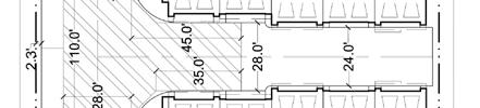
9 2.0 PROJECT DESCRIPTION 2.1 Site Location The proposed project site is located at South nue within the City of Gardena, California. The proposed project is situated along the east side of nue, just south of 169 th Place. The existing development site is bounded by residential and commercial development to the north, commercial development to the south, residential development to the east, and Western Avenue to the west. The proposed S. nue Townhomes project site location and general vicinity are shown in Figure Existing Project Site The existing project site comprises approximately 2.31 acres and is currently occupied by a recreational vehicle (e.g., boats, RVs, etc.) surface storage facility. A total of roughly 198 angle parking spaces are currently provided for recreational vehicles on the existing project site. All of the existing surface parking facility will be removed to accommodate development of the proposed project. An aerial photograph of the existing project site, the adjacent roadways, and the existing site access points is presented in Figure 2-1. As indicated in Figure 2-1, the existing project site currently accommodates vehicular access via two site driveways located along the westerly property frontage (i.e., along nue). 2.3 Project Description The proposed project consists of the development of a multi-family residential complex with townhome type dwelling units. A total of 46 townhome dwelling units is planned to be provided within the proposed S. nue Townhomes project site. Construction of the proposed project is expected to commence in year 2017 with build-out in year The site plan for the proposed project is illustrated in Figure 2 2. Vehicular access to the proposed project is planned to be provided via a single driveway on nue. Further discussion of the project s site access and circulation scheme is provided in Section Project Parking The number of parking spaces required to support the S. nue Townhomes project was calculated using the parking City Code requirements as contained in Chapter Off-Street Parking and Loading of the City of Gardena Municipal Code and applied to the number of townhome dwelling units. Specifically, Section (Number of spaces required) applies to the proposed land use associated with the proposed S. nue Townhomes project. The City s Code parking requirements for the proposed land use are as follows: A. Two Family and Multiple-family dwellings: Two spaces in a garage or in an enclosed parking facility, per dwelling unit. LINSCOTT, LAW & GREENSPAN, engineers LLG Ref S. nue Townhomes Project O:\JOB_FILE\4192\Report\4192-Rpt2.doc
10 - 6 -
11 - 7 -
12 Direct application of the City Code parking requirements for the project site results in a City Code requirement of 92 parking spaces. A total of 115 parking spaces, including 92 resident spaces and 23 guest spaces, is planned to be provided as part of the proposed project. Accordingly, the planned site parking supply more than satisfies the City Code parking requirement for the proposed S. nue Townhomes project. LINSCOTT, LAW & GREENSPAN, engineers LLG Ref S. nue Townhomes Project O:\JOB_FILE\4192\Report\4192-Rpt2.doc
13 3.0 SITE ACCESS AND CIRCULATION 3.1 Existing Vehicular Site Access As indicated in Figure 2-1, the existing project site currently accommodates vehicular access via two site driveways located along the westerly property frontage (i.e., along nue). The southerly driveway presently provides inbound access to the site and accommodates both left-turn and right-turn ingress turning movements. The internal drive-aisle is one-way allowing for a counterclockwise circulation scheme and back-in/head-out movements into/out of the recreational vehicle surface parking spaces. The northerly driveway presently provides outbound access from the site and accommodates both left-turn and right-turn egress turning movements. These access points will be closed as part of the proposed project. 3.2 Proposed Project Vehicular Site Access As presented in Figure 2-2, vehicular access to the proposed project is planned to be provided via a single driveway on nue. The proposed project site driveway will be located along the westerly property frontage (i.e., along nue) at the northwest corner of the project site. The planned project site driveway will be situated in essentially the same location as the existing northerly site driveway. The proposed project site driveway will accommodate left-turn and rightturn vehicular ingress and egress turning movements. The project site driveway will be constructed to City of Gardena design standards. 3.3 Pedestrian Access The proposed S. nue Townhomes project is located along a major corridor and in close proximity to numerous commercial business land uses. The project is well located to encourage pedestrian activity and walking as a transportation mode. 4 Walkability is a term for the extent to which walking is readily available as a safe, connected, accessible and pleasant mode of transport. There are several criteria that are widely accepted as key aspects of the walkability of urban areas that should be satisfied. The underlying principle is that pedestrians should not be delayed, diverted, or placed in danger. The widely accepted characteristics of walkability are as follows: Connectivity: People can walk from one place to another without encountering major obstacles, obstructions, or loss of connectivity. Convivial: Pedestrian routes are friendly and attractive, and are perceived as such by pedestrians. 4 For example, refer to which generates a walkability score of approximately 81 (Very Walkable) out of 100 for the project site. Walk Score calculates the walkability of an address by locating nearby stores, restaurants, schools, parks, etc. Walk Score measures how easy it is to live a car-lite lifestyle not how pretty the area is for walking. LINSCOTT, LAW & GREENSPAN, engineers LLG Ref S. nue Townhomes Project O:\JOB_FILE\4192\Report\4192-Rpt2.doc
14 Conspicuous: Suitable levels of lighting, visibility and surveillance over its entire length, with high quality delineation and signage. Comfortable: High quality and well-maintained footpaths of suitable widths, attractive landscaping and architecture, shelter and rest spaces, and a suitable allocation of roadspace to pedestrians. Convenient: Walking is a realistic travel choice, partly because of the impact of the other criteria set forth above, but also because walking routes are of a suitable length as a result of land use planning with minimal delays. The project site is situated within walking distance to retail, restaurant, and other commercial businesses within the area. Pedestrian amenities in the area foster a favorable environment for walking as a transportation mode, which is evidenced by the considerable level of pedestrian activity in the area. Further, regional and local public bus transit stops are provided nearby on Western Avenue, 169 th Place and Artesia Boulevard. LINSCOTT, LAW & GREENSPAN, engineers LLG Ref S. nue Townhomes Project O:\JOB_FILE\4192\Report\4192-Rpt2.doc
15 4.0 EXISTING STREET SYSTEM 4.1 Study Intersections Immediate access to the proposed S. nue Townhomes project site is via Western Avenue. The following two study intersections were selected for analysis in consultation with City staff in order to determine potential impacts related to the proposed project: 1. nue/169 th Place 2. nue/artesia Boulevard Both of the study intersections are presently controlled by traffic signals. The existing roadway configurations and intersection controls at the study intersections are displayed in Figure Roadway Classifications The City of Gardena utilizes the roadway categories recognized by regional, state and federal transportation agencies. There are four categories in the roadway hierarchy, ranging from freeways with the highest capacity to two-lane undivided roadways with the lowest capacity. The roadway categories are summarized as follows: Freeways are limited-access and high speed travel ways included in the state and federal highway systems. Their purpose is to carry regional through-traffic. Access is provided by interchanges with typical spacing of one mile or greater. No local access is provided to adjacent land uses. Arterial roadways are major streets that primarily serve through-traffic and provide access to abutting properties as a secondary function. Arterials are generally designed with two to six travel lanes and their major intersections are signalized. This roadway type is divided into two categories: principal and minor arterials. Principal arterials are typically four-or-more lane roadways and serve both local and regional through-traffic. Minor arterials are typically two-tofour lane streets that service local and commute traffic. Collector roadways are streets that provide access and traffic circulation within residential and non-residential (e.g., commercial and industrial) areas. Collector roadways connect local streets to arterials and are typically designed with two through travel lanes (i.e., one through travel lane in each direction) that may accommodate on-street parking. They may also provide access to abutting properties. Local roadways distribute traffic within a neighborhood, or similar adjacent neighborhoods, and are not intended for use as a through-street or a link between higher capacity facilities such as collector or arterial roadways. Local streets are fronted by residential uses and do not typically serve commercial uses. LINSCOTT, LAW & GREENSPAN, engineers LLG Ref S. nue Townhomes Project O:\JOB_FILE\4192\Report\4192-Rpt2.doc
16 - 12 -
17 4.3 Roadway Descriptions A review of the important roadways in the project vicinity and study area is summarized in Table 4-1. As indicated in Table 4-1, the roadways within the project study area were reviewed in terms of the number of lanes provided, median types, posted speed limits, etc. Additionally, the roadway classifications of key roads in the project study area also are presented in Table Existing Public Bus Transit Service Public bus transit service within the project study area is currently provided by Los Angeles County Metropolitan Transportation Authority (Metro) and City of Gardena Transit. A summary of the existing transit service, including the transit route, destinations and peak hour headways is presented in Table 4 2. LINSCOTT, LAW & GREENSPAN, engineers LLG Ref S. nue Townhomes Project O:\JOB_FILE\4192\Report\4192-Rpt2.doc
18 Table 4-1 EXISTING ROADWAY DESCRIPTIONS Travel Lanes Median Speed Roadway Classification [1] Direction [2] No. Lanes [3] Types [4] Limit nue Arterial N/S 4 2WLT th Street Local Street E/W 2 N/A th Place Local Street E/W 2 N/A 25 Artersia Boulevard Arterial E/W 6 RMI 45 Notes: [1] Roadway classifications obtained from the City of Gardena General Plan, [2] Direction of roadways in the project area: N/S - North/South; and E/W - East/West. [3] Number of lanes in both directions of the roadway. [4] Median type of the road: RMI - Raised Median Island; 2WLT - 2-Way Left-Turn Lane; and N/A-Not Applicable. LINSCOTT, LAW & GREENSPAN, engineers LLG Ref S. nue Townhomes Project
19 Metro 130 Redondo Beach to Cerritos via Hermosa Beach, Harbor nue, Artesia Boulevard EB 2 2 Gateway, Compton, North Long Beach and Bellflower WB 3 2 Metro 344 Rancho Palos Verdes to Harbor Gateway via Rolling Hills nue, Artesia Boulevard NB 3 3 Estates, Lawndale and Gardena SB 4 1 Gardena Transit Line 2 Torrance to Gardena via Harbor Gateway nue, Artesia Boulevard, NB th Place SB 6 4 Total LINSCOTT, LAW & GREENSPAN, engineers LLG Ref S. nue Townhomes Project Table 4-2 EXISTING TRANSIT ROUTES [1] NO. OF BUSES/TRAINS ROADWAY(S) DURING PEAK HOUR ROUTE DESTINATIONS NEAR SITE DIR AM PM [1] Sources: City of Los Angeles (Metro) and City of Gardena Transit websites, 2016.
20 5.0 TRAFFIC COUNTS New manual counts of vehicular turning movements were conducted at each of the study intersections during the weekday morning (AM) and afternoon (PM) commute periods to determine the peak hour traffic volumes. The manual counts were conducted by an independent traffic count subconsultant (City Traffic Counters) at the study intersections from 7:00 to 9:00 AM to determine the weekday AM peak commute hour, from 4:00 to 6:00 PM to determine the weekday PM peak commute hour. In conjunction with the manual turning movement vehicle counts, a count of bicycle and pedestrian volumes were also collected during the peak periods. It is noted that all of the traffic counts were conducted when local schools were in session. Traffic volumes at the study intersections show the typical peak periods between 7:00 to 9:00 AM and 4:00 to 6:00 PM generally associated with metropolitan area weekday peak commute hours. The weekday peak hour manual counts of vehicle movements at the study intersections are summarized in Table 5-1. The existing traffic volumes at the study intersections during the weekday AM and PM peak hours are shown in Figures 5-1 and 5-2, respectively. Summary data worksheets of the manual traffic counts at the study intersections are contained in Appendix A. LINSCOTT, LAW & GREENSPAN, engineers LLG Ref S. nue Townhomes Project O:\JOB_FILE\4192\Report\4192-Rpt2.doc
21 Table 5-1 EXISTING TRAFFIC VOLUMES [1] WEEKDAY AM AND PM PEAK HOURS AM PEAK HOUR PM PEAK HOUR NO. INTERSECTION DATE DIR BEGAN VOLUME BEGAN VOLUME 1 nue/ 09/27/2016 NB 7:15 1,178 5:00 1, th Place SB 1,123 1,297 EB 3 4 WB nue/ 09/27/2016 NB 7: :00 1,138 Artesia Boulevard SB EB 1,046 1,572 WB 1,455 1,367 [1] Counts conducted by City Traffic Counters LINSCOTT, LAW & GREENSPAN, engineers LLG Ref S. nue Townhomes Project
22 - 18 -
23 - 19 -
24 6.0 CUMULATIVE DEVELOPMENT PROJECTS The forecast of future pre-project conditions was prepared in accordance to procedures outlined in Section of the CEQA Guidelines. Specifically, the CEQA Guidelines provides two options for developing the future traffic volume forecast: (A) A list of past, present, and probable future projects producing related or cumulative impacts, including, if necessary, those projects outside the control of the [lead] agency, or (B) A summary of projections contained in an adopted local, regional or statewide plan, or related planning document, that describes or evaluates conditions contributing to the cumulative effect. Such plans may include: a general plan, regional transportation plan, or plans for the reduction of greenhouse gas emissions. A summary of projections may also be contained in an adopted or certified prior environmental document for such a plan. Such projections may be supplemented with additional information such as a regional modeling program. Any such document shall be referenced and made available to the public at a location specified by the lead agency. Accordingly, the traffic analysis provides a highly conservative estimate of future pre-project traffic volumes as it incorporates both the A and B options outlined in the CEQA Guidelines for purposes of developing the forecast. 6.1 Cumulative Growth A forecast of on-street traffic conditions prior to occupancy of the proposed project was prepared by incorporating the potential trips associated with other known development projects (related projects) in the area. With this information, the potential impact of the proposed project can be evaluated within the context of the cumulative impact of all ongoing development. The list of related projects was based on information on file at the City of Gardena, City of Los Angeles and City of Torrance, as well as recently accepted traffic impact analysis reports prepared for projects in the vicinity of the proposed S. nue Townhomes project site. The list of related projects in the project site area is presented in Table 6 1. The location of the related projects is shown in Figure 6 1. Traffic volumes expected to be generated by the related projects were calculated using rates provided in the Institute of Transportation Engineers (ITE) Trip Generation Manual 5. The related projects respective traffic generation for the weekday AM and PM peak hours, as well as on a daily basis for a typical weekday, is summarized in Table 6-1. The distribution of the related projects traffic volumes to the study intersections during the weekday AM and PM peak hours are displayed in Figures 6-2 and 6-3, respectively. 5 Institute of Transportation Engineers Trip Generation manual, 9 th Edition, 2012, Washington, D.C. LINSCOTT, LAW & GREENSPAN, engineers LLG Ref S. nue Townhomes Project O:\JOB_FILE\4192\Report\4192-Rpt2.doc
25 PROJECT DAILY AM PEAK HOUR PM PEAK HOUR MAP PROJECT PROJECT NAME/NUMBER LAND USE DATA DATA TRIP ENDS [2] VOLUMES [2] VOLUMES [2] NO. STATUS ADDRESS/LOCATION LAND-USE SIZE SOURCE VOLUMES IN OUT TOTAL IN OUT TOTAL City of Gardena G1 Approved Olson Urban Housing Condominiums 42 DU [3] Van Ness Avenue G2 Approved Water Pointe Commercial Commerical 5,000 GLSF [4] West Redondo Boulevard G3 Approved 1147 West Gardena Boulevard Single-Family Residential 4 DU [5] G4 Approved Brighton Avenue Single-Family Residential 3 DU [5] LA1 Proposed Home Depot Retail 143,159 GLSF [1] 2,040 (50) 37 (13) West Redondo Beach Boulevard T2 Proposed CUP (MOD ) Retail/Food Service 7,300 GSF [7] nue T3 Proposed CUP Condominiums 6 DU [3] Van Ness Avenue TOTAL 3, LINSCOTT, LAW & GREENSPAN, engineers LLG Ref S. nue Townhomes Project Table 6-1 RELATED PROJECTS LIST AND TRIP GENERATION [1] City of Los Angeles City of Torrance T1 Proposed CUP Church Expansion 55,000 GSF [6] Artesia Boulevard [1] Source: City of Gardena Planning Department, City of Los Angeles Department of Transportation (LADOT), and City of Torrance Commnuity Development Department. Trip generation for the related projects are based on ITE "Trip Generation Manual", 9th Edition, 2012 (as referenced in the Project Data Source column). [2] Trips are one-way traffic movements, entering or leaving. [3] ITE Land Use Code 230 (Residential Condo./Townhouse) trip generation average rates. [4] ITE Land Use Code 820 (Shopping Center) trip generation average rates. [5] ITE Land Use Code 210 (Single-Family Detached Housing) trip generation average rates. [6] ITE Land Use Code 560 (Church) trip generation average rates. [7] ITE Land Use Code 932 (High-Turnover (Sit-Down) Restaurant) trip generation average rates.
26 - 22 -
27 - 23 -
28 - 24 -
29 6.2 Ambient Traffic Growth In order to account for area-wide regional growth not included in this analysis, the existing traffic volumes were increased at an annual rate of one percent (1.0%) to the year 2019 (i.e., the anticipated year of project build-out). The ambient growth factor was based on general traffic growth factors provided in the 2010 Congestion Management Program for Los Angeles County (the CMP manual ). It is noted that based on review of the general traffic growth factors provided in the CMP manual for the project study area (i.e., RSA 18), it is anticipated that the existing traffic volumes are expected to increase at an annual rate of less than 1.0% per year between the years 2015 and Thus, application of the 1.0% annual growth factor allows for a conservative forecast of future traffic volumes in the area that likely overstates future traffic volumes. Further, it is noted that the CMP manual s traffic growth rate is intended to anticipate future traffic generated by development projects in the project vicinity. Thus, the inclusion in this traffic analysis of both a forecast of traffic generated by known related projects plus the use of an ambient traffic growth factor based on CMP traffic model data results in a conservative estimate of future traffic volumes at the study intersections. LINSCOTT, LAW & GREENSPAN, engineers LLG Ref S. nue Townhomes Project O:\JOB_FILE\4192\Report\4192-Rpt2.doc
30 7.0 TRAFFIC FORECASTING METHODOLOGY In order to estimate the traffic impact characteristics of the S. nue Townhomes project, a multi-step process has been utilized. The first step is trip generation, which estimates the total arriving and departing traffic volumes on a peak hour and daily basis. The traffic generation potential is forecast by applying the appropriate vehicle trip generation equations or rates to the project development tabulation. The second step of the forecasting process is trip distribution, which identifies the origins and destinations of inbound and outbound project traffic volumes. These origins and destinations are typically based on demographics and existing/anticipated travel patterns in the study area. The third step is traffic assignment, which involves the allocation of project traffic to study area streets and intersections. Traffic assignment is typically based on minimization of travel time, which may or may not involve the shortest route, depending on prevailing operating conditions and travel speeds. Traffic distribution patterns are indicated by general percentage orientation, while traffic assignment allocates specific volume forecasts to individual roadway links and intersection turning movements throughout the study area. With the forecasting process complete and project traffic assignments developed, the impact of the proposed project is isolated by comparing operational (i.e., Levels of Service) conditions at the selected key intersections using existing and expected future traffic volumes with and without forecast project traffic. The need for site-specific and/or cumulative local area traffic improvements can then be evaluated and the significance of the project s impacts identified. 7.1 Project Traffic Generation Traffic volumes expected to be generated by the proposed S. nue Townhomes project and the existing site uses during the weekday AM and PM peak hours, as well as on a daily basis, were estimated using rates published in the ITE Trip Generation Manual. Traffic volumes expected to be generated by the proposed project were based upon rates per number of dwelling units. ITE Land Use Code 232 (Residential Townhome/Condominium) trip generation average rates were used to forecast the traffic volumes expected to be generated by the proposed project land use. Additionally, it is noted that no trip generation credit for the existing recreational vehicle storage facility on the project site has been employed in the trip generation forecasts in order to provide a conservative analysis. The weekday trip generation rates and forecast of the vehicular trips anticipated to be generated by the proposed project are presented in Table 7-1. As presented in Table 7-1, the proposed project is expected to generate 20 vehicle trips (3 inbound trips and 17 outbound trips) during the weekday AM peak hour. During the weekday PM peak hour, the proposed project is expected to generate 24 vehicle trips (16 inbound trips and 8 outbound trips). Over a 24-hour period, the proposed project is forecast to generate 267 daily trip ends during a typical weekday (approximately 134 inbound trips and 134 outbound trips). LINSCOTT, LAW & GREENSPAN, engineers LLG Ref S. nue Townhomes Project O:\JOB_FILE\4192\Report\4192-Rpt2.doc
31 Table 7-1 PROJECT TRIP GENERATION [1] DAILY AM PEAK HOUR PM PEAK HOUR TRIP ENDS [2] VOLUMES [2] VOLUMES [2] LAND USE SIZE VOLUMES IN OUT TOTAL IN OUT TOTAL Townhomes [3] 46 DU NET INCREASE [1] Source: ITE "Trip Generation Manual", 9th Edition, [2] Trips are one-way traffic movements, entering or leaving. [3] ITE Land Use Code 230 (Residential Condominium/Townhouse) trip generation average rates. - Daily Trip Rate: 5.81 trips/dwelling unit; 50% inbound/50% outbound - AM Peak Hour Trip Rate: 0.44 trips/dwelling units; 17% inbound/83% outbound - PM Peak Hour Trip Rate: 0.52 trips/dwelling units; 67% inbound/33% outbound LINSCOTT, LAW & GREENSPAN, engineers LLG Ref S. nue Townhomes Project
32 7.2 Project Trip Distribution and Assignment Project traffic volumes both entering and exiting the site have been distributed and assigned to the adjacent street system based on the following considerations: The site's proximity to major traffic corridors (i.e., nue, Artesia Boulevard, etc.); The location and spatial proximity of nearby restaurants, banks, coffee shops and similar type businesses, as well as local schools; Expected localized traffic flow patterns based on adjacent roadway channelization and presence of traffic signals; Existing intersection traffic volumes; Existing site parcel access ingress/egress schemes; Ingress/egress scheme planned for the proposed project; Nearby population and employment centers; and Input from City staff. The project traffic volume distribution percentages during weekday AM and PM peak hours at the study intersections are illustrated in Figure 7-1. The forecast project traffic volumes at the study intersections for the weekday AM and PM peak hours are displayed in Figures 7-2 and 7-3, respectively. The traffic volume assignments presented in Figures 7-2 and 7-3 reflect the traffic distribution characteristics shown in Figure 7-1 and the project traffic generation forecasts presented in Table 7-1. LINSCOTT, LAW & GREENSPAN, engineers LLG Ref S. nue Townhomes Project O:\JOB_FILE\4192\Report\4192-Rpt2.doc
33 - 29 -
34 - 30 -
35 - 31 -
36 8.0 TRAFFIC IMPACT ANALYSIS METHODOLOGY 8.1 Intersection Analysis Methodology The two study intersections were evaluated using the Intersection Capacity Utilization (ICU) method of analysis which determines Volume-to-Capacity (v/c) ratios on a critical lane basis. The overall intersection v/c ratio is subsequently assigned a Level of Service (LOS) value to describe intersection operations. Level of Service varies from LOS A (free flow condition) to LOS F (jammed condition). A description of the ICU method and corresponding Level of Service is provided in Appendix B. 8.2 Intersection Impact Criteria and Thresholds While the City of Gardena has established performance criteria for evaluating the circulation system (refer to Table CI-2 of the Community Development Element Circulation Plan), there is no established impact criteria for study intersections. Accordingly, based on coordination with City staff, the significance of the potential project-generated traffic impacts was identified using the traffic impact analysis guidelines set forth in the LACDPW Traffic Impact Analysis Report Guidelines. According to the County s published guidelines, the impact is considered significant if the project-related increase in the v/c ratio equals or exceeds the threshold criteria presented in Table 8-1. Table 8-1 COUNTY OF LOS ANGELES INTERSECTION IMPACT THRESHOLD CRITERIA Pre-Project v/c Level of Service Project Related Increase in v/c 0.71 to 0.80 C equal to or greater than to 0.90 D equal to or greater than or more E / F equal to or greater than 0.01 According to the City of Gardena performance criteria and County of Los Angeles requirements, the ICU calculations utilize a lane capacity of 1,600 vehicles per hour (vph) per lane for left-turn, through, and right-turn lanes, and 2,880 vph for dual left-turn lanes. Additionally, a clearance factor of 0.10 is included in the ICU calculations. The Sliding Scale Method requires mitigation of project traffic impacts whenever traffic generated by the proposed development causes an increase in the analyzed intersection v/c ratio by an amount equal to or greater than the values shown above. The relative impact of the added project traffic volumes to be generated by the proposed S. nue Townhomes project during the weekday AM and PM peak hours was evaluated based on analysis of existing and future operating conditions at the study intersections, without and with the proposed project. The previously discussed capacity analysis procedures were utilized to evaluate the future v/c relationships and service level characteristics at each study intersection. LINSCOTT, LAW & GREENSPAN, engineers LLG Ref S. nue Townhomes Project O:\JOB_FILE\4192\Report\4192-Rpt2.doc
37 8.3 Intersection Traffic Impact Analysis Scenarios Traffic impacts at the study intersections were analyzed for the following conditions: [a] [b] [c] [d] [e] [f] Existing conditions. Existing with project conditions. Condition [b] with implementation of project mitigation measures, where necessary. Condition (a) plus one percent (1.0%) annual ambient traffic growth through year 2019 and with completion and occupancy of the related projects (i.e., future without project conditions). Condition [d] with completion and occupancy of the proposed project. Condition [e] with implementation of project mitigation measures, where necessary. The project traffic volumes were added for each new condition volumes (i.e., existing condition and future without project conditions) to determine the change in capacity utilization at the study intersections. LINSCOTT, LAW & GREENSPAN, engineers LLG Ref S. nue Townhomes Project O:\JOB_FILE\4192\Report\4192-Rpt2.doc
38 9.0 TRAFFIC ANALYSIS The traffic impact analysis prepared for the study intersections using the ICU methodology and application of the City of Gardena significant traffic impact criteria is summarized in Table 9 1. The ICU data worksheets for the analyzed intersections are contained in Appendix B. 9.1 Existing Conditions Existing Conditions As indicated in column [1] of Table 9 1, Study Intersection No. 1, nue/169 th Place, is presently operating at LOS A during both the weekday AM and PM peak hours under existing conditions. Study Intersection No. 2, nue/artesia Boulevard, is currently operating at LOS D and LOS E during the weekday AM and PM peak hours, respectively, under existing conditions. As previously mentioned, the existing traffic volumes at the study intersections during the weekday AM, PM and Saturday AM peak hours are displayed in Figures 5 1, 5 2, and 5 3, respectively Existing With Project Conditions As shown in column [2] of Table 9 1, application of the study intersection threshold criteria (refer to Table 8-1) to the Existing With Project scenario indicates that the proposed project is not expected to create significant impacts at either of the two study intersections. Incremental, but not significant, impacts are noted at the study intersections. Because there are no significant impacts, no traffic mitigation measures are required or recommended for the study intersections under the Existing With Project conditions. The existing with project traffic volumes at the study intersections during the weekday AM and PM peak hours are illustrated in Figures 9 1 and 9 2, respectively. 9.2 Future Conditions Future Without Project Conditions The future cumulative baseline conditions were forecast based on the addition of traffic generated by the completion and occupancy of related projects, as well as the growth in traffic due to the combined effects of continuing development, intensification of existing developments and other factors (i.e., ambient growth). The v/c ratios at the study intersections are incrementally increased with the addition of ambient traffic and traffic generated by the related projects listed in Table 6 1. As presented in column [3] of Table 9 1, Study Intersection No. 1, nue/169 th Place, is expected to operate at LOS A and LOS B during the weekday AM and PM peak hours, respectively, with the addition of growth in ambient traffic and related projects traffic under the future without project conditions. Study Intersection No. 2, nue/artesia Boulevard, is expected to operate at LOS D and LOS E during the weekday AM and PM peak hours, respectively, with the addition of growth in ambient traffic and related projects traffic under the future without project conditions. The future without project (existing, ambient growth and related projects) traffic volumes at the study intersections during the weekday AM and PM peak hours are presented in Figures 9 3 and 9 4, respectively. LINSCOTT, LAW & GREENSPAN, engineers LLG Ref S. nue Townhomes Project O:\JOB_FILE\4192\Report\4192-Rpt2.doc
39 [1] [2] [3] [4] YEAR 2019 YEAR 2019 YEAR 2016 FUTURE FUTURE YEAR 2016 EXISTING W/ CHANGE WITHOUT WITH CHANGE EXISTING PROJECT V/C or SIGNIF. PROJECT PROJECT V/C or SIGNIF. PEAK V/C or LOS V/C or LOS DELAY IMPACT V/C or LOS V/C or LOS DELAY IMPACT NO. INTERSECTION HOUR DELAY [a] Delay [a] [(2)-(1)] [b] DELAY [a] DELAY [a] [(4)-(3)] [b] 1 nue/ AM A A No A A No 169th Place PM A A No B B No 2 nue/ AM D D No D D No Artesia Boulevard PM E E No E E No LINSCOTT, LAW & GREENSPAN, engineers LLG Ref S. nue Townhomes Project Table 9-1 SUMMARY OF VOLUME TO CAPACITY RATIOS AND LEVELS OF SERVICE WEEKDAY AM AND PM PEAK HOURS [a] Level of Service (LOS) is based on the reported ICU value for signalized intersections and the delay value for unsignalized intersections. [b] According to the County of Los Angeles Department of Public Works' Traffic Impact Analysis Report Guidelines, January 1, 1997, Page 6: an impact is considered singificant if the project related increase in the volume-to-capacity ratio (v/c) equals or exceeds the thresholds shown below: Level of Service Pre-Project V/C Project-Related Increase in V/C C > equal to or greater than D > equal to or greater than E/F > equal to or greater than 0.010
40 - 36 -
41 - 37 -
42 - 38 -
43 - 39 -
44 9.2.2 Future With Project Conditions As shown in column [4] of Table 9 1, application of the study intersection threshold criteria (refer to Table 8-1) to the Future With Proposed Project scenario indicates that the proposed project is not expected to create significant impacts at either of the two study intersections. Incremental, but not significant, impacts are noted at the study intersections. Because there are no significant impacts, no traffic mitigation measures are required or recommended for the study intersections. The future with project (existing, ambient growth, related projects and project) traffic volumes at the study intersections during the weekday AM and PM peak hours are illustrated in Figures 9 5 and 9 6, respectively. LINSCOTT, LAW & GREENSPAN, engineers LLG Ref S. nue Townhomes Project O:\JOB_FILE\4192\Report\4192-Rpt2.doc
45 - 41 -
46 - 42 -
47 10.0 TRANSPORTATION IMPROVEMENT MEASURES The traffic analysis has been based on a conservative approach with respect to the analysis of potential project-related impacts. As summarized in Subsections (Existing With Project Conditions) and (Future With Project Conditions) herein, application of the study intersection threshold criteria (refer to Table 8-1) to the with proposed project scenarios indicates that the proposed project is not expected to create significant impacts at the two study intersections. Incremental, but not significant, impacts are noted at the study intersections. Because there are no significant impacts, no formal traffic mitigation measures are required or recommended for the study intersections. However, it is recommended that appropriate sight distance be provided at the project sight driveway in order to safely accommodate vehicles exiting the site as well as for pedestrians approaching the driveway along the adjacent public sidewalk. LINSCOTT, LAW & GREENSPAN, engineers LLG Ref S. nue Townhomes Project O:\JOB_FILE\4192\Report\4192-Rpt2.doc
48 11.0 CONGESTION MANAGEMENT PROGRAM TRAFFIC IMPACT ASSESSMENT The Congestion Management Program (CMP) is a state-mandated program that was enacted by the State Legislature with the passage of Proposition 111 in The program is intended to address the impact of local growth on the regional transportation system. As required by the 2010 Congestion Management Program for Los Angeles County, a Traffic Impact Assessment (TIA) has been prepared to determine the potential impacts on designated monitoring locations on the CMP highway system. The analysis has been prepared in accordance with procedures outlined in the 2010 Congestion Management Program for Los Angeles County, County of Los Angeles Metropolitan Transportation Authority, July Intersections The following CMP intersection monitoring locations in the project vicinity have been identified: CMP Station No. 21 No. 154 Intersection Artesia Boulevard/Vermont Avenue nue/190 th Street The CMP TIA guidelines require that intersection monitoring locations must be examined if the proposed project will add 50 or more trips during either the weekday AM or PM peak hours. The proposed project will not add 50 or more trips during either the weekday AM or PM peak hours (i.e., of adjacent street traffic) at CMP monitoring intersections, as stated in the CMP manual as the threshold criteria for a traffic impact assessment. Therefore, no further review of potential impacts to intersection monitoring locations that are part of the CMP highway system is required Freeways The following CMP freeway monitoring locations in the project vicinity have been identified: CMP Station No No No Segment SR-91 Freeway east of Alameda Street/Santa Fe Avenue I-110 Freeway at Wilmington, south of C Street I-110 Freeway at Manchester Boulevard The CMP TIA guidelines require that freeway monitoring locations must be examined if the proposed project will add 150 or more trips (in either direction) during either the weekday AM or PM peak periods. The proposed project will not add 150 or more trips (in either direction) during either the weekday AM or PM peak hours to CMP freeway monitoring locations which is the threshold for preparing a traffic impact assessment, as stated in the CMP manual. Therefore, no LINSCOTT, LAW & GREENSPAN, engineers LLG Ref S. nue Townhomes Project O:\JOB_FILE\4192\Report\4192-Rpt2.doc
49 further review of potential impacts to freeway monitoring locations that are part of the CMP highway system is required Transit Impact Review As required by the 2010 Congestion Management Program, a review has been made of the potential impacts of the project on transit service. As discussed in Subsection 4.4 herein, existing transit service is provided in the vicinity of the proposed S. nue Townhomes project. The project trip generation, as shown in Table 7 1 was adjusted by values set forth in the CMP (i.e., person trips equal 1.4 times vehicle trips, and transit trips equal 3.5 percent of the total person trips) to estimate transit trip generation. Pursuant to the CMP guidelines, the proposed project is forecast to generate transit demand as calculated below: Weekday AM Peak Hour = = 1 Transit Trip Weekday PM Peak Hour = = 1 Transit Trip Weekday Daily Trips = = 13 Transit Trips As shown in Table 4 2, three bus transit lines are provided adjacent to or in close proximity the project site. As outlined in Table 4 2, under the No. of Buses During Peak Hour column, these three transit lines provide services for an average of generally 22 and 16 buses during the weekday AM and PM peak hours. Therefore, based on the above calculated weekday AM and PM peak hour trips, this would correspond to less than one additional transit rider per bus. It is anticipated that the existing transit service in the project area will adequately accommodate the increase of projectgenerated transit trips. Thus, given the number of project-generated transit trips per bus, no project impacts on existing or future transit services in the project area are expected to occur due to the proposed project. LINSCOTT, LAW & GREENSPAN, engineers LLG Ref S. nue Townhomes Project O:\JOB_FILE\4192\Report\4192-Rpt2.doc
4. ENVIRONMENTAL IMPACT ANALYSIS 11. TRANSPORTATION AND CIRCULATION 1. TRAFFIC
 4. EVIROMETAL IMPACT AALYSIS 11. TRASPORTATIO AD CIRCULATIO 1. TRAFFIC 1. ITRODUCTIO The following section summarizes the information provided in the Traffic Impact Study, SMC Malibu Satellite Campus Project,
Future Build Alternative Traffic Forecasts and Level of Service Analysis
 4.2.10 Future Build Alternative Traffic Forecasts and Level of Service Analysis For the five Build Alternatives, study intersections within one mile of potential station locations were analyzed, as it
III. ENVIRONMENTAL IMPACT ANALYSIS F. TRAFFIC
 III. ENVIRONMENTAL IMPACT ANALYSIS F. TRAFFIC This section summarizes the traffic impact analysis prepared by Kaku Associates in May, 2002. Detailed calculation worksheets are contained in Appendix D to
BCEO TRAFFIC IMPACT STUDY GUIDELINES
 BCEO TRAFFIC IMPACT STUDY GUIDELINES February 2006 TABLE OF CONTENTS INTRODUCTION..... i TRAFFIC IMPACT STUDY STRUCTURE... 1 WHEN IS A TRAFFIC IMPACT STUDY NEEDED?..... 1 STUDY AREA, SITE PLAN & HORIZON
DIVISION I TRAFFIC IMPACT STUDY GUIDELINES ENGINEERING STANDARDS
 CITY OF ALBANY DEPARTMENT OF PUBLIC WORKS DIVISION I TRAFFIC IMPACT STUDY GUIDELINES ENGINEERING STANDARDS Prepared By PUBLIC WORKS DEPARTMENT ALBANY, OREGON 97321 Telephone: (541) 917-7676 TABLE OF CONTENTS
ALBION FLATS DEVELOPMENT EXISTING TRAFFIC CONDITIONS AND POTENTIAL IMPACTS
 EXISTING TRAFFIC CONDITIONS AND POTENTIAL IMPACTS FINAL REPORT SEPTEMBER 2010 TABLE OF CONTENTS 1.0 INTRODUCTION 1 2.0 EXISTING TRAFFIC CONDITIONS 2 3.0 FUTURE TRAFFIC CONDITIONS 3 4.0 POTENTIAL IMPACTS
Traffic Impact Analysis Guidelines. Town of Queen Creek
 Traffic Impact Analysis Guidelines Town of Queen Creek January 2016 1. INTRODUCTION The purpose of this document is to outline the procedures and requirements for preparing a Transportation Impact Analysis
APPENDIX B. Public Works and Development Engineering Services Division Guidelines for Traffic Impact Studies
 APPENDIX B Public Works and Development Engineering Services Division Guidelines for Traffic Impact Studies Revised December 7, 2010 via Resolution # 100991 Reformatted March 18, 2011 TABLE OF CONTENTS
TRANSPORTATION IMPACT ANALYSISGUIDELINES
 TRANSPORTATION IMPACT ANALYSISGUIDELINES ADOPTED OCTOBER2014 SANTACLARAVALLEYTRANSPORTATION AUTHORITY CONGESTION MANAGEMENTPROGRAM CONGESTION MANAGEMENT PROGRAM TRANSPORTATION IMPACT ANALYSIS GUIDELINES
CITY OF VALLEJO PUBLIC WORKS DEPARTMENT TRAFFIC IMPACT Analysis/Study GUIDELINES
 The City Engineer, under the authority of the Public Works Director and recommendations from the Traffic Engineer, will make the final decision on the need for a traffic study. The purpose of the traffic
3.6 GROUND TRANSPORTATION
 3.6.1 Environmental Setting 3.6.1.1 Area of Influence The area of influence for ground transportation consists of the streets and intersections that could be affected by automobile or truck traffic to
GUIDE FOR THE PREPARATION OF TRAFFIC IMPACT STUDIES
 GUIDE FOR THE PREPARATION OF TRAFFIC IMPACT STUDIES Adopted by Town Council on November 25, 2008 Prepared By: HNTB Engineering Department Planning Department TABLE OF CONTENTS I. INTRODUCTION... 1 II.
Traffic Impact Study Guidelines. City of Guelph
 Traffic Impact Study Guidelines City of Guelph April 2016 Engineering and Capital Infrastructure Services Infrastructure, Development & Enterprise 1 Carden Street Guelph, Ontario Canada N1H 3A1 Page 1
Date: May 4, Clare M. Look-Jaeger, P.E. Kevin C. Jaeger Linscott, Law & Greenspan, Engineers Weingart Projects Construction Traffic Analysis
 MEMORANDUM To: CAJA Environmental Services, LLC Date: From: Subject: Clare M. Look-Jaeger, P.E. Kevin C. Jaeger Linscott, Law & Greenspan, Engineers Weingart Projects Construction Traffic Analysis LLG
City of Menifee. Public Works Department. Traffic Impact Analysis Guidelines
 Public Works Department Traffic Impact Analysis Guidelines Revised: August 2015 TABLE OF CONTENTS INTRODUCTION... 3 PURPOSE... 3 EXEMPTIONS... 3 SCOPING... 4 METHODOLOGY... 5 STUDY AREA... 6 STUDY SCENARIOS...
Appendix G Analysis of Project Impacts Compared to Existing Conditions
 Appendix G Analysis of Project Impacts Compared to Existing Conditions This page intentionally left blank. Analysis of Project Impacts Compared to Existing Conditions Introduction The analysis scenarios
CITY OF LA MESA MIXED-USE OVERLAY ZONE PROJECT La Mesa, California August 15, 2007 Revised January 16, 2008
 TRAFFIC IMPACT STUDY CITY OF LA MESA MIXED-USE OVERLAY ZONE PROJECT La Mesa, California August 15, 2007 Revised January 16, 2008 Prepared for: DUDEK & ASSOCIATES 605 Third Street Encinitas, California
Article 16 Traffic Impact Analysis
 Article 16 Traffic Impact Analysis Table of Contents... 16-1 Chapter 16.1 Purpose and Intent... 16-2 Chapter 16.2 Applicability... 16-2 Chapter 16.3 Exemptions... 16-2 Chapter 16.4 Trip Generation Data...
CITY OF DRAPER TRAFFIC IMPACT STUDY DESIGN GUIDELINES
 CITY OF DRAPER TRAFFIC IMPACT STUDY DESIGN GUIDELINES June 1, 2012 Draper City Traffic Impact Study Guidelines Table of Contents Introduction... 1 Traffic Impact Classification Levels... 1 Analysis Approach
Traffic Impact Study Requirements
 [TYPE THE COMPANY NAME] Traffic Impact Study Requirements County of San Mateo Department of Public Works Roadway Services 9/1/2013 I. Introduction The County of San Mateo (County), Department of Public
TRAFFIC STUDY GUIDELINES
 TRAFFIC STUDY GUIDELINES December 2013 The scope of the traffic impact analysis (TIA) should follow these guidelines and the requirements of VMC 11.80.130 and VMC 11.70, transportation concurrency (attached
CITY OF CLOVIS Traffic Impact Study Guidelines
 CITY OF CLOVIS Traffic Impact Study Guidelines CLOVIS, A WAY OF LIFE Approved August 25, 2014 City Council Resolution 2014-79 Prepared by City of Clovis Engineering Division Steve White, City Engineer
City of Los Angeles 2010 Bicycle Plan First Year of the First Five-Year Implementation Strategy & Figueroa Streetscape Project Draft EIR
 5.0 ALTERNATIVES California Environmental Quality Act (CEQA) requires that an EIR describe a range of reasonable alternatives to the project or to the location of the project that could feasibly avoid
SECTION VII TRAFFIC IMPACT ANALYSIS GUIDELINES
 SECTION VII TRAFFIC IMPACT ANALYSIS GUIDELINES A. GENERAL Traffic Impact Analyses (TIAs) are tools that have historically been utilized to evaluate the interaction between existing transportation infrastructures
PROPOSED CALIFORNIA ENVIRONMENTAL QUALITY ACT (CEQA) TRANSPORTATION SECTION UPDATE
 TRANSPORTATION SECTION UPDATE") DRAFT DOCUMENT CITY OF LOS ANGELES PROPOSED CALIFORNIA ENVIRONMENTAL QUALITY ACT (CEQA) TRANSPORTATION SECTION UPDATE Prepared by: Departments of City Planning (DCP) and (LADOT) 3.xx 1 DRAFT 2018 LOS ANGELES
DRAFT DOCUMENT CITY OF LOS ANGELES PROPOSED CALIFORNIA ENVIRONMENTAL QUALITY ACT (CEQA) TRANSPORTATION SECTION UPDATE Prepared by: Departments of City Planning (DCP) and (LADOT) 3.xx 1 DRAFT 2018 LOS ANGELES
TRANSPORTATION IMPACT ANALYSIS GUIDELINES
 TRANSPORTATION IMPACT ANALYSIS GUIDELINES SANTA CLARA COUNTY TRANSPORTATION AUTHORITY CONGESTION MANAGEMENT PROGRAM ADOPTED MARCH 2009 TABLE OF CONTENTS PART I - STATUTE AND AUTHORITY...1 CHAPTER 1. CMP
TRANSPORTATION MOBILITY PLAN GUIDELINES
 TRANSPORTATION MOBILITY PLAN GUIDELINES for Development Applications November 2016 Executive Summary The Regional Municipality of York (the Region) is located in the heart of the Greater Toronto Area (GTA)
City of Lake Forest SERRANO SUMMIT (IRWD SITE) Traffic Study. April 2010
 Traffic Study. April 2010") G: Traffic Study City of Lake Forest SERRANO SUMMIT (IRWD SITE) Traffic Study April 2010 Draft City of Lake Forest SERRANO SUMMIT (IRWD SITE) Traffic Study Prepared by: Austin-Foust Associates, Inc. 2223
G: Traffic Study City of Lake Forest SERRANO SUMMIT (IRWD SITE) Traffic Study April 2010 Draft City of Lake Forest SERRANO SUMMIT (IRWD SITE) Traffic Study Prepared by: Austin-Foust Associates, Inc. 2223
BAY MEADOWS II TRAFFIC MANAGEMENT PLAN
 FINAL BAY MEADOWS II TRAFFIC MANAGEMENT PLAN Prepared For: WILSON MEANY Four Embarcadero Center, Suite 3330 San Francisco, CA 94111 Prepared By: Original: March 17, 2008 Updated: December 4, 2012 Revised
TOWN OF MOORESVILLE TRANSPORTATION IMPACT ANALYSIS PROCEDURES MANUAL TOWN OF MOORESVILLE, NORTH CAROLINA
 TOWN OF MOORESVILLE TRANSPORTATION IMPACT ANALYSIS PROCEDURES MANUAL TOWN OF MOORESVILLE, NORTH CAROLINA Effective August 1, 2007 Amended March 4, 2013, December 1, 2014, May 1, 2017 TOWN OF MOORESVILLE,
BAY MEADOWS II TRAFFIC MANAGEMENT PLAN
 FINAL BAY MEADOWS II TRAFFIC MANAGEMENT PLAN Prepared For: WILSON MEANY SULLIVAN Four Embarcadero Center, Suite 3330 San Francisco, CA 94111 Prepared By: TABLE OF CONTENTS Executive Summary...4 1 Introduction...7
City of Berkeley. Guidelines for Development of Traffic Impact Reports
 Office of Transportation (OOT) City of Berkeley Guidelines for Development of Traffic Impact Reports Office of Transportation, City of Berkeley 1 1. Overview These guidelines provide a framework to help
Woodburn Interchange Project Transportation Technical Report
 Final Report Woodburn Interchange Project Transportation Technical Report Prepared for Oregon Department of Transportation April 212 Prepared by DKS Associates Contents Methodologies... 4 Volume Development...
Guidelines for the Submission of a Transportation Study Level 2
 Guidelines for the Submission of a Transportation Study Level 2 For Site Development Applications in the City of North Vancouver Transportation Group, City of North Vancouver Engineering, Parks & Environment
APPENDIX I. Traffic Study
 APPENDIX I Traffic Study May 24, 2017 Mr. Tom Dodson Tom Dodson & Associates 2150 North Arrowhead Avenue San Bernardino, CA 92405 SUBJECT: LIBERTY LANE APARTMENTS FOCUSED TRAFFIC ASSESSMENT Dear Mr. Tom
5.4.1 METHODOLOGY AND PERFORMANCE CRITERIA
 Section 5.4 TRAFFIC 5.4 TRAFFIC This section evaluates the impacts of the proposed project on the local traffic system in the vicinity of the project site. This analysis summarizes the findings of the
Traffic and Parking. Introduction. 3G.2 Environmental Setting. Description of Key Roadways
 3G 3G.1 Traffic and Parking Introduction This section presents the methodology, findings, and conclusions of the traffic impact analysis prepared by Allyn D. Rifkin, transportation planner/engineer for
SITE AREA AERIAL PHOTO
 ward consulting group EXHIBIT 1.2 SITE AREA AERIAL PHOTO 168 STREET 164 STREET 32 AVENUE 28 AVENUE 24 AVENUE 160 STREET HIGHWAY 99 156 STREET HIGHWAY 99A PHOTO DATE: YEAR 2004 152 STREET 1480 ward consulting
VIII. LAND USE ISSUES
 VIII. LAND USE ISSUES The & Route 57 Land Use and Circulation Study (Land Use Study, Figure 6) was completed for the Town of Clay in November 1999 (Clough, Harbour & Associates). This study investigated
CHAPTER 12 TRANSPORTATION. Introduction Setting Impacts and Mitigation Measures of the 2015 Plan Alternatives
 CHAPTER 2 TRANSPORTATION Introduction Setting Impacts and Mitigation Measures of the 205 Plan Alternatives CHAPTER 2 TRANSPORTATION INTRODUCTION This chapter presents the traffic impact analysis conducted
ADDENDUM TO THE EIR. Specifically, Section of the CEQA Guidelines states:
 ADDENDUM TO THE EIR Section 15160 of the CEQA Guidelines explains that there are several mechanisms, and variations in environmental documents, that can be tailored to different situations and intended
New Transportation Performance Measures for Transportation Analysis and Thresholds for CEQA
 New Transportation Performance Measures for Transportation Analysis and Thresholds for CEQA Transportation Advisory Commission September 11, 2014 Transportation Performance Measures Overview of OPR s Draft
Vicinity Map. Interstate 605 (I-605) and State Route 91 (SR-91) in Los Angeles County
 and State Route 91 (SR-91) in Los Angeles County") 07 - LA - 605 - PM 2.87/PM 6.36 07 - LA - 91 - PM 14.10/PM 19.81 Vicinity Map N On Routes Interstate 605 (I-605) and State Route 91 (SR-91) in Los Angeles County I-605 between Excelsior Dr UC (PM 6.36)
07 - LA - 605 - PM 2.87/PM 6.36 07 - LA - 91 - PM 14.10/PM 19.81 Vicinity Map N On Routes Interstate 605 (I-605) and State Route 91 (SR-91) in Los Angeles County I-605 between Excelsior Dr UC (PM 6.36)
TRAFFIC & TRANSPORTATION COMMISSION AGENDA REPORT
 TRAFFIC & TRANSPORTATION COMMISSION AGENDA REPORT AGENDA ITEM #4 T/T MTG: 092616 DATE: SEPTEMBER 26, 2016 TO: TRAFFIC & TRANSPORTATION COMMISSION FROM: BENJAMIN CHAN, P.E, T.E., DEPUTY PUBLIC WORKS DIRECTOR
TABLE OF CONTENTS TABLE OF CONTENTS... I APPENDICES... III LIST OF EXHIBITS... V LIST OF TABLES... VII LIST OF ABBREVIATED TERMS...
 Amendment No. 2 to Reclamation Plan 2006-01 Traffic Impact Analysis TABLE OF CONTENTS TABLE OF CONTENTS... I APPENDICES... III LIST OF EXHIBITS... V LIST OF TABLES... VII LIST OF ABBREVIATED TERMS... IX
Rivers Edge Alternative Urban Areawide Review (AUAR) Traffic Study
 Traffic Study") Appendix F Rivers Edge Alternative Urban Areawide Review (AUAR) Traffic Study Prepared by Westwood Professional Services, Inc. for City of St. Paul Park Grey Cloud Island Township October 14, 2003 Introduction
Appendix F Rivers Edge Alternative Urban Areawide Review (AUAR) Traffic Study Prepared by Westwood Professional Services, Inc. for City of St. Paul Park Grey Cloud Island Township October 14, 2003 Introduction
M D 355 [FR E D E R IC K R O A D] OVER
![M D 355 [FR E D E R IC K R O A D] OVER](/thumbs/79/79553721.jpg "M D 355 [FR E D E R IC K R O A D] OVER") M D 355 [FR E D E R IC K R O A D] OVER LITTLE BENNETT CREEK MAINTENANCE OF TRAFFIC ALTERNATIVE ANA LYSIS Prepared by: INTRODUCTION The purpose of this report is to present the results of traffic analyses
M D 355 [FR E D E R IC K R O A D] OVER LITTLE BENNETT CREEK MAINTENANCE OF TRAFFIC ALTERNATIVE ANA LYSIS Prepared by: INTRODUCTION The purpose of this report is to present the results of traffic analyses
CITY OF MARIANNA MUNICIPAL DEVELOPMENT DEPARTMENT Post Office Box 936 Marianna, FL (850)
") CITY OF MARIANNA MUNICIPAL DEVELOPMENT DEPARTMENT Post Office Box 936 Marianna, FL 32447 (850) 482-2786 TRANSPORTATION CONCURRENCY ANALYSIS CITY OF MARIANNA CONCURRENCY MANAGEMENT SYSTEM (CMS) This form
CITY OF MARIANNA MUNICIPAL DEVELOPMENT DEPARTMENT Post Office Box 936 Marianna, FL 32447 (850) 482-2786 TRANSPORTATION CONCURRENCY ANALYSIS CITY OF MARIANNA CONCURRENCY MANAGEMENT SYSTEM (CMS) This form
VEHICLES MILES TRAVELED (VMT) TRAFFIC IMPACT METRIC
 TRAFFIC IMPACT METRIC") VEHICLES MILES TRAVELED (VMT) TRAFFIC IMPACT METRIC A project-specific quantified analysis of the MGA Campus has been undertaken to compare BAU to the project including the project s VMT reduction program
VEHICLES MILES TRAVELED (VMT) TRAFFIC IMPACT METRIC A project-specific quantified analysis of the MGA Campus has been undertaken to compare BAU to the project including the project s VMT reduction program
CHAPTER 2 - TRAVEL DEMAND MODEL DEVELOPMENT
 CHAPTER 2 - TRAVEL DEMAND MODEL DEVELOPMENT 2.1 EXISTING TRAVEL DEMAND MODEL In order to accurately project future year traffic volumes within this regional study area, it was first necessary to construct
3.12 TRANSPORTATION AND TRAFFIC
 3.12 TRANSPORTATION AND TRAFFIC This section summarizes the potential transportation and traffic impacts related to construction and operation of the proposed project. The section includes a review of
4.11 TRANSPORTATION AND CIRCULATION
 4.11 TRANSPORTATION AND CIRCULATION 4.11.1 INTRODUCTION This section addresses the potential for the Proposed Project to impact traffic and circulation. Information in this section is summarized from the
UPTOWN TRAFFIC IMPACT ANALYSIS
 UPTOWN TRAFFIC IMPACT ANALYSIS This memorandum summarizes the results of the traffic analysis conducted to evaluate the traffic operations of the intersections along Post Oak Boulevard within Uptown Houston
RESOLUTION NO
 RESOLUTION NO. 2017- A RESOLUTION OF THE BOARD OF COUNTY COMMISSIONERS OF SARASOTA COUNTY, FLORIDA PROVIDING FINDINGS OF FACT; ESTABLISHING A UNIFORM METHODOLOGY FOR MULTIMODAL MOBILITY ANALYSES ; AND
HALDIMAND COUNTY DESIGN CRITERIA SECTION T TRAFFIC IMPACT STUDY GUIDELINES
 HALDIMAND COUNTY DESIGN CRITERIA SECTION T TRAFFIC IMPACT STUDY GUIDELINES Revised 2015 TRAFFIC IMPACT STUDIES PAGE 1 T 1.00 T 1.01 INTRODUCTION TRAFFIC IMPACT STUDY One of Haldimand County s key objectives
Dear Mr. Huerta, A hard copy will follow via US Mail. Best Regards,
 From: Alejandro Huerta [mailto:alejandro.huerta@lacity.org] Sent: Wednesday, November 18, 2015 1:41 PM To: Heidi Mekkelson; Stephanie Eyestone-Jones Subject: Fwd: Crossroads Hollywood_NOP_DEIR_Metro Comments
TRANSPORTATION PROJECT REPORT DRAFT CONCEPTUAL ACCESS MODIFICATION PROPOSAL OCTOBER 2002
 TRANSPORTATION INTERSTATE 87 INTERCHANGE 11A TOWN OF MALTA SARATOGA COUNTY, NY DRAFT CONCEPTUAL ACCESS MODIFICATION PROPOSAL OCTOBER 2002 PROJECT REPORT NEW YORK STATE DEPARTMENT OF TRANSPORTATION JOSEPH
Chapter 2 Transportation Element Goals, Objectives and Policies
 Chapter 2 Transportation Element Goals, Objectives and Policies City of Belleview Comprehensive Plan Adopted by Ord 2016-10 on July 5, 2016 GOALS, OBJECTIVES AND POLICIES Goal 2 Transportation...1 Objective
PINELLAS COUNTY MOBILITY PLAN SUMMARY REPORT
 PINELLAS COUNTY MOBILITY PLAN SUMMARY REPORT In September, 2013, the Pinellas County Mobility Plan Report was approved by the Metropolitan Planning Organization (MPO). This action endorsed a countywide
MULTIMODAL TRANSPORTATION IMPACT STUDY GUIDELINES
 MULTIMODAL TRANSPORTATION IMPACT STUDY GUIDELINES 1 st Edition City of San Luis Obispo 2035 Circulation Element 1 Table of Contents Introduction... 2 Process... 2 When Impact Studies Are Required... 3
PORT OF FERNANDINA TRUCK CIRCULATION STUDY
 OCTOBER 2015 PREPARED FOR: I. Introduction... 1 II. Study Area... 1 III. Field Data Collection... 3 IV. Existing Traffic... 5 V. Truck Circulation Analysis... 8 VI. Peak Hour Intersection Analysis... 10
Transportation and Works Department The Regional Municipality of York Yonge Street Newmarket, Ontario L3Y 6Z1
 TRANSPORTATION IMPACT STUDY (TIS) GUIDELINES FOR DEVELOPMENT APPLICATIONS Transportation and Works Department The Regional Municipality of York 17250 Yonge Street Newmarket, Ontario L3Y 6Z1 August, 2007
Appendix H. Millennium Hollywood Project Trip Cap and Mitigation Triggers
 Appendix H Millennium Hollywood Project Trip Cap and Mitigation Triggers MILLENNIUM HOLLYWOOD PROJECT TRIP CAP AND MITIGATION TRIGGERS Crain and Associates Introduction The Millennium Hollywood Project
The TIS is to be signed and sealed by a Florida Registered Professional Engineer.
 CHAPTER 900. SECTION 901. DEVELOPMENT STANDARDS INFRASTRUCTURE STANDARDS 901.5. Transportation Impact Study A. Intent and Purpose The intent and purpose of the Traffic Impact Study (TIS) is to identify
Dated: January 2015 TRANSPORTATION IMPACT STUDY GUIDELINES
 Dated: January 2015 TRANSPORTATION IMPACT STUDY GUIDELINES TABLE OF CONTENTS 1.0 Introduction.. 2 1.1 Transportation Impact Study...... 2 1.2 Need and Justification... 2 1.3 Purpose of Guidelines... 2
Source: Utah Department of Transportation. Page 1
 SUMMARY The Los Angeles Departments of City Planning (DCP) and Transportation (LADOT) are updating the City s California Environmental Quality Act (CEQA) Transportation Section of the City s California
RE: A Traffic Impact Statement for a Proposed Mixed-use Development at 400 Windmill Road
 James J. Copeland, P.Eng. GRIFFIN transportation group inc. 30 Bonny View Drive Fall River, NS B2T 1R2 June 27, 2016 Stephanie Nowe-Morris, NSAA LEED AP SNMArchitect Limited 27 DeWolfe Court Bedford, NS
TRAFFIC IMPACT ASSESSMENT GUIDELINE
 Ministry of Public Infrastructure & Land Transport [Land Transport Division] TRAFFIC IMPACT ASSESSMENT GUIDELINE Traffic Management and Road Safety Unit Samlo Tower Aurelle Feillafe Street Port Louis Tel:
6.0 CONGESTION HOT SPOT PROBLEM AND IMPROVEMENT TRAVEL DEMAND MODEL ANALYSIS
 6.0 CONGESTION HOT SPOT PROBLEM AND IMPROVEMENT TRAVEL DEMAND MODEL ANALYSIS 6.1 MODEL RUN SUMMARY NOTEBOOK The Model Run Summary Notebook (under separate cover) provides documentation of the multiple
Patrick Prescott, Community Development Director By: David L. Kriske, Assistant Community Development Director
 DATE: April 26, 2016 TO: FROM: Ron Davis, Interim City Manager Patrick Prescott, Community Development Director By: David L. Kriske, Assistant Community Development Director SUBJECT: Modification of two
OPTIONAL STATIONAVIATION/MANCHESTER
 CRENSHAW/LAX TRANSIT CORRIDOR PROJECT FEIS/FEIR OPTIONAL STATIONAVIATION/MANCHESTER Aviation and Manchester, Looking East Aviation/Manchester Station (Optional) The Optional Aviation/Manchester Station
APPENDIX A: Transportation Planning Rule
 A APPENDIX A: Transportation Planning Rule This appendix contains the full text of Oregon s Transportation Planning Rule (TPR). Transportation Planning Rule (TPR) NOTE: The official copy of an Oregon Administrative
Traffic Study Guidelines
 Traffic Study Guidelines March 2015 Manatee County Public Works Transportation Planning Division 1022 26 th Avenue East Bradenton, FL 34208 Phone: (941) 708-7450 Fax: (941) 708-7503 TABLE OF CONTENTS
Memorandum. FROM: Jim Ortbal Rosalynn Hughey Barry Ng TO: HONORABLE MAYOR, CITY COUNCIL. DATE: June 16, 2017
 CITY OF SANjOSE CAPITAL OF SILICON VALLEY TO: HONORABLE MAYOR, CITY COUNCIL SUBJECT: TRANSPORTATION POLICY UPDATE REQUIRED BY STATE LAW - LOS TO VMT Memorandum FROM: Jim Ortbal Rosalynn Hughey Barry Ng
Transit Service Guidelines
 G R E AT E R VA N CO U V E R T R A N S P O RTAT I O N A U T H O R I T Y Transit Service Guidelines PUBLIC SUMMARY REPORT JUNE 2004 Greater Vancouver Transportation Authority TRANSIT SERVICE GUIDELINES
on Access Management Howard Preston CH2M HILL 7 th Annual Conference
 I-394 Business 7 th Annual Conference on Access Management Howard Preston CH2M HILL hpreston@ch2m.com 651-688 688-87728772 ext. 14 Park City, Utah August, 2006 David Plazak Iowa State University CTRE dplazak@iastate.edu
CHAPTER 2: MODELING METHODOLOGY
 CHAPTER 2: MODELING METHODOLOGY 2.1 PROCESS OVERVIEW The methodology used to forecast future conditions consisted of traditional traffic engineering practices and tools with enhancements to more accurately
CITY OF LETHBRIDGE TRAFFIC IMPACT STUDY GUIDELINES
 CITY OF LETHBRIDGE TRAFFIC IMPACT STUDY GUIDELINES March 2008 0526 TABLE OF CONTENTS Section Contents Page 1.0 INTRODUCTION 1 1.1 Traffic Impact Study 1 1.2 Need and Justification 2 1.3 Purpose of Guidelines
The Folded Interchange: An Unconventional Design for the Reconstruction of Cloverleaf Interchanges
 The Folded Interchange: An Unconventional Design for the Reconstruction of Cloverleaf Interchanges I. ABSTRACT Keith A. Riniker, PE, PTOE This paper presents the Folded Interchange design and compares
CHAPTER 5. City of Greensburg Comprehensive Plan. Introduction. Transportation Goals & Objectives
 CHAPTER 5 TRANSPORTATION Introduction The transportation system forms the backbone of the community. I-74 provides the community with connections to larger metropolitan areas such as Indianapolis and Cincinnati.
Section 3.11 Transportation and Traffic
 Section 3.11 Transportation and Traffic 3.11.1 Introduction This section evaluates potential transportation and traffic impacts from implementation of the Proposed Project including future winery development
10.0 Congestion Management Process
 Livability 2040 Regional Transportation Plan 10-1 10.0 Congestion Management Process 10.1 CMP Summary The identification and evaluation of projects for the Livability 2040 Regional Transportation Plan
Chapter 4: Transportation and Circulation
 Chapter 4: Transportation and Circulation 4.1 Introduction Circulation improvements constructed for the West Valley Logistics Center will improve the functional efficiency of the circulation system in
Database and Travel Demand Model
 Database and Travel Demand Model 7 The CMP legislation requires every CMA, in consultation with the regional transportation planning agency (the Metropolitan Transportation Commission (MTC) in the Bay
% U<p. Memorandum SAN JOSE CAPITAL OF SILICON VALLEY. FROM: Jim Ortbal Harry Freitas TO: HONORABLE MAYOR AND CITY COUNCIL
 COUNCIL AGENDA: 9/20/16 ITEM: 11.2(b) CITY OF CR 3 SAN JOSE CAPITAL OF SILICON VALLEY TO: HONORABLE MAYOR AND CITY COUNCIL SUBJECT: I-280/WINCHESTER TRANSPORTATION DEVELOPMENT POLICY Memorandum FROM: Jim
Countdown Hawera Proposed Supermarket Redevelopment
 Countdown Hawera Proposed Supermarket Redevelopment Transportation Assessment Report May 2016 TDG Ref: 13384 countdown hawera tar.docx Countdown Hawera Proposed Supermarket Redevelopment Transportation
MOBILITY AND ALTERNATIVES ANALYSIS
 6 MOBILITY AND ALTERNATIVES ANALYSIS BACK OF SECTION DIVIDER 6.0 Mobility and Alternatives Analysis Travel demand analysis provides a framework for the identification of transportation facilities and services
CHAPTER 10.0 ALTERNATIVES TO THE PROPOSED PROJECT
 HAPTER 10.0 ALTERNATIVES TO THE PROPOSED PROJET 10.1 Introduction 10.1.1 Purpose and Scope EQA requires that an EIR describe a reasonable range of alternatives to the project, or to the location of the
TRANSPORTATION IMPACT ANALYSIS GUIDELINES FOR ENVIRONMENTAL REVIEW
 TRANSPORTATION IMPACT ANALYSIS GUIDELINES FOR ENVIRONMENTAL REVIEW October 2002 The Planning Department City and County of San Francisco TABLE OF CONTENTS I. Introduction 1 II. Overview of Process and
DEVELOPMENT, ANALYSIS, AND DESIGN OF A NEW PARKWAY AT GRADE INTERSECTION (PAGI)
") 2013 ITE Western District Annual Meeting COCEPT DEVELOPMET, AALYSIS, AD DESIG OF A EW PARKWAY AT GRADE ITERSECTIO (PAGI) Lead Author: James M. Witkowski, PhD Supporting Author: Darrell Truitt, PE The Pima
2013 ITE Western District Annual Meeting COCEPT DEVELOPMET, AALYSIS, AD DESIG OF A EW PARKWAY AT GRADE ITERSECTIO (PAGI) Lead Author: James M. Witkowski, PhD Supporting Author: Darrell Truitt, PE The Pima
MASTERS COLLEGE MASTER PLAN
 , June 2008 MASTERS COLLEGE MASTER PLAN June 2008 DRAFT MASTERS COLLEGE MASTER PLAN Prepared by: Austin-Foust Associates, Inc. 2223 Wellington Avenue, Suite 300 Santa Ana, California 92701-3161 (714) 667-0496
TRANSPORTATION IMPACT STUDIES
 January 28, 2009 POLICIES AND PROCEDURES FOR TRANSPORTATION IMPACT STUDIES Related to Highway Occupancy Permits Pennsylvania Department of Transportation Bureau of Highway Safety and Traffic Engineering
Proposed Comprehensive Update to the State of Rhode Island s Congestion Management Process
 Proposed Comprehensive Update to the State of Rhode Island s Statewide Planning Program January 2018 Summary Outline of of Action Steps 1. Develop Objectives for Congestion Management What is the desired
Prepared By: Gorove/Slade Associates, Inc.
 Traffic Impact Analysis Monument View Arlington County, Virginia Prepared For: Gensler 2020 K Street, NW Suite 200 Washington DC 20006 Prepared By: Gorove/Slade Associates, Inc. PREPARED BY: Gorove/Slade
GENERAL PLAN UPDATE. Joint Study Session April 13, 2017
 GENERAL PLAN UPDATE Joint Study Session April 13, 2017 Interrelated Issues and Topics Property Owner Requests Mobility: Efficiency and Safety Land Use Plan (in the City) Light Rail/ Transit Jobs/ Housing
Los Angeles County Sustainability Summit Your Community: Smart Growth and Community Development
 Los Angeles County Sustainability Summit Your Community: Smart Growth and Community Development Barbara Dye The South Bay Cities Council Of Governments (SBCCOG) is a joint powers authority of 16 cities
4.9 TRANSPORTATION AND CIRCULATION
 4.9 TRANSPORTATION AND CIRCULATION 4.9 TRANSPORTATION AND CIRCULATION This section describes the current transportation setting for and generally assesses the impacts of future dairy development on the
Corpus Christi Metropolitan Transportation Plan Fiscal Year Introduction:
 Introduction: Traffic congestion in the Corpus Christi Metropolitan area is not as much a function of population growth as the function of the increase in single occupant trips. Using census data, the
SOUTHWEST LRT (METRO GREEN LINE EXTENSION)
") 8 Evaluation of Alternatives This chapter evaluates the effectiveness of the No Build Alternative and the Southwest Light Rail Transit (LRT) Project (the Project) based on the information contained in
8 Evaluation of Alternatives This chapter evaluates the effectiveness of the No Build Alternative and the Southwest Light Rail Transit (LRT) Project (the Project) based on the information contained in
Appendix D: Functional Classification Criteria and Characteristics, and MnDOT Access Guidance
 APPENDICES Appendix D: Functional Classification Criteria and Characteristics, and MnDOT Access Guidance D.1 Functional classification identifies the role a highway or street plays in the transportation