Monitoring and Assessment of Drylands: Forests, Rangelands, Trees, and Agrosilvopastoral Systems
|
|
|
- Regina Pope
- 6 years ago
- Views:
Transcription


1 Workshop on Monitoring and Assessment of Drylands: Forests, Rangelands, Trees, and Agrosilvopastoral Systems Combining local surveillance and spatial observation for environmental monitoring in the Circum-Sahara: The OSS experience Rome, Italy, January 2015
2 Environmental information in Africa: Context Significant mass of data and information is produced: BUT How? Poorly archived and cataloged Not accessible, restricted Heterogeneous: multi - sources, scales, approaches Old, Out-of-date Absence of common reference systems Not well valorized and used
3 Environmental information in Africa: Context Significant mass of data and information is shared : Little known by African countries Poorly or not used by decision makers in Africa Induced by Offer and not Demand BUT with who? OSS activites are at the center of those concerns!

4 Sahara and Sahel Observatory Observatoire du Sahara et du Sahel Underpinning Sustainable Development in the peri-saharan Region since 1992

5 International intergovernmental Organization Area of operation North Africa [UMA+ Egypt] East Africa [IGAD] West Africa [CILSS] Membership 22 African States 5 non-african States: Canada, France, Germany, Italy, Switzerland 5 sub-regional organizations UN System organizations: UNESCO, FAO, UNCCD, UNITAR 1 NGO: Centre d Actions et de Réalisations Internationales (CARI)

6 The Sahara and Sahel Observatory Mission North-South-South partnership platform Science-Policy-Action interface Instrument at the disposal of member countries Governance Executive Secretariat: multidisciplinary, diverse team Strategic Orientation Committee: advisory body Executive Board: convenes annually General Assembly: convenes every 4 years
 MEA: desertification,")


7 The 2020 strategy A Strategic framework Regional policies and initiatives: (Agriculture, Water, Development) MEA: desertification, biodiversity, climate change A Scientific and technical program on Water and Land management, underpinned by observation and considering climatic and socio-economic interactions Expanding and sharing knowledge The 2020 Strategy implementation will be underpinned by communication and Knowledge Management

8 Three flagship projects The Water Axis SASS : Northwestern Sahara Aquifer System North Africa IAS : Iullemeden Aquifer System, extended to the Taoudeni- Tanezrouft West Africa Shared Water resources of the IGAD sub-region East Africa SASS -Northwestern Sahara Aquifer System IAS - Iullemeden Taoudéni Tanezrouft IGAD- Sub-Region
: operational since June 2008 The Water Axis")
 IGAD Sub Region (East Africa)")
, on IGAD sub-region and on the Senegalo")
9 The first fully fledged consultation mechanism on the SASS aquifer (Algeria, Libya, Tunisia): operational since June 2008 The Water Axis Northwestern Sahara Aquifer System (North Africa) Iullemeden Taoudéni Tanezrouft Aquifer System (West Africa) IGAD Sub Region (East Africa) Efforts underway to set up a similar mechanism on Iullemeden Aquifer System (Mali, Niger, Nigeria), on IGAD sub-region and on the Senegalo Mauritanian Aquifer System


10 The Land Axis The Land Axis is geared towards Knowledge generation Provision of environmental information at the national, subregional and regional levels for knowledge-based Policymaking Development of relevant indicator sets serving as decision-support dashboards for natural resource management and development actors


 potable (%) (%) (%) Indicateurs d'équipement Tunisie")
11 OSS has built monitoring systems Observation identify and analyze change trends Early-Warning prevent and/or mitigate disasters Niveau d'équipement des ménages en Egypte et en Tunisie, 2004 Monitoring-Evaluation guide policy/program implementation Desserte en eau Taux d'électrification Postes de télévision Usage du Gaz (%) potable (%) (%) (%) Indicateurs d'équipement Tunisie Egypte Usage du bois de feu (%)


12 Environmental monitoring at OSS 1. Spatial integration Local level National level Basin level Global level 2. Thematic Integration Ecology Climate Hydrology Socio-economy 3. Integration of techniques and tools Monitoring Networks, remote sensing, modelling, IS and GIS Relevant and timely information to support decision making

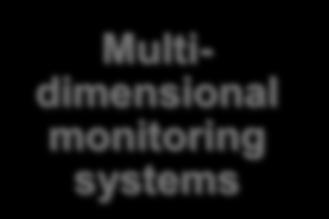


13 Environmental monitoring at OSS Water Soil Climate Multidimensional monitoring systems Socioeconomics Modeling Forecasting


14 Environmental monitoring at OSS Multidimensional monitoring systems In-situ observation Observatoires: ecological & socioeconomic data collection Spatial observation Earth observation, GIS, Mapping Harmonised indicators Livelihood SLWM Adaptation to CC
15 Bio-physical data Interface data Socio-eco data Thematic mapping and reference database Pedology Geomorphology Water system Soil Climate Water Vegetation Fauna Environmental monitoring at OSS Collected data Infrastructure Continuous monitoring Land cover Vegetation indices Operating area Availability Withdrawals Install History Land tenure Ethnic groups Administrative limits Population Operating systems Micro-economy


16 Environmental monitoring : In-situ observation Capacity building: development of training kits and organization of workshops on data collection and processing and computation of indicators Harmonization of approaches: elaboration of methodological guides Development of tools: functional observatories for local environment surveillance Sensitization activities: targeting local populations as well as decision makers Results dissemination: Data collection reports, regional synthesis

17 Environmental monitoring : In-situ observation Regional level: Observatories network
18 Environmental monitoring : In-situ observation National level: Environmental Monitoring Device

 Conception and realization")

19 Environmental monitoring : Spatial observation Capacity building: training and continuous technical guidance of national institution partners Mobilization of partners and technical institutions at national, regional and international levels (ASAL, AGRHYMET, ESA ) Conception and realization of cartographic products based on earth observation data and spatial analysis techniques Data dissemination: development and realization of thematic atlases, geoportals


20 Environmental monitoring : Spatial observation Capacity building activities Development of Training Kits Organization of training sessions at regional and national levels


21 Environmental monitoring : Spatial observation Land cover mapping at local scale Nouakchott, Mauritanie Bourem, Mali Tondikandia, Niger Hautes steppes oranaises, Algérie Oued Mird, Morocco Menzel Habib, Tunisia


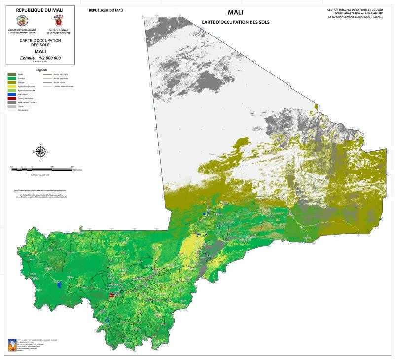

22 Environmental monitoring : Spatial observation Land cover mapping at national and regional scales


23 Environmental monitoring : Spatial observation Climate change vulnerability analysis and related risks


24 Environmental monitoring : Spatial observation Near real-time monitoring of bioclimatic indicators Data collected from the satellite receiving station: GEONETCast

 Water")
 Estimation of crop water consumption (SASS")
25 Environmental monitoring : Spatial observation Earth observation in support for transboundary aquifer management Basin wide Evapotranspiration, Precipitation and Water Balance (SAI aquifer) Water and Vegetation Monitoring over entire Aquifer (SAI aquifer) Estimation of crop water consumption (SASS aquifer)


 In-situ")

26 Environmental monitoring : Combining in-situ and spatial observation Example of application: Carbon sequestration potential 1) In-situ biomass measures 2) Calibration Model using NDVI data 3) Carbon sequestration map

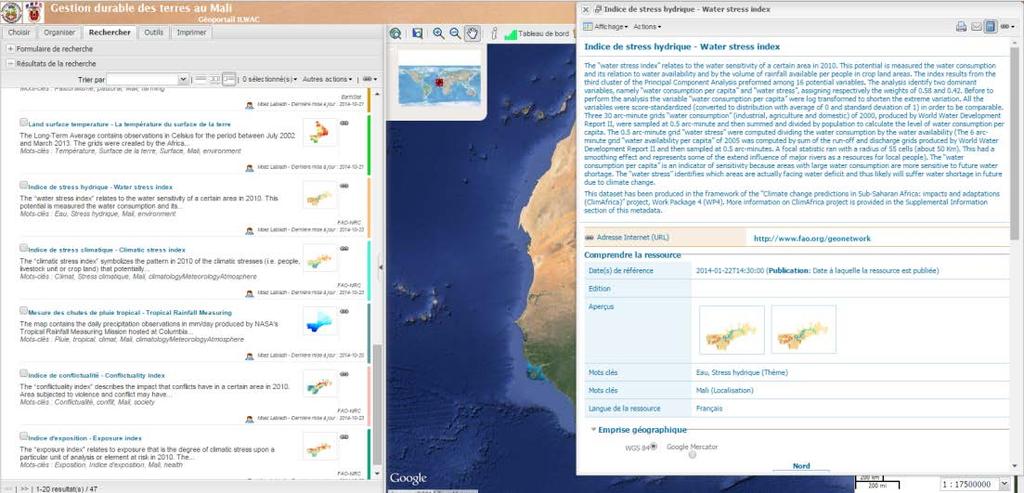


27 Environmental monitoring : Data dissemination Thematic Atlas, web map servers and Geo-catalogues

 - Development of models to monitor bioclimatic indicators TIGER - Capacity buiding in the use of EO techniques for water recources")
28 Environmental monitoring : Current activities at OSS REPSAHEL - Specifications of map products - Land cover and vegetation maps - Guidance and technical support - Web map server ORIXAS Spatial models for: - Land cover changes - Desertification - Forest-savannah and savannasteppe transition zones AGRICAB - Operational satellite receiving station (GEONETCast) - Near real time EO data (meteosat, MODIS, ) - Development of models to monitor bioclimatic indicators TIGER - Capacity buiding in the use of EO techniques for water recources management
29 Environmental monitoring : Current activities at OSS BRICKS - Atlas for the GGW region - Geoportal - Spatial M&E tools - Methodological and technical and support ILWAC - Land cover mapping - CC related risks mapping - SLM practices mapping - Data dissemination : Atlas, Geoportal SASS - Spatialization of water demand in the basin scale - Assessment of withdrawals rates at aquifer level using remote sensing - Data dissemination : Geoportal GICRESAIT - Aquifer recharge maps - Hydrodynamic parameters maps - CC vulnerability of groundwater - Risk of groundwater pollution by human activities -

30 Environmental information in Africa: Lessons learned Strong dependence on international aid in terms of data production and processing Poor understanding of the needs of data users (clients) Little integration of information systems at a national level, and even less at a regional level Duplication of effort at the regional scale in the areas of the acquisition and processing of regional-scale satellite remote sensing products
31 Environmental information in Africa: Lessons learned Harmonize environmental monitoring tools and methods Implement global and comprehensive monitoring systems involving the concerned stakeholders Build the capacities of national institutions in the collection, processing and dissemination of useful environmental data Transform raw data into information and make it accessible in the needed space, time and form Share best practices at regional and global scales


32 Thank you Visit our Website:
Innovative Financing through Innovative Partnerships. Nora Berrahmouni, Christophe Besacier FAO Forestry Department
 Innovative Financing through Innovative Partnerships Nora Berrahmouni, Christophe Besacier FAO Forestry Department Presentation of two examples 1. Support to the implementation of the Great Green Wall
UNESCO International Hydrological Programme (IHP)
") UNESCO International Hydrological Programme (IHP) Activities related to Groundwater Resources Management in the Sahel Zone International Hydrological Programme The only global intergovernmental scientific
UNESCO International Hydrological Programme (IHP) Activities related to Groundwater Resources Management in the Sahel Zone International Hydrological Programme The only global intergovernmental scientific
The Sahel and West Africa Program (SAWAP) in Support of the Great Green Wall Initiative
 in Support of the Great Green Wall Initiative") Sahel and West Africa Program (SAWAP) in Support of the Great Green Wall Initiative Using landscape approaches for climate resilience, food and water security, and ultimately more growth and less poverty.
Sahel and West Africa Program (SAWAP) in Support of the Great Green Wall Initiative Using landscape approaches for climate resilience, food and water security, and ultimately more growth and less poverty.
CILSS / AGRHYMET Role in The Reduction of Food Crises and Other Hydroclimatic Disasters in West Africa
 CILSS / AGRHYMET Role in The Reduction of Food Crises and Other Hydroclimatic Disasters in West Africa 1 Context Outline The Sahel droughts of the early 1970s and the Creation of CILSS Monitoring and Early
Assessment of the environmental, social and economic impacts of investments in SLWM in the Sahel region: the example of SAWAP
 BRICKS PROJECT BUILDING RESILIENCE THROUGH INNOVATION, COMMUNICATION AND KNOWLEDGE THE WORLD BANK / GEF S SAHEL AND WEST AFRICA PROGRAM (SAWAP) Assessment of the environmental, social and economic impacts
Circum Saharan Transboundary Aquifers: Inventory and challenges for Management
 Circum Saharan Transboundary Aquifers: Inventory and challenges for Management UNESCO-IAH-UNDP conference, Paris, 6-8 December 2010 A. Mamou 1 (1) Sahara and Sahel Observatory- BP 31 1080 Charguia-Tunis.
Support to African countries in implementation of the UN Convention to Combat Desertification (Report to the Third Conference of the Parties)
") European Community Support to African countries in implementation of the UN Convention to Combat Desertification (Report to the Third Conference of the Parties) June 1999 Contents 1. Overview: EC-Africa
European Community Support to African countries in implementation of the UN Convention to Combat Desertification (Report to the Third Conference of the Parties) June 1999 Contents 1. Overview: EC-Africa
AGRHYMET Assistance to NMSs In West Africa
 Workshop on "Achieving Benefits of Enhanced Service Delivery by NMSs in ESA AGRHYMET Assistance to NMSs In West Africa By Papa Oumar Dieye Head of Communication Outline of the Presentation Presentation
4th World Water Forum
 CONSULTED MANAGEMENT OF A SHARED RESOURCE CASE OF THE NORTH WESTERN SAHARA AQUIFER SYSTEM 4th World Water Forum Christophe Ducastel FFEM Djamel Latrech OSS 1 GREAT SHARED CIRCUM SAHARA BASINS 2 BASINS
(BRICKS) Compendium of best practices in sustainable land management for dissemination
 Compendium of best practices in sustainable land management for dissemination") BUILDING RESILIENCE THROUGH INNOVATION, COMMUNICATION AND KNOWLEDGE SERVICES PROJECT (BRICKS) Compendium of best practices in sustainable land management for dissemination TERMS OF REFERENCE I. BACKGROUND
BUILDING RESILIENCE THROUGH INNOVATION, COMMUNICATION AND KNOWLEDGE SERVICES PROJECT (BRICKS) Compendium of best practices in sustainable land management for dissemination TERMS OF REFERENCE I. BACKGROUND
An African response to Desertification, Land Degradation, drought, Climate Change and loss of biodiversity and Livelihoods
 An African response to Desertification, Land Degradation, drought, Climate Change and loss of biodiversity and Livelihoods Almami Dampha Dr. François Tapsoba The Great Green Wall supported by EU and FAO
Combating Desertification for. Sahel and the Horn of Africa. FAO s Experiences in the Sahel
 Combating Desertification for Resilience to Climate Change in the Sahel and the Horn of Africa FAO s Experiences in the Sahel Name of presenter Title Regional Meeting on African Initiative for Combating
The State of the World Bank/GEF Sahel and West Africa Program (SAWAP) For the Great Green Wall
 For the Great Green Wall") The The State of the /GEF Sahel and West Africa Program (SAWAP) For the Great Green Wall First Great Green Wall Conference (3 rd SAWAP Conference) Dakar May 5, 2016 The Sahel and West Africa Program (SAWAP
The The State of the /GEF Sahel and West Africa Program (SAWAP) For the Great Green Wall First Great Green Wall Conference (3 rd SAWAP Conference) Dakar May 5, 2016 The Sahel and West Africa Program (SAWAP
Drought Monitoring and Early Warning in West Africa. At the AGRHYMET Regional Center. By Seydou B. TRAORE,
 Drought Monitoring and Early Warning in West Africa At the AGRHYMET Regional Center By Seydou B. TRAORE, agrometeorologist 1 Outline Introduction Background information about AGRHYMET The Early Warning
Sub-Saharan African G-WADI
 Sub-Saharan African G-WADI Regional chapter of the Global network on Water and Development Information for Arid Lands Achievements and prospects Dr Abdou ALI, PB 11011, AGRHYMET, Niamey, Niger a.ali@agrhymet.ne
EU-Africa collaboration on Space applications for Africa
 EU-Africa collaboration on Space applications for Africa Background Maputo Declaration: African policy makers request EC to open its GMES initiative to Africa (Oct 2006) Build on existing EO activities
Sahara and Sahel Observatory
 An innovative framework for sustainable development in Africa Sahara and Sahel Observatory Knowledge Dialogue Joint action > Key words Virtuous circles context 2 The Sahara and Sahel regions are more home
JAES Action Plan Partnership on Climate Change and Environment
 JAES Action Plan 2011-2013 Partnership on Climate Change and Environment Overview The first Action Plan (2008-2010) for the implementation of the Joint Africa-EU Strategy (JAES) adopted in Lisbon Summit
Schedule of Side Events COP 13*
 Tuesday 5 September 8:00 12:00 : o 16 China Green Foundation The Land Greening Public Benefit Project Forum and the Second Expanded Meeting of the Seventh China Green Foundation Council MET-05 15:00 19:00
INTRODUCTION TO THE BREAKOUT SESSIONS. ESA-FAO-GWSP Workshop on WEF Rome, Italy March 25, 2014 Richard Lawford Cat Downy, Lucie Pluschke
 INTRODUCTION TO THE BREAKOUT SESSIONS ESA-FAO-GWSP Workshop on WEF Rome, Italy March 25, 2014 Richard Lawford Cat Downy, Lucie Pluschke The Breakout Groups are a critical element in the Workshop structure
Schedule of Side Events COP 13*
 Tuesday 5 September 8:00 12:00 : o 16 China Green Foundation The Land Greening Public Benefit Project Forum and the Second Expanded Meeting of the Seventh China Green Foundation Council MET-05 15:00 19:00
UNESCO s action for Groundwater Governance in Africa
 AFRICA Focus- Groundwater governance and institutional management UNESCO s action for Groundwater Governance in Africa Dr. Alice Aureli PhD Chief of the Section Groundwater Systems and HumanSettlements
REGIONAL ACHIEVEMENTS OF THE INTERNATIONAL HYDROLOGICAL PROGRAMME REGION 5a AFRICA
 United Nations Educational, Scientific and Cultural Organization International Hydrological Programme REGIONAL ACHIEVEMENTS OF THE INTERNATIONAL HYDROLOGICAL PROGRAMME REGION 5a AFRICA INTERNATIONAL HYDROLOGICAL
Introduction of JICA s Activities for the Forestry Sector in the Continent of Africa
 August 26 th, 2016 Introduction of JICA s Activities for the Forestry Sector in the Continent of Africa Mr. SHISHIDO Kenichi Deputy Director General for Nature Conservation Global Environment Department,
UNEP N eeds Needs for for LULC data and information
 UNEP Needs for LULC data and information By Ashbindu Singh Chief, Early Warning Branch UNEP Division of Early Warning& Assessment and Regional Coordinator UNEP Division of Early Warning & Assessment- North
INTERGOVERNMENTAL OCEANOGRAPHIC COMMISSION (of UNESCO)
") IOC/INF-1200 Paris, 8 June 2004 English only INTERGOVERNMENTAL OCEANOGRAPHIC COMMISSION (of UNESCO) FROM OBSERVATION TO ACTION ACHIEVING COMPREHENSIVE, COORDINATED AND SUSTAINED EARTH OBSERVATIONS FOR
IOC/INF-1200 Paris, 8 June 2004 English only INTERGOVERNMENTAL OCEANOGRAPHIC COMMISSION (of UNESCO) FROM OBSERVATION TO ACTION ACHIEVING COMPREHENSIVE, COORDINATED AND SUSTAINED EARTH OBSERVATIONS FOR
Presentation outline :
 Legal and Institutional Prescriptions for the implementation of the 3 Rio Conventions Annie Roncerel Senior Programme Coordinator Programme UNITAR Presentation outline : The Rio Conventions legal requirements
GEO Initiatives: GEOGLAM and AfriGEOSS
 GEO Initiatives: GEOGLAM and AfriGEOSS Andiswa Mlisa Michel Deshayes GEO Secretariat G4AWeek 21-24 September 2015, The Hague, Netherlands 87 Participating Organizations GEO Secretariat Information Value
Key elements of the GMES EC Draft Action Plan Initial Period
 Brussels, 27/07/2001 Key elements of the GMES EC Draft Action Plan Initial Period 2001-2003 For information: Michel.Cornaert@cec.eu.int Hugo.De_Groof@cec.eu.int Neil.Hubbard@jrc.it Errol.Levy@cec.eu.int
Land Resource Management Unit
 09/01/2013 Land Resource Management Unit www.jrc.ec.europa.eu Alan Belward Serving society Stimulating innovation Supporting legislation 1 Visit of Deputy DG Land Resource Management Unit s mission To
NATURAL RESOURCES DEPARTMENT (NR) GEF project: Adaptive Management and Monitoring of the Maghreb s Oases Systems
 GEF project: Adaptive Management and Monitoring of the Maghreb s Oases Systems") GEF project: Adaptive Management and Monitoring of the Maghreb s Oases Systems GEF project: Adaptive Management and Monitoring of the Maghreb s Oases Systems Recipient Countries: Algeria, Mauritania, Morocco
GEF project: Adaptive Management and Monitoring of the Maghreb s Oases Systems GEF project: Adaptive Management and Monitoring of the Maghreb s Oases Systems Recipient Countries: Algeria, Mauritania, Morocco
Chapter 13 of Agenda 21
 Chapter 13 of Agenda 21 What is Agenda 21? Agenda 21 is the global plan of action that was adopted at the United Nations Conference on Environment and Development (UNCED) held in Rio de Janeiro, Brazil,
Earth observations for water resource management: Current practice and examples
 Earth observations for water resource management: Current practice and examples NEW OPPORTUNITIES IN SATELLITE AND AIRBORNE REMOTE SENSING: Hydrological and Environmental Applications DTU Environment Lyngby
Drought monitoring and early warning in the Sahel : The AGRHYMET experience
 Drought monitoring and early warning in the Sahel : The AGRHYMET experience Presentation at the World Conference on Disaster Reduction Kobe, Japan, 18 22 January, 2005 by Dr Seydou B. TRAORE Agrometeorologist
A post second session of the United Nations Environment Assembly (UNEA-2) consultation workshop for stakeholders in East and Southern Africa region
 consultation workshop for stakeholders in East and Southern Africa region") A post second session of the United Nations Environment Assembly (UNEA-2) consultation workshop for stakeholders in East and Southern Africa region TERRESTRIAL ECOSYSTEMS UNIT UN-REDD & landscapes TERRESTRIAL
A post second session of the United Nations Environment Assembly (UNEA-2) consultation workshop for stakeholders in East and Southern Africa region TERRESTRIAL ECOSYSTEMS UNIT UN-REDD & landscapes TERRESTRIAL
Synergies between UNFCCC and UNCCD in Africa: Experiences made in implementing the UNCCD
 Synergies between UNFCCC and UNCCD in Africa: Experiences made in implementing the UNCCD Bettina Horstmann, Coordinator Africa Unit, UNCCD Secretariat. United Nations Convention to Combat Desertification
Input to UNFF8 by the Southern African Development Community (SADC)
") Preamble Input to UNFF8 by the Southern African Development Community (SADC) All SADC member states signed and ratified the UN Framework Convention on Climate Change, the Kyoto Protocol, Convention on
Preamble Input to UNFF8 by the Southern African Development Community (SADC) All SADC member states signed and ratified the UN Framework Convention on Climate Change, the Kyoto Protocol, Convention on
List of acronyms & abbreviations
 List of acronyms & abbreviations ABN : Niger Basin Authority AfDB : African Development Bank AGRHYMET : Centre Régional de Formation et d Application en Agrométéorologie et Hydrologie Opérationnelle ASTER
Annual General Meeting 2001 October Washington DC, USA STAKEHOLDER MEETING
 Consultative Group on International Agricultural Research (CGIAR) Document No: AGM/01/12 Distribution: General Date : October 15, 2001 Annual General Meeting 2001 October 30-31 Washington DC, USA STAKEHOLDER
SUSTAINABLE MOUNTAIN DEVELOPMENT REPORT OF THE SECRETARY GENERAL TO THE UN GENERAL ASSEMBLY 2009
 SUSTAINABLE MOUNTAIN DEVELOPMENT REPORT OF THE SECRETARY GENERAL TO THE UN GENERAL ASSEMBLY 2009 Introduction The present report was prepared in July 2009 by FAO in response to the General Assembly resolution
Convention to Combat Desertification
 UNITED NATIONS Convention to Combat Desertification Distr. GENERAL ICCD/COP(8)/CST/2/Add.8 12 July 2007 ORIGINAL: ENGLISH CONFERENCE OF THE PARTIES Committee on Science and Technology Eighth Session Madrid,
Institute for Environment and Sustainability
 JRC Institute for Environment and Sustainability 1 Institute for Environment and Sustainability Prof. Dr Leen Hordijk Director Our strategic goals JRC Institute for Environment and Sustainability 2 Strategic
Voluntary Guidelines for Securing Sustainable Small-Scale Fisheries in the Context of Food Security and Poverty Eradication
 Voluntary Guidelines for Securing Sustainable Small-Scale Fisheries in the Context of Food Security and Poverty Eradication At a glance 2 What are the SSF Guidelines? The Voluntary Guidelines for Securing
Dryland Livestock Wildlife Environment Interface Project (DLWEIP)
") Dryland Livestock Wildlife Environment Interface Project (DLWEIP) Experiences and Lessons from Livestock-Wildlife Wildlife- Environment Interface Management in Kenya and Burkina Faso By S. Nouala (AU/IBAR)
Dryland Livestock Wildlife Environment Interface Project (DLWEIP) Experiences and Lessons from Livestock-Wildlife Wildlife- Environment Interface Management in Kenya and Burkina Faso By S. Nouala (AU/IBAR)
THE GLOBAL WATER CYCLE THEME WITHIN THE INTEGRATED GLOBAL OBSERVING STRATEGY FRAMEWORK
 THE GLOBAL WATER CYCLE THEME WITHIN THE INTEGRATED GLOBAL OBSERVING STRATEGY FRAMEWORK RICK LAWFORD & JOSEF ASCHBACHER WATER FOR THE WORLD: SPACE SOLUTIONS FOR WATER MANAGEMENT SEPTEMBER 13, 2004 GRAZ,
NASA s Contribution to Water Research, Applications, and Capacity Building in Africa
 NASA s Contribution to Water Research, Applications, and Capacity Building in Africa Nancy D. Searby 1, David Toll 2, Rick Lawford 3, 1 NASA HQ Earth Sciences Division Applied Sciences Program 2 NASA GSFC
26-28 FEB 2019 BEATING FAMINE CONFERENCE THE SAHEL. Do please join us! Registrations are live. The Sahel knows how to beat. famine.
 Registrations are live The Sahel knows how to beat 26-28 FEB 2019 famine Come and BEATING FAMINE CONFERENCE THE SAHEL Meeting the AFR100 Challenge The third in the series of Beating Famine Conferences
Chart 2 > Vortrag > Autor Dokumentname > Datum
 www.dlr.de Chart 1 > Vortrag > Autor Dokumentname > Datum www.dlr.de Chart 2 > Vortrag > Autor Dokumentname > Datum www.dlr.de Chart 3 > Vortrag > Autor Dokumentname > Datum www.dlr.de Chart 4 > Vortrag
SAWAP Conference & BRICKS Launch Sahel and West Africa Program in Support of the Great Green Wall Initiative
 & SAWAP Conference & BRICKS Launch Sahel and West Africa Program in Support of the Great Green Wall Initiative Building Resilience through Innovation, Communication and Knowledge Services Project March
Disaster Early Warning and Response Activities at RCMRD Tesfaye Korme (Ph.D), Regional Centre for Mapping of Resources for Development
, Regional Centre for Mapping of Resources for Development") Satellite Earth Observation & Disaster Risks Disaster Early Warning and Response Activities at RCMRD Tesfaye Korme (Ph.D), Regional Centre for Mapping of Resources for Development RCMRD and its member
Satellite Earth Observation & Disaster Risks Disaster Early Warning and Response Activities at RCMRD Tesfaye Korme (Ph.D), Regional Centre for Mapping of Resources for Development RCMRD and its member
Strategic Initiative on Climate Change Impacts, Adaptation, and Development in Mountain Regions. Presentation of the Position Paper.
 Strategic Initiative on Climate Change Impacts, Adaptation, and Development in Mountain Regions Presentation of the Position Paper Riad BALAGHI FAO consultant National Agricultural Research Institute of
Service: status & evolution
 The Copernicus Global Land Service: status & evolution R. Lacaze HYGEOS on behalf the GIO - Global Land consortium What is Copernicus? The European system for monitoring i the Earth The European response
WOCAT International Secretariat who we are what we do how we do it main achievements outlook challenges & opportunities
 WOCAT International Secretariat who we are what we do how we do it main achievements outlook challenges & opportunities Renate Fleiner / 15 June 2017, Cali Introduction The WOCAT International Secretariat
ICRISAT REPORT TO COP3
 ICRISAT REPORT TO COP3 Joining hands to implement the CCD Convention in the desert margins of sub-saharan Africa Report prepared by Drs. S. Koala and Niek van Duivenbooden on behalf of the International
Land Degradation Control in North Africa
 Land Degradation Control in North Africa By Dr. Ismail Hamdi El-Bagouri Emeritus Professor Soil and Water Conservation Desert Research Center Egypt International Workshop on Climate and Land Degradation
Contributions to the 2030 Agenda for Sustainable Development
 Contributions to the 2030 Agenda for Sustainable Development ECOSOC functional commissions and other intergovernmental bodies and forums, are invited to share relevant input and deliberations as to how
The Partnership for Agricultural Water for Africa
 The Partnership for Agricultural Water for Africa TABLE OF CONTENTS The Partnership SDC Project Support to sustainable agricultural water management and the pre- and post-caadp compact process in Burkina
By V. Otieno, E. Kayijamahe & A. Royer
 13 th EUMETSAT Users Forum - September 2018 IGAD Climate Prediction and Applications Centre - ICPAC USE OF MESA STATIONS FOR NATURAL RESOURCE AND FOOD SECURITY MONITORING By V. Otieno, E. Kayijamahe &
Socio-economic Data for Drylands Monitoring The Living Standards Measurement Study Integrated Surveys on Agriculture
 Socio-economic Data for Drylands Monitoring The Living Standards Measurement Study Integrated Surveys on Agriculture Alberto Zezza (Development Research Group, World Bank) www.worldbank.org/lsms Monitoring
Overview of the GEF6 Integrated Approach Pilot Programs. Early Lessons from Programming
 Overview of the GEF6 Integrated Approach Pilot Programs Early Lessons from Programming Integrated Approach Pilots: Charting a New Frontier for the Global Environment Schlosser & Pfirman, Nature Geosciences,
Overview of the GEF6 Integrated Approach Pilot Programs. Early Lessons from Programming
 Overview of the GEF6 Integrated Approach Pilot Programs Early Lessons from Programming Integrated Approach Pilots: Charting a New Frontier for the Global Environment Schlosser & Pfirman, Nature Geosciences,
Review of transboundary waters in the Arab region: Pressures and management issues
 Review of transboundary waters in the Arab region: Pressures and management issues Carol Chouchani Cherfane Chief, Water Resources Section Sustainable Development and Productivity Division, ESCWA Workshop
Forest Landscape Restoration Mechanism and Integrated land-use in Africa
 Forest Landscape Restoration Mechanism and Integrated land-use in Africa Soalandy Rakotondramanga, Eugene Rurangwa FAO Regional Office for Africa, Major Area of Work Ecosystem Services and Biodiversity
Drought management-related activities and achievements in the Near East and North Africa Region:
 UN- DESA UN-ESCWA Expert Group and Inception Meeting on Strengthening National Capacities to Manage Water Scarcity and Drought in West Asia and North Africa Drought management-related activities and achievements
A short history of Drought Risk Networking
 A short history of Drought Risk Networking Mohamed Abchir, PHD, ISDR-Secretariat The ISDR Ad Hoc Discussion Group on Drought TOR, Membership, Main Recommendations Regional Drought Preparedness network
THE TIGER INITIATIVE. Looking After Water in Africa
 THE TIGER INITIATIVE Looking After Water in Africa In 2002, responding to the urgent need for action in Africa stressed by the Johannesburg World Summit on Sustainable Development (WSSD), the European
Applications for. Management. Agricultural Risk Management Team. The World Bank
 Geospatial Technology Applications for Agricultural Risk Management Agricultural Risk Management Team Agriculture and Environmental Services Department The World Bank Agricultural Risks : Cross Cutting
The Mountain Partnership and the NENA Region. Amman 2014
 The Mountain Partnership and the NENA Region Amman 2014 In this presentation: The Mountain Agenda since 1992 What is the Mountain Partnership Why mountains are important in the NENA Region What is the
REPORT OF THE UNITED NATIONS CONFERENCE ON ENVIRONMENT AND DEVELOPMENT MANAGING FRAGILE ECOSYSTEMS: COMBATING DESERTIFICATION AND DROUGHT
 Agenda 21, Chapter 12 Distr. GENERAL A/CONF.151/26 (Vol. II), 13 August 1992 ORIGINAL: ENGLISH REPORT OF THE UNITED NATIONS CONFERENCE ON ENVIRONMENT AND DEVELOPMENT (Rio de Janeiro, 3-14 June 1992) Chapter
AGRHYMET role in the PRESA SS. and PRESA GG processes in West Africa
 AGRHYMET role in the PRESA SS and PRESA GG processes in West Africa By Seydou B. TRAORE AGRHYMET Regional Center Niamey, Niger WMO WORKSHOP ON GLOBAL REVIEW OF REGIONAL CLIMATE OUTLOOK FORUMS 5-7 September,
EO4SDGs and Disaster Risk Reduction Virginia Burkett Chief Scientist, USGS Climate and Land Use Change
 EO4SDGs and Disaster Risk Reduction Virginia Burkett Chief Scientist, USGS Climate and Land Use Change U.S. Department of the Interior U.S. Geological Survey United Nations (2015): Sendai Framework for
Inventory of African transboundary aquifer systems
 Inventory of African transboundary aquifer systems B. Appelgren UNESCO/ISARM 1 Outline Part I. African TBA Inventory: aspirations and objectives Part II. ISARM 2002/2004 Inventory Part III. Conclude 2
The United Nations Office for Outer Space Affairs: its role and the support it provides
 The United Nations Office for Outer Space Affairs: its role and the support it provides SIMONETTA DI PIPPO, DIRECTOR United Nations Office for Outer Space Affairs United Nations Office at Vienna www.unoosa.org
Applying the transboundary biosphere reserve model to promote peace in the Lake Chad basin through sustainable management of its natural resources
 Complementary Additional Programme 2014-2015 / Concept note Applying the transboundary biosphere reserve model to promote peace in the Lake Chad basin through sustainable management of its natural resources
INGOs and IGOs Role in Strengthening Regional Partnerships
 INGOs and IGOs Role in Strengthening Regional Partnerships United Nations Office for Outer Space Affairs: Global Mandates The Office implements the decisions of the General Assembly and of the United Nations
Drought Monitoring and Early Warning Systems
 World Meteorological Organization Working together in weather, climate and water Drought Monitoring and Early Warning Systems Robert Stefanski Chief, Agricultural Meteorology Division Climate and Water
MINISTÈRE DES AFFAIRES ÉTRANGÈRES ET EUROPÉENNES 20 December /5 6th World Water Forum Ministerial Process Draft document
 MINISTÈRE DES AFFAIRES ÉTRANGÈRES ET EUROPÉENNES 20 December 2011 1/5 6th World Water Forum Ministerial Process Draft document 1. We the Ministers and Heads of Delegations assembled in Marseille, France,
INTEGRATED DROUGHT MANAGEMENT PROGRAMME A Joint WMO-GWP Programme. Concept Note
 INTEGRATED DROUGHT MANAGEMENT PROGRAMME A Joint WMO-GWP Programme Concept Note Status: July 2010 INTEGRATED DROUGHT MANAGEMENT A Joint WMO-GWP Programme SUMMARY OF THE PROGRAMME Project Title: Integrated
Earth Observation in support for project identification/preparation
 Asian Water Forum Oct. 5th 2018 Asian Development Bank Manila, Philippines Earth Observation in support for project identification/preparation Christian Tottrup, DHI GRAS EO4SD -> Background Water plays
UNITED NATIONS CONFERENCE ON SUSTAINABLE DEVELOPMENT RIO+20 INPUTS FOR COMPILATION DOCUMENT
 UNITED NATIONS CONFERENCE ON SUSTAINABLE DEVELOPMENT RIO+20 INPUTS FOR COMPILATION DOCUMENT SUBMISSION 1: MAJOR GROUPS OTHER ORGANIZATIONS ORGANIZATION: CENTRO DE GESTÃO E ESTUDOS ESTRATÉGICOS CGGE COUNTRY:
Maximize the production of goods and services of Mediterranean forest ecosystems in the context of global changes
 1-3 April 2014 Paris France From science to practice: the contribution of projects TipTree and AMTools to guiding better forest survival and regeneration under global change scenarios Maximize the production
SUSTAINABLE LAND AND CLIMATE RISK MANAGEMENT FOR THE SAHARA AND SAHEL INITIATIVE DAKAR, SENEGAL,10-17 JUNE 2011
 FIRST AFRICA DRYLANDS WEEK: TOWARDS A GLOBAL VISION AND PARTNERSHIP ON THE SUSTAINABLE LAND AND CLIMATE RISK MANAGEMENT FOR THE SAHARA AND SAHEL INITIATIVE DAKAR, SENEGAL,10-17 JUNE 2011 TREES OUTSIDE
Securing Soil Carbon Benefits. UNEP Year Book 2014 emerging issues update
 2012 emerging environmental issue The benefits of soil carbon: managing soils for multiple economic, societal and environmental benefits UNEP Year Book 2014 emerging issues update Securing Soil Carbon
Support to the implementation of the Great Green Wall for the Sahara and the Sahel Initiative (GGWSSI)
") Support to the implementation of the Great Green Wall for the Sahara and the Sahel Initiative (GGWSSI) African Union Commission Projects supported by the European Union, FAO and the Global Mechanism of
Support to the implementation of the Great Green Wall for the Sahara and the Sahel Initiative (GGWSSI) African Union Commission Projects supported by the European Union, FAO and the Global Mechanism of
GEO WEEK KYOTO, JAPAN Monday 29 October, EU Africa cooperation in Earth Observation
 GEO WEEK 2018 KYOTO, JAPAN, 11.00-12.30 EU Africa cooperation in Earth Observation Promoting GEOSS and COPERNICUS in NAMEBA: the GEO-CRADLE EU project and GEO Initiative Dr. Haris Kontoes GEO-CRADLE Project
Mrs NOASILALAONOMENJANAHARY A. Lucie GEO- DSWG Member National Focal Point AfriGEOSS - Madagascar
 Mrs NOASILALAONOMENJANAHARY A. Lucie GEO- DSWG Member National Focal Point AfriGEOSS - Madagascar GEO plenary side event DSWG and DMP TF 12 November 2014 14h00 17h30 PLAN AfriGEOSS in General (Background,
For: Approval. Note to Executive Board representatives. Document: EB 2016/LOT/G.19 Date: 21 November Focal points:
 Document: EB 2016/LOT/G.19 Date: 21 November 2016 Distribution: Public Original: English E President s report on a proposed grant under the global/regional grants window to the World Agroforestry Centre
Dryland Degradation: What Should We Monitor and How? Alan Grainger School of Geography, University of Leeds
 Dryland Degradation: What Should We Monitor and How? Alan Grainger School of Geography, University of Leeds Who Needs Information? Who Needs Information? All the bodies who need information on the drylands
Report of the Executive Committee of the Warsaw International Mechanism for Loss and Damage associated with Climate Change Impacts
 Decision -/CP.24 Report of the Executive Committee of the Warsaw International Mechanism for Loss and Damage associated with Climate Change Impacts The Conference of the Parties, Recalling decisions 3/CP.18,
LAKE CHAD BASIN COMMISSION
 LAKE CHAD BASIN COMMISSION FIRST COORDINATION MEETING OF THE SAHEL PROJECT INSTITUTIONAL FRAMEWORK, ON-GOING ACTIVITIES AND COOPERATION 6TH MAY 2014 MOHAMMED BILA LAKE CHAD BASIN OBSERVATORY NDJAMENA,
Connecting Space to Village in the Hindu Kush Himalaya. Objectives
 Connecting Space to Village in the Hindu Kush Himalaya SERVIR connects space to village by helping developing countries use satellite data to address challenges in food security, water resources, weather
CREWS Project Status Report
 CREWS Project Status Report 1 Project Title Strengthening national capacities for EWS Service Delivery in Burkina Faso 2 Project [As provided by the Secretariat] Reference 3 Reporting June-November 2017
GEO-CRADLE project in context of regional needs
 GEO-CRADLE project in context of regional needs Funded under H2020 - Climate action, environment, resource efficiency and raw materials ACTIVITY: Developing Comprehensive and Sustained Global Environmental
Annex II. List of Spatial Information Networks
 Annex II. List of Spatial Information Networks FAO- SPATIAL INFORMATION NETWORKS Agro-Maps Data Sources http://www.fao.org/ag/agl/agll/agromaps/datasource.jsp CLIMWAT http://www.fao.org/landandwater/aglw/climwat.stm
AU-SAFGRAD s activities in support to Combat Desertification in Africa. Dry Land Week 8-12 August 2016
 AU-SAFGRAD s activities in support to Combat Desertification in Africa Dry Land Week 8-12 August 2016 Outline 1. Major Activities and Achievements 2. Role of Science and Technology in Combating Desertification
WELCOME TO THE AGRHYMET REGIONAL CENTRE
 WELCOME TO THE AGRHYMET REGIONAL CENTRE Risk identification, monitoring and early warning system : main activities of Agrhymet Regional Centre Presented by Dr Benoît SARR Agrometeorologist, Agrhymet Regional
GEOGLAM Global Agricultural Monitoring. Michel Deshayes
 GEOGLAM Global Agricultural Monitoring Michel Deshayes mdeshayes@geosec.org Outline GEOGLAM and AMIS GEOGLAM Structure and Governance New activities and projects Rangelands and Pasture Monitoring Early
Oceans and Seas, Forests, Biodiversity
 Oceans and Seas, Forests, Biodiversity A presentation by Alfred A. Oteng-Yeboah, Professor, University of Ghana, Legon, Ghana; Vice-Chair (Africa), Bureau of IPBES to the 8 th Session of the General Assembly
GMES and AFRICA
 Global Monitoring for Environment and Security Mauro.Facchini@ec.europa.eu GMES and AFRICA What is GMES? European response to global needs to manage the environment, understand and mitigate the effects